South-West Deeps (West) MCZ Post-survey Site...
78
South-West Deeps (West) MCZ Post-survey Site Report Contract Reference: MB0120 Report Number: 21 Version 7 March 2015
Transcript of South-West Deeps (West) MCZ Post-survey Site...

South-West Deeps (West) MCZ Post-survey Site Report
Contract Reference: MB0120
Report Number: 21 Version 7
March 2015

Project Title: Marine Protected Areas Data and Evidence Co-ordination Programme Report No 21. Title: South-West Deeps (West) MCZ Post-survey Site Report Defra Project Code: MB0120 Defra Contract Manager: Carole Kelly
Funded by:
Department for Environment, Food and Rural Affairs (Defra) Marine Science and Evidence Unit Marine Directorate Nobel House 17 Smith Square London SW1P 3JR
Authorship
Dayton Dove British Geological Survey (BGS) [email protected]
Rhys Cooper British Geological Survey (BGS) [email protected]
Sophie Green British Geological Survey (BGS) [email protected]
Acknowledgements
We thank Alex Callaway and Sue Ware (Cefas) for reviewing earlier drafts of this report.
Disclaimer: The content of this report does not necessarily reflect the views of Defra, nor is Defra liable for the accuracy of information provided, or responsible for any use of the reports content. Although the data provided in this report has been quality assured, the final products - e.g. habitat maps – may be subject to revision following any further data provision or once they have been used in SNCB advice or assessments.

Cefas Document Control Title: South-West Deeps (West) MCZ Post-survey Site Report Submitted to: Marine Protected Areas Survey Co-ordination & Evidence Delivery Group
Date submitted: March 2015
Project Manager: David Limpenny
Report compiled by: Dayton Dove, Rhys Cooper, Sophie Green
Quality control by: Joanna Murray and Robin Law
Approved by & date: Keith Weston (02/03/2015)
Version: V7
Version Control History
Author Date Comment Version
Dove et al. 10/02/2014 1st draft to internal reviewer V1
Dove et al. 06/03/2014 Revised draft following Cefas review V2
Dove et al. 03/04/2014 Revised draft following updated HOCI definitions V3
Dove et al. 16/05/2014 Revised draft following Cefas review V4
Dove et al. 29/09/2014 Revised draft following IER and MPAG review V5
Sue Ware 10/12/2014 Revised draft following additional comment from PSG V6
Keith Weston 02/03/2015 Revised following Defra comments V7

South-West Deeps (West) MCZ Post-survey Site Report i
Table of Contents
Table of Contents ........................................................................................................ i
List of Tables .............................................................................................................. iii
List of Figures ............................................................................................................. iv
1 Executive Summary: Report Card ................................................................. 1
1.1 Features proposed in the SAD for inclusion within the MCZ designation ...... 1
1.2 Features present but not proposed in the SAD for inclusion within the MCZ designation .................................................................................................... 2
1.3 Evidence of human activities occurring within the MCZ ................................ 2
2 Introduction ................................................................................................... 3
2.1 Location of the MCZ ...................................................................................... 4
2.2 Rationale for site position and designation .................................................... 4
2.3 Rationale for prioritising this MCZ for additional evidence collection ............. 5
2.4 Survey aims and objectives .......................................................................... 6
3 Methods ........................................................................................................ 7
3.1 Acoustic data acquisition ............................................................................... 7
3.2 Ground truth sample acquisition .................................................................... 7
3.3 Production of the updated habitat map ......................................................... 9
3.4 Quality of the updated map ......................................................................... 13
4 Results ........................................................................................................ 14
4.1 Site Assessment Document (SAD) habitat map .......................................... 14
4.2 Updated habitat map based on new survey data ........................................ 14
4.3 Quality of the updated habitat map ............................................................. 16
4.4 Broadscale habitats identified ..................................................................... 16
4.5 Habitat FOCI identified ................................................................................ 18
4.6 Species FOCI identified .............................................................................. 19
4.7 Quality Assurance (QA) and Quality Control (QC) ...................................... 19
4.8 Data limitations and adequacy of the updated habitat map ......................... 20
4.9 Observations of human impacts on the seabed .......................................... 20
5 Conclusions ................................................................................................ 21
5.1 Presence and extent of broadscale habitats ............................................... 21
5.2 Presence and extent of habitat FOCI .......................................................... 21
5.3 Presence and distribution of species FOCI ................................................. 22
5.4 Evidence of human activities impacting the seabed .................................... 22
References ............................................................................................................... 23
Data sources ............................................................................................................ 25

South-West Deeps (West) MCZ Post-survey Site Report ii
Annexes ................................................................................................................... 26
Annex 1. Broadscale habitat features listed in the ENG. ..................................... 26
Annex 2. Habitat FOCI listed in the ENG. ............................................................ 27
Annex 3. Low or limited mobility species FOCI listed in the ENG. ....................... 28
Annex 4. Highly mobile species FOCI listed in the ENG. ..................................... 29
Annex 5. Video and stills processing protocol. .................................................... 30
Appendices .............................................................................................................. 32
Appendix 1. Survey metadata (CEND 06/13) ...................................................... 32
Appendix 2. Outputs from acoustic surveys ......................................................... 44
Appendix 3. Evidence of Human Activities within the MCZ .................................. 47
Appendix 4. Species list ....................................................................................... 49
Appendix 5. BSH/EUNIS Level 3 descriptions derived from video and stills ........ 60
Appendix 6. Example images from survey for broadscale habitats ..................... 68
Appendix 7. Example images from survey for habitat FOCI ................................ 69

South-West Deeps (West) MCZ Post-survey Site Report iii
List of Tables
Table 1. Broadscale habitats for which this MCZ was proposed for designation. ...... 5
Table 2. Habitat FOCI for which this MCZ was proposed for designation. ................ 5
Table 3. Species FOCI for which this MCZ was proposed for designation.. .............. 5
Table 4. Description of derivatives calculated for bathymetry using ArcGIS/Fledermaus. ........................................................................................ 10
Table 5. Broadscale habitats identified in this MCZ. ............................................... 17
Table 6. Habitat FOCI identified in this MCZ. .......................................................... 18
Table 7. Species FOCI identified in this MCZ. ......................................................... 19

South-West Deeps (West) MCZ Post-survey Site Report iv
List of Figures
Figure 1. Location of the South-West Deeps (West) MCZ. ....................................... 4
Figure 2. Location of ground truth sampling sites in the South-West Deeps (West) MCZ. ................................................................................................................ 9
Figure 3. Backscatter mosaic generalisation/smoothing prior to autoclassification routine. ............................................................................................................. 11
Figure 4. Iso cluster maximum likelihood classification routine. .............................. 12
Figure 5. Habitat map from the Site Assessment Document. .................................. 14
Figure 6. Updated map of broadscale habitats based on newly acquired survey data. ................................................................................................................. 15
Figure 7. Overall MESH confidence score for the updated broadscale habitat map. ......................................................................................................................... 16
Figure 8. Habitat FOCI identified. ............................................................................ 18
Figure 9. Distribution of stations where the species FOCI Fan Mussel Atrina fragilis was recorded. .................................................................................................. 19

South-West Deeps (West) MCZ Post-survey Site Report 1
1 Executive Summary: Report Card
This report details the findings of dedicated seabed surveys at the South-West Deeps (West), now designated as a Marine Conservation Zone (MCZ) within the UK network of Marine Protected Areas (MPAs) designed to meet conservation objectives under the Marine and Coastal Access Act 2009. Prior to the dedicated surveys, the site assessment had necessarily been made on the basis of ‘best available evidence’, drawn largely from historical data, modelled habitat maps and stakeholder knowledge of the area. The purpose of the survey was to provide direct evidence of the presence and extent of the broadscale habitats (BSH) and habitat FOCI (Features of Conservation Importance) that had been detailed in the original Site Assessment Document (SAD) (Lieberknecht et al., 2011).
This Executive Summary is presented in the form of a ‘Report Card’ comparing the characteristics predicted in the original SAD with the updated habitat map and new sample data that result from the surveys of the site conducted respectively by Gardline and Cefas in February/March and May, 2013. The comparison covers broadscale habitats and habitat FOCI.
1.1 Features proposed in the SAD for inclusion within the MCZ designation
Feature
Extent according
to SAD (2011)
Extent and according to
updated habitat map
*Accordance between SAD and updated habitat (projected extents) map
Broadscale Habitats (BSH) Presence Extent
A5.1 Subtidal coarse sediment 142.91 km² 72.84 km2 -70.07 km2
A5.2 Subtidal sand 789.30 km2 724.68 km2 -64.62 km2
A5.4 Subtidal mixed sediments 2.44 km2 110.73 km2 +108.29 km2
Celtic Sea relict sandbanks N/A N/A N/A
Habitat FOCI
None proposed N/A N/A N/A N/A
Species FOCI
None proposed N/A N/A N/A N/A
N.B. Spatial extents for all BSH and habitat FOCI have been adjusted to compare the updated habitat map extents with the sub-area of the SAD covering the same extent as that covered by the newly acquired data.
South-West Deeps (West) MCZ Post-survey Site Report 2
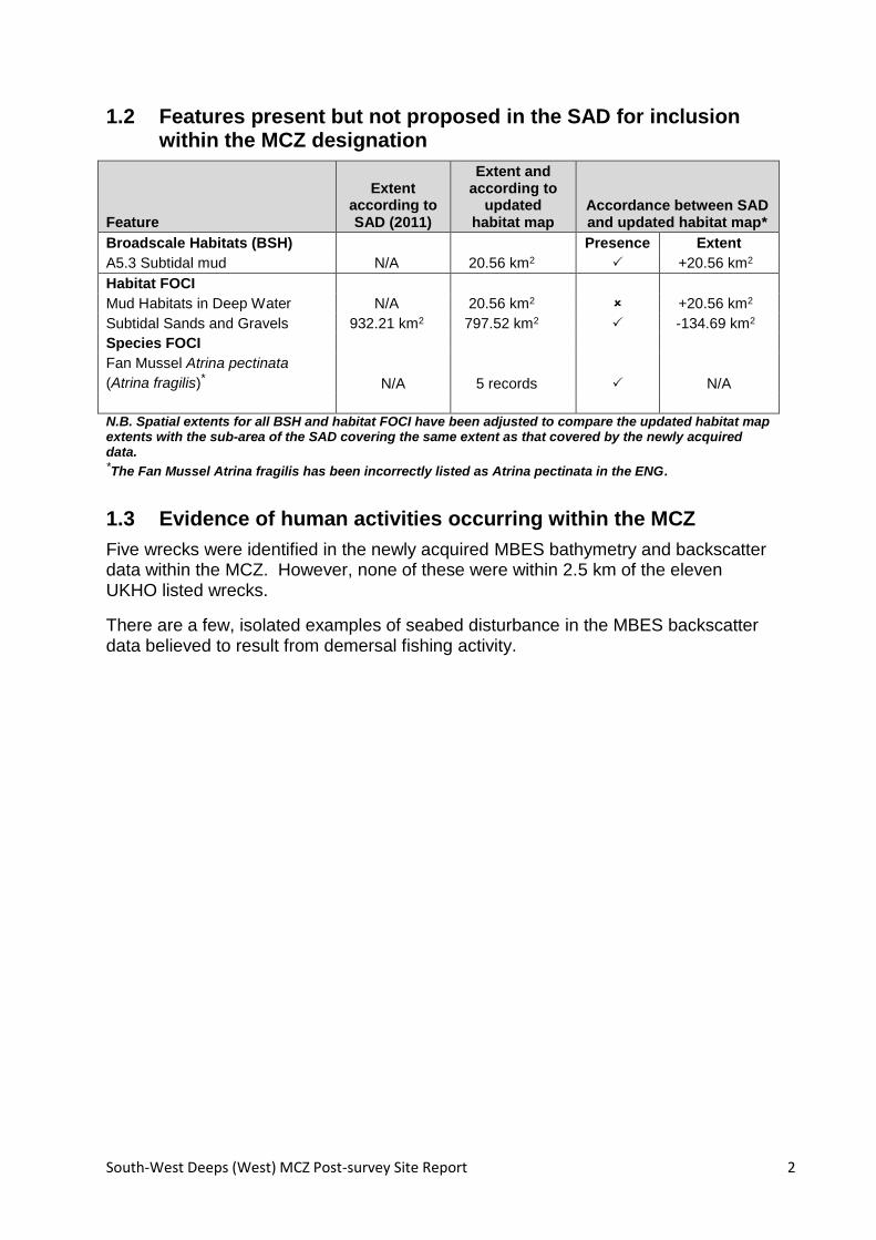
1.2 Features present but not proposed in the SAD for inclusion within the MCZ designation
Feature
Extent according to SAD (2011)
Extent and according to
updated habitat map
Accordance between SAD and updated habitat map*
Broadscale Habitats (BSH) Presence Extent
A5.3 Subtidal mud N/A 20.56 km2 +20.56 km2
Habitat FOCI
Mud Habitats in Deep Water N/A 20.56 km2 +20.56 km2
Subtidal Sands and Gravels 932.21 km2 797.52 km2 -134.69 km2
Species FOCI
Fan Mussel Atrina pectinata
(Atrina fragilis)* N/A 5 records N/A
N.B. Spatial extents for all BSH and habitat FOCI have been adjusted to compare the updated habitat map extents with the sub-area of the SAD covering the same extent as that covered by the newly acquired data. *The Fan Mussel Atrina fragilis has been incorrectly listed as Atrina pectinata in the ENG.
1.3 Evidence of human activities occurring within the MCZ
Five wrecks were identified in the newly acquired MBES bathymetry and backscatter data within the MCZ. However, none of these were within 2.5 km of the eleven UKHO listed wrecks.
There are a few, isolated examples of seabed disturbance in the MBES backscatter data believed to result from demersal fishing activity.

South-West Deeps (West) MCZ Post-survey Site Report 3
2 Introduction
In accordance with the Marine and Coastal Access Act 2009, the UK is committed to the development and implementation of a network of Marine Protected Areas (MPAs). The network will incorporate existing designated sites (e.g. Special Areas of Conservation and Special Protection Areas) along with a number of newly designated sites which, within the English territorial waters and offshore waters of England, Wales and Northern Ireland, will be termed Marine Conservation Zones (MCZs). The first 27 MCZs were designated in November 2013 and the list includes the South-West Deeps (West) MCZ (UKMO, 2013), which is the subject of this report.
In support of this initiative, four regional projects were set up to select sites that could contribute to this network because they contain one or more features specified in the Ecological Network Guidance (ENG; Natural England and the JNCC, 2010). The regional projects proposed a total of 127 recommended MCZs (rMCZs) and compiled a Site Assessment Document (SAD) for each site. The SAD summarises what evidence was available for the presence and extent of the various habitat, species and geological features specified in the ENG, and for which the site was being recommended.
Due to the scarcity of survey-derived seabed habitat maps in UK waters, these assessments were necessarily made using ‘best available evidence’, which included historical data, modelled habitat maps and stakeholder knowledge of the areas concerned.
It became apparent that the ‘best available evidence’ on features for which some sites had been recommended as MCZs was of variable quality. Consequently, Defra initiated a number of measures aimed at improving the evidence base, one of which took the form of a dedicated survey programme, implemented and co-ordinated by Cefas, to collect and interpret new survey data at selected rMCZ sites. This report provides an interpretation of the survey data collected Cefas and Gardline surveys at the South-West Deeps (West) MCZ site during 2013.

South-West Deeps (West) MCZ Post-survey Site Report 4
2.1 Location of the MCZ
The South-West Deeps (West) MCZ is located in the Celtic Sea, approximately 200 kilometres west-southwest of the Isles of Scilly (Figure 1).
Figure 1. Location of the South-West Deeps (West) MCZ. Bathymetry is from the BGS DiGMapGB (Reproduced with the permission of the British Geological Survey ©NERC. All rights Reserved)
2.2 Rationale for site position and designation
The South-West Deeps (West) MCZ was included in the proposed network because of its contribution to Ecological Network Guidance (ENG) criteria to broadscale habitats as well as its unique geological/geomorphological character i.e. Celtic Sea relict sandbanks. For a detailed site description see Lieberknecht et al. (2011) and ‘The Marine Conservation Zone Project: Ecological Network Guidance’ (Natural England and the JNCC, 2010).
2.2.1 Broadscale habitats proposed for designation
Three broadscale habitats were included in the recommendations for designation at this site: ‘A5.1 Subtidal coarse sediment’, ‘A 5.2 Subtidal sand’ and ‘A5.4 Subtidal mixed sediments’ (Table 1). The geomorphic features ‘Celtic Sea relict sandbanks’ are also included in the recommendations for this site. See Annex 1 for a full list of broadscale habitat features listed in the ENG.

South-West Deeps (West) MCZ Post-survey Site Report 5
Table 1. Broadscale habitats for which this MCZ was proposed for designation.
EUNIS code & Broadscale Habitat Spatial extent according to the SAD
A5.1: Subtidal coarse sediment 142.91 km2
A5.2: Subtidal sand 789.30 km2
A5.4: Subtidal mixed sediments 2.44 km2
N.B. Spatial extents for all BSH have been adjusted to compare the updated habitat map extents with the sub-area of the SAD covering the same extent as that covered by the newly acquired data.
2.2.2 Habitat FOCI proposed for designation
Annex 2 presents the habitat FOCI listed in the ENG. While ‘Subtidal Sands and Gravels’ are listed in the SAD, conservation objectives have not been proposed for this habitat FOCI as all conservation requirements are considered to be met by the listed broadscale habitats.
Table 2. Habitat FOCI for which this MCZ was proposed for designation.
Habitat FOCI Spatial extent according to SAD
None listed N/A
2.2.3 Species FOCI proposed for designation
Annexes 3 and 4 present the species FOCI listed in the ENG. No species FOCI are identified in the SAD.
Table 3. Species FOCI for which this MCZ was proposed for designation..
Species FOCI Spatial extent according to SAD
None Listed N/A
2.3 Rationale for prioritising this MCZ for additional evidence collection
Prioritisation of MCZ sites for further evidence collection was informed by a gap analysis and evidence assessment. The prime objective was to elevate the confidence status for as many MCZs as feasible to support designation in terms of the quantity and quality of evidence for the presence and extent of broadscale habitat features and habitat FOCI and, where possible, species FOCI. The confidence status was originally assessed in the SADs according to Technical Protocol E (Natural England and the JNCC, 2012).
The confidence score for the presence and extent of broadscale habitats and habitat FOCI reported for the South-West Deeps (West) rMCZ was considered Low-to-Moderate (Lieberknecht et al., 2011; JNCC and Natural England, 2012). This site was therefore prioritised for additional evidence collection.

South-West Deeps (West) MCZ Post-survey Site Report 6
2.4 Survey aims and objectives
Primary Objectives
To collect acoustic and groundtruthing data to allow the production of an updated seabed habitat map which could be used to inform the presence of broadscale habitats and habitat FOCI, and allow estimates to be made of their spatial extent within the MCZ.
Secondary Objectives
To provide evidence, where possible, of the presence of species FOCI listed within the ENG (Annexes 3 and 4) within the MCZ.
To report evidence of human activity occurring within the MCZ during the course of the survey.
It should be emphasised that surveys were not primarily designed to address the secondary objectives under the current programme of work.
Whilst the newly collected data will be utilised for the purposes of reporting against the primary objectives of the current programme of work (given above), it is recognised that these data will be valuable for informing the assessment and monitoring of condition of given habitat features in the future.

South-West Deeps (West) MCZ Post-survey Site Report 7
3 Methods
3.1 Acoustic data acquisition
New multibeam echosounder (MBES) bathymetry and backscatter data were acquired during two separate surveys conducted by Gardline and Cefas, for the purposes of mapping the MCZ area. The regional Gardline survey at the South-West Deeps (West) MCZ was carried out between 10th Feb–25th March, 2013 on MV Lespoir using a 100 kHz system (Lot 4) (Gardline, 2013). Full MBES coverage was not accomplished due to poor weather conditions on site (82% weather down time), and the survey was cancelled prior to completion, with approximately 50% of the MCZ area covered (Appendix 2). The Cefas survey was carried out between 8th–28th May, 2013 on RV Cefas Endeavour (Cruise code CEND0613; McIlwaine, 2013). The primary aim of this survey was to acquire groundtruthing (GT) data to be used in conjunction with the acoustic data acquired by Gardline. However the survey also included acquisition of MBES data (300 kHz system) from nested survey areas to assess specific features of interest.
For both surveys, CARIS HIPS was utilized to process the bathymetry data and Fledermaus Geocoder Toolkit (FMGT) was used to produce fully compensated and corrected backscatter mosaic and were exported as Floating Point Geotiff files for further analysis. For the regional Gardline survey, bathymetry data were gridded at 5 m resolution while the backscatter was gridded at 2 m. For the nested Cefas surveys, both the bathymetry and backscatter data were gridded at 2 m resolution (see Appendix 2 for bathymetry and backscatter images derived from the acoustic data).
On completion of the acoustic surveys, the processed MBES bathymetry and backscatter data were utilised to inform the positioning of ground truth sampling stations.
3.2 Ground truth sample acquisition
Of the two surveys of the MCZ area, only the RV Cefas Endeavour leg (8th-28th May, 2013) included the acquisition of groundtruthing data. Sample stations were chosen following review of the MBES data from the MV Lespoir leg (Appendix 1) (10th February-25th March, 2013). Groundtruthing was accomplished through acquisition of both physical sediment/biological samples as well through seabed imaging.
Within the MCZ area, 208 Hamon grab samples were acquired and sub-sampled for Particle Size Analysis (PSA) and processed for macrofauna. These included all planned sites as well as 10 additional sites acquired within the nested survey areas (Figure 2; McIlwaine, 2013). Complete sediment particle size analysis was conducted post cruise by Cefas scientists, and samples were classified into both Folk and EUNIS BSH classes. The 208 PSA samples have been subdivided into the following BSH classes: ‘A5.1 Subtidal coarse sediment’– 22 samples, ‘A5.2 Subtidal sand’– 161 samples, ‘A5.3 Subtidal mud’– 9 samples, and ‘A5.4 Subtidal mixed sediments’– 16 samples.
Further groundtruthing was accomplished through seabed imaging utilising a camera sledge (CS), where 74 stations were successfully imaged (McIlwaine, 2013). Video

South-West Deeps (West) MCZ Post-survey Site Report 8
observations were made with a camera sledge system comprising a rectangular frame fitted with a video camera with the capability to also capture still images (Figure 2). Illumination was provided by high intensity LED spotlights and a flash unit. The camera was fitted with a four-spot laser-scaling device to provide a reference scale in the video image. Set-up and operation followed the MESH ‘Recommended Operating Guidelines (ROG) for underwater video and photographic imaging techniques’.
Camera sledge deployments lasted a minimum of 10 minutes, with the vessel executing a controlled transit at ~0.5 knots (~0.25 m s-1) across the target site. Still images were captured at regular one minute intervals and opportunistically if specific features of interest were observed.
Video and still images were analysed by Envision Mapping Ltd. (2013) following an established protocol developed and used by Cefas (Coggan et al., 2007; JNCC, in prep.; see Annex 5). All still images were analysed. The time and position at which each still was taken was noted from the metadata provided. The physical and biological characteristics were viewed at normal and greater than normal magnification, noting details of substrate types and species present. A broadscale habitat type, habitat FOCI (if applicable) and biotope was then assigned to each still according to “The Marine Habitat Classification for Britain and Ireland Version 04.05”.
In total, 74 videos and 1148 still images were provided for analysis. Of the still images analysed, 12% were classified as ‘A5.1 Subtidal coarse sediment’, 58% as ‘A5.2 Subtidal sand’, and 30% as ‘A5.4 Subtidal mixed sediments’.

South-West Deeps (West) MCZ Post-survey Site Report 9
Figure 2. Location of ground truth sampling sites in the South-West Deeps (West) MCZ. Bathymetry displayed is from the BGS DiGMapGB (Reproduced with the permission of the British Geological Survey ©NERC. All rights Reserved).
3.3 Production of the updated habitat map
All new habitat maps and their derivatives have been based on a WGS84 datum. A new habitat map for the site was produced by analysing and interpreting the available acoustic data (as detailed above) and the ground truth data collected by the dedicated surveys of this site. The process is a combination of two approaches, auto-classification (image analysis) and expert interpretation, as described below. The routine for auto-classification is flexible and dependent on site-specific data, allowing for application of a bespoke routine to maximise the acoustic data available.
ArcGIS was used to perform an initial unsupervised classification on the supplied backscatter image. The single band backscatter mosaic was filtered and smoothed prior to the application of an Iso cluster/maximum likelihood classification routine. Python scripting language was used to automate the workflow. Each stage in the process is numbered and described in detail below.
Stage 1. Data Preparation
Prior to analysis, the bathymetry and backscatter data were re-sampled onto a common grid at 2 m resolution. This data preparation results in a spatial grid with a single value for bathymetry (depth) and a single value for backscatter (acoustic reflectance) in each 2 m by 2 m grid cell, and it is these data values that were used in the rest of the process.

South-West Deeps (West) MCZ Post-survey Site Report 10
Stage 2. Derivatives calculated
From the two primary acoustic datasets, bathymetry and backscatter, a range of derivatives were calculated, as detailed in Table 4.
Table 4. Description of derivatives calculated for bathymetry using ArcGIS/Fledermaus.
Derivative Description
Slope The slope in degrees using the maximum change in elevation of each cell and its 8 neighbours (3*3)
Roughness/Rugosity Calculated as the difference between the maximum and minimum value of each cell and its 8 neighbours (3*3)
Aspect Identifies the downslope direction of the maximum rate of change in value from each cell to its neighbours. It can be thought of as the slope direction.
Stage 3. Unsupervised Classification
The following steps outline the routine performed using standard ArcGIS functionality to automatically classify the single band backscatter mosaic. This functionality was accessed and performed using a single Python script.
Smoothing/generalisation of the backscatter image
The initial step involved the generalisation and smoothing of the single band backscatter mosaic prior to application of the classification tools, to remove the influence of noise and ‘striping’ from within the backscatter image. This makes the production of smooth, topologically correct, ‘realistic’ polygons easier for later modification and attribution during the manual phase.
The raster was down-sampled to a 20 m resolution. Focal statistics were used to populate the cell values of a new 3 m resolution grid based on the mean of a 3 x 3 neighbourhood. The focal statistic command was repeated up to 10 times to ensure a smooth, noise free grid, as illustrated in Figure 3. The initial coarse resolution ensures the removal of any striping whilst maintaining the general trend. Converting back to a finer resolution is essential for the production of smooth, realistic vector output. The choice of cell size combination is crucial in determining feature size to be preserved. The cell size is chosen after consultation with the mapping geologist regarding the most appropriate scale of mapping in order to maximise the removal of noise from the data set, whilst preserving the required feature visibility.

South-West Deeps (West) MCZ Post-survey Site Report 11
Original Image
Resample to 20 m
FocalStats back to 3 m
FocalStats *10
Figure 3. Backscatter mosaic generalisation/smoothing prior to autoclassification routine.
ArcGIS Iso Cluster Unsupervised Classification Tool
This tool is part of the classification toolset available on the image classification toolbar within ArcGIS 10.1. The Iso cluster tool was chosen as it produced the best results from the single band image of backscatter intensity. The tool uses an iterative clustering procedure, also known as a migrating means technique, to find the natural groupings of cells and produce a signature file to be used as an input requirement for the maximum likelihood tool. The user chooses an unrealistically high number of potential sediment classes to group each cell into. The algorithm separates each cell into one of these clusters/groupings by calculating an arbitrary mean for each and assigning a cell to the most suitable cluster based on the shortest Euclidean distance. The mean of each group is then recalculated based on this first reiteration of groupings. The process is repeated for the number of iterations specified, which should be greater than the number of classes and enough to ensure that the movement of cells across classes has become stable.
The maximum likelihood classification tool uses the output signature file from the Iso cluster procedure to create a classified raster. The tool will consider the variance and co-variance of the class signature when assigning each cell to one of the classes. With the assumption that the distribution of a class sample is normal, a class can be characterised by the mean vector and the covariance matrix. The statistical probability is computed for each class to determine the membership of

South-West Deeps (West) MCZ Post-survey Site Report 12
cells to a class. An a priori probability weighting option is the default value of the maximum likelihood routine, whereby each cell is assigned to the class to which it has the highest probability of being a member.
Raster to polygon to conversion
The classified raster obtained from the above steps is converted to a vector polygon shapefile to produce a final fully attributed, topologically clean, smooth vector dataset (Figure 4).
Result of FocalStats/ Generalising
Iso Cluster Tool
Raster to Polygon
Figure 4. Iso cluster maximum likelihood classification routine.
The resultant classified output represents a numeric, thematic map. The number of classes created is simply an over-estimation of the potential number of sediment types present in the study area. The user can analyse the resulting map and change the number of classes until satisfied all likely changes in seabed substrate have been represented.
Stage 4. Expert Judgement
The vectorised output of the semi-automated process is reviewed manually to assign sedimentological classifications in accordance with the EUNIS habitat classification system. An appreciation of the geological characteristics of the area also means that the expert involved can ‘sense check’ the outputs. Polygons can be amended, modified and merged to best represent the acoustic data, groundtruthing samples with the influence of geological judgement.
In this case, final mapped boundaries between rock and sediment substrate classes are dependent on assessing the bathymetry, backscatter, and derived products together with the groundtruthing data, as the backscatter data alone, on which the semi-automated classification is conducted, does not provide a unique correlation between backscatter amplitude and sediment class.
As confirmed by the grab samples, high backscatter intensities indicate gravel percentages of greater than 5%, indicating either ‘coarse’ or ‘mixed’ sediments. Groundtruthing results were then used to sub-divide areas of high backscatter into the ‘coarse’ or ‘mixed’ sediment classes. Taking into account that the PSA data from Hamon grabs provide a more quantitative assessment of sediment fractions than that of the video/still image analysis, as well as the fact that some of the video/still image data were judged to be moderate to poor in quality (Envision, 2013), the PSA

South-West Deeps (West) MCZ Post-survey Site Report 13
data were used as the primary groundtruthing dataset for purposes of mapping broadscale habitats and habitat FOCI.
Vectorised outputs from the semi-automated process were manually modified where appropriate, and features smaller than 100 m² were removed as they frequently resulted from spurious data, and were not sufficiently useful for the relevant scale of assessment. Mismatches between the unsupervised classification of the regional (Gardline) and nested (Cefas) surveys required adjustment in places. Manual editing was conducted to harmonise the separate survey areas into a single interpretation. It does not appear that these mismatches result from limitations in the semi-automated method, but more likely result from the variance in the acquired data. There was no predictable pattern where mismatching occurred e.g. a nested survey in one area may exhibit higher backscatter intensity relative to the regional survey, while further down the line the opposite is the case, or there is very good alignment. Also, while not expected to be significant, some change in sediment distribution could have occurred between the February/March regional survey, and the May nested surveys. This issue illustrates the difficulties in normalising backscatter outputs.
3.4 Quality of the updated map
The technical quality of the updated habitat map was assessed using the MESH ‘Confidence Assessment’ Tool1, originally developed by an international consortium of marine scientists working on the MESH (Mapping European Seabed Habitats) project. This tool considers the provenance of the data used to make a biotope/habitat map, including the techniques and technology used to characterise the physical and biological environment and the expertise of the people who had made the map. In its original implementation, it was used to make an auditable judgement of the confidence that could be placed in a range of existing, local biotope maps, that had been developed using different techniques and data inputs, but were to be used in compiling a full coverage map for north-west Europe. Where two of the original maps overlapped, that with the highest MESH confidence score would take precedence in the compiled map.
Subsequent to the MESH project, the confidence assessment tool has been applied to provide a benchmark score that reflects the technical quality of newly developed habitat/biotope maps. Both physical and biological survey data are required to achieve the top mark of 100, but as the current MCZ exercise requires the mapping of broadscale physical habitats, not biotopes, it excludes the need for biological data. In the absence of biological data, the maximum score attainable for a purely physical habitat map is 88.
In applying the tool to the current work, none of the weighting options were altered; that is, the tool was applied in its standard form, as downloaded from the internet.
1 http://www.searchmesh.net/confidence/confidenceAssessment.html [Accessed 06/03/2014]

South-West Deeps (West) MCZ Post-survey Site Report 14
4 Results
4.1 Site Assessment Document (SAD) habitat map
The SAD habitat map (Figure 5) was produced using modelled data from the UKSeaMap (McBreen, 2010). For further detail see Lieberknecht et al. (2011).
Figure 5. Habitat map from the Site Assessment Document.
4.2 Updated habitat map based on new survey data
The updated habitat map resulting from an integrated analysis of the 2013 dedicated survey data is presented in Figure 6.
The list of benthic taxa found in the video samples is presented in Appendix 4; a total of 386 infaunal and 56 epifaunal taxa were recorded.
The list includes the Fan Mussel Atrina fragilis, one of the species FOCI listed in the ENG. It should be noted that this species has been incorrectly listed as Atrina pectinata in the ENG.
The analysis of the seabed video and stills is summarised in Appendix 5. Example images of the BSHs and habitat FOCI recorded in the video analysis are provided in Appendix 6 and 7 respectively.

South-West Deeps (West) MCZ Post-survey Site Report 15
Figure 6. Updated map of broadscale habitats based on newly acquired survey data.

South-West Deeps (West) MCZ Post-survey Site Report 16
4.3 Quality of the updated habitat map
This map attained a score of 83 from the MESH Confidence Assessment Tool (Figure 7), which is considered to be good, given that the maximum possible score for a purely physical habitat map is 88.
Figure 7. Overall MESH confidence score for the updated broadscale habitat map.
4.4 Broadscale habitats identified
‘A5.2 Subtidal sand’ was the most widespread habitat type, occupying 78% of the MCZ area (Figure 6; Table 4). ‘A5.1 Subtidal coarse sediment’ occupies 8%, ‘A5.4 Subtidal mixed sediments’ occupies 12%, and ‘A5.3 Subtidal mud’ occupies 2% of the MCZ area.
Seabed geomorphology within the MCZ area is characterized on the large scale (Length: 10’s of kilometres; Relief: up to 25 m within the MCZ area) by the presence of several NNE/SSW trending sediment ridges i.e. the ‘Celtic Sea Ridges’ (Appendix 2). At the medium scale (Length: 100 m–5 km; Relief: up to 10m ) we observe NW/SE trending broad, rounded-off apparently moribund sediment ridges, as well as sharper crested, apparently active, sand waves along a similar trend. The active sandwaves, as revealed by the backscatter intensity and groundtruthing results, are almost always composed of sand. Where the surface veneer of mobile sand is absent, as indicated on the bathymetry and backscatter data, the large NNE/SSW Celtic Sea Ridges and the NW/SE broad, moribund ridges are more frequently associated with coarser sediments, i.e. ‘A5.1 Subtidal coarse sediment’ and ‘A5.4 Subtidal mixed sediments’.

South-West Deeps (West) MCZ Post-survey Site Report 17
Within the MCZ area there is a challenge in discriminating between ‘A5.1 Subtidal coarse sediment’ and ‘A5.4 Subtidal mixed sediments’, as both exhibit similar backscatter intensities. For this reason, the groundtruthing results were essential to attribute these areas accurately. Also, mobile sediment waves indicate local bottom current directions. Across the survey area, some sediment waves indicate currents heading predominantly towards the south (~northern MCZ area), while others indicate a more northerly flow (~southern MCZ area). Together these suggest a moderately complex hydrodynamic regime. As would be expected, several groundtruthing stations reveal the stoss (upstream) slope of local bathymetric highs to comprise ‘A5.1 Coarse sediment’ where the seabed is exposed to higher bed-stress, while the lee (downstream) slopes comprise ‘A5.4 Subtidal mixed sediments’, where lower bed-stress allows for deposition and/or preservation of finer sediment. Where possible, and near boundaries between coarse/mixed, this observation has been used to discriminate between the two classes where only acoustic data are available.
A notable observation of the seabed sediments in the region is the high proportion of coarse sediment fractions (‘A5.1 Subtidal coarse sediment’ and ‘A5.4 Subtidal mixed sediments’) found within the MCZ area. The source of these coarse sediments is likely glacial. While the conventional hypothesis is that the Celtic Sea Ridges (Appendix 2) formed during the marine transgression of the shelf following the Last Glacial Maximum (LGM - 21 kya) (e.g. Scourse et al., 2009), there are alternative models suggesting the ridges may have formed sub-glacially (Praeg et al., 2013). Either way, it is clear that glacially derived coarse sediments have been transported to the MCZ area. It is not yet clear whether the association with the ridges is due to their comprising higher proportions of coarse sediment, or simply because they experience relatively higher bed-stress, thus causing finer sediments to be winnowed away.
A distinction between the SAD habitat map (Figure 5), and the updated habitat map (Figure 6) is the occurrence of ‘A5.3 Subtidal mud’ in the north of the MCZ area, which is confirmed by multiple groundtruthing stations. It is also a challenge to discriminate between ‘A5.2 Subtidal sand’ and ‘A5.3 Subtidal mud’ using the acoustic data alone, and again the groundtruthing data were crucial for defining boundaries between the two sediment types. There is also a clear trend on the large scale, of decreasing mud fractions in the groundtruthing data, moving from northeast to southwest. An exception to this is the large NNE/SSW oriented ridge bisecting the middle of the MCZ area, which comprises coarse sediment.
Table 5. Broadscale habitats identified in this MCZ.
Broadscale Habitat Type (EUNIS Level 3)
Spatial extent according to the SAD
Spatial extent according to the updated habitat map
A5.1 Subtidal coarse sediment 142.91 km2 72.84 km2
A5.2 Subtidal sand 789.30 km2 724.68 km2
A5.3 Subtidal mud N/A 20.56 km2
A5.4 Subtidal mixed sediments 2.44 km2 110.73 km2
N.B. Spatial extents for all BSH have been adjusted to compare the updated habitat map extents with the sub-area of the SAD covering the same extent as that covered by the newly acquired data.

South-West Deeps (West) MCZ Post-survey Site Report 18
4.5 Habitat FOCI identified
The SAD estimates that approximately 99% of the MCZ area is covered by the ‘Subtidal Sands and Gravels’ habitat FOCI. The 2013 dedicated survey and interpretation reveal ‘Subtidal Sands and Gravels’ covers 797.52 km2, however conservation objectives have not been included for this feature as all conservation requirements are considered to be met by the listed broadscale habitats.
The 2013 survey of South-West Deeps (West) MCZ identified one other habitat FOCI, ‘Mud Habitats in Deep Water’. Of the area surveyed, ‘Mud Habitats in Deep Water’ covers 20.56 km2, in a patch situated close to the northernmost corner of the MCZ (Table 6; Figure 8).
Figure 8. Habitat FOCI identified.
Table 6. Habitat FOCI identified in this MCZ.
Habitat FOCI Spatial extent according to
the SAD Spatial extent according to
the updated habitat map
Mud Habitats in Deep Water N/A 20.56 km2
Subtidal Sands and Gravels 932.21 km2 797.52 km2
N.B. Spatial extents for the Habitat FOCI have been adjusted to compare the updated habitat map extents with the sub-area of the SAD covering the same extent as that covered by the newly acquired data.

South-West Deeps (West) MCZ Post-survey Site Report 19
4.6 Species FOCI identified
The species FOCI ‘Fan Mussel Atrina fragilis’ was identified in three of the grabs samples and two video samples collected during the 2013 groundtruthing survey carried out by Cefas. It should be noted that the Fan Mussel Atrina fragilis has been incorrectly listed as Atrina pectinata in the ENG.
Table 7. Species FOCI identified in this MCZ.
Species FOCI Previously recorded within
MCZ Identified during evidence
gathering survey
Fan Mussel Atrina fragilis* N/A 5 Records
* The species FOCI ‘Fan Mussel Atrina fragilis’ has been incorrectly listed in the ENG as Atrina pectinata (see Annex 3).
Figure 9. Distribution of stations where the species FOCI Fan Mussel Atrina fragilis was recorded.
4.7 Quality Assurance (QA) and Quality Control (QC)
4.7.1 Acoustic data
The acoustic data utilised for production of the updated habitat map were collected by RV CEFAS Endeavour and Gardline’s MV Lespoir. The accompanying MBES backscatter data were reviewed and processed by specialist BGS and Cefas staff to ensure that these data were suitable for use in the subsequent interpretations and production of the updated habitat map.

South-West Deeps (West) MCZ Post-survey Site Report 20
4.7.2 Video and still images and analysis
Video and photographic stills were processed by Envision (Envision, 2013) in accordance with the guidance documents developed by Cefas and the JNCC for the acquisition and processing of video and stills data (Coggan and Howell, 2005; JNCC, in prep.; summarised in Annex 5).
4.8 Data limitations and adequacy of the updated habitat map
The quality of the derived habitat map is assessed to be High (MESH assessment tool). A source of potential misclassification of habitats arises from the location of groundtruthing samples (seabed camera) in relation to habitat types.
The survey has provided substantial, robust evidence for the presence of the mapped habitats. However, as it is impractical (and undesirable) to sample the entire area of the site with grabs and video, there is a chance that a BSH or FOCI may exist within the site but has not been recorded, especially if it was limited in spatial extent.
The precise location of the boundaries between the broadscale habitats depicted on the map should be regarded as indicative, not definitive. In nature, such boundaries are rarely abrupt. Instead it is typical for one BSH to grade into another across a transitional boundary. In contrast, the mapped boundaries are abrupt and have been placed using best professional judgment. This may have implications when calculating the overall extent of any of the mapped habitats or FOCI.
4.9 Observations of human impacts on the seabed
There are 11 listed wrecks within the MCZ area, however only four of these listed locations were located in areas covered by acoustic surveys (Appendix 3).
Within the MCZ area, 5 seabed anomalies were observed, thought to be wrecks (between 85 m and 160 m in length), though none are within 2.5 km of the UKHO listed wreck locations (Appendix 3).
The MBES (primarily backscatter) data also reveal a few isolated examples of trawl scars on the seabed believed to result from demersal fishing activity within the area (Appendix 3).

South-West Deeps (West) MCZ Post-survey Site Report 21
5 Conclusions
5.1 Presence and extent of broadscale habitats
5.1.1 Presence
The 2013 dedicated surveys confirmed the presence of the ‘A5.1 Subtidal coarse sediment’, ‘A5.2 Subtidal sand’, and ‘A5.4 Subtidal mixed sediments’ broadscale habitats that were included in the recommendations made by the SAD for designating this site as an MCZ. ‘A5.3 Subtidal mud’ was also identified, though not predicted to be present by the SAD.
The partial extent of three Celtic Sea relict sandbanks within the MCZ was also surveyed during the 2013 surveys.
5.1.2 Extent
Due to poor weather conditions during the 2013 surveys, only 51% of the MCZ area was surveyed with MBES, on which BSH interpretations are primarily based. Therefore, spatial extents for all BSH have been adjusted to compare the updated habitat map extents with the sub-area of the SAD covering the same extent as that covered by the newly acquired data.
The spatial extent of the ‘A5.1 Subtidal coarse sediment’ BSH on the updated habitat map is 72.84 km2. This is 70.07 km2 less than its spatial extent in the SAD habitat map which has been adjusted to the same area as that covered by the newly acquired survey data.
The spatial extent of the ‘A5.2 Subtidal sand’ BSH on the updated habitat map is 724.68 km2. This is 64.62 km2 less than its spatial extent in the SAD habitat map which has been adjusted to the same area as that covered by the newly acquired survey data.
The spatial extent of the ‘A5.3 Subtidal mud’ BSH on the updated habitat map is 20.56 km2. This is 20.56 km2 more than its spatial extent in the SAD habitat map, where it is not predicted to occur.
The spatial extent of the ‘A5.4 Subtidal mixed sediments’ BSH on the updated habitat map is 110.73 km2. This is 108.29 km2 more than its spatial extent in the SAD habitat map which has been adjusted to the same area as that covered by the newly acquired survey data.
5.2 Presence and extent of habitat FOCI
5.2.1 Presence
The 2013 dedicated survey identified the presence of the habitat FOCI ‘Mud Habitats in Deep Water’, however this habitat FOCI was not listed in the SAD for designation of this MCZ.

South-West Deeps (West) MCZ Post-survey Site Report 22
The 2013 dedicated survey identified the presence of the habitat FOCI ‘Subtidal Sands and Gravels’ which was listed in the SAD but not included in the recommendations for designation.
5.2.2 Extent and distribution
The extent of the ‘Mud Habitats in Deep Water’ habitat FOCI surveyed in the 2013 dedicated survey was 20.56 km2.
The extent of the ‘Subtidal Sands and Gravels’ habitat FOCI surveyed in the 2013 dedicated survey was 797.52 km2.
5.3 Presence and distribution of species FOCI
5.3.1 Low or limited mobility species
The species FOCI ‘Fan Mussel Atrina fragilis’ (incorrectly listed as Atrina pectinata in the ENG), has been recorded from three grab samples and two video sample collected from within this site during the May 2013 survey.
No highly mobile species FOCI were recorded at this site by the 2013 dedicated surveys. These observations are consistent with the evidence presented in the SAD.
5.4 Evidence of human activities impacting the seabed
Using the MBES bathymetry and backscatter as evidence, five wrecks were identified within the MCZ area, though none of these were within 2.5 km of the eleven UKHO listed wrecks.
There are a few, isolated examples of seabed disturbance in the MBES backscatter data believed to result from demersal fishing activity.

South-West Deeps (West) MCZ Post-survey Site Report 23
References
Coggan, R., Mitchell, A., White, J. and Golding, N. (2007). Recommended operating guidelines (ROG) for underwater video and photographic imaging techniques (www.searchmesh.net/PDF/GMHM3_video_ROG.pdf) [Accessed 06/03/2014]
Coggan, R. and Howell, K. (2005). Draft SOP for the collection and analysis of video and still images for groundtruthing an acoustic basemap. Video survey SOP version 5. 10 pp.
Envision (2013). Video Analysis Report: SWDW South-West Deeps (West). Prepared for CEFAS by Envision Mapping Ltd. 16 pp.
Gardline (2013). South-West Deeps (West) Cruise Report. Gardline Geosurvey. 294 pp.
JNCC (in prep.). Video/Stills Camera Standard Operating Procedure for Survey and Analysis: for groundtruthing and classifying an acoustic basemap, and development of new biotopes within the UK Marine Habitat Classification. JNCC Video and Stills Processing SOP v2. 6 pp.
Lieberknecht, L.M., Hooper, T.E.J., Mullier, T.M., Murphy, A., Neilly, M., Carr, H., Haines, R., Lewin, S. and Hughes, E. (2011). Finding Sanctuary final report and recommendations. A report submitted by the Finding Sanctuary stakeholder project to Defra, the Joint Nature Conservation Committee, and Natural England. Available at http://findingsanctuary.marinemapping.com/ [Accessed 16/05/2014]
McBreen, F. (2010). UKSeaMap 2010 EUNIS model Version 3.0. UKSeaMap 2010: Predictive seabed habitat map (v5). JNCC.
McIlwaine, P. (2013). South-West Deeps (West) recommended Marine Conservation Zone (MCZ) Survey Report. Project Code: CEND06013, Cefas.
Natural England and the Joint Nature Conservation Committee (2010). The Marine Conservation Zone Project: Ecological Network Guidance. Sheffield and Peterborough, UK.
Natural England and the Joint Nature Conservation Committee (2012). SNCB MCZ Advice Project-Assessing the scientific confidence in the presence and extent of features in recommended Marine Conservation Zones (Technical Protocol E)
Praeg, D., McCarrron, S., Dove, D., Accettella, D., Clarke, C., Cova, A., Romeo, R. and Scott, G. (2013). Submarine glacial geomorphology of the Irish-UK Celtic Sea: results from the GLAMAR and GATEWAYS campaigns. In EGU General Assembly Conference Abstracts 15, p. 10943.
Scourse, J., Uehara, K. and Wainwright, A. (2009). Celtic Sea linear tidal sand ridges, the Irish Sea Ice Stream and the Fleuve Manche: palaeotidal modelling of a transitional passive margin depositional system. Marine Geology 259, 102-111.

South-West Deeps (West) MCZ Post-survey Site Report 24
UKMO (2013). United Kingdom Ministerial Order 2013 No. 21. Wildlife Environmental Protection Marine Management: The South-West Deeps (West) Marine Conservation Zone Designation Order. Made 21st November 2013; Coming into force 12th December 2013. http://www.legislation.gov.uk/ukmo/2013/21/contents/created [Accessed 16/05/2014].

South-West Deeps (West) MCZ Post-survey Site Report 25
Data sources
All enquiries in relation to this report should be addressed to following e-mail address: [email protected]

South-West Deeps (West) MCZ Post-survey Site Report 26
Annexes
Annex 1. Broadscale habitat features listed in the ENG.
Broadscale Habitat Type EUNIS Level 3 Code
High energy intertidal rock A1.1
Moderate energy intertidal rock A1.2
Low energy intertidal rock A1.3
Intertidal coarse sediment A2.1
Intertidal sand and muddy sand A2.2
Intertidal mud A2.3
Intertidal mixed sediments A2.4
Coastal saltmarshes and saline reed beds A2.5
Intertidal sediments dominated by aquatic angiosperms A2.6
Intertidal biogenic reefs A2.7
High energy infralittoral rock* A3.1
Moderate energy infralittoral rock* A3.2
Low energy infralittoral rock* A3.3
High energy circalittoral rock** A4.1
Moderate energy circalittoral rock** A4.2
Low energy circalittoral rock** A4.3
Subtidal coarse sediment A5.1
Subtidal sand A5.2
Subtidal mud A5.3
Subtidal mixed sediments A5.4
Subtidal macrophyte-dominated sediment A5.5
Subtidal biogenic reef A5.6
Deep-sea bed*** A6
* Infralittoral rock includes habitats of bedrock, boulders and cobble which occur in the shallow subtidal zone and typically support seaweed communities ** Circalittoral rock is characterised by animal dominated communities, rather than seaweed dominated communities *** The deep seabed broadscale habitat encompasses several different habitat sub-types, all of which should be protected within the MPA network. The broadscale habitat deep seabed habitat is found only in the south-west of the MCZ project area and MCZs identified for this broadscale habitat should seek to protect the variety of sub-types known to occur in the region.

South-West Deeps (West) MCZ Post-survey Site Report 27
Annex 2. Habitat FOCI listed in the ENG.
Habitat Features of Conservation Importance (FOCI)
Blue Mussel Beds (including Intertidal Beds on Mixed and Sandy Sediments)**
Cold-Water Coral Reefs ***
Coral Gardens***
Deep-Sea Sponge Aggregations***
Estuarine Rocky Habitats
File Shell Beds***
Fragile Sponge and Anthozoan Communities on Subtidal Rocky Habitats
Intertidal Underboulder Communities
Littoral Chalk Communities
Maerl Beds
Horse Mussel (Modiolus modiolus) Beds
Mud Habitats in Deep Water
Sea-Pen and Burrowing Megafauna Communities
Native Oyster (Ostrea edulis) Beds
Peat and Clay Exposures
Honeycomb Worm (Sabellaria alveolata) Reefs
Ross Worm (Sabellaria spinulosa) Reefs
Seagrass Beds
Sheltered Muddy Gravels
Subtidal Chalk
Subtidal Sands and Gravels
Tide-Swept Channels
* Habitat FOCI have been identified from the ‘OSPAR List of Threatened and/or Declining Species and Habitats’ and the ‘UK List of Priority Species and Habitats (UK BAP)’. ** Only includes ‘natural’ beds on a variety of sediment types. Excludes artificially created mussel beds and those which occur on rocks and boulders. *** Cold-Water Coral Reefs, Coral Gardens, Deep-Sea Sponge Aggregations and File Shell Beds currently do not have distributional data which demonstrate their presence within the MCZ project area.

South-West Deeps (West) MCZ Post-survey Site Report 28
Annex 3. Low or limited mobility species FOCI listed in the ENG.
Group Scientific name Common Name
Brown Algae Padina pavonica Peacock’s Tail
Red Algae Cruoria cruoriaeformis
Grateloupia montagnei
Lithothamnion corallioides
Phymatolithon calcareum
Burgundy Maerl Paint Weed
Grateloup’s Little-Lobed Weed
Coral Maerl
Common Maerl
Annelida Alkmaria romijni**
Armandia cirrhosa**
Tentacled Lagoon-Worm**
Lagoon Sandworm**
Teleostei Gobius cobitis
Gobius couchi
Hippocampus guttulatus
Hippocampus hippocampus
Giant Goby
Couch’s Goby
Long Snouted Seahorse
Short Snouted Seahorse
Bryozoa Victorella pavida Trembling Sea Mat
Cnidaria Amphianthus dohrnii
Eunicella verrucosa
Haliclystus auricula
Leptosammia pruvoti
Lucernariopsis campanulata
Lucernariopsis cruxmelitensis
Nematostella vectensis
Sea-Fan Anemone
Pink Sea-Fan
Stalked Jellyfish
Sunset Cup Coral
Stalked Jellyfish
Stalked Jellyfish
Starlet Sea Anemone
Crustacea Gammarus insensibilis**
Gitanopsis bispinosa
Pollicipes pollicipes
Palinurus elephas
Lagoon Sand Shrimp**
Amphipod Shrimp
Gooseneck Barnacle
Spiny Lobster
Mollusca Arctica islandica
Atrina pectinata
Caecum armoricum**
Ostrea edulis
Paludinella littorina
Tenellia adspersa**
Ocean Quahog
Fan Mussel
Defolin’s Lagoon Snail**
Native Oyster
Sea Snail
Lagoon Sea Slug**
* Species FOCI have been identified from the ‘OSPAR List of Threatened and/or Declining Species and Habitats’, the ‘UK List of Priority Species and Habitats (UK BAP)’ and Schedule 5 of the Wildlife and Countryside Act. ** Those lagoonal species FOCI may be afforded sufficient protection through coastal lagoons designated as SACs under the EC Habitats Directive. However, this needs to be assessed by individual regional projects.

South-West Deeps (West) MCZ Post-survey Site Report 29
Annex 4. Highly mobile species FOCI listed in the ENG.
Group Scientific name Common Name
Teleostei Osmerus eperlanus
Anguilla anguilla
Smelt
European Eel
Elasmobranchii Raja undulata Undulate Ray
* Species FOCI have been identified from the ‘OSPAR List of Threatened and/or Declining Species and Habitats’, the ‘UK List of Priority Species and Habitats (UK BAP)’ and Schedule 5 of the Wildlife and Countryside Act.

South-West Deeps (West) MCZ Post-survey Site Report 30
Annex 5. Video and stills processing protocol.
The purpose of the analysis of the video and still images is to identify what habitats exist in a video record, provide semi-quantitative data on their physical and biological characteristics and to note where one habitat changes to another. A minimum of 10% of the videos should be re-analysed for QA purposes.
Video Analysis
The video record is initially viewed rapidly (at approximately 4x normal speed) in order to segment it into sections representing different habitats. The start and end points of each segment are logged, and each segment subsequently subject to more detailed analysis. Brief changes in habitat type lasting less than one minute of the video record are considered as incidental patches and are not logged.
For each segment, note the start and end time and position from the information on the video overlay. View the segment at normal or slower than normal speed, noting the physical and biological characteristics, such as substrate type, seabed character, species and life forms present. For each taxon record an actual abundance (where feasible) or a semi quantitative abundance (e.g. SACFOR scale).
Record the analyses on the video pro-forma provided (paper and/or electronic), which is a modified version of the Sublittoral Habitat Recording Form used in the MNCR surveys.
When each segment has been analysed, review the information recorded and assign the segment to one of the broadscale habitat (BSH) types or Habitat FOCI listed in the Ecological Network Guidance (as reproduced in Annexes 1 and 2 above). Note also any species FOCI observed (as per Annex 3 above).
Stills analysis
Still images should be analysed separately, to supplement and validate the video analysis, and provide more detailed (i.e. higher resolution) information than can be extracted from a moving video image.
For each segment of video, select three still images that are representative of the BSH or FOCI to which the video segment has been assigned. For each image, note the time and position it was taken, using information from the associated video overlay.
View the image at normal or greater than normal magnification, noting the physical and biological characteristics, such as substrate type, seabed character, species and life forms present. For each taxon record an actual abundance (where feasible) or a semi quantitative abundance (e.g. SACFOR scale).
Record the analysis on the stills pro-forma provided (paper and/or electronic), which is a modified version of the Sublittoral Habitat Recording Form used in the MNCR surveys. Assign each still image to the same BSH or Habitat FOCI as its ‘parent’ segment in the video.

South-West Deeps (West) MCZ Post-survey Site Report 31
Taxon identification
In all analyses, the identification of taxa should be limited to a level that can be confidently achieved from the available image. Hence, taxon identity could range from the ‘life form’ level (e.g. sponge, hydroid, anemone) to the species level (e.g. Asterias rubens, Alcyonium digitatum). Avoid the temptation to guess the species identity if it cannot be determined positively from the image. For example, Pomatoceros sp. would be acceptable, but Pomatoceros triqueter would not, as the specific identification normally requires the specimen to be inspected under a microscope.

South-West Deeps (West) MCZ Post-survey Site Report 32
Appendices
Appendix 1. Survey metadata (CEND 06/13)
*All positions referenced to side gantry steer point.
Date sampled
Time sampled
Station code
Station number
Gear code Fix number
Latitude (degrees)
Longitude (degrees)
10/05/2013 10:39 S024 1 HG 1 49.48835 -9.03528
10/05/2013 12:25 S023 2 HG 2 49.46643 -9.00172
10/05/2013 12:54 GT37 3 HG 3 49.46098 -9.04334
10/05/2013 13:57 S022 5 HG 20 49.44411 -8.96995
10/05/2013 15:25 S021 7 HG 34 49.43361 -9.02108
10/05/2013 17:08 S025 8 HG 36 49.42345 -8.93725
10/05/2013 18:06 S020 9 HG 39 49.41209 -8.98855
10/05/2013 18:48 S012 10 HG 40 49.40154 -9.04018
10/05/2013 20:03 S011 12 HG 57 49.38049 -9.00529
10/05/2013 20:47 GT40 13 HG 58 49.39750 -8.94628
10/05/2013 23:16 S026 16 HG 75 49.40157 -8.90406
10/05/2013 23:55 S027 17 HG 76 49.38036 -8.87076
11/05/2013 02:29 C02 20 HG 92 49.35976 -8.97228
11/05/2013 03:49 GT36 22 HG 104 49.35384 -9.01469
11/05/2013 04:57 S098 23 HG 105 49.29508 -9.14404
11/05/2013 05:35 S104 24 HG 106 49.30552 -9.09212
11/05/2013 07:02 S108 26 HG 119 49.31618 -9.04215
11/05/2013 07:42 S113 27 HG 120 49.32706 -8.99171
11/05/2013 09:07 C01 29 HG 136 49.33705 -8.94039
11/05/2013 09:48 S018 30 HG 138 49.34840 -8.88993
11/05/2013 11:54 S028 32 HG 152 49.35803 -8.84027
11/05/2013 12:23 GT41 33 HG 153 49.33416 -8.84933
11/05/2013 13:37 S118 35 HG 167 49.31614 -8.90852
11/05/2013 14:11 S112 36 HG 168 49.30481 -8.95964
11/05/2013 15:24 S107 38 HG 182 49.29465 -9.01105
11/05/2013 16:46 S103 39 HG 183 49.28333 -9.06141
11/05/2013 18:03 S097 41 HG TargetS097 49.27222 -9.11182
11/05/2013 18:57 S092 42 HG 200 49.26161 -9.16131
11/05/2013 20:20 S084 43 HG 203 49.22926 -9.18221
11/05/2013 21:46 S091 45 HG 216 49.23947 -9.13088
11/05/2013 22:27 S096 46 HG 217 49.25133 -9.07975
12/05/2013 00:04 S102 48 HG 233 49.27203 -9.04550
12/05/2013 00:30 S101 49 HG 234 49.26203 -9.02908
12/05/2013 01:05 S106 50 HG 235 49.27338 -8.97794
12/05/2013 02:26 GT38 52 HG 241 49.26862 -8.95245
12/05/2013 03:04 GT39 53 HG 243 49.29065 -8.91786
12/05/2013 04:24 S117 55 HG 256 49.29491 -8.87487

South-West Deeps (West) MCZ Post-survey Site Report 33
Date sampled
Time sampled
Station code
Station number
Gear code Fix number
Latitude (degrees)
Longitude (degrees)
12/05/2013 04:59 S017 56 HG 257 49.30535 -8.82482
12/05/2013 05:40 S013 57 HG 258 49.28339 -8.79160
12/05/2013 07:15 S109 59 HG 273 49.27100 -8.84060
12/05/2013 07:57 S110 60 HG 274 49.26258 -8.89406
12/05/2013 08:36 S105 61 HG 275 49.25114 -8.94628
12/05/2013 09:09 S100 62 HG 276 49.24106 -8.99537
12/05/2013 10:19 S095 64 HG 291 49.22939 -9.04632
12/05/2013 10:51 S090 65 HG 292 49.21901 -9.09761
12/05/2013 11:31 S080 66 HG 293 49.20835 -9.14957
12/05/2013 13:52 S076 69 HG 326 49.16273 -9.21877
12/05/2013 14:21 S085 70 HG 327 49.17602 -9.16555
12/05/2013 14:52 S079 71 HG 328 49.18767 -9.11576
12/05/2013 15:37 S089 72 HG 330 49.19883 -9.06374
12/05/2013 16:48 S094 74 HG 350 49.20881 -9.01289
12/05/2013 17:19 S099 75 HG 351 49.22014 -8.96162
12/05/2013 17:51 S069 76 HG 352 49.22838 -8.90971
12/05/2013 19:00 S111 78 HG 368 49.24070 -8.86038
12/05/2013 19:38 S114 79 HG 369 49.25217 -8.81050
12/05/2013 20:09 S014 80 HG 370 49.26253 -8.75841
12/05/2013 20:38 S015 81 HG 371 49.24584 -8.74380
12/05/2013 21:43 S115 83 HG 383 49.23019 -8.77685
12/05/2013 22:22 C31 84 HG 384 49.21550 -8.83496
12/05/2013 23:30 S068 86 HG 402 49.20875 -8.87916
12/05/2013 23:59 S067 87 HG 403 49.19833 -8.92984
13/05/2013 00:26 S093 88 HG 404 49.18680 -8.97494
13/05/2013 01:28 S088 90 HG 417 49.17625 -9.03133
13/05/2013 01:58 S078 91 HG 418 49.16499 -9.08227
13/05/2013 02:27 S086 92 HG 419 49.15424 -9.13273
13/05/2013 03:45 S075 94 HG 434 49.14384 -9.18436
13/05/2013 04:22 S072 95 HG 435 49.13286 -9.23414
13/05/2013 04:57 S046 96 HG 436 49.10116 -9.25322
13/05/2013 06:04 S071 98 HG 451 49.11186 -9.20317
13/05/2013 07:11 S074 99 HG 452 49.12071 -9.15331
13/05/2013 07:51 S087 100 HG 453 49.13158 -9.10124
13/05/2013 08:28 S077 101 HG 454 49.14220 -9.04757
13/05/2013 09:34 S062 103 HG 475 49.15559 -8.99935
13/05/2013 10:13 S064 104 HG 476 49.16655 -8.94815
13/05/2013 10:47 S066 105 HG 477 49.17672 -8.89820
13/05/2013 12:36 C32 107 HG 493 49.19526 -8.83420
13/05/2013 13:01 C33 108 HG 494 49.19628 -8.79935
13/05/2013 13:33 S116 109 HG 495 49.20792 -8.74514
13/05/2013 14:19 S016 110 HG 497 49.20963 -8.67934

South-West Deeps (West) MCZ Post-survey Site Report 34
Date sampled
Time sampled
Station code
Station number
Gear code Fix number
Latitude (degrees)
Longitude (degrees)
13/05/2013 15:26 S029 112 HG 513 49.18497 -8.71156
13/05/2013 16:08 C35 113 HG 514 49.17282 -8.77066
13/05/2013 16:49 C34 114 HG 515 49.17714 -8.79640
13/05/2013 17:18 S057 115 HG 516 49.16585 -8.81668
13/05/2013 17:55 S065 116 HG 517 49.15515 -8.86598
13/05/2013 18:35 S063 117 HG 518 49.14338 -8.91628
13/05/2013 19:36 S061 118 HG 520 49.13364 -8.96663
13/05/2013 20:13 S059 119 HG 521 49.12310 -9.01762
13/05/2013 20:56 S081 120 HG 522 49.11178 -9.06840
13/05/2013 21:32 S073 121 HG 523 49.09826 -9.11790
13/05/2013 22:40 S070 123 HG Targets070 49.08865 -9.17153
13/05/2013 23:13 S045 124 HG 535 49.07848 -9.22096
13/05/2013 23:51 S043 125 HG 537 49.06780 -9.27080
14/05/2013 00:23 S042 126 HG 538 49.04652 -9.23987
14/05/2013 01:32 S044 128 HG 554 49.05550 -9.18488
14/05/2013 02:28 C17 129 HG 557 49.07622 -9.12636
15/05/2013 17:51 S007 136 HG 583 48.85110 -9.38303
15/05/2013 18:33 S006 137 HG 585 48.85259 -9.34752
15/05/2013 19:08 C10 138 HG 587 48.87001 -9.35255
15/05/2013 20:19 C09 140 HG 600 48.88058 -9.36843
15/05/2013 20:55 C08 141 HG 602 48.89124 -9.38555
15/05/2013 21:34 S031 142 HG 604 48.91251 -9.38420
15/05/2013 22:10 GT01 143 HG 605 48.93564 -9.38832
15/05/2013 22:31 GT03 144 HG 606 48.94445 -9.38480
15/05/2013 22:52 GT02 145 HG 607 48.95067 -9.39424
15/05/2013 23:12 GT04 146 HG 608 48.95935 -9.39043
15/05/2013 23:32 GT06 147 HG 609 48.96806 -9.38703
15/05/2013 23:51 GT05 148 HG 610 48.97426 -9.39666
16/05/2013 00:48 GT07 150 HG 624 48.98302 -9.39328
16/05/2013 01:10 GT08 151 HG 625 48.99804 -9.39937
16/05/2013 02:03 GT11 153 HG 641 48.99162 -9.38969
16/05/2013 02:24 GT14 154 HG 642 48.98561 -9.38009
16/05/2013 02:40 GT16 155 HG 643 48.97921 -9.37023
16/05/2013 03:00 GT13 156 HG 644 48.97058 -9.37406
16/05/2013 03:31 GT10 157 HG 645 48.96190 -9.37785
16/05/2013 03:58 GT09 158 HG 646 48.94693 -9.37127
16/05/2013 05:01 GT12 160 HG 661 48.95572 -9.36738
16/05/2013 05:24 GT15 161 HG 662 48.96429 -9.36418
16/05/2013 05:41 GT18 162 HG 663 48.97299 -9.36013
16/05/2013 06:07 GT19 163 HG 664 48.98814 -9.36652
16/05/2013 07:02 GT17 164 HG 665 48.99417 -9.37607
16/05/2013 08:03 GT20 166 HG 678 48.99054 -9.35300

South-West Deeps (West) MCZ Post-survey Site Report 35
Date sampled
Time sampled
Station code
Station number
Gear code Fix number
Latitude (degrees)
Longitude (degrees)
16/05/2013 08:25 GT22 167 HG 679 48.99907 -9.34967
16/05/2013 08:50 GT23 168 HG 680 48.99269 -9.33988
16/05/2013 09:19 GT21 169 HG 681 48.98406 -9.34333
16/05/2013 10:23 S032 170 HG 684 48.93448 -9.35010
16/05/2013 10:55 C07 171 HG 685 48.91226 -9.35262
16/05/2013 11:37 S004 172 HG 686 48.88432 -9.33066
16/05/2013 12:03 S003 173 HG 687 48.86342 -9.29589
16/05/2013 13:10 S002 174 HG 688 48.83809 -9.25689
16/05/2013 14:25 S001 176 HG 708 48.87259 -9.24315
16/05/2013 14:48 S005 177 HG 709 48.89502 -9.28067
16/05/2013 15:51 S040 179 HG 725 48.91661 -9.31289
16/05/2013 16:39 C06 180 HG 726 48.93464 -9.31757
16/05/2013 17:06 C03 181 HG 727 48.95633 -9.31529
16/05/2013 17:40 C04 182 HG 728 48.97848 -9.28211
16/05/2013 18:10 C05 183 HG 729 48.95648 -9.28405
16/05/2013 19:47 S041 185 HG 745 48.92604 -9.26492
16/05/2013 20:08 C12 186 HG 746 48.93509 -9.24912
16/05/2013 20:46 C14 187 HG 747 48.91346 -9.21817
16/05/2013 21:23 GT24 188 HG 748 48.88274 -9.18955
16/05/2013 22:24 GT25 190 HG 765 48.88765 -9.16270
16/05/2013 22:52 GT26 191 HG 766 48.90449 -9.15588
16/05/2013 23:14 C16 192 HG 767 48.91277 -9.18316
16/05/2013 23:41 C13 193 HG 768 48.93599 -9.21504
17/05/2013 00:45 C11 195 HG 786 48.95627 -9.24999
17/05/2013 01:16 S034 196 HG 787 48.99336 -9.22484
17/05/2013 01:45 S039 197 HG 789 49.01386 -9.25711
17/05/2013 02:47 S036 199 HG 806 49.02519 -9.20730
17/05/2013 03:18 S035 200 HG 807 49.00337 -9.17391
17/05/2013 03:53 S033 201 HG 808 48.97134 -9.19300
17/05/2013 05:02 C15 203 HG 825 48.93590 -9.18426
17/05/2013 06:17 GT27 205 HG 831 48.92222 -9.14866
17/05/2013 07:08 GT28 206 HG 832 48.90928 -9.12884
17/05/2013 08:26 GT30 208 HG 860 48.92663 -9.12228
17/05/2013 08:56 GT32 209 HG 861 48.93110 -9.09519
17/05/2013 09:21 GT34 210 HG 862 48.94860 -9.08821
17/05/2013 10:22 GT31 212 HG 886 48.94383 -9.11472
17/05/2013 10:48 GT29 213 HG 887 48.93928 -9.14135
17/05/2013 11:29 S009 214 HG 888 48.95069 -9.15979
17/05/2013 12:04 S008 215 HG 889 48.98142 -9.14551
17/05/2013 13:15 GT33 216 HG 890 48.96087 -9.10777
17/05/2013 13:39 GT35 217 HG 891 48.96606 -9.08111
17/05/2013 14:04 S047 218 HG 892 48.96959 -9.05444

South-West Deeps (West) MCZ Post-survey Site Report 36
Date sampled
Time sampled
Station code
Station number
Gear code Fix number
Latitude (degrees)
Longitude (degrees)
17/05/2013 15:07 S010 220 HG 909 48.99221 -9.09206
17/05/2013 15:52 C23 221 HG 910 49.01065 -9.09664
17/05/2013 16:01 S037 222 HG 911 49.01400 -9.12406
17/05/2013 18:16 S038 224 HG 929 49.03611 -9.15537
17/05/2013 18:48 C18 225 HG 930 49.05436 -9.12657
17/05/2013 19:56 C19 227 HG 946 49.07500 -9.09541
17/05/2013 20:31 C20 228 HG 947 49.05272 -9.09530
17/05/2013 21:05 C21 229 HG 948 49.03157 -9.09680
17/05/2013 21:52 S050 230 HG 949 49.00286 -9.03835
17/05/2013 23:05 C24 232 HG 967 49.03249 -9.06191
17/05/2013 23:32 C22 233 HG 968 49.05611 -9.05927
18/05/2013 00:39 S082 235 HG 985 49.08971 -9.03650
18/05/2013 01:12 C25 236 HG 986 49.05455 -9.02782
18/05/2013 01:38 S048 237 HG 987 49.03635 -9.02277
18/05/2013 02:11 S051 238 HG 988 49.01144 -8.98755
18/05/2013 02:35 C27 239 HG 989 49.03434 -8.99333
18/05/2013 03:37 C26 241 HG 1003 49.05435 -8.99339
18/05/2013 04:04 S083 242 HG 1004 49.06897 -9.00440
18/05/2013 04:43 S058 243 HG 1005 49.10164 -8.98529
18/05/2013 05:53 S049 245 HG 1019 49.07935 -8.95406
18/05/2013 06:25 C28 246 HG 1020 49.05640 -8.96075
18/05/2013 07:04 C29 247 HG 1021 49.03485 -8.96476
18/05/2013 07:33 C30 248 HG 1022 49.03865 -8.93857
18/05/2013 09:04 S052 250 HG 1042 49.05707 -8.91827
18/05/2013 10:22 S053 251 HG 1043 49.09142 -8.90424
18/05/2013 11:49 S060 253 HG 1061 49.11165 -8.93616
18/05/2013 12:17 S054 254 HG 1062 49.12214 -8.88509
18/05/2013 13:05 S055 255 HG 1065 49.10122 -8.84988
18/05/2013 13:35 S056 256 HG 1066 49.13354 -8.83518
18/05/2013 14:33 S030 258 HG 1085 49.14057 -8.78591
18/05/2013 14:55 C36 259 HG 1086 49.15475 -8.77751
18/05/2013 16:43 C38 261 HG 1108 49.14147 -8.75888
18/05/2013 17:02 C37 262 HG 1109 49.14147 -8.75888
18/05/2013 18:01 C39 264 HG 1126 49.15942 -8.72541
18/05/2013 19:13 AddGT04 265 HG 1127 49.25633 -8.82325
18/05/2013 19:35 AddGT01 266 HG 1128 49.26563 -8.81043
18/05/2013 21:18 AddGT02 269 HG 1166 49.28587 -8.84302
18/05/2013 22:01 AddGT03 270 HG 1167 49.29684 -8.89768
25/05/2013 02:05 AddGT06 362 HG 1186 49.17834 -8.93137
25/05/2013 03:57 AddGT08 364 HG 1203 49.19626 -8.95195
25/05/2013 05:00 AddGT05 366 HG 1218 49.21125 -8.97719
25/05/2013 05:58 AddGT07 368 HG 1232 49.22131 -8.99548

South-West Deeps (West) MCZ Post-survey Site Report 37
Date sampled
Time sampled
Station code
Station number
Gear code Fix number
Latitude (degrees)
Longitude (degrees)
25/05/2013 08:03 S019 370 HG 1248 49.36864 -8.92450
25/05/2013 23:11 AddGT09 374 HG 1264 49.08215 -9.00803
26/05/2013 00:14 AddGT10 376 HG 1280 49.07133 -9.04007
Key: HG = Hamon Grab

South-West Deeps (West) MCZ Post-survey Site Report 38
Groundtruthing Survey: Camera Sledge (CS). *All positions derived from HiPAP.
Date Station code Video Sample Ref Start Time End Time Start
Latitude Start
Longitude End
Latitude End
Longitude
10/05/13 SWDW-GT37 SWDW-GT37_STN_004_S1 12:42:13 12:50:58 49.4608 -9.0426 49.4610 -9.0435
10/05/13 SWDW-S022 SWDW-S022_STN_006_S1 14:21:56 14:33:06 49.4440 -8.9692 49.4441 -8.9701
10/05/13 SWDW-S012 SWDW-S012_STN_011_S1 19:10:59 19:21:56 49.4009 -9.0389 49.4010 -9.0401
10/05/13 SWDW-GT40 SWDW-GT40_STN_014_S1 21:26:45 21:36:24 49.3968 -8.9458 49.3971 -8.9471
11/05/13 SWDW-S027 SWDW-S027_STN_018_S1 00:30:54 00:41:36 49.3804 -8.8726 49.3806 -8.8712
11/05/13 SWDW-C02 SWDW-C02_STN_021_S1 03:02:00 03:10:57 49.3612 -8.9754 49.3598 -8.9728
11/05/13 SWDW-S104 SWDW-S104_STN_025_S1 06:06:37 06:16:55 49.3055 -9.0912 49.3054 -9.0924
11/05/13 SWDW-S113 SWDW-S113_STN_028_S1 08:10:15 08:20:55 49.3262 -8.9912 49.3266 -8.9923
11/05/13 SWDW-S018 SWDW-S018_STN_031_S1 10:16:38 10:27:09 49.3479 -8.8892 49.3483 -8.8899
11/05/13 SWDW-GT41 SWDW-GT41_STN_034_S1 12:46:26 12:57:02 49.3340 -8.8487 49.3341 -8.8497
11/05/13 SWDW-S112 SWDW-S112_STN_037_S1 14:31:51 14:43:15 49.3049 -8.9587 49.3050 -8.9614
11/05/13 SWDW-S103 SWDW-S103_STN_040_S1 17:11:27 17:22:06 49.2831 -9.0608 49.2835 -9.0620
11/05/13 SWDW-S084 SWDW-S084_STN_044_S1 20:42:51 20:52:09 49.2281 -9.1815 49.2285 -9.1822
11/05/13 SWDW-S096 SWDW-S096_STN_047_S1 23:18:24 23:29:08 49.2508 -9.0802 49.2514 -9.0807
12/05/13 SWDW-GT39 SWDW-GT39_STN_054_S1 03:40:35 03:50:43 49.2906 -8.9163 49.2906 -8.9173

South-West Deeps (West) MCZ Post-survey Site Report 39
Date Station code Video Sample Ref Start Time End Time Start
Latitude Start
Longitude End
Latitude End
Longitude
12/05/13 SWDW-S013 SWDW-S013_STN_058_S1 06:04:05 06:12:06 49.2832 -8.7902 49.2832 -8.7910
12/05/13 SWDW-S100 SWDW-S100_STN_063_S1 09:32:44 09:44:45 49.2405 -8.9945 49.2408 -8.9956
12/05/13 SWDW-S080 SWDW-S080_STN_067_S1 12:18:29 12:29:10 49.2083 -9.1514 49.2084 -9.1500
12/05/13 SWDW-S076 SWDW-S076_STN_068_S1 13:24:08 13:36:26 49.1631 -9.2205 49.1629 -9.2184
12/05/13 SWDW-S089 SWDW-S089_STN_073_S1 15:57:13 16:08:53 49.1990 -9.0624 49.1990 -9.0633
12/05/13 SWDW-S069 SWDW-S069_STN_077_S1 18:13:50 18:25:03 49.2285 -8.9083 49.2286 -8.9093
12/05/13 SWDW-S015 SWDW-S015_STN_082_S1 21:01:53 21:11:28 49.2453 -8.7426 49.2456 -8.7434
12/05/13 SWDW-C31 SWDW-C31_STN_085_S1 22:47:11 22:56:36 49.2150 -8.8347 49.2151 -8.8357
13/05/13 SWDW-S093 SWDW-S093_STN_089_S1 00:46:32 00:56:52 49.1869 -8.9739 49.1870 -8.9752
13/05/13 SWDW-S086 SWDW-S086_STN_093_S1 02:49:01 02:59:56 49.1544 -9.1321 49.1544 -9.1331
13/05/13 SWDW-S046 SWDW-S046_STN_097_S1 05:20:11 05:30:04 49.1011 -9.2519 49.1012 -9.2528
13/05/13 SWDW-S077 SWDW-S077_STN_102_S1 08:48:07 08:59:02 49.1413 -9.0466 49.1417 -9.0477
13/05/13 SWDW-S066 SWDW-S066_STN_106_S1 11:42:28 11:55:36 49.1759 -8.8969 49.1764 -8.8980
13/05/13 SWDW-S016 SWDW-S016_STN_111_S1 14:39:12 14:49:53 49.2097 -8.6784 49.2098 -8.6793
13/05/13 SWDW-S073 SWDW-S073_STN_122_S1 21:51:41 22:02:16 49.0971 -9.1166 49.0986 -9.1186
14/05/13 SWDW-S042 SWDW-S042_STN_127_S1 00:46:19 00:56:39 49.0461 -9.2394 49.0465 -9.2401

South-West Deeps (West) MCZ Post-survey Site Report 40
Date Station code Video Sample Ref Start Time End Time Start
Latitude Start
Longitude End
Latitude End
Longitude
14/05/13 SWDW-C17 SWDW-C17_STN_130_S1 02:53:52 03:03:55 49.0762 -9.1258 49.0762 -9.1266
15/05/13 SWDW-C10 SWDW-C10_STN_139_S1 19:37:28 19:48:15 48.8689 -9.3513 48.8695 -9.3517
16/05/13 SWDW-GT05 SWDW-GT05_STN_149_S1 00:06:39 00:16:50 48.9734 -9.3958 48.9739 -9.3965
16/05/13 SWDW-GT08 SWDW-GT08_STN_152_S1 01:28:13 01:38:11 48.9973 -9.3993 48.9979 -9.3996
16/05/13 SWDW-GT09 SWDW-GT09_STN_159_S1 04:30:16 04:40:25 48.9473 -9.3722 48.9480 -9.3732
16/05/13 SWDW-GT17 SWDW-GT17_STN_165_S1 07:21:59 07:32:59 48.9939 -9.3743 48.9941 -9.3754
16/05/13 SWDW-S002 SWDW-S002_STN_175_S1 13:36:10 13:45:09 48.8374 -9.2569 48.8379 -9.2579
16/05/13 SWDW-S002 SWDW-S002_STN_175_S2 13:45:09 13:49:04 48.8379 -9.2579 48.8380 -9.2584
16/05/13 SWDW-S005 SWDW-S005_STN_178_S1 15:09:04 15:12:52 48.8945 -9.2804 48.8947 -9.2808
16/05/13 SWDW-S005 SWDW-S005_STN_178_S2 15:12:52 15:18:57 48.8947 -9.2808 48.8951 -9.2814
16/05/13 SWDW-S005 SWDW-S005_STN_178_S3 15:18:57 15:20:14 48.8951 -9.2814 48.8952 -9.2816
16/05/13 SWDW-C05 SWDW_C05_STN_184_A2_S1 19:04:31 19:11:34 48.9560 -9.2838 48.9558 -9.2841
16/05/13 SWDW-C05 SWDW_C05_STN_184_A2_S2 19:11:34 19:13:11 48.9558 -9.28408 48.9557 -9.2842
16/05/13 SWDW-GT24 SWDW-GT24_STN_189_S1 21:44:08 21:54:03 48.8821 -9.1884 48.8827 -9.1892
17/05/13 SWDW-C13 SWDW-C13_STN_194_S1 00:05:28 00:11:34 48.9355 -9.2154 48.9359 -9.2155
17/05/13 SWDW-C13 SWDW-C13_STN_194_S2 00:11:34 00:13:41 48.9359 -9.2155 48.9360 -9.2155

South-West Deeps (West) MCZ Post-survey Site Report 41
Date Station code Video Sample Ref Start Time End Time Start
Latitude Start
Longitude End
Latitude End
Longitude
17/05/13 SWDW-S039 SWDW-S039_STN_198_S1 02:07:42 02:17:54 49.0131 -9.2568 49.0136 -9.2572
17/05/13 SWDW-S033 SWDW-S033_STN_202_S1 04:16:39 04:27:22 48.9713 -9.1940 48.9717 -9.1930
17/05/13 SWDW-GT28 SWDW-GT28_STN_207_S1 07:38:22 07:56:59 48.9087 -9.1291 48.9103 -9.1294
17/05/13 SWDW-GT34 SWDW-GT34_STN_211_S1 09:43:46 09:53:08 48.9484 -9.0884 48.9489 -9.0880
17/05/13 SWDW-S047 SWDW-S047_STN_219_S1 14:23:46 14:28:52 48.9690 -9.0552 48.9691 -9.0553
17/05/13 SWDW-S047 SWDW-S047_STN_219_S2 14:28:52 14:33:15 48.9691 -9.0553 48.9696 -9.0554
17/05/13 SWDW-S047 SWDW-S047_STN_219_S3 14:33:15 14:34:05 48.9696 -9.0554 48.9698 -9.0554
17/05/13 SWDW-S037 SWDW-S037_STN_223_S1 16:53:52 16:54:49 49.0140 -9.1246 49.0141 -9.1248
17/05/13 SWDW-S037 SWDW-S037_STN_223_S2 16:54:49 17:05:48 49.0141 -9.1248 49.0147 -9.1239
17/05/13 SWDW-C18 SWDW-C18_STN_226_S1 19:09:10 19:20:09 49.0542 -9.1264 49.0548 -9.1269
17/05/13 SWDW-S050 SWDW-S050_STN_231_S1 22:13:15 22:24:08 49.0022 -9.0386 49.0029 -9.0384
17/05/13 SWDW-C22 SWDW-C22_STN_234_S1 23:51:49 00:02:12 49.0549 -9.0595 49.0555 -9.0595
18/05/13 SWDW-C27 SWDW-C27_STN_240_S1 02:56:57 03:07:14 49.0340 -8.9940 49.0345 -8.9935
18/05/13 SWDW-S058 SWDW-S058_STN_244_S1 05:06:41 05:17:28 49.1010 -8.9862 49.1017 -8.9857
18/05/13 SWDW-C30 SWDW-C30_STN_249_S1 08:23:22 08:34:33 49.0401 -8.9385 49.0396 -8.9392
18/05/13 SWDW-S053 SWDW-S053_STN_252_S1 10:42:44 10:53:38 49.0922 -8.9041 49.0916 -8.9043

South-West Deeps (West) MCZ Post-survey Site Report 42
Date Station code Video Sample Ref Start Time End Time Start
Latitude Start
Longitude End
Latitude End
Longitude
18/05/13 SWDW-S056 SWDW-S056_STN_257_S1 13:50:13 14:01:32 49.1327 -8.8355 49.1335 -8.8356
18/05/13 SWDW-C36 SWDW-C36_STN_260_S1 15:15:04 15:27:02 49.1539 -8.7777 49.1548 -8.7778
18/05/13 SWDW-C37 SWDW-C37_STN_263_S1 17:23:59 17:35:30 49.1593 -8.7508 49.1601 -8.7505
18/05/13 SWDW-AddGT01 SWDW-AddGT01_STN_267_S1 19:54:23 20:05:12 49.2650 -8.8098 49.2655 -8.8104
18/05/13 SWDW-AddGT02 SWDW-AddGT02_STN_268_S1 20:53:28 21:03:35 49.2851 -8.8417 49.2855 -8.8424
18/05/13 SWDW-AddGT03 SWDW-AddGT03_STN_271_S1 22:18:50 22:29:08 49.2962 -8.8971 49.2967 -8.8977
25/05/13 SWDW-AddGT06 SWDW-AddGT06_STN_363_S1 03:19:18 03:25:37 49.1789 -8.9304 49.178695 -8.930940
25/05/13 SWDW-AddGT06 SWDW-AddGT06_STN_363_S2 03:25:37 03:29:31 49.178695 -8.930940 49.1785 -8.9314
25/05/13 SWDW-AddGT08 SWDW-AddGT08_STN_365_S1 04:18:00 04:27:44 49.1961 -8.9511 49.1962 -8.9520
25/05/13 SWDW-AddGT05 SWDW-AddGT05_STN_367_S1 05:20:41 05:31:39 49.2106 -8.9764 49.2110 -8.9772
25/05/13 SWDW-AddGT07 SWDW-AddGT07_STN_369_S1 06:14:25 06:20:39 49.2207 -8.9954 49.221075 -8.995631
25/05/13 SWDW-AddGT07 SWDW-AddGT07_STN_369_S2 06:20:39 06:26:19 49.221075 -8.995631 49.2214 -8.9960
25/05/13 SWDW_S019 SWDW_S019_STN_371_S1 08:22:35 08:33:51 49.3684 -8.9246 49.367600 -8.924520
25/05/13 SWDW-AddGT09 SWDW-AddGT09_STN_375_S1 23:29:12 23:40:03 49.0823 -9.0096 49.0824 -9.0083
26/05/13 SWDW-AddGT10 SWDW-AddGT10_STN_377_S1 00:31:41 00:41:53 49.0718 -9.0416 49.0717 -9.0407
26/05/13 SWDW-S055 SWDW-S055_STN_378_S1 01:58:44 02:12:49 49.0980 -8.8600 49.0973 -8.8591
26/05/13 SWDW-S055 SWDW-S055_STN_378_S2 02:12:49 02:29:25 49.0973 -8.8591 49.0963 -8.8577

South-West Deeps (West) MCZ Post-survey Site Report 43
Date Station code Video Sample Ref Start Time End Time Start
Latitude Start
Longitude End
Latitude End
Longitude
26/05/13 SWDW-S052 SWDW-S052_STN_379_S1 03:32:48 04:02:56 49.0579 -8.9178 49.0559 -8.9160
26/05/13 SWDW-GT15 SWDW-GT15_STN_380_S1 07:20:01 07:23:02 48.9640 -9.3638 48.9640 -9.3640
26/05/13 SWDW-GT15 SWDW-GT15_STN_380_S2 07:23:02 07:29:07 48.9640 -9.3640 48.9640 -9.3647
26/05/13 SWDW-GT15 SWDW-GT15_STN_380_S3 07:29:07 07:31:08 48.964035 -9.364745 48.9640 -9.3650
26/05/13 SWDW-GT13 SWDW-GT13_STN_381_S1 08:06:27 08:18:01 48.9697 -9.3744 48.9706 -9.3740
26/05/13 SWDW-GT20 SWDW-GT20_STN_382_S1 08:56:02 08:57:13 48.9891 -9.3544 48.9892 -9.3544
26/05/13 SWDW-GT20 SWDW-GT20_STN_382_S2 08:57:13 09:03:05 48.9892 -9.3544 48.9896 -9.3543
26/05/13 SWDW-GT20 SWDW-GT20_STN_382_S3 09:03:05 09:04:02 48.9896 -9.3543 48.9897 -9.3542
26/05/13 SWDW-GT20 SWDW-GT20_STN_382_S4 09:04:02 09:06:02 48.9897 -9.3542 48.9898 -9.3540

South-West Deeps (West) MCZ Post-survey Site Report 44
Appendix 2. Outputs from acoustic surveys

South-West Deeps (West) MCZ Post-survey Site Report 45

South-West Deeps (West) MCZ Post-survey Site Report 46

South-West Deeps (West) MCZ Post-survey Site Report 47
Appendix 3. Evidence of Human Activities within the MCZ
Listed and unlisted wrecks observed within the South-West Deeps (West) MCZ

South-West Deeps (West) MCZ Post-survey Site Report 48
Possible trawls marks observed within the South-West Deeps (West) MCZ

South-West Deeps (West) MCZ Post-survey Site Report 49
Appendix 4. Species list
Species list for grab samples (Species FOCI indicated by grey shading, if present). Percentage occurrence was calculated as the ‘Number of samples where the species occurs/total number of samples’ x 100.
Taxa % Occurrence
PROTOZOA
Lagotia viridis 51
FORAMINIFERA
Astrorhiza 20
SPONGES
PORIFERA 6
Cliona 1
HYDROIDS, CORALS, JELLYFISH, ANEMONES
Actiniaria 19
Filifera 11
Paraphellia expansa 10
Caryophyllia smithii 9
Edwardsiidae 6
Cerianthus lloydii 5
Lovenella clausa 2
Hormathia 2
Halecium 2
Virgularia mirabilis 1
Pennatula phosphorea 1
Mesacmaea mitchellii 1
Hydractinia 1
Halopteris catharina 1
Euphysa aurata 1
Eudendrium 1
Campanulariidae 1
FLATWORMS
Turbellaria 1
RIBBON WORMS
Nemertea 57
Nematoda 28
Tubulanus polymorphus 15
Cerebratulus 14
ENTOPROCTS
Loxosomella murmanica 2
Loxosomella scaura 1
Loxosomella 1
Loxosomella phascolosomata 1
PEANUT WORMS
Aspidosiphon muelleri 20
Golfingia elongata 10
Thysanocardia procera 5
Phascolion strombus 5
Golfingia vulgaris 2
Sipunculus nudus 1

South-West Deeps (West) MCZ Post-survey Site Report 50
Taxa % Occurrence
ARROW WORMS
Sagittidae 3
SEGMENTED WORMS
Galathowenia oculata 74
Pista cristata sensu Jirkov 67
Aponuphis bilineata 65
Aonides paucibranchiata 54
Notomastus 48
Loimia medusa 45
Chone 45
Peresiella clymenoides 44
Polycirrus 44
Spiophanes kroyeri 35
Poecilochaetus serpens 29
Lumbrineris aniara/cingulata 25
Goniadella gracilis 24
Paradialychone filicaudata 21
Glycera oxycephala 19
Owenia fusiformis 18
Lanice conchilega 17
Spiophanes bombyx 16
Clymenura 16
Eulalia mustela 13
Chaetozone species D 13
Serpulidae 13
Marphysa bellii 11
Laonice bahusiensis 11
Monticellina 11
Hydroides norvegicus 11
Glycera lapidum 10
Aglaophamus agilis 10
Pseudonotomastus southerni 10
Praxillella affinis 10
Streblosoma 10
Aricidea laubieri 9
Caulleriella species B 9
Ampharete lindstroemi 9
Glycinde nordmanni 8
Cirrophorus branchiatus 8
Paramphitrite tetrabranchia 8
Pista malmgreni sensu Jirkov 8
Glyphohesione klatti 7
Eunereis longissima 7
Nephtys cirrosa 7
Nephtys kersivalensis 7
Lumbrineris futilis 7
Drilonereis 7
Aricidea cerrutii 7
Scolelepis korsuni 7
Scolelepis bonnieri 7

South-West Deeps (West) MCZ Post-survey Site Report 51
Taxa % Occurrence
Magelona minuta 7
Aphelochaeta species A 7
Maldanidae 7
Malmgrenia arenicolae 6
Chaetozone zetlandica 6
Euclymene oerstedi 6
Amaeana trilobata 6
Sthenelais limicola 5
Glycera alba 5
Nephtys 5
Nephtys hombergii 5
Protodorvillea kefersteini 5
Orbinia sertulata 5
Aricidea wassi 5
Paradoneis lyra 5
Chaetopterus 5
Chaetozone species E 5
Tharyx killariensis 5
Diplocirrus stopbowitzi 5
Asclerocheilus intermedius 5
Ampharete octocirrata 5
Harmothoe impar 4
Podarkeopsis capensis 4
Syllis parapari 4
Minuspio cirrifera 4
Prionospio banyulensis 4
Ophelina cylindricaudata 4
Myriochele 4
Parathelepus collaris 4
Euchone 4
Sthenelais 3
Phyllodoce lineata 3
Glycera fallax 3
Glycera unicornis 3
Sphaerosyllis bulbosa 3
Hyalinoecia tubicola 3
Marphysa 3
Aricidea catherinae 3
Aonidella 3
Dipolydora coeca 3
Prionospio fallax 3
Caulleriella bioculata 3
Scalibregma 3
Ampharete falcata 3
Terebellides stroemii 3
Jasmineira caudata 3
Harmothoe glabra 2
Pseudomystides limbata 2
Streptodonta exsulis 2
Abyssoninoe species A 2
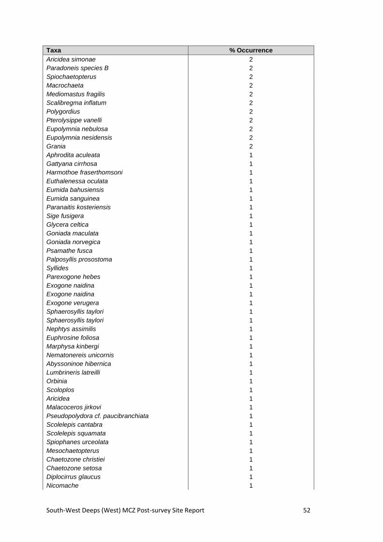
South-West Deeps (West) MCZ Post-survey Site Report 52
Taxa % Occurrence
Aricidea simonae 2
Paradoneis species B 2
Spiochaetopterus 2
Macrochaeta 2
Mediomastus fragilis 2
Scalibregma inflatum 2
Polygordius 2
Pterolysippe vanelli 2
Eupolymnia nebulosa 2
Eupolymnia nesidensis 2
Grania 2
Aphrodita aculeata 1
Gattyana cirrhosa 1
Harmothoe fraserthomsoni 1
Euthalenessa oculata 1
Eumida bahusiensis 1
Eumida sanguinea 1
Paranaitis kosteriensis 1
Sige fusigera 1
Glycera celtica 1
Goniada maculata 1
Goniada norvegica 1
Psamathe fusca 1
Palposyllis prosostoma 1
Syllides 1
Parexogone hebes 1
Exogone naidina 1
Exogone naidina 1
Exogone verugera 1
Sphaerosyllis taylori 1
Sphaerosyllis taylori 1
Nephtys assimilis 1
Euphrosine foliosa 1
Marphysa kinbergi 1
Nematonereis unicornis 1
Abyssoninoe hibernica 1
Lumbrineris latreilli 1
Orbinia 1
Scoloplos 1
Aricidea 1
Malacoceros jirkovi 1
Pseudopolydora cf. paucibranchiata 1
Scolelepis cantabra 1
Scolelepis squamata 1
Spiophanes urceolata 1
Mesochaetopterus 1
Chaetozone christiei 1
Chaetozone setosa 1
Diplocirrus glaucus 1
Nicomache 1
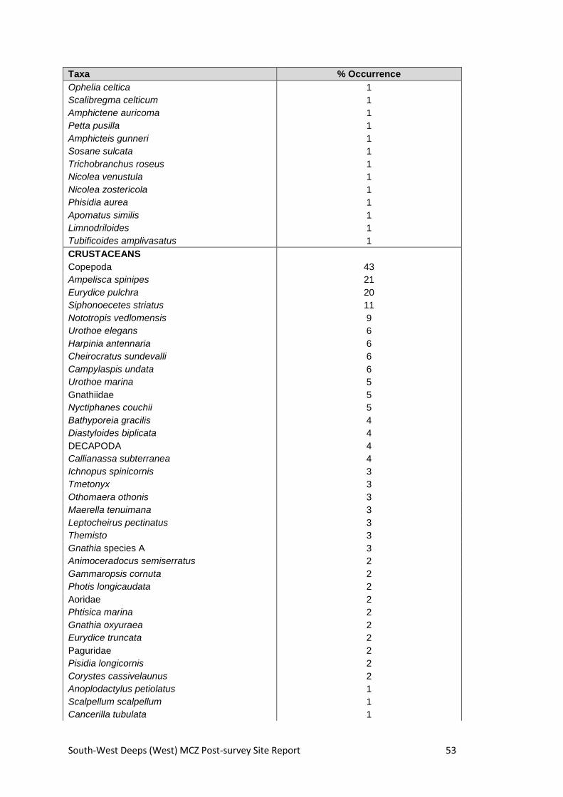
South-West Deeps (West) MCZ Post-survey Site Report 53
Taxa % Occurrence
Ophelia celtica 1
Scalibregma celticum 1
Amphictene auricoma 1
Petta pusilla 1
Amphicteis gunneri 1
Sosane sulcata 1
Trichobranchus roseus 1
Nicolea venustula 1
Nicolea zostericola 1
Phisidia aurea 1
Apomatus similis 1
Limnodriloides 1
Tubificoides amplivasatus 1
CRUSTACEANS
Copepoda 43
Ampelisca spinipes 21
Eurydice pulchra 20
Siphonoecetes striatus 11
Nototropis vedlomensis 9
Urothoe elegans 6
Harpinia antennaria 6
Cheirocratus sundevalli 6
Campylaspis undata 6
Urothoe marina 5
Gnathiidae 5
Nyctiphanes couchii 5
Bathyporeia gracilis 4
Diastyloides biplicata 4
DECAPODA 4
Callianassa subterranea 4
Ichnopus spinicornis 3
Tmetonyx 3
Othomaera othonis 3
Maerella tenuimana 3
Leptocheirus pectinatus 3
Themisto 3
Gnathia species A 3
Animoceradocus semiserratus 2
Gammaropsis cornuta 2
Photis longicaudata 2
Aoridae 2
Phtisica marina 2
Gnathia oxyuraea 2
Eurydice truncata 2
Paguridae 2
Pisidia longicornis 2
Corystes cassivelaunus 2
Anoplodactylus petiolatus 1
Scalpellum scalpellum 1
Cancerilla tubulata 1

South-West Deeps (West) MCZ Post-survey Site Report 54
Taxa % Occurrence
Sarsinebalia urgorrii 1
Lophogaster typicus 1
Haplostylus normani 1
Pontocrates species A 1
Pontocrates species B 1
Synchelidium maculatum 1
Westwoodilla caecula 1
Stenothoe marina 1
Harpinia pectinata 1
Orchomenella nana 1
Tryphosites longipes 1
Ampelisca diadema 1
Ampelisca spooneri 1
Melphidippella macra 1
Cheirocratus 1
Cheirocratus intermedius 1
Gammaropsis maculata 1
Gammaropsis palmata 1
Leptocheirus hirsutimanus 1
Unciola planipes 1
Natatolana borealis 1
Conilera cylindracea 1
Iphinoe serrata 1
Processa canaliculata 1
Galathea 1
Munida rugosa 1
Ebalia 1
Ebalia tuberosa 1
Ebalia tumefacta 1
Maja brachydactyla 1
Macropodia linaresi 1
Eurynome 1
Atelecyclus rotundatus 1
Liocarcinus 1
Liocarcinus pusillus 1
MOLLUSC
Abra prismatica 18
Thracia 12
Cochlodesma praetenue 10
Aporrhais pespelecani 7
Aeolidiidae 6
Limatula subauriculata 5
Parvicardium minimum 5
Falcidens crossotus 4
Nucula nucleus 4
Thyasira flexuosa 4
Kurtiella bidentata 4
Turritella communis 3
Euspira montagui 3
Acteon tornatilis 3

South-West Deeps (West) MCZ Post-survey Site Report 55
Taxa % Occurrence
Montacuta substriata 3
Timoclea ovata 3
Euspira nitida 2
Euspira pallida 2
Antalis vulgaris 2
Limaria loscombi 2
Similipecten similis 2
Anomiidae 2
Tellimya ferruginosa 2
Venus casina 2
Hiatella arctica 2
Atrina fragilis 1
Chaetoderma nitidulum 1
Neomenia carinata 1
Leptochiton asellus 1
Clelandella miliaris 1
Turritella communis 1
Aporrhais serresianus 1
Epitonium trevelyanum 1
Epitonium clathratulum 1
Eulima bilineata 1
Colus gracilis 1
Comarmondia gracilis 1
Cylichna cylindracea 1
Philine 1
Okenia 1
Onchidoris 1
Acanthodoris pilosa 1
Limacia clavigera 1
Ennucula tenuis 1
Modiolus 1
Pectinidae 1
Palliolum incomparabile 1
Pseudamussium peslutrae 1
Myrtea spinifera 1
Lucinoma borealis 1
Lucinoma borealis 1
Hemilepton nitidum 1
Montacuta phascolionis 1
Acanthocardia echinata 1
Laevicardium crassum 1
Spisula elliptica 1
Phaxas pellucidus 1
Arcopella balaustina 1
Angulus pygmaeus 1
Gari costulata 1
Gari fervensis 1
Gari tellinella 1
Dosinia 1
Dosinia lupinus 1

South-West Deeps (West) MCZ Post-survey Site Report 56
Taxa % Occurrence
Corbula gibba 1
Thracia phaseolina 1
Thracia villosiuscula 1
Lyonsia norwegica 1
Cuspidaria 1
Cuspidaria costellata 1
BRYOZOANS
Alderina imbellis 16
Escharella ventricosa 6
Hippothoa flagellum 5
Tubulipora 4
Entalophoroecia deflexa 4
Schizomavella auriculata 4
Pyripora catenularia 3
Disporella hispida 2
Nolella 1
Flustra foliacea 1
Amphiblestrum flemingii 1
Beania mirabilis 1
Setosella vulnerata 1
Cellaria 1
Hippothoa divaricata 1
Chorizopora brongniartii 1
Escharella immersa 1
Escharina hyndmanni 1
Schizomavella linearis 1
Microporella ciliata 1
Fenestrulina malusii 1
Cellepora pumicosa 1
Rhynchozoon bispinosum 1
HORSESHOE WORMS
Phoronis 38
Phoronis hippocrepia 2
SEA STARS, URCHINS, SEA CUCUMBERS
Ophiuridae 81
Spatangoida 80
Echinocyamus pusillus 29
Amphipholis squamata 8
Amphiuridae 6
Echinocardium cordatum 5
Amphiura filiformis 3
Spatangus purpureus 3
Leptosynapta inhaerens 3
Anseropoda placenta 2
Echinoida 2
Antedon bifida 1
Ophiocten affinis 1
Ophiura albida 1
Psammechinus miliaris 1
Cucumariidae 1

South-West Deeps (West) MCZ Post-survey Site Report 57
Taxa % Occurrence
Labidoplax digitata 1
ACORN WORMS
Enteropneusta 2
SEA SQUIRTS
Ascidiacea 10
Polycarpa fibrosa 2
Eugyra arenosa 1
FISH
Actinopterygii 2
Ammodytidae 2

South-West Deeps (West) MCZ Post-survey Site Report 58
Species list for video samples (Species FOCI indicated by grey shading, if present). Percentage occurrence was calculated as ‘Number of video samples where the species occurs/total number of video samples’ x 100.
Taxa % Occurrence
SPONGES
Suberites carnosus 22
Porifera 14
HYDROIDS, CORALS, JELLYFISH, ANEMONES
Actinauge richardi 62
Actiniaria 57
Anthozoa 28
Arachnanthus sarsi 19
Hydrozoa 19
Mesacmaea mitchellii 19
Caryophyllia 16
Halcampoides abyssorum 15
Scleractinia 15
Alcyonium 14
Hormathiidae 14
Pachycerianthus multiplicatus 14
Cerianthidae 13
Parazoanthus 13
SEGMENTED WORMS
Lanice 90
Polychaeta 35
Chaetopterus 20
Sabella 20
Ditrupa 14
Protula 14
Serpulidae 14
Terebellidae 14
CRUSTACEANS
Pagurus 74
Caridea 25
Liocarcinus depurator 19
Decapoda 18
MOLLUSCS
Buccinidae 16
Cephalopoda 15
Nudibranchia 14
Atrina fragilis 3
BRYOZOA
Cellaria 13
Vesicularia spinosa 13
SEA STARS, URCHINS, SEA CUCUMBERS
Ophiuridae 39
Asteroidea 35
Astropecten irregularis 30
Spatangus purpureus 30
Henricia 29

South-West Deeps (West) MCZ Post-survey Site Report 59
Taxa % Occurrence
Gracilechinus acutus 27
Echinoidea 26
Ophiura ophiura 24
Ophiura 22
Luidia sarsii 20
Spatangus 15
Anseropoda placenta 14
Echinus esculentus 14
Ophiura albida 14
FISH
Gadidae 15
Lepidorhombus whiffiagonis 15
Leucoraja naevus 15
Lophius 15
Pisces 19
Pleuronectiformes 34
Scyliorhinus 19
Triglidae 15

South-West Deeps (West) MCZ Post-survey Site Report 60
Appendix 5. BSH/EUNIS Level 3 descriptions derived from video and stills
*All Camera sledge positions derived from HiPAP.
Station Code Latitude Longitude Sediment Description EUNIS Level 3/BSH MNCR Code
SWDW-GT37 49.4608 -9.0426 Mixed sandy sediment with mud, and some shell fragments and granules A5.4 Subtidal mixed sediments SS.SMx.OMx
SWDW-S022 49.4440 -8.9692 Rippled mixed sandy sediment with mud, and some shell fragments and granules A5.2 Subtidal sand SS.SSa.OSa
SWDW-S012 49.4009 -9.0389 Rippled mixed sandy sediment with mud, and some shell fragments and granules A5.2 Subtidal sand SS.SSa.OSa
SWDW-GT40 49.3968 -8.9458 Muddy sand with very little shell fragment and granule content. Burrows in mud present. A5.2 Subtidal sand SS.SSa.OSa
SWDW-S027 49.3804 -8.8726 Muddy sand with very little shell fragment and granule content. Burrows in mud present. A5.2 Subtidal sand SS.SSa.OSa
SWDW-C02 49.3612 -8.9754 Muddy sand with very little shell fragment and granule content. Burrows in mud present. A5.2 Subtidal sand SS.SSa.OSa
SWDW-S104 49.3055 -9.0912 Rippled mixed sandy sediment with mud, and some shell fragments and granules A5.2 Subtidal sand SS.SSa.OSa
SWDW-S113 49.3262 -8.9912 Muddy mixed sediment with shells and some shell pragments and granules A5.4 Subtidal mixed sediments SS.SMx.OMx
SWDW-S018 49.3479 -8.8892 Muddy sand with very little shell fragment and granule content. Burrows in mud present. A5.2 Subtidal sand SS.SSa.OSa
SWDW-GT41 49.3340 -8.8487 Muddy sand with very little shell fragment and granule content. Burrows in mud present. A5.2 Subtidal sand SS.SSa.OSa
SWDW-S112 49.3049 -8.9587 Rippled mixed sandy sediment with mud, and some shell fragments and granules A5.2 Subtidal sand SS.SSa.OSa

South-West Deeps (West) MCZ Post-survey Site Report 61
Station Code Latitude Longitude Sediment Description EUNIS Level 3/BSH MNCR Code
SWDW-S103 49.2831 -9.0608 Rippled mixed sandy sediment with mud, and some shell fragments and granules A5.2 Subtidal sand SS.SSa.OSa
SWDW-S084 49.2281 -9.1815 Coarse rippled sandy sediment with some shell fragments and granules A5.2 Subtidal sand SS.SSa.OSa
SWDW-S096 49.2508 -9.0802 Rippled mixed sandy sediment with mud, and some shell fragments and granules A5.2 Subtidal sand SS.SSa.OSa
SWDW-GT39 49.2906 -8.9163 Coarse rippled sandy sediment with some shell fragments and granules A5.2 Subtidal sand SS.SSa.OSa
SWDW-S013 49.2832 -8.7902 Mixed sandy sediment with mud, turning rippled, and some shell fragments and granules A5.2 Subtidal sand SS.SSa.OSa
SWDW-S100 49.2405 -8.9945 Mixed muddy sediment with shell fragments, granules and pebbles and some empty shells A5.4 Subtidal mixed sediments SS.SMx.OMx
SWDW-S080 49.2083 -9.1514 Rippled mixed sandy sediment with mud, and some shell fragments and granules A5.2 Subtidal sand SS.SSa.OSa
SWDW-S076 49.1631 -9.2205 Mixed sandy sediment with mud, and some shell fragments and granules A5.4 Subtidal mixed sediments SS.SMx.OMx
SWDW-S089 49.1990 -9.0624 Mixed muddy sediment with shell fragments, granules and pebbles and empty shells A5.4 Subtidal mixed sediments SS.SMx.OMx
SWDW-S069 49.2285 -8.9083 Rippled mixed sandy sediment with mud, and some shell fragments and granules A5.4 Subtidal mixed sediments SS.SMx.OMx
SWDW-S015 49.2453 -8.7426 Mixed muddy sediment with shell fragments, granules and pebbles and empty shells A5.4 Subtidal mixed sediments SS.SMx.OMx
SWDW-C31 49.2150 -8.8347 Rippled mixed sandy sediment with mud, and some shell fragments and granules A5.2 Subtidal sand SS.SSa.OSa

South-West Deeps (West) MCZ Post-survey Site Report 62
Station Code Latitude Longitude Sediment Description EUNIS Level 3/BSH MNCR Code
SWDW-S093 49.1869 -8.9739 Muddy mixed sediment with pepples, shells and some shell fragments and granules A5.4 Subtidal mixed sediments SS.SMx.OMx
SWDW-S086 49.1544 -9.1321 Sparse fauna on rippled, slightly gravelly (fine shell fragments), muddy mixed sediment A5.2 Subtidal sand SS.SSa.OSa
SWDW-S046 49.1011 -9.2519 Sparse fauna on rippled, slightly muddy coarse sand with fine shell fragments A5.2 Subtidal sand SS.SSa.OSa
SWDW-S077 49.1413 -9.0466 Sparse fauna on gravelly muddy mixed sediment with shell fragments A5.4 Subtidal mixed sediments SS.SMx.OMx
SWDW-S066 49.1759 -8.8969 Sparse fauna on rippled, slightly gravelly (shell fragments), muddy mixed sediment A5.2 Subtidal sand SS.SSa.OSa
SWDW-S016 49.2097 -8.6784 Sparse fauna on gravelly, very muddy mixed sediment with empty shells A5.4 Subtidal mixed sediments SS.SMx.OMx
SWDW-S073 49.0971 -9.1166 Sparse fauna on rippled, slightly gravelly (fine shell fragments) mixed sediment A5.2 Subtidal sand SS.SSa.OSa
SWDW-S042 49.0461 -9.2394 Sparse fauna on rippled, gravelly muddy mixed sediment with shell fragments A5.1 Subtidal coarse sediment SS.SCS.OCS
SWDW-C17 49.0762 -9.1258 Sparse fauna on rippled, slightly gravelly (fine shell fragments) muddy mixed sediment A5.2 Subtidal sand SS.SSa.OSa
SWDW-C10 48.8689 -9.3513 Lanice on rippled, slightly muddy mixed sediment with shell fragments A5.2 Subtidal sand SS.SSa.OSa
SWDW-GT05 48.9734 -9.3958 Sparse fauna on rippled, slightly gravelly mixed sediment with fine shell fragments A5.2 Subtidal sand SS.SSa.OSa
SWDW-GT08 48.9973 -9.3993 Sparse fauna on rippled, slightly gravelly mixed sediment with fine shell fragments A5.2 Subtidal sand SS.SSa.OSa

South-West Deeps (West) MCZ Post-survey Site Report 63
Station Code Latitude Longitude Sediment Description EUNIS Level 3/BSH MNCR Code
SWDW-GT09 48.9473 -9.3722 Echinoderms on gravelly muddy mixed sediment with shell fragments, pebbles and empty shells A5.4 Subtidal mixed sediments SS.SMx.OMx
SWDW-GT17 48.9939 -9.3743 Sparse fauna on rippled, slightly muddy coarse sand with shell fragments A5.2 Subtidal sand SS.SSa.OSa
SWDW-S002 48.8374 -9.2569 Echinoderms and Lanice on gravelly, muddy mixed sediment with pebbles and shell fragments A5.4 Subtidal mixed sediments SS.SMx.OMx
SWDW-S002 48.8379 -9.2579 Echinoderms and Lanice on gravelly, muddy mixed sediment with pebbles and shell fragments A5.2 Subtidal sand SS.SSa.OSa
SWDW-S005 48.8945 -9.2804 Lanice and Echinoderms on slightly muddy coarse sand with shell fragments A5.2 Subtidal sand SS.SSa.OSa
SWDW-S005 48.8947 -9.2808 Lanice on gravelly muddy mixed sediment with empty shells and shell fragments A5.4 Subtidal mixed sediments SS.SMx.OMx
SWDW-S005 48.8951 -9.2814 Sparse fauna on slightly muddy coarse sand with shell fragments A5.2 Subtidal sand SS.SSa.OSa
SWDW-C05 48.9560 -9.2838 Sparse fauna on rippled coarse sand with fine shell fragments A5.2 Subtidal sand SS.SSa.OSa
SWDW-C05 48.9558 -9.28408 Sparse fauna on gravelly mixed sediment with empty shells and shell fragments A5.4 Subtidal mixed sediments SS.SMx.OMx
SWDW-GT24 48.8821 -9.1884 Actiniaria on rippled fine sand A5.2 Subtidal sand SS.SSa.OSa
SWDW-C13 48.9355 -9.2154 Lanice on gravelly muddy mixed sediment with empty shells and shell fragments A5.4 Subtidal mixed sediments SS.SMx.OMx
SWDW-C13 48.9359 -9.2155 Rippled, coarse sand with shell fragments A5.2 Subtidal sand SS.SSa.OSa

South-West Deeps (West) MCZ Post-survey Site Report 64
Station Code Latitude Longitude Sediment Description EUNIS Level 3/BSH MNCR Code
SWDW-S039 49.0131 -9.2568 Lanice on gravelly muddy mixed sediment with empty shells and shell fragments A5.4 Subtidal mixed sediments SS.SMx.OMx
SWDW-S033 48.9713 -9.1940 Lanice on rippled, slightly muddy coarse sand with shell fragments A5.2 Subtidal sand SS.SSa.OSa
SWDW-GT28 48.9087 -9.1291 Actinauge and Echinoderms on rippled, slightly muddy coarse sand with fine shell fragments A5.2 Subtidal sand SS.SSa.OSa
SWDW-GT34 48.9484 -9.0884 Sparse fauna on rippled, slightly muddy coarse sand with pebbles gathered in troughs A5.1 Subtidal coarse sediment SS.SCS.OCS
SWDW-S047 48.9690 -9.0552 Sparse fauna on gravelly, muddy mixed sediment with pebbles, shell fragments and empty shells A5.4 Subtidal mixed sediments SS.SMx.OMx
SWDW-S047 48.9691 -9.0553 Sparse fauna on coarse sand with fine shell fragments A5.2 Subtidal sand SS.SSa.OSa
SWDW-S047 48.9696 -9.0554 Sparse fauna on gravelly, muddy mixed sediment with pebbles, shell fragments and empty shells A5.1 Subtidal coarse sediment SS.SCS.OCS
SWDW-S037 49.0140 -9.1246 Sparse fauna on rippled coarse sand with fine shell fragments A5.1 Subtidal coarse sediment SS.SCS.OCS
SWDW-S037 49.0141 -9.1248 Lanice on gravelly muddy mixed sediment with shell fragments A5.4 Subtidal mixed sediment SS.SMx.OMx
SWDW-C18 49.0542 -9.1264 Slightly muddy, gravelly coarse sand, with shell fragments and sparse epifauna A5.2 Subtidal sand SS.SSa.OSa
SWDW-S050 49.0022 -9.0386 Slightly muddy, gravelly coarse sand, with some pebbles, shell fragments and sparse epifauna A5.2 Subtidal sand SS.SSa.OSa
SWDW-C22 49.0549 -9.0595 Rippled coarse sand with shell fragments and sparse epifauna A5.2 Subtidal sand SS.SSa.OSa

South-West Deeps (West) MCZ Post-survey Site Report 65
Station Code Latitude Longitude Sediment Description EUNIS Level 3/BSH MNCR Code
SWDW-C27 49.0340 -8.9940 Muddy sand with pebbles, gravel and shell fragments and sparse epifauna A5.4 Subtidal mixed sediments SS.SMx.OMx
SWDW-S058 49.1010 -8.9862 Muddy sand with pebbles, gravel and shell fragments and sparse epifauna A5.4 Subtidal mixed sediments SS.SMx.OMx
SWDW-C30 49.0401 -8.9385 Coarse sand with mud, pebbles, gravel and shell, with sparse epifauna A5.4 Subtidal mixed sediments SS.SMx.OMx
SWDW-S053 49.0922 -8.9041 Rippled sand with mud, gravel and shell fragments, with sparse epifauna A5.2 Subtidal sand SS.SSa.OSa
SWDW-S056 49.1327 -8.8355 Coarse sand with mud, gravel and shell, with sparse epifauna A5.4 Subtidal mixed sediments SS.SMx.OMx
SWDW-C36 49.1539 -8.7777 Muddy sand, with gravel, shell and pebbles, with sparse epifauna A5.4 Subtidal mixed sediments SS.SMx.OMx
SWDW-C37 49.1593 -8.7508 Sand with mud, shell fragments and some gravel, with sparse epifauna A5.2 Subtidal sand SS.SSa.OSa
SWDW AddGT01 49.2650 -8.8098 Sand with mud, gravel and shell fragments, with sparse epifauna A5.2 Subtidal sand SS.SSa.OSa
SWDW-AddGT02 49.2851 -8.8417 Sand with mud, often rippled, with gravel and shell fragments, and sparse epifauna A5.2 Subtidal sand SS.SSa.OSa
SWDW-AddGT03 49.2962 -8.8971 Rippled muddy sand, with sparse epifauna A5.2 Subtidal sand SS.SSa.OSa
SWDW-AddGT06 49.1789 -8.9304 Rippled coarse sand with shell fragments and sparse epifauna A5.2 Subtidal sand SS.SSa.OSa
SWDW-AddGT06 49.178695 -8.930940
Waves of sand with mud, with gravel and shell fragments on peaks, empty shell in troughs, sparse epifauna A5.4 Subtidal mixed sediments SS.SMx.OMx

South-West Deeps (West) MCZ Post-survey Site Report 66
Station Code Latitude Longitude Sediment Description EUNIS Level 3/BSH MNCR Code
SWDW-AddGT08 49.1961 -8.9511 Rippled sand with mud, gravel and shell fragments, with sparse epifauna A5.2 Subtidal sand SS.SSa.OSa
SWDW-AddGT05 49.2106 -8.9764 Rippled sand with some mud, gravel and shell fragments, with sparse epifauna A5.2 Subtidal sand SS.SSa.OSa
SWDW-AddGT07 49.2207 -8.9954 Rippled sand with some mud, gravel and shell fragments, with sparse epifauna A5.2 Subtidal sand SS.SSa.OSa
SWDW-AddGT07 49.221075 -8.995631
Waves of sand with mud, with gravel and shell fragments on peaks, empty shell in troughs, sparse epifauna A5.4 Subtidal mixed sediments SS.SMx.OMx
SWDW_S019 49.3684 -8.9246 Sometimes rippled sand, sometimes waves, with mud, with gravel, shell, and tubes A5.2 Subtidal sand SS.SSa.OSa
SWDW-AddGT09 49.0823 -9.0096 Gravel, shell and pebbles, on sand and mud, with sparse epifauna A5.1 Subtidal coarse sediment SS.SCS.OCS
SWDW-AddGT10 49.0718 -9.0416 Gravel, shell and pebbles, on sand and mud, with sparse epifauna A5.4 Subtidal mixed sediments SS.SMx.OMx
SWDW-S055 49.0980 -8.8600
Ripple sand with some mud, pebbles, gravel and shell fragments, with sparse epifauna. Some muddier, mixed patches early on, with no ripples. A5.1 Subtidal coarse sediment SS.SCS.OCS
SWDW-S055 49.0973 -8.8591
Ripple sand with some mud, pebbles, gravel and shell fragments, with sparse epifauna. Some muddier, mixed patches early on, with no ripples. A5.2 Subtidal sand SS.SSa.OSa
SWDW-S052 49.0579 -8.9178 Pebbles, gravel and shell, on sand and mud, with sparse epifauna A5.1 Subtidal coarse sediment SS.SCS.OCS
SWDW-GT15 48.9640 -9.3638 Pebbles, gravel and shell, on sand and mud, with sparse epifauna A5.1 Subtidal coarse sediment SS.SCS.OCS
SWDW-GT15 48.9640 -9.3640 Rippled sand with a little mud, gravel and shell, with sparse epifauna A5.2 Subtidal sand SS.SSa.OSa

South-West Deeps (West) MCZ Post-survey Site Report 67
Station Code Latitude Longitude Sediment Description EUNIS Level 3/BSH MNCR Code
SWDW-GT15 48.964035 -9.364745 Pebbles, gravel and shell, on sand and mud, with sparse epifauna A5.1 Subtidal coarse sediment SS.SCS.OCS
SWDW-GT13 48.9697 -9.3744 Rippled sand with very little mud, gravel and shell, with sparse epifauna A5.2 Subtidal sand SS.SSa.OSa
SWDW-GT20 48.9891 -9.3544 Rippled sand with very little mud, gravel and shell, with sparse epifauna A5.2 Subtidal sand SS.SSa.OSa
SWDW-GT20 48.9892 -9.3544 Pebbles, gravel and shell, on sand and mud, with sparse epifauna A5.1 Subtidal coarse sediment SS.SCS.OCS
SWDW-GT20 48.9896 -9.3543 Rippled sand with very little mud, gravel and shell, with sparse epifauna A5.2 Subtidal sand SS.SSa.OSa
SWDW-GT20 48.9897 -9.3542 Pebbles, gravel and shell, on sand and mud, with sparse epifauna A5.1 Subtidal coarse sediment SS.SCS.OCS

South-West Deeps (West) MCZ Post-survey Site Report 68
Appendix 6. Example images from survey for broadscale habitats
Broadscale Habitats Description Example Image taken during survey
A5.1: Subtidal coarse Sediment
Undersea beds of coarse sand, gravel and shingle
A5.2: Subtidal sand Undersea beds of sand
A5.3: Subtidal mud Undersea beds of mud
A5.4: Subtidal mixed sediments
Undersea beds of a mixture of stones, gravels, sands and muds

South-West Deeps (West) MCZ Post-survey Site Report 69
Appendix 7. Example images from survey for habitat FOCI
Habitat FOCI Description Example Image taken during survey
Subtidal Sands and Gravels
Sand and gravel seabeds widespread around the UK
Mud Habitats in Deep Water
Mud sediments in low energy, stable environments
Species FOCI Example Image taken during survey
Atrina fragilis

South-West Deeps (West) MCZ Post-survey Site Report 70
This page intentionally left blank

© Crown Copyright 2015