South Wales Gas Pipeline Project Land West of …...1.2 In June and July 2007CA P carried out an...
32
South Wales Gas Pipeline Project Site 20.08 Land West of Pengoilan Llanfihangel Aberbythych Carmarthenshire Archaeological Excavation December 2013 for on behalf of Rhead Group National Grid CA Project: 9150 CA Report: 13287 Event: DAT108792
Transcript of South Wales Gas Pipeline Project Land West of …...1.2 In June and July 2007CA P carried out an...

South Wales Gas Pipeline Project Site 20.08
Land West of Pengoilan Llanfihangel Aberbythych
Carmarthenshire
Archaeological Excavation
December 2013
for
on behalf of Rhead Group
National Grid CA Project: 9150
CA Report: 13287 Event: DAT108792
South Wales Gas Pipeline Project Site 20.08
Archaeological Excavation
CA Project: 9150 CA Report: 13287 Event: DAT102846
prepared by Christopher Leonard, Project Supervisor
date 12 December 2013
checked by Karen E Walker, Post-Excavation Manager
date 9th July 2015
approved by Martin Watts, Project Director, Head of Publications
signed
date
issue 01
This report is confidential to the client. Cotswold Archaeology accepts no responsibility or liability to any third party to whom this report, or any part of it, is made known. Any such party relies upon this report entirely
at their own risk. No part of this report may be reproduced by any means without permission.
© Cotswold Archaeology
Cirencester Milton Keynes Andover Building 11 Unit 4 Office 49 Kemble Enterprise Park Cromwell Business Centre Basepoint Business Centre Kemble, Cirencester Howard Way, Newport Pagnell Caxton Close, Andover Gloucestershire, GL7 6BQ MK16 9QS Hampshire, SP10 3FG t. 01285 771022 t. 01908 218320 t. 01264 326549 f. 01285 771033
© Cotswold Archaeology
1
South Wales Gas Pipeline Project Site 20.08: Archaeological Excavation
CONTENTS
SUMMARY ..................................................................................................................... 2
1. INTRODUCTION ................................................................................................ 3
2. RESULTS (FIGS 2–4) ........................................................................................ 5
3. PROJECT TEAM ............................................................................................... 9
4. REFERENCES ................................................................................................... 10
APPENDIX A: CONTEXT DESCRIPTIONS .................................................................... 13
APPENDIX B: THE FINDS .............................................................................................. 16
APPENDIX C: THE PALAEOENVIRONMENTAL EVIDENCE BY JAMES RACKHAM .... 18
LIST OF ILLUSTRATIONS Fig. 1 Site location plan (1:25,000)
Fig. 2 Plan of archaeological features (1:500)
Fig. 3 Plan of the northern area of site (1:250)
Fig. 4 Plan of the southern area of site and north-facing section of ditch 208107 (1:200 and
1:20)
Fig. 5 Photograph: general view of southern part of Site 20.08 within its landscape setting, looking east
GLOSSARY CA – Cotswold Archaeology
CAP – Cambrian Archaeological Projects
CPAT – Clwyd Powys Archaeological Trust
DAT – Dyfed Archaeological Trust
GGAT - Glamorgan Gwent Archaeological Trust
FTP – Felindre to Brecon gas pipeline
HER – Historic Environment Record
MHA – Milford Haven to Aberdulais gas pipeline
NAL – Network Archaeology Ltd
NLMJV – Nacap Land & Marine Joint Venture
UPD – Updated Project Design
© Cotswold Archaeology
2
South Wales Gas Pipeline Project Site 20.08: Archaeological Excavation
SUMMARY
Project Name: South Wales Gas Pipeline Project
Location: Land West of Pengoilan, Llanfihangel Aberbythych,
Carmarthenshire
NGR: SN 6019 2108
Type: Excavation
Date: 26 June–16 July 2007
Location of Archive: To be deposited with RCAHMW (original paper archive) and
Carmarthenshire Museum (material archive and digital copy of
paper archive; accession number CAASG 2008.0282)
Site Code: MHA06
An archaeological excavation was undertaken by Cambrian Archaeological Projects (CAP)
during groundworks associated with construction of gas pipelines (part of the South Wales
high pressure gas pipeline scheme) between Milford Haven and Aberdulais, and Felindre
and Brecon, which were conducted between 2005 and 2007.
A rectangular pit containing burnt stones and a sherd of Neolithic or Bronze Age pottery was
identified. The function of this pit is not certain, although it is possible that it was a trough
associated with hot stone technology. Further early prehistoric activity on site was attested
by Mesolithic and Neolithic flints, however these were all residual in later contexts, or
unstratified.
A penannular ditch, probably the remains of a roundhouse, was found and this together with
several small pits indicates the presence of a Late Iron Age/Early Roman settlement, the full
extent of which was probably not exposed. A Roman glass counter was recovered, although
it is not known whether or not this was a residual find.
Several possibly medieval features were also present. The dates and functions of these
were unclear however, although one contained a stone comparable to medieval linen
rubbing stones found elsewhere. An undated possible enclosure was found. It was not clear
whether this enclosure related to the roundhouse settlement, the possibly medieval features,
or to another phase of activity entirely. A small number of undated features were also found.

© Cotswold Archaeology
3
South Wales Gas Pipeline Project Site 20.08: Archaeological Excavation
1. INTRODUCTION
1.1 NACAP Land and Marine Joint Venture (NLMJV), on behalf of National Grid,
commissioned RSK Environment (part of the RSK Group) to manage the
archaeological works (non-invasive surveys, desk based assessment, evaluation,
watching brief, and open area excavation) on a 216km-long section of pipeline from
Milford Haven (Pembrokeshire) to Brecon (in Powys). The high pressure gas
pipeline (part of the 316km-long pipeline route from Milford Haven to Tirley in
Gloucestershire) was required to reinforce the gas transmission network. The
archaeological work performed in advance of this pipeline was undertaken in a
number of sections by a number of archaeological companies. The westernmost
section of 122km, from Milford Haven to Aberdulais, was investigated by CA (then
Cotswold Archaeological Trust) during 2005–2007 with some additional excavation
work carried out by CAP. The section of 89km, from Felindre to Brecon was
investigated by CA during 2006–2007 and CAP during 2007. Assessment reports on
the works were completed in January 2012 (NLM 2012a, 2012b) and the current
reporting stage was commissioned in February 2013.
1.2 In June and July 2007 CAP carried out an archaeological excavation at Site 20.08,
Land West of Pengoilan, Llanfihangel Aberbythych, Carmarthenshire (centred on
NGR: SN 6019 2108; Fig. 1). The objective of the excavation was to record all
archaeological remains exposed during the pipeline construction.
1.3 The excavation was carried out in accordance with professional codes, standards
and guidance documents (EH 1991; IfA 1999a, 1999b, 2001a, 2001b and IfA Wales
2008). The methodologies were laid out in an Archaeological Framework Document
(RSK 2007) and associated Written Statements of Investigation (WSIs) and Method
Statements.
The site 1.4 The site was located just below the summit of a low prominence bordering the River
Towy floodplain (Fig. 1). The Towy valley at this point is broad and flat and the site is
situated at approximately 40m AOD. The underlying solid geology of the area is
mapped as the Abergwilli Mudstone Formation of the Ordovician Period overlain by
superficial Quaternary Till (BGS 2013).

© Cotswold Archaeology
4
South Wales Gas Pipeline Project Site 20.08: Archaeological Excavation
Archaeological background 1.5 No archaeological remains were identified within the site during the preliminary
Archaeology and Heritage Survey (CA 2006). The Roman road traversing the Towy
Valley (CA 2006, map 5) ran 1.8km south-east of the site. Another road on the
opposite side of the valley, 1.75km north of the site, is thought to be Roman in date,
although an excavation at pipeline Site 22.02 could not confirm this (CA 2013). Later
remains include the ruins of the medieval Dynefor Castle (PRN880) which lie 1.2km
north-east of the site.
Archaeological objectives 1.6 The objectives of the archaeological works were:-
• to monitor groundworks, and to identify, investigate and record all significant buried
archaeological deposits revealed on the site during the course of the development
groundworks; and
• at the conclusion of the project, to produce an integrated archive for the project work
and a report setting out the results of the project and the archaeological conclusions
that can be drawn from the recorded data.
Methodology
1.7 The fieldwork followed the methodology set out within the WSI (NLM 2006). An
archaeologist was present during intrusive groundworks comprising stripping of the
pipeline easement to the natural substrate (Fig. 1).
1.8 The post-excavation work was undertaken following the production of the UPD (GA
2012) and included re-examination of the original site records. Finds and
environmental evidence was taken from the assessment reports (NLM 2012b)
except where the UPD recommended further work, in which case the updated
reports were used. The archaeological background to the site was assessed using
the following resources:-
• the Archaeology and Heritage Survey which was undertaken in advance of the
pipeline construction and which examined a 1km-wide corridor centred on the
pipeline centre line, including the then existing HER record (CA 2006);
• Dyfed Archaeological Trust HER data (received July 2014); and
• other online resources, such as Google Earth and Ordnance Survey maps
available at http://www.old-maps.co.uk/index.html.

© Cotswold Archaeology
5
South Wales Gas Pipeline Project Site 20.08: Archaeological Excavation
All monuments thus identified that were relevant to the site were taken into account
when considering the results of the fieldwork.
1.9 The archive and artefacts from the watching brief are currently held by CA at their
offices in Kemble. Subject to the agreement of the legal landowner the artefacts will
be deposited with Carmarthenshire Museum under accession number CAASG
2008.0282, along with a digital copy of the paper archive. The original paper archive
will be deposited with the RCAHMW.
2. RESULTS (FIGS 2–5)
2.1 This section provides an overview of the excavation results; detailed summaries of
the recorded contexts, finds and environmental samples (palaeoenvironmental
evidence) are to be found in Appendices A, B and C. Full, original versions of the
specialist reports are contained within the archive. The natural geological substrate
(208105), comprising orange-red clay silt, was cut by ditches, pits and postholes.
These features were found to the north and south of an existing field boundary.
Neolithic/Bronze Age
2.2 Elongated pit 208167 was located in the southern part of the site within the area
bounded by an undated enclosure ditch (Fig. 4). The pit was 2.4m long, 0.45m wide
and 0.25m deep and contained charcoal-rich lower fill 208175 overlain by dark grey
sandy clay 208156 which included large quantities of burnt stone, charcoal, and
hazelnut shell fragments along with a single small sherd of Neolithic or Bronze Age
pottery.
Late Iron Age/Early Roman
2.3 A small group of Late Iron Age/Early Roman features was found to the north of the
existing field boundary (Fig. 3). These included a penannular ditch and three pits.
Penannular ditch 208111 consisted of a V-profiled cut 0.15m wide and 0.2m deep
and enclosed an area 14.5m in diameter. It included a 14m-wide north-facing
entrance apparently defined by postholes 208133 and 208160, but it is possible that
at least part of this gap was due to truncation given the shallow depth of the
surviving ditch. A possible re-cut (208119) was present along the southern part of

© Cotswold Archaeology
6
South Wales Gas Pipeline Project Site 20.08: Archaeological Excavation
the ditch circuit and the ditch was filled by grey silty clay 208118. This ditch was
most probably part of a roundhouse.
2.4 The three pits were all found within the area enclosed by the penannular ditch. Pit
208114 was sub-rectangular in plan, 1.6m long, 0.4m wide and 0.18m deep with
steep sides and a flat base. It contained a single dark brown sandy fill (208115)
which included frequent burnt stones and five sherds of Late Iron Age/Early Roman
pottery. Samples from this fill contained large quantities of charcoal and charred
hazelnut shells. Pit 208120 was sub-rectangular in plan, 0.65m long and 0.15m
deep with steep sides and a flat base. It was filled with silty clay deposits which
contained small amounts of charcoal and had been truncated on its east side by pit
208124, which was oval in plan, 0.9m long, 0.6m wide and 0.2m deep. This pit
contained unidentifiable burnt animal bone. Although pits 208120 and 208124 were
undated by finds, their location in plan may indicate that they were associated with
the penannular ditch.
Medieval
2.5 A small group of features which may have been medieval in date was present to the
south of the existing field boundary (Fig. 4). Pit 208174 was cut into the upper fill of
undated enclosure ditch 208107 (see below). It was circular in plan, 0.6m wide and
0.2m deep with vertical sides and a flat base. Its lower fill, 208173, was a thin,
charcoal-rich deposit containing hazelnut shell fragments and a bread wheat-type
cereal grain. Bread wheat was widely used from the early medieval period onwards
and later prehistoric use is also known. However, whilst the presence of a single
grain does not provide storing dating evidence, when taken with the pit’s proximity to
more probably medieval features (see below), medieval dating is perhaps more
likely than late prehistoric.
2.6 To the east, a small curvilinear ditch (208182) terminating at two pits was found.
Ditch 208182 was 6.75m long, 0.2m wide and 0.15m deep with steep sides and a
flat base. Its fill (208110) was charcoal-rich and contained a pebble with a polished
surface, comparable in form to early medieval or later linen smoothers, but which
could not be securely dated. The ditch also contained flints, including microdebitage
and shatter. The northern end of the ditch terminated at pit 208157. This small pit
was circular in plan with a bowl-shaped profile. It was filled with charcoal-rich red
clay 208109, and samples from this yielded hazelnut shell fragments and cereal
grains, including one that was poorly preserved and was possibly either a hulled
© Cotswold Archaeology
7
South Wales Gas Pipeline Project Site 20.08: Archaeological Excavation
wheat or rye. The latter would confer a medieval date, however as the grain was not
conclusively identifiable to species, this could not be ascertained with any
confidence (Appendix C). The fill also contained a single, possibly residual flint chip.
A second pit/posthole (un-numbered) was present at the southern end of the ditch.
Post-medieval/Modern
2.7 Parallel ditches 208100 and 208102 were located to the south of the modern hedge
and were north-west/south-east aligned, 0.7m apart (Fig. 4). They comprised cuts
with moderately steep sides and concave bases and were up to 1m wide and 0.2m
deep. Both had filled naturally and contained no finds. These were hedge-bank
ditches forming a field boundary that was depicted on the 1st Edition OS map of
Carmarthenshire (1884–1886) and was present up to the 1987 Edition.
Undated
2.8 Curvilinear ditches 208107 and 208108 were found within the southern part of the
site (Fig. 5). The easternmost ditch (208108) continued beyond the excavation but
the westernmost ditch (208107) seemed to terminate beneath post-
medieval/modern ditch 208100, although this stratigraphic relationship was not
tested by excavation and there was no depiction of a ditch adjoining the hedge-bank
on historic mapping. Although only partially exposed within the site, these features
perhaps defined an enclosure with a 2.5m-wide north-east facing entrance. The
ditches were up to 1.2m wide and 1m deep with steep, V-shaped profiles (Fig. 4,
section AA). They had filled naturally and monolith samples through their fills
indicated that the lowest fills had been subject to seasonal waterlogging and may
have formed quite rapidly, but that the upper fills had accumulated slowly enough for
a layer of turf to form (Appendix C). Samples from the upper fills yielded poorly
preserved cereal grains, including hulled barley. The upper fills also contained four
struck flints, including an Early Neolithic scraper, two Mesolithic or Early Neolithic
flakes and one piece that was not closely dateable, but it is not known whether this
material was contemporary with the ditch or was residual.
2.9 Just inside the enclosure entrance was pit 208183. This was oval in plan with gently
sloping sides and a concave base and was almost entirely filled by a large oval-
shaped stone (208176). This stone was scorched and was not recovered for
examination, although it was noted in the field that it may have been a quern or
grinding stone. A few postholes were located near the edges of the enclosure ditch;
all were undated and there was no recognisable pattern to their distribution.

© Cotswold Archaeology
8
South Wales Gas Pipeline Project Site 20.08: Archaeological Excavation
2.10 A further undated feature, ditch 208153, was found to the north of the existing field
boundary and immediately north-west of penannular ditch 208111 (Fig. 3). It was
aligned north-east/south-west and was 6m wide and 0.4m deep with gently sloping
sides and a concave base, although it was somewhat irregular in plan. Its primary
silt 208154 was overlain by a deposit of burnt stones within a dark grey silty clay
matrix, 208136. This fill included a Neolithic flake and a Roman glass counter. The
flake was probably residual but it is unclear whether the counter dates the ditch or
was also residual. This fill was in turn covered by 208155, a thin layer of silty clay.
Given the uncertainty over the provenance of the Roman glass counter, this ditch is
best regarded as undated and its relationship to the penannular ditch was not
established. Rackham in Appendix C suggests that this ‘ditch’ could in fact have
been an erosion channel resulting from seasonal run-off and also suggests that this
could have formed during the medieval period.
Discussion Early prehistoric
2.11 The dating of features on site is problematic due to the small finds assemblage
recovered. Much of the flint assemblage may have been residual, but does indicate
a background of early prehistoric activity, as does the Neolithic or Bronze Age
pottery sherd recovered from pit 208167. The size, shape and fill of pit 208167 are
characteristic of troughs associated with burnt mounds elsewhere along the pipeline.
There was no evidence of a mound within the site but it is possible that any former
mound had been entirely denuded, or that heating activities in this instance were not
of sufficient intensity to have produced a mound of debris.
Late Iron Age/Early Roman
2.12 The penannular ditch and the pits enclosed by it reveal that the site was occupied
during the Late Iron Age/Early Roman period and Malvernian Ware found 2km
north-east of the site at Llandeilo Roman fort (Ken Murphy pers. comm. to Jonathan
Hart) may suggest that these features were Roman rather than Iron Age. The
presence of postholes within the roundhouse ditch suggests that it had formed the
foundation trench for the roundhouse wall, rather than having been an external drip
gully. It is possible that the undated D-shaped enclosure was part of this occupation
since it contained debris characteristic of occupation sites (See Appendix C),
although this must remain as speculation on the basis of the current evidence. Given
the narrow confines of the pipeline corridor, further parts of this settlement may
await discovery.

© Cotswold Archaeology
9
South Wales Gas Pipeline Project Site 20.08: Archaeological Excavation
Medieval
2.13 The small group of features tentatively assigned to the medieval period are in fact
poorly dated and are difficult to interpret. It is possible that they related to some sort
of production process, but, aside from the possible linen smoother, the nature of any
such process is unclear. Although assigned a medieval date, largely on the typology
of the polisher, these features might instead have been associated with the Late Iron
Age/Early Roman settlement.
3. PROJECT TEAM
Fieldwork was undertaken by CAP. This report was written by Christopher Leonard
with comments by Jonathan Hart and illustrations prepared by Daniel Bashford. The
archive has been compiled by Jonathan Hart and prepared for deposition by Hazel
O’Neill. The fieldwork was managed for CAP by Kevin Blockley and the post-
excavation was managed for CA by Karen Walker.
© Cotswold Archaeology
10
South Wales Gas Pipeline Project Site 20.08: Archaeological Excavation
4. REFERENCES
Ashmore, P. 1999 ‘Radiocarbon dating: avoiding errors by avoiding mixed samples’, in
Antiquity 73, 124–30
BGS (British Geological Survey) 2013 Geology of Britain Viewer. Online resource at
http://mapapps.bgs.ac.uk/geologyofbritain/home.html accessed 18 November 2013
Bronk Ramsey, C. 1995 ‘Radiocarbon calibration and analysis of stratigraphy: the OxCal
program’, Radiocarbon 37(2), 425–30
Bronk Ramsey, C. 1998 ‘Probability and dating’, in Radiocarbon 40(1), 461–74
Bronk Ramsey, C. 2001 ‘Development of the radiocarbon calibration program OxCal.’, in
Radiocarbon 43(2A), 355–63
Bronk Ramsey, C. 2009 ‘Bayesian analysis of radiocarbon dates’, in Radiocarbon 51(1), 337–60
CA (Cotswold Archaeology) 2006 Felindre to Tirley Gas Pipeline: Archaeology and Heritage
Survey. CA typescript report 05140 CA (Cotswold Archaeology) 2013 South Wales Pipeline Site 22.02 Land North of Pen-y-
banc Farm, Llangathen, Carmarthenshire: Archaeological Watching Brief. CA
typescript report 13293 Carruthers, W. 2008 ‘Assessment Report for Charred Plant Remains’ in NLM 2012b Carruthers, W. 2000 ‘The charred hazelnut shell and other plant remains’ in S. Mithen (ed.)
Hunter-gatherer landscape archaeology. The Southern Hebrides Mesolithic Project
1988-98. Vol 2: Archaeological fieldwork on Colonsay, computer modeling,
experimental archaeology, and final interpretations. McDonald Institute Monograph,
407-415.
Edlin, H.L 1949 Woodland crafts in Britain: an account of the traditional uses of trees and
timbers in the British countryside. London, Batsford
EH (English Heritage) 1991 The Management of Archaeological Projects 2
EH (English Heritage) 2011 Burnt Mounds English Heritage Introductions to Heritage Assets
Freeman, S., G. Cook, A. Dougans, P. Naysmith, K. Wicken and S. Xu 2010 ‘Improved
SSAMS performance’, in Nuclear Instruments and Methods Physics Research B
268, 715–17
GA (Groundwork Archaeology) 2012 Milford Haven to Aberdulais and Felindre to Brecon
High Pressure Gas Pipelines: Updated Project Design
Gibson, A. 2013 Milford Haven to Aberdulais and Felindre to Brecon Gas Pipeline: The
Neolithic and Bronze Age Pottery from the Archaeological Investigations. Gibson
typescript report no. 121
© Cotswold Archaeology
11
South Wales Gas Pipeline Project Site 20.08: Archaeological Excavation
IfA (Institute for Archaeologists) 1999a Guidelines for Finds Work. IfA, Birmingham
IfA (Institute for Archaeologists) 1999b Standard and Guidance for Finds and Ecofact
Studies and Curation. IfA, Reading
IfA (Institute for Archaeologists) 2001a Standard and Guidance for the Collection,
Documentation, Conservation and Research of Archaeological Materials. IfA,
Reading
IfA (Institute for Archaeologists) 2001b Standard and Guidance for Archaeological
Excavation
IfA Wales (Institute for Archaeologists of Wales/Cymru) 2008 Introducing a Research
Framework for the Archaeology of Wales, online resource at
http://www.archaeoleg.org.uk/intro.html accessed December 2008
Manning, W.H. 1995 Report on the Excavations at Usk 1965–1976: The Roman Small
Finds.Cardiff, University of Wales Press
Mook, W. G. and H. T. Waterbolk 1985 Handbook for archaeologists. No 3. Radiocarbon
dating. Strasbourg; European Science Foundation
NLM (Nacap Land and Marine) 2006 Milford Haven to Aberdulais Natural Gas Pipeline:
Scheme of investigation for a programme of archaeological works
NLM (Nacap Land and Marine) 2012a Milford Haven to Aberdulais High Pressure Gas
Pipeline: Archaeology Assessment of Potential for Analysis
NLM (Nacap Land and Marine) 2012b Felindre to Brecon High Pressure Gas Pipeline:
Archaeology Assessment of Potential for Analysis
Old Maps 2013 Online resource at http://www.old-maps.co.uk/maps.html accessed 18
November 2013
Pannett, A. 2014 Milford Haven to Brecon LNG Pipeline: Lithic Analysis Report A. Pannett
typescript report
Price, J. 1995 ‘Glass Counters and Gaming Pieces’, in Manning 1995, 129–34
Reimer, P., E. Bard, A. Bayliss, J. Beck, P. Blackwell, C. Bronk Ramsey, P. Grootes, T.
Guilderson, H. Haflidason, I. Hajdas, C. Hatté, T. Heaton, D. Hoffmann, A. Hogg, K.
Hughen, K. Kaiser, B. Kromer, S. Manning, M. Niu, R. Reimer, D. Richards, E. Scott,
J. Southon, R. Staff, C. Turney and J. van der Plicht 2013 ‘IntCal13 and Marine13
Radiocarbon Age Calibration Curves 0–50,000 Years cal BP’, in Radiocarbon 55(4), 1869–87
Ripper, S. and Beamish, M. 2012 ‘Bogs, Bodies and Burnt Mounds: Soar Wetlands in the
Neolithic and Early Bronze Age’ Proceedings of the Prehistoric Society 78 173–206
RSK (RSKENSR) 2007 Felindre to Tirley Natural Gas Pipeline: Archaeological Framework
Document, v7. Nacap Land and Marine Final, RSKENSR Environmental Ltd
© Cotswold Archaeology
12
South Wales Gas Pipeline Project Site 20.08: Archaeological Excavation
Slota Jr, P.J., A.J.T. Jull, T.W. Linick and L.J. Toolin 1987 ‘Preparation of small samples for
radiocarbon accelerator targets by catalytic reduction of CO’, in Radiocarbon 29,
303–6
Stace, C. 2010 New Flora of the British Isles. Third Edition. Cambridge, CUP
Stuiver, M. and R. S. Kra 1986 ‘Editorial comment’, in Radiocarbon 28(2B), ii Stuiver, M. and H. A. Polach 1977 ‘Discussion, reporting of 14C data’, in Radiocarbon 19(3),
355–63
Stuiver, M. and P. J. Reimer 1986 ‘A computer program for radiocarbon age calculation’, in
Radiocarbon 28, 1022–30
Stuiver, M. and P. J. Reimer 1993 ‘Extended 14C data base and revised CALIB 3.0 14C age
calibration program’ in Radiocarbon 35, 215–30
Timby, J. R. 2013 South wales Pipeline Project: Roman pottery publication summary.
Unpublished typescript report for National Grid
Vandeputte, K., L. Moens and R. Dams 1996 ‘Improved sealed-tube combustion of organic
samples to CO2 for stable isotope analysis, radiocarbon dating and percent carbon
determinations’, in Analytical Letters 29, 2761–73
Vince, A. and Steane, K. 2008 ‘Assessment Report for Stone’ in NLM 2012b
Ward, G.K. and, Wilson, S.R. 1978 ‘Procedures for Comparing and Combining Radiocarbon
Age Determinations: a critique’, in Archaeometry 20, 19–31
Wood, J. 2009 ‘Assessment report for Faunal Remains’ in NLM 2012b
Xu, S., R. Anderson, C. Bryant, G. T. Cook, A. Dougans, S. Freeman, P. Naysmith, C.
Schnabel and E. M. Scott 2004 ‘Capabilities of the new SUERC 5MV AMS facility for
14C dating’ in Radiocarbon 46, 59–64
Zohary, D. & Hopf, M. 2000 Domestication of Plants in the Old World. 3rd Edition. Oxford,
OUP

© Cotswold Archaeology
13
South Wales Gas Pipeline Project Site 20.08: Archaeological Excavation
APPENDIX A: CONTEXT DESCRIPTIONS
Context Fill of Interpretation Description L (m)
W (m)
Depth (m)
Spot date
208100 Ditch NE/SW aligned. Linear in plan with moderately steep sides and concave base
1.0 1.0 0.15
208101 Ditch Part of 208100 1.0 0.85 0.1 208102 Ditch NE/SW aligned. Linear in plan
with gently sloping sides and concave base
1.0 1.0 0.2
208103 208102 Ditch fill Mid red-brown sand 1.0 1.0 0.2 208104 Subsoil Light grey-brown sandy silt.
common sub-angular stones 0.2
208105 Natural Light orange-red clay silt 208106 208100 Ditch fill Mid red-brown sand 1.0 1.0 0.15 208107 Ditch Curvilinear in plan with steep
sides and concave base
208108 Ditch Ditch terminus. Curvilinear in plan with steep sides and concave base
1.0 1.2 0.75
208109 208157 Pit fill Red clay. Occasional charcoal flecks
0.45 0.4 0.15
208110 208182 Ditch fill Mid grey-brown clay. Occasional charcoal and small stones
1.0 0.2 0.15
208111 Gully Curvilinear in plan; V-shaped with steep sides
0.15 0.15
208112 Posthole cut/fill
Circular in plan with flat base. filled by mid grey-brown silty sand
0.35 0.35 0.05
208113 208114 Pit fill =208115 0.6 0.4 0.3 208114 Pit Rectangular in plan with steep
sides and flat base 1.6 0.4 0.3 IA/
Roman 208115 208114 Pit fill Dark brown-grey sandy silt.
Common medium and large angular stones
0.7 0.4 0.3
208116 Subsoil =208104 0.3 208117 Natural =208105 208118 208111 Gully fill Light orange-grey silty clay.
Occasional smack, angular stones 0.15 0.15
208119 Gully Part of 208111 0.4 0.1 208120 Pit Oval in plan with steep sides and
flat base 0.65 >0.2 0.15
208121 208120 Pit fill Upper fill: light orange-grey silty clay. Occasional small stones
0.65 >0.2 0.10
208122 208120 Pit fill Lower fill: mid orange-grey sandy silt. Frequent charcoal flecks.
0.65 >0.2 0.05
208123 208111 Gully fill =208118 208124 Pit Oval in plan with steep sides and
flat base 0.9 0.6 0.2
208125 208124 Pit fill Upper fill: mid red-grey clay silt. Occasional small stones and charcoal flecks
0.9 0.1 0.2
208126 Context not used 208127 Context not used 208128 208108 Ditch fill Upper fill: light orange-brown clay.
Occasional stones 1.2 0.45 Meso/
EN 208129 Field drain 0.3 0.15 208130 Ditch Part of 208100 1.05 0.3 208131 Ditch fill =208106 1.05 0.3 208132 208129 Field drain 0.3 0.15
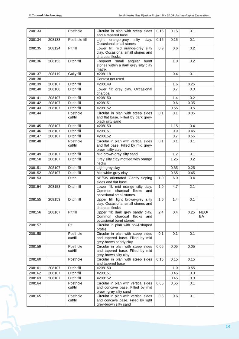
© Cotswold Archaeology
14
South Wales Gas Pipeline Project Site 20.08: Archaeological Excavation
208133 Posthole Circular in plan with steep sides and a tapered base
0.15 0.15 0.1
208134 208133 Posthole fill Light orange-grey silty clay. Occasional small stones
0.15 0.15 0.1
208135 208124 Pit fill Lower fill: mid orange-grey silty clay. Occasional small stones and charcoal flecks
0.9 0.6 0.2
208136 208153 Ditch fill Frequent small angular burnt stones within a dark grey silty clay matrix
1.0 0.2
208137 208119 Gully fill =208118 0.4 0.1 208138 Context not used 208139 208107 Ditch fill =208149 1.6 0.25 208140 208108 Ditch fill Lower fill: grey clay. Occasional
charcoal 0.7 0.3
208141 208107 Ditch fill =208150 1.4 0.2 208142 208107 Ditch fill =208151 0.6 0.35 208143 208107 Ditch fill =208152 0.55 0.5 208144 Posthole
cut/fill Circular in plan with steep sides and flat base. Filled by dark grey-black silty sand
0.1 0.1 0.35
208145 208107 Ditch fill =208150 1.15 0.4 208146 208107 Ditch fill =208151 0.9 0.45 208147 208107 Ditch fill =208152 0.7 0.55 208148 Posthole
cut/fill Circular in plan with vertical sides and flat base. Filled by mid grey-brown silty clay
0.1 0.1 0.1
208149 208107 Ditch fill Mid brown-grey silty sand 1.2 0.1 208150 208107 Ditch fill Grey silty clay mottled with orange
flecks 1.25 0.2
208151 208107 Ditch fill Light grey clay 0.85 0.25 208152 208107 Ditch fill Mid white-grey clay 0.65 0.45 208153 Ditch NE/SW orientated. Gently sloping
sides and flat base 1.0 6.0 0.4
208154 208153 Ditch fill Lower fill: mid orange silty clay. Common charcoal flecks and occasional small stones.
1.0 4.7 2.1
208155 208153 Ditch fill Upper fill: light brown-grey silty clay. Occasional small stones and charcoal flecks
1.0 1.4 0.1
208156 208167 Pit fill Upper fill: dark grey sandy clay. Common charcoal flecks and occasional burnt stones
2.4 0.4 0.25 NEO/ BA
208157 Pit Circular in plan with bowl-shaped profile
208158 Posthole cut/fill
Circular in plan with steep sides and tapered base. Filled by mid grey-brown sandy clay
0.1 0.1 0.1
208159 Posthole cut/fill
Circular in plan with steep sides and tapered base. Filled by mid grey-brown silty clay
0.05 0.05 0.05
208160 Posthole Circular in plan with steep sides and tapered base
0.15 0.15 0.15
208161 208107 Ditch fill =208150 1.0 0.55 208162 208107 Ditch fill =208151 0.45 0.3 208163 208107 Ditch fill =208152 0.45 0.3 208164 Posthole
cut/fill Circular in plan with vertical sides and concave base. Filled by mid brown-grey silty sand
0.65 0.65 0.1
208165 Posthole cut/fill
Circular in plan with vertical sides and concave base. Filled by light grey-brown silty sand
0.6 0.6 0.1

© Cotswold Archaeology
15
South Wales Gas Pipeline Project Site 20.08: Archaeological Excavation
208166 208160 Posthole fill Mid yellow-grey clay silt. Occasional small stones
0.15 0.15 0.15
208167 Pit Oval in plan with steep sides and flat base
2.4 0.45 0.25
208168 Posthole cut/fill
Circular in plan with vertical sides and concave base. Filled by mid brown-grey silty sand
0.05 0.05 0.1
208169 Posthole cut/fill
Circular in plan with steep sides and concave base. Filled by mid brown-grey silty sand
0.05 0.05 0.1
208170 208107 Ditch fill =208149 0.6 0.25 208171 Posthole
cut/fill Circular in plan with steep sides and tapered base. Filled by mid brown-grey silty sand
0.1 0.1 0.1
208172 208174 Pit fill Upper fill: mid orange-grey silty clay. Common charcoal and occasional small stones
0.6 0.6 0.15
208173 208174 Pit fill Lower fill: dark grey-black silty clay. Frequent charcoal
0.55 0.55 0.05
208174 Pit Circular in plan with vertical sides and flat base
0.6 0.6 0.2
208175 208167 Pit fill Lower fill: charcoal within a dark grey-black matrix. Occasional small stones
2.3 0.3 0.1
208176 208183 Stone Large oval-shaped stone 0.55 0.3 0.1 208177 Context not used 208178 Tree-throw pit 0.2 0.2 0.15 208179 Tree-throw pit 0.15 0.15 0.15 208180 208181 Tree-throw pit
fill Light grey clay sand. Occasional charcoal flecks
0.8 0.75 0.2
208181 Tree-throw pit Irregular in plan with steep sides and irregular base
0.8 0.75 0.2
208182 Ditch Curvilinear, steep sides, flat base 6.75 0.2 0.15 208183 Pit Oval in plan with gently sloping
sides and concave base 0.9 0.65 0.2
208184 208183 Pit fill Light yellow-brown sandy silt. Occasional small angular stones
0.9 0.65 0.2
© Cotswold Archaeology
16
South Wales Gas Pipeline Project Site 20.08: Archaeological Excavation
APPENDIX B: THE FINDS
Prehistoric Pottery (Gibson 2013)
A single sherd was recovered from fill 208156 of pit 208157. The sherd was a soft pitted fabric with light brown
outer surface and black inner surface and core. The fabric averages 5mm thick. In the absence of formal features
and decoration this sherd can only be ascribed a Neolithic/Bronze Age date. The thinness of the fabric and its
pitted nature may suggest that the sherd belongs to a vessel from the earlier Neolithic Developed Carinated Bowl
tradition (c.3800–3500 BC) but this remains uncertain.
Roman Pottery (Timby 2013)
Pit 208114 produced five sherds from a handmade, tubby Malvernian ware jar with a vertical line burnished finish
and an igneous rock temper. The jar is slightly sooted on the lower exterior from use. Such wares date from the
later Iron Age but continue to be used well into the Roman period. Fabric: MAL RE A. Lithics (Pannett 2014)
The assemblage comprises 15 struck lithics recovered from the ditch fills, the subsoil and the natural.
Context Description Count 208102 Ditch 1 208104 Subsoil 2 208110 Fill of ditch 208182 5 u/s unstratified 2 208128 Fill of ditch 208108 208136 Fill of ditch 208153 1 208139 Fill of ditch 208107 1 208180 Natural 1 Total 14
Primary Technology
The assemblage comprises predominantly fresh flint of varying colours and quality. Cortex survives on four of the
pieces and is characteristic of water rolled pebbles, either derived from a riverine or marine context. A single
piece of chert was identified within the assemblage. One flint flake recovered from the subsoil was abraded,
rolled, indicating that it had formed part of a ploughsoil deposit for a period of time.
The assemblage is flake dominated, with nine complete flakes, one complete blade, one proximal blade fragment
and three pieces of angular shatter. Three of the complete flakes and the complete blade were struck from a
single platform flake core, while the chert blade fragment was struck from a single platform blade core. On
average the complete pieces were 25.1mm in length, 18.4mm in breadth and 6.8mm thick. One piece of angular
shatter appeared to be a fragment of a core, although the type of core it derived from was not possible to identify.
A platform survived on six of the pieces. Four were planar, two on flakes and two on blades, and one, on a flake,
was planar with platform trimming or preparation. A single cortical platform was identified on a flake, struck from
the outer surface of the pebble or nodule. Four complete flakes and one distal flake fragment had feathered
terminations, while three complete flakes had a hinge termination and one had a stepped termination. The hinge
and stepped terminations could have been caused by flaws in the pebble flint, or through the use of a soft
hammer which is also evidenced by the presence of diffuse bulbs of percussion on a number of the struck lithics.
© Cotswold Archaeology
17
South Wales Gas Pipeline Project Site 20.08: Archaeological Excavation
Secondary Technology
Four of the struck pieces had been retouched. The single, chunky, blade from the subsoil had invasive retouch
along the left hand side dorsal edge, extending around a third of the way across the dorsal face. This retouch
extended along the full length of the blade, from the platform to the hinge termination. On the right hand side
dorsal edge rough abrupt retouch had been used to form a crude denticulated edge. The piece represents a
rough plano-convex knife of probable Late Neolithic or Early Bronze Age date. Two retouched pieces were
recovered as unstratified items. These comprised an end scraper formed on the distal end of a flake. Abrupt and
invasive retouch had been used to form the scraper edge, and abrupt retouch had been continued along the right
hand side dorsal edge to form a possible cutting edge. The piece is likely to be Early Neolithic in date. The
second retouched piece comprised a distal flake fragment with a small notch formed by abrupt retouch along the
right hand side ventral edge. This appears to have been used to truncate the flake, which is probably Neolithic in
date. A single retouched piece was recovered from fill 208136 of ditch 208153. This comprised a regular flake
with abrupt retouch along the left hand side dorsal edge. The flake was also edge damaged along the right hand
side of the piece. It is likely to be a crude cutting implement of Neolithic date.
Discussion and Interpretation
The flake dominated assemblage contains a variety of flint types, differing in quality, with some retaining a water-
rolled cortex. These characteristics are typical of a pebble resource, probably deriving from local rivers or
beaches on the coast, 30km to the south. The assemblage is flake dominated, and a number of the pieces show
the characteristics of having been struck with a soft hammer. The assemblage is largely undiagnostic, but
contains four pieces of probable Early Neolithic date and a single piece of Late Neolithic/Early Bronze Age date.
The four Early Neolithic pieces comprise three retouched pieces, the end scraper, truncated flake and crude
cutting tool, and the chert blade, while the plano-convex knife is of Late Neolithic/Early Bronze Age date. The
struck lithics were recovered from a number of contexts, including the subsoil, and ditch fills. It is possible that the
lithics are contemporary with the ditches, however the relatively small size of the assemblage and the recovery of
Iron Age pottery from features within the ditches suggests that the lithics are residual. The recovery of lithics of
Neolithic date is, however, significant as it demonstrates the use of this part of the landscape throughout
prehistory.
Worked Stone (Vince and Steane 2008)
A rounded pebble from fill 208110 of ditch 208182 has a single polished surface. It is similar in size to early
medieval and later linen smoothers and may have had a similar function.
Glass counter (by Ed McSloy, Cotswold Archaeology)
A single glass counter was recovered from fill 208136 of ditch 208153. Glass counters of Roman date, the
majority opaque white or dark brown/black, are well-known and large numbers have been identified from military
sites in Wales. Most date to the 1st or 2nd centuries AD. They are presumed to have been used both for
recreational purposes and for accounting/reckoning (Price 1995, 129–30). Among a group of 87 such counters
from Usk, Monmouthshire, 38 were of opaque white glass and were similar in size/form to the example from Site
20.08.
Description
Plano-convex counter of opaque white glass. Wear from use to underside. Diam. 17.1mm; thickness 6.2mm.
From fill 208136 of ditch 208153.
© Cotswold Archaeology
18
South Wales Gas Pipeline Project Site 20.08: Archaeological Excavation
APPENDIX C: THE PALAEOENVIRONMENTAL EVIDENCE BY JAMES RACKHAM
Bone
Two small fragments of burnt bone (<1g) were recovered from context 208115 by hand excavation. Neither
fragment can be identified. A small collection of burnt bone (<1g) was recovered from three of the environmental
soil samples taken on site – sample 2083001 (context 208115), sample 2083019 (context 208110) and sample
2083032 (context 208180). The assemblage from sample 2083001 comprises 38 very small fragments of burnt
(calcined) bone, weighing 1 gram. None of the material is of sufficient size to permit identification. Sample
2083019 produced a single fragment of unidentifiable burnt bone (<0.1g). Sample 2083032 produced two tiny
unidentifiable fragments of burnt bone (<0.1g). The presence of only burnt bone on the site suggests that unburnt
bone has not survived owing to the burial environment.
Environmental Soil Samples
A total of 35 samples were collected from a range of features (Table 1). The samples were processed in the
manner described in the assessment report (Carruthers 2008). The residues were located for all except three
samples. These residues were dried, sorted and refloated and checked with a magnet. The 2nd flots have been
checked for identifiable charred plant remains and their volume is noted in Table 2. The samples from the Iron
Age to early Roman features in the northern half of the site were largely devoid of finds, although sample
2083001 produced a little fired earth, a substantial quantity of burnt stone, and a little burnt bone and a small
magnetic fraction, while the second sample from this context, 208115 also produced some burnt stone. Three
other samples produced a little burnt stone but no other finds. Three cereal grains and two grain fragments were
also present in 2083001.
Five of these samples produced hazel nutshell fragments (Tables 2 and 3) with one of the two samples from the
sub-rectangular pit, 208114, within the ring ditch producing over 26g of nutshell. The ring ditch is tentatively
interpreted as a roundhouse and the assemblage from pit 208114 is consistent with this pit as a feature within the
house. The remaining samples are perhaps poorer than might be expected from a roundhouse gully and internal
pits of late Iron Age or early Roman date but the samples are fairly small, the ring gully was heavily truncated,
and its first fills are more likely to contain natural silting and gully side slip/erosion than rubbish, and samples from
the gully at the back of a house are less likely to produce material than those by an entrance. These factors could
easily account for the generally low density of charcoal and charred plant macrofossils in most of the samples.
The curvilinear enclosure ditch is similarly lacking in finds. Burnt stone occurs in four of the samples from the
ditch fills, a very little burnt clay in one and a little flint in one. The sample flots are generally very small but three
produced one or two charred cereal grains with only barley identified (Table 2). These finds give no indication of
the date of the feature, but do suggest contemporary occupation nearby from which the burnt stone, charred
cereals and charcoal could have derived. The samples from the small stake and posthole features just inside and
outside this enclosure were so small that their lack of finds is to be expected. Just a few small fragments of
charcoal are all that they produced.
The sample from the large ditch feature in the northern part of the field produced a small charcoal assemblage
and a single fragment of hazel nutshell, but neither can add to the study, and the nutshell could easily be residual
in the ditch fill. The samples from the tree-throw pit group to the south west of the enclosure entrance are the
richest of the undated features (Table 2). They produced a relative abundance of burnt stone, one a little flint and
burnt bone. Two of the samples produced hazel nutshell fragments and one a probable barley grain.
Four of the samples were taken from deposits tentatively allocated to the medieval period (Table 1).
Unfortunately this allocation appears to be on the basis of the preliminary identification of a single bread type
wheat and possible rye grain in two of the samples (Carruthers 2008). The latter is identified below as Triticum

© Cotswold Archaeology
19
South Wales Gas Pipeline Project Site 20.08: Archaeological Excavation
dicoccum/spelta/Secale cereale and cannot be used as an indication of date. The post-excavation study of the
samples has not contributed to this discussion. The samples are the richest from the site (Table 2) with burnt
clay, a little burnt stone, a small magnetic fraction, flint and burnt bone in one sample, and all produced a few
hazel nutshell fragments while two produced single charred cereal grains. They do appear to reflect occupation
activity but of what date cannot be hazarded.
Table 1. Samples taken for environmental study at Site 20.08
sample no context no feature description Wt kg. Vol. l. Date 2083001 208115 208114 Small pit fill 26 nd IA/ERom 2083002 208115 208114 Small pit fill 4 nd IA/ERom 2083003 208118 208111 Ring gully fill 1 nd IA/ERom? 2083004 208118 208111 Ring gully fill 11 nd IA/ERom? 2083005 208119 208111 Recut of ring gully 10 nd IA/ERom? 2083006 208123 208111 Ring gully fill 0.48 nd IA/ERom? 2083007 208123 208111 Ring gully fill 12 nd IA/ERom? 2083008 208121 208120 Small pit fill 11 nd IA/ERom? 2083009 208122 208120 Basal pit fill 2.5 nd IA/ERom? 2083010 208125 208124 Small pit upper fill 10 nd IA/ERom? 2083011 208135 208124 Primary pit fill 10 nd IA/ERom? 2083012 208139 208107 Upper fill ditch 18 nd undated 2083013 208140 208108 1st fill curvilinear ditch 24 nd undated 2083014 208128 208108 Upper fill ditch 20 nd undated 2083015 208140 208108 1st fill curvilinear ditch 0.16 nd undated 2083016 208148 Posthole cut/fill 0.39 nd undated 2083017 208144 Posthole cut/fill 1.36 nd undated 2083018 208109 208157 Pit fill 21 nd Med?/undated 2083019 208110 208182 Ditch fill 20 nd Med?/undated 2083020 208154 208153 Lower fill 0.96 nd undated 2083021 208158 Posthole cut/fill 0.21 nd undated 2083022 208159 Posthole cut/fill 0.12 nd undated 2083023 208163 208107 Fill stakehole in
208107 0.29 nd undated
2083024 208164 Posthole cut/fill 0.26 nd undated 2083025 208156 208167 Pit fill 21 nd undated 2083026 208168 Posthole cut/fill 0.23 nd undated 2083027 208169 Posthole cut/fill 0.31 nd undated 2083028 208171 Posthole cut/fill 0.23 nd undated 2083029 208163 208107 1st fill ditch 27 nd undated 2083030 208172 208174 Upper fill of pit 35 nd Med?/undated 2083031 208173 208174 Basal fill of pit 6 nd Med?/undated 2083032 208180 208181 Tree throw fill 35 nd undated 2083033 208178 Tree throw pit 2 nd undated 2083034 208179 Tree throw pit 2 nd undated 2083035 208146 208107 Ditch fill 0.5 nd undated

© Cotswold Archaeology
20
South Wales Gas Pipeline Project Site 20.08: Archaeological Excavation
Table 2. Environmental data from the samples from Site 20.08
Sample Context Pro-cessed wt kg
1st flot vol ml
2nd flot vol
residue wt g pottery
burnt clay g.
burnt stone g.
coal flint magnetic g.
burnt bone comments
Iron Age/Early Roman? features 2083001 208115 26 972 3 4119 3.2 1620+ 2 2g cinder; see Table 3 2083002 208115 4 5 1 3979 C - HNSx2 2083003 208118 1 1 0 976 317 - 2083004 208118 11 100 1 637 - 2083005 208119 10 20 1 432 - See Table 3 2083006 208123 0.48 <1 nr 0 - 2083007 208123 12 1 <1 187 - 2083008 208121 11 4 2 194 - 2083009 208122 2.5 5 1 156 + - 2083010 208125 10 15 1 1043 - See Table 3 2083011 208135 10 5 1 942 + - HNSx1 Curvilinear enclosure ditch, 208107 and 208108 (undated) 2083012 208139 18 20 1 1957 + 5g - cf barleyx1; indet grain x2 2083013 208140 24 8 <1 1138 + - Indet grainx1 2083014 208128 20 5 1 2127 434+ - hulled barley x1; indet grain
x1 2083015 208140 0.16 1 nr 0 2083029 208163 27 1 <1 2170 + 786 - 2083035 208146 0.5 3 0 Undated post/stakehole fills 2083016 208148 0.39 <1 <1 6 - 2083017 208144 1.36 <1 <1 9.4 D - 2083021 208158 0.21 <1 <1 102 - 2083022 208159 0.12 <1 <1 1.6 - 2083023 208163 0.29 <1 <1 53 - 2083024 208164 0.26 <1 <1 0.6 - 2083026 208168 0.23 <1 nr 0 2083027 208169 0.31 <1 <1 1.2 - 2083028 208171 0.23 <1 <1 3.4 - Undated large ditch 2083020 208154 0.96 50 <1 0.4 - HNSx1 Undated pit 208167 2083025 208156 21 60 1 1179 1g 254+ - See Table 3 Undated tree throw pit fills 2083032 208180 35 35 2 3720 1970 <1g - <1g See Table 3 2083033 208178 2 5 <1 351 319 - HNSx1 2083034 208179 2 10 <1 226 125 - HNSx1, cf barleyx1; Medieval?/undated Pit and ditch samples 2083018 208109 21 30 2 1667 116+ + 2 Flintx1;see Table 3 2083019 208110 20 150 3 1641 369+ 434 <1g 1 <1g See Table 3 2083030 208172 35 605 nr 2313 19+ + 3 HNSx1 2083031 208173 6 500 150 2 + 1.2 HNSx1;wheat cf bread
typex1 *quantities – E=1-10; D=11-50; C=51-100; B=101-200; A=200+ items; nd = no data; + - recorded in the <2mm residue but not sorted or weighed; nr- no residue found for refloating; HNS – Hazel nutshell fragment
© Cotswold Archaeology
21
South Wales Gas Pipeline Project Site 20.08: Archaeological Excavation
Charred plant remains (Wendy J. Carruthers)
Seven samples from Site 20.08 were looked at in detail (Table 3), including four pit fills, a tree-throw pit fill, the fill
of a gully and the fill of a re-cut of the penannular ditch 208111. Sorting was carried out using an Olympus SZX7
stereoscopic microscope. Flots were first separated into 3 fractions (minimum mesh 250 microns) to facilitate
sorting. All modern material was removed prior to measuring the flot volume (for this site this amounted to small
quantities of modern rootlets). Stace (2010) and Zohary and Hopf (2000) were used for nomenclature.
The principal component of these samples was hazel nutshell (HNS), with one sample producing abundant small
fragments. In order to estimate roughly how many nuts the fragments in the most productive sample represent,
and at the same time to provide a rough measure of fragmentation that can be compared across sites and types
of features, two methods of quantification were used. Firstly fragments were counted and secondly the
assemblage as a whole was weighed to the nearest 0.1 g. Using a conversion factor calculated by undertaking
experimental charring for the Staosnaig Mesolithic hazelnut processing site (Carruthers 2000) it is possible to
obtain a very rough idea of how many nuts might have been present. This calculation is carried out below.

© Cotswold Archaeology
22
South Wales Gas Pipeline Project Site 20.08: Archaeological Excavation
Table 3. Charred plant remains from productive deposits at Site 20.08
Date LIA/ERom LIA/ERom? LIA/ERom? Medieval?/undated Medieval?/undated Undated Undated context type fill of sub-
rectangular pit fill of possible re-cut of ring
ditch
fill of undated pit
fill of pit at end of ditch 208182
fill of gully fill of elongated pit
fill of tree-throw pit
Feature no. 208114 208111 208124 208157 208111 208167 208181 Context no. 208115 208119 208125 208109 208118 208156 208180 Sample no. 2083001 2083005 2083010 2083018 2083019 2083025 2083032 Proc. Vol. (l) 26 10 10 21 20 21 31 Flot 1st & 2nd 1st & 2nd 1st & 2nd 1st & 2nd 1st & 2nd 1st & 2nd 1st & 2nd Flot Vol (ml) minus lge char 245 5 7 40 20 22 Cereal grains Extracted large charcoal (ml) sent to JC? 10 10 105 40 20 Hordeum vulgare L. indeterminate barley grain 2 Triticum dicoccum/spelta/Secale cereale hulled wheat / rye grain 1 Avena/Bromus sp. oat/brome caryopsis 1 Cerealia indet indeterminate cereal grains 2f cf.1f
Other plant remains
Corylus avellana L. hazel nut shell fragments HSW 1356 / 26.5g 4 / <0.1g 7 / <0.1g 7 / <0.1g 23/ 0.4g 62 / 0.8g 17 / 0.2g
Corylus avellana L. whole immature hazel nut 1 indeterminate (?cramp ball) 4f TOTAL ITEMS 1362 4 7 13 23 62 18
CHARRED FRAGS PER LITRE (flots 1+2) 52 0.4 0.7 0.6 1.2 3 0.6
© Cotswold Archaeology
23
South Wales Gas Pipeline Project Site 20.08: Archaeological Excavation
Results
The flots contained frequent medium to large chunky charcoal fragments which were extracted for charcoal
analysis (see below). Hazel nutshell fragments were primarily small but not excessively eroded. The few cereal
grains recovered were very eroded or distorted and so difficult to identify with certainty. No weed seeds were
recovered. The results of the analysis are presented in Table 3.
Discussion
The very limited range of species recovered from the seven samples makes it extremely difficult to determine the
likely date of the charred plant remains.
Sample 2083001 (context 208115) was the most productive of the seven samples, originating from the fill of pit
within the penannular ditch. Because sherds of LIA/ER pot were recovered from this pit the ring ditch has been
interpreted as a probable roundhouse. Large quantities of hazelnut shell (HNS) were recovered from the sample
(1356 fragments) representing around 63 nuts using figures obtained by the author by experimental work (1
nutshell = c. 0.42g; Carruthers 2000). This quantity amounts to about three large handfuls of nuts while still in
their shells, perhaps a suitable amount for an offering, or maybe the debris from shelling a good meals worth of
nuts, or used for lighting a fire. The presence of a whole immature nut does suggest the nuts could have been
burnt whole, since the oily kernels are unlikely to survive charring and burial. However, when preparing collected
nuts for roasting, prior to storage or grinding into flour, the unusable immature nut is likely to have been discarded
into the fire alongside the nutshells. This sample also produced the most cereal grains, but they were very poorly
preserved. The very small, distorted barley grains (Hordeum vulgare) could not be identified further as either
hulled or naked barley. A large elongated, eroded grain must have come from either oat (Avena sp.) or a large
brome grass (Bromus sp.). The other two fragments were too small to even be certain that they came from
cereals. Perhaps these cereals had also been discarded/dropped into a fire during food preparation, or maybe
they represent general background waste swept up and burnt with the HNS.
Sample 2083018 (context 208109) came from a pit, 208157, that was located at the end of small curvilinear ditch
208182 at the entrance to the enclosure. A small number of HNS fragments were present plus an elongated, flat
fronted but very eroded cereal grain that might have been a hulled wheat (Triticum dicoccum/T. spelta) or rye
grain (Secale cereale). A large (2cm), rounded ‘corky’ textured item with a few fragments was initially thought to
have been a crab apple but on closer examination, having cleaned away silt, it appears to be a possible fungus
such as puff ball, cramp ball (Daldinia concentrica), or large tuber.
The remaining five samples (2083005, 2083010, 2083019, 2083025, 2083032) produced only small quantities of
HNS fragments, although sample 2083032 (context 208180) from tree-throw pit 208181 produced a small
indeterminate cereal fragment. Five other samples that were only taken to the assessment stage produced
occasional poorly-preserved cereal grains (samples 2083012, 2083014, 2083013, 2083031, 2083034; Table 2).
Most of the identifiable cereals were barley or hulled barley. Two of these five samples also contained HNS. Five
additional assessment samples contained only traces of HNS.
It is clear from initial radiocarbon dating of HNS fragments from sites along the pipeline that hazelnuts remained
an important part of the rural economy for much longer in South Wales than in areas with better arable soil such
as southern England. Of the seven radiocarbon dates carried out on HNS fragments five produced a Neolithic
date, one a MBA date and only one an early medieval date. The poor state of preservation of cereal grains at this
site and absence of weed seeds means that it is impossible to make any suggestions as to the possible dates of
the assemblages.

© Cotswold Archaeology
24
South Wales Gas Pipeline Project Site 20.08: Archaeological Excavation
Charcoal (Dana Challinor)
Only one sample from this site, from Iron Age/early Roman pit 2080114, was selected for study, as the other
samples were too insecurely dated. Although charcoal was abundant in the sample, the condition was very poor,
with heavy sediment encrustation and mineral deposits (probably vivianite). Two taxa were positively identified;
Quercus sp. (oak) and Alnus glutinosa (alder). The degradation of the material inhibited examination of maturity,
although it was noted that many of the larger alder fragments exhibited strong ring curvature.
The poor condition of the charcoal and the limited dataset from Site 20.08 restricts discussion, but the results will
provide a useful contribution to the broader consideration of the charcoals found along the whole pipeline route.
Alder prefers a wet ground habitat, especially near to streams and riversides. It is not considered a good
fuelwood (Edlin 1949) and benefits from seasoning.
Table 4. Charcoal from Site 20.08
Feature type pit Feature number 208114 Context number 208115 Sample number 2083001 Quercus sp. oak 7 (r) Alnus glutinosa Gaertn. alder 10 (r) Alnus/Corylus alder/hazel 6 Indeterminate 7 Total 30
r=roundwood; (brackets denotes presence in some fragments only)
Monolith 208107
The excavations at Site 20.08 uncovered a curvilinear enclosure ditch that was sectioned in several places. Slot
three recorded a V shaped profile nearly 1 metre deep. A monolith was taken through the whole profile of the
ditch.
The lower half of the ditch fills (46-95cm) shows no evidence of structural development suggesting that it has
probably remained seasonally waterlogged throughout its history. The absence of any surviving organic remains
in this section however indicates that none of the sequence has been permanently waterlogged and the survival
of pollen in a condition suitable for study is very unlikely, except in the very lowest samples.
The upper part of the deposits initially shows a weak structure becoming stronger up profile as a result of a
greater level of soil development. Most of the visible ‘stratigraphy’ is a product of these soil processes, largely
resulting in different degrees of mottling and deposition of iron in the deposits. These upper fills probably filled up
fairly slowly with a turf or vegetation layer always growing on its surface, but becoming less subject to seasonal
saturation as it filled.
The uppermost few centimetres of deposit in the monolith looks like it may be the base of the modern soil.
In the absence of any episodes in the sequence that might suggest a period of stability (cessation of the infilling
process), the failure of organic material and snails to survive, and the lack of a date for the ditch no further work
was undertaken.
Discussion
The environmental assemblages are poor but clearly indicate the use of barley and hazelnuts during the Late Iron
Age/Early Roman period, the latter in sufficient numbers to indicate processing or consumption at the site.
Confident association of the ring ditch and other pits with pit 208114 can only be established through radiocarbon
dating, but charcoal and charred nutshell occurs at such low density in most of the samples that any resultant

© Cotswold Archaeology
25
South Wales Gas Pipeline Project Site 20.08: Archaeological Excavation
dates could not confidently be associated with the feature they derive from. Hazel nutshell fragments are
particularly robust and radiocarbon dates have often proved they are residual when they occur at very low
densities. An example of the problem of residual material or contamination occurs at Site 25.07 on the pipeline.
Dates on oat grains and hazelnut fragments from the same pit have produced early medieval and early Neolithic
dates respectively. With three or four oat grains and twenty six hazelnut fragments in the pit sample it is a toss-up
as to whether the pit was Neolithic with contamination from the oat rich medieval features adjacent or medieval
with residual Neolithic nutshell. The only samples with any potential for dating from this group of possible late Iron
Age/early Roman features at Site 20.08 is sample 2083004 from ring ditch gully 208111 which has a 100ml
charcoal flot from 11 litres of sample which suggests an assemblage probably contemporary with the fills, and
suitable charcoal could be dated; and ten litre sample 2083010 from the upper fill of pit 208124 from which seven
fragments of hazel nutshell were recovered which could be dated. Nevertheless these are not great samples for
dating. Confirmatory dating of the rich hazelnut assemblage from pit 208114 could also be argued.
The initial dating of some of the features in the southern part of the site to the medieval period is unreliable, the
cereals (part of the justification) cannot be used to date these features. For those samples associated with the
enclosure and these putative medieval features most of the samples have nothing suitable for radiocarbon dating
or just one or two fragments of nutshell or cereal grain, any or all of which could easily be residual in the contexts
they occur in. Only samples 2083019 (from short linear 208182), and 2083030 and 2083031 (from pit 208174 cut
into the top of the enclosure ditch) have produced a rich (Table 2) enough flot to suggest that the environmental
assemblages are contemporary with the deposits. The low density of nutshell and cereals in these suggest that
any radiocarbon dating should be on suitable charcoal rather than the identified macrofossils if the intention is to
date the feature.
With this lack of confident dating, not merely for the features, but also whether they contained identified
macrofossils are confidently contemporary or potentially residual the site affords little opportunity to consider the
use of hazelnuts and cereals across the site. Some of the hazelnut fragments could be associated with the
Neolithic and early Bronze Age activity indicated by the flints, some are clearly related to the late Iron Age/early
Roman period and some may be associated with the features at the enclosure entrance. We also appear to have
barley associated with the late Iron Age/early Roman pit and the curvilinear ditch and the ‘tree throw group’ at its
entrance. A possible bread type wheat grain was recovered from pit 208174 cut into the top of the enclosure ditch
fill. This is the best candidate for a late feature on the site, for stratigraphic reasons, but cannot be firmly placed in
the medieval period without confirmation from a radiocarbon date.
The site contemporary with all the archaeological features, barring perhaps the tree throw group, is likely to have
been in a cleared landscape. The abundance of alder charcoal in late Iron Age/early Roman pit 208114, which
must surely have come from some distance away (the nearest suitable habitat, the banks of a palaeochannel of
the River Towy, is 350m down the hill to the north-west) suggests that the natural oak and hazel woodlands of
the area were no longer easily accessible. Alder is not the best fuel (Edlin 1949) and its dominance suggests a
lack of availability of other woods. It is perhaps rash to make such proposals on the basis of a single sample, but
we can be fairly confident that the alder must have been collected from the valley floor which implies that suitable
wood for the fires that generated this assemblage may not have been available closer.

Site 20.08Fig 2 Inset
Site 21.02
Site 22.02
Site 20.01
Site 845
Site 20.18
OAE 11
BRECON BEACONS NATIONAL PARK
Rhymney R /
Gwendraeth Fach
Afon
Llyn
fi
A Rhy
Gwendraeth Fawr
East
ern
Cled
dau
R Lo
ugho
r
A Taf
Afron T
ywi
A Nyfer
A Cothi
A CynonA Rhondda Fach
A Rhondda Fawr
A Cynin
A C
ywyn
Wes
ster
n Cl
edda
u
CARMARTHENSHIRE
SWANSEA
PEMBROKESHIRE
AL PARKAL PARKPARA ARKPAL PARKACONS NATIOACONS NATIONABEAACCO S S OOATIONANNATNNAACEAB T BBRECON BC BBBRECON
hymney R /
Rhy
R /
RhGwendr
Gwendraeth FachFach
draeth
Afon
Lly
Afon
Llyn
fin
Lly
A
AA/// Rhy Rh
AA
endraet
Gwendraeth FawawrFa
East
ern
ster
n Cl
edda
uda
u
gR
Loug
hor
R Lo
ugho
r
A TafTaf
Afron T
ywi
Afron T
ywi
onAAffrfro
n TywTywi
A Nyfer
A Cothi
A C
A Cynon
A CynonA Rhondda Fach
ondda F
A R
awr
A Rhondda Fawr
A Rhondda
A Cynin
A Cyni
A C
ywyn
AC
ywyn
Cy
AC
ywWes
Wes
ster
n Cl
edda
udd
au
RRSHISSSNHENTTTTARAAAMRRARCACACC ESM NN RRMARR SS EEHHCARMARCARMARTHENSHIRE
ASSANAAAWWAWWSSW EEASWANS AS NNWSWANSSSWANSEA
RRR
ugugugu
CC
RSHIRSESEKKOOOOROROBRBEMP KKKK SHIRESOOBBMMP RR S EB HKPEMBROKESHIRE
MilfordHaven
Aberdulais
Felindre
Brecon
25km0
Site 20.08
N
0 1km
Reproduced from the 2005 Ordnance Survey Explorer map with the permission of Ordnance Survey on behalf of The Controller of Her Majesty's Stationery Office Crown copyright Cotswold Archaeology Ltd 100002109
c
CotswoldArchaeology
Cirencester 01285 771022
Milton Keynes 01908 218320
Andover 01264 326549
w www.cotswoldarchaeology.co.uk
PROJECT TITLE
FIGURE TITLE
FIGURE NO.DATEREVISIONSCALE@A4
PROJECT NO.DRAWN BYAPPROVED BY
Milford Haven to Aberdulais pipeline
Felindre to Brecon pipeline
0-75m contour
75m contour
200m contour
400m contour
600m contour
Site location plan
South Wales Pipeline. Site 20.08, Land West of Pengoilan, Llanfihangel Aberbythych, Carmarthenshire
9150DJBLM 1
27-11-2013001:25,000
existing field boundary
601
211
N
SNSN 0 100m1:5000
Site 20.08
CotswoldArchaeology
Cirencester 01285 771022
Milton Keynes 01908 218320
w www.cotswoldarchaeology.co.uk
PROJECT TITLE
FIGURE TITLE
FIGURE NO.DATEREVISIONSCALE@A4
PROJECT NO.DRAWN BYAPPROVED BY
N
0 25m
60192
21088
SNSN
Fig 3
Fig 4
Plan of archaeological features
South Wales Pipeline. Site 20.08, Land West of Pengoilan, Llanfihangel Aberbythych, Carmarthenshire
27-11-2013001:500
9150DJBLM 2
Reproduced from the digital Ordnance Survey Explorer map with the permission of Ordnance Survey on behalf of The Controller of Her Majesty's Stationery Office Crown copyright Cotswold Archaeology Ltd 100002109
c
pipeline centreline
Neolithic/Early Bronze Age
Late Iron Age/Early Roman
medieval
modern
undated
tree-throw pit
ditch208153
208114
208111
208102
208100208108
208182
208107
see fig.3
see fig.4

208155
ditch208153
posthole208160
208120208114
208124
208111
208119
208133
0 10m
601
211
N
SNSN 0 100m1:5000
Site 20.08
CotswoldArchaeology
Cirencester 01285 771022
Milton Keynes 01908 218320
w www.cotswoldarchaeology.co.uk
PROJECT TITLE
FIGURE TITLE
FIGURE NO.DATEREVISIONSCALE@A4
PROJECT NO.DRAWN BYAPPROVED BY
N
Plan of the northern area of site
South Wales Pipeline. Site 20.08, Land West of Pengoilan, Llanfihangel Aberbythych, Carmarthenshire
27-11-2013001:250
9150DJBLM 3
Reproduced from the digital Ordnance Survey Explorer map with the permission of Ordnance Survey on behalf of The Controller of Her Majesty's Stationery Office Crown copyright Cotswold Archaeology Ltd 100002109
c
pipeline centreline
Late Iron Age/Early Roman
modern
undated
Fig 3
Fig 4
0 10m
existing field boundaryy
Fig 3
Fig 4
601
211
N
SNSN 0 100m1:5000
Site 20.08
CotswoldArchaeology
PROJECT TITLE
FIGURE TITLE
FIGURE NO.DATEREVISIONSCALE@A3
PROJECT NO.DRAWN BYAPPROVED BY
60192
21088
SNSN
43.5mAOD
SE NW
Section AA
A
A
N
0 0.5m
Plan of the southern area of site and north-facing section of ditch 208107
South Wales Pipeline. Site 20.08, Land West of Pengoilan, Llanfihangel Aberbythych, Carmarthenshire
27-11-2013001:200 1:20
9150DJBLM 4
Reproduced from the digital Ordnance Survey Explorer map with the permissionof Ordnance Survey on behalf of The Controller of Her Majesty's Stationery Office Crown copyright Cotswold Archaeology Ltd 100002109 c
Cirencester 01285 771022
Milton Keynes 01908 218320
Andover 01264 326549
w www.cotswoldarchaeology.co.uk
208102
208107
208152
208151
208150
208149
208100
field drains
208171
208169208167
208144208158
208174
208148 208159
208183
208108
208182
pit208157
208164
208168
208165
208107
pipeline centreline
Neolithic/Early Bronze Age
medieval
modern
undated
tree-throw pit
5
601
211
N
SNSN 0 100m1:5000
Site 20.08
CotswoldArchaeology
Cirencester 01285 771022
Milton Keynes 01908 218320
w www.cotswoldarchaeology.co.uk
PROJECT TITLE
FIGURE TITLE
FIGURE NO.DATEREVISIONSCALE@A4
PROJECT NO.DRAWN BYAPPROVED BY
Fig 3
Fig 4
Fig. 5
Fig. ?
Photograph
South Wales Pipeline. Site 20.08, Land West of Pengoilan, Llanfihangel Aberbythych, Carmarthenshire
06-01-201600NA
9150DJBLM 5
Reproduced from the digital Ordnance Survey Explorer map with the permission of Ordnance Survey on behalf of The Controller of Her Majesty's Stationery Office Crown copyright Cotswold Archaeology Ltd 100002109
c
pipeline centreline
photograph locator
General view of southern part of Site 20.08 within its landscape setting, looking east