SOUTH SUDAN – Upper Nile – Maban County For …Gamak Primary school Batil Secondary School Blue...
1
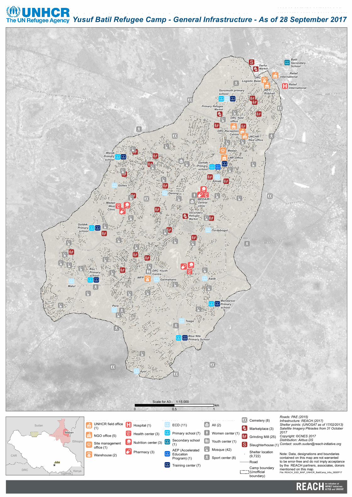
Darfur Market Primary Refugee Market Secondary Refugee Market DRC Logistic Base Medair LWF Office DRC Youth Centre DRC Reception Centre DRC field office WFP Rubhall WFP UNCHR filed office Relief international Medair West Clinic Relief international MEDAIR central clinic Werak Primary school Goldek Primary school Bau Primary school Gamak Primary school Batil Secondary School Blue Nile Primary School Mendarsol Primary school Goltes Malul Awiik Tordabogol Gurumuth primary school Garmahano Ayol Almak Taaga Pora Dereng UNHCR field office (1) NGO office (5) Site management office (1) Warehouse (2) Hospital (1) Health center (3) Nutrition center (3) Pharmacy (3) ECD (11) Primary school (7) Secondary school (1) AEP (Accelerated Education Program) (1) Training center (7) All (2) Women center (1) Youth center (1) Mosque (42) Sport center (8) Cemetery (8) Marketplace (3) Grinding Mill (25) Slaughterhouse (1) ! Shelter location (9,722) Road Camp boundary (Unofficial boundary) ! \ Maban Juba CAR Ethiopia Kenya Sudan Uganda DRC Yusuf Batil Refugee Camp - General Infrastructure - As of 28 September 2017 Roads: PAE (2015) Infrastructure: REACH (2017) Shelter points: (UNOSAT as of 17/02/2013) Satellite Imagery:Pléiades from 31 October 2017 Copyright: ©CNES 2017 Distribution: Airbus DS Contact: [email protected] Note: Data, designations and boundaries contained on this map are not warranted to be error-free and do not imply acceptance by the REACH partners, associates, donors mentioned on this map. 0 1 0.5 km 1:15,000 Scale for A3 - File: REACH_SSD_MAP_UNHCR_BatilCamp_Infra_28SEP17
Transcript of SOUTH SUDAN – Upper Nile – Maban County For …Gamak Primary school Batil Secondary School Blue...
Darfur Market
Primary RefugeeMarket
SecondaryRefugeeMarket
DRCLogistic Base
Medair
LWF Office
DRC YouthCentre
DRC ReceptionCentre
DRC fieldoffice
WFP Rubhall
WFP
UNCHRfiled office
Reliefinternational
MedairWest
Clinic
Reliefinternational
MEDAIR centralclinic
WerakPrimaryschool
Goldek Primaryschool
BauPrimaryschool
GamakPrimaryschool
BatilSecondarySchool
Blue NilePrimary School
MendarsolPrimaryschool
Goltes
Malul
Awiik
Tordabogol
Gurumuth primaryschool
Garmahano
Ayol
Almak
Taaga
Pora
Dereng
Administratio nUNHCR field office(1)NGO office (5)Site managementoffice (1)Warehouse (2)
Health facilitiesHospital (1)
Health center (3)
Nutrition center (3)
Pharmacy (3)
Educatio nECD (11)
Primary school (7)Secondary school(1)AEP (AcceleratedEducationProgram) (1)Training center (7)
Co mmunity facilitiesAll (2)
Women center (1)Youth center (1)
Mosque (42)Sport center (8)
Cemetery (8)
Marketplace (3)Grinding Mill (25)
Slaughterhouse (1)
!
Shelter location(9,722)RoadCamp boundary(Unofficialboundary)
!\
MabanUpperNile
Juba
CAR
Ethiopia
Kenya
Sudan
UgandaDRC
SOUTH SUDAN – Upper Nile – Maban Co untyYusuf Batil Refugee Camp - General Infrastructure - As of 28 September 2017
Fo r Humanitarian Purpo ses OnlyPro ductio n date: 24 No vember 2017
Roads: PAE (2015)Infrastructure: REACH (2017)Shelter points: (UNOSAT as of 17/02/2013)Satellite Imagery:Pléiades from 31 October2017Copyright: ©CNES 2017Distribution: Airbus DSContact: [email protected]
Note: Data, designations and boundaries contained on this map are not warranted to be error-free and do not imply acceptance by the REACH partners, associates, donors mentioned on this map.
0 10.5km
1:15,000Scale for A3 -
File: REACH_SSD_MAP_UNHCR_BatilCamp_Infra_28SEP17