Dhaka South City Corporation: Structure, Finance and Personal Management

South Forrestdale Industrial Area Local Structure Plan
(Stage 1) Lots 6, 8 and 200 Rowley Road, Forrestdale
APRIL 2021

i cdp | South Forrestdale Industrial Local Structure Plan (Stage 1)
South Forrestdale Industrial Area Local Structure Plan (Stage 1) Lots 6, 8 and 200 Rowley Road, Forrestdale
APRIL 2021
Prepared by. CDP Town Planning & Urban Design
2/464 Murray Street
PERTH WA 6000
p. +61 8 6333 1888
w. www.cdpaus.com.au
Prepared for. Rowley Developments
PO BOX 525
RIVERSTONE NSW 2765
In Collaboration with.
RPS Group
JDSi Consulting Engineers
Transcore
Bushfire Prone Planning
Plan E
DOCUMENT STATUS
Version Comment Prepared Reviewed Issued
1 Lodgement (RPS) - - 21/11/2020
2
2a
WAPC (Schedule of Modifications)
WAPC Minor Edits (Re-issued)
MT JH 07/04/2021
04/05/2021
DISCLAIMER & COPYRIGHT
This document was commissioned by and prepared for the exclusive use of our Client. It is subject to and issued in collaboration with the agreement between CDP and our Client.
CDP acts in all professional matters as a faithful advisor to its clients and exercises all reasonable skill and care in the provision of professional services. The information presented herein has been compiled from several sources using a variety of methods. Except where expressly stated, CDP does not attempt to verify the accuracy, validity or comprehensiveness of this document, or the misapplication or misinterpretation by third parties of its content.
This document cannot be copied or reproduced in whole or part for any purpose without the prior written consent of CDP.

This structure plan is prepared under the provisions of the City of Armadale Local Planning Scheme No. 4.
IT IS CERTIFIED THAT THIS STRUCTURE PLAN WAS APPROVED BY RESOLUTION OF THE WESTERN AUSTRALIAN PLANNING COMMISSION ON: 14 MAY 2021
Signed for and on behalf of the Western Australian Planning Commission
______________________________________________________________ an officer of the Commission duly authorised by the Commission pursuant to Section 16 of the Planning and Development Act 2005 for that purpose, in the presence of:
Witness
17 MAY 2021 Date
14 MAY 2031 Date of Expiry

iii cdp | South Forrestdale Industrial Local Structure Plan (Stage 1)
Table of Modifications.
Amendment No.
Summary of Amendment Amendment Type Date Endorsed by WAPC

South Forrestdale Industrial Local Structure Plan (Stage 1) | cdp iv
Executive Summary.
This Structure Plan applies to Lots 6, 8, 200 Rowley Road Forrestdale and represents ‘Stage 1’ of the South
Forrestdale Industrial Area covering a total area of 103 hectares. The Structure Plan has been prepared to
refine and implement the subdivision and development requirements associated with the City of Armadale
Schedule 8 Development Area No.46 provisions.
The proposed ‘General Industrial’ development comprising substantial lot sizes is an ideal and timely
addition to the Metropolitan South East region. The Structure Plan will aid in providing an industrial centre
which is well connected to intermodal freight facilities at the Welshpool-Kewdale industrial centre and are
ideally placed to take advantage of the potential synergies with major export oriented industrial centres
such as Kwinana and Latitude 32, located in the Southwest Metropolitan sub-region. To that end, the
Structure Plan provides for the development of general Industry logistic and storage warehouses as a
solution to cater for the growing e-commerce sector.
Item Data LSP Reference
Total Structure Plan Area 103.69 hectares Part 2, Section 1.2.2
Area of each land use proposed:
• Industrial
79.68 hectares
Part 2, Section 3.1
Estimated Number and % of Public Open Space:
• Open Space, Drainage & Vegetation Retention
13.26 hectares Part 2, Section 3.5
Road Widening:
• Rowley Road
13.97 hectares Part 2, Section 3.7
This Structure Plan comprises:
1 Part One - Implementation
This section contains the Structure Plan Map and outlines the purpose and intent of the Structure
Plan.
2 Part Two - Explanatory Section
This section contains the explanatory component of the Structure Plan, including background
information, and an explanation of the structure plan, including design methodology, relevance and
compliance with the applicable planning frameworks at the State and Local Government level.
This section also includes plans and maps in support of the Structure Plan.
3 Part Three - Appendices
This section contains all of the technical reports and studies in support of the Structure Plan, with the
level of detail contained within these reports and studies being commensurate with the context and
scale of the proposed Structure Plan.

v cdp | South Forrestdale Industrial Local Structure Plan (Stage 1)
Contents.
Part One - Implementation ............................................................................................................................................ 2
1. Structure Plan Area ............................................................................................................................................. 2
2. Operation .............................................................................................................................................................. 2
3. Subdivision & Development Requirements .................................................................................................... 2
3.1 Lot Design & Layout .......................................................................................................................................... 2
3.2 Environment & Landscape .............................................................................................................................. 2
3.3 Bushfire Management ....................................................................................................................................... 2
3.4 Servicing ................................................................................................................................................................. 2
3.5 Rowley Road Upgrade ..................................................................................................................................... 3
4. Other Requirements ............................................................................................................................................ 3
4.1 Western Power Easement .............................................................................................................................. 3
Plan 1 – Local Structure Plan ......................................................................................................................................... 4
Part Two - Explanatory Section ................................................................................................................................... 6
1. Planning Background .......................................................................................................................................... 6
1.1 Introduction & Purpose .................................................................................................................................... 6
1.2 Land Description ................................................................................................................................................. 6
1.3 Planning Framework ......................................................................................................................................... 11
2. Site Conditions & Constraints .......................................................................................................................... 14
2.1 Biodiversity & Natural Area Assets ........................................................................................................... 14
2.2 Landform ............................................................................................................................................................... 17
2.3 Groundwater........................................................................................................................................................18
2.4 Surface Water .....................................................................................................................................................18
2.5 Bushfire Hazard ..................................................................................................................................................18
2.6 Heritage ................................................................................................................................................................ 19
2.7 Opportunities & Constraints ........................................................................................................................ 19
3. Local Structure Plan .......................................................................................................................................... 21
3.1 Land Use ................................................................................................................................................................ 21
3.2 General Industrial............................................................................................................................................... 21
3.3 Interface................................................................................................................................................................. 21
3.4 Lot Sizes & Lot Yield ....................................................................................................................................... 23
3.5 Public Open Space ........................................................................................................................................... 23
3.6 Retention of On-Site Vegetation ............................................................................................................... 23
3.7 Access & Movement Networks .................................................................................................................. 26

South Forrestdale Industrial Local Structure Plan (Stage 1) | cdp vi
3.8 Water Management ........................................................................................................................................ 26
3.9 Infrastructure Coordination, Servicing & Staging ............................................................................... 27
4. Conclusion .......................................................................................................................................................... 29
Appendices.
. Certificates of Title
. Engineering Servicing Report
. Transport Assessment Report
. Environmental Assessment Report
. Local Water Management Strategy
. Bushfire Management Plan
. Landscape Concept Masterplan & Irrigation Strategy Plan
. Geotechnical Report
List of Figures.
Figure 1. Location Plan Figure 2. Aerial
Figure 3. TPS Zoning Figure 4. MRS Zoning Figure 5. Opportunities & Constraints
Figure 6. Concept Plan Figure 7. Wetland & Public Open Space Figure 8. Indicative Road Reserves

Part One - Implementation SOUTH FORRESTDALE INDUSTRIAL AREA LOCAL STRUCTURE PLAN (STAGE 1)

South Forrestdale Industrial Local Structure Plan (Stage 1) | cdp 2
Part One - Implementation
1. Structure Plan Area
This Structure Plan is applicable to Lots 6, 8, and 200 Rowley Road, Forrestdale (the subject site) and
comprises 103 hectares (ha) which is bordered by rural lots to the north, Tonkin Highway to the east,
Rowley Road and existing Rural Residential allotments to the south and rural allotments to the west. The
subject site represents ‘Stage 1’ of the South Forrestdale Industrial Area.
2. Operation
This Local Structure Plan comes into effect on the day on which it is approved by the Western Australia
Planning Commission (the Commission) and is valid for a period of 10 years from that date, or another
period as determined by the Commission in accordance with Schedule 2 of the Planning and Development
(Local Planning Scheme) Regulations 2015.
3. Subdivision & Development Requirements
The South Forrestdale Industrial Area Local Structure Plan (Stage 1) [‘Structure Plan’] contained within Part
One has been presented to provide an appropriate level of information relevant to the site for the level of
planning that has been undertaken. It shall provide a guide to future subdivision and zoning within the
Structure Plan area.
The following requirements will be applicable to the subdivision of the subject land:
3.1 Lot Design & Layout
a) Subdivision shall generally be in accordance with the Structure Plan.
b) The minimum lot size shall be 2,000m2.
3.2 Environment & Landscape
a) The subdivider shall prepare and submit an Urban Water Management Plan (UWMP) for any
subdivision application applicable to the subject land. A condition of subdivision will require the
implementation of the approved UWMP to the satisfaction of the Local Government and the
Department of Water and Environmental Regulation.
b) The subdivider is required prepare a Wetland Management Plan (WMP) for the entire Resource
Enhancement Wetland traversing the western boundary of the Structure Plan area. A condition of
subdivision approval will require the implementation of the approved WMP to the satisfaction of
the Local Government and the Department of Water and Environmental Regulation.
3.3 Bushfire Management
a) As a condition of subdivision, the subdivider shall place a section 165 (Planning and Development
Act 2005) notification on the Certificate(s) of Title advising landowners that the lots are located
within a bushfire prone area and may be subject to a bushfire management plan.
3.4 Servicing
a) As a condition of subdivision, the subdivider will be required to connect each proposed lot to
reticulated water, reticulated waste water and underground power.

3 cdp | South Forrestdale Industrial Local Structure Plan (Stage 1)
3.5 Rowley Road Upgrade
a) The intersection treatments with Rowley Road are to be resolved prior to the subdivision of the
subject area, to the satisfaction of Main Roads WA.
b) The land required for widening of Rowley Road will be ceded free of cost as a condition of
subdivision.
4. Other Requirements
4.1 Western Power Easement
a) The western portion of the site is encumbered by an easement to the State Energy Commission of
Western Australia (Western Power). This easement traverses the Public Open Space containing the
Resource Enhancement Wetland (REW). Any proposal for the use and/or development of land
encumbered by the easement shall be referred to Western Power for comment and shall:
i. Demonstrate compliance with the conditions of the easement as specified by Western Power;
and
ii. Incorporate appropriate controls of built form and other land practices to ensure the use and
development will not unreasonably encroach upon the easement to the satisfaction of the
responsible authority on the advice of Western Power.
South Forrestdale Industrial Stage 1 Local Structure Plan | cdp 4
Plan 1 – Local Structure Plan
South Forrestdale Industrial Local Structure Plan (Stage 1) | cdp 5
Part Two - Explanatory Section SOUTH FORRESTDALE INDUSTRIAL AREA LOCAL STRUCTURE PLAN (STAGE 1)

South Forrestdale Industrial Local Structure Plan (Stage 1) | cdp 6
Part Two - Explanatory
Section
1. Planning Background
1.1 Introduction & Purpose
This Local Structure Plan (LSP) and report
have been prepared on behalf of the
landowner, in accordance with the
WAPC’s Structure Plan Preparation
Guidelines and the City of Armadale’s
Town Planning Scheme No.4 (LPS4)
provisions under Schedule 8 Development
Area No.46.
This LSP has been prepared by CDP with
technical inputs from a multidisciplinary
team comprising:
• RPS - Environmental Assessment
Report (EAR)
• RPS - Local Water Management
Strategy (LWMS)
• Bushfire Prone Planning - Bushfire
Management Plan (BMP)
• JDSI Consulting Engineers -
Engineering Servicing Report
• Transcore - Traffic Impact
Assessment
• Plan E - Landscape Concept
Masterplan.
1.2 Land Description
1.2.1 Location
The subject land is located within the City
of Armadale and abuts the municipal
boundary of the Shire of Serpentine-
Jarrahdale to the south. The site is located
south-west of the Armadale city centre,
north-west of the Byford townsite,
approximately 25 kilometres southeast of
the Perth CBD and 22 kilometres east of
the Fremantle Town Centre. The land has
convenient access to the regional road
network via Tonkin Highway and Rowley
Road (refer Figure 1 – Location).
The subject site is generally bound by
Tonkin Highway and Rowley Road.
1.2.2 Area & Land Use
The LSP encompasses a total land area of
103.69 hectares (refer Figure 2 – Aerial).
The subject site represents Stage 1 of the
South Forrestdale Industrial Area.
The subject land has previously been
cleared and is currently stocked with
cattle and horses. The subject land has
been grazed for over 40 years. This
prolonged period of grazing has resulted
in the understory of the entire property
becoming completely degraded. In
addition, artificial drainage channels have
previously been formed, which appears to
have altered the hydrology of the subject
land.
1.2.3 Surrounding Land Uses
Bounded by Tonkin Highway to the east
and Rowley Road to the south, the site is
surrounded by rural land with rural living
properties south of Rowley Road (refer
Figure 1 – Location).
Adjacent landholdings to the west and
north are zoned “Industrial” in the MRS
(Amendment 1340/57 gazetted October
2019 erfers) and “Rural Living” under the
CoA TPS No. 4. These landholdings will
ultimately form ‘Stage 2’ of the South
Forrestdale Industrial Area and developed
under guidance of a separate Local
Structure Plan.
Areas east of Tonkin Highway are included
under the Wungong Urban Water
Redevelopment Scheme, which is
proposed for residential and urban
development, and areas south of Rowley
Road are zoned as ‘Special Rural’ in the
Shire of Serpentine-Jarrahdale’s TPS No. 2.

7 cdp | South Forrestdale Industrial Local Structure Plan (Stage 1)
Figure 1: Location Plan
South Forrestdale Industrial Local Structure Plan (Stage 1) | cdp 8
Figure 2: Aerial

9 cdp | South Forrestdale Industrial Local Structure Plan (Stage 1)
Figure 3: TPS Zoning
South Forrestdale Industrial Local Structure Plan (Stage 1) | cdp 10
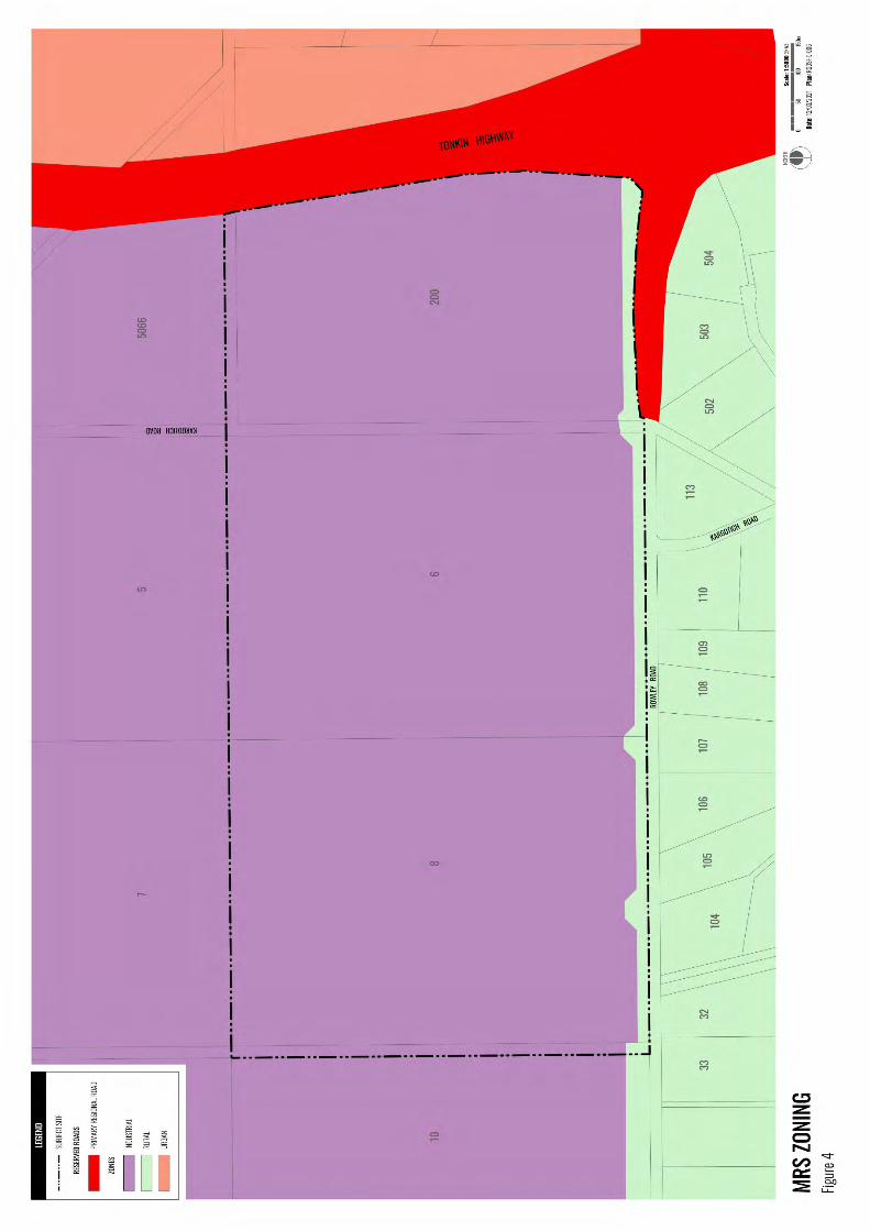
Figure 4: MRS Zoning

11 cdp | South Forrestdale Industrial Local Structure Plan (Stage 1)
Rowley Road is identified as a future
Primary Freight Route in State Planning
Policy 5.4 Road and Rail Transport Noise.
MRS Amendment 1240/41 applicable to
the Stage 1 Industrial development
required a portion of the site parallel to
Rowley Road to retain its ‘Rural’ zoning to
accommodate the necessary land
requirements for future widening of
Rowley Road.
The site is near the Forrestdale Lake
Nature Reserve (A Class Reserve) and its
associated Bush Forever Site No. 345,
located approximately 500 metres to the
north-west. Forrestdale Lake is listed as a
RAMSAR wetland and is of international
importance.
Within a 5 km radius of the site, the
following industrial land use sites can be
found (refer Figure 5 – Opportunity &
Constraints):
• Armadale landfill and recycling centre
with a 1 km buffer;
• four poultry farms with a 500 m
buffer;
• a sewage treatment plant with a
500 m buffer; and
• a natural gas pipeline with a 300 m
buffer.
1.2.4 Legal Description & Ownership
The legal description and ownership
details as stated on the current Certificate
of Title, are as follows (refer Appendix A –
Certificate of Title):
• Lot 6 on Deposited Plan 226007,
Volume 709, Folio 150
• Lot 8 on Deposited Plan 226007,
Volume 709, Folio 150
• Lot 200 on Deposited Plan 54228,
Volume 2684, Folio 509
1.3 Planning Framework
1.3.1 Zoning & Reservations
Metropolitan Region Scheme
The subject land is zoned ‘Industrial’ under
the MRS and abuts a ‘Primary Regional
Road’ reserve along its eastern and
portion southern-eastern boundary, and
local road Rowley Road to the south (refer
Figure 4 – MRS Zoning).
The site was formally zoned ‘Rural’ under
the MRS and ‘Rural Living’ under the City
of Armadale TPS No. 4. Most of the site
was subsequently rezoned to ‘Industrial’
under the MRS in October 2012 (MRS
Amendment 1240/41, South Forrestdale
Industrial Area), with a minor portion of
the site adjacent to Rowley Road
remaining as ‘Rural’ (refer Figure 4 – MRS
Zoning). This Amendment was approved
by the Minister for Planning and was
published in the Government Gazette on
10 September 2014.
The MRS Amendment report states that:
“The proposed industrial zoning is
intended to allow for primarily
general / service industrial
development of the land as well as
some commercial / showroom
development as determined through
a local scheme amendment, detailed
structure planning and subdivision
approval.”
City of Armadale Local Planning
Scheme No. 4
Amendment 73 to the City of Armadale
TPS No. 4 rezoned the majority of site to
“Industrial Development”; gazetted on 16
December 2016 (refer Figure 3 – TPS 4
Zoning). To accord with the MRS, a minor
portion of the site adjacent to Rowley
Road remained as “Rural Living”.
The zoning designates land for future
industrial development and provides a
basis for future detailed planning in

South Forrestdale Industrial Local Structure Plan (Stage 1) | cdp 12
accordance with Schedule 8 Development
(Structure Planning) Areas of the Scheme.
The provisions of this Structure Plan and
accompanying specialist reports conforms
to the provisions established under
Schedule 8 –No.46 ‘South Forrestdale
Industrial Centre’, namely:
• Subdivision and development should
be generally consistent with a
Structure Plan for Development Area
46 – Rowley Road Industrial Area to
be prepared pursuant to Part 4 of the
Deemed Provisions (set out in the
Planning and Development (Local
Planning Schemes) Regulations 2015
Schedule 2).
• A transport assessment shall be
prepared in accordance with
applicable WAPC Guidelines.
• The Structure Plan shall make
adequate provision for the
rehabilitation and protection of
adjoining Conservation Category
Wetlands, Bush Forever land and
Regional Parks and the Resource
Enhancement Wetland on Lot 8
Rowley Road to the satisfaction of
the EPA and the local government.
• The Structure Plan shall:
− include a servicing report detailing
load demand and indicative
network augmentation /
reinforcement requirements for
review and ratification by Western
Power;
− delineate the Western Power
registered easement and
transmission infrastructure
include detailed designs and
information for review,
assessment and written
consent of Western Power to
any proposals below, if
applicable, within the
registered easement, in
accordance with standard
easement conditions:
• Landscaping plans
(including mature heights
and location of species);
• Ground level changes;
• Permanent structures;
• Drainage plans;
• Conservation controls.
1.3.2 Planning Strategies
Perth & [email protected] Million & South
Metropolitan Peel Sub-Regional
Planning Framework
The Perth and [email protected] Million document
provides strategic guidance to
government agencies and local
governments on land use, land supply,
land development, environmental
protection, infrastructure investment and
the delivery of physical and
community/social infrastructure for the
Perth and Peel regions. It makes the case
for change from a business as-usual
perspective to a more considered,
connected and consolidated urban form. It
links the four frameworks for each sub-
region (North-West, North-East, Central
and South Metropolitan Peel) and
encourages the consideration of new
urban growth opportunities.
The South Metropolitan Peel Sub-Regional
Planning Framework forms part of the
Perth and [email protected] Million strategic suite
of planning documents. Future areas for
urban and industrial development have
been determined in conjunction with the
State Government’s Strategic Assessment
of the Perth and Peel Regions, in order to
protect areas which have significant
environmental value.
The Framework identifies the subject site
as a non-strategic industrial proposal and
the LSP therefore contributes to the
implementation of the Frameworks’

13 cdp | South Forrestdale Industrial Local Structure Plan (Stage 1)
recommendations. The Frameworks
identifies that the two Forrestdale
industrial area precincts (Forrestdale and
South Forrestdale) hold potential
connections to freight network
connections linking with the Perth Airport,
Outer Harbour and Kewdale intermodal
transfer facilities.
The Frameworks states the network of
industrial sites, including the subject site,
considers optimal proximity to workforce
and service catchments, compatibility with
adjacent land uses, accessibility to the
freight network and, where possible,
proximity to intermodal transfer facilities.
The location of the subject site on key
east-west transport routes will provide a
local employment option for people within
the south-eastern sector.
Land to north and west of the subject site
which includes Stage 2 is identified as
‘Industrial Expansion’ in the Framework.
Economic and Employment Lands
Strategy
The Economic and Employment Lands
Strategy (EELS) was developed as a
response to a predicted shortfall in
industrial land supply. The strategy is
guided by the aforementioned themes
outlined in Perth and [email protected] Million and
focuses on the needs of general and light
industry in terms of areas, type, and
location of land in the context of a review
of current supply and an evaluation of
suitable new locations. From this, EELS
forms the strategy that guides the supply
and development of industrial land to
meet the requirements of a growing
population for the next 20 years and
beyond.
The South Forrestdale industrial precinct
has been identified as a possible future
medium term industrial site with a 4 to 10
years planning timeframe. The precinct
which includes both the subject site and
Stage 2 covers a total land area of
approximately 354 hectares, extending
northwards to the edge of Bush Forever
Area 345 and westward to adjoin existing
special rural development.
The LSP seeks to undertake the first stage
of development, covering 103 hectares in
the south-east corner of the South
Forrestdale precinct, and is consistent with
the intent of the Strategy. The uses
proposed within the LSP are in accordance
with the EELS, contributing to
employment for the Wungong Project
residential population to the east of Tonkin
Highway.
1.3.3 Planning Policies
WAPC State Planning Policy 4.1 Sate
Industrial Buffer Policy
State Planning Policy 4.1 (SPP4.1) provides
protection to industrial areas through a
consistent approach to land-use buffer
definition, whilst considering the safety
and amenity of surrounding uses and the
interests of existing landowners, residents
and businesses.
Section 3.1 of SPP4.1 states that the impact
of light, service industrial and technology
parks uses can generally be contained on
site through landscaping and appropriate
setbacks. Section 3.2 states that offsite
buffers may be required for more intensive
uses, including resource processing and
general industry, subject to environmental
and planning criteria.
Whilst the uses proposed within the
structure plan are ‘General Industrial’ uses
it is not considered that any land-use
buffers are required for development
outside of the structure plan area as the
existing Primary Regional Road of Tonkin
Highway and future 70 metre Primary
Regional Road Reserve of Rowley Road
will provide suitable separation.
In addition, the proposed future land use
nature is reflective of a technology and
logistic park in lieu of noxious or
South Forrestdale Industrial Local Structure Plan (Stage 1) | cdp 14
hazardous industry and the use of
setbacks in this instance is most effective,
particularly when combined with
landscaping, for reducing the land use
impacts to an acceptable level.
WAPC Development Control Policy
4.1 Industrial Subdivision
Development Control Policy 4.1 (DCP4.1)
provides guidance in the determination of
industrial subdivision applications in
relation to matters of the design and
shape of industrial lots, road layout,
servicing, and open space requirements.
The policy measures of DCP4.1 have been
considered, and future subdivisions will be
assessed against DCP4.1.
City of Armadale Local Planning
Policy 4.2: Advertisements (Signage)
The City’s Local Planning Policy 4.2
(PLN4.2) establishes a framework for
regulating the design and placement of
signage in the City of Armadale.
Any signage proposed for ‘General
Industry’ development within the LSP area
shall be subject to the standards
prescribed in PLN4.2.
2. Site Conditions & Constraints
RPS prepared a comprehensive Environmental
Assessment Report (EAR) to support the
implementation of the LSP (refer Appendix D –
Environmental Assessment report). The purpose
of this report is to provide:
1. Review of the existing environment and
address key environmental factors that
may be impacted as a result of future
development;
2. Outline the management measures that
will be adopted to mitigate any potentially
significant environmental impacts from
future development; and
3. Facilitate the approval of the LSP with the
City of Armadale and the Western
Australian Planning Commission (WAPC)
by providing a land use framework to
coordinate residential subdivision and
development.
In addition, Bushfire Prone Planning have
prepared a Bushfire Management Plan to
accompany the LSP (refer Appendix F – Bushfire
Management Plan).
An opportunity and constraints plan (refer Figure
5 – Opportunities and Constraints) has also been
prepared to illustrate the main issues discussed in
this section.
2.1 Biodiversity & Natural Area Assets
2.1.1 Remnant Native Vegetation
The site is mostly devoid of native
vegetation due to historical cattle grazing.
The minor areas of remnant native shrubs
and sedges within the site are
concentrated in and around the winter-
wet depressions, which have likely
persisted despite grazing pressures due to
being unpalatable. The RPS field
investigation categorised the vegetation
into two broad vegetation types.
• V1 - Scattered Melaleuca
rhaphiophylla and M. preissiana
remnant trees over a weedy
understorey of exotic pasture
grasses and scattered dense clumps
15 cdp | South Forrestdale Industrial Local Structure Plan (Stage 1)
of Zantedeschia aethopica (Arum
Lily). This unit covered the majority
of the site.
• V2 - Melaleuca rhaphiophylla and M.
preissiana Woodland over Kunzea
glabrescens and Astartea affinis
Shrubland to Closed Shrubland, over
Dielsia stenostachya and mixed
exotic pasture grasses. This unit is
associated with the RE wetland in
the west of the site.
A third broad vegetation type was
represented immediately outside the site
within the road reserve portion of the
mapped REW (Figure 1):
• V3 - Melaleuca rhaphiophylla closed
Woodland over Astartea affinis and
Pteridium esculentum shrubland over
Zantedeschia aethopica, Juncus
pallidus, Lepidosperma sp. and
Dielsia stenostachya
Herbland/Sedgeland.
Due to the degraded nature of the site
RPS considers that the remnant vegetation
within the V1 vegetation unit described
above is no longer representative of its
original floristic community type due to
the complete absence of a native mid or
understorey.
The implementation of the LSP will result
in the following outcomes:
• A minimum of 4.57 ha of remnant
vegetation will be retained within the
REW (UFI 15796) and its 30m
proposed buffer; and
• The LSP Stage 1 design will require
the clearing of approximately 10.3 ha
of the remnant vegetation in Lots 6, 8
and 200 outside of the proposed
buffer (subject to detailed landscape
and engineering design).
The potential impact on the cleared native
vegetation is due to accommodating
development requirements such as entry
roads, local roads, industrial development
and stormwater detention/ open space.
The engineering works will require fill to
achieve separation of the finished floor
levels of the proposed industrial
development from the groundwater table
and to improve the geotechnical
classification of the site. Approximately 1.5
m clearance is required to the Average
Annual Maximum Groundwater Level
(AAMGL), as such it is unlikely to retain
native vegetation outside of the REW
proposed buffer.
The loss from clearing the native
vegetation outside of the REW’s proposed
buffer is minimal, as it is no longer
representative of its original FCT and it is
considered to be in a ‘Completely
Degraded’ condition.
The best quality remnant native
vegetation, identified to be in ‘Degraded’
to ‘Good’ condition, will be retained within
the REW and proposed buffer.
This report found that the environmental
attributes and values of the site have been
accommodated within the LSP design,
and/or can be managed appropriately
through future subdivision and/or
development applications in accordance
with the relevant federal, state or local
government legislation, policies and
guidelines and best environmental
management practices. As such the
proposed future development will not
significantly impact upon the
environmental attributes of the site.
2.1.2 Fauna Habitat
The EAR details the Bioscience fauna
survey that was conducted and did not
find evidence of native species habitat,
due to the native vegetation’s highly
degraded state. This conclusion was
shared in Western Wildlife’s findings,
however they advised that rehabilitation
of the REW (UFI 15796) and its buffer in
Lot 8 may offer future habitat to fauna in
particular birds and reptiles.
South Forrestdale Industrial Local Structure Plan (Stage 1) | cdp 16
Figure 5: Opportunities & Constraints

17 cdp | South Forrestdale Industrial Local Structure Plan (Stage 1)
RPS’s field investigation in 2014 assessed
the flora and vegetation’s ecological
values to determine if the site contained
any habitat suitable for conservation
significant fauna species. RPS found that
the site did not contain significant fauna
habitat that would support any
Threatened fauna species identified in the
desktop searches.
2.1.3 Bush Forever
Bush Forever identifies areas of regional
conservation value on the Swan Coastal
Plain portion of the Perth Metropolitan
Region with an aim to protect a
comprehensive representation of the
biological diversity on the Swan Coastal
Plain. Bush Forever Site No. 345 -
Forrestdale Lake and Adjacent Bushland,
Forrestdale is situated 500m north-west
to the site (refer Figure 5 – Opportunities
and Constraints).
2.2 Landform
2.2.1 Topography
The site is low lying and relatively flat at
24 m Australian Height Datum (mAHD).
Lot 200’s south-east corner and in minor
areas located on its western and northern
boundary is slightly higher at 25 mAHD.
2.2.2 Geology
The site is within the Swan Coastal Plain,
with the majority found in the Pinjarra
Plain system and a portion of Lot 8 in the
Bassendean Dunes system. The Pinjarra
Plain is characterised by poorly drained
plains and poorly defined stream channels
with moderately deep to deep sands over
mottled clays. These soils are typically
acidic and tend to be grey and yellow
duplex soils to a uniform bleached or pale
brown. The Bassendean Dunes is also
known for poorly drained plains, as its
siliceous sands are underlain by clay or an
iron-organic hardpan at depths generally
greater than 1.5m. These soils tend to be a
deep bleached grey, sometimes with a
pale-yellow subsurface soil layer.
Bassendean Sands over the Guildford
Formation underlie these systems.
Bassendean Sands typically consist of
white to grey quartz sands with minor
fines and negligible clay content. The
Guildford formation has complex layering
of soils from past erosion events where
material was transported via rivers and
streams and deposited in alluvium fans. It
is characterised by poor drainage due to
the low permeability of its clayey sub-
surface layers. This results in surface
inundation when rainfall infiltration
exceeds the soil’s capacity to retain or
percolate through.
The geology at the site is listed below:
• S10 – SAND – as S8 over sandy clay
to clayey sand of the Guildford
formation of eolian origin.
• Sp1 – PEATY SAND – grey to black,
fine to medium-grained, moderately
sorted quartz sand, slightly peaty of
lacustrine origin.
• S9 – SAND – yellowish brown,
medium to coarse-grained, angular to
sub-rounded quartz, some fine
grained pisolitic laterite little fines of
lacustrine origin.
• Cs – SANDY CLAY – white-grey to
brown, fine to coarse-grained,
subangular to rounded sand, clay of
moderate plasticity, gravel and silt
layers near scarp, of alluvial origin.
2.2.3 Acid Sulfate Soils
The Department of Environment
Regulation (DER) Acid Sulfate Soil (ASS)
risk mapping shows the site has been
classified as having mostly a moderate to
low risk of Acid Sulfate Soils (ASS)
occurring within 3m of the natural soil
surface and activities disturbing soils at
depths greater than 3m carry a high to
moderate risk of disturbing ASS. However,
there are three small pockets in which a

South Forrestdale Industrial Local Structure Plan (Stage 1) | cdp 18
high to moderate risk of ASS occurring
within 3m of the natural soil surface.
Given the areas of high to moderate ASS
risk and the shallow groundwater table
onsite, an ASS investigation is likely will be
required prior to any dewatering and
excavation works.
2.2.4 Contaminated Sites
A search of the Department of Water and
Environmental Regulation’s (DWER)
Contaminated Sites Database on 10
September 2019 did not record any
matches for the site.
The sites’ agricultural practises may have
included the use of chemicals, such as
pesticides and herbicides, however the risk
of residual contamination is considered
low.
2.3 Groundwater
The site is underlain by the Superficial
Armadale, Leederville and Yarragadee
North Aquifers. Groundwater monitoring
has been undertaken in 2010, 2011, 2012
and 2019. Groundwater levels within the
greater LSP area ranges from 24.8 mAHD
to 21.4 mAHD, with a generally flow of
groundwater towards the south boundary.
The calculated AAMGL for the subject site
ranges from 24.4 m AHD to 21.2 mAHD.
The pre-development AAMGL is at or
above land surface for the north-western
part of the subject site where the REW is
located.
2.4 Surface Water
2.4.1 Wetlands
The REW was previously identified as a
Conservation Category wetland (CCW).
On 26 August 2010, a modification request
was sent to the DEC to change its
classification. On 16 December 2010, the
DEC advised that due to the condition of
vegetation and the wetland’s limited
ability to naturally regenerate, it would be
re-classified as Resource Enhancement
and its boundary adjusted. The REW
requires a proposed buffer of 30 m from
its boundary. It is likely that a Wetland
Management Plan will need to be prepared
and implemented at subdivision stage, in
concert with specific water management
planning.
2.4.2 Drainage
There are several poorly defined creeks
and depressions across the site, forming
seasonally inundated areas. The larger
LSP areas partially drains north towards
for the Forrestdale Main Drain (FMD) (and
Forrestdale Lake), and south towards the
Birrega Main Drain (BMD). The subject site
(104 ha) drains south towards the BMD
with approximately 190ha of external
catchment draining through the subject
site. A pre-development stormwater
model was created for the subject site on
XPSWMM in order to estimate the flow
regime and pre-development flows going
to the BMD.
2.5 Bushfire Hazard
Bushfire Prone Planning prepared the
Bushfire Management Plan (BMP) to
support the LSP (refer Appendix F –
Bushfire Management Plan). A summary of
the findings and management measures is
provided below.
The BMP found that the proposal, as set
out in this Plan has addressed the
applicable legislation, policy, standards
and guidelines including the four elements
of the Bushfire Protection Criteria of
Location, Siting and Design, Vehicular
Access and Water Supply. The
determination is that the proposal can
meet all the requirements against the
Bushfire Protection Criteria, the decision
maker’s assessment of this proposal is to
be on the basis of it being able to meet the
acceptable solutions for all four elements
once construction and any applicable
landscaping is complete.

19 cdp | South Forrestdale Industrial Local Structure Plan (Stage 1)
The vegetation within the proposed
development boundary (predominantly
Grassland) has been considered and it is
expected that in the future, this vegetation
will be maintained in a low threat state. It
will meet AS3959-2018 s2.2.3.2
requirements and will continue to be
maintained in a low threat state as
stipulated in the City of Armadale
Firebreak Notice.
The proposed Resource Enhancement
Wetland 30m buffer, Stormwater
detention and Open Space areas located
at Lot 8 has also been considered. The
ability for the proposed development to
achieve a BAL-29 or lower for future
buildings is reliant on the future
management of this vegetation in
perpetuity. It is a requirement for these
areas to continue to be maintained in a
way that will not increase the risk of a
bushfire to future buildings within the
proposed development.
Furthermore, it is expected that once
development and any applicable
landscaping has been completed,
indicative BAL ratings of BAL-29 or less
can be achieved for each of the proposed
lots.
It should be noted that, based on the
proposed general industrial land use, there
are no Building Attack Level (BAL)
considerations required under Australian
Standard 3959-2009 (AS3959); however,
areas within declared bushfire prone areas
will require further bushfire risk
assessment to support any future
subdivision or development stage to
determine the level of bushfire risk
mitigation to be implemented to comply
with SPP 3.7.
2.6 Heritage
2.6.1 Aboriginal Heritage
A search of the Department of Planning,
Lands and Heritage’s Aboriginal Heritage
Inquiry System undertaken on 4 October
2019 identified that no Registered or Other
Heritage sites are located within site.
2.6.2 Natural & Historic Heritage
A search of the Heritage Council’s Inherit
database and the City of Armadale’s
Municipal Heritage Inventory (CoA 2008),
which was reviewed in 2019 (CoA 2019),
were undertaken on 4 October 2019 with
no matches recorded for the site.
2.7 Opportunities & Constraints
This LSP has evolved from higher level
planning documents, including the EELS
and the Frameworks. As such, the
opportunities and constraints for the
subject site are well known and have been
clearly delineated in the strategies. A
summary of the context and constraints
for the subject site is provided below.
2.7.1 Opportunities
Land Ownership
The subject site comprises one private
landowner consortium ensuring an
integrated planning process and
development outcome.
Accessibility
The site has effective transport linkages
with routes such as Tonkin Highway,
Rowley Road, Nicholson Road-Armadale
Road and Heavy Haulage routes, therefore
ensuring the site has access to an
appropriate road network for both freight
and employment within the area.
Employment
Existing residential development lies
within close proximity to the subject site
with residential development underway as
part of the Wungong Urban Master Plan.
The development of the broader South
Forrestdale Industrial precinct is expected
to provide employment for the additional
120,000 people that will ultimately reside
in the residential growth areas of Byford,

South Forrestdale Industrial Local Structure Plan (Stage 1) | cdp 20
Haynes, Hilbert, Harrisdale and Piara
Waters.
In order to deliver jobs within the sub-
region employment growth needs to
better match the south metropolitan sub-
region’s labour force and demographic
profile. This would include manufacturing
and agricultural sectors as well as
knowledge-based employment that should
be strategically located at activity and
specialised centres. Additional industrial
land such as the subject site, located on
key east-west transport routes, will
provide a local employment option for
people within the south-eastern sector.
Population Growth
The population of the City of Armadale is
predicted to grow from 64,400 in 2011 to
95,110 by 2050.
Infrastructure
Westport
Fremantle Port currently serves as the
primary port for the metropolitan region.
The inner harbor, located in Fremantle, is
predicted to reach its capacity to handle
container freight by 2020. Subsequently,
The Westport Taskforce is developing a
plan to manage WA's growing freight
demands for the next 50 years and
beyond. The Taskforce is holistically
assessing a wide range of port and supply
chain options, while balancing
environmental, economic and social
outcomes. Westport is now assessing the
shortlist with the recommendations,
including the preferred port location,
design and cost, to be presented to
Government for consideration by the end
of 2019.
Rowley Road has been identified by the
Westport Taskforce as a major freight
route and will be upgraded from two lane
single carriageway to four lane dual
carriageway as a primary distributor. The
current upgrade concept has been
reflected on the proposed LSP Map.
Perth Airport
The Perth Airport Masterplan 2009
predicts that air freight at Perth Airport
will double by 2029, providing vital access
to both domestic and international export
markets. This presents a good opportunity
for future import/export businesses, given
that the airport is approximately 22km
north of the subject site which direct
linkage via Tonkin Highway.
2.7.2 Constraints
Resource Enhancement Wetland
The structure plan proposes to retain all
native vegetation within the REW and an
associated 30m buffer. The proposed
management of the remnant vegetation
will be through a Wetland Management
Plan, prepared and implemented at
subdivision stage to the satisfaction of the
City of Armadale.
Servicing
Water Corporation confirmed that the
subject area currently falls outside a
planned wastewater scheme catchment so
there is presently no sewerage
infrastructure near the development.
Notwithstanding, Water Corporation have
advised that the site is capable of being
serviced by reticulated water supply –
section 3.9 refers.
Water Corporation also advised that to
provide reticulated sewerage to the
development, a Water Corporation
standard reticulation network would need
to be installed within the proposed road
reserves.
The reticulation network would gravity
discharge to a Water Corporation owned
Wastewater Pump Station at a suitable
topographical low. A pressure main would
then be required to discharge the waste
water to a suitable connection point within
the Water Corporations existing sewerage
network. Water Corporation advised that a
suitable route for the pressure main will

21 cdp | South Forrestdale Industrial Local Structure Plan (Stage 1)
also be required, preferably within
established road reserves.
There is presently no water infrastructure
in or close to the proposed industrial area.
Notwithstanding, Water Corporation have
advised that the site is capable of being
serviced – section 3.9 refers.
The western side of the site is traversed by
a transmission line easement hosting one
132,000 Volt and two 330,000 Volt
circuits which are critical to the Western
Power high voltage network. Any
development near transmission lines needs
to be assessed by Western Power to
determine any restrictions which maybe
required e.g. building and structures
setbacks.
The current proposed structure plan over
Lots 6, 8 & 200 indicates a projected
ultimate load of 16.6 MVA for all stages of
the development. This load is based on
Western Power’s current minimum design
load requirement of 200kVA/ha. However,
the proposed development is anticipated
to comprise of industrial warehousing
which may require significantly less.
3. Local Structure Plan
3.1 Land Use
The proposed land uses consist of ‘General
Industrial’ as outlined in the proceeding
sections (refer to Plan 1 - Structure Plan
Map).
3.2 General Industrial
The proposed ‘General Industrial’ zoning
will enable the development of a wide
range of industrial premises that exhibit
appropriate design and environmental
performance in terms of amenity, noise,
emissions and generation of vehicular
traffic. The land use is considered to
facilitate the aggregation of storage,
distribution, transport and logistics
activities.
3.3 Interface
The WAPC’s SPP4.1 and DCP4.1 emphasise
the need for adequate buffering to
industrial land uses to ensure that
development is compatible with
surrounding commercial and/or residential
areas.
SPP4.1 states that the General Industry
zones should not have direct interface
with sensitive zones in local planning
schemes. An interface of compatible land
use zones and/or reserves should be
identified in local planning schemes to
ensure a compatible interface is achieved.
The LSP relies on the use of the 70m
Rowley Road reserve to ensure
appropriate separation is provided to any
sensitive uses, namely rural residential
allotments to the south. Rowley Road is
forecast to be ultimately upgraded from a
two-lane single carriageway to four lane
dual carriageway. As such the amenity and
impact of the ‘General Industry’ land use
will be mitigated by the future primary
distributor road.
The interface to the adjacent ‘Rural Living
20’ allotments which formed part of MRS
Amendment 1340/57 South Forrestdale
Industrial Area Stage 2 has considered
potential land use conflicts and will not
expose such land to adverse impacts. The
MRS ‘Industrial’ zoning gazetted in
October 2019 facilitates future
development of the amendment area for
industrial purposes.

South Forrestdale Industrial Local Structure Plan (Stage 1) | cdp 22
Figure 6: Concept Plan
23 cdp | South Forrestdale Industrial Local Structure Plan (Stage 1)
3.4 Lot Sizes & Lot Yield
The structure plan conceptually proposes
lot sizes ranging from 0.56ha for lots
abutting the POS up to ~8ha. The
predominant/average lot size across the
Structure Plan area is ~6.0ha (refer to
Figure 6 – Concept Plan), albeit potential
for much larger amalgamated sites is
earmarked by the proponent.
The large size of the proposed lots seeks
to provide sufficient space to
accommodate the future industrial
operations and building envisaged; namely
large logistics and e-commerce
distribution warehouses ranging from
20,000-50,000m2 in area. Due to the size
and scale of the proposed warehouses
suitable car parking and accompanied
landscaped areas will be required.
The EELs states that a survey of key
industry stakeholders have shown that,
with the increase of transport and logistic
oriented industry activities, lot sizes of
4,000 sqm or greater will continue to be
in greatest demand. The creation of large
allotments also provides the opportunity
and flexibility of re-subdivision to create
smaller lots on a case by case (market
demand) basis.
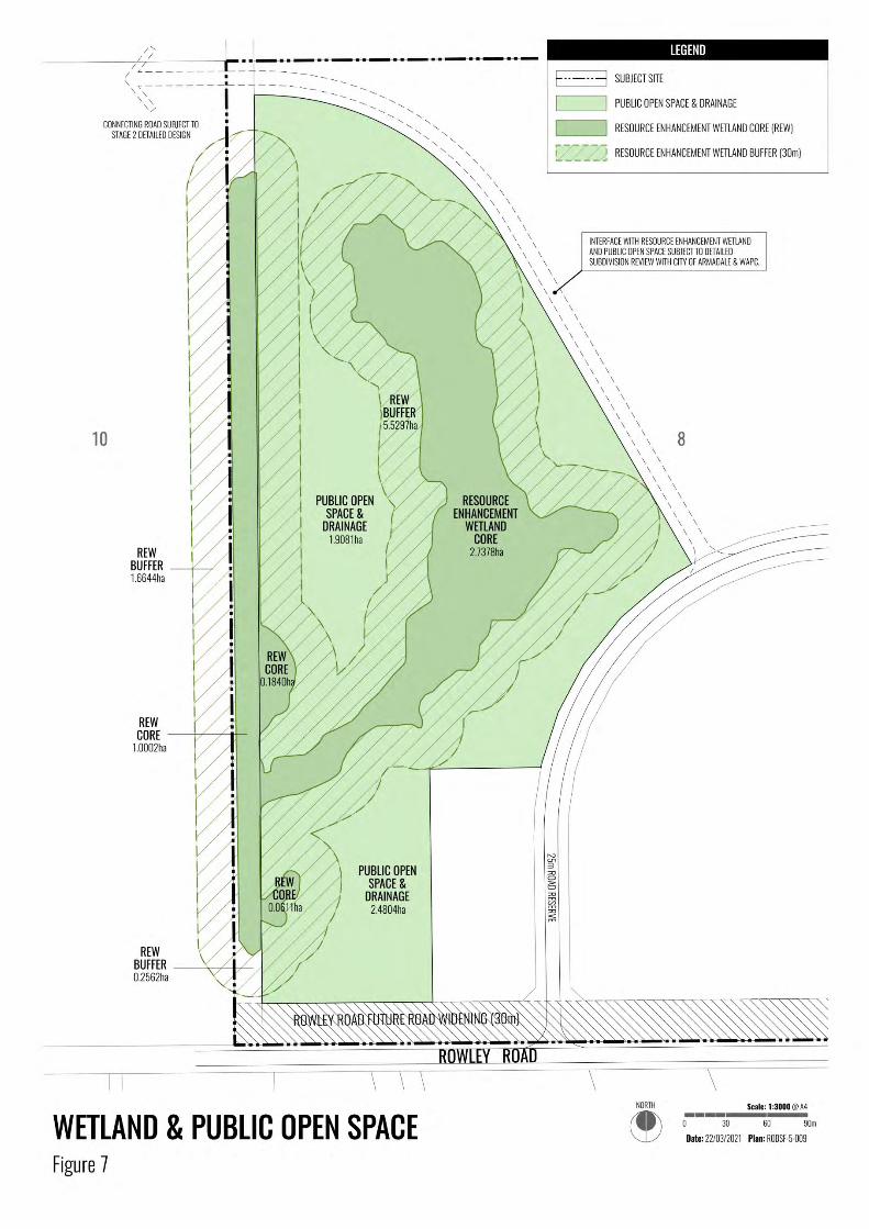
3.5 Public Open Space
A public open space (POS) area is
proposed along the western boundary of
the Structure Plan, this for the principal
purpose of Resource Enhancement
Wetland retention and associated 30m
buffer. The site will include vegetation
protection and onsite drainage and
complemented by pockets of public
amenity/breakout areas. The breakdown
of the POS area is illustrated under Figure
7 and Table 1.
The vision for the public open space
consists of passive recreation links utilising
the drainage lines traversing the site.
Native revegetation will be undertaken in
the wetland buffer area and a 2.5m wide
shared use pathway is proposed to line the
perimeter. Informal picnic and kick-about
spaces are proposed that will create a
useable open space area for people
working in the adjacent industrial
operations.
Table 1: Public Open Space Schedule
Land Component Approx ha.
REW Core 3.983 ha
REW Buffer (30m) – Stage 1 area 5.786 ha
POS/Stormwater Detention 4.388 ha
Total Public Open Space – Stage 1 14.1575ha
REW Buffer – within Stage 2 1.6644ha
Grand Total POS 15.8219ha
The POS is also encumbered by an
easement to the State Energy Commission
of Western Australia (Western Power).
Planting in the easement will comprise low
groundcover plantings to maintain
maintenance access to Western Power
standards.
3.6 Retention of On-Site Vegetation
A minimum of 4.57 ha of remnant
vegetation is proposed to be retained
within the POS area. The best vegetation
is identified in the REW and buffer, and is
in a ‘Degraded to Good’ condition with an
overstory of Melaleuca rhaphiophylla and
M. preissiana over Kunzea glabrescens and
Astartea species. The REW’s understory is
disturbed and dominated by pasture grass
and Zantedeschia aethiopica (Arum Lily).
Melaleuca and Kunzea species were noted
as naturally generating.
Should opportunity arise to retain
vegetation in road reserves or landscaping
areas within the broader development
sites, then endeavours will be made
towards retention. The retention of
additional vegetation will however be
highly dependent on detailed engineering
design factors, including urban stormwater
(hydrology) design considerations and
necessary clearance (site fill) above the
average natural ground water levels.
South Forrestdale Industrial Local Structure Plan (Stage 1) | cdp 24
Figure 7: Wetland & Public Open Space

25 cdp | South Forrestdale Industrial Local Structure Plan (Stage 1)
Figure 8: Indicative Road Reserves

South Forrestdale Industrial Local Structure Plan (Stage 1) | cdp 26
3.7 Access & Movement Networks
A Transport Assessment Report has been
prepared by Transcore (attachment
Appendix 5 refers). The report as
presented is based on the advertised
version of the Structure Plan, inclusive an
additional road traversing the eastern
permitter of the POS and potentially
connecting to the future Stage 2 industrial
development.
Whilst this road is not included in the final
Structure Plan Map (Plan 1) and Concept
Plan (Figure 6), traffic modelling has been
undertaken to rationalise the potential
traffic volumes should this road connect
the two industrial stages. As such, outlined
below is a summary of the key findings:
• It is estimated that the ‘warehousing’
area (Stage 1 comprising Lots 6, 8
and 200) would ultimately generate
traffic flows of 8,900 vehicles per day
(vpd) and the Stage 2 ‘general
industrial’ area would potentially
generate a further 16,700vpd.
• Access into this industrial structure
plan area is proposed to be served by
two new multi-lane roundabouts on
Rowley Road (at Kargotich Rd south
and at Blair Road) and a new left in /
left out intersection approximately
midway between those two
roundabouts. These access
arrangements are consistent with
planning for future upgrade of
Rowley Road by the DPLH and the
Westport Taskforce.
• The upgrading of Rowley Road to
industrial standard may be the
subject of a DCP guided by the City
of Armadale, or a Deed of Agreement
between Stage 1 and 2 landowners.
• The standard type of industrial road
within the proposed structure plan is
anticipated to be a 25m road reserve
with 10m road pavement width in
accordance with Policy DC4.1 (Figure
8 refers). Road reserves up to 30m
may apply subject to the final
drainage strategy (road-side swales)
and need for any on-street parking.
• The two main entry roads into the
structure plan area are anticipated to
carry traffic volumes in the 7,000 to
15,000vpd range of an Integrator B
road.
There is potential for these roads to
include a central median of 3 to 6m
width and two 5m carriageways
within the standard industrial road
reserve of 25m. Inclusion of central
medians will be subject to detailed
engineering and urban stormwater
management planning.
3.8 Water Management
A Local Water Management Strategy has
been prepared by RPS to support the LSP
and provide a structure from which
subsequent development can occur,
consistent with an integrated water cycle
management approach (refer to Appendix
E – Local Water Management Plan).
The following design criteria are adopted
in the drainage strategy and preliminary
drainage design:
• Maintain pre-development peak flow
rates from the site
• Retain 10 year ARI rainfall within Lots
• Habitable floor levels at least 0.3 m
above the 1% AEP flood level of the
urban drainage system
• Habitable floor levels at least 0.3 m
above 1% AEP flood level on the road
reserve
The stormwater drainage design
demonstrates that the land is capable of
managing stormwater for all events up to
the 1% AEP event. Rainfall up to and
including the 10 year ARI will be retained
within the lots using basins and/or
underground storage. Roadside swales will
be designed to cater for flows up to 1 in 10
year ARI rainfall events, while greater than
1 in 10 year will be conveyed via overland

27 cdp | South Forrestdale Industrial Local Structure Plan (Stage 1)
flow through the road network, and via
open channels running along the northern
and southern boundary of the subject site.
The western part of the site, which
includes the REW, will act as flood storage
for the 1 in 100 year ARI event, where
flows will be controlled by Rowley Road
and the culverts going under it. Controls
used to improve stormwater quality will
roadside swales, open channels and
stormwater retention systems on lots. The
use of native vegetation where
practicable, minimal fertiliser application
and soil amendment in major drainage
areas will assist with the management of
groundwater and surface water quality.
Subsoil drains will be installed in road
reserves and within the proposed lots, and
subsoil flows will be directed into the REW
via the road reserve and/or the open
channels. The CGL will been set according
to DoW (2013) Water Resource
Considerations when Controlling
Groundwater Levels, with consideration of:
• A free-flowing drainage outlet:
subsoil discharge at 0.3 m above the
invert of relevant drainage features
• Infrastructure protection in line with
IPWEA (2016) guidelines. Post-
development groundwater levels will
be refined at UWMP stage
• Protection of water dependent
ecosystems: The CGL will be set to
maintain the baseflow of surface
drainage features.
Further details on subsoil design will be
provided at UWMP stage.
3.9 Infrastructure Coordination, Servicing
& Staging
An Engineering Servicing Report has been
prepared by JDSi Consulting Engineers to
guide the future subdivision and
development of the LSP area; this inclusive
of initial findings and March 2021 updates
corresponding to ongoing discussions with
service agencies (refer to Appendix B).
3.9.1 Power
The electrical distribution network in the
immediate area is owned and operated by
Western Power. Their network currently
provides power supply to mostly large
rural lots via a network of 22,000/415 volt
underground cables and overhead
powerlines. The surrounding reticulation
network is supplied from the Byford Zone
Substation via the Hopkinson Road (BYF
527.0) 22,000 Volt feeder.
The current proposed structure plan over
Lots 6, 8 & 200 indicates a projected
ultimate load of 16.6 MVA for all stages of
the development. This load is based on
Western Power’s current minimum design
load requirement of 200kVA/ha. However,
the proposed development is anticipated
to comprise of industrial warehousing
which may require significantly less
demand; this will be dependent on each
individual lot’s development proposal.
The Western Power Network Capacity
Management Tool indicates a current and
foreseeable network capacity of less than
5 MVA available at the Byford Substation
which is believed to service the majority of
the Shire of Serpentine Jarrahdale. This
shortfall was forecast by Western Power
within their 10 Year Transmission Network
Development Plan (TNDP) 2011 and their
planned measure to address this was to
establish a new substation in Armadale by
summer 2018/19 and transfer load from
Byford Substation to the new substation.
As of October 2019, the new substation
has not been constructed but review of
the South Metropolitan Peel Sub-Regional
Planning Framework (2018) indicates three
new substations near the development
area which are either being planned or
under investigation.
330kV Powerlines
A 330kV transmission line traverses the
western boundary of the subject site
within the eastern portion of an 80m

South Forrestdale Industrial Local Structure Plan (Stage 1) | cdp 28
easement; this solely contained within
POS. Easement conditions will be detailed
on the Certificates of Title of affected lots
in accordance with Western Power
standards; this during subsequent
subdivision and development stages.
3.9.2 Telecommunications
JDSi approached the national broadband
installation initiative, NBN Co. to
determine if the development site is
located with the NBN rollout footprint and
were advised that the recommendation is
that the development be serviced via our
existing Fixed Wireless Service.
3.9.3 Water
The offtake point, size and route for the
mains extension has not been considered
in any detail by Water Corporation.
Preliminary advice previously indicated
that a water main of at least DN300 would
likely be required in the initial stages but
may need to be larger to meet hydraulic
(flow) requirements for industrial
firefighting purposes. All water main
extensions required to serve the proposed
industrial area will likely be designed,
constructed and commissioned at the
developers’ cost unless otherwise agreed
with Water Corporation.
Follow up advice received from the Water
Corporation confirms that to service Stage
1 of the South Forrestdale Industrial Area,
approximately 1 km of DN250 is required
from the end of the current DN250 supply,
near the corner of Wollaston Avenue and
Forrest Road.
3.9.4 Sewer
Water Corporation confirmed that the
subject area currently falls outside a
planned wastewater scheme catchment so
there is presently no sewerage
infrastructure in close proximity to the
development.
Water Corporation also advised that to
provide reticulated sewerage to the
development, a Water Corporation
standard reticulation network would need
to be installed within the proposed road
reserves. The reticulation network would
gravity discharge to a Water Corporation
owned Wastewater Pump Station at a
suitable topographical low. A pressure
main would then be required to discharge
the wastewater to a suitable connection
point within the Water Corporations
existing sewerage network. Water
Corporation advised that a suitable route
for the pressure main will also be required,
preferably within established road
reserves. The proposed Armadale Pump
Station ‘F’ to be constructed on Hilbert Rd
might provide an option for wastewater
discharge.
March 2021 advice from Water
Corporation confirms that the whole area
can be served using a type 90 pump
station located roughly in the centre of the
catchment (this as generally depicted on
the Local Structure Plan Map). The final
location of the required pump station can
be determined at the subdivision stage.
Any pump station will require appropriate
land to be provided for the works and
odour buffer. A route for the pressure
main will also be required and must be laid
along established road reserves.
Flow from the pump station for the
catchment of the South Forrestdale
Industrial Area can be discharged to the
Forrest Road Pump Station in the
Armadale Sewer District
3.9.5 Gas
The area around the development site has
no reticulated gas network.
Notwithstanding, ATCO have advised that
the site can be serviced via the following
works:
• Installation of a DN160 Hot Tap into
existing 110mm HDPE HP Pipe near
the intersection of Rowley Road and
Lentara Place in Hilbert.

29 cdp | South Forrestdale Industrial Local Structure Plan (Stage 1)
• Construction and commissioning an
extension of 980m of headworks in
DN160PE pipeline from ATCO’s PE
High Pressure main near the
intersection of Rowley Road and
Lentara Place in Hilbert to the
intersection of Kargotich Road and
Rowley Road in Forrestdale, using
trenchless tunnelling methods.
• Internal reticulation of DN63PE within
the industrial development.
4. Conclusion
The Local Structure Plan as described in this
report satisfies the planning frameworks adopted
by the City of Armadale and the Western
Australian Planning Commission and the advice
received during consultation with other agencies.
The proposed General Industrial development
comprising substantial lot sizes is an ideal and
timely addition to the Metropolitan South East
region. The Structure Plan will aid in providing a
centre which is well connected to intermodal
freight facilities at the Welshpool-Kewdale
industrial centre and are ideally placed to take
advantage of the potential synergies with major
export oriented industrial centres such as Kwinana
and Latitude 32, located in the Southwest sub-
region. To that end, the Structure Plan provides
for the development of General Industry logistic
and storage warehouses as a solution to cater for
the State’s growing e-commerce sector.