Some Historical By-ways of the Parish of St John’s in … Historical By-ways of the Parish of St...
19
Some Historical By-ways of the Parish of St John’s in Stratford 2007 Edition
-
Upload
truongtram -
Category
Documents
-
view
218 -
download
2
Transcript of Some Historical By-ways of the Parish of St John’s in … Historical By-ways of the Parish of St...

Some Historical By-ways of the Parish of St John’s in Stratford
2007 Edition

Some Historical By-ways of the Parish of St John’s in Stratford
HISTORICAL OUTLINE: STRATFORD AND NEWHAM
This area, called Newham now, has always been a special area because of its geography. To the west is the River Lea, in the east is the Barking Creek/River Roding, to the south lies the Thames and to the north once stood deep forests.
The southern part was often flooded (almost a swamp), old maps call it the Levells, Meads, Marshes. Early men and women did live here long ago in prehistoric ages; but even the mighty Romans chose to ignore living in the unhealthy lands lying between Londinium and the higher land beyond, in what is now Ilford.
A Roman road (via) ran along the present-day line of the Romford Road and some Roman stone coffins and human bones were discovered in (!) Roman Road, East Ham
The River Lea posed a problem for the Roman bridge builders. There was a crossing at Old Ford (by Roman Road in Hackney) and another to the south near “our” Stratford. It was along this via that Roman legions marched to meet Queen Boudicca of the Iceni who had revolted against the Roman invaders. (On OS Maps you can trace the old line of the Road by the straight line it makes).
After 410 AD barbarians from Germany invaded Britain. Amongst them were the Saxons who used their word hamme for their villages (thus we have East Ham and West Ham). Another word for their settlements was stow (which occurs in Waltham stow and Plaistow).
They also saw the old stone road of the Romans (in their language road was Straete) going through the shallowest part of the River Lea near us (Saxon word forde): hence the name of Stratford. Along the line of this old road small villages began to grow up.
In 1066 William, Duke of Normandy defeated the Anglo-Saxons at Hastings. The Normans were cruel invaders who treated the English as little better than slaves. To tax his new subjects King William I collected lots of information on all his new land: this was called Domesday Boke. It is an historical source for the villages of East Hamme and West Hamme in the 11th century.
At this time were built the two oldest churches in Newham, St Mary Magdalene in East Ham and All Saints near Stratford.
1

Some Historical By-ways of the Parish of St John’s in Stratford
Sketch Map of “Newham” Before The Industrial Age(showing main geographical features before 1800)
2

Some Historical By-ways of the Parish of St John’s in Stratford
In the middle ages the swampy lands along the Lea became the site of a huge and wealthy monastery, called Langthorne Abbey at Stratford-atte-Bowe. (It no longer exists, but the name survives in Abbey Lane, where many monks' skeletons have been dug up).
Later on a new parish church, St Mary's, was built near Little Ilford.
The long centuries between William's brutal conquest and the massive rise in population in the 19th century have left some important buildings in the area.
The beautiful complex of mill buildings at Three Mills was first recorded in the 11th century. These mills are tidal, the wheels originally working in two directions to take advantage of the tides along the Thames.
Along Romford Road, near St John's, is a white boarded building, an early Hospital.
In St John's own churchyard is a huge 6-sided white monument to many local people burned alive for their religious views in the reign of Queen Mary Tudor.
In Upton Lane in Forest Gate stands the very old Spotted Dog public house: notice the strange bend in the road where a tollgate once stood.
Modern Newham is the product of the industrial changes in 18th and 19th century Britain; in that time inventors built new machines which transformed first Britain and then the world.
Britain's huge wealth lead to the growth of overseas trade and, finally to the British Empire.
3
Some Historical By-ways of the Parish of St John’s in Stratford
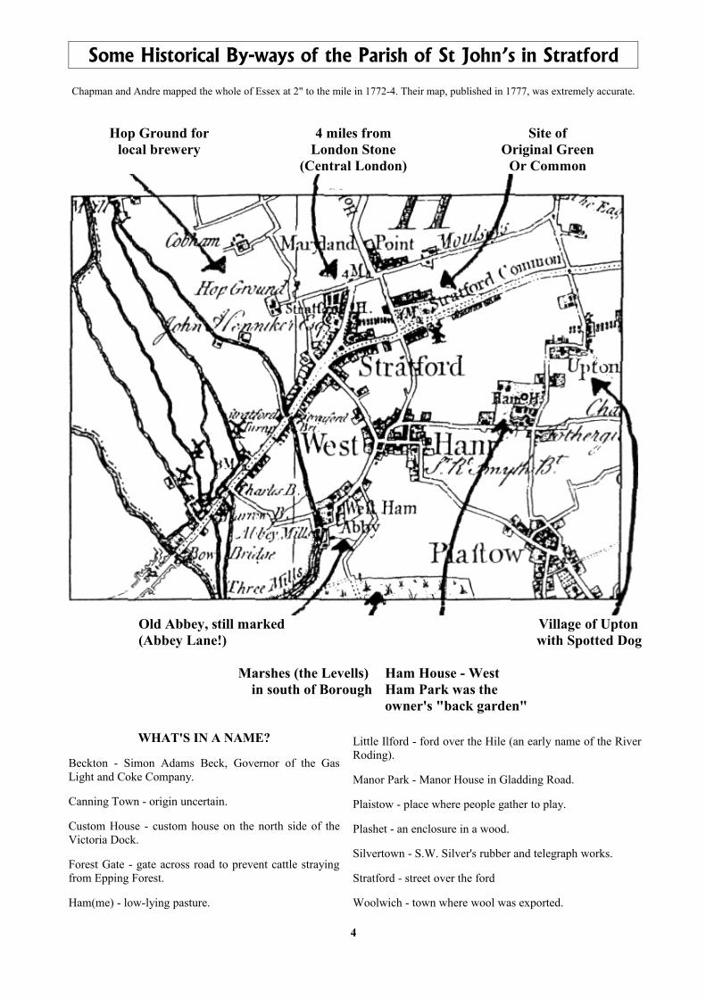
Chapman and Andre mapped the whole of Essex at 2" to the mile in 1772-4. Their map, published in 1777, was extremely accurate.
Hop Ground forlocal brewery
4 miles fromLondon Stone
(Central London)
Site ofOriginal Green
Or Common
Old Abbey, still marked(Abbey Lane!)
Village of Upton with Spotted Dog
Marshes (the Levells) in south of Borough
Ham House - WestHam Park was theowner's "back garden"
WHAT'S IN A NAME?
Beckton - Simon Adams Beck, Governor of the Gas Light and Coke Company.
Canning Town - origin uncertain.
Custom House - custom house on the north side of the Victoria Dock.
Forest Gate - gate across road to prevent cattle straying from Epping Forest.
Ham(me) - low-lying pasture.
Little Ilford - ford over the Hile (an early name of the River Roding).
Manor Park - Manor House in Gladding Road.
Plaistow - place where people gather to play.
Plashet - an enclosure in a wood.
Silvertown - S.W. Silver's rubber and telegraph works.
Stratford - street over the ford
Woolwich - town where wool was exported.
4

Some Historical By-ways of the Parish of St John’s in Stratford
Imports and exports needed new ports; the world's largest docks were constructed on the old swamps of the area, as well as in Tower Hamlets.
Ships sailed from these docks carrying the output of factories (where working conditions were often awful); they returned with raw materials, food and people. By the 1880s West Ham had one of the largest populations in the country, made up of people from virtually every corner of the world.
The railways reached Stratford in 1839 (very early); five years later London forced its smellier industries to move across the Lea into Newham!
Railway Junction, Stratford. 1865
In 1860 the first iron-clad ship HMS Warrior was launched from the Thames Ironworks (the later birthplace of West Ham United football club (look at the badge)).
Building the first British iron-clad battleship H.M.S. 'Warrior' at the Thames Ironworks, Canning Town. 1860.
More people moved in, some to the more gracious houses along Romford Road, many more to the poor conditions of the docks areas of Canning Town and Silvertown.
In 1884 the Theatre Royal opened. 6 years later Keir Hardie, first ever Labour MP, was elected for West Ham South.
The docks area made East Ham and West Ham prime targets for German zeppelins in WW1 and also German bombers in WW2: this was the Blitz during which West Ham was raided 194 times, losing 1207 dead and one third of its houses.
Redevelopment was slow; the famous pre-fabs appeared; in 1953 the River Thames flooded; tower blocks appeared. In 1965 West Ham and East Ham were combined to form the Borough of Newham, part of the traditional East End.
Governments began to recognise their neglect of the areas which had suffered in the Blitz and plans began to redevelop the area. A boost was given when three West Ham players 'helped' England win the 1966 World Cup !
5

Some Historical By-ways of the Parish of St John’s in Stratford
A new Freight Terminal opened on the derelict areas of the vast Railway Engineering Yards in Stratford, a new Rail Station, a new Bus Station, a Euro-Station; new rail routes linked the East End with the City, the new Docklands (and the Dome!); soon, a new “City”
A new set of Municipal Offices (The Pyramid) was built in the Grove in Stratford only to be demolished in 1998; now Safeways.
The old North East London Polytechnic achieved University status.
A new General Hospital was built in Plaistow in 1983. A year later the Thames Barrier opened to prevent a recurrence of the 1953 disaster.
The Gas and Sewage plants in Beckton gave way to a new town along Newham Way near the new City Airport.
The 1960s Mall (which had been built over an authentic East End market street. Angel Lane) in Stratford was itself redeveloped, as was the Theatre Royal, a famous East End venue for many celebrities and home of Joan Littlewood. An Arts complex was designed for the area. On the old rail-lands a huge new “City” is being built. Things are looking up!!
6

Some Historical By-ways of the Parish of St John’s in Stratford
7

Some Historical By-ways of the Parish of St John’s in Stratford
(1) THE START: St John's Church. Stratford (1834) and the Martyr's Memorial for 1556
In St John's churchyard is the late 19th century monument to the 23 local Protestants burnt alive in 1556 during the persecutions under Queen Mary Tudor. Their names are inscribed here. The burnings possibly took place on Stratford Green, once called Gallows Green, (see Site (9))
We leave the churchyard by the northern gate and turn right along the pedestrianised Broadway (surprisingly, this is not Stratford High Street: that lies beyond the (blue) Education Offices in the direction of Bow). We reach the new Town Square (circular in shape!). Opposite stand the new Public Library and Safeways.
(2) The Grove - Edith Kerrison Memorial, St Francis’ Priory and Church (1868), Gerard Manley Hopkins & The Old Music Hall (without canopy)
Outside the new Library is a monument to alder(wo)man Edith Kerrison (1850-1934), the first woman to be elected to West Ham council. A trained nurse, she was influential in the areas of Public Health, Education, Libraries and providing for young men. Next to it stands a memorial to Gerard Manley Hopkins and further on the modern Peace Statue.
Beyond the significantly named Great Eastern Road (Stratford once had huge railway marshalling and engineering yards) we see on the left St Francis' Roman Catholic Priory, dating to the mid-19th century. The Church building (1868) is round the corner in Grove Crescent Road. It has a fine Italian painted altar-piece. (The main road at this point is called the Grove, once site of many fine homes. The poet Gerard Manley Hopkins was born at No 87 Grove in 1844 and spent the later part of his life attached to the Priory)
On the right-hand side of the Grove, next to the Baptist Church, is the newly-refurbished Music Hall-Kinema (sadly, the intricate iron canopy was lost in the rebuilding).
(3) Windmill Lane - Site of Railway Engineering Works, The Railway Tavern & Angel Cottage
As the main road bears right, the road to the left is Windmill Lane: old maps do show windmills here, high up and away from the rivers which have for centuries powered the more famous water mills of the area. Some 50 yards along on the right, now a block of flats, was an engineering works, part of the old British Rail (and before that, G.E.R) Railway Engineering Yards. Here on December 10th 1891 85 men built an entire locomotive in less than 10 hours (still a world record)
Where Windmill Lane meets the mediaeval line of Angel Lane (where the Beatles filmed "Penny Lane", before it was subsumed by the Shopping Mall) stands the significantly named Railway Tavern. (The road signs show two forms of power).
Opposite the Railway Tavern, in its own walled garden, stands the delightful Angel Cottage, dated above the door 1826. At one time this was under threat by the original redevelopment of Stratford Shopping Mall (!!)
8

Some Historical By-ways of the Parish of St John’s in Stratford
(4) Maryland Point – Victorian Shops, Remains of Watney Mann Brewery
Maryland Point takes its name from a 17th century landowner in the area who had interests in the (then) New World. The 'dog-leg' in the road at this point, pre-dating the railway, may mark a tollgate or turnpike.
Following the main road round, passing Maryland Station on your right. The road bears left and northwards. On the curve, look up to the coloured Victorian enamelling on the roof-line of the chemist's shop. Just beyond is a brown wall with arches, all that remains of the old Watney Mann's Brewery. There was always much distilling in the area (given the water-mills), but old maps show this immediate area to be Hop Grounds, hence the brewery on site.
(5) Maryland Point - Stink Pipe
On the road island, by flowerbeds which were once stairs to underground public conveniences, still stands a successfully refurbished Victorian stink-pipe, flushing out bad air from the lavatories below. This road island used to be cattle pens. Look back across the road you have just crossed: the shops on the curve date back some 200 years: note the overly-large chimneystacks.
(6) Maryland Point, Water Lane – Old Presbyterian Church
Beyond the traffic-island, cross by the new tower block, where once stood a Presbyterian Church, and turn right (south) down Water Lane. Originally this road marked the heart of "old" Stratford, (before it moved to its present location) leading past the Green to Vicarage Lane and the ancient church of All Saints.
(7) Water Lane – Manbey Estate, old Butchers Shop, Deaf School, St Stephens & Stratford Artillery Barracks
On the corner of Manbey Park Road notice an elegant double-fronted house, set high up, and next door an ornate one-storey Victorian shop. (The Manbeys were a rich family who once owned extensive land in this area: when it was sold off and split up in the 19th century the name remained in the streets and the public house, the Manbey Arms).
The road continues south and bends slightly by a block of flats and Sarah Bonnell Girls' School. Note in the wall a blocked-up doorway marked "Boys' Entrance" (an oddity explained by two further signs, much higher up, marking this as the old Board Deaf School).
(8) Water Lane - Victorian Public Library (1898) & Willaim Shakespeare
As Water Lane approaches the Romford Road note on the left a fine collection of late Victorian municipal buildings, once a College and Public Library, now part of the campus of the University of East London. (Note the perplexed statue of William Shakespeare: is he in the wrong Stratford ?)
(9) Water Lane, Romford Road - Stone marker of 'Stratford Green and Common'
At the very corner of the junction, look through the iron fence to a great stone block with a brass plaque marking this as Stratford Common and Green (also known as Gallow's Green, this marks the possible site of the burning of some of the Stratford Martyrs (see (1))
9

Some Historical By-ways of the Parish of St John’s in Stratford
(10) Romford Road, Vicarge Lane - Old Electricity Board offices (1927)
Facing the UEL campus, note the imposing Electricity Board building, now a block of flats, mainly from 1927-1930. In the 1930s vans from this office were powered by electric battery !!
(11) Vicarage Lane – Cobbled Lane
Cross over Romford Road and go down the road opposite. This is Vicarage Lane, leading from Stratford village to the old church, which was some way away. Some 200 yards down, on the left by a low block of flats, notice an old cobbled lane. Until recently, about 20 yards along this old lane, there was a fine granite mark-stone, placed either to facilitate horse-mounting or to prevent damage to wagon-wheels.
(12) Whalebone Lane
Cross Vicarage Lane and enter the very old pedestrian walkway named Whalebone Lane (the shops at the other end in West Ham Lane are called Whalebone Terrace). The name is obscure: whalebones were once used in making women’s corsets. At this end of Whalebone Lane were once cottages dating back to 1707, or so it was said: they were called Union Cottages. There were also six cannon set in the ground as barriers: as children we were told they came from Trafalgar (some still remain further along the lane).
(13) Bryant Street, Kay Street – Methodist Church, Queen Mary’s Hospital, John Curwen
Cross West Ham Lane and turn left down Bryant Street. Halfway down note an old arch built between two new blocks. This, as an inscription records, is all that remains of Queen Mary's Hospital for the East End, bought and paid for by local (poor) subscriptions.
Enter the paved lane by the courthouse, opposite the end of Bryant Street. Until recently there was a small one-storey Chapel here: as a child I was told this was one of the sites used by Congregational minister John Curwen (1816-1860), promoter of the Tonic Sol-Fa musical notation system (though most of his work was done in Plaistow and Earlham Road, Forest Gate).
Follow the lane round to Bridge Street. On the corner of Bridge Street and the High Street, see
(14) High Street - The old Borough Theatre (1896), Stratford Market Station (1896)
The old Borough Theatre, opened in 1896, with its associated buildings, still elegant above first-floor level. It later became the Rex Cinema, and in recent times became a music venue.
Immediately to your left (westwards). The tiny station of Stratford Market once sat astride the branch line from Stratford Main to the old food market.
(15) Burford Road – Old Market Hall
The market buildings still stand, down Burford Road, it had its own public house, the Burford Arms, which used to run 'market hours'.
10

Some Historical By-ways of the Parish of St John’s in Stratford
(16) Channelsea River
Walk along canal pathway. On right hand side are old walls of original canal, with mooring rings for barges/narrowboats.
(17) Abbey Lane – West Ham Abbey, Victorian Cottages
At end of path, turn right and emerge onto Abbey Lane (named after mediaeval monastery once in this area), ahead are Victorian cottages built at time of construction of Bazalgette's sewage pumping station, turn left and cross to Greenway ahead.
(18) The Greenway – Sir John Bazalgette
Ascend stone steps to Greenway. You are standing on a 150 year old Sewer, carrying London's waste to Beckton: built by Bazalgette, an unsung London hero. See Bazalgette's sewage pumping station on right.
(19) Channelsea River flats
See Channelsea River flats: this is tidal (note direction of flow of waters) (and dangerous). Follow tarmac & gravel path opposite (heading south).
(20) Prescott Channel – Listed Gas Holders, Euston Station
Keep River to left, follow path. Nature area. See listed Gas-Holders ahead. Cross Prescott Channel by metal bridge. Remains of old Euston Station Memorial Arch used to plug hole in bottom of river here.
(21) Three Mills
Follow river path to left and long painted wall, by southern Bound of parish. Turn corner and see panorama of Three Mills tidal complex. These mills go back a thousand years. Largest two-way tidal watermills in Britain, taking advantage of tides in Thames (not far away)
(22) Clock Mill
Emerge in paved courtyard by Clock Mill. Left a footbridge to Poplar (and Tesco's) (superb lock-gates)
(23) River Lea
Cross footbridge then immediately right and down ramp. Walk along towpath until BOC depot.
(24) Bow Bridge
See ahead, along river, site of original Bow Bridge. Turn left then right (north) at top heading towards Bow flyover.
11

Some Historical By-ways of the Parish of St John’s in Stratford
(25) Bow Flyover – King Alfred
Cross the High Street under Flyover (with very great care) and descend slope to (canalised) River Lea/Lee. The many waterways in this area are held to have been first controlled by King Alfred the Great as part of his campaigns against the Vikings (800s).
(26) Bow Back River
Immediately to your right is Bow Back River, another part of the old industrial transport infrastructure. Moorings for narrowboats.
(27) River Lea – Northern Outfall Sewer
Walk north. Actual Bounds off to right crossing through factories and fields. Pass under Railway Bridge and Northern Outfall Sewer Bridge. Note wildlife: swans, moorhens, bulrushes, terrapins
(28) Old Ford Lock – Lea Navigation
Reach Old Ford lock. (Near here the old Roman road out of Londinium crossed the Lea). Canal splits. Cross footbridge to view the (still-working) double locks and lock-gates on the River Lee Navigation (old word for canal). (Be very careful). Back over bridge and head north-east (left).
(29) Pudding Mill River
The river Lea at this point marks the western bound of the parish. Cross old Pudding Mill River on flying hump bridge.
(30) City Mill River – Olympic Stadium
Cross City Mill River on flying hump bridge. Turn right up stairs to road. (The parish Bound continue along the River Lea for some considerable distance further, then doubles back almost to Carpenters Road). See across bridge and to right of river proposed site for Olympic Stadium.
(31) Carpenters Road – Channel Tunnel Rail Link
Turn left and then right into Carpenters Road. (Be very careful along here. Traffic is fast and there are/were many derelict vehicles blocking the footpaths). See off to left massive spill mound from Channel Tunnel Rail Link excavations.
(32) Carpenters Estate – Worshipful Company Of Carpenters
Pass under railway bridge and emerge into "our" Carpenters Road. The parish Bound turns along the far side of the Carpenters estate by the present railway line following line of old Channelsea River. There is footbridge to the Bus station; we go ahead to High Street.
12

Some Historical By-ways of the Parish of St John’s in Stratford
(33) High Street – Meridian Plate
Turn east (left) along the High Street, heading towards Stratford. Cross railway line opposite Stratford Market Station. See Meridian marker plate on bridge.
(34) High Street – Railway Sculpture (or not)
This elegant piece of modern sculpture symbolises the huge railway engineering yards which once occupied the enormous spaces to the north of the present-day Stratford Station (see the new Bus and Rail Stations along the road to your left). The sculpture, set in a compass, is formed as curved rail-tracks.
(35) Great Eastern Road – Stratford Station, Meridian Square & Clock, Thomas & Original Station Buildings
Turn into and through bus station to Meridian Square. See Meridian Clock, Railway Engine, Old Station Entrance, Original Station Building visible across railway line
(36) Theatre Square – Theatre Royal
Follow Great Eastern Road left to lights at Angel Lane, cross to Theatre Square, See Theatre Royal et al.
(37) Stratford Mall - Angel Lane Market
Turn right around side of theatre to Mall, Old Angel Lane Market, then south to central area and east to Broadway (entrance to Mall was south end of Angel Lane)
(38) Broadway – Gurney Memorial (1861), Tramway Avenue, King Edward VII (1765, c1830, 1914)
This obelisk was erected in 1861 to commemorate local worthy, the Quaker Samuel Gurney. (It served as a terminus for trams and carriages) Opposite, to the south, there is a short stretch of road named Tramway Avenue (there used to be tram sheds a short distance down on the left, near the old Gaumont Cinema, reputed at one time to be the largest in Europe).
Facing the south side of St John's Church stands the conspicuously low structure of the Edward VII public house. There was an inn here named the King of Prussia as early as 1765, being named after Frederick the Great (Elizabeth Fry, local prison reformer, met another King of Prussia in Stratford in 1842). For obvious reasons, the name became an embarrassment in 1914, whereupon it was renamed after the late King.
(39) The Church of St John The Evangelist, Stratford
Carefully re-enter the Churchyard, either from the Mall side, crossing the pedestrianised bus-way, or from the public house above (38), crossing the wide and dangerous Romford Road (note the "Rom" prefix, for “Roman”; deep down is a via, the Latin/Roman word for “road”).
13

Some Historical By-ways of the Parish of St John’s in Stratford
Stratford Railway Works achieved a still-unbeaten world record with this G.E.R. locomotive, No.930. This was the fastest-built locomotive ever, constructed in only 9 hours 47 minutes by a team of 85 men on 10-11 December 1891. No.930 gave over 40 years of service, running for more than a million miles before being scrapped in 1935.
14

Some Historical By-ways of the Parish of St John’s in Stratford
15

Some Historical By-ways of the Parish of St John’s in Stratford
A BRIEF HISTORY OF ST. JOHN'S CHURCH. STRATFORD. LONDON E15
St. John's Parish was originally part of the ancient Parish of West Ham. In 1832 the Vicar of West Ham (who was also the Archdeacon) saw that Stratford was growing, and he said there was an urgent need for a Church at the centre of Stratford. Much of the money to build the new Church was given by local people, and the Church was built in 1834.
St. John's was designed by Edward Blore who was one of the leading architects of his day. Blore was given the job of finishing off Buckingham Palace after Nash, a famous architect, was sacked for being too extravagant. St. John's was designed in the Early English style with a tall, ornate south western spire. Interesting architectural features are, externally, the lancets (like stone bridges) and internally the moulded piers (grooves in the pillars) and depressed arches (the tops of the arches are flatter than usual).
Originally there was a gallery at the back of the Church, and plans show an organ on the gallery. Building work in the mid 1990s revealed the bricked-up door leading from the tower on to the gallery.
A famous name connected with St. John's is the poet, Gerard Manley Hopkins. He was born in 1844 at 87 The Grove, Stratford, which was just opposite the Church. Gerard's family had contributed towards the building fund for the new Church. Gerard was baptised at St. John's in August 1844. Gerard later became a Roman Catholic. There is a memorial to him in Poets' Corner in Westminster Abbey.
In 1879, during the incumbency of the Rev W J Bolton, the Martyrs Memorial was built in St. John's Churchyard to commemorate the men and women who were burnt at the stake in Stratford in 1556 during the reign of Mary Tudor.
In 1884 the interior of the Church was completely changed. It seems likely that the gallery was removed at this time. The Church was extended with the building of the Chancel, the Choir Vestry and the Organ Chamber. There is a plaque near the organ stating that the Chancel is in memory of Sir Antonio Brady, a famous geologist of the time. His collection of prehistoric animals is now part of the national collection at the British Museum. Sir Antonio Brady died suddenly in 1881 at the family home in Forest Lane, and was buried in St. John's Churchyard.
16

Some Historical By-ways of the Parish of St John’s in Stratford
In 1889 the Rev Thomas Stevens became Vicar of St. John's. He became Archdeacon of Essex in 1895 while continuing as Vicar of St. John's. Then he left in 1901 to become the first Bishop of Barking.
During the 1939-45 war, many hundreds of people took shelter night after night in the crypt of St. John's. The Church was badly damaged by bombing: in particular all the windows were blown out. The only pre-war window is the small window in the Chancel which is a copy of the famous picture by Holman Hunt "The light of the World". This was taken out and stored before the bombing. The Churchyard railings were removed for the war effort. The Friends of St. John's was formed in 1944 to keep members who had been bombed out of the East End in touch with each other. The Friends contributed towards the cost of repairs and the Church was fully restored from war damage in 1951.
After the War St. John's went in to a bit of a decline. Many of the faithful members had been bombed out, others moved out as a result of demolition and new developments. By the 1970s the congregation was quite small, the building was in poor structural condition, the doors were locked except for Sundays and there was even talk of closure.
In recent years congregations have increased. The average attendance is now 300 adults and children on a Sunday morning, and 55 adults in the evening. The congregation is very multi-cultural, reflecting the community around us. The Church is also open every day with midweek services for people who work in Stratford during the week. The nature of ministry at St. John's has changed greatly over the past few years. A new extension was built in 1998 to provide facilities for the local community and the building is a hive of activity once again - a place for prayer, for meetings, for concerts, for peace and quiet in a busy town centre.
In 1834 St. John's was built to serve the Stratford community. 170 years later that community has changed again and again. St. John's has changed too - the building has been extended twice, the pattern of Church Services has also changed. However, the basic reason for St. John's existence has not changed. St. John's is part of the worldwide Christian Church, dedicated to spreading the good news that Jesus Christ came to earth 2000 years ago, that he died for our sins on a cross, that he rose again from death to life and that he lives for ever and still has the power to change lives.
St. John's is a living witness to that message.
David Richards, Vicar of St. John's
17

Some Historical By-ways of the Parish of St John’s in Stratford
Stratford over a century ago: can YOU find your road ?
If you want to know more about your Borough, then (1) you can join the Newham History Society (contacts at either East Ham or Stratford Public Library), or (2) read the many excellent Local History books (see W.H. Smith), such as the recent huge picture history of "The East End", S. Pewsey "Stratford: A Pictorial History", or the works of the late H. Bloch. (Most of the illustrations in this booklet come from these)
18