SOMAARTH DDESS OPERATIONAL MANUALsomaarth.org/wp-content/uploads/2018/07/SOMAARTH... · A...
49
Page 1 of 49 SOMAARTH DDESS OPERATIONAL MANUAL The INCLEN Trust International F1/5, 2nd Floor, Okhla Industrial Area Phase-I, New Delhi- 110020
Transcript of SOMAARTH DDESS OPERATIONAL MANUALsomaarth.org/wp-content/uploads/2018/07/SOMAARTH... · A...

Page 1 of 49
SOMAARTH DDESS
OPERATIONAL MANUAL
The INCLEN Trust International F1/5, 2nd Floor,
Okhla Industrial Area Phase-I, New Delhi- 110020
Page 2 of 49
Contents Purpose of the Operational Manual .................................................................................. 3
Preface ................................................................................................................................ 4
Chapter 1: Introduction ...................................................................................................... 5
Chapter 2: Initial Work-up while establishing the DDESS ................................................. 8
Chapter 3: DDESS: Key Definitions ................................................................................... 10
Chapter 4: Demographic surveillance processes ........................................................ 16
Chapter 5: Development and Environmental Surveillance using GIS .......................... 30
Chapter 6: Data Management ........................................................................................ 40
Chapter 7: Ethics Considerations .................................................................................... 47
Chapter 8: SOMAARTH DDESS Administration ................................................................. 48

Page 3 of 49
Purpose of the Operational Manual
This operational manual is intended for use by two audiences:
those who plan to establish a demographic, development and environmental
surveillance site (DDESS), and
those who have already established a functioning site and are now looking forward to
introduce new themes in their surveillance system.

Page 4 of 49
Preface Following a MOU with the Government of Haryana, SOMAARTH-DDESS Palwal was
established by The INCLEN Trust International in 2009 to undertake community-based studies
on health and allied disciplines. Adopting a catalytic health system strengthening approach,
INCLEN is closely engaged with the community of 51 contiguous villages (SOMAARTH
villages) in Palwal, Hathin and Hodal blocks of Palwal District. The DDESS encompasses
about 200000 individuals from different religion and diverse socio-economic background. The
area is geo-spatially coded and an updated census is maintained for surveillance using latest
research and IT tools.
The SOMAARTH Palwal experience is being leveraged to establish two other DDESS:
SOMAARTH-Barielly (Uttar Pradesh) and SOMAARTH-Shillong (Meghalaya). This manual
will be a useful resource for establishing and facilitating operations at the SOMAARTH sites.
The manual covers following aspects:
1. Background for developing a community site.
2. Stepwise processes in developing the site
3. Detailed operational methodology following the establishment of site
4. Benefits and challenges in establishment of the community site

Page 5 of 49
Chapter 1: Introduction
SOMAARTH
“SOMAARTH” is derived from two Sanskrit words: “Som” means highest form of
physical, mental, and spiritual health. “Arth” means money, wealth and resources.
SOMAARTH ideology, envisions synergy between economic development, social
changes and health of the individuals, families and communities.
The SOMAARTH Demographic, Development and Environmental Surveillance Sites (DDESS)
have the following aims:
Establish an integrated surveillance system that is simple, feasible, affordable and sustainable,
addressing health in the context of environment.
In the background of “Whole of Society” transition, determine the interplay between
economic environment, agriculture, markets, urbanization, town planning, built environment,
education, globalization and socio cultural factors that influences population behavior and its
impact on biology , nutrition, physical and psychological health of individuals, families and
communities.
Provide a platform for multi-disciplinary, policy and program relevant studies with multi-
sectoral collaboration the same geographic area.
Establish an Integrated Management Information Systems (IMIS) to facilitate the collection,
analysis, reporting, presentation, and use of data at local, district, regional, and national levels
for the overall aim of bringing convergence between development and health.
Develop pragmatic models of synergistic development with defined health outcomes in
collaboration with communities and scaling up to other areas.
Explore innovative models of Public-Private Partnership for surveillance mechanism and
primary health care service delivery.
Evolve SOMAARTH in to a platform of multi-disciplinary learning and capacity building for
next generation of health and non-health academic leadership.

Page 6 of 49
SOMAARTH has the following surveillance components:
Demographic Surveillance: It encompasses periodic documentation of the size, structure and
distribution of populations in the area, and spatial and/or temporal changes in them in response to
basic demographic events (birth, migrationand death).
Development and built environment surveillance: It covers documentation of spatio- temporal changes
in land use (including commercial, industrial, institutional, educational, transportation) and contextual
structures.
Environmental Surveillance: It includes surveillance of the indoor and outdoor air quality, ambient
metereological data i.e. temperature, humidity and wind direction as well as water and sanitation.
Surveillance of community health: SOMAARTH sites have the objective of strengthening the public
health system and related community processes through community engagement, needs assessment,
epidemiological data collection and close partnership with the Government health system.

Page 7 of 49
Box 1.1: Geo-demographic details of SOMAARTH DDESS- Palwal Palwal, Haryana (India): Haryana is a relatively prosperous state
in North India surrounding Delhi NCR.. Palwal is a newly created
district of Haryana neighboring Faridabad and Mewat districts.
The district headquarters, Palwal town, lies 30 km beyond
Faridabad on the Faridabad-Agra national highway. When created,
the district had four blocks-Palwal, Hodal, Hathin and Hassanpur
with 282 villages and area of 1,359 sq.km. Total population of
Palwal is 1,042,708 (decadal growth: 25.8%; 554,497 males,
488,211 females). Sex Ratio of Palwal District is now 880 while
child sex ratio (0-6) is 874. Density of Palwal District per square
km is 767 (2001: 606 per sq.km). Average Literacy rate for Palwal
District is 69.32 percent. The districts has primarily an agriculture
driven economy but is experiencing rapid industrialization and
urbanization.
SOMAARTH DDESS (Latitude: 27°53'59.46"N to 28°7'30.02"N; Longitude:
77°10'2.95"E to 77°22'47.35"E): With an area of 251.7 Km Sq, it encompasses 51 contiguous villages (1,99,702
rural population) from three blocks of Palwal (Hathin, Hodal and Palwal) that are circumscribed by three major
roads i.e. – Mathura national highway (NH2) that forms the sites’s eastern boundary; Palwal–Hathin state major
district road (MDR 135), forming the western boundary; and connecting major district road (MDR132) between
Hodal and Nuh forming the southern boundary. This site has a demographic advantage of having a mix of
populations from different religions, socioeconomic and overall development status. This site has been selected
based on assumptions of rapid economic transition and emergence of business and educational activities that
will lead to changes in behavior and health of the individuals and the population at large. A peripheral express
highway (Kundli-Manesar-Palwal or KMP expressway or western peripheral expressway) is fast coming up and
which traverses through some part of the site. Additionally, special economic zones (SEZs) are declared on
either side of the proposed expressway to boost industrial growth and business. Along NH2, one of the busiest
roads in the country, several major industries, educational institutions and hospitality businesses have come up
over the last three to five years. The real estate has gone up by more than five folds in anticipation of the growth
potential of the area.
On the basis of developmental attributes and access to the highway we have divided the surveillance area,
broadly into three regions:
(1) Villages within 4 kms of the proposed KMP Highway (n-15): The eastern and western peripheral
expressways (Kundali Manesar Palwal [KMP] and Kundali Ghaziabad Palwal [KGP]) shall traverse the
region; and several SEZs with new manufacturing and service industries are likely to be established in
the area.
(2) Villages on existing NH-2 Delhi-Agra Highway (n-12): Villages within one km of Agra highway are
experiencing change over a considerable period of time. Several land stretches are declared as
educational, commercial and industrial lands wherein several institutions and business establishments
have already come up, in addition to private technical and management institutions;
(3) Villages relatively far from these two highways (n-24): The south-west part of surveillance site belongs
to the previous Mewat region, one of the most backward area in the North India and predominantly
populated by Muslims. This area is challenged with low literacy, economic status, health indices, and
other development indices.

Page 8 of 49
Chapter 2: Initial Work-up while establishing the DDESS
Knowing the area:
o Preparatory work: Conducting background study i.e. understanding the area and
resources using census of India, National Health Family Survey, District Level Health
Survey, Annual Health Survey, administrative documents etc.), identifying potential
stakeholder constituencies. An internal communication brief should be written and shared
with all the team members in order to have consistency in the content of the dialogue. Based
on the secondary data (district statistical handbook, Bhuwan etc) potential periphery
demarcation should be done. Budget and timeline should be planned.
Community engagement
o Community engagement is one of the most important and continuous process. For each of
the sub activity tools and techniques need to be prepared beforehand.
o Area visit
Keeping background information of the area, about the organization, one pager on
the proposed plan and internal communication brief.
Identification and interaction with key stakeholders (local administration i.e.
district – block level, Panchayati Raj Institution (PRI) members, other agencies
having community presence)
Assess political, social, economic and religious environment
Transect walk in the villages and informal interaction with the community.
o Interaction with community
Meeting with village leaders and community members.
Group discussion and one to one semi-structured interactions with the community
leaders.
o Desk work
Summarized report about the visit with inputs from all the members of field visit
team and getting feedback.
Mapping of agencies’ presence in the geographical area and based on the inputs
gained during the field visit, refinement of the surveillance site periphery.
Administrative procedure
o Permissions: Seek administrative approvals from competent authority to work in a
particular area (Drafting of MoUs, taking permissions etc.)
Setting up field office:
o Identification of location: Field office should have good access and a neutral location i.e.
should not have influence of any political, religious or administrative parties or person. The

Page 9 of 49
location of the office should be such where anybody /or everybody from all the surveillance
villages can visit with ease.
o Logistics and infrastructure arrangement: Office setup should match the local area SES
attributes.
o Staff recruitment: Preparation of a manpower requisition document highlighting number of
staff required, qualification / experience and job responsibilities and timeline to have them
on board. Team should be planned as per the project need. The core surveillance team could
have following members- Project PI/ site in charge, station manager, research officer
census, research officer- GIS, GIS analysts, community coordinator, field workers.
Development of manuals
o Preparation/ refinement of operational manual
o Preparation of training manual (procedural manual)
Development of data management infrastructure
o Design, pilot testing and finalization of project specific data collection tools
o Design, pilot testing and finalization of electronic software, equipment, forms and
processes
o Understanding the harmonization of surveillance data and project specific data collected
from the field.

Page 10 of 49
Chapter 3: DDESS: Key Definitions
SOMARRTH DDESS is a comprehensive surveillance platform as it includes three domains of
surveillance i.e. – Demographic, Development and Environmental surveillance. The focus of
demographic surveillance is individual and households; development surveillance focuses on the land
use and land cover; environmental surveillance focuses on monitoring of physical environment
including weather conditions within the surveillance site. SOMAARTH DDESS design, core concepts
and definition pertaining these three main focus areas are described in this chapter.
Every demographic surveillance system is required to define the population under surveillance. As most
individuals within any population have places of residence and attachments to social groups, the task
of defining the population begins with the identification of the land parcel, households (where
applicable), and individuals that will be visited and observed and assigning them unique codified
identifier numbers that can be tracked and followed-up for identifying temporal changes [Box 3].
Box 3.1: SOMAARTH Key Definitions
Land Parcel A piece of land including all physical structures built on it (if any), has at least one
owner and is being used as residential/non-residential or lying vacant or has
ruins/under construction is called land parcel. A land parcel has clear boundary and
has its own shape and size. In rural areas a land parcel may not always have a
demarcated compound wall or fencing. Sometimes boundary can also be demarcated
by hedges or planting. This piece of land is not available for agricultural use.
Types of Land Parcel
Residential land parcel: A land parcel which is exclusively used for residential
purpose. Residential land parcel should have a physical structure or building
which has been occupied for residential purposes.
Non-residential land parcel: A land parcel which is exclusively used for non-
residential purposes. Non-residential land parcel should have at least one structure
or building which has been used for non-residential purpose. Example: for shops,
cattle sheds, baithak, pump house, clinic, etc.
Mixed Land Parcels: Land parcel having both residential and non-residential
activities. A mixed land parcel is comprised of minimum one residential and one
non-residential unit which may be on same or different floors. Mixed land parcels
are very common in rural areas and they should also have at least one building or
physical structure within its boundary.
Vacant land parcel: A vacant plot without any structure built on it. It may or
may not have a demarcated boundary in rural areas of India.
Physical
Structures
A physical structure (of any shape and size) built within the territory of any land parcel
which usually has four walls and a roof. There can be one or more physical structures
on a single land parcel.
On the basis of construction materials used, physical structures are classified in
following three categories:
1. Pukka: A pukka structure is defined according to the composition of their wall
and roof. The wall materials should include bricks, cement bricks, concrete, stones

Page 11 of 49
and GI/Metals /asbestos sheets. The roof materials should be concrete, machine
made tiles, burnt bricks, cement bricks, stones, slate, GI/Metals /asbestos sheets.
2. Kuchcha: A kuchcha structure with walls and /or roof which is predominantly
made of materials other than those mentioned in pukka structure. The wall
materials should include unburnt bricks, bamboos, mud, grass, reeds, thatch, and
plastic, polythene, loosely packed stones. The roof materials should be unburnt
bricks, bamboos, grass, reeds, thatch, plastic, polythene.
3. Mixed: When either wall or roof of a structure is made of Kuchcha or Pukka
materials as mentioned above.
Unit On the basis of activities, physical structures are divided into residential unit or non
residential unit. Physical structure used for residential purpose is known as
‘Residential unit’ or household and structure used for non-residential purpose is
known as ‘Non-residential unit’.
Residential
unit or
Household
A group of individuals who live together under the same roof and share the common
kitchen is termed as Household.
1. Individuals from a household may or may not be related (neither blood
relations nor conjugal relations).
2. Number of individuals who belong to a particular household may vary from
single individual to multiple.
3. Following exceptional situations will also be considered as households:
- Related / Unrelated individual(s) living under the same roof but
getting food from outside.
They may or may not have a kitchen in the dwelling unit. Household are also known
as residential units.
Type of
Household
1. Normal household: A group of persons (related/unrelated/mix) living together
under same roof of typical land parcel and sharing common kitchen.
2. Institutional household: A group of individuals (related/unrelated persons)
who live in an institutional buildings and take meals from a common kitchen
is called Institutional household, Considerations:
a. Paying guest accommodation: group of people(mostly unrelated)
living together under same roof and taking food from a common
kitchen. Such units are registered under institutional household
category.
**hostels are guest houses are considered under non-residential
categories.
Homeless household: Households which don’t live under the roof, but on roadside,
under flyover/pipes/staircases/platform/bus stop are termed as homeless household
and these are not currently registered under SOMAARTH DDESS.
Non
residential
unit
A physical structure used for non residential activity are called non residential units.
Based on the main activity non residential units are divided into 10 broad categories.
Eligible
Individual
Eligibility criteria provided in chapter 3.
Note: Household is a group concept which is accounted on individuals and how they are living. Household staying for at least 6 month in a village under SOMAARTH DDESS will only be considered eligible for registration.
Page 12 of 49
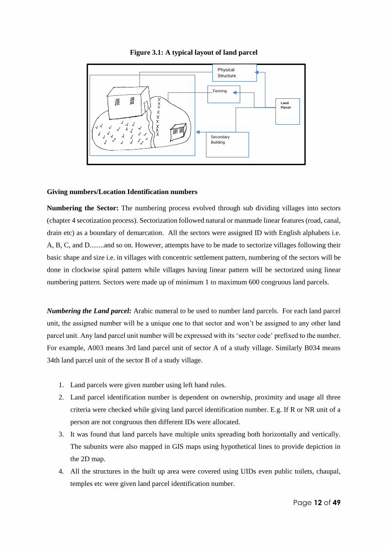
Figure 3.1: A typical layout of land parcel
Giving numbers/Location Identification numbers
Numbering the Sector: The numbering process evolved through sub dividing villages into sectors
(chapter 4 secotization process). Sectorization followed natural or manmade linear features (road, canal,
drain etc) as a boundary of demarcation. All the sectors were assigned ID with English alphabets i.e.
A, B, C, and D........and so on. However, attempts have to be made to sectorize villages following their
basic shape and size i.e. in villages with concentric settlement pattern, numbering of the sectors will be
done in clockwise spiral pattern while villages having linear pattern will be sectorized using linear
numbering pattern. Sectors were made up of minimum 1 to maximum 600 congruous land parcels.
Numbering the Land parcel: Arabic numeral to be used to number land parcels. For each land parcel
unit, the assigned number will be a unique one to that sector and won’t be assigned to any other land
parcel unit. Any land parcel unit number will be expressed with its ‘sector code’ prefixed to the number.
For example, A003 means 3rd land parcel unit of sector A of a study village. Similarly B034 means
34th land parcel unit of the sector B of a study village.
1. Land parcels were given number using left hand rules.
2. Land parcel identification number is dependent on ownership, proximity and usage all three
criteria were checked while giving land parcel identification number. E.g. If R or NR unit of a
person are not congruous then different IDs were allocated.
3. It was found that land parcels have multiple units spreading both horizontally and vertically.
The subunits were also mapped in GIS maps using hypothetical lines to provide depiction in
the 2D map.
4. All the structures in the built up area were covered using UIDs even public toilets, chaupal,
temples etc were given land parcel identification number.
Fencing
Physical
Structure
Secondary
Building
Land
Parcel

Page 13 of 49
5. Land marks, vacant spaces, canal, wells, roads and other environmental datasets were stored
separately in spatial database.
6. Shops were given separate UIDs but if the shop is operating in very temporary manner without
any specific infrastructure they were given sub unit identification number.
7. Destroyed structures, ruins and land parcel under construction were given numbers.
Numbering the split or merger: Splitting and merging of units in land parcel happens during the update
round when two or more units (residential or non residential) become one unit (merging) or one unit
(residential or non residential) splits into two or more units (splitting). However, the splitting and
merging of units happen over time/years and hence will not be captured during baseline survey. These
scenarios will occur during update survey in the surveillance site. Split/merger number will be “00” in
the baseline survey and will be automatically updated in the database.
Numbering the unit: All the residential or non residential activities taking place within a land parcel
will be caprured through the residential and non residential forms. Each unique activity covered is called
unit. Units within a land parcel will also be numbered with Arabic numerals but with two digits i.e. 01,
02, 03…..99 (this is simply because, units at maximum, though theoretically have 99 structures). In
standalone (not in household enumeration form) unit number will be expressed in “()” that will be
prefixed by Land Parcel ID where it resides. For example household No A 003/ 1 means, in sector A,
3rd land parcel and 1st structure (R/NR) in that land parcel.
Other points considered while a Location ID is allotted to the Land parcel:
a. For each household, the assigned number will be a unique one to that sector and won’t be
assigned to any other household of that sector of study village.
b. Structures, that are owned by a household but not situated within the same premise, or
separated by road/public places (e.g.- Baithak, temple, another house), must be treated as
separate land parcel (s) and must be given separate land parcel ID
c. Units IDs (prefixed by Land Parcel IDs) will be allotted to sub units.
d. If a new house is constructed after accomplishment of numbering of all land parcels and in
a village, the new construction will be numbered with a new numeral which must be in
continuum with the last land parcel of the respective sector, even if it is
geographically/physically located far off in that sector and not in sequencing . Suppose last
land parcel number of a village is A 045. Now a new construction has come up between
land parcel number A015 and land parcel number A016. This shall be numbered as land
parcel A046.

Page 14 of 49
e. In case of multistoried structure with multiple R/NR units, different floors shall be
considered as different units if they fulfill the criteria to be called as units. In this case
noconsideration for their gates will be given to call them as a seprate land parcel.
irrespective of their gates. These shall be numbered with a “/” prefixed by land parcel IDs
SOMAARTH surveillance site is experiencing rapid structural and economic development. Thus, for
next few years there will be construction of new structures as well as demolition of structures. To
introduce dynamicity to the whole numbering process, following protocol has been adopted.
1. The land parcel unit numbering will be done as follows:
Sector Land Parcel No. Split/ Merger R / NR Unit
Unique Identity of individuals:
Unique identifiers to every individual members residing in SOMAARTH DDESS is established by
linking the subjects in a land parcel unit through a hierarchical system of unique numbers. These are
built up from a unique number for the parcel unit, followed by serial numbers for each of the households
within it (where the notion of households applies) and then for each of the enumerated individuals
within each household. The unique ID for land parcels unit is in turn generated from a composite
number assigned to Block, village, sector and the land parcel unit number.
In this system, the unique number for each individual in the DDESS is a composite of the numbers for
the block, village, sector, land parcel unit, and household member. This involves creating complex
hierarchies, in which the unique number of the residential unit itself is a composite reflecting allocation
to regions, areas, and villages (where they exist). These IDs are unique for individuals. As individual
moves from one land parcel unit to another the individual Id gets change. Thus an individual in his
lifetime may have several IDs as he moves from one dwelling unit to other but these are only unique to
him/her. In the data system multiple IDs in different time period depict the spatial movement of the
individual.

Page 15 of 49
Box 3.2:Household scenarios in rural areas
One hearth in multiple structures within a
land parcel.
They will be enumerated as single
household (as they share kitchen)
Two hearth in multiple structures within a
land parcel.
There may be separate physical structures
with separate kitchen. Two groups staying
in two separate structures but under the
same land parcel: In this case one land
parcel and 2 households will be considered.
They will be considered as two separate
households within a land parcel and will be
given separate enumeration id’s under a
common land parcel id.
Separate hearth in two separate floors
- There may be double storied / multi
storied physical structures with multiple
kitchen
- If separate group of people are staying on
separate floors (residential units) with
separate kitchen , it will be considered as
separate households and different
household id’s will be given to all
households under common land parcel
id. Figure 3.7: One house with two hearth separated by a partition
- Two households living under same
continuous roof, but they cook separately
for their respective families.
These households will be considered two
different households.
- If a structure gets partition in-between
and have two different entrances it will
be considered for two different land
parcels.

Page 16 of 49
Chapter 4: Demographic surveillance processes
Defining SOMAARTH Surveillance System
SOMAARTH surveillance system is defined as a set of field and computing operations to handle the
longitudinal follow-up of well-defined entities or primary subjects (Demography: individuals,
households, family, development: non residential land use, Environmental: physical environment
(covering residential, non residential and vacant land parcels) and weather conditions) and all related
demographic and health outcomes within a clearly circumscribed geographic area (51 villages of Palwal
district). Unlike a cohort study, a DDSS follows up the entire population of such a geographic area.
An initial mapping (with geo-referencing) and census will define and registers the target population.
Regular subsequent rounds of data collection at prescribed intervals will make it possible to register all
new individuals, households, and land parcel changes and to update key variables and attributes of
existing subjects. This will form the core system for SOMAARTH DDESS.
Thus, core system shall provide monitoring of population dynamics through routine collection and
processing of information on births, deaths, marriage and migrations, change in the land ownership,
change in the head of the households— the only demographic events leading to any change in the initial
size of the resident population. This core system shall be complemented by various other data sets that
provide important social and economic correlates of population and health dynamics. In addition to
this a routine (in every two years) update of Geo referred attributes for physical environment (including
built environment) will be done under this core system through wave based data collection activity.
At SOMAARTH, direct method (first-hand enumeration, verification and measurement; survey/
census approach) for data collection is observed. It is divided into two broad categories:
1. Core Baseline Round
2. Update Rounds
This chapter discusses the standard practices followed during data collection.
Baseline round
Purpose: Listing and mapping activity; the initial (baseline) census enumeration.
The initial census focuses on obtaining information across three broad domains in align with the
SOMAARTH philosophy:

Page 17 of 49
Demographic surveillance
Developmental surveillance
Environmental surveillance
The process of data collection is described in the next chapter. The information collected under these
broad domains will then be used to derive various indicators for mapping transition at all levels. The
core variables which are to be documented at the land parcel (LP) and unit level in the surveillance
area include the following:
Table 4.1: List of Core variables documented at the land parcel and unit level
Demographic surveillance Development surveillance Environmental surveillance
-Use of unit-Residential/
non
residential/vacant/ruined/use
not clear
-Details of land parcel owner
-Details of respondent
-Details of unit head
-Demographic details of the family
-Education and occupation
-Population pyramid-Family structure
-Ownership of land
-Family income – contribution by all
family members
-Socio economic status
-Domestic animals and Assets owned
by the household
-Economic environment at community
level (Non residential)
-Mental/ Physical Disability
-Consumption patterns-Tobacco,
alcohol, substance use
-Chronic disease status
-Use of health facilities al)
-Land parcel and unit construction
characteristics -Source of light and
ventilation -Cooking practices-Water
availability & uses
-Toilet facilities
-Sanitation practices
-Disposable waste management
Another set of information to be obtained at the time of baseline census is the mapping of
temporary/migratory population. This population is most vulnerable and is left out from all the
interventions taking place in that area due to their mobile nature and temporariness. The area where
these populations are residing has to be marked on GIS map and has to be assigned a temporary
ID.
The other set of information like lifestyle behavior, immunization schedule etc. shall get captured
in the branched out research projects of the surveillance sites. The broad steps leading to the
enumeration of the cohort characteristics at baseline are as follows:
Membership of the SOMAARTH DDESS and Residency status
Eligibility as SOMAARTH DDESS member (This primarily deals with whom we should include as
part of surveillance)
As land parcels have fixed geographical positions, there are consistent and simple rules for
their inclusion: they are included if they are situated within the delimited boundary of the
SOMAARTH DDESS.
At baseline all households are eligible if (and while) they are located in the villages under
SOMAARTH DDESS.

Page 18 of 49
At baseline round all individuals residing in SOMAARTH surveillance area will be listed as
members.
During update rounds in-migrating individuals (from outside DESS area) are only eligible
once they complete a period of six month stay in that household.
During updates all birth and marriages must be listed as members (thus threshold level of
duration of stay is not applicable to them)
During updates if a DDESS member is found to be dead, his/her membership shall be ended.
If an individual is not member of that household for last 6 months he/she will not be considered as
eligible for that residence. Thus his/her residency status doesn’t change and so the unique identity. It
is not true for the birth or for marriage at that household. Conversely, the non-continuous presence of
an individual, with short periods of absence, may be considered continuous residency if he or she meets
a threshold for inclusion i.e. six months of period.
Thereafter, new membership may commence in-migrations exceeding a prescribed threshold of
duration, and current membership may end because of deaths or out-migrations (again exceeding a
prescribed threshold of duration). New membership episodes may commence as a result of events that
initiate a social relationship with a household, such as birth, marriage, adoption, or household formation,
and may be terminated by events that end such a relationship, such as death, divorce, or household
dissolution.
Deliverables:
1. Sector-wise digitized Map of the all villages with all land parcel with their respective
IDs
2. List of the all units and their IDs
3. Census enumeration data of all land parcel and their respective units
Box 4.1:Experience from SOMAARTH, Palwal:
The baseline census enumeration at SOMAARTH, Palwal was done from Jun 2012 to May
2014.
Team characteristics: The team involved in the activity included SOMAARTH Chief,
Station Manager, Senior Program Officer, Technical Manager, Program Officer (Assistant
Research Officer), Field Team Leader, Field Supervisor, Field Worker). The technical
capacities of the team ranged from Public health, Social sciences, GIS, IT, Anthropology,
Medicine.
Activity quantum:
The data collection was done on paper.
It took 20-35 minutes to fill Residential form, 10-15 minutes for Non-Residential form
Prior verbal consent was taken from respective LP/unit. On an average 2 to 5 minutes
were devoted to get consent.

Page 19 of 49
Figure 4.1: Android data collection process
Longitudinality of SOMAARTH surveillance system:
Longitudinal measurement of demographic, development and environmental variables is one of the key
agenda of a SOMAARTH DDESS. This will be achieved through repeated visits at more or less regular
intervals to all houses to collect a prescribed set of attribute data on registered subjects, who are
consistently and uniquely identified. A regular update of all land parcel attributes (Built environment)
and other physical environmental features along with updating of meteorological data shall also provide
dynamic follow up of environmental conditions. Repeated recording of events affecting study subjects
during the interval between visits allow one to construct their history and differentiate DDESS data
from data collected in multi-round surveys and other prospective studies that allow comparison over
time only on an aggregated level.

Page 20 of 49
For SOMAARTH core surveillance system, after baseline round, following categories of updation is
planned.
1. Real time Updation: As soon as a village completes its baseline round, it enters into updation
round. The events that require real-time updation are: Death, Birth, Migration and Pregnancy.
This will be documented as and when it happens in SOMAARTH and shall be updated with
core database.
2. Yearly Updation: SOMAARTH plans for yearly updation of, change in land parcel status,
change in head of household,in-migartion (household or family), out migration (household or
family), marriage. This shall be updated annually. During this update, updation of land use
changes shall also be done. Meteorological data shall be updated from both available primary
and secondary data sources annually.
3. SOMAARTH data collection wave: During the wave data collection phase full census of
all the households and non-residential units along with the updates of environmental data
will be conducted. All changes in built environment and physical environment will be
documented in form of geospatial database.
Update round(s)
Surveillance Life Cycle:
Each census Round will be followed by series of update rounds in order to routinely update the
existing surveillance data. Only the major events will be updated during the update rounds (refer
point 3 & 4). In order to update the complete surveillance data, i.e. the census information, new
census round will be launched followed by its corresponding update rounds as represented in the
below diagram.
Description of Events:
Events are described as the episodes which have occurred in the Land Parcel / Unit since the
last visit (census round). Such events are broadly classified as follows:

Page 21 of 49
Figure 4.2: Surveillance life cycle
Table 4.2: List of events to be documented in Update rounds
Land
parcel
Events
Unit Events Demograph
ic Events
Developme
nt Events
Economic
Event
-
Ownershi
p change
-Use
change
-Unit use
change
-Ownership
change
-Unit head
change
-In-
migration
-Change of
HOH
-Birth
registration
-Marital
status
change
(Marriage/
Separation)
-Death
-Out-
migration
-Pregnancy
registration
-Increase or
decrease in
total number
of primary
and support
structures
-Change in
primary
activity of
NR unit
A. Land Parcel Events: Any change in the land parcel characteristics is registered through “Land
Parcel Update Form”. Following are the characteristics which will be verified for change in
each Land Parcel during update round:
i. Change in ownership
ii. Change in use type
iii. Increase or decrease in number of primary structures/support structures

Page 22 of 49
Table 4.3: Details of the land parcel events
S.No
.
Scenarios Change in Existing Land
parcel
New registration*
Ownership
1 LP has been
sold/purchase
d
Update new owner details Change ownership
2 LP-Property
transfer
Update new owner details Change ownership
3 LP-Death of
owner
Update new owner details Change ownership
4 LP-Splitting Specify the reason of
splitting-sell/purchase;
Family division; Death of
owner
Register new land parcel and
update old land parcel
5 LP-Merging Specify the reason of
splitting-sell/purchase;
Family reunion; Death of
owner
Merge two or more land
parcel /Outmigrate the
members of old land parcel in
the merged LP/Close the LP
which has got merged in the
new LP
Use type change
1 Residential to
vacant/ruined/
Incomplete/
Under
construction
Out migration of members Out-migrate all the members residing
in LP and close R unit in the LP
2 Non Residential to
vacant/ruined/
incomplete/ under
construction
Close the NR unit in the LP
3 Residential to
Non Residential
Out-migrate all the members
residing in LP
Close the unit and register new
NR unit in the LP
4 Non Residential
to Residential
Close NR unit in the LP,
register R unit in the LP, in-
migrate all members in the R
unit of LP
B. Unit level events: Any change in the unit will be done through “Unit Update form”. The
following events will be captured at the unit level:
i. Unit use change event
ii. Ownership change event
iii. Unit head change event
Table 4.4: Details of Unit level events
S.No. Scenarios Change in Existing
Unit
New registration*
Ownership
1 Change in ownership
details
Change the owner details
of the unit
Unit head change
1 Change in unit head Change the unit head
details (in case the tenant is
staying in the unit then in
that case unit head will be
the tenant and unit owner
will be different)
Unit use change

Page 23 of 49
1 Residential to Non
residential
Out migrate the members from
the unit, close the current R unit
Generate new unit id for NR unit
and update the activity type
2 Non residential to
Residential
Close the current NR unit,
generate new unit id for R unit,
in migrate the members in new
unit
Update the events for the
residential unit
C. Demographic events: These events are termed as “vital events” and will be registered
through pre-defined forms (attached as annexure), which will be filled using Android based
mobile application in Tablets. All the forms are interlinked to each other so Field Worker
needs to complete all the forms for any unit in order to further process the forms for saving and
synchronization. These events include the following:
i. In-migration: It refers to the migration of registered member(s) of the SOMAARTH
from his/her current unit to join another unit or form a new unit within SOMAARTH
DDESS area. The definition for the residency period is “if a family/its members are
living for ≥6 months then only it will be registered in the surveillance area and will be
assigned a location and hhid. The in-migration could happen due to the following
reasons: work, education, marriage, splitting of unit, political, epidemic, family
division. In addition, the in-migration process could be from within the SOMAARTH
DDESS area or outside the SOMAARTH DDESS area.
ii. Change of HOH: It refers to the document the process wherein, the responsibilities
of the residential unit are given to some other family member. This event embarks the
change in decision making capacity of the unit which has further implication on the
health, wealth and education of family members. This could happen due to family
division, migration, death, and family dynamics. There is no time cut off for the
event. This event will also result in the change of the relationship with the head of
household. The android system is capacitated with the feature which automates the
process of change in genealogy for all family members.
iii. Birth registration: A birth registration form is used to register a pregnancy outcome
(live birth/still birth/aborted) for women who are members of SOMAARTH. Live
birth is defined as a pregnancy outcome that showed signs of life, such as movement
or crying, after being delivered. Still birth is defined as the death or loss of a baby
before or during delivery. Both miscarriage and stillbirth describe pregnancy loss,
but they differ according to when the loss occurs. Abortion is defined as ending of
pregnancy by removing an embryo or fetus before 28 weeks with the consent of the
mother.

Page 24 of 49
iv. Marital status change (Marriage/Separation): Marriage is a critical event for
SOMAARTH DDESS because it is associated with various other vital events such as
changes in demography of household as well as village, migration, and marital status. It
also results in other events like pregnancy and birth. Marital status shall be measured in
two ways,
a. As status of an individual at the time of first time registration
b. As an event after initial registration.
c. During update round, all new marriages are documented through Marital Status
Change Form and new member shall be included/ excluded through migration
processes.
d. Once individuals’ marital status has been registered during baseline or in
subsequent rounds, any change should be registered as an event. The event could
be classified as: married, living together/cohabiting, divorced, separated,
reconciliation, or widowed.
e. If after divorce the couple is staying together, then it will be captured in WAVE.
f. Definition of separation: If the couple is staying apart from each other for more than
6 months.
v. Death: The Death Registration Form will be used to register all deaths (except still births)
that occur under SOMAARTH DDESS. Effort must be made to obtain as accurate as
possible the date of death. For infants, accurate day date information must be obtained.
Deaths to non-DSS members such as visitors shall not be recorded. A verbal autopsy will
also be done by the research professionals on suitable time after death. An effort will also
be made to upload the death certificate of deceased individual. The cause of death should
be categorized according to the causes defined by ICD10. The codes for various reasons
should be adopted from the ICD 10 to maintain synonymity in the data.
vi. Out-migration: It refers to the migration of registered member(s) of the
SOMAARTH from his/her current unit to join another unit or form a new unit within
SOMAARTH DDESS area or outside. The definition for the residency period is “if
a family/its members have moved out of the unit for ≥6 months then only it will be
registered in the surveillance area and will be assigned a location and hhid. The out-
migration could happen due to the following reasons: work, education, marriage,
splitting of unit, political, epidemic, family division. Note: During pregnancy some
women stay at their father’s place for 3-5 months or more. This should not be
considered as migration.

Page 25 of 49
vii. Pregnancy registration: Pregnancy registration is important for improving estimates of
maternal and perinatal mortality since outcomes can be deliberately followed. Monitoring
pregnancy helps in the early registration of births but most importantly in capturing
stillbirths, abortions and neonatal deaths. Pregnancy monitoring starts with the
registration of the pregnancy. This will be done during the weekly visits of the field
workers, where they will ask their respondents if any woman has been pregnant in the
household since the last visit. If there is a pregnant woman in the household, she is
interviewed and information about the pregnancy is collected through a Pregnancy
Registration Form. When these pregnancies are registered, data entry takes place and
monthly lists of all pregnant women by clusters (The villages under each fieldworker)
will be produced. FWs shall move with these lists during their normal rounds and for each
household where there is a pregnant woman on the list, the FWs ask to know the state or
outcome of the pregnancy. Depending on the outcome of the pregnancy as seen at an
update round, a pregnancy outcome form will be filled. Where the outcome is a live birth,
it is registered and also the birth registration form is filled.
Figure 4.3: Process of pregnancy registration
D. Development event: This event will capture the change in number of primary or support
structures in the land parcel.
E. Economic event: This event will capture the change in the primary activity of the non residential
unit.

Page 26 of 49
Data Collection in Update Round:
The data for the update round will be collected using paperless data collection system (Android
Operating system software name: “SOMAARTH 3”). The major objective of the update round
is to document the major events which have taken place at the level of land parcel and unit. This
would require a network creation and community mobilization by the field team. This network
would consist of key informants including – ASHA Workers, Aanganwadi Workers, Helpers,
ANMs, religious leaders and panchayat members in order to track the new and missed events of
his/her assigned surveillance area.
Data Collection for the update round will be done under following pre-defined steps in the
mobile based software by the field team:
Step 1: Update Land Parcel or register new land parcel(refer point 4A)
Step 2: Update units in a land parcel or register new units (refer point 4B)
Step 3: Update events at the unit level (refer point 4C)
**the android device of the field worker will have a listing of land parcels according to the
assigned sector in the assigned village. As a first step, the field worker will be syncing his/her
android device with the server which will update the line list of land parcel and their respective
units in his/her device database.
Data Synchronization
Data will be filled offline in the field which will be synchronized with the online server once
the worker comes under internet connectivity zone. SOMAARTH Mobile application will have
synchronization button on home screen of each user which s/he has to press to synchronize the
data between tablet and the server. The main objectives of data synchronization will be to
update the list of tasks required by field worker/team leader to further progress with their work.
o List of sector assigned to the field worker
o List of all registered land parcel in the database within that sector of a
particular village
o List of all outstanding cases including out migration, refusal, locked LP/unit,
respondent not available, use not clear type of LP

Page 27 of 49
Quality Control
Batch processing:
The quality control (QC) protocol is executed on a randomly selected sub-sample of forms
filled in the by Field Workers (FW). These forms are selected after creating batches of forms.
The steps followed are as below:
1. Create batch of 20 land parcels and its associated forms via automated process.
The system will stop synchronization of data between some system defined time
intervals in the night and will create batches of Land Parcel forms. The system will
create batches of 20 Land Parcels forms (configurable in configuration file) filled by
one Field Worker. Batches will be created based on Land Parcels and FW-wise. One
batch will have all the forms filled by the same Field Worker. If forms are not in the
multiple of 20, Data Manager can create batches manually for those remaining
forms. For example, if there are 48 forms filled by FW1 and 77 forms filled by FW2
at the time when system stops synchronization. Then, the system will take 40 forms
filled by FW1 (create 2 batch) and 60 forms filled by FW2 (create 3 batch) for
automatic batch creation.
2. From this the 20% record of a batch i.e. 4 LP forms will be picked for QC process.
Among them 2 records with changes and 2 records without changes will be selected
or any four records will be selected if the combination is not possible.
3. Assign 50% of forms (2 forms) of a batch, which have 1 not changed land parcel and
with 1 changed land parcel to web QA1 for verifying through listening audio files.
Web QA1 will do the voice verification for the records and based on that QA1 will
accept or reject the record.
4. Assign 50% of forms (2 forms) of a batch, which have 1 not changed land parcel and
1 changed Land parcel to Android QA2 for re-collection of data. Android QA2 will
collect and fill the data again for the field.
5. Data Manager views the status of pass/fail done by Android QA1.
6. Data Manager compares the forms and data filled by Android QA2 with the respective
land parcel filled by Field Worker.
7. Data Manager accepts or rejects the batch. DM can accept/reject a batch only if there
is no pending form in the batch. If there is some form, where an action is pending,
then DM cannot accept/reject the batch.

Page 28 of 49
Figure 4.5: Details of batch processing mechanism
Verify Data with Attached Voice File (QA1):
QA1 user will validate the details with the help of audio/voice files attached. However,
QA1 user can verify the forms of only those Field Workers, which are mapped with
him/her.
If QA1 user finds the form data accurate, he will approved the form. The approved form
will be processed accordingly and will be displayed with the Approved status on the
screen where DM views the respective batch.
If QA1 user does not find the form data accurate, he will disapprove the form. The
disapproved form will be processed accordingly and will be displayed with the
Disapproved status on the screen where DM views the respective batch.

Page 29 of 49
Recollect Data (Android QA2):
Android QA2 will visit the respective site again and collect data for assigned land parcel.
However, QA2 user can collect the data of only those Field Workers, which are mapped with
him/her.
Accept/Reject Batch (DM):
After analyzing the forms of the batch, Data Manager will either accept or reject the batch.
However, Data Manager can perform an action on a batch only if all the forms of that batch have
been selected for QC process. Means, the application will not allow Data Manager to
accept/reject a batch if there is/are any form(s) in that batch Pending for taking an action by QA1
or by QA2.
Validate Locked and Refusal cases:
Field Team Leader (FTL) visits the locked or refusal cases, which have marked Locked or
Refused in the system by the Field Worker. If Field Team Lead is also unable to get the details,
then he/she will approve this case as Refused or Locked with comments. Site Admin and Data
Manager can view the Locked or Refused cases in Web view. If Field Team Lead receives the
details, then he/she will disapprove and Field worker will get notification to collect the data of
same cases.

Page 30 of 49
Chapter 5: Development and Environmental Surveillance using GIS
SOMAARTH Geographical Information system (GIS) is one of the main components of Demographic
Development, Environmental Surveillance Site (DDESS). SOMAARTH DDESS GIS is innovative in
the development of a comprehensive geospatial data through synthesising contextual and compositional
elements of the environment and integrating them into the demographic, development and
environmental surveillance system.
Aim
1. To construct high resolution geospatial data of rural built environment.
2. To identify and monitor environmental risk conditions and contextual pathways associated
with various communicable and non-communicable diseases.
3. To innovate evidence based environmental and behavioural interventions for prevention and
control of health problems.
SOMAARTH GIS data variability
Built environment: Built environment or built up area in villages are spatial sprawl where
village habitants reside and engage in their livelihoods. Eventhough it coveres the vacant land
or plots upcoming for future socio economic activities, it do not covers the agricultural farm
land of the villages. SOMAARTH GIS captures and characterizes the developmental (roads,
railway, buildings, land use) and environmental components (land cover, waterbodies, waste
land) of the rural built environment.
Land use: Each and every land parcel within the built up area are assigned land use classes.
Anderson’s international land use classification system is adapted keeping in view the local
contextual features and land parcel and adopted at SOMAARTH GIS. The resulting land use
classification system include three levels. Level I representing ‘Built-Up Land’, ‘Agricultural
Land’, ‘Water Bodies’, ‘Waste Land’ and ‘Forest Land’. For example, Built-Up (Level I) is
further refined to Level II, to include the classifications of ‘Residential’, ‘Commercial’,
‘Industrial’, ‘Institutional’, ‘Utilities’, and ‘Services’, ‘Transportation’, ‘Agricultural and
Others’. Subsequently, Level II categories are further refined into a Level III classification.

Page 31 of 49
Weather and air quality: GIS integrated weather and air quality monitoring system is
establishment, covering point based recording of the real time ambient air quality (PM2.5) and
other meteorological attributes i.e. temperature, humidity and wind direction at one or more
locations within the surveillance site. GIS maps are very helpful in slecting the strategic location
for establishment of small weather station within the surveillance site. Latitude and longitude
information of weather data are used for integrating weather and air quality data within the
geospatial datasets. At SOMAARTH DDESS Palwal, the system for PM2.5 air quality
monitoring at the ambient level is established and upgraded to drone based observations for
monitoring the dispersion of particles (PM2.5) at different altitudes and measurement of
temperature inversions. The personal exposure monitoring was also carried out in selected
female subjects (primary cook) from the site villages.
Water and sanitation: Water and sanitation are two critical components of the village
environment. At SOMAARTH water and sanitation assesments are carried out using high
resolution GIS maps depicting the drinking water pipe lines, drainage system (drainage channel
and their quality), liquid and solid (litter) waste spots i.e. open litter of the large size (covering
more than 1 meter diameter) as well as location of water stagnation and water spilling areas.
Data Construction
In the absence of geospatial administrative datasets from secondary sources, baseline GIS mapping of
built environment has to be carried out for establishing a GIS integrated comprehensive surveillance
platform. The steps of data construction below are given below (see figure 3).
Step 1 Preparatory activity
Developing the surveillance platform is a long term commitment and require continuous support from
the local stakeholders including community members. Stakeholders engagement establish the networks
required to later undertake participatory mapping and census processes within the villages.
Three field teams are to be constituted: Census, GIS and Environment teams. Teams are comprised of
lead personnel with public health, geography, and environmental science backgrounds; for field staff,
local residents with graduate and undergraduate qualifications should be hired. Project personnel are
trained through three separate structured 2-week training programs which included classroom sessions
(20% time) along with hands on fieldwork (80% training time). A village mapping listing manual,
census enumeration guide, and GIS mapping guidelines are prepared to ensure the consistency in data
collection processes across the site. Separate micro-plans for collecting data sets pertaining to
geospatial, demographic and environmental domains should be prepared and instruments.

Page 32 of 49
Box 5.1: Tools
Bhuvan TM/ Google EarthTM open source imagery
Survey of India (SOI) district map at 1:50,000 or 1:25000 scale
High resolution (<1 m) satellite data
GIS software such as ESRI Arc Map and Qunatum GIS software
Air quality monitoring instruments MetOne E-sampler 9800 for ambient
PM2.5 and meteorological data (wind speed and direction, temperature,
relative humidity), UCB-PATS+ for household PM2.5, MAXIM i-buttons
for stove usage monitoring and DJI Phantom-1 for recording the particle
dispersion and temperature inversions
Box 5.2 : Acqusition of high resolution satellite data
In India National Remote Sensing Centre, Hyderabad, is the nodal agency for
selling national or international satellite datasets. Cartosat 2TM (Indian Remote
Sensing Satellite), Quickbird TM, World view TM (Digital Globe) Plaides TM (Air
Bus) are some of the satellite products suitable for conducting mapping exercise
for surveillance purposes. Four- five band bundle (4 multispectral and 1
panchromatic bands) satellite data are good for land parcel level digitization
purposes. The acquired images should have very less radiometric noises and
almost zero cloud coverage. Pansharpening helps in enhancing the sharpness of
the images which supports data digitization process.Due to the security reasons
high resolution satellite (HRS) images ( <1 m resolution) are not directly sold to
private agencies. However private agencies can purchase satellite data via any
government agency’s endorsement.
Step 2 Participatory mapping and line listing activity
Participatory mapping and line listing activity are the key processes which helps in registration of
surveillance area as well as individuals living within that. SOMAARTH DDESS captures individuals
as nested in their local geographies. Before starting the field work, team of Research Associates – GIS;
prepare the base maps utilizing the survey of India toposheet (scale 1:50, 000). BhuvanTM/ Google
EarthTM imagery depicting locations of major roads, water bodies and land parcels. Villages are
subdivided into sectors taking roads as a boundary of demarcation. These base maps are supplied to the
field team comprising of two field workers (mapper and lister) for each village for further attributation.
At first base maps are verified taking community inputs, then field workers mapping listing processes.
Field workers identify main entry point of the village on the map, orient themselves as per the directions
provided on hard copy of the base map and following left hand rule systematically maps or edit roads,
lanes, water bodies, land parcels and landmarks drawn on the maps. These hand drawn maps are called
village field drawing. This process of taking community inputs in mapping activity is called
participatory mapping. Sector demarcated on the maps are readjusted making each sector comprising
of around 50-400 (population of approximately 100-2000 persons) contiguous land parcels in the core

Page 33 of 49
habitation area and 0-50 land parcels in sparsely built outer village. Sectors are given unique alphabetic
identification codes in a systematic clock- wise order. Within each sector using the left hand rule all the
residential, non-residential, vacant, ruined and permanently locked land parcels are mapped in the form
of polygons of relative sizes and shapes of area as informed by the property owner/respondent. Each
land parcel charecterised on the map is given a unique location identification number (UID) by prefixing
the sector identity and unique numbers in sequential manner following the left hand rule. This
systematic approach later helped in developing the location based addresses for each household and
non-residential features of the study villages. Line list prepared for each land parcel consists of the
following details of structure type as per construction (mud, cement, brick) and usage (residential/ non-
residential), ownership, head of household, religion, caste, gender and age composition of household
members. The Field Supervisor conductes a 10% random field based checks stratified according to the
task accomplished by primary field workers and lot quality assurance approach is adopted for accepting
or rejecting the lot.
Box 5.3: Development of high resolution administrative data
Village built up
area Boundary demarcation of village built up area becomes a challenging task in
the expanding rural areas. As a matter of practice government takes the
thoroughfare around the village as the boundary called ‘phirni’. Phirni are
village’s built up area boundary demarcation in government land records
after the land consolidation. But due to rapid growth of rural areas, there is
a mismatch in the boundary existing in government records with reality. In
the absence of any updated government records on the village boundaries
SOMAARTH mapping relies on the community inputs for the delineation of
the village boundary. Mapping focuses within “phirni” of the village where
80% of the residential and other allied land parcels are located. However
residential and non-residential parcels located beyond phirni of the village
are also captured in mapping exercise in consultation with the community.
Sector SOMAARTH coveres the residential, non-residential, ruined, permanently
locked and vacant features of built environment. Participatory mapping
assists in the subdivision of villages into sectors. Sector coveres around 50-
500 (population of approximately 100-2000 persons) contiguous land
parcels in the core habitation area. However, outer village sectors are
sparsely built and may not have any land parcel. Sectors are given unique
alphabetic identification codes in a systematic clock- wise order. Key
properties of sectors-
• Sectors can have upto land parcel up to 400 land parcels.
• Sector demarcation is done from the main entry of the village from
NORTH Direction. Hardcopy of base map with north orientation are
provided to fieldworkers.
• Villages were divided into sectors in order to avoid any disturbances
in numbering.
• The comparatively larger sectors divided by the fieldworkers are
reduced in size to an optimum level later by the GIS analysts.
• The nomenclature of the sectors will be alphabetical e.g., A, B, C,
etc.

Page 34 of 49
Land parcel Within each sector using the left hand rule all the residential, non-
residential and vacant land parcels were mapped in the form of polygons of
relative sizes and shapes of area as informed by the property
owner/respondent. Each land parcel occupied in the residential, non-
residential or mixed activities was given a unique location identification
number (UID) by prefixing the sector identity and unique numbers in
sequential manner following the left hand rule e.g. A001, A002.
Step 3 Geospatial data construction
The analogue participatory maps having contextual details of the study area and line listing assist GIS
associates in satellite based digitization processes for constructing digital, georeferenced spatial
datasets. Due to the lack of property delineation and informal settlements automated digitization are not
possible for rural areas presently. SOMAARTH adopts manual digitization through combining visual
interpretation of satellite imagery and participatory maps. Different features are stored as separate
feature class i.e. Sector (polygon), roads (polygons, line), water bodies (polygons), land parcels
(polygon), well (point), canal and drains (polygon), railway line (line), burial places and landmarks
(point). Land parcel features with their location UID and composition data collected during line listing
are joined with the GIS layers. Digitization for all the 51 villages is usually done by a team of three to
four GIS associates. Program Officer (GIS) conducts random cross checking of 10 % land parcels
stratified for every sector in the village for taking corrective steps. Digitised data are projected in
Universal Transverse Mercator (UTM) coordinate system.
Box 5.4: Digitization procedure
Digitization rules should be prepared and explained to the GIS associates working on data
digitization in order to have uniformity in data extraction. At first GIS associate locates the spatial
features (built environment features) made on the field drawings on a satellite image (geo referenced
VHRS). After locating the features on the satellite image on screening digitization of roads from
satellite image should be done. After complietion of road digitaization, sector layer should be created
referring the field drawing and sector attributes should be generated. GIS analysts with the advantage
of having aerial view resectoris villages using clock-wise concentric ring patterns. Land parcel
extraction should be conducted using sector wise systematic extraction approach referring field
drawings. Village layers comprise of village sectors, roads, land parcels, water bodies, landmarks
and railway line. SOMAARTH village maps include details on features at their finest spatial unit;
landmarks were represented as a point location (e.g., temple), residential or non-residential features
as a polygon and roads canals as line feature. The polygon representing land parcels were assigned
a unique identification (ID) number at the time of the participatory mapping exercise (discussed
above). Point locations representing landmarks are updated with names and roads were labelled with
their types, quality and surface details. GIS associate should take the ground truthing of data. The
volume of spatial coverage and frequency of these ground thruthing field visits varies according to
the size of village and difficulty of digitizing satellite imagery.
Step 4 Census data colletion
The hard copies of high-resolution GIS maps and line listing attributes are supplied to census teams to
operationalize census of land parcels and related entities. The sector wise high resolution GIS maps
(<1:200 scale) facilitate in work allocation and monitoring of census operations. Core variables

Page 35 of 49
collected for the residential structures are: basic land parcel information, demographic details of the
inhabitants, household structure, details of construction materials, socioeconomic status, domestic
animals and other assets owned by the household, water availability and usage, toilet facilities,
sanitation and waste management practices. The self-reported health parameters covered are: details of
mental and physical disability, behavioral issues, substance abuse (smoking, alcohol, other substances),
health seeking patterns and individuals with chronic disease (illness lasting for more than the last 6
months) in the household. Core variables for non-residential land parcels are: land use typology and
waste management besides the structural features and ownership. Regular structured coordination-cum-
trouble shooting interaction should occur between GIS and Census teams every week to detect temporal
changes and other feedbacks on the maps in real time manner; these meetings help in the regular
rectification of both census and GIS data.
GIS data quality assurance
Reliable database are essential for demographic, development and environmental health surveillance
system. The geospatial database integrated with demography and environmental data is complex in
nature. SOMAARTH uses nested design so that the constructed geospatial database can provide insights
about the relationship between place (space) and demography; health. SOMAARTH GIS quality
assurance (QA) and Quality check mechanism (Fig 1) ensured good quality of geospatial database.
Process standardization and quality assessment were two important pillars of the quality assurance in
GIS database. SOMAARTH GIS database design focused more on firmly establishing and following
quality assurance mechanism.
Data accuracy elements
Positional Accuracy: Position accuracy of attributes within a geospatial village data layer,
including location of the land parcel, shape and size.
Attribute Accuracy: Attribute accuracy of land use classifications and road surface types
assigned to the geospatial village data layer.
Temporal Changes: Temporal consistency of data through observing the land parcel changes
over a period of time.

Page 36 of 49
Figure 5.1- SOMAARTH GIS; Quality Mechanism
Quality Mechanism in
Geospatial database
Q A Procedures
Process standardization
across surveillance site
Q C Procedures
Quality Checking – validation & verification
Error reporting & categorization
Acceptance/ rejection criteria

Page 37 of 49
Box 5.5: GIS data Quality assurance procedures
Process
standardization
Database creation across the surveillance site must be carried out
following uniform standardized procedures. Task specific
procedural manuals are prepared to clearly stating guidelines, duties
responsibilities of the different functional team members/ operators
and quality objectives of the task.
1. Field worker’s manual
2. Census procedural manual
3. GIS procedural manual
On the basis of inputs received from various verification rounds
procedural manual were revised by the concerned departmental
officer. The process adopted for checking and maintenance of data
are kept simple and well defined so that they can be understood by
all those who involved in the database maintenance.
Quality control activity at the specific interval in every phase of the
data creation is to be kept. The random errors identified during the
quality checking were analyzed so as to identify the roots of the error
and error rectification pathways were drawn accordingly. All the
errors and their rectification plan were documented in the manual.
SOMAARTH process manuals and repeated quality checking helped
in maintaining the integrity and accuracy of data.
Quality Check
SOMAARTH DDESS GIS QC plan focuses on mainly 5 components
i.e. positional accuracy, completeness, validity, logical consistency
and physical consistency. All of these are described below.
Positional accuracy: This is checked through site wide ground
truthing of map elements. Positional accuracy measured how
well each spatial object's position in the database matches with
the reality.
Completeness: Verification of completeness ensures that entire
SOMAARTH DDESS GIS data should be complete in terms of
key data elements and procedures i.e. metadata, standard data
topology, table structure, precision, projection.
Validity: Data validity ensures that each attribute covered in
SOMAARTH GIS must comply with defined domain and range.
External and internal validity rounds measure the location,
attribute and temporal accuracy standards of the database.
Logical consistency: Logical consistency is maintained through
introducing concept of land parcels. The concept of land parcels
synthesizes structures and related attributes in a consistent way.
Data verification covered checking of logical consistency in the
database.
Physical consistency: Physical consistency was checked
through the visual inspection of the data. SOMAARTH GIS
maintained physical consistency through maintaining
topological correctness and geographic extent of the database.

Page 38 of 49
Challenges encountered during land parcel extraction and opportunities for data triangulation
i. Issues pertaining to satellite based digitization
In practice the extraction could be constrained at few places due to the spatial heterogeneity and
complexities of structures in rural areas. At few places even the high resolution satellite data may
not be of much use due to poor spatial resolution. This can be quantified using subjective assessment
technique by trained geospatial analysts. Some of the challenges to visual interpretation of satellite
data are:
1. Multi storey buildings may not be distinguishable.
2. Closely packed buildings, connected building and shelters are difficult to distinguish.
3. Complex pattern of roof and different building material.
4. Varied size, shape and structure of the buildings.
5. Poor satellite spectral resolution due to the topology
6. Structures partly or fully obscured by vegetations.
7. Temporary structures, bamboo and thatched houses.
8. Cloud coverage and poor reflectance.
Positional quality
checking:
It was arduously maintained that all the maps must qualify
positional accuracies so that map can represent rural environment as
closely as possible. Positional error in geospatial data can be
introduced in many ways. Incorrect cartographic interpretation, land
parcel extraction, topological errors in point, line and polygons and
precision inadequacies are just a few sources of positional
inaccuracies. The data production timeline, budget, skills and
expertise of personnel involved and budget are some of the other
aspects which affect data quality. These errors can be random,
systematic, and/or cumulative in nature. Rigorous quality check
mechanism helped in maintaining good quality of data. In total three
rounds of data verification using the hard-copy plotting of data was
used for checking for missing features, misplaced features and
registration errors during data construction.
Data acceptance
criteria
Certain errors weighted differently than others therefore all the errors
were broadly categorized and sources of error were reviewed. All
data acceptance criteria were clearly stated in the process manual.
Data acceptance and rejection criteria were prepared in advance
however initial round of verification had given some more insights
about the error typologies in the geospatial database.
On-screen Quality
Checking
In addition to on-spot QC at various stages in the data construction
the on screen quality check was also adopted. This helped in
detecting systematic errors such as an overall shift in the data
caused by an unusually high RMS value as well as random errors
such as misspelled text. This also helped in maintaining physical
accuracy of geospatial database.

Page 39 of 49
ii. Issues pertaining to field drawing based digitization
Field drawings are more or less qualitative data as at some places these are based on the field
workers knowledge, opinion and perception e.g. breadth of roads, landmark location, structure
numbering may be marked with varying accuracies. All the inconsistancies between satellite data
and field drawings are to be removed through rounds of field verification and village level
consultations.
iii. Triangulation
Field drawing contains detailed contextual information but often lacks in locational accuracy.
Satellite data helps to get locational accuracy and precision. Identification attributes collected
during quantitative survey provides details on ownership and other characteristics. Hence
digitization of land parcels should not be only based only on remote analysis and manual
digitization of imagery should be done taking constant inputs from field drawing and line listing
data. This triangulation approach provides good degree of accuracy in the database.
Figure 5.2: Triangulation process
Quantitative Data
Field Drawing Satellite Imagery
In-depth data Accurac
y
Informati
on about
the
parcel

Page 40 of 49
Chapter 6: Data Management
Comprehensive longitudinal datasets pertaining to demographies, development and environmental
components require robust data architecture and advanced information system. This chapter aims at
describing three components of data management at SOMAARTH DDESS.
1. SOMAARTH data architecture
2. SOMAARTH data storage software system
3. Core data management processes
SOMAARTH data architecture: A three tier surveillance architecture is established to enable
incorporation of demographic, development and environmental domains having capabities for data
collection (input layer), data management (application layer) and data harmonization (database layer)
[See figure 6.1]. Datasets are prepared to permit relational documentation across each layers and to
dynamically integrate additional information from research projects, health facilities and institutional
records in a timely manner as datasets are made available to the research team.
Figure 6.1 : SOMAARTH DDESS data architecture
SOMAARTH Data management software system: The unique feature of SOMAARTH surveillance
is tracking of built environment and physical environmental parameters of a large geographically
defined area besides individual-level demographic monitoring of the households. SOMAARTH has

Page 41 of 49
developed software systems to manage its demographic, development and environmental data streams,
maintaining a consistent records of significant demographic events in the population, generate
registration books, GIS maps that the fieldworkers can use, and compute basic demographic rates, such
as birth, mortality, and total fertility. Further this provides opportunities to monitor developmental
parameters such as change in land use, water bodies, building structurs, road density, retail desities, air
quality level etc.
SOMAARTH DDESS captures different data streams which need to be matched and integrated into a
single database for conducting analysis. In addition, in some cases data must be transformed into the
preferred electronic format for a variety of statistical packages. Sometimes, data obtained from the field
must be cleaned and debugged for input and measurement errors, and reformatted. For handling these
issues SOMAARTH DDESS software (SOMAARTH-I) © developed by INCLEN. The technology
used for the software is functional on web through PHP and on android platform through MySQL. It
incorporates in itself capacity for handling huge datasets through MySQL with inbuilt quality assurance
systems and trouble shoot mechanisms. The key features of the software includes: handling of
population and census data, data sequencing through unique identification, data layering, project
database creation. Software includes modules on registration of land parcels, user management, survey,
quality assurance, query building, reporting (including tabular and graphical), cohort and multiple
project management. Integrated web and android based data collection capabilities has made
SOMAARTH-I software a robust package for handling data collection, storage, management and
analysis for large volumes of longitudinal data sets.
Demographic events such as births, deaths, migrations, affect not only demographic rates, for instance,
but also relationships within and between households. SOMAARTH DDESS also maintain
socioeconomic data such as on marriage, family relationships, and economic conditions, owing to the
strong correlation between health and socioeconomic status. As event histories grow, records of new
events must be logically consistent with those of events in the past.
Data management starts with the indepth knowledge about the Residential and Non-residential
instruments for building the data accuracy. Understanding of instruments is very much important before
checking data. There are total 48 questions in the residential form and 14 questions in the non-residential
form. Both the tools are available in English and Hindi format.
Steps in data management
Step 1-Data Retrieval

Page 42 of 49
Step 2-Data Processing
Step 3-Output of data
Step1-Data Retrieval: Question wise data are obtained in comma separated values (CSV) files for
non-residential units, household (questions related to household information, e.g.-Type of house) and
individual level (questions related to personal level, e.g.-Details of household members). The files
which are usually retrieved from the standard SOMAARTH census database are shown in Box ?
These original data are kept in a separate folder. In a different folder these CSV files are transferred to
excel files for further working. Codebook was prepared for both residential and non-residential tool
separately in excel.
Box 6.1 Data retrieval
classification_non_residential: It contains data of Q5. Classification of non-residential buildings from NR form.
dwellingunit: It contains data of Q1. Identification of dwelling unit of both the residential and non-residential forms.
household: It contains data of Q2. Dwelling unit basic information of both the residential and non-residential forms.
household_domestic_animal: It contains data of Q8. Details of the domestic animals in dwelling unit in the NR form and Q21. Details of the domestic animals owned by the household in the R form.
household_furnishing: It contains data of Q22 Furnishing of the residential form.
household_furniture: It contains data of Q22 Furniture of the residential form.
household_health_facility: It contains data of Q18. Health facilities used by the household of the residential form.
household_house_details: It contains data of Q10. Details of the dwelling unit and Q11. Construction of the dwelling unit of the
residential form and Q6 and Q7 from non-residential form.
household_income: It contains data of Q15. Monthly/annual income of the members of household of the residential form.
household_land_activity: It contains data of Q13 (B), Q13(C), Q13 (D), Q13 (E), Q13 (F) of household of the residential form.
household_land_ownership: It contains data of Q13 (A). Agricultural land of household of the residential form.
household_land_sell_purchase: It contains data of Q12. Ownership of the land of household of the residential form.
household_modern_equipments: It contains data of Q22. Details of Modern equipments in the household of the residential form.
household_other_details: It contains data of Q9-Q14 of non-residential form and Q17, Q19, Q20, Q23-Q48 of the residential form.
household_owner: Name of owner of residential and non-residential unit.
household_person: It contains data of Q5A. Age details of individual along with ids in the household of the residential form.
household_person_alcohol: It contains data of Q8. Alcohol consumption details of individual in the household of the residential form.
household_person_chronic_disease: It contains data of Q9 (H). Chronic disease of individual in the household of the residential
form.
temp_household_person_details: It contains data of Q5A. Details of individual in the household of the residential form.
household_person_disability: It contains data of Q7. Details of mental/physical disability of individual in the household of the residential form.
household_person_substance: It contains data of Q8. Substance consumption details of individual in the household of the residential form.
household_person_tobacco: It contains data of Q8. Tobacco consumption details of individual in the household of the residential form.
household_social_status: It contains data of Q16. Social status in the household of the residential form.
household_vehicle: It contains data of Q22. Details of the vehicles in the household of the residential form.
household_visitors: It contains data of Q5D. Details of the visitors in the household for less than 6 months of the residential form

Page 43 of 49
Table 6.1: Example showing codebook format of residential tool
Questio
n
Question
Descriptio
n
Type Codes Codes
descripti
on
System Code
Questio
n
number
s
mention
ed in
tool
Descriptio
n of that
particular
question
Numeri
c or
string
Codes given
for response
in particular
the tool
What the
codes
stands for
Codes developed in
backend in the system
against a particular
question. Sometimes it may
different from the codes
mentioned in hard copy.
These codes will be
provided by IT team.
Q1 Block ID Numeri
c
1 Hathin 1
2 Palwal 2
3 Hodal 3
Data processing:
Data cleaning: The data input process oftentimes introduces typos, miscodes, and errors into the data.
The following steps were followed in data cleaning.
Duplicative information occupies storage space, and in some cases give rise to data quality
issues. Therefore datasets must thoroughly checked to identify duplicate values and duplicate
values should be removed.
Missing information in data should be treated carefully. Missing information should be checked
question wise and then verified with hardcopies with the help of data manager handling hardcopy
data archives.
Inconsistencies were checked at two levels (a) Within variable (e.g.-if for a particular question
codes are mentioned as 1,2,3 & 4 but in data additional code 5 is coming in responses) (b)
Between variables (e.g.- If for a particular individual gender is coming as male and occupation
is coming as housewife). In both the levels verification should be done by checking hardcopies
in coordination of data manager. After verification datasets should be rectified.
All households have defined members at any given point in time (rules unambiguously exclude
nonmembers);
All households have a single head at a given point in time, and members relate to one another
and to the head in definable ways;
Members have names, dates of birth, and other characteristics that do not change over time;
Events can occur to members, such as death, birth, in- and out-migration, and marital-status
change (attempts to enter event data on nonmembers are rejected at the point of data entry);

Page 44 of 49
Events change household membership and relationships according to fixed rules; and
Episodes (such as pregnancies, conjugal relationships, or residencies) are associated with
individuals at risk (that is, active members) and must follow simple logical rules.
Data Merging: SOMAARTH 1 surveillance software provides question wise datasets. Merging of all
the question and creation of single table should be done at household or non residential unit level and
individual level separately. This could be done in any data management software such as STATA 12 or
SPSS and a coding manual should be written that matched all variable names with variable labels and
codes. Final data set could be made available in excel and stata format as per the needs of the researcher.
Output of data: Basic frequency tables should be prepared using residential and non-residential unit
level as well as parcel level datasets.
The format followed for preparation tables-
Box1 : Format for basic frequency tables
Sl.
No. Village
Name
Villag
e
code
Resid
ential
Non -
Residenti
al
Residential Non - Residential
Loc
ked
Ope
n
Rui
ned
Loc
ked
Ope
n
Rui
ned
1 ANDHR
OLA
AND 566 253 32 532 2 15 227 11
Preparation of tables: Basic descriptive tables need to be prepared using standard data format of
National Family Health Survey, District Level Health Survey report.
Factsheet preparation: Dissemination of data form the key function of conducting surveillance
activity. For this factsheet indicating key variables of the surveillance site should be prepared for all
the villages / wards under the surveillance site. It gives the information on the geographic features,
socio-economic and demographic features, health and substance use and household features. These
indicators can be are then matched with sustainable development goals (SDGs).

Page 45 of 49
Box 6.2: SOMAARTH DDESS Key Indicator Template Geographic features
Total Area (in km2)
Built-up area (in km2)
Total land parcels
Residential (%)
Non Residential (%)
Commercial (%)
Institutional (%)
Others (%)
Mixed (%)
Land parcel density (km2)
Average size of constructed land parcels (mt2)
Population density (km2)
Structural unit density (km2)
Road density (length per km2)
Socio-economic and demographic features
% of female
Sex-ratio (females per 1000 males)
% of child-population (0–6 years)
Child sex-ratio (girls per 1000 boys aged 0–6 years)
% of old-age population (60+ years)
Child–woman ratio (< 5 children per 1,000 women aged 15-49)
Child dependency ratio (population ages 0–14 to 15–64 years)
Old-age dependency ratio (population ages 65+ to 15–64 years)
% of male illiterates (6+ years, who cannot read and write)
% of female illiterates (6+ years, who cannot read and write)
% of school-going age children(6–8 years) who are not attending school
% of population belonging to Hindu
% of population belonging to Muslim
% of population belonging to SC (dominant community: Jatav-58.0%)
% of population belonging to OBC (dominant community: Meo-56.8%)
% of population belonging to General (dominant community: Jaat-72.9%)
% of unemployed (18–60 years)
% of population (18–60 years) involved in farming
% of population (18–60 years) involved in Govt./private jobs
% of population (18-60 years) involved in daily labor/NREGA/other contract works
% of single/unmarried males (20–29 years)
% of single/unmarried females (20–29 years)
Health & substance use (self reported)
% suffering with any chronic health problem (15+ years)
% suffering with any chronic health problem (60+ years)
% with any (mental/physical) disability (all-ages)
% of males, who consume tobacco (15+ years)
% of males, who consume alcohol (15+ years)
% of males, who consume alcohol or tobacco with any chronic health problem (15+ years)
Household features
Average household size (number of persons per-household)
% of female headed-households
% of houses with complete pucca structure (roof, wall and floor)
% of households with electricity connections
% of households using primary fuel for cooking – Biomass & Agricultural residue
% of households using secondary fuel for cooking – LPG
% of households using unimproved water for drinking & cooking
% of households with toilet facility
% of households follow unsafe solid waste disposal practices
% of households without any land (ownership)

Page 46 of 49
Socio economic Index: The SES tool used for SOMAARTH considers household assets and housing
characteristics. In NFHS-3, 33 indicators were used for developing wealth index. Out of these 33
indicators, the SOMAARTH SES tool captures information on 31 indicators. Scores are assigned to
these 31 indicators on the basis of SLI, NFHS-2: 4 each for a pucca floor, pucca roof, pucca wall, a car,
a tractor, 3 each for a computer, refrigerator, motor cycle or scooter, 2 each for a telephone, bicycle,
radio or transistor, electric fan, black and white TV and 1 each for a mattress, chair, table, cot or bed,
watch. This allows grouping the households according to their SLI positions using cutoffs developed
on NFHS data.

Page 47 of 49
Chapter 7: Ethics Considerations
A demographic surveillance site is a geographically defined population with continuous monitoring and
regular production of data and reports on basic demographic event such as birth, death and migrations.
As per guidelines given by the Indian Council of Medical Research (2017) setting up such sites in India
need not be subjected to prior review and approval by an Ethical Committee if prior approval from
competent state/ national authorities and from the community leadership has been taken.
Data Safety and confidentiality:
SOMAARTH database are managed at two different levels i.e., geospatial database (land parcel) and
census enumeration database. Every land parcel and their residential and non residential units falling
within the surveillance area are identified and allotted a composite Unique Identification Number
having 30-digits which includes country code, state code, district code, block code, village code, sector
number, land parcel number, unit number. Each individual registered within the surveillance site are
allotted a 9-digit unique identification number which is randomly generated by the surveillance software
(SOMAARTH 1). Location identification and individual UIDs are kept seprate to each other in order
to safe guard the personal locational details of the individuals registered within the site. Both the UIDs
work independently and when both are combined personal details of the population are blinded. As a
practice hardcopies of data are kept locked in keys and softcopies are kept as encrypted files in computer
system. In order to protect the confidentiality of personal information the individual-level data collected
are not be shared. There is a restricted access to the geospatial data. In the special cases where geospatial
data is required, it is mandatory to conceal the personal details of the individuals adopting the reverse
geocoding system. The identification details of subjects is concealed through software generated
random number UID system.
Box 7.1: SOMAARTH DDESS Palwal has following agreements /partnerships with the
different departments of Government of Haryana, India.
MOU signed with Govt. of Haryana – 2012
Coordination mechanism at District and State level
SOMAARTH Team is part of District Development Review Board
Active coordination with Departments
District Health Services
District Health and Family Welfare Society
District Education Office
District Information and Public Relations Office
District Agriculture Office

Page 48 of 49
Chapter 8: SOMAARTH DDESS Administration
The policies on employment, staff benefits and remunerations, training and staff development are dealt
in details in the Manual of Standard Operating Procedure of IEO and the same is applicable to the
DDESS as well.
Outlien of Administrative/Core governance Structure: Field Operation
Figure 6.1: Core governance structure
Recruitment& training:
All recruitments shall be done through HR Department at IEO. With due requisition and sanction from
competent authority, the HR Dept initiates the process of recruitment. Positions are advertised in
newspapers, job oriented professional websites and also loaded on INCLEN/ SOMAARTH website.
Depending on situations/posts, advertisements are also sent to Sarpanch of DDESS villages. In addition,
application forms shall also be made available in the villages at Sarpanch house for candidates on expiry
of last day, all received CVs/ Bio-Data/ Applications are short listed according to advertised age,
experience and academic qualifications. For recruitment of technical and staff like field staff and field
supervisor there shall be a written screening test. Short listed candidates are to be issued with admit
cards to appear in written test. On the basis of written test a merit list is prepared to call for interview
Executive director
Site In-charge
Station manager
Administration in-charge
Office suppot staff
Data collection and management
Demographer/
Community coordinator
Field worker
GIS Team
Field worker
IT/Data management
team
Field workers and quality
assurance team

Page 49 of 49
and field test. On the basis of written test, interview and field test (if necessary) a final merit list is
prepared. As per requirement of the activities top listed candidates are asked to join. Selection and
recruitment processes are unbiased and do not accommodate any recommendations/ requests.
Figure 3.2: Surveillance Activity Operational Diagram
Site Leader
Station Manager IT Person Surveillance
SPO/Program
Officer
GIS Program
Officer
Field Team
Leader
Quality
Assurance
Field Worker
Field Supervisor
Field Worker
Research
Assistant Data
Manager
Admin Research
Assistant
(Community)