Solar Energy Potential for Idaho State Endowment Trust Lands Capstone Project Master of Geographic...
26
Solar Energy Potential for Idaho State Endowment Trust Lands Capstone Project Master of Geographic Information Systems Pennsylvania State University (PSU) Kimberly Pettit Advisor Dr. Pat Kennelly
-
Upload
poppy-sharp -
Category
Documents
-
view
218 -
download
2
Transcript of Solar Energy Potential for Idaho State Endowment Trust Lands Capstone Project Master of Geographic...
Solar Energy Potential for Idaho State Endowment Trust Lands
Capstone ProjectMaster of Geographic Information Systems
Pennsylvania State University (PSU)Kimberly Pettit
Advisor Dr. Pat Kennelly
Outline
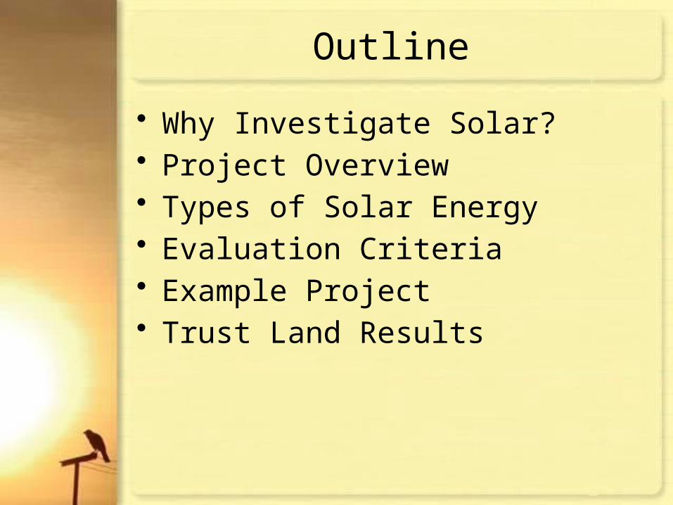
• Why Investigate Solar?• Project Overview• Types of Solar Energy• Evaluation Criteria• Example Project• Trust Land Results

Why Investigate Solar?
Image courtesy of Idaho Department of Lands Strategic Business Unit (2010)

Project Objective
• Determine “suitable sites” for solar development on Idaho’s state endowment trust lands
Deliverables• Suitable sites map• ArcReader document• Geodatabase• Parcel list of trust lands rank > 4. • Land rankings excluding specific criteria
including:– Asset Class– Distance to Transmission/Transportation– Wilderness

Uses and Applications
• Decision support for IDL regarding future solar development on trust lands.
• Supports Idaho’s legislative resolution for developing renewable energy.
• Renewable energy development cooperation with other states’ programs.

Concentrated Solar Power (CSP)
This work is in the public domain in the U.S. because it is a work of the U.S. Federal Government under the terms of Title 17, Chapter 1, Section 105 of the U.S. Code.
This image, which was originally posted to Flickr, was reviewed on 18:35, 2 October 2007 (UTC) by the administrator or reviewer Riana, who confirmed that it was available on Flickr under the Creative Commons Attribution 2.0 Generic License on that date.
PS10 Solar Power Tower, Seville, Spain
Parabolic Trough,Sandia National Laboratory, NM

Photovoltaic (PV)
This image or file is a work of a U.S. Air Force Airman or employee, taken or made during the course of the person's official duties. As a work of the U.S. federal government, the image or file is in the public domain.
Solar Power Plant, Nellis Air Force Base, NV

Analysis Criteria
• Solar Resource• Slope• Parcel Size• Species of Concern• Wilderness• Asset Classification• Proximity to Transmission• Proximity to Transportation

Solar Radiation
Rank kWh/m2/day
0 ≤3
3 >3 and ≤4
4 >4 and ≤5
5 >5
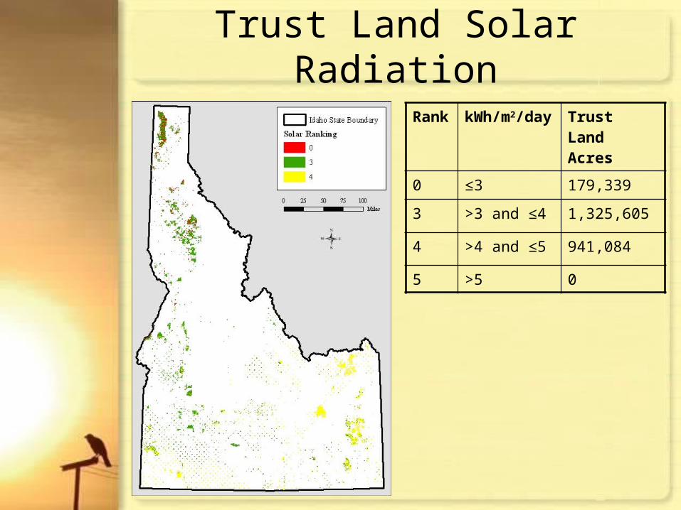
Trust Land Solar Radiation
Rank kWh/m2/day Trust Land Acres
0 ≤3 179,339
3 >3 and ≤4 1,325,605
4 >4 and ≤5 941,084
5 >5 0
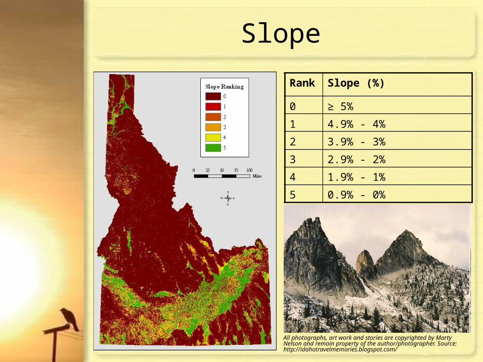
Slope
All photographs, art work and stories are copyrighted by Marty Nelson and remain property of the author/photographer. Source: http://idahotravelmemories.blogspot.com/
Rank Slope (%)
0 ≥ 5%
1 4.9% - 4%
2 3.9% - 3%
3 2.9% - 2%
4 1.9% - 1%
5 0.9% - 0%

Trust Land Slope
Rank Slope (%) Trust Land Acres
0 ≥ 5% 1,852,880
1 4.9% - 4% 82,867
2 3.9% - 3% 129,715
3 2.9% - 2% 169,531
4 1.9% - 1% 149,124
5 0.9% - 0% 61,912

Parcel Size Example (dissolve by asset class)
Rank
Parcel Size Acres
0 < 40 acres 7,273
5 ≥ 40 acres 2,438,248
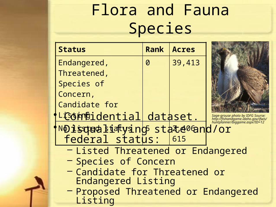
Flora and Fauna Species
Status Rank Acres
Endangered, Threatened, Species of Concern, Candidate for Listing
0 39,413
No listed status 5 2,406,615
• Confidential dataset.• Disqualifying state and/or federal status:
– Listed Threatened or Endangered– Species of Concern– Candidate for Threatened or Endangered Listing– Proposed Threatened or Endangered Listing– State Priority 1 or 2– Presence of Sharptail Grouse or Sage-grouse Leks
Sage-grouse photo by IDFG Sourse: http://fishandgame.idaho.gov/ifwis/huntplanner/biggame.aspx?ID=12
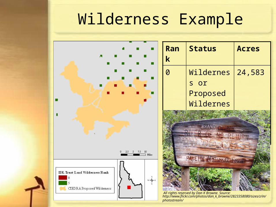
Wilderness Example
Rank
Status Acres
0 Wilderness or Proposed Wilderness
24,583
5 No listed status
2,421,445
All rights reserved by Dan K Browne. Source: http://www.flickr.com/photos/dan_k_browne/2823358080/sizes/z/in/photostream/

Asset Class Example
Rank Asset Class Acres
0 Minerals 5,750
1 Commercial 17,121
2 Forest Land 972,095
3 Conservation 22,489
4 Agriculture 39,179
5 Range Land 1,389,395
IDL GrazingSource: http://www.idl.idaho.gov/bureau/smr/range_crop/index.htm

Transmission/Transportation Proximity
• Confidential dataset. • ~ $1 million/mile for
new transmission lines.
0 Cost $25,675,000
5 Rank 0
0 Cost $25,000,000
0 Miles 25
Transmission
0 Cost $675,000
0 Miles 25
Transportation
Combined Ranking
• ~ $27,000/mile for new access roads.
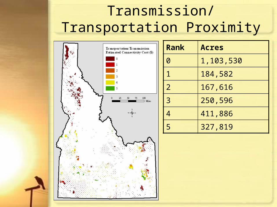
Transmission/Transportation Proximity
Rank Acres
0 1,103,530
1 184,582
2 167,616
3 250,596
4 411,886
5 327,819

MOA Consideration
218,170 acres are potentially restricted based on overlap of parcels with military operations areas.
Source: Source: http://www.mountainhome.af.mil/photos/mediagallery.aspU.S. Air Force photo by Master Sgt. Kevin J. Gruenwald

Grandview Solar One PV Project

Trust Lands Rank Results
Rank Acres
0 2,005,619
2 5,126
3 79,238
4 353,961
5 2,375
Total 440,700
Total within MOA 31,088
Total outside MOA 409,612
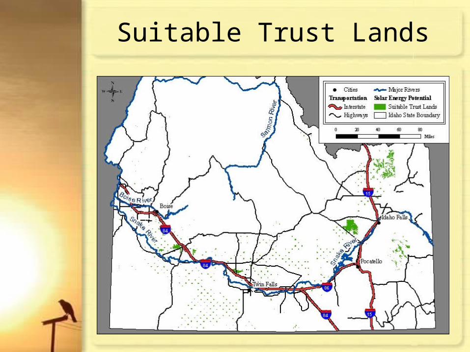
Suitable Trust Lands
Lessons Learned
• Including added value analyses such as proximity to water rights and transmission substations
• Next Steps… Site Visit• Species Buffers• Industrial Water Development Potential• Ranking w/o Parcel Size, Wilderness,
Species• Rasterize Datasets

Special Thanks
• Dr. Pat Kennelly, Visiting Associate Professor, PSU• Kate Langford, Strategic Business Analyst, IDL• Kathy Opp, Deputy Director, IDL• Chris Clay, GIS Manager, IDL • Dallas Rippy, Assistant Manager, New Mexico Renewable
Energy and Commercial Leasing Division • Paul Kjellander, Administrator, Idaho Office of Energy
Resources• Steve Silkworth, Project Manager, Avista Corporation• Bob Brammer, Assistant Director, IDL• Byron Schmidt, Chief Airspace Management, Mountain Home
Air Force Base• Dwain Rogers, Deputy Commissioner, Renewable Energy,
Texas General Land Office• Jeanne Holmgren, Chair of Surface Lands
Committee, Western States Land Commissioners Association

ReferencesGreen, B. (2010). Market growth for PV Solar vs. CSP: which is fastest. Retrieved from http://www.examiner.com/x-8178-Phoenix-Green-Business-Examiner~y2010m5d25-Market-growth-for-PV-Solar-vs-CSP-which-is-fastest on August 1, 2010.
ESRI. (2010). ArcGIS ArcEditor with Spatial Analyst v. 9.3.1 [computer software]. Redlands, CA: ESRI.
Gorrie, P. (2010). Homes with Solar Panels to get Subsidy. Retrieved from http://www.energyrefuge.com/archives/Solar_panel_subsidy.htm on December, 31, 2010.
Idaho Department of Lands (IDL). (2010). Endowment lands and asset classification. Retrieved from internal server on July 23, 2010.
Idaho Office of Energy Resources. (2010). Solar. Retrieved from http://www.energy.idaho.gov/renewableenergy/solar.htm on July 31, 2010.
Legislature of the State of Idaho. (2008). House Concurrent Resolution No. 54. Retrieved from http://legislature.idaho.gov/legislation/2008/HCR054.html on August 1, 2010.
Taylor, M. (2008). The Cost of Utility-scale Solar: PV vs. CST. Retrieved from http://www.renewableenergyworld.com/rea/news/article/2008/05/the-cost-of-utility-scale-solar-pv-vs-cst-52436 on August 1, 2010.
Van Coppenolle, L. (2010). Solar Energy Facts You Should Know. Retrieved from http://www.txses.org/solar/content/solar-energy-facts-you-should-know on December 31, 2010.
U.S. Department of Energy’s National Renewable Energy Laboratory (NREL) and U.S. Department of Agriculture, Forest Service (USFS). (2005). Assessing the Potential for Renewable Energy on National Forest System Lands. Retrieved from http://www.nrel.gov/applying_technologies/pdfs/assessing_re_potential_forest_lands.pdf on July 24, 2010.
U.S. Geological Survey (USGS). (1999). National Elevation Dataset (NED) for Idaho with a Horizontal Grid Spacing of 10-meters. Retrieved from http://insideidaho.org/default.htm on July 31, 2010.

Questions?