
Soils - Welcome to The Montana Department of...
14
Soils This section should address the types of soils in the project area susceptible to unwanted impacts of herbicide application, based on label statements. Create soil data maps and reports using Web Soil Survey or through the local NRCS office. Maps and reports must include: • soil types with soil descriptions • soil drainage class • soil erosion factors (K factor and Wind) • soil pH (if any herbicide label contains limitations in regards to soil pH). If the project is too large to read soil labels on the map, separate the project into several sections and create a map for each area.
Transcript of Soils - Welcome to The Montana Department of...

Soils This section should address the types of soils in the project area susceptible to unwanted impacts of herbicide application, based on label statements.
Create soil data maps and reports using Web Soil Survey or through the local NRCS office. Maps and reports must include: • soil types with soil descriptions• soil drainage class• soil erosion factors (K factor and Wind)• soil pH (if any herbicide label contains limitations in regards to soil
pH).
If the project is too large to read soil labels on the map, separate the project into several sections and create a map for each area.

Selecting Your Project Area (AOI)
• Navigate to USDA Web Soil Surveyhttp://websoilsurvey.sc.egov.usda.gov/App/WebSoilSurvey.aspx
• You MUST allow pop-ups to run thissite
1
• Navigate to USDA Web Soil Surveyhttp://websoilsurvey.sc.egov.usda.gov/App/WebSoilSurvey.aspx
• Select your project area as the Area ofInterest (AOI) by importing a shapefile(.shp) or zipped shapefile (.zip) ordrawing the area with the polygon tool
2

Saving Your Project Area (AOI)
• Save your project area (AOI) for use inArcGIS, Google Earth, or later use inWeb Soil Survey by exporting a zippedshapefile (.zip)
• Name your .zip file somethingrecognizable and download it
1
• Look for the .zip file folder in “Downloads”and save it someplace safe for later use
2

Soils and Soil Description
Once you have selected and AOI, click the Soil Map tab. If your AOI is too big, the map unit symbols will not appear in the image. You will need to break your project area into multiple smaller AOIs
1
• Click the Add toShopping Cart button.
• Enter the name of yourproject in the Subtitlebox and click OK.
2

Soil Texture and Rock Fragments
In the Soil Map view, look under the Map Unit Name to find texture and rock fragments
Click on the Map Unit Name to see a typical soil profile description
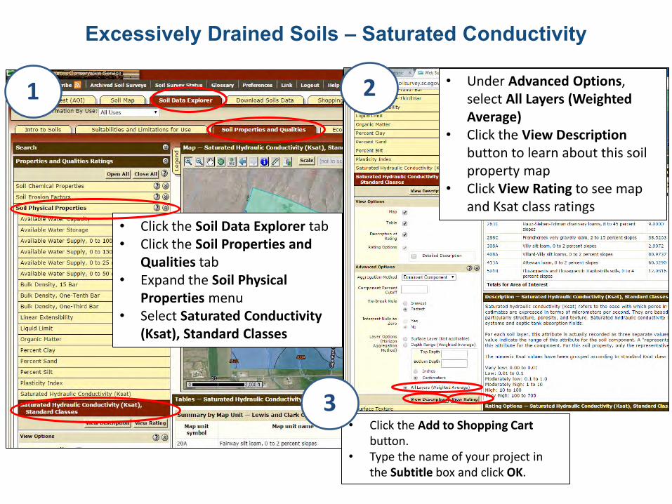
Excessively Drained Soils – Saturated Conductivity
• Click the Soil Data Explorer tab• Click the Soil Properties and
Qualities tab• Expand the Soil Physical
Properties menu• Select Saturated Conductivity
(Ksat), Standard Classes
1 • Under Advanced Options,
select All Layers (WeightedAverage)
• Click the View Descriptionbutton to learn about this soilproperty map
• Click View Rating to see mapand Ksat class ratings
2
• Click the Add to Shopping Cartbutton.
• Type the name of your project inthe Subtitle box and click OK.
3

Excessively Drained Soils – Drainage Class
• Click the Add to Shopping Cart button.
• Type the name of your project andin the Subtitle box and click OK.
3
• Close the Soil PhysicalProperties menu
• Expand the Soil Qualities andFeatures menu
• Select Drainage Class• Click the View Description
button to learn about this soilproperty map
• Click View Rating to see mapand Drainage Class ratings
1
• Click the Add to Shopping Cartbutton.
• Type the name of your project inthe Subtitle box and click OK.
2
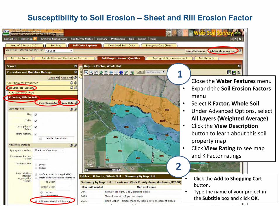
Susceptibility to Soil Erosion – Sheet and Rill Erosion Factor
• Close the Water Features menu• Expand the Soil Erosion Factors
menu• Select K Factor, Whole Soil• Under Advanced Options, select
All Layers (Weighted Average)• Click the View Description
button to learn about this soilproperty map
• Click View Rating to see mapand K Factor ratings
1
• Click the Add to Shopping Cartbutton.
• Type the name of your project inthe Subtitle box and click OK.
2

Susceptibility to Soil Erosion – Wind Erodibility Group
• Expand the Soil Erosion Factorsmenu
• Select Wind Erodibility Group• Click the View Description
button to learn about this soilproperty map
• Click View Rating to see mapand wind erodibility ratings
1
• Click the Add to Shopping Cartbutton.
• Type the name of your project inthe Subtitle box and click OK.
2

Get Your Custom Soil Report
• Click the Shopping Cart (Free)tab
• Select “Area of Interest Name“….” as your Subtitle choice
• Review the Report Table ofContents for each map andreport: soil map, K FactorWhole Soil, Wind ErodibilityGroup, Saturated HydraulicConductivity (Ksat) StandardClasses, Drainage Class, andDepth to Water Table
1
• Click the Checkout button andselect Download later as yourdelivery option
2
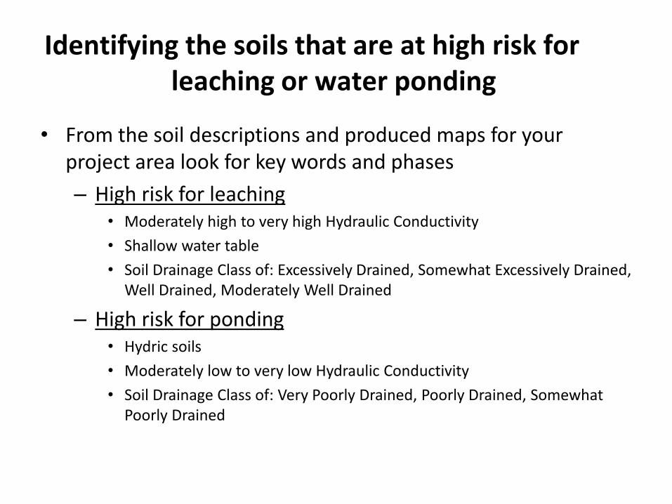
Identifying the soils that are at high risk forleaching or water ponding
• From the soil descriptions and produced maps for yourproject area look for key words and phases
– High risk for leaching• Moderately high to very high Hydraulic Conductivity
• Shallow water table
• Soil Drainage Class of: Excessively Drained, Somewhat Excessively Drained,Well Drained, Moderately Well Drained
– High risk for ponding• Hydric soils
• Moderately low to very low Hydraulic Conductivity
• Soil Drainage Class of: Very Poorly Drained, Poorly Drained, SomewhatPoorly Drained
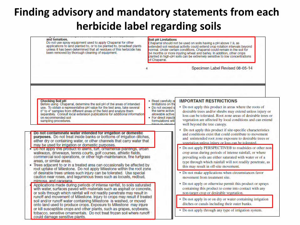
Finding advisory and mandatory statements from eachherbicide label regarding soils
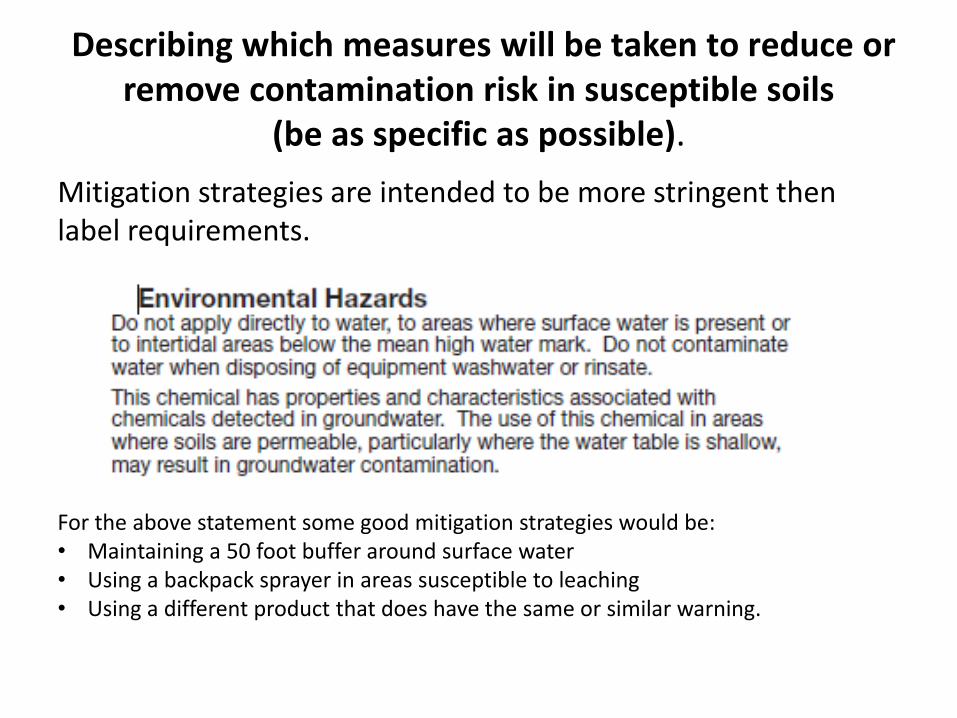
Describing which measures will be taken to reduce orremove contamination risk in susceptible soils
(be as specific as possible).
Mitigation strategies are intended to be more stringent then label requirements.
For the above statement some good mitigation strategies would be: • Maintaining a 50 foot buffer around surface water• Using a backpack sprayer in areas susceptible to leaching• Using a different product that does have the same or similar warning.