SOCIALIST REPUBLIC OF VIET NAM - World Weather...
30
SOCIALIST REPUBLIC OF VIET NAM COUNTRY REPORT ESCAP / WMO 40 TH SESSION OF THE TYPHOON COMMITTEE Macao, China, 21 - 26 November 2007 NATIONAL HYDRO-METEOROLOGICAL SERVICE
-
Upload
truonglien -
Category
Documents
-
view
219 -
download
0
Transcript of SOCIALIST REPUBLIC OF VIET NAM - World Weather...

SOCIALIST REPUBLIC OF VIET NAM
COUNTRY REPORT
ESCAP / WMO
40TH SESSION OF THE TYPHOON COMMITTEE Macao, China, 21 - 26 November 2007
NATIONAL HYDRO-METEOROLOGICAL SERVICE

2
CONTENTS
I. Overview of Meteorological and Hydrological Conditions during the Year
II. Meteorology
1. Progress in Member’s Regional Cooperation and Selected RCPIP Goals
and Objectives
2. Progress in Member’s Important, High-Priority Goals and Objectives
3. Opportunities for Further Enhancement of Regional Cooperation
III. Hydrology
1. Progress in Member’s Regional Cooperation and Selected RCPIP Goals
and Objectives
2. Progress in Member’s Important, High-Priority Goals and Objectives
3. Opportunities for Further Enhancement of Regional Cooperation
IV. Disaster Prevention and Preparedness
1. Progress in Member’s Regional Cooperation and Selected RCPIP Goals
and Objectives
2. Progress in Member’s Important, High-Priority Goals and Objectives.
V. Typhoons that impacted Vietnam

3
I. Overview of Meteorological and Hydrological Conditions during the Year 2007
1. Meteorological Assessment The meteorological conditions in Vietnam during 2007 have been very complicated with several extreme weather events occurred all over our country, especially in the Central part of Vietnam together with 2 tropical storms and 1 tropical depression that exerted their direct impacts on our territory.
Hot and dry weather condition occurred with less severe magnitude as compared to 2006. From late March to the end of June, many extended hot and dry spells (more than 10 days) occurred successively. In general, the average temperature from May to October was around and higher than average over the whole country.
The extreme weather phenomena such as whirlwinds, hails, severe thunderstorms, lightning occurred more frequently than in 2006, especially the hail storm occurred on November 2006 over North West mountainous areas of Vietnam. Until October of this year, 31 people were killed, 132 were injured and hundreds of houses were destroyed.
The TS No. 2 (NONAME) made landfall on Ha Tinh – Quang Binh area, not far from Ky Anh station, in the evening of 8th August. Although it was a small TS but had a very complicated track and it caused very serious damage to the central part of Vietnam (in term of human life, houses, traffics, aquaculture and agriculture). Note that this system was not classified as TS by other regional advisory Centers except Vietnam.
The TYP No. 5 (TYP. LEKIMA) made landfall on Ha Tinh – Quang Binh area in the evening of 3rd October. The effects of this tropical storm include the strong winds with the gale force 12, gusted over 12 (Beaufort scale) in the coastal areas of provinces from Thanh Hoa to Quang Binh, and a heavy rainfall spell in large areas of Central part of Vietnam. The Tropical Depression No. 6 was formed over the waters of south Central Vietnam on 29th October. It moved fast and made landfall on Binh Dinh province in the early morning of 30th October, bringing winds of force 7, gusted over 7 (Beaufort scale) in provinces from Quang Ngai to Binh Dinh. This tropical depression circulation caused heavy rainfall of 200-300mm for 2 days.
�
2. Hydrological Assessment During the period from 01st November 2006 to 15th November 2007 Viet Nam
was affected by large floods in Da, Hoang Long Rivers in the North and most serious flood, inundation in most rivers in the Central. Flood in the lower Mekong River in the South were lower than the annual average level. a) In the North:
During flood season of 2007, in most rivers such as Hong, Thai Binh rivers occurred many low flood but with the peaks nearly I-alert values. Especially, the large

4
floods in Da and Hoang Long Rivers occurred very lately were higher than the III-alert values and exceeding the historical flood.
Due to heavy rainfall by TYP No5 (LEKIMA) in combination with rather strong activity of southeast wind, from 03 to 06 October 2007, most serious, severe and complicated flood, inundation occurred in Son La, Hoa Binh, Ninh Binh provinces. The food peak in Hoang Long river at Ben De (Ninh Binh province) was 5,17 m (1:00, 6th October 2007), nearly the historical flood in 1985 (5,24m), exceeding the alarm level 3 by 1,17 m. At 12:00, 6th October 2007, the flood had to divert to 12 communes of 2 districts of Ninh Binh province.
In Da river, the inflow to Hoa Binh reservoir concentrated very quickly for only 12 hours from 2000 m3/s (at 16:00 of 4th October) to 14 500m3/s (at 07:00 of the 5th October) was biggest value in October during the recent 100 year period and the Hoa Binh reservoir had to open 6 spillway gates to downstream in 12 hours.
b) In the Central: Flood was very serious with successive and very high peaks, rather high flood rising intensity, flood water was concentrated very quickly and all these circumstances led to serious prolonged inundation in 12 provinces from Thanh Hoa to Ninh Thuan and the Highland. Particularly, within only more than one month from 1st October to 12th November 2007 in most rivers in Thua Thien Hue, Quang Nam, Quang Ngai, Binh Dinh, Phu Yen provinces, occurred 6 extremely big, historical floods such as: From 1 to 5 October, from 14 to 17 October, 21- 27 October, 30 – 31 October, 1-2 November and 3 – 5 November .
The Flood, inundation No-1 in early August 2007 Due to the affect of TS No2, from 05 to 08 August 2007, in most of coastal provinces of Central Viet Nam from Thanh Hoa to Thua Thien Hue heavy rainfall in a large area, in some places, extremely heavy rainfall with very high intensity was recorded.
The common total rainfall per spell varied from 600 to 800 mm; in some places, the value was higher 1000 mm, (Huong Khe: 1369mm, Tuyen Hoa: 1279mm, Dong Tam: 1042mm.
Historical, flash floods seriously occurred in whole Thanh Hoa, Nghe An and Gia Lai provinces. It was the biggest flood during the recent 50-60 year period: flood peak in Ngan Sau river at Chu Le was 16,13 m (6:00, 7th August 2007), exceeding the historical flood in 1996 by 0,71m, exceeding the alarm level 3 by 3,13 m; at Hoa Duyet, the value was 11,65 m (13:00, 8th August), exceeding the alarm level 3 by 1,65m; in Gianh river at Dong Tam was 18,34 m (21:00, 7th August 2007), nearly equaled to the historical flood in 1993, exceeding the alarm level 3 by 2,34 m; at Mai Hoa, the value was 9,47 m (23:00, 7th August), exceeding the alarm level 3 by 3,47m higher flood peak in 1963 by 0,64 m; in Krong Buk river at Krong Buk was 458,39 m (10:00, 8th August 2007), exceeding the historical flood in 1978 by 1,13m, exceeding the alarm level 3 by 2,08m.
In many other rivers in Central Viet Nam, big flood occurred with the peak exceeding the alarm level 3
Flood, inundation No-2 in early October 2007 Due to the affect of TYP No5 (LEKIMA) in combination with rather strong activity of southeast wind, from 03 to 06 October 2007, in Son La, Hoa Binh, Ninh Binh provinces of the North Viet Nam and in most of coastal provinces of Central Viet Nam occurred heavy rainfall in a large area.

5
The common total rainfall per spell varied from 350 to 400 mm; in some places, the value was higher 500 mm, (km46: 783mm, Hung Thi: 518mm, Bat Mot: 788mm. The heavy rainfall caused the most serious, severe and complicated flood, inundation:
- Flood rising intensity was very high, particularly, in rivers of Nghe An, Thanh Hoa, Ninh Binh, Son La provinces. At Quy Chau hydrological station, it was recorded that the average flood rising intensity was 50cm/h, the maximum value was 1,1 m/h; at Cua Dat, the average: 60 cm/h, maximum: 1,50m/h. Speed of flood run-off was the highest. - The flood amplitude was very big in rivers. The average flood amplitude was 8-10m during 12-24h, the maximum value at Quy Chau station of Hieu River (Nghe An province) was 12 m; at Thach Thanh station of Buoi River (Thanh Hoa province) was 10,25 m; at Hoi Xuan station of Ma River (Thanh Hoa province) was 13 m. - Flood peaks in rivers were very high
Historical flood occurred in some rivers (in the recent 50-70 year period): Water level at flood peak in Buoi river measured at Thach Thanh was 14,25 m (at 01:00 of the 6th October), higher the historical flood in 1985 by 0,26 m; in Ma river at Cam Thuy, the value was 21,87 m (at 20:00 of 6th October) higher the historical flood in 1975 by 0,16 m; at Ly Nhan – 13,24m (at 4:00 of 6th October) higher the historical flood in 1973 by 0,41 m, at Giang – 7,28m (at 4:00 of 6th October) nearly the historical flood in 1983 (7,51m), exceeding alarm level 3 by 0,78 m; in Hieu River at Quy Chau was 80,19 m (4:00, 5th October 2007), exceeding the historical flood in 1988 by 0,14m.
This serious flood in Thanh Hoa province caused a break of the dyke in Buoi river and the secondary dam of Cua Dat reservoir in Ma river led very serious inundation in large area.
In many other rivers in Central Viet Nam, big flood occurred with the peak exceeding the alarm level 3 by 0,17-0,75m such as Huong (Thua Thien Hue province), Thach Han (Quang Tri province), Kien Giang and Gianh (Quang Binh province) rivers.
Flood, inundation No 3 in early November 2007 Due to the affect of TS N-6 (PEIPAH) in combination with rather strong activity of southeast wind, from 09 to 13 November 2007, in most of coastal provinces of Central Viet Nam from Thua Thien Hue to Binh Dinh, occurred heavy rainfall in a large area.
The common total rainfall for 4 days varied from 500 to 700 mm; in some places, the value was higher 800 mm, such as Nam Dong: 1773mm, Thuong Nhat: 1248mm, A Luoi: 834mm. The heavy rainfall caused the most serious, severe and complicated flood, inundation:
The peak floods were extremely big, nearly historical flood in some rivers The flood peak in Han River at Cam Le station (Quang Nam province) was
3,98 m (at 19:00 of the 12th November), nearly the historical flood in 1999, exceeding the alarm level 3 by 2,28 m; in Vu Gia River at Ai Nghia station (Quang Nam province) was 10,36 m (at 08:00 of the 12th November), higher the historical flood in 1999 by 0,09m, exceeding the alarm level 3 by 1,56 m; in Thu Bon River at Cau Lau station (Quang Nam province) was 5,39 m (at 11:00 of the 12th November), higher the historical flood in 1999 by 0,16m, exceeding the alarm level 3 by 1,69m, at Hoi An station was 3,28 m (at 15:00 of the 12th November), higher the historical flood in 1999

6
by 0,07m, exceeding the alarm level 3 by 1,58m; in Auyn River at PMoRe station (Gia Lai province) was 678,03 m (at 22:00 of the 10th November), higher the historical flood in 1984 by 1,31m.
The flood peak was higher than III-alert value in many rivers of 10 provinces, such as Thach Han River at Quang Tri station (Quang Nam province) (0,6m), Bo River at Phu Oc station (Thua Thien Hue province) (0,33), Ve river at Ve station (Quang Ngaii province) (0,99m), Lai Giang River at Bong Son station and Kon river at Thach Hoa station (Binh Dinh province), Ba River at Cung Son station and Da Rang river at Phu Lam (Phu Yen province), Cai Nha Trang River at Dong Trang station (Khanh Hoa province), Cai Phan Rang River at Tan My and Phan Rang stations (Ninh Thuan province), DacBla River at Kon Tumi station (Kon Tum Nam province),...
c) In the South: In the lower Mekong River, the flood occurred more lately than 1 month compared with the annual average at Tan Chau and Chau Doc stations. The flood lasts from the end of July to 31st October. Flood peaks occurred in 24 October 2007 and were lower the alarm level 3 by 0,12 m.
Table 1. Number of floods in the main river basins of Vietnam (01 November 2006 to 15 November 2007)
No
River Basin
Number of floods
No
River Basins
Number of floods
01 Da 12 12 La 2 02 Thao 14 13 Gianh 3 03 Lo 15 14 Huong 5 04 Red River 8 15 Thu Bon 5 05 Thai Binh 7 16 Tra Khuc 5 06 Cau 7 17 Kon 3 07 Thuong 7 18 Cuu Long 1 08 Luc Nam 7 19 Serepok 3 09 Hoang Long 4 20 10 Ma 1 21 11 Ca 3 22

7
Figure 1: The points with flood peaks higher than III alert in 2007

8
Table 2. Characteristics of largest floods in the main rivers (01 November 2006 to 15 November 2007)
No Station River Max Water
level, cm Day/month/
year Duration of flood (days)
01 Ha Noi Hong 987 6 Aug. 2007 0 02 Yen Bai Thao 3138 5 Oct. 2007 0 03 Tuyen Quang Lo 2217 8 Jul. 2007 0 04 Hoa Binh Da 14500 m3/s 5 Oct. 2007 2 05 P.L.Thuong Thuong 393 7 Aug. 2007 3 06 Luc Nam Luc Nam 476 6 Jul. 2007 1 07 Dap Cau Cau 394 7 Aug. 2007 2 08 Pha Lai Thai Binh 399 7 Aug. 2007 3 09 Ben De Hoang
Long 517 6 Oct. 2007 3
10 Giang Ma 728 6 Oct. 2007 1 11 Nam Dan Ca 796 8 Oct. 2007 3 12 Linh Cam La 547 9 Aug. 2007 1 13 Mai Hoa Gianh 948 7 Aug. 2007 1 14 Hue Huong 423 16 Oct. 2007 2 15 Cau Lau Thu Bon 382 2 Nov. 2007 2 16 Tra Khuc Tra Khuc 772 4 Nov. 2007 2 17 Tan An Kon 891 5 Nov. 2007 1 18 Phu Lam Da Rang 429 4 Nov. 2007 1 19 Tan Chau Tien
(Mekong) 408 23 Oct. 2007 30
20 Chau Doc Hau (Mekong)
356 24 Oct. 2007 30
21 Ban Don Serepok 17610 5 Aug. 2007 1 �
d) Flash Floods: Twelve flash floods occurred in 8 provinces in the North and Central Vietnam such as Lao Cai (17th May, 3rd Nov.), Cao Bang (3rd Sep.), Bac Kan (14th Sep.), Son La (30th June), Lai Chau (6th , 27th July), Ha Giang (18thJune, 29th June, 3rd Sep.),Thanh Hoa (6th July). The flash floods caused extreme damages on human lives and properties to these provinces

9
Figure 3: The provinces where flash floods occurred in 2007
Cao Bang (3 May)
Bac Kan (14th Sep)
Phu Tho (6th July)
Lai Chau (6th , 27th July)
Ha Giang (18thJune, 29th June, 3rd Sep.)
Thanh Hoa (6th July)
Lao Cai (17th May, 3rd Nov.)
Son La (30th June)

10
Socio-economic Assessment
Heavy rains and tropical storms followed by floods and flash floods caused major damage during summer 2007. The government has made every efforts and taken necessary measures for the prevention and mitigation of natural disaster. Due to TS No. 2 (NONAME), historical floods on Gianh and Krong Buk rivers was set and exceeded 0.64m and 1.13m the previous one on 1993 and 1978 respectively; 77 people were reported dead, 123 injured, 6 missing people; 1 473 houses were collapsed and damaged; 51 ships were sank; 67 132 ha of rice field were flooded. Due to TYP No. 5 (LEKIMA), the floods on some rivers in north Central Vietnam (Buoi and Ma rivers…). As a result, 88 people died, 180 injured and 8 missing people; 1 853 houses were collapsed and damaged; 46 ships were sank; 8 849 ha of rice fields were flooded. Although Tropical Depression No. 6 was formed and developed in a short time but its circulation caused heavy rains and floods in many rivers along the south of Central Vietnam. As a result of that, 07 people died, 01 missing and 92 injured people; 886 houses were damaged; 9416 ha of rice were flooded and damaged.

11
II. Meteorology 1. Progress in Member’s Regional Cooperation and Selected RCPIP Goals and
Objectives:
a. Hardware and Software Progress
a.1 Observation network: NIL a.2 Technical advancement • Visible and other imageries from MTSAT (JMA) were used in operational
forecasting. • Microwave imagery from the US Naval Research Laboratory website was used to
support forecasters in locating the TC intensity and position a.3 Data exchange: NIL a.4 Numerical Weather Prediction • The High Resolution Model (HRM) is operationally running with the increased
horizontal resolution of 14km x 14km with the initial and boundary conditions interpolated from the DWD’s global model GME. From 24 October, 2007, the multi-layer soil model comprises seven active layers for the heat (energy) and six for the soil moisture (water) budget has been used in GME.
a.5 The use of ensemble products • Multi-model ensemble and consensus forecasts of tropical cyclone tracks are
used during the course of producing tropical cyclone warnings. The picture below illustrates probability forecast 24h and 48h conducted from forecasts system of kilo-members ensemble based on WBAR model.
Fig 4: Example of accumulated probability forecast 24h and 48h conducted from
forecasts system of kilo-members ensemble based on WBAR model
(a) (b)
12
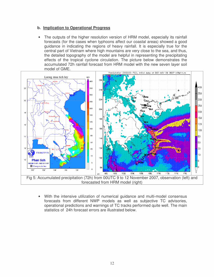
b. Implication to Operational Progress • The outputs of the higher resolution version of HRM model, especially its rainfall
forecasts (for the cases when typhoons affect our coastal areas) showed a good guidance in indicating the regions of heavy rainfall. It is especially true for the central part of Vietnam where high mountains are very close to the sea, and thus, the detailed topography of the model are helpful in representing the precipitating effects of the tropical cyclone circulation. The picture below demonstrates the accumulated 72h rainfall forecast from HRM model with the new seven layer soil model of GME.
Fig 5: Accumulated precipitation (72h) from 00UTC 9 to 12 November 2007, observation (left) and
forecasted from HRM model (right) • With the intensive utilization of numerical guidance and multi-model consensus
forecasts from different NWP models as well as subjective TC advisories, operational predictions and warnings of TC tracks performed quite well. The main statistics of 24h forecast errors are illustrated below.

13
Mean Error (km)
24h 48h DPE 135.4 281.2
No.Cases 128 53
c. Interaction with users, other Members: NIL d. Training Progress
• 1 staff from NHMS attended the WMO’s Training course on Tropical storms’ damage reduction in China from 26 to 31 March 2006.
• 1 staff from NHMS attended the Training program on Disaster Prevention and Preparedness in Taiwan from 5 – 11 May, 2007.
• 1 staff from NHMS attended Climate Prediction and application in Asia - Pacific at Singapore, from 21 to 31 May 2007.
• 2 staffs from NHMS attended Integrated Workshop on Social – Economic Impacts of Extreme Typhoon – related Events in Thailand from 10 – 14 Sep 2007.
• 1 staff from NHMS attended to work on the project “Using ensemble prediction system (EPS) information in tropical cyclone forecasting: under the fellowship scheme in Hong Kong Observatory from Sep to Nov 2007.
• 3 staffs attended The Typhoon Committee Roving Seminar 2007: Doppler radar analysis (rain and wind), Satellite Analysis (Quikscat and Microwave Imageries), Interaction of Tropical Cyclones with Monsoon Systems in Philippines from 5 – 8 Sep 2007
e. Research Progress: NIL f. Other Cooperative Progress: NIL

14
2. Progress in Member’s Important, High-Priority Goals and Objectives
a. Hardware and Software Progress
a.1 Observation network
• Complement 47 Young wind measurement for coastal and island stations.
• Installed 3 barometers for island stations
• Add 11 flow measurements for 11 stations in the whole country a.2 Software for interactive operational forecasting • The GEMPAK/N-AWIPS package from UNIDATA/UCAR has been installed,
studied and undergone the adaptation to be used with the data feed from local sources at NCHMF.
• New tropical storms forecast supporting software, TCAids, was designed and
installed for operational works.
Fig 6: Example of new forecaster supporting software, TCAids
b. Implication to Operational Progress • Establishing a good relationship with the national television channels to improve
the weather forecast programs’ contents and quality. Forecasted parameters,

15
fields and forecast discussions are automatically sent to the TV and the Central Committee for Flood and Storm Control (CCFSC).
• In the case of extreme weathers such as tropical cyclone, more details are provided to the TV weather interpreters so that the weather situations can be better explained to the public. As a result, the weather forecasts as well as tropical cyclone warnings have become more popular and understandable to the public.
• PC-Linux Cluster system (8 nodes, 16CPUs, RAM 16GB (2x8) has been put into operation at NCHMF since May, 2007. This system has replaced the old one (4 nodes, 8CPUs that had been out of service in May.
• The numerical model MM5 was applied to tropical cyclone track and intensity forecasts. The figure below shows the graphic map based on MM5’s output
Fig 7: Example of MM5’s TC track forecast
c. Training Progress d. Research Progress
• Research on the implementation of 3D-VAR data assimilation scheme for HRM
model using conventional observations is being carry-out and will be put into operation in the 1st quarter, 2008.
The picture bellows illustrates analyzed mean sea level pressure (MSLP) from original GME model (left) and after applying 3D-VAR assimilation scheme (right)

16
Fig 8: MSLP at 00UTC-30/09/2006 during TYP. XANGSANE (0615) (112.3°°°°E, 15.5°°°°N, observed pressure was 955 hPa) from original HRM model (HRM_GME, left) and after applying 3DVAR
scheme (3DVAR_DFI, right) • Research on applying Weather and Research Forecasting (WRF) model for
tropical storm track forecasts.
Fig 9: Direct Position Error (DPE) for 5 typhoon seasons (2003-2006) and
averaged over whole period based on the analyzed data (518 cases of 31 TS)

17
Fig 10. Direct Position Error (DPE) for typhoon season 2006 for 4 TC Cimaron,
Chebi, Durian, Utor and averaged over 4 TCs (real-time forecast)
• Research on applying the ensemble and consensus forecast for tropical storm
tracks
Fig 11: STAMP maps of the geopotential height at 850hPa valid at 00UTC 2 August 2005 (Initial time at 00UTC-30 July 2005) from multi-models and the
ensemble result (bottom, right) after removing bias

18
e. Other Cooperative Progress NIL 3. Opportunities for Further Enhancement of Regional Cooperation
NIL

19
III. HYDROLOGY 1. Progress in Regional Cooperation and Selected RCPIP Goals and 1. Progress in Regional Cooperation and Selected RCPIP Goals and Objectives: NIL 2. Progress in Member’s Important, High-Priority Goals and Objectives:
a.1 Observation network • Established the flash flood warning system with 7 automatic rainfall gauges in
Ngan Sau and Ngan Pho rivers of Ha Tinh province.
Bangkok, Thailand, 10 – 14 September 2007
������������� ������ �� � �� � �� ��� �����
����������������������� ��������������� ����� �� � �� �� �� ������������������������������������ �������� ��� �����������
� ��� ����������
• Established the flash flood warning system with 2 automatic rainfall gauges in
Ngoi Lao and Ngan Pha rivers of Yen Bai province.

20
Bangkok, Thailand, 10 – 14 September 2007
� � ��� ! ����"���� ��� � #$%#�&��
! ����'�� �� �(%�&�
� � '���! ����"��������� � ����� �� � � ������������� ���
a.2 Technical advancement - Improvements of software in data processing and analysis: Continued to develop the software for the preservation of hydro-meteorological database, for hydrological data collection, processing and timely transmitting hydrological information and forecasts to end-users.
- Develop some software for automatically input and output of the new hydrological
models MARINE, FIRR, Hydraulic model and model for reservoir’s regulation.

21
- Improvements in hydrological forecast models:
Empirical method For all rivers Mike-11 model (Danish model) Lower Red river Marine model (French) Da river TANK model (Japanese)+Muskingum+Cung (Vietnamese)
For Short-range and for medium flood forecasting in most rivers of the North Viet Nam
NAM model (Danish model)+ Muskingum Ca River in the Central Vietnam 1-D Hydraulic model (TL2) (Vietnamese) Lower Red river Reservoir Flood Routing (Vietnamese) For Hoabinh Reservoir operation HydroGIS (Vietnamese) Lower Mekong river WETSPA (Belgium model) Thu Bon – Vu Gia river in the Central
Vietnam
Hydrological model for Ca River in the Central Viet Nam

22
Hydraulic model for lower Red River 1. Employ the MARINE and FIRR models to forecast flow in upstream area of Da, Thao, Lo rivers, Reservoir Flood Routing model for reservoir’s regulation in Da river and create the input for the Hydraulic model TL2 in lower stream of Red river.
Hydrological forecasting
2. Developing the TANK Model for flood forecasting with lead time 120h and time step of 6h since flood season of 2005

23
for flood forecasting with lead time 120h
3. Developing MIKE-11 Model for flow forecasting with lead time 48h in the lower Red river.
4. Developing the HydroGIS model for flood forecasting with lead time 5 days in lower Mekong River.

24
b. Implications to Operational Progress - In 1 June 2007 year, the Prime Minister promulgated the guideline for operation 3
reservoirs: Hoa Binh, Thac Ba, Tuyen Quang. It is implemented for flood season of this year (2007).
c. Interaction with users, other Members, and/or other components - Improvement of hydrological products to meet users’ requirements and expectation:
1. Improvement of hydrological forecasting products for Hoa Binh (in Da River) and Tuyen Quang hydro-electric power regulation and Tuyen Quang (in Gam River).
2. Improvement of hydrological forecasting products for the building of new hydro-electric power Son La in Da River and Huoi Quang, Ban Chat reservoirs in Nam Mu river.
d.Training Progress
1. One staff attended the International workshop on technologies of assessment and improvement operation of flood forecasting system, Seoul, Korea from 05th to 07th February 2007.
������������
Nguyen Huu Nhan
����� �� � �� � ����
� � � � �� � �� �� �� � �����
�� ����� ����� ������ ���
�����������

25
2. One staff attended the International Conference on Every five year flood reports in the Mekong River commission in Cambodia at 12th February 2007.
3. One staff attended the Technical Training course on Flood forecasting and data management of Hydro-meteorological observation system in Cambodia from 28th May to 5th June 2007.
4. One staff attended the training program for mitigation of flood, typhoon-related natural disaster in Taiwan from 7th to 11th May, 2007
5. One staff attended the training workshop on Flood forecasting system in Beijing, China from 15th to 21st October, 2007
6. Three staffs attended the 3 months - training course on using of Mike - 11 model in DHI, Denmark, from 2nd November 2007 to 2nd January 2008.
7. One staff attended the training course on Flood control and management in Berlin, Germany from 18th October to 08th November 2007.
8. One staff attended the training course on River environment control in Sweden from 05th to 23rd November 2007
e. Research Progress. • Continued project "The guideline for the operation 4 hydropower in Da and Lo
rivers". Its deadline is expected to be by the end of March 2007. Currently, in Vietnam were being built 30 hydropower dams at upstream of the
main rivers, especially the multipurpose ones such as:
� Son La Reservoir in Da River is expected to be commissioned by the year 2008.
� Ban Trac, Quang in Da River, Na Le (Chay River), Bao Lac (Gam River), Lai
Chau (Da River) reservoirs (2013).
• 2 projects are continuous executing:
- Flash flood mapping Project with purposes: drawing up of flash flood map and establishing flash flood warning system in the North Viet Nam (the first phase 2006-2008 in Ha Giang provinces with more than 70 automatically rainfall stations)
- Establish the alerts system of water level in Vietnam.
• On-going National Project: Development and application of the American
NWSRFS Model for Flood and inundation forecasting and warning in Hong – Thai Binh river system.
• On-going Ministry Project: Development of flood prediction and inundation
warning technology in Ve – Tra Khuc river system, the technological experiment and transfer.
• On-going Ministry Project: Development of 5-day flow prediction technology to
large reservoirs in Da and Lo river system.

26
• On-going Ministry Project: Development and application of the WETSPA and HECRAS for flood simulation and prediction in Thu Bon – Vu Gia river system.
f. Other Cooperative/RCPIP Progress. Existing agreements between China Government, Mekong committee and Vietnam NHMS for exchanging the hydrological data from China, Thailand, Laos and Cambodia. Existing cooperation between HMS Vietnam and DHI for using Mike-11 model to flood forecasting.
3. Opportunities for Further Enhancement of Regional Cooperation NIL

27
������������� �������������������������
1. Progress in Member’s Regional Cooperation and Selected RCPIP Goals and Objectives:
a. Hardware and Software Progress NIL
b. Implication to Operational Progress NIL
c. Interaction with users, other Members NIL
d. Training Progress • Some training courses on Natural Disaster Prevention and Preparedness have
been organized for communities and local staffs at Dien Bien, Thua thieen – Hue, Ben Tre with the help of ChurchWorld Service, Oxfam – Hong Kong…
• Two staffs of CCFSC attended training course the Advanced seminar on Puplic Health and Medicine on Emergency Situations for the Asian Expert to be held on 4 – 10 June,2007 in Jakarta, Indonesia.
• One staff of CCFSC attended ASEAN Regional disaster Emergency Response Simulation Exercise ( 22-25 Oct, 2007).
• One staff of CCFSC attended Workshop on Disaster Risk Reduction 23-27. Oct, 2007 in Chiang-mai, Thailand help by Help Age International Asia/ Pacific Regional Development Center.
• One staff of CCFSC attended Regional Workshop on Innovative Approaches to flood Risk Reduction in the Mekong Basin, 17-19 Oct, 2007 Khon Kaen, Thai Lan.
• One staff of CCFSC attended training on Post-Disaster recovery and rehabilitation Management in Beijing, China 19/11-3/12- 2007.
e. Research Progress NIL
f. Other Cooperative Progress NIL 2. Progress in Member’s Important, High-Priority Goals and Objectives:
a. Hardware and Software Progress NIL
b. Implication to Operational Progress
• Regular maintaining and upgrading the dikes systems and hydraulic structures for dyke system in Bac Bo area and northern part of Central Viet Nam.
• Continue the Riverbank Erosion Control program by building new riverbank protection’s structure.
• Implement the emergency relief and recovery program for overcome disaster consequences.
• Implement the bamboo’s planting to protect dykes from water’s waves. • Implement a program to relocate residents living in disaster prone areas • Implement a program to improve the safety for fisherman.

28
• Workshop of Strategic plan on CBDRM, 9-10 August 2007, Ha Noi, Viet Nam).
• Relocated people & social-economic development Program in disaster prone areas, extremely difficult areas, border areas, island areas, unplanned migration, critical areas of protective forest from 2006-2010. A project for transferring and resettling people from low areas and prone - landslide areas has been carried out in almost provinces.
• Strengthening and improve sea dike in the Northern part of Vietnam from Quang Ninh province to Quang Nam province, on-developing program for the Southern part of Viet Nam from Quang Ngai to Kien Giang
c. Interaction with users, other Members • A special program has been settled up at Viet Nam Television (Channel 2) to
propagate knowledge and raise the community awareness on natural disasters.
d. Training Progress • Workshop on integrate indicators related to children into natural disaster
statistical data (June, 2007, Ha Noi, Viet Nam). • Workshop on sharing experience in building and implementing disaster risk
reduction projects according to the integrated approaches, 23 April 2007, Danang city, Vietnam.
• Workshop on flash flood for the mountainous areas in the Northern of Viet Nam, Mong Cai town, Viet Nam.
e. Research Progress NIL f. Other Cooperative Progress NIL 3. Opportunities for Further Enhancement of Regional Cooperation NIL

29
Summary report on damage caused by disaster in Vietnam in 2007 (Until 15 October 2007)
CATEGORY ITEM DAMAGED UNIT Whirlwind Flood Tropical
cyclones TOTAL PEOPLE Killed No 31 172 167 370
Injured No 132 81 303 516 Missing No 1 18 14 33
HOUSING Houses collapsed, drifted No 594 3.372 3.336 7.302 Houses submerged and
damaged No 11.966 390.416 153.488 555.870
SCHOOL Schools collapsed Room 46 1 1.156 1.203 Schools submerged and
damaged Room 286 816 1.582 2.684
HOSPITAL, CLINICS Clinics collapsed No 20 1 12 33 Clinics submerged and
damaged No 29 248 806 1.083
AGRICULTURE Rice fields submerged Ha 27.399 19.725 115.122 162.246
Farms submerged, damaged
Ha 3.470 31.194 168.991 203.655
Food damaged by water Ton 0 245 43.675 43.920
WATER RESOURCES
Land washed away m3 0 1.285.015 1.956.504 3.241.519
Stone drifted m3 0 9.778 137.580 147.358 Dykes slumped m 410 30.635 21.308 52.353 Small hydraulic structures
collapsed unit 1 131 132
Small hydraulic structures damaged
unit 10 448 752 1.210
TRASPORTATION Land drifted m3 600 1.574.180 2.644.979 4.219.759
Rock drifted m3 7.456 21.698 29.154
Bridge, sewer collapsed unit 0 17 316 333 Bridge, sewer damaged unit 3 397 1.674 2071 Roads damaged Km 0 101 154 255
AQUATIC PRODUCT Shrimp, fish poll broken ha 45 4.181 13.872 18.098 Ships sunk, lost unit 0 242 1.610 1.852 Ships sunk, damaged unit 5 122 108 235
COMMUNICATION Telephone poles collapsed
unit 75 31 1.371 1.477
Telephone wire broken m 3.300 100 167.600 171.000 ENERGY High voltage electric
towers broken unit 27 0 36 63
Electric distribution poles broken
unit 328 507 7.206 8.041
Electric wire broken m 13.370 300 385.678 399.348 Total damage USD 74
millions 1.378 millions
5.734 millions
7.186 millions

30
SOCIO – ECONOMIC IMPACTS
�
���
���
���
���
���
���
���
�� � ��� � ��� ������� ���� ����
� � �������� ������ ��� ��� ��!� ���" ����#" � ����$ %& '
V. TYPHOONS THAT IMPACTED VIETNAM IN 2007 The tropical storms and depressions that affected Viet Nam in 2007 are summarized in the table below
Name Duration Max wind at landfall
(m/s) Place of landfall
TS No. 2 NONAME 1 Aug - 9 Aug 13, gust 20 Ky Anh (Ha Tinh)
TYP No. 5 TYP. LEKIMA 29 Sep - 4 Oct 36, gust 40 South Ky Anh
(Ha Tinh – Quang Binh) TD No. 6
29 - 30 Oct 14, gust 19 Quy Nhon (Binh Dinh)