SOCIALIST REPUBLIC OF VIET NAM - Typhoon Committee
20
MEMBER REPORT ESCAP/WMO Typhoon Committee 15 th IWS SOCIALIST REPUBLIC OF VIET NAM November 2020
Transcript of SOCIALIST REPUBLIC OF VIET NAM - Typhoon Committee

MEMBER REPORT
ESCAP/WMO Typhoon Committee
15th IWS
SOCIALIST REPUBLIC OF VIET
NAM
November 2020

i
CONTENTS
I. Overview of tropical cyclones which have affected/impacted Member’s
area since the last Typhoon Committee Session ..................................................... 1
1.1. Meteorological assessment ..................................................................... 1
1.2. Hydrological Assessment ........................................................................ 4
1.3. Socio-Economic Assessment ................................................................... 9
1.4. Regional Cooperation Assessment (highlighting regional
cooperation success and challenges. ...................................................................... 10
1.4.1 Hanoi Regional Forecasting Support Centre (RFSC) of the
Severe Weather Forecasting Project (SWFP) .............................................. 10
1.4.2. Other collaborations ................................................................ 10
II. Summary of Progress in Priorities supporting Key Result Areas ..... 12
2.1. Central Data Hub, HPC and forecast supporting system ................. 12
2.2 Impact-based forecast in Viet Nam ...................................................... 14
2.3 Short-rangeRegional Ensemble Prediction System (SREP-32) ......... 16

1
I. Overview of tropical cyclones which have affected/impacted
Member’s area since the last Typhoon Committee Session
Since the beginning of 2020 until now, natural disasters have happened
complicatedly and abnormally in many regions of Vietnam. There have been
16 types of natural disasters: 13 storms in the East Sea; 263 thunderstorm
heavy rain events in 49 provinces / cities of which 09 events were on a large
scale in 21 provinces in the North and Central part of Vietnam; 101 flood,
flash flood, landslides events; especially the historical flood from October 6-
22 in the Central region, especially in the provinces from Ha Tinh to Thua
Thien Hue; droughts, severe saltwater intrusion, riverbank and coastal
erosion, sea dyke subsidence in the Mekong Delta , ...
1.1. Meteorological assessment
From the beginning of the year to the end of November 2020, 13 storms
and 01 tropical depression appeared in the East Sea. In which, there are 01
tropical low pressures and 08 storms that directly affect the Vietnamese
mainland, specifically: Typhoon No. 2 (Sinlaku), typhoon No. 5 (Noul),
typhoon No. 6 (Linfa), typhoon No. 7 (Nangka), Storm surge in October,
typhoon No. 8 (Saudel), typhoon No. 9 (Molave), storm No. 10 (Goni), storm
No. 12 (Etau) and storm No. 13 (Vamco). In addition, there are 03 storms that
do not affect Vietnam: typhoon No. 1 (Nuri), typhoon No. 3 (Mekkhala),
typhoon No. 4 (Higos) has landfall in China.
Most of the landfall storms in 2020 has moved west and northwest,
typhoon 6 and typhoon No. 9 are the two fastest moving storms with a speed
of 25-30km/h. Till the end of October, Typhoon No. 9 (Molave) was assessed
to have the strongest intensity that directly affected Vietnam. The storm has
maximum intensity of level 13, gust 15 over East Sea, when landing on the
Vietnam coastal area, it caused strong winds of force 11-12, Binh Chau and
Ly Son (Quang Ngai) stations recorded strong winds of force 11-12, gust 13-
14; Other stations from Quang Tri to Binh Dinh are also observed strong wind
of force 8, gust 10.
Notably, October is the month with the highest storm frequency in
2020, with 04 storms which all directly affect the Central provinces. The
successive storms combined with the cold air activity caused heavy rains and
big floods, flash floods and landslides, in the central regions of Vietnam
causing great damage to life and assets.
Table 1. Statistics on tropical cyclones in 2020

2
TS Name
(International
Name)
Maximum
intensity
(Beaufort
scale)
Maximum
observed
windspeed
Total rainfall
TS. Number 2
(Sinlaku)
Wind force
level 8, wind
gusts level 10
Hòn Dấu
21m/s (level
9) strong
wind gusts 25
m/s, (level
10), Văn Lý
19m/s ( level
8), strong
wind gusts
(level 9)
From July 31st to Aug 03rd,
Total rainfall in the
provinces from Thanh Hoa
to Quang Tri about: 200-
400mm, some places up to
higher 500mm; Central
Highlands, Southeast and
Mekong River Delta: 100-
200mm, some places up to
higher 250mm.
TS. Number 5
(Noul)
Wind force
level 10,
wind gusts
level 12
Cửa Tùng:
23m/s (level
9), strong
wind gusts
26m/s (level
10), Hải
Lăng: 20m/s
(level 8),
strong wind
gusts 26m/s (
level 10)
On Sep 17-19, total rainfall
in the provinces from Nghe
An to Quang Ngai: 100-
300mm, some places up to
higher 300mm
TS. Number 6
(Linfa)
Wind force
level 8, wind
gusts level 10
Lý Sơn :
18m/s (level
8) strong
wind gusts
24m/s (level
9), Tam
Thanh 15m/s
(level 7),
strong wind
gusts 20m/s
level 8
On Oct 10-11, total rainfall
in the provinces from Thua
Thien Hue to Quang Ngai:
150-350mm, some places up
to higher 350mm.
TS. Number 7
(Nangka)
Wind force
level 10,
wind gusts
level 12
Bạch Long
Vỹ 23 m/s
(level 9)
strong wind
gusts 29 m/s
(level 11),
Văn Lý 20
m/s (level 8)
On Oct 13-16, total rainfall
in the Northeast and Red
River Delta, Hoa Binh
Province, South Son La
Province, Yen Bai Province,
Phu Tho Province, Vinh
Phuc Province and North
Center: 100-300mm.

3
TS Name
(International
Name)
Maximum
intensity
(Beaufort
scale)
Maximum
observed
windspeed
Total rainfall
strong wind
gusts 25 m/s
(level 10)
Tropical
Depression –
October
ATNĐ wind
speeds force
level 6
(11m/s),
strong wind
gusts level 7
(14m/s) at
Đông Hà
station
(Quảng Trị);
wind speeds
force level 7
(15m/s),
strong wind
gusts
level 8
(19m/s) at
Cồn Cỏ
station.
On Oct 16-19, total rainfall
in the provinces from South
Nghe An to Quang Ngai:
400-700mm, Ha Tinh-
Quang Binh – Quang Tri
province up to higher
1000mm, especially some
places have total rainfall in
24 hours got over history
values like: Ba Don (Quang
Binh): 756mm, Khe Sanh
(Quang Tri): 582mm.
TS. Number 8
(Saudel)
Wind force
level 12-13,
wind gusts
level 15
Bạch Long
Vỹ 12 m/s
(level 6),
Hoành Sơn:
12 m/s (level
6)
On Oct 24-26, total rainfall
in the provinces from Nghe
An to Thua Thien Hue
about: 40-70mm.
TS. Number 9
- Molave
Wind force
level 13,
wind gusts
level 15
Lý Sơn: 31
m/s (level
11), strong
wind gusts 41
m/s (level
13), Bình
Châu :34 m/s
(level 12),
strong wind
gusts 42 m/s
(level 14)
On Oct 27-28, total rainfall
in the provinces from Thua
Thien Hue to Phuyen and
North Central highlands:
150-400mm, some places up
to higher 400mm.
TS. Number
10 (Goni)
Wind force
level 17,
Lý Sơn 11
m/s On Nov 04-6, total rainfall in

4
TS Name
(International
Name)
Maximum
intensity
(Beaufort
scale)
Maximum
observed
windspeed
Total rainfall
wind gusts
level 17
the provinces from Thua
Thien Hue to Binh Dinh, the
east of Gia Lai: 150-300mm,
especially Tra My (Quang
Nam): 474mm.
TS. Number
13 (Vamco)
Wind force
level 12,
wind gusts
level 14
Tâm Mỹ
24m/s (level
9)
On Nov 14-15, total rainfall
in the provinces from Ha
Tinh to the north of Quang
Ngai: 100-250mm; and 40-
70mm in the Red River
Delta, Thanh Hoa province,
Nghe An province, and Hoa
Binh province.
1.2. Hydrological Assessment
In 2020, the prominent hydrological disaster situation in Vietnam can
be listed as:
- Severe saline intrusion in the Mekong River Delta area;
- Historical and long-lasting floods in the Central of Vietnam;
- Flash floods and landslides in the Central Highlands and Central
regions caused huge casualties and damages to infrastructures.
Salinization
During the dry season of 2019-2020, saline intrusion in the Mekong
Delta was recorded a new historical recording of salinity duration as longer
than in 2015-2016. The most severe saline intrusion appeared in March and
April together with prolonged heat wave. With the early forecasting and
timely response, the damages to agricultural production and people's
livelihood was significantly reduced.

5
Figure 1.1. Saline intrusion map prediction in the Mekong delta, issued
on February 2020
Figure 1.2. Agriculture was damaged by Saline intrusion in 2020
Flood, flash flood and landslides situation
In the 2020 flood season, there were 2 big flood events occurrences in
the North of Vietnam, especially the heavy rainfall in Ha Giang from 20 to 21
July, 2020. The total rainfall was recorded of 347 mm at Ha Giang which is
highest in the last 59 years, leading to a serious flooding in Ha Giang city,
landslides in Hoang Su Phi and Vi Xuyen districts.

6
Figure 1.3. Inundation in Ha Giang city and flash flood in Hoang Su
Phi district on 21st July 2020
The Central and the Highland areas were the most devastated areas of
storms, floods and landslides in 2020. Among 05 big flood events, new
historical flood peaks were recorded in a number of rivers in the Central of
Viet Nam. Flash floods and landslides occurred in a large area as a result of
continuous prolonged heavy rainfall in central of Vietnam during October and
November 2020.
When typhoon Linfa landed in central of Viet Nam on 11th October
(Fig. 1.4), a huge damages of human life, losing of houses, crops, poultries,
castles. This is one of the biggest damage typhoons in 2020 in Vietnam.
Figure 1.4. Storm track of TY. Linfa

7
Figure 1.5. Flash flood and landslide risk map in 10th October, 2020
(when TY. Linfa landing in Central of Viet Nam)

8
Figure 1.6. Before and after landslide occurrence in Nam Tra My district,
Quang Nam province, 28 October 2020.
Figure 1.7. Lanslide in Rao Trang,
Thua Thien Hue province, 12
October 2020
Figure 1.8. Lanslide and mud flow
in Huong Hoa, Quang Tri province,
18 October 2020.

9
(a)
(b)
-50
50
150
250
350
450
550
650
750
850
01/1
0/20
20
ĐƯỜNG QUÁ TRÌNH MỰC NƯỚC CÁC TRẠM Ở TRUNG BỘ THÁNG 10/2020
Lệ Thủy Thạch Hãn
HLS 740cm (18/10)
HLS 488cm (19/10)BĐ3 (650cm)
BĐ3 (270cm)
(c)
Figure 1.9. (a) 120-hour total rainfall, (b) Severe flooding situation and
(c) water level time series in Nghe An province caused by Typhoon GONI
1.3. Socio-Economic Assessment
Since the beginning of 2020, besides meteorological and hydrological
natural disaster, there were also 82 earthquakes recorded in Vietnam,
including 02 earthquakes with warning level 4 (in Muong Te, Lai Chau -
16/6/2020 - with magnitude of 4.9; in Moc Chau, Son La on 27/7/2020 with
magnitude of 5.3 ); droughts, severe saltwater intrusion, riverbank and coastal
erosion, sea dyke subsidence in the Mekong Delta , ...
Up to November 2020, the disaster caused:
340 dead and missing ( 2 7 5 dead, 6 5 missing , of which: storm 25 ;
flood 97 ; landslide 130 ; tornado, hail 54; other natural disasters 34) and
819 people were injured; 3276 houses collapsed, 280766 houses were damaged,
roof blown; 414451 houses were damaged; 171337 ha of rice and crops were
damaged ; 49658 cattle swept away; 550km of embankment and canal were
eroded and damaged; 115km of coastline and river were eroded; 881 km of
roads were damaged
Estimated economic damage: more than 33449 billion VNDong.

10
Especially in October 2020, a long lasting heavy rain and flood
events in central Vietnam caused huge damage. Tropical storm Linfa and
associated heavy rainfall, flood and landslides caused 138 people died and 16
were missing; 6235 houses collapsed and damaged, 377556 houses, 16692 ha
of rice and crops were flooded; 105,090 tons of food got wet, washed away;
2,683,553 dead cattle and poultry; 121 km of embankment and 264 km canal
was damaged; 73.5 km of riverbank and coast were eroded; 576 km of roads
were eroded, about 1.56 million cubic meters of soil and stones were eroded
1.4. Regional Cooperation Assessment (highlighting regional
cooperation success and challenges.
1.4.1 Hanoi Regional Forecasting Support Centre (RFSC) of the
Severe Weather Forecasting Project (SWFP)
As recommended by the Regional Subproject Management Team
(RSMT) of SWFP-Southeast Asia in the meeting in 2015 (Ha Noi, Viet Nam,
August 2015) and agreed during its meeting in November 2017 in Ha Noi,
Viet Nam, a two-week training desk had been organized at RFSC Ha Noi
from 7 to 18 May 2018 with attachment of two experts from NMHSs of
Philippines and Thailand and forecasters from Viet Nam Meteorological and
Hydrological Administration (VMHA). Two expert lecturers from Hong
Kong Observatory (HKO), Hong Kong, China joined and gave lectures at the
training desk.
Experts and forecasters from VNMHA has attended the Regional
Training Workshop on Severe Weather and Impact based Forecasting and
Warning Services in Vientiane, Lao PDR form 19 February - 1 March 2019.
VNMHA experts have shared the current status of warning and information
delivery, current challenges in impact-based forecasting and risk-based
forecasting as well as exchanging these solutions to enhance the forecasting,
alerting activities of Viet Nam.
For future plan, with the acceptation for Project Proposal "Training
workshop based on the Severe weather Forecasting Project (SWFP) for the
Southeast Asian Region” from ASEAN Committee on Science and
Technology (COST), there will be a second two-week Training Desk was
held organized at RFSC Ha Noi in December 2019. And in 2020, the third
Training Desk will be organized via online platform hosted by Vietnam. The
invitation has sent to participating countries.
1.4.2. Other collaborations
Severe weather consultation with CMA
In 2020, VNMHA and CMA keeps contacts following the cooperative
agreement between the two parties in Meteorological Science and
Technology. One of the cooperation focusing on China-Viet Nam

11
consultations workshop on severe weather events such as typhoons,
rainstorms and other extreme weather-related events.
International and regional cooperation in natural disaster prevention
and control have been promoted; responsibility of SENDAI action framework
has been realized, AHA Center Agreement is signed, regional maneuvers on
disaster responses took place in Indonesia; the participation of Vietnam in
APEC, ARF, International Storm Committee etc. has been maintained;
- Bilateral cooperation with developed countries and regional countries
have been promoted both in in-depth and practical manner. In late 2019 and
2020, Vietnam has signed new Collaboration Agreement with International
Research Institute for Climate and Society (IRI) on developing climate
services in Vietnam, including but not limited to building up the National
Framework for Climate Service in Vietnam.
- Vietnam has also joined The Weather and Climate Science for Service
Partnership (WCSSP) Southeast Asia which currently involving four partner
countries: the Philippines, Malaysia, Indonesia and Vietnam. This project
aims to jointly develop and improve underpinning capability in global and
regional forecasting systems, and advance the understanding of high-impact
weather events in order to provide better advice and mitigate their socio-
economic impacts.
- Vietnam has been keeping close coordination with multilateral
organizations such as the World Bank, Asian Development Bank, UN
agencies, JICA, GIZ, etc. has been promoted to seek for technical assistances
and financial supports as well as high quality human resources of disaster
prevention and control;
Vietnam have faced huge damage caused by floods that lasted from in
October 2020, the Disaster Prevention and Control Administration has
promptly taken action to call for support from national organizations through
the Disaster Risk Mitigation Partnership. On October 19, 2020, the Disaster
Risk Mitigation Partnership shared updates on natural disasters and disaster
impacts to 19 members of Partners (UNDP, UNICEF, FAO, UN Women,
JICA, WB, ADB, USAID, GIZ, Asia Foundation, ADPC, Care International,
CRS, Habitat for Humanity, Oxfam, Plan International, Save the Children,
World Church Service, World Vision), Embassies of all countries in Vietnam,
ASEAN Secretariat, USAID Bangkok and other international organizations.
On October 22-24, 2020, the parties coordinated to establish and implement
03 rapid damage assessment teams in key provinces, including: (i) Quang
Binh and Quang Tri, ( i i) Thua Thien Hue, (iii) Quang Nam and Quang Ngai.
During the rapid assessment and subsequent evaluation missions,
organizations have been updated and verified information, promptly contacted
regional agencies and made decisions. As of November 6, 2020, the total
funding to support the people in the Central region is 12,862,862 USD (details

12
are shown in Figure 1.10 - Map of support and commitments of international
organizations for copper the Central region suffers from flood damage)
Figure 1.10. Map of support and commitments of international
organizations for copper the Central region suffers from flood damage
II. Summary of Progress in Priorities supporting Key Result Areas
2.1. Central Data Hub, HPC and forecast supporting system
Central Data Hub (CDH) is a part of the information integration system
that provides the forecasting sub-systems access to all required data sources.
The CDH will support and provide each separate forecasting sub-system the
access to different data sources such as synoptic manual observation,
automatic weather station, automatic rain-gauge, water level and sea level
data, radar and satellite data will be also stored in CDH. The CDH and the
forecasting sub-systems are independent systems but they are closely linked,
with the CDH has a key role in collecting (near) real-time data from all
required sources, so latest available data is always available from CDH, and
for providing forecast data to the services, provided by VNMHA.
In 2020, VNMHA has been applying the data assimilation for WRF-
ARW (at 3km horizontal resolution) using almost quality controlled
observation data from NCEP (surface, upper, satellite…) and Vietnam’s
observation. The new data assimilation products, named as WRF3km-IFS-
DA, has been sharing via SWFP for SeA portal for all members of the project.

13
An example of new products for improving short range forecast of heavy rain
over the northern Vietnam is shown in Figure 2.1.
WRF3km-IFS-DA WRF3km-IFS
IFS-ECMWF GFS-NCEP
Figure 2.1. Comparison of observation (top-left from Vietnam’s
observation and bottom-left from NASA’s precipitation estimation) and
models: IFS-ECMWF, GFS-NCEP, WRF3km-IFS and new data assimilation
product WRF3km-IFS-DA for heavy rainfall over the northern Vietnam on
05-Jun-2020.
Regarding the issue of providing information to members through the
SWFP’s portal of RFSC Hanoi, the Figure 2.2 shows access statistics from
the members and also shows interesting information from Vietnamese
forecasters, Laos and the Philippines in 2020.

14
Figure 2.2. The statistics of website swfdp-sea.com.vn from Jan-
Nov/2020
Identified opportunities/challenges, if any, for further development
or collaboration:
VNMHA is providing the regional ensemble forecast products (SREP-
32) and high-resolution products (WRF3km-IFS and WRF3km-IFS-DA) on
SWFDP-SeA website for member countries to use in daily severe weather
forecast and warning. Feedbacks and suggestions from members are welcome
for a better information design and delivery.
Priority Areas Addressed:
KRA 1: To mitigate against the damaging impacts of typhoons and
enhance the beneficial typhoon related effects for the betterment of quality of
life through scientific research, technological development and operational
enhancement.
KRA 4: To enhance capacity to generate and provide accurate, timely
and understandable information on typhoon-related threats
2.2 Impact-based forecast in Viet Nam
Viet Nam Meteorology, Hydrology Administration (VNMHA) is
moving toward an impact-based forecast and risk-based warning for
meteorological and hydrological phenomena. Since 2017, VNMHA has been
changing the way of information design and delivery to the disaster risk
management section, local governments and the public through traditional
media (TV, printed papers) as well as social media and online papers. The
target of impact-based forecast and impact-based warning is to warn the risk
of natural hazards for different regions, different users. It requires the

15
VNMHA an extra effort in understanding the possible impacts of severe
weather phenomena, especially tropical cyclones.
In late 2019 and 2020, Vietnam received support from WMO Public
Weather Services Delivery (PWSD) Programme of the DRR and Public
Services Branches to set up a project named Viet Nam Public Weather
Service Delivery Project on Impact-based Forecast and Warning (IBFWS)
and Communication. Vietnam has collaborated with MSD, FFGS/HWR and
SWFP under sponsor of CREWS-Canada.
The project expected outcomes are:
Strengthened capacity of VNMHA to provide impact-based
forecast and warning Services to stakeholders including the
National Disaster Management Authority, Health, Media etc.;
Enhanced capacity of VNMHA to issue severe weather and flash
flood warnings;
Strengthen disaster risk coordination between relevant
institutions and increased efficiency of forecasts and warnings;
Improved verification and integration of severe weather and flash
flood warnings from different projects;
Improved capacity of VNMHA to serve TV stations and social
media through provision of severe weather and flash flood
presentation videos;
Improved quality of the VNMHA mobile weather App
Staff trained on Competencies for PWS personnel and advisors
Identified opportunities/challenges, if any, for further development
or collaboration:
VNMHA understands that to have a complete impact-based forecast
system, VNMHA need to cooperate with different stakeholders in disaster
risk management to have a common agreement on the possible impacts of
severe weather in Viet Nam as well as the international cooperation and
support with developed countries. With this additional support from WMO,
especially the Public Service Branch, together with previous collaboration of
VNMHA and Finland Meteorology Institute (FMI), UK Met Office and other
international partners, Viet Nam will soon have an impact-based forecast
system in near future. The cooperation projects PROMOSERV3 with FMI
and WCSSP with UK Met Office are two ongoing projects that will support
Viet Nam in those area. The PROMOSERV3 will provide a toolkit to produce
and distribute the impact forecast of meteorological phenomena such as heavy
rain, strong wind… and part of WCSSP project will guide VNMHA
forecasters and staffs on how to build an impact matrix and step by step to get
an impact-based forecast system.

16
Priority Areas Addressed:
KRA 1: To mitigate against the damaging impacts of typhoons and
enhance the beneficial typhoon related effects for the betterment of quality of
life through scientific research, technological development and operational
enhancement.
KRA 2: To strengthen typhoon related disaster risk management in
various sectors, including hydrological and aviation sectors, through strategic
partnerships and collaboration.
KRA 3: To strengthen the resilience of communities to extreme
weather and typhoon related disasters through the intelligent use of data,
information and communication technology.
KRA 4: To enhance capacity to generate and provide accurate, timely
and understandable information on typhoon-related threats
Contact Information:
Member: Social Republic of Vietnam
Name of contact for this item: Dr. Hoang Phuc Lam
Telephone: +84968234682
Email: [email protected]
2.3 Short-range Regional Ensemble Prediction System (SREP-32)
With the new HPC system, since 2019, the regional NWP products
have been significantly upgraded, especially of very high resolution of
deterministic forecast (3km, Southeast Asia domain) with boundary
conditions (from ECMWF) and the regional ensemble forecast was also
upgraded by using the Weather Research and Forecasting Model with
Advanced Research with ARW dynamical core (WRF-ARW) with various
physical model configurations (generated from different typical cumulus,
shortwave radiation, boundary layer and from simple to complex cloud micro-
physic schemes). The resolution of 32 ensemble members is 9km and using
GFS-NCEP as boundary conditions. Figure 2.3 to 2.5 are examples of 32-
member SREPS and ECMWF’s ensemble forecast for a heavy rainfall case in
2020 with probability map products at different thresholds.:
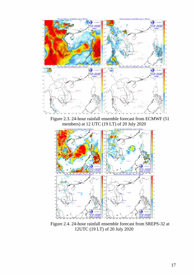
17
Figure 2.3. 24-hour rainfall ensemble forecast from ECMWF (51
members) at 12 UTC (19 LT) of 20 July 2020
Figure 2.4. 24-hour rainfall ensemble forecast from SREPS-32 at
12UTC (19 LT) of 20 July 2020

18
Figure 2.5. 24-hour Observation rainfall at 12 UTC (19 LT) of 21 July 2020
Identified opportunities/challenges, if any, for further development
or collaboration:
VNMHA is providing the SREP-32 products on SWFDP-SeA website
for member countries to use in daily severe weather forecast and warning.
Feedbacks and suggestions from members are welcome for a better
information design and delivery.
Priority Areas Addressed:
KRA 1: To mitigate against the damaging impacts of typhoons and
enhance the beneficial typhoon related effects for the betterment of quality of
life through scientific research, technological development and operational
enhancement.
KRA 4: To enhance capacity to generate and provide accurate, timely
and understandable information on typhoon-related threats
Contact Information:
Member: Social Republic of Vietnam
Name of contact for this item: Dr. Du Duc Tien
Telephone: +84936067015
Email: [email protected]


![Road Improvement Project in the Socialist Republic of Viet Nam (Loan 1272-VIE[SF])](https://static.fdocuments.net/doc/165x107/577ce6d91a28abf10393be3d/road-improvement-project-in-the-socialist-republic-of-viet-nam-loan-1272-viesf.jpg)