SOCIAL & ENVIRONMENTAL IMPACT ASSESSMENT (SEIA) EXECUTIVE SUMMARY · · 2011-03-03Executive...
22
Executive Summary Bisha Project, Eritrea December 2009 J206/BMSC/SEIA 2009/FINAL Page 1 SOCIAL & ENVIRONMENTAL IMPACT ASSESSMENT (SEIA) EXECUTIVE SUMMARY For the Bisha Mine Project Submitted to: Ministry of Energy and Mines Asmara, Eritrea Submitted by: Bisha Mining SC Eritrea February 2010
Transcript of SOCIAL & ENVIRONMENTAL IMPACT ASSESSMENT (SEIA) EXECUTIVE SUMMARY · · 2011-03-03Executive...

Executive Summary Bisha Project, Eritrea December 2009
J206/BMSC/SEIA 2009/FINAL Page 1
SOCIAL & ENVIRONMENTAL IMPACT ASSESSMENT (SEIA)
EXECUTIVE SUMMARY
For the Bisha Mine Project
Submitted to:
Ministry of Energy and Mines
Asmara, Eritrea
Submitted by:
Bisha Mining SC
Eritrea
February 2010

Executive Summary Bisha Project, Eritrea December 2009
J206/BMSC/SEIA 2009/FINAL Page 2
SOCIAL AND ENVIRONMENTAL IMPACT ASSESSMENT EXECUTIVE SUMMARY
TRACKING SHEET
DATE CHANGES NAME
21 Jan 2010 Updates to the SEIA to reflect the current design and approach Citrus Partners LLP
04 Feb 2010 Internal Review Citrus Partners LLP
17 Feb 2010 Internal Review BMSC

Executive Summary Bisha Project, Eritrea December 2009
J206/BMSC/SEIA 2009/FINAL Page 3
TABLE OF CONTENTS
Page
1.0 INTRODUCTION ................................................................................................................................6
2.0 ERITREAN APPROVALS PROCESS ...............................................................................................6
3.0 THE PROJECT...................................................................................................................................7
3.1 PROJECT LOCATION ..........................................................................................................................7 3.2 PROJECT PROPONENT.......................................................................................................................8 3.3 PROJECT DESCRIPTION .....................................................................................................................8 3.4 CONSTRUCTION SCHEDULE ...............................................................................................................8 3.5 ON & OFF-SITE FACILITIES ................................................................................................................8
3.5.1 Accommodation .......................................................................................................................8 3.5.2 Wastewater Treatment Plant ...................................................................................................8 3.5.3 Power Supply...........................................................................................................................8 3.5.4 Water Supply ...........................................................................................................................9 3.5.5 Airstrip......................................................................................................................................9
4.0 DESIGN ENGINEERING AND SEIA PROCESS...............................................................................9
4.1 TAILINGS MANAGEMENT FACILITY (TMF)..........................................................................................10 4.2 WASTE ROCK FACILITIES (WRFS)....................................................................................................11 4.3 WATER DIVERSION SYSTEM.............................................................................................................12 4.4 TRANSPORT ROUTES.......................................................................................................................13
5.0 ENVIRONMENTAL IMPACT ASSESSMENT .................................................................................14
5.1 AIR QUALITY ...................................................................................................................................14 5.2 NOISE & VIBRATION.........................................................................................................................14 5.3 ACID ROCK DRAINAGE.....................................................................................................................14 5.4 SEISMICITY .....................................................................................................................................15 5.5 SURFACE WATER IMPACTS ..............................................................................................................15
5.5.1 Hydrological Setting...............................................................................................................15 5.5.2 Impact Assessment & Mitigation............................................................................................15
5.6 GROUNDWATER IMPACTS.................................................................................................................16 5.6.1 Ground Water Quality ............................................................................................................16 5.6.2 Regional Groundwater Flow & Recharge ..............................................................................16 5.6.3 Other Groundwater Users......................................................................................................16 5.6.4 Impact Assessment & Mitigation............................................................................................16
6.0 SOCIAL IMPACT ASSESSMENT ...................................................................................................17
6.1 ECONOMIC IMPACTS ........................................................................................................................17 6.2 IMPROVED INFRASTRUCTURE ...........................................................................................................17 6.3 EMPLOYMENT OPPORTUNITIES.........................................................................................................18 6.4 POPULATION & MIGRATION FLUX IMPACTS........................................................................................19 6.5 SOCIAL ADJUSTMENT ......................................................................................................................19 6.6 COMMUNITY AND PUBLIC HEALTH ....................................................................................................20 6.7 ARCHAEOLOGY & CULTURAL HERITAGE ...........................................................................................20 6.8 LAND USE IMPACTS .........................................................................................................................20 6.9 COMMUNITY ASSISTANCE PLAN (CAP).............................................................................................21 6.10 FUTURE SEIA FOR THE TRANSPORT ROUTE CORRIDOR AND PORT FACILITY......................................21
7.0 SOCIAL AND ENVIRONMENTAL MANAGEMENT .......................................................................22
Executive Summary Bisha Project, Eritrea December 2009
J206/BMSC/SEIA 2009/FINAL Page 4
LIST OF FIGURES
Figure 3.1: Map of Eritrea Indicating the Project Location ............................................................................7 Figure 4.1: Proposed Pit Design and Project Layout (TMF, WRFs, Processing Mill,
Construction Camp)...........................................................................................................10 Figure 4.2: Road Options from Massawa to Bisha......................................................................................13

Executive Summary Bisha Project, Eritrea December 2009
J206/BMSC/SEIA 2009/FINAL Page 5
PROJECT FACT SHEET
GOVERNING BODY: The Government of the State of Eritrea, represented by the Minister of Energy and Mines
JURISDICTION: Eritrea
PROJECT NAME: Bisha Project
PROJECT PROPONENT:
Bisha Mining Share Company (BMSC), a company incorporated in Eritrea having a registered office address at, Mariam Gimby Street, #61, Asmara, Eritrea.
OWNERSHIP: 60% Nevsun; 40% ENAMCO
PROJECT LOCATION: Gash Barka Zoba, 150 km west of Asmara
PROJECT AREA: Mining License area of 16.5 km2
granted in 2008 (16 May 2007)
Current Exploration license area of 94.5 km2
granted in 2008 (16 October 2008)
TYPE OF MINING: Conventional open pit, front-shovel-truck
MINE LIFE: Minimum of 10 years+
MINERAL DEPOSIT: Large, precious metal and base metal-rich volcanogenic massive sulphide (VMS) deposit
RESERVE: Undiluted proven and probably reserve 20.08 million tonnes
PERSONNEL: 350 during construction to 168 during initial operations. Maximum will be 700 in year 7 as production increases. HR & Recruitment Policy requires local employment first and as far as practicable.
OPERATIONS: 350 days per year; 3 shifts of 8 hours (24 hrs)
PRODUCTION RATE: 2,000,000 Mtpa of ore; total of 21,897,000 tonnes over 10 years.
STRIP RATIO: 4.7:1
TOTAL MINE WASTE: 93,618,000 tonnes of waste; The waste material will be disposed in two areas, one to the north of the pit, named the North Dump and other to the south of the pit, named the South Dump.
PIT CONFIGURATION: The open pit is expected to be nominally 1.4 km long and 550 m wide consisting of two coalescing pits, a shallow pit to the north and a much deeper pit to the South
PROCESSING: Phase 1: Oxide ore will be processed by cyanide leaching using a conventional CIL plant which will operate for at least the first two years of production life.
Phase 2: Comprises a separate copper flotation circuit constructed to process the sulphide supergene Ore to produce copper concentrate.
Phase 3: Comprises a second flotation circuit constructed to process the primary ores respectively to produce both copper and zinc flotation concentrates.
CONSTRUCTION/MINE START UP:
Development has commenced; start-up planned for July 2010
PRE-PRODUCTION CAPITAL COST:
US$250 million (including working capital and financing costs)
SEIA: Completed 2006; approved Impact Review Committee 2008; updated SEIA submitted February 2010.
Executive Summary Bisha Project, Eritrea December 2009
J206/BMSC/SEIA 2009/FINAL Page 6
1.0 INTRODUCTION
Bisha Mining SC (“BMSC”), an Eritrean registered company, is applying for a mining license from the
Ministry of Energy and Mines to construct and operate an open pit gold, copper and zinc mine (known as
“Bisha” or the “Project”). The proposed mine will operate for a minimum period of ten years and
construction is scheduled to commence in 2009, following approval by the Ministry and confirmation of
funding sources. This document provides a summary of the Social and Environmental Impact
Assessment (SEIA) for the Bisha mine. The full SEIA is available under separate cover.
The methodology employed in the preparation of this Social and Environmental Impact Assessment
(SEIA) was guided by the State of Eritrea Ministry of Land and Water, Department of the Environment,
National Environmental Assessment Procedures and Guidelines (1999), the approved Terms of
Reference (March 2006) and the approved Public Consultation and Disclosure Plan (March 2006).
2.0 ERITREAN APPROVALS PROCESS
The “National Environmental Assessment Procedures and Guidelines, March 1999” (NEAPG) outline
Eritrean requirements for social and environmental assessment and include Terms of Reference (ToRs),
a Social and Environmental Impact Assessment (SEIA) and the Social and Environmental Management
Plan (EMP). SEIA is the responsibility of the Department of Environment (DoE) of the Ministry of Land,
Water and Environment.
The procedures outline six main stages in the SEIA process comprising:
• Project Screening;
• Preparation of ToRs;
• Implementation of the SEIA and development of the Environmental Management Plan (EMP);
• Review of the Application (SEIA/EMP);
• Project Approval; and
• Monitoring and Evaluation.
In accordance with Eritrean legal requirements and the requirements of the Equator Principles, the
Project has undergone screening and categorisation. Based on a precautionary approach, the Project
was classified as a Category A project for a number of reasons:
• This is the first project on such a scale within Eritrea and will be a major regional employer;
• The Project will lead to permanent changes to the landscape and some permanent diversion of watercourses; and
• A range of social and environmental impacts, both positive and negative, will be created by the Project.
For Category A projects, a full Social and Environmental Assessment (‘Assessment’) process is
obligatory. Preparation of this SEIA commenced in 2004 with the initiation of environmental and social
baseline investigations. Early works also included a comprehensive Public Consultation and Disclosure
Plan (PCDP) which demonstrated a strong public interest for the Project.
The ToR and PCDP were submitted to the Eritrean government in February 2006. An approved ToR for
the Project was received by BMSC in March 2006. The SEIA study was submitted to the Ministry of
Energy and Mines in December 2006. The SEIA was prepared on behalf of BMSC by AMEC Americas of
Vancouver Canada, supported by Global Resources Development and Management Consultants from
Asmara. Since 2006, Citrus Partners LLP have been engaged to work with BMSC on the implementation
of the SEIA and the further development of the EMP into workable management plans.
Specifically, a new Stakeholder Engagement Plan (SEP) to replace the previous PCDP has been
developed which is included in the new Environmental Management Plan for the Project. Some

Executive Summary Bisha Project, Eritrea December 2009
J206/BMSC/SEIA 2009/FINAL Page 7
investigations are also ongoing and will continue throughout the construction, operation and closure
phases of the mine.
A Mining License was granted to BMSC in May 2008, one condition of which was the approval of the
SEIA. Although the SEIA provides all current available baseline data, further refinements to this
document will be submitted in addendum format as the results of ongoing investigations become
available and as the Project moves through construction, operations and closure. Some of these
refinements will be needed to achieve the relevant standards for project financing.
In 2009 and early 2010, the SEIA study has been updated to reflect the environmental and social
improvements to the Project design. The Project EMP has also been updated to reflect the start of the
construction programme and the increasing focus on environmental issues.
BMSC has selected SENET of South Africa as its engineering, procurement and construction
management (EPCM) Contractor. SENET is a highly-experienced engineering and construction
contractor with a long track record in minerals and mining projects in Africa. The SEIA refers to an
application for an open pit gold, copper and zinc mine with a minimum mine life of 10 years and pre-
construction schedule which commenced in 2008.
3.0 THE PROJECT
3.1 Project Location
The Bisha property is located approximately 150 km to the west of Asmara and 43 km southwest of
Agordat (shown as ‘Akurdet’ on Figure 3.1). There is a good quality, paved highway between Asmara
and Agordat after which 43 km of un-paved, compacted gravel links Agordat to the Project area. Figure
3.1 below illustrates the location of the Bisha mining property within Eritrea.
Figure 3.1: Map of Eritrea Indicating the Project Location
Bisha Main Deposit

Executive Summary Bisha Project, Eritrea December 2009
J206/BMSC/SEIA 2009/FINAL Page 8
3.2 Project Proponent
The project proponent is BMSC, an Eritrean-registered company. BMSC is jointly-owned by Nevsun
Resources Ltd (‘Nevsun’) of Vancouver Canada, which holds a 60% interest, and the Eritrean National
Mining Corporation (‘ENAMCO’) which holds the remaining 40%. Nevsun is a Canadian TSX and AMEX
publically-listed company, formed in 1965 for the purpose of acquiring and developing advanced-staged
mineral deposits.
3.3 Project Description
BMSC first acquired the Bisha property in 1998 and a full Mining License was granted on 26th May 2008.
Mining will be via conventional open pit, excavation, truck and shovel operations. The open pit is
expected to be nominally 1.4 km long and 550 m wide consisting of two coalescing pits, a shallow pit to
the north and a much deeper pit to the South.
Oxide ore will be processed by cyanide leaching using a conventional CIL plant which will operate for at
least the first two years of production life. This constitutes ‘Phase 1’ development. Thereafter, and as
Phases 2 and later 3 commence, separate copper and zinc standard flotation circuits will be constructed
to process the sulphide supergene and primary ores to produce both copper and zinc flotation
concentrates.
The crushing, grinding and tailing systems will be common for the three phases. All of the facilities
required to process oxide ore will be installed prior to the commencement of production. This will include
the primary crusher, the semi-autogenous grind (SAG) and ball grinding mills, the tailings thickener; the
tailings discharge system and the necessary reagent, water and air systems and power station.
3.4 Construction Schedule
Current activities on site comprise final construction of the accommodation camp, plant site earthworks
and roads. The civil contract for construction of the CIL and thickener bases has also been awarded.
The earthworks and civil works are being carried out using a local contractor; the planned steelwork
erection, piping, electrical and instrumentation work will be carried out directly by SENET employing a mix
of local and expatriate labour. To this end a training programme has been instigated to select suitable
Eritrean trade’s people and bring their skills up to the standard required; this will be supplemented by
expatriate trade’s people and expatriate management and supervision only on an as required basis.
Plant operation is due to commence in early Q3 2010.
3.5 On & Off-Site Facilities
3.5.1 Accommodation
A permanent camp complex is located approximately 1 km to the north west of the plant site. The camp
has been constructed to local standards including concrete block work walls and is founded on spread
footings. The camp includes all electrical, communication, lighting, mechanical, sprinklers, plumbing
equipment and fixtures, all finishes, furniture and related items.
The camp houses approximately 300 people and includes dormitories, kitchen and dining facilities,
recreation facilities, laundry, water treatment, sewage treatment and emergency power facilities.
3.5.2 Wastewater Treatment Plant
A wastewater treatment plant (WWTP) has been constructed at the permanent camp. The treated effluent
is discharged to a temporary lagoon for evaporation during construction; during operations treated
wastewater will be diverted to the processing plant subject to the attainment of applicable quality
standards.
3.5.3 Power Supply
The mine and processing plant site will be supplied with electrical power generated from a new power
station located adjacent to the grinding plant. Peak power requirements (excluding power station loads)

Executive Summary Bisha Project, Eritrea December 2009
J206/BMSC/SEIA 2009/FINAL Page 9
for the mine, processing plant and ancillary buildings vary with processing phase from around 15.2 MW to
19.1 MW. The port concentrate load-out facility near Massawa will receive power from the local utility.
The power generation station may use either distillate diesel or Heavy Fuel Oil (HFO) depending on
availability, environmental and cost factors. Options and potential environmental impacts of the different
fuel alternatives have been reassessed under the new air quality impact assessment (the 2006 dispersion
model was updated in 2009).
3.5.4 Water Supply
Water supply will be almost exclusively from groundwater. Groundwater will be supplied from a principal
well-field located along the Mogoraib River and from a secondary dewatering well-field installed across
the Freketetet River, which is a tributary of the Mogoraib River, and one of the main rivers running south-
north in the Project area (other rivers include the Shatera and Mogoraib).
The required project water demand is estimated to be equivalent to approximately 7% of the usable
groundwater resource in the Mogoraib River Basin and is not expected to have a significant impact on
existing water use or on future water development in the area.
Well testing has demonstrated that the 10 most productive boreholes in the Mogoraib well-field have a
combined yield of 127.5 l/sec, while it is estimated that the dewatering well-field across the Freketetet
River could provide a minimum of 25 l/sec under conditions of concurrent pumping. Thus these two well-
fields have a potential yield of 153 l/sec; i.e. significantly higher than the project water demand of (73 l/sec
or 263 m3/hour).
Potable water will be treated with filtration, chlorination and ultraviolet treatment.
The process plant will consume the largest amount of the water. The process has been designed to
maximize the recycling of process water and includes the installation of a tailings slurry thickener to
recover process water prior to pumping to the tailings containment system. This approach serves to
minimize the evaporation losses that result with the typically large water surface area in tailings
containment systems. As a consequence of the high evaporation rates it is projected that insufficient
decant water will be available in the tailings containment to warrant a reclaim pumping system.
3.5.5 Airstrip
Construction of an airstrip was completed in 2006, by the Government of Eritrea, to the north of the Bisha
deposit.
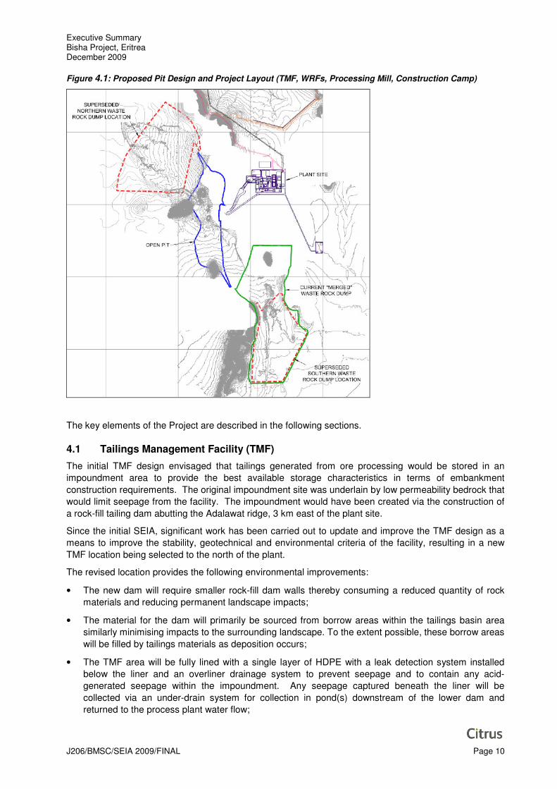
4.0 DESIGN ENGINEERING AND SEIA PROCESS
The layout of the Project has been developed to minimise the Project’s social and environmental impact,
comply with new legislation and best practice standards; and maximise operational efficiency. Figure 4.1
below illustrates the project layout including the Waste Rock Facilities (WRFs), Tailings Management
Facility (TMF), pit and processing plant.
Executive Summary Bisha Project, Eritrea December 2009
J206/BMSC/SEIA 2009/FINAL Page 10
Figure 4.1: Proposed Pit Design and Project Layout (TMF, WRFs, Processing Mill, Construction Camp)
The key elements of the Project are described in the following sections.
4.1 Tailings Management Facility (TMF)
The initial TMF design envisaged that tailings generated from ore processing would be stored in an
impoundment area to provide the best available storage characteristics in terms of embankment
construction requirements. The original impoundment site was underlain by low permeability bedrock that
would limit seepage from the facility. The impoundment would have been created via the construction of
a rock-fill tailing dam abutting the Adalawat ridge, 3 km east of the plant site.
Since the initial SEIA, significant work has been carried out to update and improve the TMF design as a
means to improve the stability, geotechnical and environmental criteria of the facility, resulting in a new
TMF location being selected to the north of the plant.
The revised location provides the following environmental improvements:
• The new dam will require smaller rock-fill dam walls thereby consuming a reduced quantity of rock
materials and reducing permanent landscape impacts;
• The material for the dam will primarily be sourced from borrow areas within the tailings basin area
similarly minimising impacts to the surrounding landscape. To the extent possible, these borrow areas
will be filled by tailings materials as deposition occurs;
• The TMF area will be fully lined with a single layer of HDPE with a leak detection system installed
below the liner and an overliner drainage system to prevent seepage and to contain any acid-
generated seepage within the impoundment. Any seepage captured beneath the liner will be
collected via an under-drain system for collection in pond(s) downstream of the lower dam and
returned to the process plant water flow;

Executive Summary Bisha Project, Eritrea December 2009
J206/BMSC/SEIA 2009/FINAL Page 11
• The tailings will be thickened at the mill to a maximum of 50% solids, to reclaim as much water as
possible prior to transport to the tailings (and to limit wastewater discharge);
• Any cyanide used in the mineral processing will be destroyed, in accordance with international norms,
prior to pumping to the tailings impoundment;
• An over liner drainage system will lead to improved consolidation of the final tails to improve the
characteristics of the tailings at closure and under a seismic event;
• The facility has been designed and will be operated to maintain the supernatant pond in the middle of
the facility and therefore away from the dams minimising risks in the event of seismic events; and
• Closure of the TMF will be simplified and the closed facility will have an acceptable final land form
with surface configuration, topsoil coverage and planting as appropriate to the location.
The revised location of the tailing management facility (‘TMF’) is approximately 1 km to the north of the
process plant location (see Figure 4.2). The TMF will be located in an alluvial plain bounded by steep
hills and ridges to the north-east and south-west. The area is covered by limited and sparse vegetation.
The impoundment will be created through the construction of lined earth-filled tailings embankments with
the addition of smaller saddle dams at the perimeter a later stage of development.
Figure 4.2: New TMF Location and Layout
4.2 Waste Rock Facilities (WRFs)
The original mine design envisaged a large contiguous waste dump extending to the west of the open pit.
This design presented drainage management challenges in relation to the prevention of potential acid
water contamination of the nearby Mogoraib River. Following further evaluation, the waste dump
configuration has been altered to eliminate the western dump and instead provide a north and south
Executive Summary Bisha Project, Eritrea December 2009
J206/BMSC/SEIA 2009/FINAL Page 12
dump, which are positioned to actively drain any resultant flows into the pit. The key environmental
benefits of the new configuration are described below:
• The removal of ARD issues associated with the west dump on this westward down-sloping side;
• Optimised haulage distances;
• Minimising the overall surface area to optimise closure requirements and improve final landforms;
• The facilities will be designed so that discharge from the WRFs can be collected and used for mill
water supply, and/or routed to the open pit; both of which will serve to conserve water resources;
• Both the ditches and the ponds will be lined with a suitable impermeable geosynthetic material;
• During operations, waste rock will be placed in 10 m lifts within the facilities and re-contoured as
accessible to no greater than a 3:1 slope to enhance facility stability and decrease re-grading during
facility reclamation;
• Most of the waste to be generated from the development of the Bisha Project is expected to be
potentially acid-generating (PAG). To this end, the facilities will be lined with a low permeability soil
and under-drains will be installed to collect any discharge;
• Elimination of the western dump also gives flexibility in exploring the potential ore deposit in the
western wall of the pit; and
• Access to additional ore in the northern pit which was not accessible in the original 2006 design but
now becomes available.
An estimated 93.6 Mt of waste rock will be produced over the mine life.
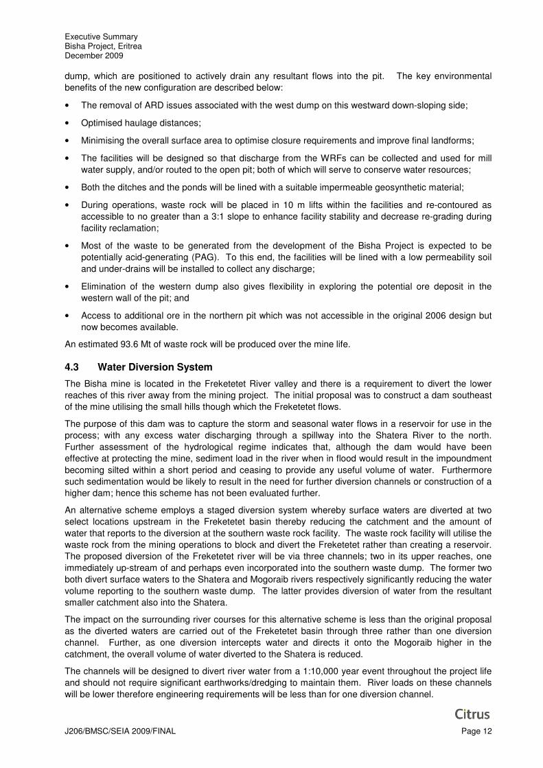
4.3 Water Diversion System
The Bisha mine is located in the Freketetet River valley and there is a requirement to divert the lower
reaches of this river away from the mining project. The initial proposal was to construct a dam southeast
of the mine utilising the small hills though which the Freketetet flows.
The purpose of this dam was to capture the storm and seasonal water flows in a reservoir for use in the
process; with any excess water discharging through a spillway into the Shatera River to the north.
Further assessment of the hydrological regime indicates that, although the dam would have been
effective at protecting the mine, sediment load in the river when in flood would result in the impoundment
becoming silted within a short period and ceasing to provide any useful volume of water. Furthermore
such sedimentation would be likely to result in the need for further diversion channels or construction of a
higher dam; hence this scheme has not been evaluated further.
An alternative scheme employs a staged diversion system whereby surface waters are diverted at two
select locations upstream in the Freketetet basin thereby reducing the catchment and the amount of
water that reports to the diversion at the southern waste rock facility. The waste rock facility will utilise the
waste rock from the mining operations to block and divert the Freketetet rather than creating a reservoir.
The proposed diversion of the Freketetet river will be via three channels; two in its upper reaches, one
immediately up-stream of and perhaps even incorporated into the southern waste dump. The former two
both divert surface waters to the Shatera and Mogoraib rivers respectively significantly reducing the water
volume reporting to the southern waste dump. The latter provides diversion of water from the resultant
smaller catchment also into the Shatera.
The impact on the surrounding river courses for this alternative scheme is less than the original proposal
as the diverted waters are carried out of the Freketetet basin through three rather than one diversion
channel. Further, as one diversion intercepts water and directs it onto the Mogoraib higher in the
catchment, the overall volume of water diverted to the Shatera is reduced.
The channels will be designed to divert river water from a 1:10,000 year event throughout the project life
and should not require significant earthworks/dredging to maintain them. River loads on these channels
will be lower therefore engineering requirements will be less than for one diversion channel.

Executive Summary Bisha Project, Eritrea December 2009
J206/BMSC/SEIA 2009/FINAL Page 13
4.4 Transport Routes
A survey of road transport options was conducted by Bertling Global Project Logistics. This survey
included a full assessment of the road conditions (surface, infrastructure, flood and inundation risk) of two
principal routing options. The ‘northern route’, passing through Afabet, was found to have poor road
conditions for a significant portion in addition to a number of geomorphological hazards and 200km of
unpaved road. The ‘southern route’ is 54 km shorter with a significantly shorter stretch of unpaved road
(49km). Figure 4.2 illustrates the northern and southern (base case route) route options.
For the purposes of constructing Phase 1 of the Project the southern route will be used. Construction of
the Project requires that certain large and/or heavy loads will need to be transported to the site, given the
limitations on the southern route the larger of these loads will be brought through Sudan.
During Phase 1 operation approximately 5 to 8 truck movements per day will also be required for general
mine supplies.
Figure 4.2: Road Options from Massawa to Bisha
In addition, but separate to the requirements for the Project, the Government of Eritrea (Ministry of Public
Works (MoPW) is planning to rehabilitate the road from Asmara to Bisha. Engineering and planning work
has been undertaken and construction works are expected to commence in 2010. Citrus, together with
GRC are currently undertaking a Transport Assessment (TA) of the southern route. Terms of Reference
for the TA have been prepared and will be subject to IRC for agreement.
The following two sections summarise the results of the SEIA (from 2006 and subsequent work).

Executive Summary Bisha Project, Eritrea December 2009
J206/BMSC/SEIA 2009/FINAL Page 14
5.0 ENVIRONMENTAL IMPACT ASSESSMENT
5.1 Air Quality
Ambient air quality measurements were taken at Bisha between April 2006 and October 2006.
Remodelling of air emissions was also undertaken in 2009 to reflect the updated Project design, and thus
potential point source and fugitive emissions.
Existing sources of air emissions are limited to vehicular traffic, wild fires, dust storms and fuel burning at
local villages and settlements. Of these sources, dust storms are considered to be the most significant in
the context of dust. In the dry season (October to June) sandstorms are common at certain periods. The
‘Kamsin’ sandstorms blow from Sudan and carry fine clay and sand particles. Furthermore air quality can
also be impacted by grass fires set by local farmers. The low population density indicates the impact
from domestic fuel burning is minor. There are no industrial sources of air emissions within the Project
area.
When comparing the measured baseline concentrations with the various ambient standards the following
conclusions can be made:
• Concentrations of NOx and SO2 (which are typically associated with industry or vehicle exhaust
emissions) are substantially less than the respective annual average standards; and
• PM10 concentrations are elevated when compared to their respective standards (although this is
likely to be due to windblown dust rather than manmade sources).
Potential impacts to air quality associated with the operation of the Project are as follows:
• Combustion emissions from power generation and the carbon regeneration kiln; and
• Episodic dust from mining activities.
In the absence of nearby receptors, none of these impacts are expected to be significant and an Air
Quality Management Plan has been produced which describes the mitigation measures to be taken by
the Environment Department of BMSC.
5.2 Noise & Vibration
Continuous, 24-hour surveys of baseline noise were completed in July 2006 and repeated one month
later at the proposed Bisha plant site and accommodation area. Further monitoring has been undertaken
on a periodic basis and is now ongoing, bi-annually.
In the absence of national noise limits the Project has elected to apply WB/WHO noise guidelines as
Project targets. Baseline measurements indicated relatively low existing noise levels (between 30 and 40
dBA), typical for a sparsely populated area. The principal noise sources observed during measurement
periods were distant power generators, trucks, wildlife, livestock and playing children.
Noise within the mine areas will arise from blasting events and operation of large excavators and haulage
trucks. Noisy items of equipment within the ore processing facility will include power generating engines,
cooling fans, ore crushers and grinders, pumps, heater exhausts, compressors and plant motors.
Mining and processing of ore will take place 24-hours per day, in a variety of locations. Blasting is
expected to take place between the hours of 0900 and 1700 only.
The screening data indicate that impact (nuisance) to the closest sensitive receptor, the worker camp, is
unlikely. Mining and ore processing operations are not expected to cause significant nuisance to the
camp and local communities. A Noise Management Plan has been produced to ensure that the Project
employs best practice for noise attenuation.
5.3 Acid Rock Drainage
A number of the rock layers that will be mined have the potential to produce acidic drainage. While the
oxide cap may contain some non acid generating (NAG) material, the supergene and primary ore is

Executive Summary Bisha Project, Eritrea December 2009
J206/BMSC/SEIA 2009/FINAL Page 15
considered to be potentially acid generating (PAG). As much of the waste rock poses a risk of acid
generation, the TMF and WRFs have been designed to minimise the risk of acid leaching by collecting
and treating runoff and seepage waters. A Waste Rock Management Plan has been produced and will
be updated as the detailed design of the WRFs is completed.
5.4 Seismicity
Seismic risk assessment has been conducted by Amec Earth & Environmental UK Ltd in relation to the
design of the new TMF. Eritrea is situated within the Eastern and Southern African region which is prone
to a significant level of seismic hazard due to the presence of the East African Rift System.
The proposed mine site lies within 200 km of the major rift valley faults in an area which shows no seismic
activity and the seismic risk has been classified as the lowest category and no significant impacts are
expected.
5.5 Surface Water Impacts
The baseline quality of the surface water in the watersheds of the Project area has been assessed in
detail in the project SEIA prepared in 2006 and through the ongoing water quality monitoring programme.
These studies included the Mogoraib River located 2 km to the west of the Project, its Freketetet River
tributary, the Shatera River and the Awhe River.
5.5.1 Hydrological Setting
The Project area lies in the Barka River basin which flows northwards into Sudan and ultimately
discharges into the Red Sea and is one of Eritrea’s two major drainage basins. The second, which lies to
the south and is not impacted by the Project, is the Gash River system and is a tributary of the Nile.
Several intermittent streams flow northwards through the area into the Barka River, including the
Mogoraib River. The Freketetet River, a smaller tributary to the Mogoraib, flows north-westwards across
the planned open pit; as described above, a series of diversion channels will be constructed upstream to
divert water eastwards into the northward-draining Shatera River basin and westwards into the Tabakin
River system.
The surface water flow in the area is characterised by flash floods channelled along the rivers or, outside
of the rivers areas, as sheet flow. The flow in the main rivers is intermittent and only occurs during the
rainy season.
5.5.2 Impact Assessment & Mitigation
The potential impacts of the Project on surface water will be due to the diversion of local water courses,
run-off from the mine and waste areas, and run-off from the tailings area. The mine, waste areas and the
tailings area will be designed to be have minimal discharge, with any water leaching from or running-off
them being captured and returned to the TMF or processing plant as appropriate.
The most significant surface water diversion is of the headwaters of the Freketetet River into the Shatera.
The water quality assessment shows that the headwaters of the Freketetet River and Shatera River are
very similar (which is to be expected as their catchments are similar in characteristics). Therefore there
are unlikely to be any significant impacts on water quality on the Shatera due to the diversion, other than
an increase in flow volumes and some turbidity resulting in a higher suspended load.
The increase in sediment/turbidity created in the Shatera as a consequence of the diversion could result
in more rapid channel movement, which together with the higher levels could lead to increased flood
levels and sediment movements along the river system. These are most likely to be more prominent in
the upper and middle reaches of the Shatera, and the impacts will have declined in the lower reaches of
the river and therefore unlikely to have any significant impact on agricultural land or communities in these
lower reaches. Further hydrological assessment of the Shatera has been commissioned by BMSC.
Executive Summary Bisha Project, Eritrea December 2009
J206/BMSC/SEIA 2009/FINAL Page 16
5.6 Groundwater Impacts
Hydrogeological studies for the Project have been undertaken in a number of phases starting in 2003 with
the last phase being the installation of the array of dewatering wells across the Freketetet River up
gradient of the main pit. Data on water levels has been collected from the 2004 monitoring network
through to the present, either manually or through the use of loggers.
5.6.1 Ground Water Quality
Groundwater samples have been collected from exploration boreholes and monitoring wells during the
various groundwater exploration phases, and analysed at accredited laboratories in Canada and Asmara.
The concentrations of all chemical species in all the samples are substantially below their respective
WHO maximum permissible limits (MPLs) and groundwater is considered suitable for use as potable
water. The bacteriological analysis however detected varying faecal coliform counts in all but three of the
samples. These results indicate that groundwater in the Mogoraib Basin has undergone varying levels of
organic contamination from grazing animals, and water drawn from most locations within the well field
may be unsafe for human consumption unless first treated. This issue can be easily treated in the site’s
water supply system and is not considered a significant issue. Groundwater is already treated on-site
through a UV system.
5.6.2 Regional Groundwater Flow & Recharge
Groundwater flows primarily through alluvial deposits and fracture zones within the bedrock. Recharge to
the aquifers are understood to be from infiltration across the catchment of the Mogoraib as far as the
higher Gash River system to the south; this infiltrated water then flows through the alluvial and bedrock
aquifers northwards into the Barka River.
As a result, any changes in flow rate along the Gash River due to human activity (over abstraction,
damming) or other factors such as climate change are unlikely to affect the Project as such reductions in
recharge would not be anticipated to result in a decrease in the local water level at the Project wells within
the life time of the Project.
5.6.3 Other Groundwater Users
Groundwater is the primary source of domestic water in the area and is typically obtained from boreholes
into the bedrock aquifer, together with shallow hand dug wells or boreholes in the alluvium, such as those
along the Mogoraib River. These wells provide a perennial source of water for the local users. The
nearest well in the area in regular use is that supplying Mogoraib village; many of the other wells within
the mine environs appear to be used only casually, if at all.
There are also 121 banana plantations between Agordat and Mogoraib village. Details on some of these
at Tekreret and near Mogoraib were obtained and indicate fairly substantial groundwater use. There are
a number of lime plants in Ad Ibrihim and the amount of water use is unknown. A brick factory in Tekreret
uses very little water. The distance of these other users from the Project means that the Project’s water
demands will not influence other groundwater users in the area.
5.6.4 Impact Assessment & Mitigation
Groundwater withdrawals and pit seepage will result in a lowering of the hydrostatic head within the
fractured bedrock in the immediate vicinity of the pit. The low conductivities measured in the bedrock
mean that there are unlikely to be any impacts on other groundwater users in the area. Given that the
fractured bedrock aquifer is extensive in range and is inferred to extend beyond the Mogoraib basin, the
impact of the mining operations on regional groundwater will be limited and is not considered significant.
Once mining has concluded, the pit will fill with water over time until equilibrium is reached between inflow
(surface water runoff and groundwater seepage) and outflow (evaporation). Due to the high evaporation
rates, which substantially exceed precipitation, it is expected that the water level within the pit will stabilize
at a level below the static groundwater level in the area. This will result in a groundwater sink, i.e., that
there will be a continuous groundwater gradient towards the pit and hydraulic head outside the pit will be

Executive Summary Bisha Project, Eritrea December 2009
J206/BMSC/SEIA 2009/FINAL Page 17
depressed. The resultant drawdown cone around the pit is expected to have a local impact on
groundwater levels in the areas and therefore its local resource potential.
6.0 SOCIAL IMPACT ASSESSMENT
6.1 Economic Impacts
The direct revenue stream from the Project is expected to materially improve the GDP of Eritrea. Direct
revenue flows from the Bisha development to the government during operations are estimated to total in
excess of US$275 million, including income tax, royalties and other charges. The export of semi-
processed minerals will change the country’s trade balance; Eritrea’s export to import ratio is forecast to
grow from 7% (without Bisha) to up to 18% (with Bisha) by 2018.
At full operations, the Bisha project will employ approximately 700 staff, which, using a conservative
multiplier of 3.5 will result in 2,450 job opportunities. There will also be an increase in local and regional
business opportunities and an increase in the buying power of employees, which has proven a stimulate
in other locales in which significant projects have been developed.
BMSC is committed to enhancing these effects by sourcing goods and services from national and local
suppliers where possible. The Bisha mine is set in a rural economy and without careful management
could cause some economic dislocations including localised inflation. BMSC has established its wage
levels (and that of main contractors) with consideration for the regional and national labour market.
BMSC (and its contractors) have established a policy of giving priority to the hiring of Eritrean nationals.
Direct jobs during construction and operations are clearly advertised and preference is given to local
employment. Where a paucity of skills exists BMSC provides vocational training and a number of training
facilities are under development at the permanent camp and in the nearest community - Mogoraib.
Despite the emphasis on local employment, some expatriate specialists are still required to perform a
number of specific skills which are not currently available in country. The aim of these appointments is to
train local personnel to replace the expatriates and achieve a final steady state.
A further potential positive effect of mine development is improved quality of life for some mine workers
and their families, including those from the local area. This positive effect can occur when mine income is
used for beneficial ends such as better nutrition and health care, home improvements, resources for
farming, education and travel. BMSC will seek to enhance these positive effects by offering employees
support in managing their wages, money management training and other related capacity building
initiatives.
6.2 Improved Infrastructure
Construction of roads and other infrastructure as a result of the Project is expected to have a positive
effect on the local and regional area. Specific infrastructure improvements/upgrades have been identified
and certain already undertaken including:
• an all weather connector road planned between the Bisha mine site and the village of Ad Ibrihim;
• upgrading of road facilities between Bisha and the port of Massawa before production to ensure
concentrate can be effectively transported from site to port (in conjunction with other road
improvement projects such as that of the EU);
• a new power plant will be built by BMSC adjacent to the mine site;
• a health clinic has been built on site for construction and operations and will also have a dedicated
ambulance, and will be available for workers and their families;
• up-grades to the medical facilities at Mogoraib in cooperation with government, so they can be used
to support the mine site clinic and the local population; and,

Executive Summary Bisha Project, Eritrea December 2009
J206/BMSC/SEIA 2009/FINAL Page 18
• several works to upgrade local water supply systems (e.g. wells, piping, diversion channels) through
the Community Assistance Plan (initial funding has been approved by the company for upgrade
works in several communities and an Engineer has been appointed).
Road and other infrastructure upgrades undertaken by BMSC are expected to offset any potential
deterioration in infrastructure quality as a result of Project use, and are anticipated to have an overall net
positive effect on the local (and to some extent regional) area.
6.3 Employment Opportunities
Eritrea currently lacks a modern mining sector, therefore some of the skilled labour force and most of the
Project equipment will be brought into the country from elsewhere. The potential positive effect is
increased wage employment for skilled and semi-skilled Eritrean nationals. The main enhancement
measures that the Project will implement to maximize national/local recruitment include:
• BMSC (and main contractors) will ensure that Eritreans are hired where possible, not expatriates;
• BMSC will also implement a recruitment and employment policy whereby direct jobs during
construction and operations will be clearly advertised and preference will be given to local
employment;
• the Project will proactively communicate job openings through the appropriate local and regional
channels to promote national/local employment as well as avoid speculative migration;
• resources and appropriate facilities will be made available to assist qualified women who wish to
work on the Project (a number of women are already employed in semi-skilled and skilled positions
on site including secretaries, nurses and cooks); and
• the selected workers will undergo construction and mining specific training in order to help them
meet the requirements of the Project (see below).
The use of expatriate specialists will still be required until the necessary skills have been developed to the
level necessary sustain steady state operations.
The topic of local employment has been mentioned frequently during consultation meetings and
expectations are high; however, it is clear that very few local residents currently have the necessary life
skills or work skills to initially access jobs with the mine. The local area is an agricultural-based economy
(rather than market economy), few local residents have a high school education, and illiteracy is high.
The focus of maximizing local recruitment will initially be on:
• the small number of local residents who reported they have experience with operating vehicles and
equipment and certain construction skills;
• providing basic education (e.g. literacy) and training (e.g. driving, cooking etc) to improve job
readiness (for the mine and potentially other local industries); and
• supporting the development of small and medium sized enterprises (SME’s) within local
communities to supply and service the mine, which is expected to create more local employment
opportunities.
Enhancement of employment opportunities and particularly maximization of local recruitment during
construction and operations will be effected through the Human Resources and Employment Plan.
Eritrean workers will be employed and trained during the construction phase, with a view to preparing
some of them for operations.
In readiness for operations, BMSC will also implement a skills training program aimed at training Eritrean
nationals for the mining workforce. Specific training programs will vary depending on the needs of
mining, process plant, maintenance and other departments, but will start early in the construction process
to ensure there is sufficient time for training before operations.
Executive Summary Bisha Project, Eritrea December 2009
J206/BMSC/SEIA 2009/FINAL Page 19
BMSC is also developing a community training program aimed at the five nearby villages (and potentially
the sub-Zoba) to provide basic literacy and skills training for a portion of the local population. The aim of
the community training program is to help local people access some unskilled and semi-skilled positions
with the Project as they obtain the skills required.
6.4 Population & Migration Flux Impacts
During construction and operation the population in the local area and region is expected to grow
including the development of a ‘shadow population’ from migrant workers.
BMSC is committed to providing adequate worker accommodation that meets with the approval of the
Eritrean government and local authorities, and minimizes disruption to nearby villages. As such BMSC is
implementing the following measures:
• a permanent camp complex for 300 non-local workers is being built by the Project for construction
activities (this is nearly complete);
• other non-local workers employed by sub-contracting companies (e.g. Segen, an Eritrean civil
contractor) are and will continue to be housed at separate camps temporarily established adjacent to
the main Bisha camp;
• a limited number of non-local and temporary contractors will be provided an allowance and
supported to find accommodation in nearby villages/towns (e.g. in Mogoraib or Agordat); and
• additional accommodation will be required to cover peak periods of operation and BMSC is
considering both additional on-site housing options as well as the development of nearby villages
(particularly Mogoraib) to house operations (and potentially construction) staff with some fiscal
benefit.
With respect to the influx of migrant job seekers, BMSC is, and will continue to, proactively communicate
in Eritrea including the local and regional areas regarding job openings, required skills and hiring
procedures.
6.5 Social Adjustment
As the Bisha mine is the first mining project in Eritrea, and is located in a rural setting, there are likely to
be some social adjustment issues for Eritrean employees of the mine, as well as for local residents.
Perhaps most importantly, there will be adjustment challenges for the mostly Muslim local residents and
local Project workers following the arrival of Eritrean nationals (many of them Coptic Christians) from
Asmara and the highlands.
While migration in search of wage employment is familiar, many Eritrean employees at Bisha (both
nationals and locals) will not have had experience working under or alongside expatriates in a modern
mining company environment. Increased stresses on households of Eritrean national and local workers
may also arise due to aspects such as mine income. With mine wages likely to be higher than other
wage employment in the local/regional area, issues may arise about dysfunctional spending of mine
income, for example on smoking or alcohol consumption.
The provision of adequate worker accommodation for expatriate and non-local Eritrean nationals will be
the most significant measure to mitigate potential social disruption in the area. BMSC will also require
that all new employees and contractors attend a comprehensive induction that includes a cross-cultural
awareness component. BMSC has also established a Code of Conduct for employees and contractors.
BMSC will work with the local and regional authorities to monitor worker and community interaction in the
area and any particular sources of conflict. Importantly, BMSC will maintain open channels of
communication with its workers and surrounding local communities.

Executive Summary Bisha Project, Eritrea December 2009
J206/BMSC/SEIA 2009/FINAL Page 20
6.6 Community and Public Health
There is potential for deterioration in the health conditions of workers and their families, from causes such
as stress, smoking, alcohol abuse, infectious diseases and work-related hazards as a result of the Bisha
mine. The increase in sexually transmitted diseases in mining communities as an effect of Project-related
migration and mine camp employees is now fairly well established in research.
With respect to the potential deterioration in the health conditions of workers and their families and local
residents, BMSC will mitigate these effects by:
• providing medical services at the mine site clinic for workers and their families and (in emergency
situations) to others;
• implementing healthy lifestyles campaigns for workers and providing health checkups and other
relevant medical testing; and
• establishing a community-focused health and safety awareness raising/capacity building program
within the five key villages and the nearest town of Agordat.
Another potential adverse effect is the presence of increased hazards to the public from construction
traffic, especially along the route to Bisha from the port of Massawa and the capital city of Asmara.
BMSC will put in place a number of measures including traffic safety initiatives such as signage and
speed limits. By way of mitigation, rigorous driver training and vehicle inspection programs will also be in
place. Prior to any significant increase in vehicle/truck traffic, BMSC will implement a public traffic hazard
communication program.
Whilst emergency situations from the Project that could have an effect on the public are very unlikely,
emergency response plans developed by BMSC will include measures to prepare communities on how to
respond to an incident at the site or on the road. All emergency measures are included in the Emergency
Preparedness and Response Plan for the Project.
6.7 Archaeology & Cultural Heritage
A comprehensive archaeological field program was conducted for the Project area and surrounds by
experts from the National Museum of Eritrea. Three separate filed surveys were conducted in local and
regional study areas during 2004, 2005 and 2006. The surveys were accompanied by selected
excavations in order to better understand and evaluate some of the structures/artefacts that were found.
The National Museum concluded that the different cultural features observed in the Bisha region have
chronological variability. Some of them appear to be ancient, while others are identified as being recent.
Obsidian, quartz and flaked tools and the various ceramics decorated with unique decoration types that
were observed on some of the sites, may point towards the ancient settlement of the region.
Furthermore, it seems that the circular tombs are also relatively ancient.
After the 2006 field investigations further mapping and analysis of known archaeological sites was
conducted by the National Museum, and as such, a number of burial sites and some ceramic and lithic
materials were confirmed to be at risk in the footprint area. The National Museum, together with BMSC,
local administrators and local communities, devised a plan for excavation and relocation of remains and
artefacts, prior to scheduled construction activities. Further investigations have been conducted of the
TMF and topsoil storage areas and the Chance Finds procedures employed.
Whilst the Project area has been cleared of archaeological sites, it may be possible that there will be
‘chance finds’ during construction activities and to a limited extent during operations. BMSC has
implemented a chance finds procedure and relevant in-situ investigation techniques to address any such
discoveries, through the Cultural Heritage Management Plan.
6.8 Land Use Impacts
The Project will make use of 16,500 hectares (ha) of land permanently for the mine and ancillary facilities.
This includes the Project footprint plus a buffer of about 500 m. The footprint includes the proposed mine

Executive Summary Bisha Project, Eritrea December 2009
J206/BMSC/SEIA 2009/FINAL Page 21
pit plus all ancillary facilities (i.e., processing plant and accommodation area), tailings impoundment,
water diversion, access road, and new air strip.
BMSC proposes to establish a program of agricultural extension services to offset land take and
associated effects, particularly to livelihoods of local people in the Bisha area. The Agriculture
Improvement Program would be expected to include initiatives such as:
• field inputs and support (e.g. land clearing and weeding; fertilisers and pesticides; and crop storage
assistance, seeds etc);
• agricultural extension services such as agricultural training; animal husbandry support; and training
for herders/agro-pastoralists;
• access to water/irrigation, e.g. drilling of wells; generators to pump water; building and rehabilitating
diversion channels; and assistance to protect rain-fed crops;
• establishing modern grazing facilities and forage improvements; and
• business planning and relevant training (e.g. money/financial management, marketing and group
management).
Rather than calculating an amount based on the surface area of rangeland each community has user
rights/claims to, or the number of livestock using the land (which would be very complex or impossible), it
is proposed to allocate each affected village the same overall budget for the program.
6.9 Community Assistance Plan (CAP)
The Bisha Project area is characterised by a narrow economic base that is heavily dependent on
subsistence agriculture. The Project is in a region where there are acute unmet development needs.
Much of the public and social infrastructure, such as schools and health clinics, consist of basic buildings
and equipment. Clean water supply and sanitation facilities are also lacking in many areas.
Studies and direct consultation with the communities conducted as a part of Project social and
environmental assessment highlighted a range of socio-economic conditions that demonstrate the current
needs of local area communities.
The BMSC Community Assistance Plan (CAP) is designed to address critical development needs and to
enhance development opportunities while benefitting the development and operation of the Project. The
CAP is designed to contribute beyond direct mining activities, and to provide the basis for the
enhancement of the social and economic well-being of the host communities in which the company
operates.
The overall goal of the CAP is to improve economic conditions through diversifying income opportunities
and enhancing people’s ability to take advantage of diversified opportunities. In short, the strategy aims
to help communities enjoy greater control over their livelihoods thus facilitating their direct participation in
the larger economic and social development process.
Over the next 1-2 years, BMSC will provide materials and technical expertise for a number of
infrastructure projects to enhance local transportation routes to allow residents to participate in the
economic activity generated by the Project, improve sanitation facilities and improve the supply of safe
drinking water.
6.10 Future SEIA for the Transport Route Corridor and Port Facility
BMSC is currently preparing the scope of works, timing and implementation schedule for the
environmental and social assessment for the copper phase of the Project whereby a copper concentrate
will be produced at the Project and transported to the Red Sea coast for export via a new port facility.
The Transport SEIA will, among other aspects, investigate the impacts related to the haulage route
corridor, a separate SEIA will be developed for the port development option. The scope will be discussed
with the Eritrean government and a draft ToR for the Transport SEIA has been produced to support this
study.
Executive Summary Bisha Project, Eritrea December 2009
J206/BMSC/SEIA 2009/FINAL Page 22
BMSC understands the significance of the ground transportation corridor and the port, both of which
provide an opportunity for significant inwards investment in Eritrea, improvements to key infrastructure
and the potential generation of trade and temporary and permanent employment opportunities.
7.0 SOCIAL AND ENVIRONMENTAL MANAGEMENT
International good practice requires projects to establish and implement a Social and Environmental
Management System (SEMS) to manage environmental and social impacts over the life of a project from
construction through to closure.
BMSC has implemented an SEMS in accordance with Eritrean legal requirements and the requirements
of the Equator Principles (IFC Performance Standards). The SEMS is based on prevention, mitigation,
and management of impacts identified by the SEIA for the Project.
The SEMS aims to manage significant environmental, safety and social impacts with the objective of
reducing or mitigating the impacts of the Project on the environment, local communities and workers.
BMSC has adopted an integrated management systems approach to meet the requirements of both
ISO:14001 and OHSAS:18001. The SEMS applies to all Bisha operations and encompasses the
following issues:
• Mining: design, construction, operation, closure and waste rock management;
• Mill: design construction, operation, closure and tailings management;
• Finance and Administration: finance, procurement, warehouse, information technology and
administration;
• Safety: Project site safety;
• Security: Project site security;
• Human Resources: employee recruitment and training, medical services, catering and personnel;
• Environment: monitoring, waste management, water management, Project site rehabilitation;
• Worker health: workplace exposures and occupational disease;
• Community health: community exposures and other determinants of health and wellbeing;
• Social issues: social issues management at the Project site and within the affected local
communities; and
• Community Relations: stakeholder issues (including community and government relations).
A range of Social and Environmental Management Plans (EMPs) have been developed and adopted by
BMSC. EMPs have been used to prepare Standard Operating Procedures (SOPs) for the Project which
cover specific actions for different elements of construction and operation. Operational control will be
implemented through job-specific SOPs, work instructions, on-the-job instruction, tailgate meetings where
required, contract requirements, and service agreements. The effectiveness of physical operational
controls, such as alarms and public safety measures (e.g. fences) will be reviewed according to
preventative maintenance and review procedures and schedules.
BMSC is fully committed to continuous environmental and social improvement. To ensure that this
happens, BMSC has implemented a programme of routine environmental inspections and period external
audits. The results of both inspections and audits are discussed internally and the corrective actions both
undertaken and reported.

![Bisha Mine, Eritrea: Environmental Management Plans (EMPs) · 2016-05-18 · Bisha Mining Share Company Environmental Management Plans [18/02/2010] Page 1 of 181 Bisha Mine, Eritrea:](https://static.fdocuments.net/doc/165x107/5ec9201863190d714930b19d/bisha-mine-eritrea-environmental-management-plans-emps-2016-05-18-bisha-mining.jpg)