
Smithton-Scottdale Active Transportation Plan
51
Smithton-Scottdale Active Transportation Plan Smithton-Scottdale Active Transportation Plan Adopted December 2020 Funding to prepare this Active Transportation Plan was provided by the Pennsylvania Department of Health through the State Physical Activity and Nutrition grant and Preventive Health and Health Services Block Grant from the Centers for Disease Control and Prevention.
Transcript of Smithton-Scottdale Active Transportation Plan

Smithton-Scottdale Active Transportation Plan
Smithton-Scottdale Active Transportation Plan
Adopted December 2020
Funding to prepare this Active Transportation Plan was provided by the Pennsylvania Department of Health through the State Physical Activity and Nutrition grant and Preventive Health and Health Services Block Grant from the Centers for Disease Control and Prevention.

Smithton-Scottdale Active Transportation Plan
Acknowledgements Special thanks to all of the representatives of Smithton, Scottdale and the surrounding communities who participated in answering online questionnaires,
mapping comments, participated in Project Action Team meetings, answered interview questions for our Project Development Team and helped us to bring together and evaluate the input from several hundred people from the communities to formulate this Active Transportation Plan.
Project Action Team Members
Karen Primm - Smithton Borough Council Dan Barthels - Smithton Borough Council Andy Pinskey - Scottdale Borough Council
Angelo Pallone - Scottdale Borough Manager Mary Robson - Scottdale Borough Council
Leah Androstic - Equestrian Trails Daniel Carpenter - Westmoreland County Planning
Leann Chaney - Southwestern Pennsylvania Commission Denise Wilkins - Jacobs Creek Watershed Association Jonathan Fox - Jacobs Creek Watershed Association
Lincoln Jamison - ADA Advocate, Scottdale Park Commission Jessica Kadie-Barkley – Scottdale Planning Committee
Susan Ansell – Scottdale Historical Society Board & Social Riders Group
Key Stakeholder Interviews
Leah Androstic - Equestrian Trails Patti Buhl - Excela Health
Charity Colebank - Scottdale Borough Council Leann Chaney - Southwestern Pennsylvania Commission
Mike Natali - Smithton Police Chief Rob Ferguson - Trail Advocate
Andy Pinskey - Scottdale Borough Council Jack Davis - Scottdale Borough Council
Mary Robson - Scottdale Borough Council Jonathan Fox - Jacobs Creek Watershed Karen Primm - Smithton Borough Council Dan Barthels - Smithton Borough Council
Professional Advisors and Guest Speakers
Daniel Carpenter - Westmoreland County Planning Leann Chaney - Southwestern Pennsylvania Commission
Stephanie Kambic - Southwestern Pennsylvania Commission Christopher Jaros - Southwestern Pennsylvania Commission
Malcolm Silas – Recreation and Trail Advocate David Kahley - The Progress Fund and Trail Town Program
Dr. Robert Keeler - Coal and Coke Trail Chapter of Regional Trail Corporation Adam Mattis - Department of Conservation and Natural Resources Joshua Theakston - Pennsylvania Department of Transportation
Gregory Welker - Department of Community and Economic Development
Scottdale Borough and Smithton Borough wish to thank the members of the Plan Development Team for their efforts on this Project.

Smithton-Scottdale Active Transportation Plan
Plan Development Team
Barbara J. Hauge, P.L.A., ASLA, GIP Thomas R. Harley Architects, LLC. Barb is a Pennsylvania Registered Landscape Architect with Thomas R. Harley Architects, LLC and UpStreet Architects, Inc. Her designs include public and private landscapes, commercial designs as well as meadows, educational gardens, and play spaces. She has over 20 years of experience and her expertise includes native plant designs, tree and plant selection, rain gardens and community planning. She serves on the boards of The Allegheny Arboretum, C&I Trail Council, and the League of Women Voters of Indiana County. Barb’s
love of connecting with people has evolved into community engagement for planning initiatives as municipalities plan for new projects and grant applications. She is currently working with Smart Growth Partnership of Westmoreland County and The EADS Group on their Active Transportation Plan and Complete Streets Policy for the Boroughs of Scottdale and Smithton. She is also a consultant working with The EADS Group on the Comprehensive Plan for the City of Lock Haven. In addition to degrees in Horticulture (Penn State) and
Landscape Architecture (City College of New York), Barb is also an ISA (International Society of Aboriculture) Certified Arborist and a Green Infrastructure Professional (GIP) with the National Green Infrastructure Certification Program. Barb is a member of the American Society of Landscape Architects (ASLA), PA-DE Chapter and serves on their Communications Committee.
Mark W. Lazzari, AICP, The EADS Group, Inc.
Mark W. Lazzari is the Planning Department Manager / Community Planner for The EADS Group, Inc., a local multi-disciplined engineering, architecture, and design firm. Mark is working with the Smart Growth Partnership of Westmoreland County on the Smithton-Scottdale Active Transportation Plan and Complete Streets Policy. Mark holds
a B.S. from Grove City College, a M.S. in Earth Science from California University of PA (Cal U) and a M.S. in Geography and Regional Planning, Community Planning from Indiana University of PA (IUP). Mark is certified as a professional planner by the American Institute of Certified Planners (AICP). He has over 21 years of experience working on various types
of comprehensive planning projects, specialized planning and feasibility studies including County, municipal and neighborhood plans, Geographic Information System (GIS) mapping, active transportation, trail and recreation studies, heritage tourism plans and public safety related planning efforts. Learn more at https://www.eadsgroup.com.
John D. Turack, Executive Director, Smart Growth Partnership; Community Development Assistant, Penn State Extension
John serves as the Executive Director for the Smart Growth Partnership of Westmoreland County, a partner program of Penn State Extension. As the Executive Director, John is responsible for managing the non-profit with its Board of Directors. He is a Community and Economic Development Assistant with Penn State Extension. John has a BA in English
Writing from the University of Pittsburgh at Greensburg, numerous local government-related certifications, and has completed graduate-level classes with the Indiana University of Pennsylvania Department of Geography and Regional Planning. John’s focus as an educator is in providing technical assistance to municipalities, community leaders, and non-profit
organizations in the areas of community and citizen engagement, community visioning, and both strategic and municipal comprehensive planning. He serves on Extension’s statewide educational program teams delivering educational programming related to Economic and Community Development. Learn more at https://extension.psu.edu/community-development.
Special thanks also to Dr. Dey “Whit” Watts, AICP, retired IUP Professor in Geography and Regional Planning and Dr. Jeffrey Grim, PTP, Analyst at Citizen’s Ambulance for their on-going assistance.

Smithton-Scottdale Active Transportation Plan
Table of Contents
1. Introduction - pgs. 1-5
2. Community Engagement – Data Collection and Analysis - pgs. 6-18
3. Existing Conditions - pgs. 19-27
4. Priorities - pgs. 28-34
5. Implementation and Funding Strategy - pgs. 35-47
6. Appendices
Project Action Team Meeting Agendas WalkWorks Metrics – Potential Linear Miles, Connected Designations and New/Enhanced Destinations Pennsylvania Active Transportation Themes - Matrix Key Stakeholder Interview Summary Bike Counter Data Sheets WalkWorks Funding Application Support Penn State Extension – Resources

Smithton-Scottdale Active Transportation Plan
` 1
INTRODUCTION

Smithton-Scottdale Active Transportation Plan
2
About the Project
The Smart Growth Partnership of Westmoreland County, Inc. (SGPWC) first engaged with the Scottdale and Smithton communities in 2017 when approached by Scottdale Borough planning commissioners for assistance with general community planning. This request led to the formation of a community task force in Scottdale, leading to deeper engagements with community leaders and stakeholders over the next few years. Members, leaders, and representatives of all known community organizations, institutions and associations were invited to participate. At various points throughout this visioning and community capacity-building process, representatives and leaders of neighboring communities were invited to attend as well, because the practical boundaries of the community were realized by the participants as being further flung than the legal boundaries of the municipality. The public engagement process included monthly meeting facilitation by the SGPWC and Penn State Extension educators, and it focused on assessment of the local economy, developing strategies to retain and attract youth, building community capacity and social capital, creating a community vision, providing grant assistance, and identifying community projects for further development and implementation. One such community project (resulting from a goal and need identified during the task force planning process) was the creation of a plan for better transportation. This transportation improvement project is now being implemented via this Smithton-Scottdale Active Transportation Plan, and it is focused on improving the active transportation network of the communities by creating not only the plan, but also an accompanying Complete Streets Policy for adoption by each municipality. Special thank you to Carol L. Reichbaum, MSL, MSP, University of Pittsburgh, Graduate School of Public Health, Center for Public Health Practice, for providing relevant educational resources, and ongoing shepherding of development of this plan, keeping it on task, on time, and focused on betterment of public health. Thank you as well to the Westmoreland County Planning Department, the Southwestern Pennsylvania Commission’s (SPC) Active Transportation and GIS team – for their ongoing assistance, mapping, data generation and data analysis assistance. Thank you to Jeff Grim, PTP for his early pro bono project management and ongoing assistance and insights for the development and creation of this plan. Also thank you to the SGPWC Board, in particular to Dr. Whit Watts for his distillation of the Key Stakeholders interviews into an executive summary, and his insights throughout the planning process. Early in the plan creation process, members of this Plan Development Team visited the municipalities multiple times for “dashboard surveys” of the communities and the encompassing Jacob’s Creek watershed region. A number of community capacity-building educational sessions were also offered, both virtually and face-to face, including PennDOT LTAP training regarding the creation of active transportation plans, and developing best practices and regulations for trails, signage, and pedestrian crossings. Definition of Terms Early on, it was realized that some defining of planning terms was necessary:
Plan Development Team - all consultants and partner organizations that were either charged with or otherwise committed to developing the plan. Project Action Team - engaged Stakeholders who were recruited or volunteered to attend the monthly Project Action Team meetings and keep other Stakeholders informed of the process. Key Stakeholders - also could be thought of as “shareholders”: all those individuals and organizations identified that either could be impacted by implementation of this Plan, or that could or would
be needed to invest time or other resources for successful implementation of the plan and the accompanying Complete Streets Policy. Active Transportation - any non-motorized/self-propelled mode of transportation that engages people in healthy physical activity, such as walking, bicycling, using a wheelchair or pushing a
stroller. Physical Inactivity - a major contributor to the steady rise in rates of obesity, diabetes, heart disease, stroke, and other chronic health conditions in the United States. Destinations - places people would want to go by Active Transportation. This includes: Schools, Parks, Grocery Stores, Restaurants, Coffee Shops, Bars, Shopping, Entertainment, Errands,
Cultural, etc. Barriers - things preventing people from engaging in active transportation. Can be physical (busy road, lack of curb cuts) or social (not enough time, does not feel safe). Cyclist – people who use a non-motorized bicycle as a form of transportation. Pedestrian – people who walk as a form of transportation. Trail Town Program® – was created by The Progress Fund to improve the economic impact along the Great Allegheny Passage (GAP Trail). Trail Towns connect community development with
outdoor tourism by addressing partnerships, assessment and research, connecting town to trail, business and real estate development and marketing.

Smithton-Scottdale Active Transportation Plan
3
Virtual Public Engagement via Zoom Teleconference Meetings, Online Interactive Mapping Tools Questionnaires and Surveys, and Use of Community Websites and Social Media Sites
In early 2020, state government-imposed COVID-19 restrictions forced a major adaptation to the planned and traditional means of face-to-face engagement for creation of community plans, and also for the public review periods of the created documents. A Project Action Team of key community stakeholders was convened monthly via Zoom technology to work with the Plan Development Team to gather needed community input on the ATP, provide the team with available resources, for education of the members on issues of active transportation, and to further build the community's capacity to implement the adopted plan. Each of these meetings featured updates on the plan creation process, input from and action assignments for the members, and educational speakers on plan components and potential sources of funding for implementation.
Members of the Project Action Team and other key stakeholders were charged with engaging (or encouraged to entice) their colleagues, friends, neighbors or any other volunteers to contribute to the on-line survey and on-line mapping program. These tools were created to generate priorities for this ATP. Project Action Team members and other key stakeholders were encouraged to provide their own input using the Survey and Interactive Map, and to assist these communities by printing and displaying reminders of the Survey and Mapping tools. Access to these on-line tools was posted on the websites of each Borough. In addition to these tools, the 10 Elements of a Comprehensive Complete Streets Policy as identified by the National Complete Streets Coalition was provided to each Municipality for their information and for posting on their websites. A Special section of the Smart Growth Partnership of Westmoreland County website, along with press releases and social media posts was utilized to encourage participation.
Online Community Survey and Interactive Map Program An on-line Community Survey and an Interactive Map Program were created to obtain input on biking and walking enhancements, safety and access improvements and connections to existing trails, waterways, greenspaces and other community destinations. The links to the Survey and Map were available on both the Scottdale (www.scottdaleborough.com) and Smithton (www.smithtonboro.us) municipal websites (the publicity poster to the right was distributed to promote the Survey and Map applications).
https://smartgrowthpa.org/scottdale-smithton-active-transportation-plan-and-complete-streets-policy/

Smithton-Scottdale Active Transportation Plan
4
Project Location Smithton and Scottdale Boroughs are located in southern Westmoreland County. Smithton is bordered to the west by the Youghiogheny River and the Great Allegheny Passage Trail. Scottdale Borough is located approximately 11-miles to the east of Smithton. Scottdale is bordered to the south and east by Fayette County and by Jacobs Creek. Jacobs Creek also connects several Westmoreland County communities between Scottdale and Smithton. The Jacobs Creek Greenway begins in eastern Westmoreland County flowing south through Mount Pleasant Township, East Huntingdon Township, and South Huntingdon Township before emptying into the Youghiogheny River near Smithton Borough. Jacobs Creek forms the geographic boundary between Westmoreland and Fayette Counties. The middle reaches of Jacobs Creek are immediately adjacent to Scottdale Borough. Scottdale’s major vehicular traffic flows are north and south via state route 819 to U.S. Route 119. Westward and eastern traffic flows are less developed and more limited. Vehicular routes connecting Scottdale and Smithton are via PA Route 981 and SR 3083. This west/east traffic flow establishes a western gateway for Scottdale and an eastern gateway for Smithton. Project Purpose This Active Transportation Plan focuses on developing safe and reliable pedestrian and biking facilities and connections within and between Smithton and Scottdale. This Plan also provides recommendations for community outreach efforts that will encourage residents to actively move through the Boroughs. Providing safe and reliable pedestrian and biking connections in Smithton and Scottdale and encouraging active transportation provides obvious quality-of-life benefits, improves public health and creates valuable economic assets in these communities. This Plan will serve as a model template that other rural Westmoreland County communities may adapt to improve their physical transportation systems and to implement approaches that will encourage walking and biking among their residents.

Smithton-Scottdale Active Transportation Plan
5
Project Goals The overall goal of this Plan is to increase opportunities for and to encourage physical activity through creation of a safe and reliable active transportation network in Smithton and Scottdale and to improve the health status of their residents. It is a goal of both Smithton and Scottdale Boroughs that this Active Transportation Plan will identify realistic solutions to address the most important barriers to walking and biking as identified by local residents, officials and other stakeholders. It was also the goal of the Smart Growth Partnership of Westmoreland County to identify a set of recommendations that would improve pedestrian and biking movements in the Boroughs to make it easy and safe for people to get from one place to another by biking or walking and to boost tourism and tourist-based infrastructure for Scottdale and Smithton and the surrounding East Huntingdon and South Huntingdon Townships. These goals have been successfully met.
The multi-faceted public engagement process conducted, coupled with input provided by the municipal officials and other stakeholders resulted in the identification of implementable solutions that will improve safety for people who bike and walk, the experiences of people biking and walking, and the connection of assets within Smithton and Scottdale and the surrounding corridor. The Smithton-Scottdale Active Transportation Plan advances the economic development objectives of Westmoreland County's Comprehensive Recreation Plan and its Reimagining Our Westmoreland plan’s strategies and core objectives. The Project Team is cognizant that Westmoreland County ranks 25 out of 67 counties in Pennsylvania for overall health by the Robert Wood Johnson Foundation’s County Health Ranking. The County ranks above average in the state for the incidence of diabetes, is at the state average of adult obesity of 30%, and the ranking of
25% of 20+ year olds who report no leisure activity is above the state average. These findings are supported by Excela Health’s Healthy Communities Institute’s Westmoreland County Data from their Westmoreland Community Health Needs Assessment. Therefore, improving active transportation facilities and connections and encouraging residents to actively move through their Boroughs is a goal of this Project. This goal has been successfully met. The recommendations presented in this Plan will increase the number of opportunities for physical activity in these communities and will provide connections to existing bike/pedestrian trails and canoe/kayak launches and to other transportation networks in the County and beyond.
Project Approach An asset-based and issues-oriented planning approach was followed to create an “implementable” Active Transportation Plan. The approach relied on the input and guidance provided by Smithton, Scottdale and surrounding area residents and council members; staff members of the Southwestern Pennsylvania Commission (SPC); business owners; as well as input from county and regional groups and organizations, and foremost from community stakeholders serving as members of a specially-convened Project Action Team. The public engagement process made it possible to identify implementable solutions to real transportation system issues that exist within the Boroughs. A simple set of principles underlies the methodologies and the planning approach conducted for this Project. A Focus on Issues, Assets and Solutions – The planning approach relied heavily on public engagement to identify issues, assets and achievable solutions for Smithton and Scottdale Boroughs.
The approach included fieldwork by the Plan Development Team, an on-line community survey, an on-line interactive mapping of comments, development of Level of Comfort Mapping, and collecting Bike Counter data. Results of the public engagement process were taken into account to identify core issues, assets and solutions. These results were refined during in-depth (Zoom) Project Action Team meetings that further developed a number of specific issues and solutions.
Organization of the Plan to Reflect Local Thinking – The Plan consists of six (6) major sections, including:
This Introduction section provides background on the development of the Plan and summarizes its purpose and goals. A Community Engagement section highlights the public involvement efforts completed and summarizes the input received. An Existing Conditions section highlights current transportation system conditions in Smithton and Scottdale. A Priorities section describes the top transportation system related priorities for each Community. A Matrix aligns the priorities with the six (6) themes in Pennsylvania’s Active Transportation
Plan is provided in the Appendix. An Implementation section ties the priorities and recommendations with potential funding sources and potential partners.
Identify a Structure and Capacity to Implement the Plan – This is an “implementable” Plan, meaning that completion of this document is not the ending point of the planning process but rather the beginning of the ‘doing’ part of the planning process. The Borough Councils for Smithton and Scottdale are critical to the coordination of follow-up activities and implementation efforts. However, the Borough Councils cannot implement this Plan alone. Partnerships and collaboration with multiple organizations, non-profits, government bodies and agencies at several levels, and other stakeholders and residents involved in the effort must now be activated. It is recommended that ongoing engagement with PennDOT through their PennDOT Connects initiative, the planning offices of the Westmoreland Development Council and Westmoreland County Planning be formalized, and that a strong relationship with the planning staff at the Southwestern Pennsylvania Commission be further cultivated and formalized. The use and support of the resources such as Penn State Extension, the Smart Growth Partnership of Westmoreland County and members of the Plan Development Plan Team also play a significant role in implementation of this plan.

Smithton-Scottdale Active Transportation Plan
6
COMMUNITY ENGAGEMENT DATA COLLECTION AND ANALYSIS

Smithton-Scottdale Active Transportation Plan
7
The Community Engagement process provided Smithton and Scottdale community representatives an opportunity to help guide and shape the future of active transportation in their communities. Information obtained during the process gave the Team a better understanding of transportation issues and opportunities. The information was used to develop an inventory of potential projects and the outreach items, and ultimately formed the basis of the final project recommendations. The following section describes the Community Engagement process and summarizes and highlights the results. Community Engagement Process Overview John Turack with Smart Growth Partnership of Westmoreland County and Penn State Extension along with Barbara Hauge, P.L.A, ASLA, GIP; Mark W. Lazzari, AICP; and other members of the Project Action Team completed multiple public engagement initiatives during the planning process that provided residents and organizations, local officials, and other stakeholders multiple opportunities and options to participate and to provide input. The public engagement process included the following: Key Stakeholder Identification and Selecting the Project Action Team Members of the Project Action Team (PAT) were strategically selected from a larger group of Key Stakeholders / Community Shareholders to provide input and to educate/communicate with others about the plan’s development. PAT members shared valuable input about their communities, reviewed input gathered from surveys, and on-line mapping, assisted with critical sharing of information on social media and in person to gather community input. Each team member’s occupation and/or areas of special interest were among the deciding factors for their being asked to join and serve on the team.
Goals for the meetings of the PAT were to gather input, review data gathered, ground-truth the data, and to introduce team members to potential funding or partner organizations to advance the Active Transportation Plan’s priorities when the plan document is completed. The Plan Development Team’s original plan for community engagement was to hold four in-person meetings to gather input. However, just before our first meeting the state was placed into COVID19 quarantine, and in-person meetings were no longer an option. The Plan Development Team regrouped over March and April realigning the meetings to be held virtually. Due to the need to adapt and
the clunky-ness of on-line meetings at the beginning of the process, we were all not as efficient as we hoped. Fortunately SPC, the Metropolitan Planning Organization (MPO) serving the 10-county Southwestern Pennsylvania region reached out to us with an offer to assist with creating on-line engagement opportunities including a survey and an interactive on-line mapping and qualitative data gathering program. SPC staff also helped with formulating data for this plan by collecting bike count data using automated bicycle counters and creating Bicycle Level of Comfort (LOC) mapping for roads in Smithton, Scottdale and the surrounding region.
Borough Council Meetings On Monday, February 10th, members of the Plan Development Team attended the official monthly meetings of the Borough Councils for both Scottdale and Smithton, where they presented to the councils the Active Transportation Plan and
Complete Streets Policy vision, expectations, and scope of the planning process as prescribed by the funding attained, and how the various components could or will impact the communities. Below is a summary of meetings and virtual
engagement throughout the process. The agendas for the Project Action Team meetings can be found in the appendix.
Community Visits and Capacity-Building
➢ Community Task Force Learning Circles to build community capacity to plan and take action (one to two meetings per month, pre-COVID-19, 2017-2020) ➢ Attendance at LTAP Active Transportation Planning, Roads Scholar II course by Plan Development Team and Community Members (Presentation PDF) ➢ Group viewings of Penn State Extension webinars - Land Use webinar Winter-Spring 2020 flyer
○ July 17, 2019 - Complete Street Planning and Policies (PDF) ○ January 2020 - Active Transportation and Complete Streets Policy (Recording; PDFs of presentations) ○ July 15, 2020 - Pedestrians: Safety, Speed, and Crosswalks (Recording; PDF of presentation)
➢ Plan Development Team members Jeff Grim, Barbara Hauge, and John Turack met with community leader project champions for a regional driving tour and photos of assets and attractions ➢ Mark Lazzari visited communities for inventory of community assets, attractions, and photography ➢ John Turack drove multiple borough streets and cross-country routes between the boroughs after each Penn State Extension facilitated learning circle meeting to survey challenges and search for
opportunities for enhancement, also visiting, interviewing and engaging community leaders, business owners and managers

Smithton-Scottdale Active Transportation Plan
8
Facebook Group Membership and Engagement via Posting, Comments, and Personal Messages with Community Group Members
➢ Scottdale ALIVE ➢ Community Action Committee of Scottdale ➢ Scottdale's Happenings ➢ Scottdale area Neighborhood Gardening ➢ Jacobs Creek Watershed Association ➢ Across Westmoreland https://www.facebook.com/groups/acrosswestmoreland ➢ Chaintown Neighbors ➢ Community member personal pages
Virtual Project Action Team Meetings -
⮚ April 27th Zoom Meeting with Project Action Team for Scottdale & Smithton ATP Orientation to this meeting format, introduction of project team including The EADS Group, new consultant on the team. Discuss the Plans Vision and Framework, introducing the committee to DCNR and review destinations and barriers.
⮚ May 18th Zoom Meeting with Project Action Team for Scottdale & Smithton ATP SPC discussion/presentation about on-line survey and mapping program to gather community input. Discuss rolling out the survey – press release, hosting on website, social media, email lists, flyers, QR codes. Presentation by SPC and Westmoreland County Planning.
⮚ June 15th Zoom Meeting with Project Action Team for Scottdale & Smithton ATP Review data gathered on Survey/Map, discuss Key Stakeholder Interviews, additional data gathering - walkability/bikability evaluations. Presentation by Joshua Theakston, PennDOT
⮚ July 20th Zoom Meeting with Project Action Team for Scottdale & Smithton ATP Review priorities for the communities from Survey/Map Comments. Additional data gathering – Bike Counts and LOC mapping possible data points to add to ATP. Presentation by Greg Weiler, DCED and David Kahley, The Progress Fund & Trail Towns Program
⮚ August 17th Zoom Meeting with Project Action Team for Scottdale & Smithton ATP Review draft LOC mapping for potential regional bike connections, Review draft of the Complete Streets Policy, share the Outline for the Active Transportation Plan, review status of bike counters and other data gathering. Presentation by Adam Mattis, DCNR
⮚ September 28th Zoom Call with Project Action Team for Scottdale & Smithton ATP Review updated Complete Streets Policies, bike counter data gathered, draft of the Active Transportation Plan. Presentation by Dan Carpenter, Westmoreland County Planning and Dr. Robert Keller, Coal & Coke Chapter of the Regional Trail Corporation
The following Ground Rules were prepared for the Project Action Team Meetings. Adherence to these Rules ensured orderly and successful meetings.
Show up on time and come prepared to contribute to meeting goals Stay mentally and physically present Stay on point and on time (we may need to limit time for comments, depending on the time) Let everyone participate Listen with an open mind and think before speaking, giving people the opportunity to fully express their ideas without interruption. Avoid “we did that in the past and it didn’t/won’t work” type of comments Be respectful of each other’s comments, ideas and suggestions, whether they agree or disagree - attack the problem not the person Discuss confidentially, as some points should be kept confidential

Smithton-Scottdale Active Transportation Plan
9
Interactive Comment Mapping and Community Survey - Launched May 22, 2020, Finished June 30, 2020
As an means to connect residents, organizations and officials with the Active Transportation planning effort and to give them a voice in the planning process, a web based comment mapping application was prepared. The application enabled users to add site specific comments about the communities of Smithton, Scottdale and the surrounding communities; locate
assets and areas of community concern; identify infrastructure issues; and provide insights, ideas and suggested fixes and recommendations. A community survey was also conducted using an on-line program developed with assistance from the Southwestern Pennsylvania Commission; it provided a digital format with data gathering capabilities. The survey and
comment mapping were linked but could be accessed independently to allow for flexibility in providing input. The links were hosted on the website for both communities. Posters with QR codes were displayed and distributed in each community and at the annual float celebration and posted at the local trail heads.

Smithton-Scottdale Active Transportation Plan
10
The Plan Development Team refined the layout and language of the survey and on-line mapping with SPC and the Project Action Team to assure continuity for all possible participants. The survey and map were launched on the homepage of the Boroughs websites. The press release and social media platforms directed participants to the Borough websites for access to the survey and mapping program. Nearly 200 survey responses were collected as well as nearly 100 comments/pins on the on-line mapping program.
An introduction with background information on the plan was included on the survey link and in the on-line mapping. This was another way the planning process was adjusted to accommodate virtual public participation methods. Links for the community survey and interactive comment mapping were demonstrated during PAT meetings. The Plan Development Team added preliminary issues and opportunities to the map to
provide examples of anticipated public comments. A live tutorial of the survey and map application was provided to the Project Action Team during our May meeting prior to the public launch of the survey and map. Engagement was deep with outreach extending beyond those who use active transportation infrastructure. A hard copy version of the community survey was provided to each municipality as the
community requested this option. Flyers were hung in prominent locations like trail heads, the post office and on the doors of the municipal offices since many of the offices were closed due to the quarantine. The survey and mapping were well received in the community with lots of data received. The survey data and mapping comments are summarized on the following pages.
Scottdale Community Task Force
Task force learning circles to build community capacity to plan and take action, known as the Scottdale Community Task Force, were conducted during one to two meetings per month, pre-COVID-19, from 2017 until early 2020, This process led to the acquisition of funding for the creation of this plan, and now the preparations for implementation. For all documents and notes compiled during this period, see -- Making Friends, Building Futures -- Scottdale Team.

Smithton-Scottdale Active Transportation Plan
11
Community Survey Results Summary
Respondent Overview - The responses came from a good cross-section of the communities and surrounding area. This is important because it ensures that the input provided addresses the needs, wants and priorities for many different segments of the community. A total of 191 responses were received to the Community Survey.
The following highlights some of the key findings this far from the Survey.
Travel to Work or School A total of 108 responders indicated they were employed or attending school. Approximately 34 said they stay within Scottdale or Smithton for work/school, while 33 said they travel to a neighboring municipality. A total of 49 responders indicated they travel within the surrounding region for work or to attend their school. A majority of the responders indicated that they drive to their work/school location. Only twelve (12) said that they walk or use a wheelchair to and only nine (9) respondents indicated that they bike to their work/school.
School Age Transportation
A total of 72 responders indicated they have school-age (K-8) children in their household. Out of these responders, seventeen (17) said they drive their children to school. Thirteen (13) said their children walk or use a wheel chair to get to school. Only two (2) indicated their children ride a bike to school. The remaining responders said their children ride the bus.
Bicycle Riding There were 163 (85%) responders who indicated they ride a bike. Out of those, approximately 100 (61%) said they did so for exercise, recreation and to generally improve their health. The remaining said they ride a bike because it is more environmentally friendly, to visit friends or to run errands.
Walking Approximately 185 (96%) responders indicated that they walk. Out of those, approximately 103 (56%) said they did so for exercise, recreation and to generally improve their health. The remaining said they walk because it is more environmentally friendly, to visit friends or to run errands.
Importance and Use of the Great Allegheny Passage (GAP) Trail -
Respondents were asked to identify whether they use the Great Allegheny Passage (GAP) Trail, and if so, how are they most likely to access the Trail. Overall, approximately 143 (75%) of the responders indicated they use the Trail. Out of those, 117 (82%) said that they drive to the Trail. Eleven (11) said that they bike to the Trail and nine (9) said that they walk to the Trail. Respondents were also asked to rank the overall importance of their community having better access to local trail. Nearly 85% of the responders said that it was very important or important to have good access to local trails. Similarly, nearly 85% of the responders also said that it was very important or important for users of the GAP Trail to have good access into their communities.
Biking and/or Walking Improvements - Responders were asked to identify what biking and/or walking improvements they would like to see in their community. The following highlights some of the key findings. As shown, residents from Smithton, Scottsdale and those living in surrounding municipalities generally want to see the same type of improvements in the communities.
Community Survey
Scottdale 127
Smithton 18
Surrounding Communities 32
Scattered Region 14
Employment Status
Employed 105
SemiEmployed/Undisclosed 54
Retired 22
Unemployed 8
Students 3

Smithton-Scottdale Active Transportation Plan
12
Scottdale Residents want the Following:
Better Lighting Street Furniture – planters, trash cans, benches, shade trees Bike Lanes (painted and separated) Off road paths Wayfinding and Directional Signage New Sidewalks where none exist and where needed
Smithton Residents want the Following
Bike Lanes (painted and separated) Off road paths Street Furniture – planters, trash cans, benches, shade trees Wayfinding and Directional Signage Signs to alert drivers New Sidewalks where none exist and where needed
Residents from Surrounding Municipalities want the Following:
Better Lighting New Sidewalks where none exist and where needed Bike Lanes (painted and separated) Off road paths Street Furniture – planters, trash cans, benches, shade trees Wayfinding and Directional Signage Signs to alert drivers
A number of constructive comments were also provided by the responders. The following highlights some of the more relevant input received.
Inter-community (Scottdale) bike trail and southern connection to the GAP is a priority - a trail feasibility study using State Game lands 296.
Please connect the Coal & Coke Trail to the Connellsville bike trail (GAP)... and Scottdale to Smithton.
I am an avid recreational bicyclist. I love riding at parks and trails. I am 100% against adding bike lanes along main roads and within communities.
More sidewalks down Pittsburgh St. would be great and sidewalks connecting Kendi Park and the Coal & Coke Trail.
Make sure that new sidewalks are accessible to wheelchairs. That there are ramps when needed. Tie in more trails so people can enjoy outdoors.
We use the local trails as a family most often. A safe way to get there (besides driving) would be nice.
Bikers, hikers, and kayakers coming into Smithton have commented that it is not easy enough to get into town.
Sidewalks on S Broadway near Carsons have been roped off/closed for years. Making people walk in the main street. In my opinion that needs to be repaired.
We need volunteers to maintain the trails (cutting grass and fallen trees) We need more trailhead parking, bike racks, restrooms and a visitor center. Can some of the street crossings in Scottdale be eliminated - on the on-road trail portion
near Kendi Park. With safety measures in place bicycle riding improves physical/mental health and quality of
life. Communities with safe and scenic bike riding infrastructure are among most desirable places to live.
I believe a GAP trial connection would provide another viable source of income for our town by way of bike tourism.
Horse trails can also be incorporated into trails adding more inclusivity. Access to public restrooms would help to attract users of the GAP and Coke & Coal Trails
into the communities. Connecting to the GAP trail will bring business in to the community much like Connellsville.
People using the trail will frequent our shops and eateries and strengthen our economy here.
You cannot have bike lanes in town with planters and narrow streets. Eliminate the planters in downtown Scottdale.
Adding a leg to the GAP that ends in Mt. Pleasant would be huge. In general, cyclists gravitate towards breweries … and having a trail leg that ended a few blocks from Helltown would draw a lot of outside traffic.
I use the Coal & Coke trail a lot and hope it one day it connects to the GAP and to the Five Star Trail.
Police have informed us that drug dealers use the trails to get drugs into the hands of users. It would be nice to have police bike patrol the trails.
Not everywhere needs to have a sidewalk. Install new sidewalks only where really needed I believe a GAP traill connection would provide another source of income for our town by
way of bike tourism. Better connection to other trails including the Five Star Trail in Youngwood may allow me to
commute by bicycle to work. A connection to the GAP Trail would also be of interest. Curb ramps and sidewalk upgrades are essential to my mobility and others with physical
disabilities. Continuation of the Westmoreland Transit System goes without saying while living in a rural area.
Better access to Coal and Coke Trail to Scottdale-Broadway crossing. More Share the Road Signage and Connecting to the GAP in C'ville or Dawson are priorities.
Pulling out from 1st St. by Greg's onto 981 is dangerous. Also limited parking since the lot behind Jack's has been shut down after being used for the past 50 years.

Smithton-Scottdale Active Transportation Plan
13
Interactive Comment Mapping Results Summary - Smithton

Smithton-Scottdale Active Transportation Plan
14
Interactive Comment Mapping Results Summary - Scottdale

Smithton-Scottdale Active Transportation Plan
15
Interactive Comment Mapping Results Summary - Regional

Smithton-Scottdale Active Transportation Plan
16
Key Stakeholder Interviews Key Stakeholder Interviews were used to gather input from key community members who could not commit to being on the Project Action Team. The Key Stakeholders were identified as persons having valuable input. The Project Development Team
wanted to document their insights and ideas for use in development of the Active Transportation Plan. Individuals were each asked the same seven (7) questions regarding Active Transportation in their communities. Three (3) main
themes rose out of the interviews. These themes included Regional and Local Assets, Social Capital and Human and Financial capital. The following is an Executive Summary of the responses.
Executive Summary of Key Stakeholder Interviews
Regional and Local Assets There was broad agreement among participants that an inclusive active transportation plan would best be served by capitalizing on existing regional assets, especially existing trail systems. Stakeholders from Scottdale and Smithton suggested using the GAP trail as a connector to bridge the communities as well as other communities currently served, or potentially served, by the GAP. This would avoid topographic constraints and allow those communities to become more vibrant destinations along a much larger nationally recognized active transportation system. Linkages to other trail systems (water and equestrian systems) were considered as well e.g. Coal & Coke Trail, Five Star Trail and the Great Allegheny Passage (GAP) Trail. Participants were also interested in utilizing existing roadways and designated safe routes, to local parks, schools, river trails and business districts within their communities. They also considered ways to enhance such local destinations. Existing roads in the communities enjoy low and slow traffic that is conducive to active transportation. Participants mentioned the need for expanded trail support facilities including bike racks, trees, sidewalks, sharrows, parking, wayfinding, portable restroom facilities and local enterprises supporting bike and pedestrian activity. Small projects would make a large impact on connections. Beautification along corridors could be a benefit to the communities and act as visual entrances to town
along biking and walking connections. Transit is an option as buses with bike racks can increase trips between Scottdale and Smithton. Particular constraints such as busy highways (especially S.R.819) RR crossings, missing sidewalks, and ADA compliance issues requiring professional technical assistance were identified.
Social Capital Participants described existing community based associations and programs to enlist for support of plan development and implementation. Tie events to local assets. These included associations
such as Excela Health, Jacobs Creek Watershed Association, GAP association, local Boy Scout troops as well as local bike enthusiasts willing to sponsor and guide rides. Volunteers to undertake surveys, audits and trail assessments and trail clean up opportunities are possible.
In addition to local papers and community bulletins, numerous websites and social media sites could help advance a plan. Outreach to get folks on board would be good. Chaintown Neighbors, Across Westmoreland, Savvy Citizen, and community Facebook groups, virtual trail tours or live stream meetings could all be employed to promote, sustain and advance trail plans and programs.
Plan awareness and promotion could be spread through local booths during annual community festivals and posts in local coffee shops. Implementing bike safety courses for kids could be held through school and community events.
Human and Financial Capital Participants mentioned that community health advocates are willing to support active transportation events but they are not well adapted to leading them. The need for technical assistance with surveys, audits and design could be supported by seeking funding. Could possibly be donated services if public is encouraged to participate. Participants did not anticipate any issues with municipal plan and policy adoption. An active transportation plan enjoys broad support. The economic benefit of bringing people to town would
enhance the community. Position the community as a destination. Implementation, however, would be a key challenge with funding, match dollars, maintenance of new infrastructure, and technical assistance being the most significant obstacles.

Smithton-Scottdale Active Transportation Plan
17
Bicycle Level of Comfort Mapping The Southwestern Pennsylvania Commission (SPC) is developing Bicycle Level of Comfort (LOC) mapping for the entire SPC region. This LOC mapping ranks the comfort of on-street biking from 4 to 1, with 4 being the most comfortable and 1 being the least comfortable. The map below shows the LOC mapping for Smithton, Scottdale and the surrounding region.
The Project Development Team saw an opportunity to use the large scale LOC for the region to illustrate existing regional trails and the connectivity options for reaching those and other important destinations. The map is a visually intuitive way to begin the analysis of potential transportation connections. In depth analysis of these options is out of the scope of this
Active Transportation Plan, but it provides the Team with a great starting point to continue these investigations. Use the following link to view the interactive LOC mapping for the Smithton-Scottdale region. Smithton-Scottdale region LOC mapping
Level of Comfort Map
Least Comfortable
Most Comfortable
Level of Comfort Map

Smithton-Scottdale Active Transportation Plan
18
Bike Counters The Southwestern Pennsylvania Commission (SPC) installed automated Eco-CounterTM pneumatic tube counters in Smithton and Scottdale to provide additional data points for the Plan. The SPC coordinated with the Project Action Team and other local stakeholders to identify the most advantageous locations to install counters. Counters were installed at three locations along the Coal & Coke Trail; with one of these counters located near the Stout trailhead in Scottdale Borough. The counters were installed on July 21, 2020 and were left in place for approximately five weeks. For comparison purposes, the daily summaries listed below only include counts from August 3, 2020 to August 29, 2020 because data was not collected on the counter at Willow Park from July 27, 2020 through August 2, 2020 due to counter failure. On trails and multi-use paths, counter data includes people riding bikes or using other undefined forms of non-motorized transportation (wheel chairs, strollers, wagons, scooters, skateboards, rollerblades, etc). Counters were installed in mixed traffic settings in Smithton and Scottdale on July 27, 2020 and were left in place for approximately four weeks. Periodic validation counts were conducted at each location to confirm that the counters were operating properly and to compare manual counts to counter-produced data. Since people biking and walking are impacted by weather and climate more than people driving motorized vehicles, SPC established fair-weather days using NOAA online weather data to account for daily changes in temperature and precipitation and to allow for comparison of data collected in different seasons. It was the intent of the SPC and the Project Action Team to get current bike count data to provide an estimate on the number of people who currently bike in Smithton and Scottdale and also serve as important baseline data that can be used to measure trends over time. This baseline data can be compared with future bike counts taken after active transportation improvements are completed in Smithton and Scottdale. This will provide an opportunity to evaluate biking improvements in the two (2) communities. A daily summary of counts for Smithton and Scottdale appear below, followed by daily summaries for three count sites along the Coal & Coke Trail. Individual data summaries for each count site, and Eco-CounterTM reports for sites along the trail, are found in the Appendix. Data Summary for Smithton and Scottdale
Mixed Traffic Count Sites - July 29, 2020 to August 26, 2020
Community Scottdale Smithton Smithton
Location Edwin Ave + Centennial Way SR 981/RR Tracks Smithton Beach Road
Adjusted counts No Yes Yes Number of Count Days 29 29 29 Number of Fair-Weather Days 26 29 29 Peak Daily Count/Bikes 20 -- -- Minimum Daily Count/Bikes 6 -- -- Daily Average / Total Counts 160 2,375 257 Daily Average / Cars 149 2,340 243 Daily Average / Bikes 11 35 14 Daily Average / Bikes (Fair-Weather) 12 -- --
Based on observations made while conducting manual counts, correction factors were
developed for use in adjusting counter-produced data to account for over or undercounting of bikes and cars in mixed traffic settings in Smithton. Adjustments were made to the total car and bike counts only. Therefore, adjusted data is not available for minimum and peak daily counts for bikes or for the daily average of bikes on fair-weather days.
There were an average number of 14 bike trips in/out of Smithton during this time. Numbers of people riding bikes on the GAP trail were not available at this time. As a point of reference, the adjusted monthly counts on the GAP trail at Perryopolis and West Newton in August 2019 was 3,033 and 13,796, respectively (Analysis of 2019 Trail Usage Patterns along the Great Allegheny Passage (Trail Usage Patterns along the GAP trail in 2019 - Table 6, pg. 8)
There are a significant number of people riding bikes on the GAP trail near Smithton and an average number of 243 car trips in/out on Smithton Beach Road, which provides access to the GAP trail. These trips are made by people who may be enticed to come into the Borough.
Data Summary for Coal & Coke Trail
Trail Count Sites - August 3, 2020 to August 29, 2020
Trailhead/Access Area Willow Park Allegheny Power Stout
Location Mount Pleasant West Overton Scottdale Number of Count Days 27 27 27 Number of Fair-Weather Days 23 23 22 Peak Daily Count 182 189 173 Minimum Daily Count 15 14 18 Daily Average / Total Counts 89 82 80 Daily Average / Bikes 75 75 72 Daily Average / Undefined 14 7 8 Daily Average / Bikes (Fair-Weather) 97 90 88 There were an average daily number of more than 80 bike trips in/out on the Coal & Coke Trail
during this time. At this same time only an average daily number of just over 10 bike trips in/out were made in Scottdale. There are people biking and walking along the Coal & Coke Trail near Scottdale who may be enticed to come into the borough with additional efforts.
Counters in Scottdale at Edwin Ave & Centennial Way and at the Stout Trailhead on Coal & Coke Trail
Counters in Smithton at Smithton Beach Road (GAP Trail Access) and at Rt. 981 and the Railroad Tracks

Smithton-Scottdale Active Transportation Plan
19
EXISTING CONDITIONS

Smithton-Scottdale Active Transportation Plan
20
The following provides a brief overview and description for Smithton and Scottdale. Included are summary profiles for population, age, housing, poverty and commuting parameters. Population A summary of population change and trends since 2000 is provided in Table 1 and on the graphic below. According to the 2014/2018 American Community Survey (ACS) five-year estimates, the population in Smithton Borough is approximately 460 and is approximately 4,191 in Scottdale Borough. As shown below, the population in both Smithton and Scottdale decreased between 2000 and 2010. Since 2010, the population in Smithton Borough has increased by approximately 15.3% while Scottdale Borough has continued to experience a population decrease (-3.83%). Overall, since 2000, Smithton has gained approximately 16 residents while Scottdale has lost approximately 581.
TABLE 1 - Population Trends 2000 – 2014/18
Population 2000 2010 2013/18 % Change
2000-2010 % Change
2010-2013/18
Smithton Borough 444 399 460 -10.14% 15.30% Scottdale Borough 4,772 4,358 4,191 -8.10% -3.83% Source: 2010 US Decennial Census and 2013-2018 American Community Survey 5-Year Estimates Age The age profile of Smithton and Scottdale is displayed on Table 2 below. As shown, there are some differences between the municipalities. There is a much higher median age (45.5) in Scottdale than in Smithton (40.9). Smithton has a higher percentage (6.5%) of its population under 5 years of age than Scottdale (4.1%). Conversely, Scottdale has a higher percentage (23.2%) of its population above 65 years of age than Smithton (18.9%). Smithton and Scottdale have relatively the same percentage of their populations in the 18-65 years category.
TABLE 2 - Age Profile 2014/18
Factor Smithton Borough Scottdale Borough
Population 460 4,191 Under 5 years 6.5% 4.1% Under 18 years 24.3% 19.0% 18-65 years 56.8% 57.8% 65 years and over 18.9% 23.2% Median Age 40.9 45.5
Source: 2014-2018 American Community Survey 5-Year Estimates
Housing Table 3 below presents data on housing unit characteristics for Smithton and Scottdale. As shown below, there are similar percentages of Occupied Housing Units, Owner-Occupied Units and Rental Units in both communities. Of most importance for this plan, approximately 8.2% of occupied units in Scottdale and 10.3% in Smithton did not have access to a vehicle.
TABLE 3 - Housing Profile
2014/18 Factor Smithton Borough Scottdale Borough
Total Housing Units 202 2,131 Occupied Housing Units 86.6% 89.8% Vacant Housing Units 13.4% 10.2% Renter-Occupied Units 26.3% 27.7% No Vehicles Available 10.3% 8.2% Source: 2014-2018 American Community Survey 5-Year Estimates Poverty Over 20% of families and persons are living in poverty in Smithton. While nearly 10% of families and approximately 14% of persons in Scottdale are living in poverty.
TABLE 4 - Income Profile 2014/18
Factor Smithton Borough Scottdale Borough
Families in Poverty 20.3% 9.8% Persons in Poverty 21.1% 14.1% Source: 2014-2018 American Community Survey 5-Year Estimates
Commuting Approximately 95% of workers in Smithton and 88% in Scottdale drive a vehicle to their place of work. While only approximately 4.7% in Smithton and 3.6% in Scottdale walk or bike to work.
TABLE 5 – Commuting Profile
2014/18 Factor Smithton Borough Scottdale Borough
Drove to Work 95.3% 88.2% Walk/Bike to Work 4.7% 3.6% Source: 2014-2018 American Community Survey 5-Year Estimates

Smithton-Scottdale Active Transportation Plan
21
Smithton Borough – Existing Conditions Inventory
Smithton Borough was incorporated in 1901. It is nestled in the Youghiogheny Valley of Westmoreland County in the Laurel Highlands. Smithton's early industry included coke ovens and shipping products on the Youghiogheny River. Stoney's Beer was brewed by Jones Brewing Company from 1907-2002 and employed many of the local residents. This brewing company was founded by actress Shirley Jones’ family. The following Existing Conditions Map highlights a number of transportation, recreation and land use related facilities and areas in Smithton. These resources include a nationally recognized biking trail, a major river and associated water trail and a number of existing recreation and destination assets. These existing resources are further described and highlighted on the following pages.

Smithton-Scottdale Active Transportation Plan
22
Smithton Local Assets ● Great Allegheny Passage (GAP) Trail – The Great Allegheny Passage extends more than 150-miles between
Pittsburgh, PA and Cumberland, MD. The GAP Trail connects three (3) rivers (Casselman, Youghiogheny, and Monongahela), and a number of designated Trail Towns including nearby Confluence, Ohiopyle, West Newton, and Connellsville. The GAP Trail also connects with the 184.5-mile C&O Canal Towpath at Cumberland, MD to create a 334.5-mile route between Pittsburgh and Washington, DC. Nearly a million cyclists a year are estimated to use the GAP Trail. Local access to the Trail is provided via the Smithton Trail access point located at mile marker 107.
● Youghiogheny River and Water Trail – The Youghiogheny River (The Yough) is well known and recognized as a major recreational attraction. The Yough draws visitors from around the east coast and the world to kayak, swim, raft, and fish. Local access to the River is now available at the newly created Float Smithton boat launch.
● Float Smithton Boat Launch – The Borough recently completed construction of a new boat, canoe and kayak
launch. The new boat launch is located on the Smithton side of the River and features a large parking area. ● Smithton’s Recreation Park – the Smithton Athletic Association maintains the Smithton Recreation Park. The
Park is a baseball/little league /softball field complex in Smithton Borough. The Association also maintains a set of fields nearby in Huntingdon Township. The Smithton Recreation Park and the other field area are both located off of PA Route 981. Both field areas provide open spaces for outdoor recreation activities.
● Pollinator Garden – The Smithton Pollinator Garden is located just off of First Street in the Borough. California University of PA assisted the Borough in creating the Garden. It is planted with native, nectar-rich wildflowers and other beneficial native plants, this garden provides critical habitat to the pollinators’ life cycle and survival. These habitats benefit upland and grassland birds whose numbers are in decline. Another benefit is attracting pollinators for pollination of fruits and vegetables in smaller home gardens ensuring a more robust crop.
● Millennium Park – The Borough’s Millennium Park is landscaped with flowers, shrubs, and several benches for
relaxing. The Park is home to the original school bell from the Smithton Public School, a plaque from the metal Smithton Bridge, and a Shirley Jones mural.
● PA Route 981 – carries approximately 2,200 vehicles a day through Smithton. The highway begins at PA Route
51 in Rostraver Township and runs for 50.4 miles northward across Westmoreland County, passing through the towns of Mount Pleasant, Latrobe, and New Alexandria before ending at PA Route 819 in Salina.
● Land Use – Smithton features a compact business and retail area near the center of the Borough. The Borough’s municipal building, library and police station are located in the center of town. An industrial area is located along the west side of town. This area features a number of larger buildings including the former Jones Brewing Company. The industrial area runs parallel to the railroad tracks and the Youghiogheny River. The main residential area is located on the southern side of town.

Smithton-Scottdale Active Transportation Plan
23
Smithton Resources

Smithton-Scottdale Active Transportation Plan
24
Scottdale Borough – Existing Conditions Inventory Scottdale was incorporated on February 5, 1874. Prior to 1874 Scottdale was named Fountain Mills. The Borough was named Scottdale in honor of Col. Thomas A. Scott, who was assistant secretary of war during the Civil War and later president of the Pennsylvania Railroad when it opened its Scottdale branch in the spring of 1873. The railroad along with the coal and coke industry played a prominent role in the prosperity and development of the community. By the early 1900s there were 30,000 coke ovens in the area, Scottdale was centrally located with hundreds of mining companies surrounding it. The railroad was used to ship coal and coke to various industrial markets throughout the country. The following Existing Conditions Map highlights a number of transportation, recreation and land use related facilities and areas in Scottdale. These resources include a regionally recognized biking trail, an important creek and watershed and a number of existing recreation and destination assets. Several of these existing resources are further described and highlighted on the following pages.

Smithton-Scottdale Active Transportation Plan
25
Scottdale Local Assets
● Existing Trails – The Coal and Coke Trail is a regionally significant trail that links Scottdale with Mount Pleasant. The Trail extends for approximate 5-miles and provides a non-motorized, handicapped accessible transportation corridor with recreation opportunities for walkers, bikers, hikers and cross-country skiers. The Trail is aligned through natural areas, alongside Jacobs Creek and past old coke ovens and other historic remnants. The Trail includes an on-road portion along Mt. Pleasant Rd. At Kendi Park, the paved trail widens, with benches and trash receptacles lining the route. Here, the path shares a 0.6-mile corridor with the Jacob’s Creek Multi-Use Trail. These trails can be accessed in multiple locations within and near Scottdale.
● Community Parks – Scottdale has six (6) community parks, including Barclay, Pittsburgh Street, Loucks, Gazebo,
Garfield and Kendi Parks. These parks are important community destinations. This Plan focuses on safely connecting residents to each via pedestrian and bike routes. These parks feature ball fields, basketball courts, tennis courts, play equipment, picnic areas and a water sprinkler. Loucks Park also features lights for nighttime play at the ball diamond and on the tennis courts, a concession stand and a pavilion that can be rented for parties and meetings. The Gazebo Parklet offers shaded park benches along with a gazebo. The Borough also maintains a Veterans Park located between Standard Bank and Scottdale Bank & Trust on Pittsburgh Street. The Park features a monument displaying the names of veterans living and passed from the Civil War to the present.
● Historic and Cultural Resources – Scottdale features a number of historic and culturally significant buildings,
places and features. Scottdale was home to The Geyer Performing Arts Center, Greater Scottdale Choral Society, Scottdale Community Concert Band, and the Calvin United Presbyterian Bell Choir. Several veterans, service and social organizations are active in Scottdale including: The Scottdale American Legion Post 240, Scottdale Veterans of Foreign Wars, Boy and Girl Scouts, Scottdale Rotary, Scottdale Kiwanis, Marion Lodge 562, Elks BPOE, Moose Lodge 194, and Sons of Italy. The Loucks House (circa 1830), located on North Chestnut Street, is the oldest home in Scottdale and is now the office of the Scottdale Historical Society. The site of Daniel Boone & Miles Standish cabin is located nearby on the Schwartz Farm. Also just outside of town is the site of the Keister Grist Mill. The Scottdale Historic District is a national historic district. It encompasses 242 contributing buildings built between about 1853 and 1950, and includes a mix of residential, commercial, institutional, and industrial properties.
● Jacobs Creek Watershed – Jacobs Creek is a 33.4-mile-long tributary of the Youghiogheny River. Jacobs Creek
forms the southwestern border of Scottdale (and Westmoreland County) and the northwestern border of Fayette County. Jacobs Creek is a major source of outdoor recreation in the Scottdale Area. In 2018, the Jacobs Creek Watershed Association opened the Jacobs Creek Boat Launch near Scottdale’s Garfield Park and created the Scottdale Family Friendly Water Trail at a stretch of the Creek along the southern edge of the Borough.
● PA Route 819 – carries over 7,000 vehicles a day through Scottdale. PA 819 enters Scottdale at South Broadway
Street. The route curves north-northeast and continues into the commercial downtown, becoming North Broadway Street. PA 819 heads north into residential areas. The road becomes the border between South Huntingdon Township to the north and Scottdale to the south as it passes more homes and some businesses before heading into South Huntingdon Township and turning northeast.
● Land Use – Scottdale features a business and retail area generally around Broadway St, Spring St, Pittsburgh St
and Brown St. in the center of the Borough. Industrial areas are generally located along the eastern side of town and along Mt. Pleasant Rd. Residential areas are located in the western, southern and northern sections of town.

Smithton-Scottdale Active Transportation Plan
26
● Scottdale Inter-Community Bike Route – Scottdale Borough designated a bike route within the center of town in 2019. The Route runs for approximately 1.2 miles from the Coal & Coke/Jacobs Creek Multi-Use Trail head and terminates at Garfield Park on Church Street. As shown below, the Route connects users with community assets, resources and destinations.

Smithton-Scottdale Active Transportation Plan
27
Scottdale Resources

Smithton-Scottdale Active Transportation Plan
28
PRIORITIES

Smithton-Scottdale Active Transportation Plan
29
The range of input and guidance received from our community engagement was synthesized into five (5) real world ‘Priority’ categories that both fit the goals of Active Transportation Planning and that resonated with Smithton and Scottdale Boroughs. These categories include the following:
1. Wayfinding – signage, information kiosks, mapping and other cues that provide directional information to help residents and visitors move better around town, to better locate community destinations and/or to find a local amenity.
2. Biking and Walking Enhancements – actions that result in improved biking and walking route conditions and/or improved facilities, amenities and destinations that enhance the ability for residents and visitors to actively move around in the communities.
3. Connectivity - ways and approaches to connect people with places including designated pedestrian/biking routes and targeted non-motorized transportation corridors. 4. Community Enhancements – amenities, facilities, visual improvements and other non-transportation specific improvements that will improve the atmosphere and conditions within each
Borough that will ultimately encourage more people to engage in active transportation activities. 5. Outreach – low to no cost items designed to help form partnerships, establish working groups and to foster collaboration among community stakeholders.
The improvements and enhancements identified in this Plan address active transportation needs and opportunities in each community. These include providing transportation facilities and amenities that will serve all ages, abilities, races, ethnicities and incomes; providing a safe and reliable pedestrian and bicycling network that connects residents and visitors with destinations and other transportation modes; and working with partners to collaboratively support walking and bicycling. Some of the priorities will evolve over time such as improving existing bike/pedestrian trails and routes, developing new trail/route extensions and connections and installing ‘Trail Town’ amenities. Other priorities can be early action items such as completing targeted sidewalk condition assessment,
walk/bike audits and completing outreach efforts. Implementing the priorities and recommendations included in this Plan will require direct actions by Smithton and Scottdale Borough Councils. Many will require direct funding from the Boroughs, or they will need to provide or identify match commitments for grant applications. However, many of the priorities and recommendations are designed to be further developed, funded and implemented through partnerships and collaboration with local organizations and groups, individual stakeholders, as well as larger entities such as Westmoreland County and its agencies, PennDOT, DCNR, DCED, the Regional Trail Corporation, the Southwestern Pennsylvania Commission, and others. Other priorities can be completed at
little to no cost -- such as completing outreach efforts and additional active transportation infrastructure inventories. The information provided in this Plan provides Smithton and Scottdale Boroughs and the Project Action Team with guidance that will aid in project implementation efforts. Maintaining flexibility and capitalizing on opportunities will be a key to successfully implementing this Active Transportation Plan. Unforeseen opportunities, the identification of grant funding options not identified in this Plan, unsolicited donations, and offers of in-kind services will often dictate which projects or project components are either first, or finally, implemented.
Active Transportation Priorities Input and guidance received from the Community Engagement process and meetings with Borough representatives provided locally delivered information that the Project Action team used to develop an initial set of improvement and enhancement ideas. The Plan Development Team took the initial set of project ideas, matched it with results of independent study of the Existing Conditions in Smithton and Scottdale, to evolve the project ideas into the inventory of active transportation priorities. A total of 43 priorities were identified for Scottdale and 24 priorities were identified for Smithton. The active transportation priorities provide an assortment of pedestrian and bike improvement, wayfinding, community enhancement, outreach and connectivity initiatives and projects that match what Smithton and Scottdale Boroughs, members of the Project Action Team and other community stakeholders want to see in their communities. The Plan Development Team presented and reviewed in detail the active transportation priorities with the Smithton and Scottdale Borough Council representatives and other Project Action Team members during a virtual Project Meeting held on August 17, 2020. The Elected officials in Smithton and other members of the Project Action Team were further asked to evaluate each of the priorities within each Category to determine and rank the top three (3) in each category. They were also asked to rank the priority Categories themselves by level of importance. Consideration was given to the perceived level of importance, probable implementation success and level of personal enthusiasm for moving forward with each priority. A Qualtrics survey was created using software available through Penn State Extension to capture input for each individual member of the Project Action Team. The inventory of active transportation priorities for both Smithton and Scottdale are described on the following pages. Summary mapping is provided to highlight locations of the priorities and to provide additional context on how many of the priorities build off of and support each other. In addition, it can show geographic bundling of priorities to create implementable projects. The top ranked priorities in each category are listed below. Highlighting the ranked priorities in no way diminishes the importance or need to complete the full list of priorities. Overall, completing the priorities included in this Plan will lead to better Active Transportation in Smithton and Scottdale regardless of which order or from which category a priority is implemented. This ultimately gives Smithton Borough and Scottdale Borough and their implementation partners freedom to implement the Plan as they need, as funds are available and as future conditions require.

Smithton-Scottdale Active Transportation Plan
30
Smithton Borough – Smithton’s Active Transportation Vision is to become a destination Trail Town with a well-established connection to the Great Allegheny Passage (GAP) Trail and the Youghiogheny River. The following priorities are all focused on achieving this Vision. The top three (3) priorities are numbered. Wayfinding:
1. Install directional signage into and throughout town, along Rt. 981, at the GAP Trail entrance point (Smithton Beach Road/Rt. 981), along the GAP Trail entrance road (Smithton Beach Road), at the Float Smithton Boat Launch Parking Areas and to where to purchase food and where to the future park/playground area. Install benches, picnic tables and pavilion to serve as a bike/walking destination.
2. Partner with the Regional Trail Corporation (RTC) and the Allegheny Trail Alliance (ATA) to add signage to Smithton at the GAP trailhead. 3. Install information kiosks highlighting the GAP trail, Youghiogheny River, Float Smithton Boat Launch, Pollinator Garden and Millennium Park. ● Install Directional Signage and Enhancements to Millennium Park and Pollinator Garden – install benches, picnic tables and pavilions.
Biking and Walking Enhancements:
1. Install Bike and Pedestrian Friendly amenities including bike racks, benches, picnic tables, pavilions, tool/equipment/air stations, shade trees and water fountains at Millennium Park, Pollinator Garden, Float Smithton Boat Launch area and elsewhere throughout town to create designated resting areas.
2. Connect the bridge sidewalk to the GAP Trail Parking Access Road (Smithton Beach Road) – extend sidewalk, install crosswalk and signage. 3. Complete Bike and Pedestrian infrastructure improvements: Phase 1 - from center of town to Recreation Park & Phase 2 - from Recreation Park to Boat
launch and GAP Trail Parking Areas. Consider signage, sidewalk, crosswalks, and lighting improvements along the route. ● Improve access and improve conditions for biking and walking along Route 981 to/from Float Smithton boat launch, GAP trail entrance and the future
park/playground area by installing additional lighting and painted and/or separated Bike and Walking Lane along Route 981. ● Initiate Borough Sidewalk program to inventory areas for new sidewalks and to repair/fix missing/cracked sidewalk sections where needed. ● Attract a bike & canoe sales/rental/repair business, snack shop and information center with public restroom to promote and attract people to the trails. ● Investigate ways to make Fort St. safer and more useful for cyclists. ● Install public/portable restroom and drinking fountain at future park/playground area.
Connectivity:
1. GAP Trail Parking Access Road (Smithton Beach Road) improvements – reduce grade and pave roadway, traffic calming, improvements onto 981, clear vegetation at entrance point, install larger GAP Trail signage near entrance and along SR 981, and install signage directing users towards Smithton.
2. Designate and improve a walking and Bike route(s) to/from the GAP Trail (Smithton Beach Road) and Float Smithton Boat Launch Parking Areas and Smithton. Consider utilizing Rec Park, Smithton Athletic Association Field and Municipal Authority properties and utilizing Center Street.
3. Identify and implement options for creating a safe and reliable connection from the bridge into town and from Center St. to bridge and the RR crossing.
Community Enhancements: 1. Install flower planters, sidewalk lighting, trash cans, recycling cans, shade trees and historic/heritage reminders throughout town with priority being along
a bike/pedestrian route to the GAP Trail and Float Smithton Boat Launch. 2. Make it easier for bikers, hikers, and boaters to come into Smithton and to have a positive experience - install and/or promote Trail Town related
improvements including parking signage, pavement markings, public bathroom options, water fountains, information kiosks and resting areas 3. Start a public art/mural program themed to the GAP Trail and Youghiogheny River assets.
Outreach:
1. Promote and advertise Float Smithton Boat Launch Parking Area and GAP Parking Area, Millennium Park, Pollinator Garden, and Smithton’s connection to these resources (restaurants, B&B). Utilize press releases, social media and newsletters to promote these assets.
2. Partner with the Regional Trail Corporation (RTC) to organize trailhead clean up and maintenance projects. 3. Partner with Grants Committee on beautification efforts. ● Engage with PennDOT through their PennDOT Connections initiative. ● Conduct field trips to Ohiopyle, Connellsville and other Trail Towns to learn about their trail connections, amenities and facilities. ● Reach out to Excela Health on events for possible tie in.

Smithton-Scottdale Active Transportation Plan
31

Smithton-Scottdale Active Transportation Plan
32
Scottdale Borough – Scottdale’s Active Transportation Vision is to make it easier for bikers, hikers and boaters to come into Scottdale, better connect with existing community assets and trails and to have a positive experience. The following priorities are all focused on achieving this Vision. The top three (3) priorities are numbered. Wayfinding:
1. Install directional signage, create mapping and provide information on the Borough website for the inter-community trail route – goal is to better connect residents with the route and ultimately to the resources, assets and destinations along the route.
2. Install kiosks with information on local history, heritage resources and historical assets along the inter-community bike route and at local Coal & Coke trailheads.
3. Install directional signage (along route), install information kiosk at Stout Trailhead, create mapping and provide information on the Borough website for the on-road portion of the Coal & Coke/Jacobs Creek Trail for walkers, bikers and horseback riders.
● Install additional directional signage to the Jacobs Creek boat launch area and local parks and amenities (food, bike repair). ● Install signage for parking areas in town.
Biking and Walking Enhancements:
1. Complete sidewalk assessments to inventory sidewalk improvement needs (new sections, repairs, and curb cuts) and install where needed. 2. Initiate Borough sidewalk program to fix missing/crooked sidewalks and to install new sections, make repairs, and add curb cuts where needed. 3. Pittsburgh and Broadway St. Improvements – complete sidewalk improvements, install additional ADA curb ramps and crosswalks along both
streets, complete pedestrian enhancements at Pittsburgh St. x Broadway St. intersection and install pedestrian crossing actuators at the Pittsburgh St. x Chestnut St. intersection.
● Improve conditions for biking and walking along the inter-community trail route and along Mt. Pleasant road connecting to the C&C trail head (at end of Jacobs Creek Trail).
● Partner with the C&C Trail Chapter to install comfort stations, lighting and other security improvements at the trailheads. ● Install painted and/or separated Bike Lanes in targeted areas. ● Install sidewalk lighting and focused lighting (within alleyways) along the inter-community trail route and other walking routes. ● Install Bike and Pedestrian Friendly amenities including designated resting areas with shade trees, water fountains, bike racks, and
tool/equipment/air stations. ● Attract a bike shop/rental business that includes a repair shop to town to promote and attract people to use trails. ● Utilize Safe Routes to School and add curb cuts and add connection to west side of town to Grove Street.
Community Enhancements:
1. Install and/or promote Trail Town related improvements including signage for public parking areas, pavement markings, public bathroom options, water fountains, information kiosks and resting areas with bike racks/seating/benches/picnic tables.
2. Lead a local bike ride from the local coffee shop one day per week – possibly Saturday am. 3. Add a portable restroom at Garfield Park. ● Organize Lazy River Ride down Jacobs Creek.
Connectivity:
1. Improve pedestrian and bike access to/from Scottdale and the C&C/Jacobs Creek trail. 2. Install a trail connection within the existing right-of-way from Garfield Park to 5th Avenue and install a Bike/Pedestrian crossing across 5th Ave. over
Jacobs Creek. This section should be consistent with the C&C trail. 3. Connect Scottdale to the Great Allegheny Passage (GAP) Trail near Connellsville and/or to nearby Game Lands and to Agri-Tourism opportunities. 3. Designate routes (and extensions) to connect the Inter-Community Trail with Loucks, Pittsburgh St., Barklay, Gazebo, Veterans and Garfield Parks. ● Complete additional planning efforts focused on property acquisition, development of connections and outdoor recreation enhancements. ● Expand Appropriate Share the Road markings through town See MUTCD guidance ● Designate equestrian trail areas to destinations. ● Designate a green belt wrapping around Scottdale following Anderson run from Barclay Park.

Smithton-Scottdale Active Transportation Plan
33
Scottdale Borough – Active Transportation Priorities (cont.) Outreach:
1. Attract people to the downtown area. 2. Promote and advertise amenities in Scottdale. 3. Partner with local businesses/entrepreneurs to provide Bike Rentals/Repair, Canoe Rentals, Snack Shop and an
Information Center (utilizing the Sheetz building was suggested). ● Engage with PennDOT through their PennDOT Connects initiative. ● Partner with the C&C Trail Chapter to Identify achievable options for incorporating equestrian use on the C&C trail (or
adjacent to existing paved surface). ● Partner with the C&C Trail Chapter to support volunteer recruitment efforts ● Partner with local businesses to identify public restrooms options to attract users of the C&C Trail into Scottdale ● Conduct field trips to Ohiopyle, Connellsville and other Trail Towns to learn about and to compare their Trail and
Water connection amenities and facilities. ● Utilize community SM pages to promote town initiatives/businesses. ● Promote transit options for transporting bikes to GAP trail. ● Support C&C efforts to connect C&C to Connellsville to GAP and to Twin Lakes. ● Partner with Jacobs Creek Watershed Association to organize trash removal in community and clean up paths. ● Partner with Boy Scouts on signs, benches, birdhouses, bulletin boards, etc. ● Partner with local organizations to plant trees. ● Reach out to Excela Health on events for possible tie in. ● Utilize Press Releases and social media to promote new initiatives like the Share the Road in town bike route.

Smithton-Scottdale Active Transportation Plan
34

Smithton-Scottdale Active Transportation Plan
35
Scottdale Borough Smithton Borough
Westmoreland County Agencies Southwestern Pennsylvania Commission (SPC)
Penn State Extension Smart Growth Partnership of Westmoreland
County (SGPWC) Jacobs Creek Watershed Association
Regional Trail Corporation (RTC) Coal & Coke (C&C) Trail Chapter of the RTC
Allegheny Trail Alliance (ATA) Westmoreland Council of Government (COG)
Scottdale Community Civic Industrial Association (SCCIA)
East Huntingdon Township South Huntingdon Township
Rostraver Township Fayette County and border municipalities
Pennsylvania Department of Transportation (PennDOT)
Department of Conservation and Natural Resources (DCNR)
Department of Community and Economic Development (DCED)
IMPLEMENTATION AND
FUNDING STRATEGY

Smithton-Scottdale Active Transportation Plan
36
The priorities included in this Plan are oriented towards developing and maintaining safe, accessible streets, sidewalks and other transportation facilities that support all modes of transportation, all potential users including vulnerable and underserved populations, such as low-income residents, people of color, children, persons with disabilities and older adults. They are also oriented towards making Smithton and Scottdale more livable and attractive for residents of all ages and abilities, families, visitors and business owners. Developing this Active Transportation Plan shows Smithton’s and Scottdale’s commitment to improve the health and quality of life of their residents and their commitment to facilitate ongoing and proposed walking and biking enhancement projects within the Boroughs. Municipal Support Council persons and other representatives from Smithton Borough and Scottdale Borough were a critical part of this active transportation planning process. Successfully implementing these priorities will involve many different participants and steps and will rely on obtaining public, private and local funding and support. In some cases, the Boroughs
will need to be willing to execute maintenance agreements or will need to provide documentation of their acknowledgement and support of the projects completed by non-Borough entities and agencies. As noted above, continuing support by both Smithton Borough and Scottdale Borough will be necessary for implementation efforts to be successful. It is strongly advised
that Smithton Borough and Scottdale Borough also be prepared to support each other’s implementation efforts by providing Letters of Support for grant applications, committing to have regular discussions regarding active transportation efforts and by jointly advocating for regional transportation improvement projects.
Other Implementation Partners Smithton Borough and Scottdale Borough will not be able to implement the priorities alone. Many local partners and community organizations, local businesses and residents will need to take ownership of projects and will need to carry the momentum forward towards implementation. In addition, state and county agencies, including Westmoreland County and its Planning Division; nearby townships, boroughs and counties; PennDOT; SPC; SGPWC; ATA; the RTC and its local C&C Chapter, and others must also have a significant role in
implementing the priorities. In addition, favorable grant funding consideration from the Department of Community and Economic Development (DCED); Pennsylvania Department of Conservation and Natural Resources (DCNR); the Progress Fund; USDA/Rural Development; Private Foundations; PennDOT; Laurel Highlands Conservation Landscape, and others will be vital to successful implementation. The SGPWC and the Plan Development Team Consultants who prepared this Active Transportation Plan and members of the Project
Action Team will need to work with the Boroughs and stakeholders to support, facilitate and coordinate implementation efforts. Smithton Borough and Scottdale Borough will rely on the expertise and capacity of the Plan Development Team Consultants to essentially “keep things moving” and to encourage implementation actions. The following highlights some of the local partners and community organizations that should be called upon to support implementation efforts.
Local Match Sources Common among the funding sources described above is the requirement of a local cash or in-kind service match. Ultimately a local source of funding or contribution of services will need to be documented prior to submitting grant applications. The responsibility for providing local match funding will fall to Smithton Borough and Scottdale Borough, if other sources are not readily available. Local organizations and groups must be prepared to contribute financially and/or with services to cover the match requirement. It will take the creativity of Smithton and Scottdale and their local partners to
identify, secure and document sources of local match funding. Each grant source can have different match requirements and allowances. The Boroughs will need to carefully interpret those requirements and, when appropriate, coordinate multiple grant applications and matching funds documentation to take advantage of opportunities where one grant can be matched with the award of another. As noted, in-kind services can also be used as part of the matching funds. Smithton Borough and Scottdale Borough and others capable of providing this level of support must be aware that documentation and tracking of the
services provided will need to be kept as the project progresses in order to claim the in-kind service as match. Appropriate documentation is typically submitted to the granting agency for their approval. As suggested in the beginning of this section, Smithton Borough and Scottdale Borough can call upon the SGPWC and the Planning Development Team Consultants and other members of the Project Action team to help support, facilitate and coordinate project funding efforts.

Smithton-Scottdale Active Transportation Plan
37
Implementation Summary Matrix The following section provides matrices summarizing the priorities, implementation time frames, suggested costs, partnerships and applicable funding sources. Implementation of the recommended priorities will be an ongoing process. The Plan provides flexibility, meaning that the Plan does give a level of guidance and direction on how to move forward, but in most cases, numerous task specific requirements or directives are not provided. This allows those involved with implementation to maintain a level of control over the implementation process. Some projects will naturally take longer to get started, while others have already begun to be implemented. As an example, volunteers in Scottdale have begun to conduct sidewalk condition assessments and Smithton has started evaluating steps to become a Trail Town. Other “early action” items include the following:
● Presentations and in depth review and local input of the Level of Comfort Mapping with local trail groups and organizations such as the Five Star Trail, The Coal & Coke Trail, ATA, etc. The actions will raise awareness of and support for this Active Transportation Plan’s desired trail connections.
● Conduct more in depth analysis of the recent bike count data and the preliminary analysis for both Smithton and Scottdale. ● Review the Outreach priorities that were identified for both Smithton and Scottdale. A number of these will not require a specific amount of funding or a specific timeframe to complete.
Project Funding - Potential funding options for the priorities are provided in the matrices. Options generally include direct grant funding from State and Regional sources, direct municipal funding including in kind services, and local donors providing financial contributions and volunteer support. The priorities may need to be funded in stages (i.e. Design/Engineering then follow up submissions for construction) or in phases (completion of a new trail segment including installation of signage followed by the next segment, etc.), based on funding available. Due to ever changing grant funding requirements, availability of funding and the variety of funding levels, it is difficult to predict with certainty or to describe an exact funding path for each project. What can be said with certainty is that Smithton Borough and Scottdale Borough, or other to-be identified application sponsors, must relentlessly seek funding from multiple sources/options and will need to creatively combine and match multiple types of funding awards with multiple priorities. What can also be said with certainty is that funding sources will require a level of local match (cash), in-kind service contributions, maintenance agreement(s) and/or other documentation. The following provides a summary of state-level funding sources applicable to the priorities included in this Plan.
STATE AND REGIONAL GRANTS SUMMARY
Criteria DCNR – C2P2 DCNR - PRT DCED CFA - GTRP PennDOT – TA-Set Aside Multimodal PennDOT – Multimodal CFA–
Grant Award Amounts Over $100,000 Up to
$100,000 Up to $250,000 $50,000 – $1,000,000 $100,000 – $3,000,000 $100,000 – $3,000,000
Funding Level single source supplemental supplemental supplemental single source single source
Local Match Requirement 50% 20% 15% All Pre-Construction Activities 30% 30%
Typical Submission Cycle Annually
April Annually
April Annually
May 2-yr cycle
2022 Annually
December Annually
July
PennDOT - Pennsylvania Department of Transportation DCNR - Department of Conservation and Natural Resources DCED - Department of Community and Economic Development
CFA - Commonwealth Financing Agency C2P2 - DCNR's Community Conservation Partnerships Program PRT – DCNR’s Pennsylvania Recreational Trails Program
TA-Set Aside – PennDOT’s Transportation Alternatives Program GTRP – CFA’s Greenways, Trails and Recreation Program
Time Frames - Implementation time frames are noted in the following manner in the summary matrices. Implementation time frames are difficult to categorize and may change over time.
Short-term: 1 - 2 years - these projects can be considered early action items of the Plan and are critical as small “wins” to build momentum, establish culture, and provide successes that medium and long-term priorities can reference and build on. These project can also be considered “low hanging fruit” that have either already begun or will soon begin.
Mid-term: 3 - 4 years - are achievable within 4-6 years and typically require higher funding levels to complete.
Long-term - These typically require more than five years to be completed and tend to require multiple partnerships and grant sources.
Project Costs - Costs to implement a priority are illustrated as an order of magnitude using the $ symbol in the summary matrices.

Smithton-Scottdale Active Transportation Plan
38
Smithton Priorities
Wayfinding Priorities Implementation Costs Partnerships Funding Source
Install directional signage into and throughout town, along 981 and at entrance points to the GAP trail (Smithton Beach Road) and Float Smithton Boat Launch Parking Areas.
Short Term $ GAP Trail enthusiasts
PennDOT
PennDOT / DCED (CFA) – Multimodal Transportation Fund
PEC - Mini Grant funding for Laurel Highlands
Partner with the Regional Trail Corporation (RTC) and ATA to add signage about Smithton along the trail.
Mid Term $ Local Chapter of the RTC
GAP Trail enthusiasts
ATA
DCED – GTRP
CED (CFA) – Multimodal Transportation Fund
Install information kiosks for the GAP trail and Yough River in town, Pollinator Garden, Millennium Park, and at the Boat Launch Parking Area.
Mid Term $$ GAP Trail enthusiasts
Smithton Borough
DCED – GTRP
Directional Signage and Enhancements to Millennium Park – to serve as a bike/walking destination - install bike racks, benches, picnic tables and pavilions.
Long Term $$ PennDOT
Smithton Borough
PennDOT – Multimodal Transportation Fund
DCED (CFA) – Multimodal Transportation Fund
DCNR – C2P2 & PRT
DCED – GTRP
Directional Signage and Enhancements to Pollinator Garden – to serve as a bike/walking destination – install benches, picnic tables and pavilions.
Long Term $$ PennDOT
Smithton Borough
PennDOT – Multimodal Transportation Fund
DCNR – C2P2 & PRT
DCED – GTRP
DCED (CFA) – Multimodal Transportation Fund

Smithton-Scottdale Active Transportation Plan
39
Smithton Priorities
Bike and Walking Enhancement Priorities Implementation Costs Partnerships Funding Source
Install Bike and Pedestrian Friendly amenities including designated resting areas with shade trees, water fountains and tool/equipment/air stations.
Short Term $$ Local property owners SPC – SMART Transportation Fund
DCED – GTRP
PennDOT / DCED (CFA) – Multimodal Transportation Fund
PennDOT – TA Set-Aside
Connect the sidewalk across bridge to the GAP Trail Parking Access Road (Smithton Beach Road) – extend sidewalk, install crosswalk and signage.
Short Term $$$ GAP Trail enthusiasts
PennDOT
Westmoreland County Bureau of Parks and Recreation
ATA
PennDOT – Multimodal Transportation Fund
PennDOT – TA Set-Aside
SPC – SMART Transportation
DCED – GTRP
Complete Bike and Pedestrian infrastructure improvements: Phase 1 - from center of town to Rec Park. Phase 2 - from Rec Park to Boat launch and GAP Parking Areas. Consider signage, bike racks, sidewalk, crosswalks, and lighting improvements along route.
Mid Term $$$ PennDOT
Smithton Borough
ATA
PennDOT / DCED (CFA) – Multimodal Transportation Fund
SPC – SMART Transportation
DCNR – C2P2 & PRT
DCED – GTRP
PennDOT – TA Set-Aside
Improve access and improve conditions for biking and walking along Route 981 to/from Float Smithton boat launch, GAP trail entrance and the future park/playground area by installing additional lighting and painted and/or separated Bike and Walking Lane along Route 981.
Mid Term $$$ PennDOT
Smithton Borough
ATA
PennDOT / DCED (CFA) – Multimodal Transportation Fund
SPC – SMART Transportation
DCNR – C2P2 & PRT
DCED – GTRP
PennDOT – TA Set-Aside
Initiate Borough sidewalk program to complete sidewalk assessments to inventory sidewalk improvement needs and to fix missing/crooked sidewalks and to install new sections, make repairs and add curb cuts where needed.
Short Term $$ Local property owners
Borough Manger
SPC – SMART Transportation
PennDOT – TA Set-Aside
PennDOT / DCED (CFA) – Multimodal Transportation Fund
Attract a bike & canoe sales/rental/repair business, snack shop and information center with public restroom to promote and attract people to the trails.
Long Term $ Local business owners
C&C Chapter of RTC
DCED – Appalachian Regional Commission
Investigate ways to make Fort St. safer and more useful for cyclists.
Long Term $ PennDOT PennDOT – TA Set-Aside
Designate a central Bike parking area and/or install bike racks throughout town.
Long Term $$ Smithton Borough
Local property owners
PennDOT – Multimodal Transportation Fund
SPC – SMART Transportation

Smithton-Scottdale Active Transportation Plan
40
Smithton Priorities
Connectivity Priorities Implementation Costs Partnerships Funding Source
GAP Trail Parking Access Road (Smithton Beach Road) improvements – paving, traffic calming, entrance improvements onto 981, clear vegetation at entrance point, install larger entrance signage and install signage directing users towards Smithton.
Short Term $$$ ATA
Local volunteers
PennDOT / DCED (CFA) – Multimodal Transportation Fund
DCED – GTRP
DCED – Appalachian Regional Commission
PennDOT – TA Set-Aside
PEC - Mini Grant funding for Laurel Highlands
Designate the preferred Walking and Bike route to/from the GAP Trail and Float Smithton Boat Launch Parking Areas and Smithton. Consider utilizing Rec Park, Smithton Athletic Association Field and Municipal Authority properties and utilizing Center Street.
Mid Term $ GAP Trail enthusiasts
Smithton Borough Athletic Association,
Municipal Authority
PennDOT
PennDOT – TA Set-Aside
PennDOT / DCED (CFA) – Multimodal Transportation Fund
SPC – SMART Transportation
DCED – GTRP
DCED (CFA) – Multimodal Transportation Fund
DCNR – Rivers Conservation Program
DCED – Appalachian Regional Commission
Identify and implement options for creating a safe and reliable connection from the bridge into town and from Center St. to bridge and the RR crossing.
Long Term $$ PennDOT
Railroad Company
Smithton Borough
PennDOT – Multimodal Transportation Fund
SPC – SMART Transportation
DCNR – C2P2 & PRT
DCED – GTRP
PennDOT – TA Set-Aside
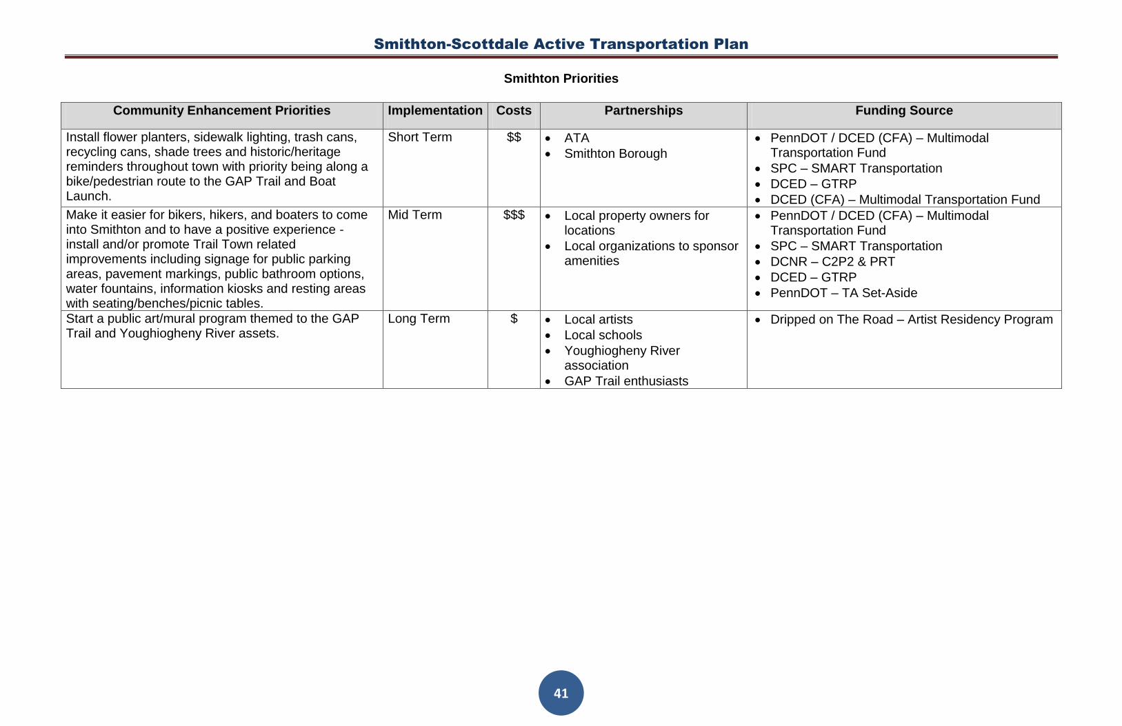
Smithton-Scottdale Active Transportation Plan
41
Smithton Priorities
Community Enhancement Priorities Implementation Costs Partnerships Funding Source
Install flower planters, sidewalk lighting, trash cans, recycling cans, shade trees and historic/heritage reminders throughout town with priority being along a bike/pedestrian route to the GAP Trail and Boat Launch.
Short Term $$ ATA
Smithton Borough
PennDOT / DCED (CFA) – Multimodal Transportation Fund
SPC – SMART Transportation
DCED – GTRP
DCED (CFA) – Multimodal Transportation Fund
Make it easier for bikers, hikers, and boaters to come into Smithton and to have a positive experience - install and/or promote Trail Town related improvements including signage for public parking areas, pavement markings, public bathroom options, water fountains, information kiosks and resting areas with seating/benches/picnic tables.
Mid Term $$$ Local property owners for locations
Local organizations to sponsor amenities
PennDOT / DCED (CFA) – Multimodal Transportation Fund
SPC – SMART Transportation
DCNR – C2P2 & PRT
DCED – GTRP
PennDOT – TA Set-Aside
Start a public art/mural program themed to the GAP Trail and Youghiogheny River assets.
Long Term $ Local artists
Local schools
Youghiogheny River association
GAP Trail enthusiasts
Dripped on The Road – Artist Residency Program

Smithton-Scottdale Active Transportation Plan
42
Scottdale Priorities
Wayfinding Priorities Implementation Costs Partnerships Funding Source
Install signage, create mapping and provide information on Borough website for the inter-community trail route (implement 2015 plan to connect C&C Trail to Garfield Park). Goal is to better connect residents with the route and ultimately to the resources, assets and destinations along the route.
Short Term $ C&C Chapter of RTC
Scottdale Borough
PennDOT / DCED (CFA) – Multimodal Transportation Fund
SPC – SMART Transportation
DCNR – C2P2 & PRT
Install kiosks with information on local history, heritage resources and historical assets along the inter-community bike route and at local C&C.
Short Term $$ Historical Society
Install directional signage (along route), install information kiosk at Stout Trailhead, create mapping and provide information on the Borough website for the on-road portion of the C&C/Jacobs Creek Trail for walkers, bikers and horseback riders.
Mid Term $$ C&C Chapter of RTC
Jacobs Creek Watershed Association
Equestrian organizations
PennDOT / DCED (CFA) – Multimodal Transportation Fund
SPC – SMART Transportation
DCED – GTRP
Install additional directional signage to the Jacobs Creek boat launch area and local parks and amenities (food, bike repair).
Long Term $ Jacobs Creek Watershed Association
Scottdale Borough
PennDOT / DCED (CFA) – Multimodal Transportation Fund
SPC – SMART Transportation
Install signage for parking areas in town. Long Term $ Borough Manager
PennDOT
PennDOT / DCED (CFA) – Multimodal Transportation Fund
SPC – SMART Transportation

Smithton-Scottdale Active Transportation Plan
43
Scottdale Priorities
Bike and Walking Enhancement Priorities Implementation Costs Partnerships Funding Source
Complete sidewalk assessments to inventory sidewalk improvement needs (new sections, repairs, and curb cuts) and install where needed.
Short Term $ Borough Manager SPC – SMART Transportation
DCED (CFA) – Multimodal Transportation Fund
Initiate Borough sidewalk program to fix missing/crooked sidewalks and to install new sections, make repairs and add curb cuts where needed.
Short Term $$ Local property owners
Borough Manger
SPC – SMART Transportation
PennDOT – TA Set-Aside
PennDOT / DCED (CFA) – Multimodal Transportation Fund
Pittsburgh and Broadway St. Improvements – complete sidewalk improvements, install additional ADA curb ramps and crosswalks, pedestrian enhancements at Pittsburgh St. x Broadway St. intersection and install pedestrian crossing actuators at the Pittsburgh St. x Chestnut St. intersection.
Short Term $$$ Borough Manger
Local property owners
SPC – SMART Transportation
PennDOT / DCED (CFA) – Multimodal Transportation Fund
PennDOT – TA Set-Aside
Improve conditions for biking and walking along the inter-community trail route and along Mt. Pleasant road connecting to the C&C trail head (at end of Jacobs Creek Trail).
Mid Term $$ C&C Chapter of RTC SPC – SMART Transportation
PennDOT – TA Set-Aside
PennDOT / DCED (CFA) – Multimodal Transportation Fund
Partner with the C&C Trail Chapter to install comfort stations, lighting and other security improvements at the trailheads.
Long Term $$$ C&C Chapter of RTC
Scottdale Borough
SPC – SMART Transportation
PennDOT – TA Set-Aside
PennDOT / DCED (CFA) – Multimodal Transportation Fund
DCNR – C2P2 & PRT
Install painted and/or separated Bike Lanes in targeted areas.
Long Term $$ PennDOT
Borough Manger
SPC – SMART Transportation
PennDOT – TA Set-Aside
PennDOT / DCED (CFA) – Multimodal Transportation Fund

Smithton-Scottdale Active Transportation Plan
44
Scottdale Priorities
Bike and Walking Enhancement Priorities (cont.) Implementation Costs Partnerships Funding Source
Install sidewalk lighting and focused lighting (within alleyways) along the inter-community trail route and other walking routes.
Short Term $$ Local property owners
Borough Manager
PennDOT / DCED (CFA) – Multimodal Transportation Fund
SPC – SMART Transportation
DCNR – C2P2 & PRT
PennDOT – TA Set-Aside
Install Bike and Pedestrian Friendly amenities including designated resting areas with shade trees, water fountains, bike racks, and tool/equipment/air stations.
Mid Term $$ Local property owners
Borough Manager
SPC – SMART Transportation
PennDOT / DCED (CFA) – Multimodal Transportation Fund
PennDOT – TA Set-Aside
Attract bike shop/rental business to town to promote biking and attract people to use trails.
Long Term $ Local business owners
C&C Chapter of RTC
DCED – Appalachian Regional Commission
Utilize Safe Routes to School and add curb cuts and add connection to west side of town to Grove Street.
Long Term $$ Borough Manger
Local property owners
SPC – SMART Transportation
PennDOT – TA Set-Aside

Smithton-Scottdale Active Transportation Plan
45
Scottdale Priorities
Community Enhancement Priorities Implementation Costs Partnerships Funding Source
Make it easier for bikers, hikers, and boaters to come into Scottdale and to have a positive experience - install and/or promote Trail Town related improvements including signage for public parking areas, pavement markings, public bathroom options, water fountains, information kiosks and resting areas with bike racks/seating/benches/picnic tables.
Short Term $$$ Local volunteers
Social media groups
Local property owners
Borough Manager
SPC – SMART Transportation
DCED – GTRP
PennDOT / DCED (CFA) – Multimodal Transportation Fund
PennDOT – TA Set-Aside
Lead local bike ride from local coffee shop one day per week – possibly Saturday am.
Short Term $ Local volunteers
Social media groups
local coffee shop
C&C Chapter of RTC
Bike shops
Recreation groups
Add a portable restroom at Garfield Park Mid Term $$ Scottdale Borough
Borough Manager
Jacobs Creek Watershed Association
Volunteer grant writers
SPC – SMART Transportation
DCNR – C2P2 & PRT
PennDOT – TA Set-Aside
Organize Lazy River Ride down Jacobs Creek. LongTerm $ Social media groups
Jacobs Creek Watershed Association
DCED – Appalachian Regional Commission
PEC - PA River Sojourn Grant
DCED – GTRP

Smithton-Scottdale Active Transportation Plan
46
Scottdale Priorities
Connectivity Priorities Implementation Costs Partnerships Funding Source
Improve pedestrian and bike access to/from Scottdale and the C&C/Jacobs Creek trail.
Short Term $ Local property owners SPC – SMART Transportation
PennDOT – TA Set-Aside
PennDOT / DCED (CFA) – Multimodal Transportation Fund
Install a trail connection within the existing right-of-way from Garfield Park to 5th Avenue and install a Bike/Pedestrian crossing across 5th Ave. over Jacobs Creek. This section should be consistent with the C&C trail.
Short Term $$$ C&C Chapter of RTC
Westmoreland County Bureau of Parks and Recreation
SPC – SMART Transportation
PennDOT – TA Set-Aside
PennDOT / DCED (CFA) – Multimodal Transportation Fund
Connect Scottdale to the Great Allegheny Passage (GAP) Trail near Connellsville and/or to nearby Game Lands and to Agri-Tourism opportunities.
Mid Term $$$$ GAP trail and adjacent municipalities
Private and public property owners along any potential routes
C&C Chapter of RTC
Local trail enthusiasts
Connellsville trail groups
Local Game Warden
SPC – SMART Transportation
PennDOT – TA Set-Aside
DCED – GTRP
Designate the preferred route to connect the inter-community trail, Loucks Park, Pittsburgh St. Park, Barklay Park, Gazebo Park and Garfield Park.
Mid Term $ Local property owners
Scottdale Borough
PennDOT / DCED (CFA) – Multimodal Transportation Fund
SPC – SMART Transportation
DCNR – C2P2 & PRT
DCED – GTRP
PennDOT – TA Set-Aside

Smithton-Scottdale Active Transportation Plan
47
Scottdale Priorities
Connectivity Enhancement Priorities (cont.) Implementation Costs Partnerships Funding Source
Complete additional regional planning efforts focused on property acquisition, development of connections and outdoor recreation enhancements. These may include a Jacobs Creek Watershed Greenway Plan, a Comprehensive Parks and Recreation Plan, Trail Feasibility Studies, Master Site Development Plans Connectivity Plans and other similar efforts.
Mid Term && Jacobs Creek Watershed Association
PennDOT, DCNR, CFA and DCED
Scottdale Borough
PA Game Commission
Elected State Representatives
Fayette and Westmoreland County Commissioners
Westmoreland Development Council
Regional Foundations
DCNR – C2P2 & PRT
PennDOT / DCED (CFA) – Multimodal Transportation Fund
DCED – GTRP
Foundations
Private Property Donations as match
Municipal and County
Expand appropriate Share the Road markings through town (See MUTCD guidance)
Long Term $ PennDOT
Borough Manager
SPC – SMART Transportation
PennDOT – TA Set-Aside
PennDOT – Multimodal Transportation Fund
DCED – Multimodal Transportation Fund
Designate equestrian trail areas to destinations. Long Term $ Local equestrian groups
Local municipalities
DCED – GTRP
Designate a green belt wrapping around Scottdale following Anderson run from Barclay Park
Long Term $ Scottdale Borough
Borough Manager
Recreation groups
SPC – SMART Transportation
PennDOT – TA Set-Aside
DCED – GTRP


