Smart eDA Ref: 1441590387678 Our Ref: 14272 …€¦ · Town Planning Report Material Change of Use...
79
www.visionsurveysqld.com.au AIRLIE BEACH Unit 4, Gabriel Plaza, 55 Paluma Rd, Cannonvale : PO Box 103, Airlie Beach Qld 4802 : 07 4948 3781 : 07 4948 3233 [email protected] MACKAY Level 1, 36 Wellington St, Mackay : PO Box 1730, Mackay Qld 4740 : 07 4951 0768 : 074953 0340 [email protected] ROCKHAMPTON 1 Denham Street, Rockhampton :PO Box 1337 Rockhampton Qld 4700 : 07 4927 1744 : 07 4922 3164 [email protected] TOWNSVILLE Level 1, 167 Denham St, Townsville : 07 4721 0410 :PO Box 1444 Townsville Qld 4810 [email protected] MORANBAH 3 Griffin St, Moranbah :PO Box 200, Moranbah Qld 4744 : 07 4941 9069 [email protected] DIRECTORS Brian Forrester David Wilson ABN: 84 128 752 947 Surveying | Town Planning | Project Coordination | Mapping | Land Development | Civil & Mining Infrastructure Smart eDA Ref: 1441590387678 Our Ref: 14272 Date: 7 September 2015 Contact: Marcus Fossey 7 September 2015 Mackay Regional Council PO Box 41 MACKAY QLD 4740 Attn: Development Assessment Dear Sir / Madam, RE: LODGEMENT OF DEVELOPMENT APPLICATION FOR MATERIAL CHANGE OF USE FOR A SECOND HOUSE – 244 CLIFTONVILLE ROAD, SARINA – LOT 12 ON SP218373 Vision Surveys (QLD) Pty Ltd acts on behalf of the applicant, Mr. George Meyer, in lodgement of a Development Application pursuant to Section 260 of the Sustainable Planning Act 2009 seeking a Development Permit for Material Change of Use for Second House at 244 Cliftonville Road, Sarina formally described as Lot 12 on SP218373. The following information has been provided to ensure the application is properly made: IDAS Forms 1 & 5; Declaration of Owners’ Consent; Mandatory supporting information as identified under item 4 of IDAS Form 5: Town Planning Report; Proposal Plan Assessment under the applicable codes of the Sarina Shire Planning Scheme 2005; Please note that the client will make payment to Council directly. In accordance Mackay Regional Council’s Fees and Charges Schedule 2015 – 2016, Council’s application fee has been determined as: Material Change of Use (b) Minor Including uses defined in the Sarina Shire Planning Scheme 2005 as Second House Code Assessable $1,670.00 TOTAL $1,670.00 The attached Town Planning Report and its appendices detail the application and assess it under the Sarina Shire Planning Scheme 2005, concluding with a recommendation for approval subject to reasonable and relevant conditions. Should you require any further details or clarification regarding the attached application, please do not hesitate to contact Vision Surveys (QLD) via the attached details. Yours faithfully, Sean Brien Town Planner (BUrbanEnvPlan) Vision Surveys (QLD) – Airlie Beach (07) 4948 3781 Enc Development Application Cc George Meyer
Transcript of Smart eDA Ref: 1441590387678 Our Ref: 14272 …€¦ · Town Planning Report Material Change of Use...

www.visionsurveysqld.com.au
AIRLIE BEACHUnit 4, Gabriel Plaza,
55 Paluma Rd, Cannonvale: PO Box 103,
Airlie Beach Qld 4802: 07 4948 3781: 07 4948 3233
MACKAYLevel 1, 36 Wellington St, Mackay
: PO Box 1730,Mackay Qld 4740: 07 4951 0768: 074953 0340
ROCKHAMPTON1 Denham Street, Rockhampton
:PO Box 1337Rockhampton Qld 4700: 07 4927 1744
: 07 4922 [email protected]
TOWNSVILLELevel 1, 167 Denham St, Townsville
: 07 4721 0410:PO Box 1444
Townsville Qld [email protected]
MORANBAH3 Griffin St, Moranbah
:PO Box 200,Moranbah Qld 4744: 07 4941 9069
DIRECTORSBrian Forrester
David Wilson
ABN: 84 128 752 947
Surveying | Town Planning | Project Coordination | Mapping | Land Development | Civil & Mining Infrastructure
Smart eDA Ref: 1441590387678Our Ref: 14272Date: 7 September 2015Contact: Marcus Fossey
7 September 2015
Mackay Regional CouncilPO Box 41MACKAY QLD 4740
Attn: Development Assessment
Dear Sir / Madam,
RE: LODGEMENT OF DEVELOPMENT APPLICATION FOR MATERIAL CHANGE OF USEFOR A SECOND HOUSE – 244 CLIFTONVILLE ROAD, SARINA – LOT 12 ONSP218373
Vision Surveys (QLD) Pty Ltd acts on behalf of the applicant, Mr. George Meyer, in lodgement of aDevelopment Application pursuant to Section 260 of the Sustainable Planning Act 2009 seeking aDevelopment Permit for Material Change of Use for Second House at 244 Cliftonville Road, Sarinaformally described as Lot 12 on SP218373.
The following information has been provided to ensure the application is properly made: IDAS Forms 1 & 5; Declaration of Owners’ Consent; Mandatory supporting information as identified under item 4 of IDAS Form 5:
Town Planning Report; Proposal Plan Assessment under the applicable codes of the Sarina Shire Planning Scheme 2005;
Please note that the client will make payment to Council directly. In accordance Mackay RegionalCouncil’s Fees and Charges Schedule 2015 – 2016, Council’s application fee has been determined as:
Material Change of Use(b) Minor
Including uses defined in the Sarina Shire Planning Scheme 2005 as Second House
Code Assessable $1,670.00
TOTAL $1,670.00
The attached Town Planning Report and its appendices detail the application and assess it under theSarina Shire Planning Scheme 2005, concluding with a recommendation for approval subject toreasonable and relevant conditions. Should you require any further details or clarification regarding theattached application, please do not hesitate to contact Vision Surveys (QLD) via the attached details.
Yours faithfully,
Sean Brien
Town Planner (BUrbanEnvPlan)
Vision Surveys (QLD) – Airlie Beach
(07) 4948 3781
Enc Development Application
Cc George Meyer
sarahwe
Received (Auto Date)

PREPARED BY:
VISION SURVEYS QLD
PO Box 103
AIRLIE BEACH QLD 4802
VSQ REF: 14272
SMART EDA: 1441590387678
P: (07) 4948 3781 E: [email protected] W: http://www.visionsurveysqld.com.au/
DEVELOPMENT APPLICATION
for a
Development Permit
for
Material Change of Use for a Second House
on land at
244 Cliftonville Road, Sarina
more formally known as
Lot 12 on SP218373
on behalf of
George Meyer
Date: July, 2015
Town Planning ReportMaterial Change of Use for a Second House
244 Cliftonville Road, Sarina Page 2 of 1014272 | July, 2015
TABLE OF CONTENTS
1.0 PRÉCIS................................................................................................................... 42.0 BACKGROUND ........................................................................................................ 5
2.1 Previous Approval(s).......................................................................................... 52.2 Pre-Lodgement Advice ....................................................................................... 5
3.0 SITE ANALYSIS........................................................................................................ 53.1 Configuration.................................................................................................... 53.2 Features........................................................................................................... 63.3 Constraints....................................................................................................... 7
4.0 PROPOSAL ............................................................................................................. 74.1 Details ............................................................................................................. 74.2 Infrastructure .................................................................................................... 8
5.0 ASSESSMENT ......................................................................................................... 85.1 Assessment Manager ......................................................................................... 85.2 Referral Agencies .............................................................................................. 85.3 Public Notification ............................................................................................. 85.4 Sarina Shire Planning Scheme 2005...................................................................... 85.5 State Planning Policy 2014 .................................................................................. 9
6.0 CONCLUSION ........................................................................................................ 10
APPENDICES
Appendix A - Current Title Search, Smart Map, Owners Consent
Appendix B - Proposal Plan(s)
Appendix C - IDAS Forms 1 & 5
Appendix D - Planning Scheme Assessment Tables
Appendix E - SPP Mapping
Appendix F - Correspondence with Mackay Regional Council
Appendix G - Existing Approval (Building Works for ‘first’ Dwelling House)
FIGURES
Figure 1 – Cadastre of Subject Site
Figure 2 – Zoning of Subject Site
Figure 3 – Aerial Image of Subject Site
Figure 4 – Extract of Proposal Plan
Town Planning ReportMaterial Change of Use for a Second House
244 Cliftonville Road, Sarina Page 3 of 1014272 | July, 2015
EXECUTIVE SUMMARY
Vision Surveys (Qld) Pty Ltd has been engaged by Mr. George Meyer (the applicant) to lodge a Development Application for
a Development Permit for Material Change of Use for a Second House (the proposal) on land at 274 Cliftonville Road,
Sarina, more properly described as Lot 12 on SP218373 (the site).
Site Analysis
The site is within the Rural Zone of the Sarina Shire Planning Scheme 2005 (the Planning Scheme) and has an area of
37.59 hectares. It has an irregular shape reminiscent of a battle-axe block with approximate dimensions of 960 metres by
980 metres.
The site has direct access to Council’s road network via an approximately 20 metre street frontage to Cliftonville Road. (refer
to Figure 1: Cadastre of Subject Site). The site is not serviced by Council’s water, sewer and stormwater infrastructure
services. Electricity and telecommunication facilities are available to the site to the requirements of the relevant authorities.
The site contains small sections of an unnamed watercourse that enters the site on the eastern boundary. Vegetation visible
in satellite imagery is mapped locally as an endangered regional ecosystem and by the State Government as MSES –
Regulated Vegetation and (in parts) intersecting a watercourse. The topography is fairly consistently undulating. There is an
existing residence as indicated on the satellite imagery and proposal plan, however it is derelict and Building Approval has
been granted to replace this structure but construction has not yet occurred.
The site has Building approval for a single dwelling house and associated on-site infrastructure that is yet to be constructed.
It is considered to be approved for a low density residential land use consistent with the Rural Zone (refer to Figure 3:
Satellite Image of Subject Site).
The site is identified as being within the following overlays of the Planning Scheme:
• Natural Hazards (Bushfire);
• Conservation Areas (Remnant Vegetation); and
• Economic Resources (GQAL).
The site is identified as being within the following relevant interests within the State Planning Policy 2014 (the SPP):
• Environment and Heritage (Biodiversity & Water Quality); and
• Hazards and Safety (Natural Hazards Risk and Resilience).
Proposal
The proposal is for a Material Change of Use for a Second House. The plan shows an ‘existing dwelling’ which is approved
but yet to be constructed. It is expected that Council will condition requirements for the first house to be constructed prior to
the second. Access will continue to be through the existing street frontage with internal access to be constructed at building /
operational works stage. The site is not serviced by Council’s infrastructure networks and proposes on-site infrastructure in
accordance with Council’s and other relevant authorities’ requirements (refer to Figure 4: Extract of Proposal Plan).
Assessment
The proposal is considered consistent with the Planning Scheme and is Code Assessable. There are no State Referrals
required and it is considered consistent with the State Planning Policy 2014.
The Second House is located an appropriate distance from the existing dwelling (yet to be constructed) and the existing
waterway, riparian vegetation, other areas of significant vegetation and the associated bushfire hazard areas.
Assessment of the environmental factors and hazards on the site has determined that the proposal will not significantly
degrade the environment or enhance the risk of hazards and appropriately avoids and mitigates these issues.
The following Assessment Report provides greater detail on the site, proposal and assessment against the relevant
statutory planning instruments. The report concludes with the recommendation that the proposal should be approved,
subject to reasonable and relevant conditions.
DOCUMENT CONTROL
Version Document Author Reviewer Review DateFinal Draft MCU (Second House) S. Brien L. Glindemann 7 September 2015

Town Planning ReportMaterial Change of Use for a Second House
244 Cliftonville Road, Sarina Page 4 of 1014272 | July, 2015
1.0 PRÉCISBackgroundPrevious Approval N/APre-lodgement Mackay Regional CouncilSubject Site Refer to Appendix A – Current Title and Smart MapAddress 244 Cliftonville Road, SarinaLot on Plan Lot 12 on SP218373Ownership George MeyerLand Use Vacant LandConfiguration Refer to Appendix A – Smart Map
Lot Area (ha) Street Frontage (m) Depth (m)12SP218373 37.59 ~20 (Cliftonville Road) ~960
Secondary Interests Refer to Appendix A – Smart MapName Description Purpose Area
- - - -Surrounding Land Uses Refer to Figures 1, 2 and 3
Features Zone UseNorth Limited vegetation, hilly Rural Low density residential, vacant / agricultureEast Cliftonville Road, riparian
vegetation, flatRural Low density residential, vacant / agriculture
South Rural Residential style Lots,dense vegetation
Rural Low - Medium density residential
West Sparse vegetation, flat Rural Low density residential, vacant / agricultureEnvironment Refer to Figures 1 & 3Vegetation Significant as per Local and State Government mapping. Some riparian.Topography Vastly flat or undulating.Cultural Heritage No areas or features known to occur within the site.ProposalApplication Development PermitProposal Material Change of UseDescription Second HouseAssessmentLocal Authority Mackay Regional CouncilAssessment Level Code AssessablePlanning Scheme Sarina Shire Planning Scheme 2005Zone Code(s) Rural Zone CodeUse Code(s) House CodeOverlay Code(s) Economic Resources Overlay Code
Natural Hazards Management Areas Overlay CodeConservation Areas Overlay Code
Public Notification N/AReferral Agencies (Sustainable Planning Regulation 2009)Schedule Part Table Item State Authority
- - - - NilRelevant State Interests (State Planning Policy 2014)Environment and Heritage Biodiversity (MSES – Wildlife habitat & regulated vegetation (and intersecting a
watercourse); andWater Quality (Climatic regions – stormwater management objectives)
Hazards and Safety Safety and Resilience to Hazards (Flood hazard – Local Government floodmapping area; Bushfire hazard).
AdministrativeLodgement July, 2015Contact Person Sean Brien or Lee Glindemann
(07) 4948 3781 - [email protected]

Town Planning ReportMaterial Change of Use for a Second House
244 Cliftonville Road, Sarina Page 5 of 1014272 | July, 2015
2.0 BACKGROUND
2.1 Previous Approval(s)
There are no previously approved Development Permits relevant to the proposed development.
2.2 Pre-Lodgement Advice
Pre-lodgement advice was sought from the following Local Government Agency:
Mackay Regional Council
Request was made by Vision Surveys QLD regarding the possibility of obtaining approval for a ‘Second
House’, as defined under the Sarina Shire Planning Scheme 2005, prior to the first Dwelling House being
constructed;
Council advised that previous approvals have been granted along these lines where conditions ensure that
the ‘first’ house be constructed before the ‘second’ house;
It was also advised that any proposal for a Second House will require justification that the occupants will
comply with the Planning Scheme’s definition:
“means the use of premises for an additional house to an existing house on the same lot, where the second
house is occupied by a relative or employee of the occupants of the existing house.”
This correspondence has been included in this application, refer to Appendix F – Correspondence with
Mackay Regional Council.
3.0 SITE ANALYSIS
3.1 Configuration
The subject site is located within the Rural Zone of the Sarina Shire Planning Scheme 2005 and has an area of 37.59
hectares. The lot has direct access to Council’s road network via an approximately 20 metre street frontage to Cliftonville
Road. The lot is irregular in shape, reminiscent of a battle-axe block, and has approximate dimensions of 960 metres by 980
metres.
Figure 1: Cadastre of Subject Site (Source: Smart Map)

Town Planning ReportMaterial Change of Use for a Second House
244 Cliftonville Road, Sarina Page 6 of 1014272 | July, 2015
Figure 2: Zoning of Subject Site (Source: Sarina Shire Planning Scheme 2005)
3.2 Features
The site contains small sections of an unnamed watercourse that enters the site on the eastern boundary. Vegetation visible
in satellite imagery is mapped locally as an endangered regional ecosystem and by the State Government as MSES –
Regulated Vegetation and (in parts) intersecting a watercourse. It is therefore expected that this vegetation is significant and
should not be cleared. Remaining areas are mostly cleared of vegetation. The topography is fairly consistently undulating.
There is an existing residence as indicated on the satellite imagery and proposal plan.
Figure 3: Aerial Photograph of Subject Site (Source: QLD Globe)
Town Planning ReportMaterial Change of Use for a Second House
244 Cliftonville Road, Sarina Page 7 of 1014272 | July, 2015
3.3 Constraints
The site is identified as being within the following overlays of the Planning Scheme:
• Natural Hazards (Bushfire);
• Conservation Areas (Remnant Vegetation); and
• Economic Resources (GQAL).
The site is identified as being within the following relevant interests within the State Planning Policy 2014 (the SPP; refer to
Appendix E – SPP Mapping):
• Environment and Heritage:
o Biodiversity:
MSES – Wildlife habitat;
MSES – Regulated vegetation; and
MSES – Regulated vegetation (intersecting a watercourse).
o Water Quality:
Climatic regions – stormwater management design objectives.
• Hazards and Safety:
o Natural Hazards Risk and Resilience:
Flood hazard area – Local Government flood mapping area;
Flood hazard area – Level 1 – Queensland floodplain assessment overlay; and
Bushfire hazard area (bushfire prone area) and Potential bushfire impact buffer.
4.0 PROPOSAL
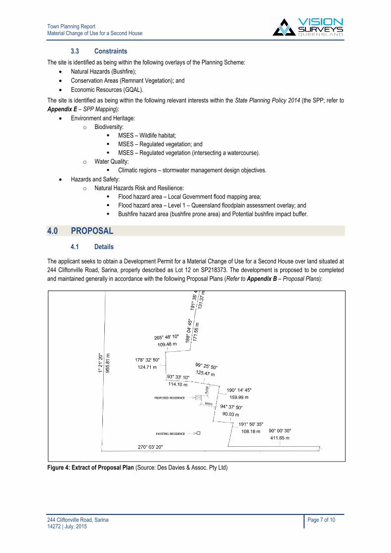
4.1 Details
The applicant seeks to obtain a Development Permit for a Material Change of Use for a Second House over land situated at
244 Cliftonville Road, Sarina, properly described as Lot 12 on SP218373. The development is proposed to be completed
and maintained generally in accordance with the following Proposal Plans (Refer to Appendix B – Proposal Plans):
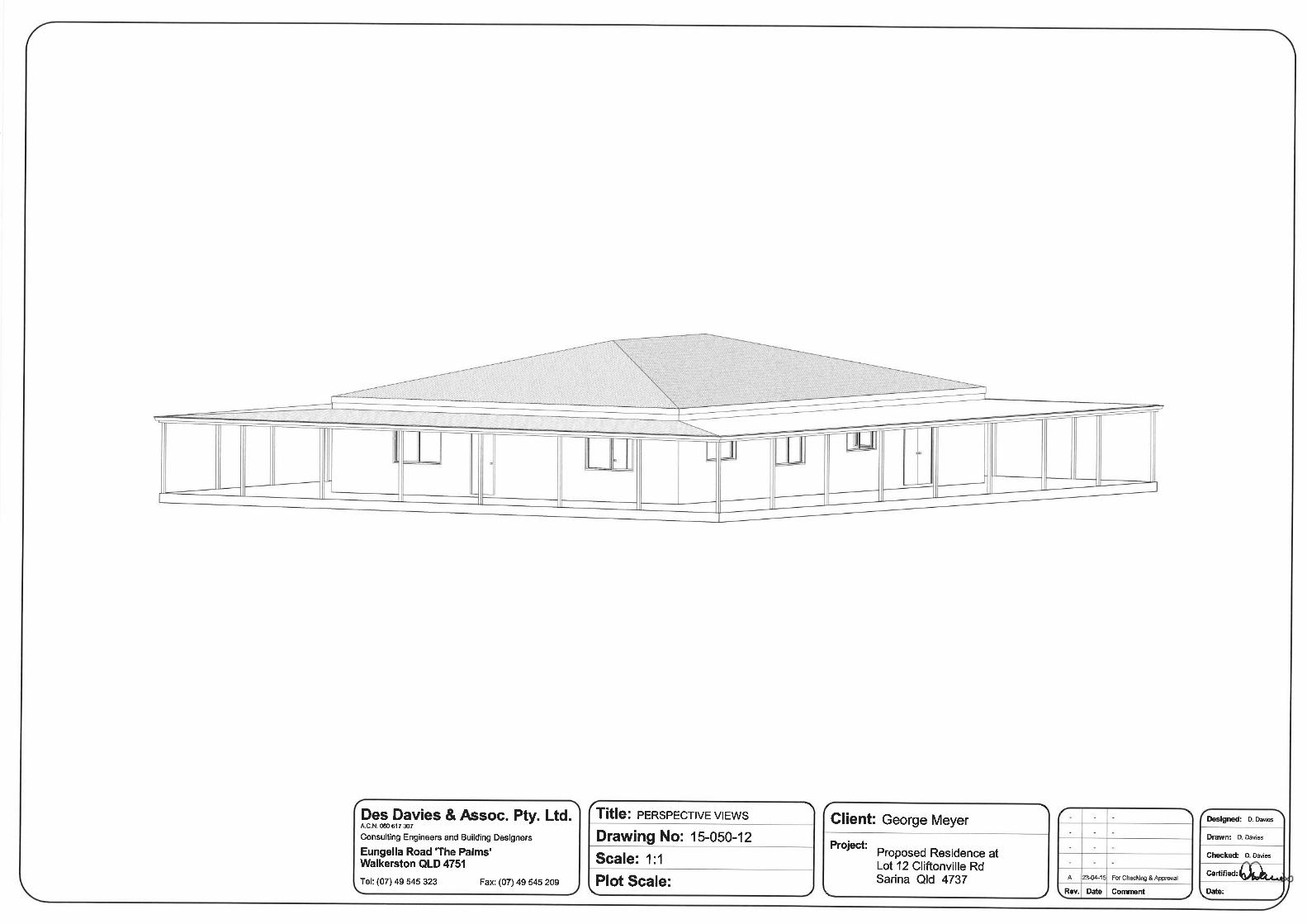
Figure 4: Extract of Proposal Plan (Source: Des Davies & Assoc. Pty Ltd)

Town Planning ReportMaterial Change of Use for a Second House
244 Cliftonville Road, Sarina Page 8 of 1014272 | July, 2015
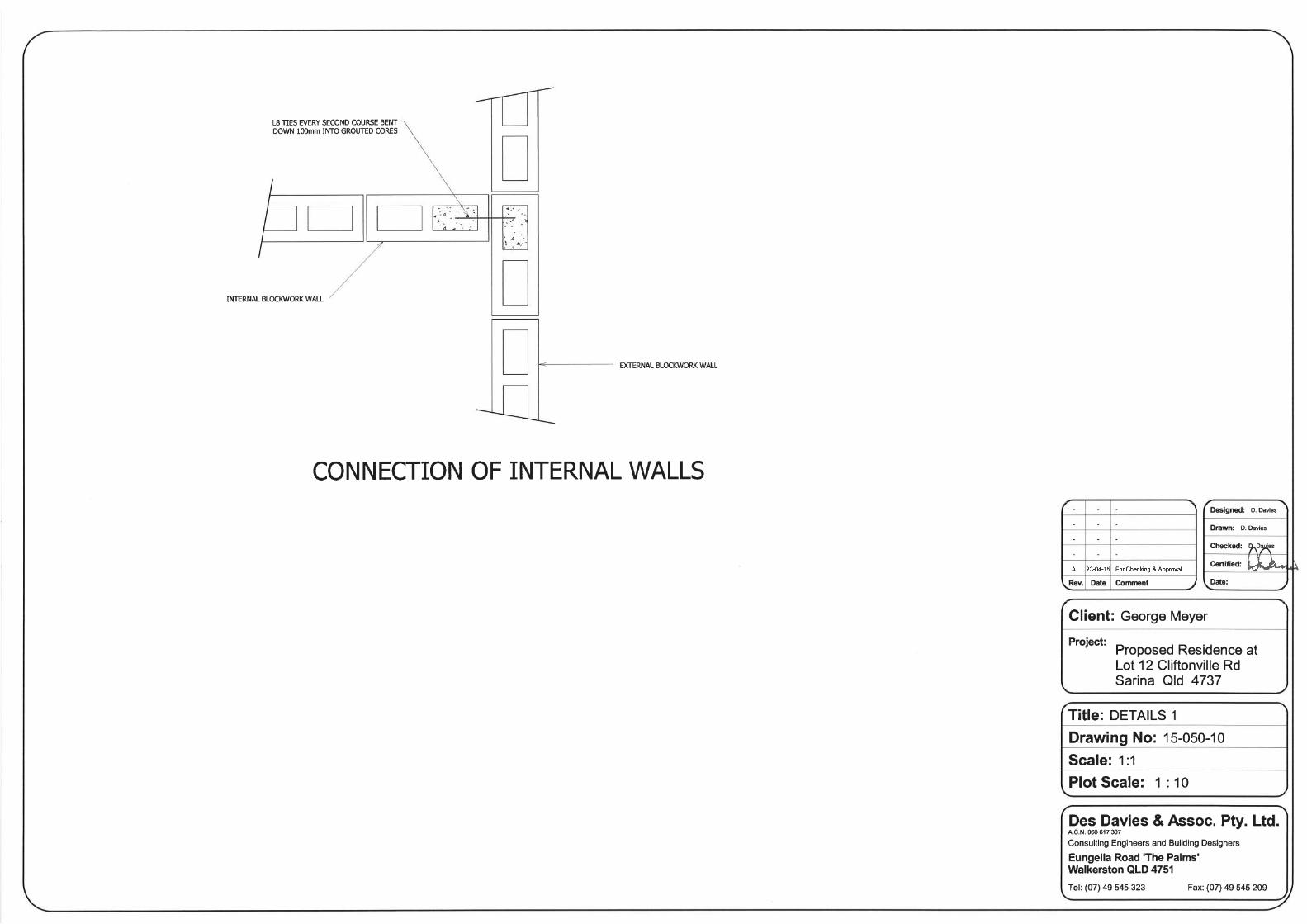
Plan/Document Name Prepared By Plan Number Dated
Site Plan Des Davies & Assoc. Pty Ltd 15-050-01 23-04-2015
Floor Plan Des Davies & Assoc. Pty Ltd 15-050-02 23-04-2015
Elevations A & B Des Davies & Assoc. Pty Ltd 15-050-03 23-04-2015
Elevations C & D Des Davies & Assoc. Pty Ltd 15-050-04 23-04-2015
Perspective Views Des Davies & Assoc. Pty Ltd 15-050-12 23-04-2015
The site has Building Approval for an existing dwelling that is yet to be constructed (indicated on the proposal plan as
‘existing dwelling’. It is proposed that the Second House be conditioned to require that the ‘first’ house be constructed prior
to the Second House.
The proposed Second House is located appropriately far from the existing house (yet to be constructed), property
boundaries and mapped hazard overlays within the site.
4.2 Infrastructure
The below table provides more scope pertaining to the servicing of the proposed Second House:
Service Comments
Sewerage On site effluent disposal
Access Via existing street frontage to Cliftonville Road of approximately 20 metres, and internaldriveway to be constructed at building / operational works stage
Water Supply On site water tanks or bore if a viable alternative
Electricity To the requirements of the relevant authority (Ergon)
Telecommunications To the requirements of the relevant authority (Telstra)
Stormwater Via overland flow, no change to existing contours and no significant increase in impermeablesurfaces
5.0 ASSESSMENT
5.1 Assessment Manager
In accordance with the Sustainable Planning Regulation 2009 the assessment manager is determined to be the Local
Government:
Schedule 6, Table 1, Item 1(a)(i) If the application is for– development completely in a single local government
area and– any aspect of the development is assessable against the planning scheme, a temporary local planning
instrument, master plan or preliminary approval to which section 242 of the Act applies.
Therefore, the Assessment Manager is Mackay Regional Council.
5.2 Referral Agencies
A review of the Sustainable Planning Regulation 2009 has determined the proposed development will not trigger referral to
any State Government agency.
5.3 Public Notification
The application is Code Assessable under the Sarina Shire Planning Scheme 2005 and does not require any period of
public notification in accordance with section 295 of the Sustainable Planning Act 2009.
5.4 Sarina Shire Planning Scheme 2005
The proposed development is Code Assessable, requiring assessment against the following Codes of the Sarina Shire
Planning Scheme 2005 (refer to Appendix D – Planning Scheme Assessment Tables):
Rural Zone Code;
House Code;
Economic Resources Overlay Code;
Natural Hazards Management Code; and
Conservation Areas Overlay Code.

Town Planning ReportMaterial Change of Use for a Second House
244 Cliftonville Road, Sarina Page 9 of 1014272 | July, 2015
5.5 State Planning Policy 2014
An assessment has been undertaken against the State Planning Policy 2014. State Interests identified through the State
Planning Policy 2014 and Interactive Mapping System (Development Assessment) and considered relevant to the proposed
development have been addressed in the table below:
Relevant State Interest Comments
Environmentand Heritage
BiodiversityRequiring an environmental offset under a local planninginstrument (including a local government condition to provide anenvironmental offset) must be consistent with the EnvironmentalOffsets Act 2014.
Where the land relates to a matter of state environmentalsignificance, if the application is for:
(a) OPW, or
(b) MCU (other than for a dwelling house), or
(c) RoL that results in more than six lots or lots less than fivehectares.
MSES – Regulated vegetation: Not Applicable
The proposed Second House is essentially a DwellingHouse, however for the sake of ensuring thoroughassessment, the proposed Second House, if it were to bean assessable MCU; it is not located within the part of thesite that contains Regulated Vegetation.
MSES – Regulated vegetation (intersecting awatercourse): Not Applicable
The proposed Second House is essentially a DwellingHouse, however for the sake of ensuring thoroughassessment, the proposed Second House, if it were to bean assessable MCU; it is not located within the part of thesite that contains Regulated Vegetation (intersecting awatercourse).
Water QualityReceiving waters—a development application for any of thefollowing:
(1) a material change of use for urban purposes that involves aland area greater than 2500m² that:
(a) will result in an impervious area greater than 25% of the netdevelopable area, or
(b) will result in six or more dwellings, or
(2) reconfiguring a lot for urban purposes that involves a land areagreater than 2500m² and will result in six or more lots, or
(3) operational works for urban purposes that involve disturbingmore than 2500m² of land.
Acid sulfate soils—a development application that relates to:
(1) an acid sulfate soils affected area, and
(2) land at or below five metres AHD where the natural groundlevel is below 20m AHD, if the application is for a material changeof use, or operational works, involving:
(a) excavating or otherwise removing 100m³ or more of soil orsediment, or
(b) filling of land with 500m³ or more of material with an averagedepth of 0.5m or more.
Climatic regions – stormwater management objectives:Not Applicable
The MCU is on land greater than 2,500m²; however it willnot result in an impervious area greater than 25% of the netdevelopable area and will not result in six (6) or moredwellings.
Safety andResilience to
Hazards
Natural Hazards, Risk and ResilienceA development application for a material change of use,reconfiguring a lot or operational works on land within:
(1) a flood hazard area, or
(2) a bushfire hazard area, or
(3) a landslide hazard area, or
(4) a coastal hazard area
Flood hazard area – Local Government flood mappingarea: Not Applicable
This layer is all-encompassing and reflects back to LocalGovernment flood mapping, neither of which identify anyareas as requiring assessment.
Flood hazard area – Level 1 – Queensland floodplainassessment area: Not Applicable
The area of the site affected by this overlay is on the‘handle’ of the battle-axe, therefore would only ever be usedfor access. It would be up to the design of the internalaccess driveway at the time of Building / Operational worksto demonstrate flood-free access. The proposed SecondHouse is not located in or near this hazard.
Medium, High and Very High Bushfire hazard area(Bushfire prone area) and Potential bushfire impactbuffer: Complies
The proposed Second Dwelling is within the Potentialbushfire impact buffer area, but impacts will be mitigated asoutlined in assessment of this hazard through the PlanningScheme (which accurately reflects the requirements of theSPP).

Town Planning ReportMaterial Change of Use for a Second House
244 Cliftonville Road, Sarina Page 10 of 1014272 | July, 2015
6.0 CONCLUSION
This report forms part of a Development Application seeking approval for a Development Permit for a Material Change of
Use for a Second House.
The required level of Code Assessment has been undertaken and has demonstrated that the proposal is consistent with the
Sarina Shire Planning Scheme 2005.
The subject site is greater than the minimum requirement of 30 hectares for a Second House;
The proposal generally complies with the relevant provisions of the Sarina Shire Planning Scheme 2005;
The proposal does not compromise Good Quality Agricultural Land or increase the risk of bushfire hazard to
people of property and will not require any clearing of remnant (or riparian) vegetation;
The Second House has ample room to supply all necessary on-site infrastructure to the requirements of Council
and any other relevant authorities; and
Despite the fact that the ‘existing house’ has not yet been constructed, correspondence with Council indicates that
conditions can be included that require the ‘first’ house to be constructed before the Second House; and
Refer to Appendix G to see copies of the existing building approvals for the ‘first’ Dwelling House that
demonstrates the developer’s intent to construct this structure prior to the ‘Second House’.
It is considered that the proposal is a positive outcome for Mackay Regional Council and is recommended for approval
subject to reasonable and relevant conditions.

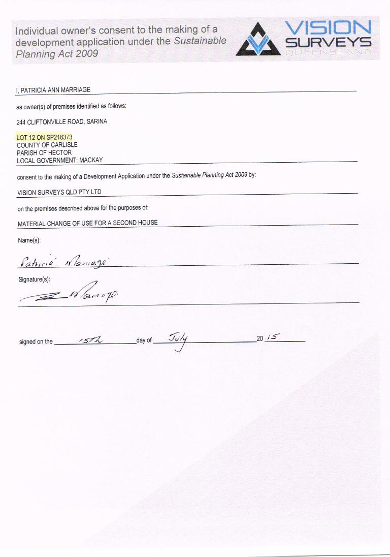
Appendix A
Current Title SearchSmart Map
Owners Consent

CURRENT TITLE SEARCH DEPT OF NATURAL RESOURCES AND MINES, QUEENSLAND Request No: 21294664Search Date: 30/06/2015 15:48 Title Reference: 50907978 Date Created: 11/03/2013 Previous Title: 21251161 50796633 REGISTERED OWNER Dealing No: 714928492 08/02/2013
PATRICIA ANN MARRIAGE ESTATE AND LAND Estate in Fee Simple LOT 12 SURVEY PLAN 218373 County of CARLISLE Parish of HECTOR Local Government: MACKAY EASEMENTS, ENCUMBRANCES AND INTERESTS 1. Rights and interests reserved to the Crown by Deed of Grant No. 10508055 (POR 655) 2. LEASE No 601446533 (N91242) 22/04/1921 OF PART OF THE LAND TO PLANE CREEK CENTRAL MILL COMPANY LIMITED FOR 99 YEARS COMMENCING 01 JAN 1920 3. WRIT No 715634629 05/03/2014 at 10:53 BATH PROPERTIES PTY LTD A.C.N. 127 149 473 ADMINISTRATIVE ADVICESDealing Type Lodgement Date Status709497640 ACCESS RIGHT 06/04/2006 08:19 CURRENT SUGAR INDUSTRY ACT 1999709680892 ACCESS RIGHT 15/06/2006 10:17 CURRENT SUGAR INDUSTRY ACT 1999709680898 ACCESS RIGHT 15/06/2006 10:18 CURRENT SUGAR INDUSTRY ACT 1999711626602 ACCESS RIGHT 07/05/2008 10:34 CURRENT SUGAR INDUSTRY ACT 1999711626610 ACCESS RIGHT 07/05/2008 10:35 CURRENT SUGAR INDUSTRY ACT 1999711626617 ACCESS RIGHT 07/05/2008 10:36 CURRENT SUGAR INDUSTRY ACT 1999711626646 ACCESS RIGHT 07/05/2008 10:37 CURRENT SUGAR INDUSTRY ACT 1999711626684 ACCESS RIGHT 07/05/2008 10:40 CURRENT SUGAR INDUSTRY ACT 1999713280588 VEG NOTICE 08/06/2010 14:59 CURRENT VEGETATION MANAGEMENT ACT 1999 Page 1/2

CURRENT TITLE SEARCH DEPT OF NATURAL RESOURCES AND MINES, QUEENSLAND Request No: 21294664Search Date: 30/06/2015 15:48 Title Reference: 50907978 Date Created: 11/03/2013 ADMINISTRATIVE ADVICES (Continued)Dealing Type Lodgement Date Status713325575 VEG NOTICE 01/07/2010 11:43 CURRENT VEGETATION MANAGEMENT ACT 1999UNREGISTERED DEALINGS - NIL CERTIFICATE OF TITLE ISSUED - No
Caution - Charges do not necessarily appear in order of priority
** End of Current Title Search **
COPYRIGHT THE STATE OF QUEENSLAND (DEPT OF NATURAL RESOURCES AND MINES) [2015]Requested By: D APPLICATIONS GLOBAL X Page 2/2

3RP736122
FH
43.96ha
5RP742162
FH
21.14ha
1
RP
722897
8RP749073
FH
19.55ha9
RP749073
FH
12.23ha
1SP157579
FH
95.09ha
3
RP906166
2.165ha
86
CI462
2
RP738330
FH
10.255ha
1RP742192
FH
38.25ha
869C1245
FH
41.683ha
2RP704488
FH
14.89ha
1
RP730484
FH
11.83ha
7
RP738330
10
RP8455319
RP845531
5
RP
739428
2
RP
817077
FH
5.743ha
5
RP732419
3
RP732415
6
RP
739428
1
RP
724627
1
RP
809681
3
RP845512
FH
13.711ha 4
RP748954
2
RP845512
4
RP748977
5RP748977
FH
131.928ha
3
RP
817077
FH
5.334ha
1
RP
837280
FH
5.272ha
8
RP845531
7
RP845531
5
RP890086
FH
8.259ha15SP110543
FH
59.97ha
14SP110543
FH
148.4ha
10
SP
110543
11
SP
110543
12
SP
110543
A
RP
732671
3SP132657
FH
40.963ha
3
SP136307
FH
11.62ha4SP136307
FH15.24ha
10
SP225750
FH
4.752ha11
SP225750
FH
3.927ha
2SP218361
FH
56.87ha
1
SP
235053
2
SP
235053
12SP218373
FH
37.59ha
9
SP
218373 10
SP
218373
2.46ha
11
SP
218373
2.121ha
2RP704491
FH
55.963ha
1RP704491
FH
30.685ha
2RP722214
FH
83.608ha
4
RP730623
FH
6.067ha 5
RP730623
4
RP8491213
RP
8491215
RP849121
A
RP
722214
1
SP206923
FH
7.074ha
2SP206923
FH
100.5ha 5
SP213264
FH
8.86ha
1RP704495
FH
70.618ha
29
RP704490
FH
9.88ha
28
RP704490
FH
8.621ha
2RP704492
FH
42.166ha
6C1248
FH
116.904ha
ROAD
GARRETT
ROAD
LEL
CLIFTONVI
ST
AR
RR
D
RO
AD
ROAD
GRASSTREEROAD
GRASSTREEROAD
DCDB
Lot/Plan 12/SP218373
Area/Volume 37.59ha
Tenure FREEHOLD
Local Government MACKAY REGIONAL
Locality SARINA
Parish HECTOR
County CARLISLE
Segment/Parcel 61935/105
SUBJECT PARCEL DESCRIPTION
SCALE 1 : 20000HORIZONTAL DATUM:GDA94 ZONE:55
m
400 800 1200 1600 20000
8755-31221
STANDARD MAP NUMBER
149°14'37".962
21°21'26".103
GRASSTREE BEACH
2.99 KM
MAP WINDOW POSITION &NEAREST LOCATION
PRINTED (dd/mm/yyyy) 30/06/2015
DCDB 29/06/2015 (Lots with an area less than 3000m² are not shown)
Users of the information recorded in this document (the Information) accept all responsibility andrisk associated with the use of the Information and should seek independent professional advice inrelation to dealings with property.
Despite Department of Natural Resources and Mines(DNRM)'s best efforts, DNRM makesno representations or warranties in relation to the Information, and, to the extent permitted by law,exclude or limit all warranties relating to correctness, accuracy, reliability, completeness orcurrency and all liability for any direct, indirect and consequential costs, losses, damages andexpenses incurred in any way (including but not limited to that arising from negligence) inconnection with any use of or reliance on the Information
For further information on SmartMap products visit http://nrw.qld.gov.au/property/mapping/blinmap
CLIENT SERVICE STANDARDS
SmartMapAn External Product of
SmartMap Information Services
Based upon an extraction from the
Digital Cadastral Data Base
(c) The State of Queensland,(Department of NaturalResources and Mines) 2015.
7 32 000m E
32
33
33
34
34
1
76 36 000 m N36
2
3737
3
3838
GDA
21°22'19".461
149°13'49".697 149°15'00" 149°15'26".227
21°22'19".461
21°20'32".744
149°15'26".227149°15'00"
21°20'32".744
149°13'49".697

Appendix B
Proposal Plans


Appendix C
IDAS Form 1 – Application DetailsIDAS Form 5 – Material Change of Use

IDAS form 1—Application detailsVersion 4.1—4 July 2014
IDAS form 1—Application details(Sustainable Planning Act 2009 version 4.1 effective 4 July 2014)
This form must be used for ALL development applications.
You MUST complete ALL questions that are stated to be a mandatory requirement unless otherwise identified on thisform.
For all development applications, you must:
• complete this form (IDAS form 1—Application details)
• complete any other forms relevant to your application
• provide any mandatory supporting information identified on the forms as being required to accompany yourapplication.
Attach extra pages if there is insufficient space on this form.
All terms used on this form have the meaning given in the Sustainable Planning Act 2009 (SPA) or the SustainablePlanning Regulation 2009.
This form and any other IDAS form relevant to your application must be used for development applications relating tostrategic port land and Brisbane core port land under the Transport Infrastructure Act 1994 and airport land under theAirport Assets (Restructuring and Disposal) Act 2008. Whenever a planning scheme is mentioned, take it to mean landuse plan for the strategic port land, Brisbane core port land or airport land.
PLEASE NOTE: This form is not required to accompany requests for compliance assessment.
This form can also be completed online using MyDAS at www.dsdip.qld.gov.au/MyDAS
Mandatory requirements
Applicant details (Note: the applicant is the person responsible for making the application and need not be the ownerof the land. The applicant is responsible for ensuring the information provided on all IDAS application forms is correct.Any development permit or preliminary approval that may be issued as a consequence of this application will be issuedto the applicant.)
Name/s (individual or company name in full) George Meyer
C/- Vision Surveys (QLD) Pty Ltd
For companies, contact name Marcus Fossey
Postal address PO Box 1730
Suburb Mackay
State Queensland Postcode 4740
Country Australia
Contact phone number (07) 4951 0768
Mobile number (non-mandatory requirement)

IDAS form 1—Application detailsVersion 4.1—4 July 2014
Fax number (non-mandatory requirement)
Email address (non-mandatory requirement) mfossey
@visionsurveysqld.com.au
Applicant’s reference number (non-mandatoryrequirement)
14272
1. What is the nature of the development proposed and what type of approval is being sought?
Table A—Aspect 1 of the application (If there are additional aspects to the application please list in Table B—Aspect 2.)
a) What is the nature of the development? (Please only tick one box.)
Material change of use Reconfiguring a lot Building work Operational work
b) What is the approval type? (Please only tick one box.)
Preliminary approvalunder s241 of SPA
Preliminary approvalunder s241 and s242of SPA
Development permit
c) Provide a brief description of the proposal, including use definition and number of buildings or structures whereapplicable (e.g. six unit apartment building defined as a multi-unit dwelling, 30 lot residential subdivision etc.)
Second House / ancillary to dwelling
d) What is the level of assessment? (Please only tick one box.)
Impact assessment Code assessment
Table B—Aspect 2 of the application (If there are additional aspects to the application please list in Table C—Additional aspects of the application.)
a) What is the nature of development? (Please only tick one box.)
Material change of use Reconfiguring a lot Building work Operational work
b) What is the approval type? (Please only tick one box.)
Preliminary approvalunder s241 of SPA
Preliminary approvalunder s241 and s242of SPA
Developmentpermit
c) Provide a brief description of the proposal, including use definition and number of buildings or structures whereapplicable (e.g. six unit apartment building defined as a multi-unit dwelling, 30 lot residential subdivision etc.)
d) What is the level of assessment?
Impact assessment Code assessment
Table C—Additional aspects of the application (If there are additional aspects to the application please list in aseparate table on an extra page and attach to this form.)
Refer attached schedule Not required

IDAS form 1—Application detailsVersion 4.1—4 July 2014
2. Location of the premises (Complete Table D and/or Table E as applicable. Identify each lot in a separate row.)
Table D—Street address and lot on plan for the premises or street address and lot on plan for the land adjoining oradjacent to the premises (Note: this table is to be used for applications involving taking or interfering with water).(Attach a separate schedule if there is insufficient space in this table.)
Street address and lot on plan (All lots must be listed.)
Street address and lot on plan for the land adjoining or adjacent to the premises (Appropriate fordevelopment in water but adjoining or adjacent to land, e.g. jetty, pontoon. All lots must be listed.)
Street address Lot on plandescription
Local government area(e.g. Logan, Cairns)
Lot Unitno.
Streetno.
Street name and officialsuburb/ locality name
Post-code
Lot no. Plan typeand plan no.
i) 244 Cliftonville Road, Sarina 12 SP218373 Mackay
ii)
iii)
Planning scheme details (If the premises involves multiple zones, clearly identify the relevant zone/s for each lot in aseparate row in the below table. Non-mandatory)
Lot Applicable zone / precinct Applicable local plan / precinct Applicable overlay/s
i)
ii)
iii)
Table E—Premises coordinates (Appropriate for development in remote areas, over part of a lot or in water notadjoining or adjacent to land e.g. channel dredging in Moreton Bay.) (Attach a separate schedule if there is insufficientspace in this table.)
Coordinates(Note: place each set of coordinates in a separate row)
Zonereference
Datum Local governmentarea (if applicable)
Easting Northing Latitude Longitude
GDA94
WGS84
other
3. Total area of the premises on which the development is proposed (indicate square metres)
37.59 hectares
4. Current use/s of the premises (e.g. vacant land, house, apartment building, cane farm etc.)
Vacant land

IDAS form 1—Application detailsVersion 4.1—4 July 2014
5. Are there any current approvals (e.g. a preliminary approval) associated with this application? (Non-mandatory requirement)
No Yes—provide details below
List of approval reference/s Date approved (dd/mm/yy) Date approval lapses (dd/mm/yy)
6. Is owner’s consent required for this application? (Refer to notes at the end of this form for more information.)
No
Yes—complete either Table F, Table G or Table H as applicable
Table F
Name of owner/s of the land
I/We, the above-mentioned owner/s of the land, consent to the making of this application.
Signature of owner/s of the land
Date
Table G
Name of owner/s of the land
The owner’s written consent is attached or will be provided separately to the assessment manager.
Table H
Name of owner/s of the land
By making this application, I, the applicant, declare that the owner has given written consent to the making of the application.
7. Identify if any of the following apply to the premises (Tick applicable box/es.)
Adjacent to a water body, watercourse or aquifer (e.g. creek, river, lake, canal)—complete Table I
On strategic port land under the Transport Infrastructure Act 1994—complete Table J
In a tidal water area—complete Table K
On Brisbane core port land under the Transport Infrastructure Act 1994 (No table requires completion.)
On airport land under the Airport Assets (Restructuring and Disposal) Act 2008 (no table requires completion)
Listed on either the Contaminated Land Register (CLR) or the Environmental Management Register (EMR) underthe Environmental Protection Act 1994 (no table requires completion)
Table I
Name of water body, watercourse or aquifer

IDAS form 1—Application detailsVersion 4.1—4 July 2014
Table J
Lot on plan description for strategic port land Port authority for the lot
Table K
Name of local government for the tidal area (if applicable) Port authority for the tidal area (if applicable)
8. Are there any existing easements on the premises? (e.g. for vehicular access, electricity, overland flow,water etc)
No Yes—ensure the type, location and dimension of each easement is included in the plans submitted
9. Does the proposal include new building work or operational work on the premises? (Including anyservices)
No Yes—ensure the nature, location and dimension of proposed works are included in plans submitted
10. Is the payment of a portable long service leave levy applicable to this application? (Refer to notes at theend of this form for more information.)
No—go to question 12 Yes
11. Has the portable long service leave levy been paid? (Refer to notes at the end of this form for moreinformation.)
No
Yes—complete Table L and submit with this application the yellow local government/private certifier’s copy of thereceipted QLeave form
Table L
Amount paid Date paid
(dd/mm/yy)
QLeave project number (6 digit numberstarting with A, B, E, L or P)
12. Has the local government agreed to apply a superseded planning scheme to this application undersection 96 of the Sustainable Planning Act 2009?
No
Yes—please provide details below
Name of local government Date of written notice givenby local government(dd/mm/yy)
Reference number of written notice givenby local government (if applicable)

IDAS form 1—Application detailsVersion 4.1—4 July 2014
13. List below all of the forms and supporting information that accompany this application (Include all IDASforms, checklists, mandatory supporting information etc. that will be submitted as part of this application. Note:this question does not apply for applications made online using MyDAS)
Description of attachment or title of attachment Method of lodgement toassessment manager
IDAS Form 5 (MCU) Electronic
Planning Report and Assessment Tables Electronic
Owner’s Consent Electronic
Proposal Plans Electronic
14. Applicant’s declaration
By making this application, I declare that all information in this application is true and correct (Note: it is unlawful toprovide false or misleading information)
Notes for completing this form
• Section 261 of the Sustainable Planning Act 2009 prescribes when an application is a properly-made application.Note, the assessment manager has discretion to accept an application as properly made despite any non-compliance with the requirement to provide mandatory supporting information under section 260(1)(c) of theSustainable Planning Act 2009
Applicant details• Where the applicant is not a natural person, ensure the applicant entity is a real legal entity.
Question 1• Schedule 3 of the Sustainable Planning Regulation 2009 identifies assessable development and the type of
assessment. Where schedule 3 identifies assessable development as “various aspects of development” theapplicant must identify each aspect of the development on Tables A, B and C respectively and as required.
Question 6• Section 263 of the Sustainable Planning Act 2009 sets out when the consent of the owner of the land is required for
an application. Section 260(1)(e) of the Sustainable Planning Act 2009 provides that if the owner’s consent isrequired under section 263, then an application must contain, or be accompanied by, the written consent of theowner, or include a declaration by the applicant that the owner has given written consent to the making of theapplication. If a development application relates to a state resource, the application is not required to be supportedby evidence of an allocation or entitlement to a state resource. However, where the state is the owner of thesubject land, the written consent of the state, as landowner, may be required. Allocation or entitlement to the stateresource is a separate process and will need to be obtained before development commences.
Question 7• If the premises is listed on either the Contaminated Land Register (CLR) or the Environmental
Management Register (EMR) under the Environmental Protection Act 1994 it may be necessary toseek compliance assessment. Schedule 18 of the Sustainable Planning Regulation 2009 identifieswhere compliance assessment is required.
Question 11• The Building and Construction Industry (Portable Long Service Leave) Act 1991 prescribes when the portable long
service leave levy is payable.• The portable long service leave levy amount and other prescribed percentages and rates for calculating the levy
are prescribed in the Building and Construction Industry (Portable Long Service Leave) Regulation 2002.
IDAS form 1—Application detailsVersion 4.1—4 July 2014
Department of State Development, Infrastructure and PlanningPO Box 15009 City East Qld 4002tel 13 QGOV (13 74 68)[email protected]
www.dsdip.qld.gov.au
Question 12• The portable long service leave levy need not be paid when the application is made, but the Building and
Construction Industry (Portable Long Service Leave) Act 1991 requires the levy to be paid before a developmentpermit is issued.
• Building and construction industry notification and payment forms are available from any Queensland post office oragency, on request from QLeave, or can be completed on the QLeave website at www.qleave.qld.gov.au. Forfurther information contact QLeave on 1800 803 481 or visit www.qleave.qld.gov.au.
Privacy—The information collected in this form will be used by the Department of State Development, Infrastructureand Planning (DSDIP), assessment manager, referral agency and/or building certifier in accordance with theprocessing and assessment of your application. Your personal details should not be disclosed for a purpose outside ofthe IDAS process or the provisions about public access to planning and development information in the SustainablePlanning Act 2009, except where required by legislation (including the Right to Information Act 2009) or as required byParliament. This information may be stored in relevant databases. The information collected will be retained asrequired by the Public Records Act 2002.
OFFICE USE ONLY
Date received Reference numbers
NOTIFICATION OF ENGAGEMENT OF A PRIVATE CERTIFIER
To Council. I have been engaged as the private certifier for thebuilding work referred to in this application
Date of engagement NameBSA Certification licensenumber
Buildingclassification/s
QLEAVE NOTIFICATION AND PAYMENT (For completion by assessment manager or private certifier ifapplicable.)
Description of the workQLeave projectnumber
Amount paid($)
Date paid
Date receiptedform sighted byassessmentmanager
Name of officerwho sighted theform
The Sustainable Planning Act 2009 is administered by the Department of State Development, Infrastructure andPlanning. This form and all other required application materials should be sent to your assessment manager and anyreferral agency.

IDAS form 5—Material change of use assessableagainst a planning scheme(Sustainable Planning Act 2009 version 3.0 effective 1 July 2013)
This form must be used for development applications for a material change of use assessable against a planningscheme.
You MUST complete ALL questions that are stated to be a mandatory requirement unless otherwise identified on thisform.
For all development applications, you must:
• complete IDAS form 1—Application details
• complete any other forms relevant to your application
• provide any mandatory supporting information identified on the forms as being required to accompany yourapplication.
Attach extra pages if there is insufficient space on this form.
All terms used on this form have the meaning given in the Sustainable Planning Act 2009 (SPA) or the SustainablePlanning Regulation 2009.
This form must also be used for material change of use on strategic port land and Brisbane core port land under theTransport Infrastructure Act 1994 and airport land under the Airport Assets (Restructuring and Disposal) Act 2008 thatrequires assessment against the land use plan for that land. Whenever a planning scheme is mentioned, take it tomean land use plan for the strategic port land, Brisbane core port land or airport land.
This form can also be completed online using MyDAS at www.dsdip.qld.gov.au/MyDAS
Mandatory requirements
1. Describe the proposed use. (Note: this is to provide additional detail to the information provided in question 1of IDAS form 1—Application details. Attach a separate schedule if there is insufficient space in this table.)
General explanation of theproposed use
Planning schemedefinition (include eachdefinition in a new row)(non-mandatory)
No. of dwelling units(if applicable) orgross floor area (ifapplicable)
Days andhours ofoperation(if applicable)
No. ofemployees(if applicable)
Ancillary dwelling Second House 1 x 396m² N/A N/A
2. Are there any current approvals associated with the proposed material change of use?(e.g. a preliminary approval.)
No Yes—provide details below
List of approval reference/s Date approved (dd/mm/yy) Date approval lapses (dd/mm/yy)
IDAS form 5—Material change of use assessableagainst a planning scheme
Version 3.0—1July 2013
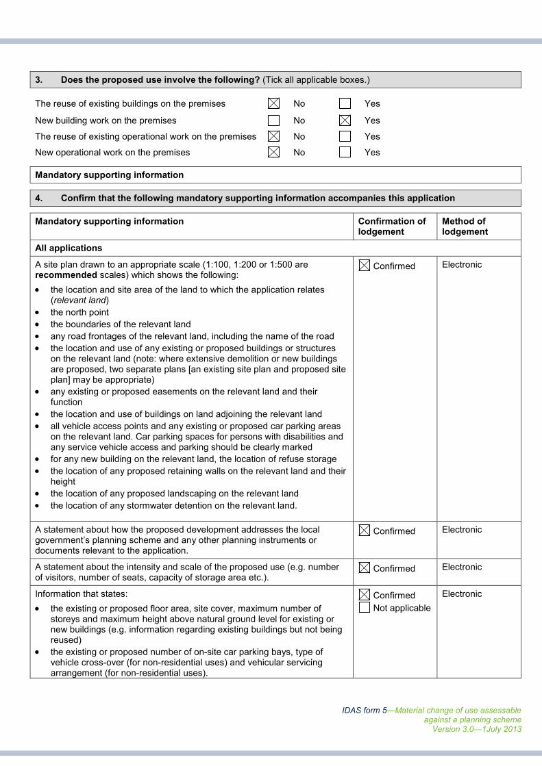
3. Does the proposed use involve the following? (Tick all applicable boxes.)
The reuse of existing buildings on the premises No Yes
New building work on the premises No Yes
The reuse of existing operational work on the premises No Yes
New operational work on the premises No Yes
Mandatory supporting information
4. Confirm that the following mandatory supporting information accompanies this application
Mandatory supporting information Confirmation oflodgement
Method oflodgement
All applications
A site plan drawn to an appropriate scale (1:100, 1:200 or 1:500 arerecommended scales) which shows the following:
• the location and site area of the land to which the application relates(relevant land)
• the north point
• the boundaries of the relevant land
• any road frontages of the relevant land, including the name of the road
• the location and use of any existing or proposed buildings or structureson the relevant land (note: where extensive demolition or new buildingsare proposed, two separate plans [an existing site plan and proposed siteplan] may be appropriate)
• any existing or proposed easements on the relevant land and theirfunction
• the location and use of buildings on land adjoining the relevant land
• all vehicle access points and any existing or proposed car parking areason the relevant land. Car parking spaces for persons with disabilities andany service vehicle access and parking should be clearly marked
• for any new building on the relevant land, the location of refuse storage
• the location of any proposed retaining walls on the relevant land and theirheight
• the location of any proposed landscaping on the relevant land
• the location of any stormwater detention on the relevant land.
Confirmed Electronic
A statement about how the proposed development addresses the localgovernment’s planning scheme and any other planning instruments ordocuments relevant to the application.
Confirmed Electronic
A statement about the intensity and scale of the proposed use (e.g. numberof visitors, number of seats, capacity of storage area etc.).
Confirmed Electronic
Information that states:
• the existing or proposed floor area, site cover, maximum number ofstoreys and maximum height above natural ground level for existing ornew buildings (e.g. information regarding existing buildings but not beingreused)
• the existing or proposed number of on-site car parking bays, type ofvehicle cross-over (for non-residential uses) and vehicular servicingarrangement (for non-residential uses).
Confirmed
Not applicable
Electronic
IDAS form 5—Material change of use assessableagainst a planning scheme
Version 3.0—1July 2013
Department of State Development, Infrastructure and PlanningPO Box 15009 City East Qld 4002tel 13 QGOV (13 74 68)[email protected]
www.dsdip.qld.gov.au
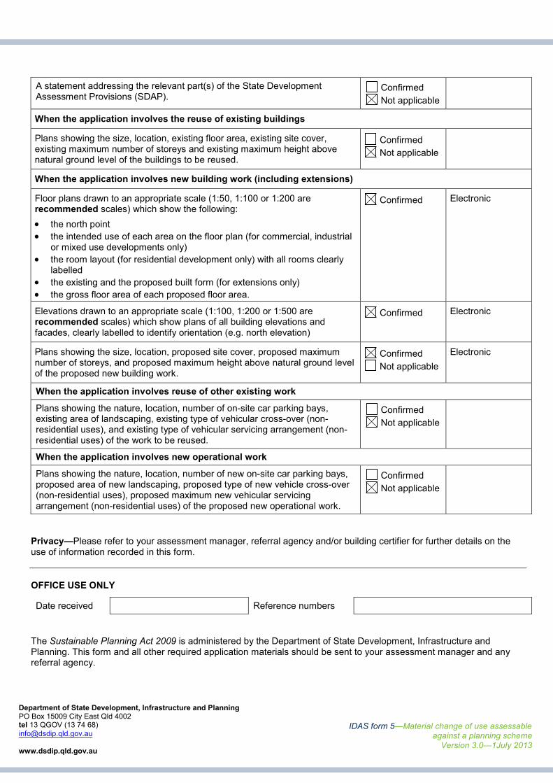
A statement addressing the relevant part(s) of the State DevelopmentAssessment Provisions (SDAP).
Confirmed
Not applicable
When the application involves the reuse of existing buildings
Plans showing the size, location, existing floor area, existing site cover,existing maximum number of storeys and existing maximum height abovenatural ground level of the buildings to be reused.
Confirmed
Not applicable
When the application involves new building work (including extensions)
Floor plans drawn to an appropriate scale (1:50, 1:100 or 1:200 arerecommended scales) which show the following:
• the north point
• the intended use of each area on the floor plan (for commercial, industrialor mixed use developments only)
• the room layout (for residential development only) with all rooms clearlylabelled
• the existing and the proposed built form (for extensions only)
• the gross floor area of each proposed floor area.
Confirmed Electronic
Elevations drawn to an appropriate scale (1:100, 1:200 or 1:500 arerecommended scales) which show plans of all building elevations andfacades, clearly labelled to identify orientation (e.g. north elevation)
Confirmed Electronic
Plans showing the size, location, proposed site cover, proposed maximumnumber of storeys, and proposed maximum height above natural ground levelof the proposed new building work.
Confirmed
Not applicable
Electronic
When the application involves reuse of other existing work
Plans showing the nature, location, number of on-site car parking bays,existing area of landscaping, existing type of vehicular cross-over (non-residential uses), and existing type of vehicular servicing arrangement (non-residential uses) of the work to be reused.
Confirmed
Not applicable
When the application involves new operational work
Plans showing the nature, location, number of new on-site car parking bays,proposed area of new landscaping, proposed type of new vehicle cross-over(non-residential uses), proposed maximum new vehicular servicingarrangement (non-residential uses) of the proposed new operational work.
Confirmed
Not applicable
Privacy—Please refer to your assessment manager, referral agency and/or building certifier for further details on theuse of information recorded in this form.
OFFICE USE ONLY
Date received Reference numbers
The Sustainable Planning Act 2009 is administered by the Department of State Development, Infrastructure andPlanning. This form and all other required application materials should be sent to your assessment manager and anyreferral agency.

Appendix D
Planning Scheme Assessment Tables

Appendix D - House Code Page 1 of 1 244 Cliftonville Road, SarinaSarina Shire Planning Scheme 2005 14272
Response column key: Complies / AchievedA/S Alternative solutionN/A Not applicable
House Code
HOUSE CODE
Specific Outcomes Probable Solutions Response Comment
SO1 Development maintains local residential characterand amenity.
PS1.1 Building height does not exceed 8.5m; and CompliesThe proposed house will not exceed 8.5m in building height.Compliance is achieved.
PS1.2 Site cover of a house and associated outbuildings does not exceed 50%;and
CompliesThe site cover of the house does not exceed 50%.Compliance is achieved.
PS1.3 Outbuildings have a floor area equal to or less than:
(i) 60m2 in the Village Zone and the Residential and Tourist Residential
Precincts of the Town Zone; and
(ii) 110m2 in the Rural Residential Zone on lots with an area of 4000m2 or
less; and
N/A Not ApplicableThe application does not involve any outbuildings.
PS1.4 House is set back 6m from the road frontage. Where on a cornerallotment, or with two street frontages, the setback from the principal roadfrontage is 6m and 4.5m setback to the secondary road frontage. The same roadsetback distances apply to all outbuildings; and
CompliesThe proposed site of the house complies with the relevant setback requirementsoutlined in PS1.4.Compliance is achieved.
PS1.5 House is separated from buildings, structures and other confined areasused for intensive animal industries by at least 400m; and
CompliesThe house location is separated from any buildings, structures and other confinedareas used for intensive animal industries by more than 400m.Compliance is achieved.
PS1.6 House is set back 20m from any Rail Line as identified on Overlay MapMTEC1 where the House is located in the Rural or Rural Residential Zones.
CompliesThe proposed site of the house is set back further than 20m from any Rail Line.Compliance is achieved.
SO2 Buildings and structures are located to minimiseimpacts from natural disasters including flooding andbushfires.
PS2.1 Buildings and structures are constructed at least 0.3m above 5.0AHD incoastal communities in the Town Zone as identified on Zoning Map ZM3 and theVillage Zone on Zoning Maps ZM1c, ZM1d & ZM1e or 0.3m above the 100 YearARI (including 100 Year ARI and 50 Year ARI) identified on Overlay MapNHOM3 or 0.3m above the 1 in 100 year flood event for other parts of the Shire.
N/A Not ApplicableThe subject site is not located within a coastal community. PS2.1 is not applicableto the application.
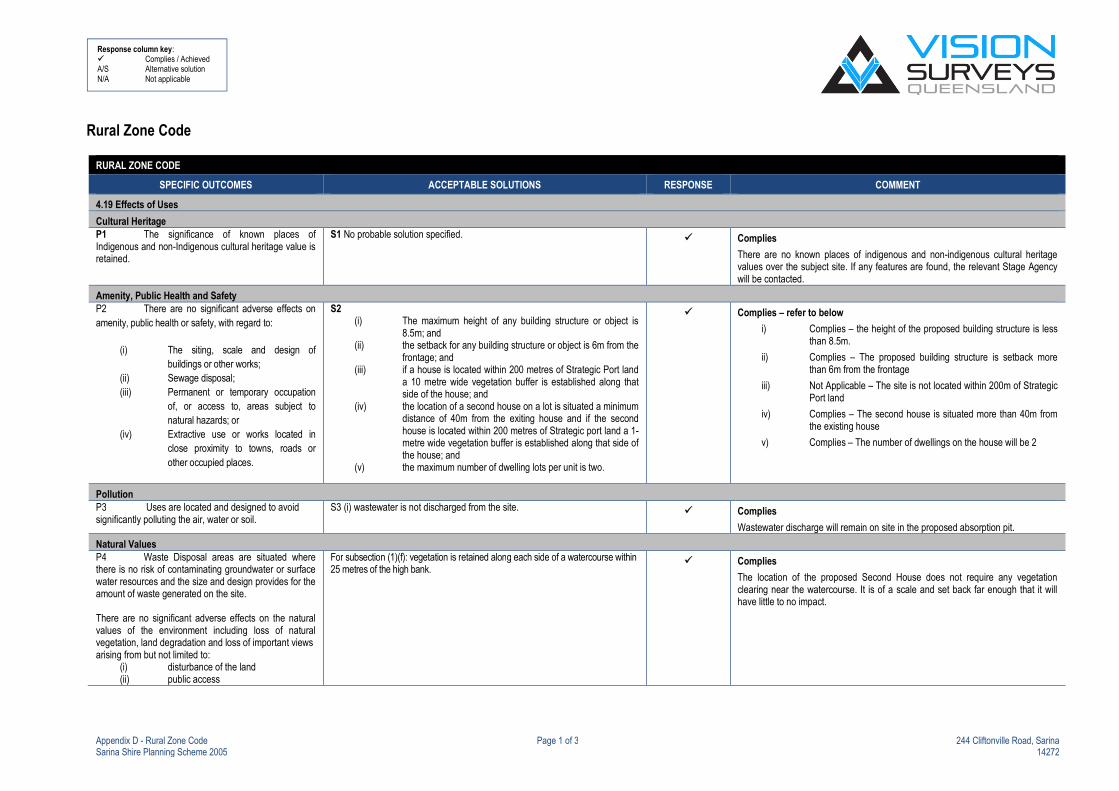
Appendix D - Rural Zone Code Page 1 of 3 244 Cliftonville Road, SarinaSarina Shire Planning Scheme 2005 14272
Response column key: Complies / AchievedA/S Alternative solutionN/A Not applicable
Rural Zone Code
RURAL ZONE CODE
SPECIFIC OUTCOMES ACCEPTABLE SOLUTIONS RESPONSE COMMENT
4.19 Effects of Uses
Cultural HeritageP1 The significance of known places ofIndigenous and non-Indigenous cultural heritage value isretained.
S1 No probable solution specified. Complies
There are no known places of indigenous and non-indigenous cultural heritagevalues over the subject site. If any features are found, the relevant Stage Agencywill be contacted.
Amenity, Public Health and SafetyP2 There are no significant adverse effects on
amenity, public health or safety, with regard to:
(i) The siting, scale and design of
buildings or other works;
(ii) Sewage disposal;
(iii) Permanent or temporary occupation
of, or access to, areas subject to
natural hazards; or
(iv) Extractive use or works located in
close proximity to towns, roads or
other occupied places.
S2(i) The maximum height of any building structure or object is
8.5m; and(ii) the setback for any building structure or object is 6m from the
frontage; and(iii) if a house is located within 200 metres of Strategic Port land
a 10 metre wide vegetation buffer is established along thatside of the house; and
(iv) the location of a second house on a lot is situated a minimumdistance of 40m from the exiting house and if the secondhouse is located within 200 metres of Strategic port land a 1-metre wide vegetation buffer is established along that side ofthe house; and
(v) the maximum number of dwelling lots per unit is two.
Complies – refer to below
i) Complies – the height of the proposed building structure is lessthan 8.5m.
ii) Complies – The proposed building structure is setback morethan 6m from the frontage
iii) Not Applicable – The site is not located within 200m of StrategicPort land
iv) Complies – The second house is situated more than 40m fromthe existing house
v) Complies – The number of dwellings on the house will be 2
PollutionP3 Uses are located and designed to avoidsignificantly polluting the air, water or soil.
S3 (i) wastewater is not discharged from the site. Complies
Wastewater discharge will remain on site in the proposed absorption pit.
Natural ValuesP4 Waste Disposal areas are situated wherethere is no risk of contaminating groundwater or surfacewater resources and the size and design provides for theamount of waste generated on the site.
There are no significant adverse effects on the naturalvalues of the environment including loss of naturalvegetation, land degradation and loss of important viewsarising from but not limited to:
(i) disturbance of the land(ii) public access
For subsection (1)(f): vegetation is retained along each side of a watercourse within25 metres of the high bank.
Complies
The location of the proposed Second House does not require any vegetationclearing near the watercourse. It is of a scale and set back far enough that it willhave little to no impact.

Appendix D - Rural Zone Code Page 2 of 3 244 Cliftonville Road, SarinaSarina Shire Planning Scheme 2005 14272
Response column key: Complies / AchievedA/S Alternative solutionN/A Not applicable
RURAL ZONE CODE
SPECIFIC OUTCOMES ACCEPTABLE SOLUTIONS RESPONSE COMMENT
(iii) fire hazard(iv) siting of buildings and other works; or(v) waste disposal
Watercourses and adjacent habitat are protected bymaintaining bank stability against erosion and slumping,maintaining water quality by filtering sediment nutrientsand other pollutants and maintaining aquatic and wildlifehabitat.
The use and values of national parks conservation parksand resource reserves including State Forests andTimber Reserves are protected
4.20 Provision of Effects of Uses
Provision of WorksP5 (a) Filling or excavation:
(i) Is of a suitable standard for the long termstability and
performance of the use;
(ii) maintains the visual amenity of the surrounding area;
(iii) maintains the environmental values of the receiving
waterways;
(iv) maintains the existing drainage paths includingoverland flow paths; and
(v) ensures the site area and adjacent land is free fromponding unless this is required as part of anapproved use.
S5Filling or excavation works are constructed to standards stated in planningscheme policies 7 and 11 and the site is not on the contaminated land register.
N/A Not Applicable
There is no filling or excavation proposed.
Provision of Design of Water Supply, Sewerage and RoadsP6 (b) Water supply, sewerage and roads areprovided to:(i) meet appropriate standards at the least whole of-
life cost, including avoiding unnecessaryduplication;
(ii) be robust and fit for the purpose and intendedperiod of operation;
(iii) be easily maintained with limited use of specialistexpertise or equipment required;
(iv) be comprised of components and materials that arereadily accessible and available from numerouslocal sources; and
(v) be readily integrated with existing systems andfacilitate the orderly provision of future systems.
For subsection (1) (b) – roads, water supply and sewerage works areconstructed to standards stated in planning scheme policies 4, 6, 8, 9 and 11.Where connected to Council’s reticulated water supply and sewerage scheme,contributions are made to Council to the standards stated in planning schemepolicy 10. Where not connected to Council’s reticulated water supply, a potablewater supply is provided to standards described in planning scheme policy 8,appendix 8.1
Complies
Water supply will be via water tanks and the usage of a bore. Sewerage will beachieved via an onsite effluent disposal system.

Appendix D - Rural Zone Code Page 3 of 3 244 Cliftonville Road, SarinaSarina Shire Planning Scheme 2005 14272
Response column key: Complies / AchievedA/S Alternative solutionN/A Not applicable
RURAL ZONE CODE
SPECIFIC OUTCOMES ACCEPTABLE SOLUTIONS RESPONSE COMMENT
Design of RoadsP7 (c) The safe and efficient operation of roads
are maintained having regard to:
(i) the location and design of access points;
(ii) the design of stormwater drainage;
(iii) impacts on any new use through the effects of noiseand dust resulting from the use of the road; and
(iv) roads are upgraded to accommodate impacts.
S7 Vehicular access is designed and constructed to the standards stated inplanning scheme policy 5, with a slope of not greater than 1:5, to maintainexisting drainage paths and properly manage unsuitable soil types.Contributions are made to Council for the upgrading or roads external to the siteto the standards stated in planning scheme policy 12.
Complies
Internal access road will be constructed to access from existing Easements.
Provision of Design of Vehicle Parking(d) On-site parking accommodated the number
and nature of vehicles required to service uses on the
site.
(e) Driveways turning areas parking and vehicle
standing areas designed constructed and maintained
such that :
(i) the gradient is suitable for vehicle
parking;
(ii) it is effectively drained and sealed;
(iii) spaces are clearly marked and signed
as appropriate; and
(iv) conflicts are minimised and public
safety maximised.
On-site parking is provided to standards stated in schedule 3, part 2. Where on-site parking cannot be provided, contributions are made to Council to thestandards stated in planning scheme policy 13.
Driveways, turning areas, parking and vehicle standing areas are provided tostandards stated in schedule 3, part 1 and planning scheme policies 5 and 11.
Complies
On site car parking will comply with Schedule 3 in the Planning Scheme.
Turn ways and driveways will be in accordance with the relevant standard.

Economic Resources Overlay Code
Specific Outcomes Probable Solutions Response Comment
SO1 Material change of use and reconfiguring a
lot does not reduce the utility and productive
capacity of good quality agricultural land and;
buildings and uses on lots adjoining good quality
agricultural land are located so as to minimise any
conflict arising from incompatible land uses.
PS1.1 Lot boundaries relate to natural features such as
ridges or other catchment boundaries, drainage lines or flood
flows, or remnant stands of vegetation; and
N/A Not ApplicableThe allotment boundaries are not being altered as a result of theproposal.
PS1.2 The minimum lot size is equal to or greater than80ha in the Rural Zone identified on Map ZM 1;
OR
A proposed lot is smaller than 80ha, and the reconfiguration isa boundary rearrangement that would not create anyadditional lots, would improve the relationship of the lots tonatural features, and
(i) any new lot to be primarily used for a dwelling unit and
ancillary buildings are buffered from Good Quality
Agricultural Land in accordance with Table 2: Summary of
buffer area design Criteria of Planning Guideline:
Separating Agricultural and Residential Land Uses
(DNRM & DLGP);
(ii) any new lot to be primarily used for a dwelling unit and
ancillary buildings contain buffers described in (i) above
and do not contain areas of Good Quality Agricultural
Land;(iii) access to any new lot to be primarily used for a dwelling
unit and ancillary buildings does not compromise theutility of Good Quality Agricultural Land; and
(iv) any lot comprising the balance area of the boundaryrearrangement has a minimum area of 40ha and aregular boundary configuration; and
N/A Not ApplicableThe application is not for a Reconfiguration of a Lot. The buildingfootprint is mapped as having GQAL over it and it is not consideredthe GQAL mapping is close enough to warrant a landscape buffer.
Further – the second house will not be reducing the utility andproductive capacity of the existing GQAL on the subject site.
That being, compliance is considered to be achieved.
PS1.3 T h e use of a premise for aquaculture is not located on
land identified as good quality agricultural land.
N/A Not ApplicableThe proposed site location does not reside within the Good QualityAgricultural Overlay Map (EROM1).
SO2 Buildings and uses are located on land
containing construction materials if the building or
use concerned protects the potential for future
utilisation of these resources and; buildings and
uses on lots in proximity to construction material
resources are located so as to minimise any
constraint to the potential for future utilisation of
these resources and to minimise any conflict
arising from incompatible land uses.
PS2.1 Houses are separated from a site containing
construction material resources by at least 1000 m if the
resource is hard rock, or 250m otherwise.
N/A Not Applicable

Overlay Code Assessment 244 Cliftonville Rd, Sarina
Sarina Shire Planning Scheme 2005 August 2014 | 14272

Overlay Code Assessment 244 Cliftonville Rd, Sarina
Sarina Shire Planning Scheme 2005 August 2014 | 14272
Natural Hazard Management Areas Overlay Code
Specific Outcomes Probable Solutions Response Comment
Element (i): Lot Layout And Safety
SO1 Development maintains the safety of
people and property by:
(a) avoiding areas of High or Medium
bushfire hazard; or
(b) mitigating the risk through:
lot design and the siting ofbuildings; and
including firebreaks that provide
adequate setbacks
buildings/structures and hazardous
vegetation and; access for fire
fighting and other emergency
vehicles;
providing adequate road access for
fire fighting and other emergency
vehicles and safe evacuation; and
providing an adequate and
accessible water supply for fire
fighting purposes.
PS1.1
The road layout provides for “through-roads” and does not
include cul-de-sac and “dead end” roads (see Figure A).
N/A Not ApplicableThe lot layout is not being amended. There are no ‘through roadsproposed.
PS1.2 The solutions identified for specific outcome 1. Appendix5B, State Planning Policy 1/03 Guideline-Mitigating the AdverseImpacts of Flood, Bushfire and Landslide.
N/A Not ApplicableThe application is no increase the level of risk to people andproperty as per SO1. The provisions of SO1 are not consideredapplicable to the application though can be conditioned if requiredby Mackay Regional Council.
Figure A – From Bushfire Hazard Planning in Queensland 1998 (Rural Fire Service and Department of Local Government and Planning)
Overlay Code Assessment 244 Cliftonville Rd, Sarina
Sarina Shire Planning Scheme 2005 August 2014 | 14272
Specific Outcomes Probable Solutions Response Comment
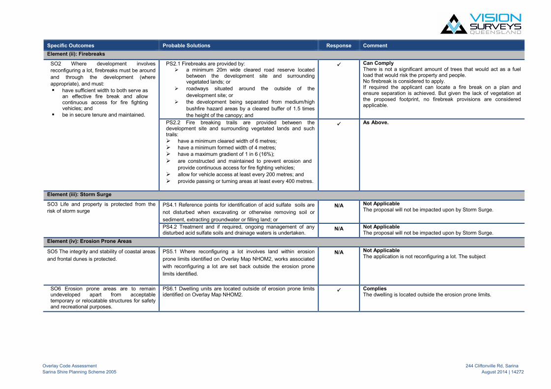
Element (ii): Firebreaks
SO2 Where development involves
reconfiguring a lot, firebreaks must be around
and through the development (where
appropriate), and must:
have sufficient width to both serve asan effective fire break and allowcontinuous access for fire fightingvehicles; and
be in secure tenure and maintained.
PS2.1 Firebreaks are provided by: a minimum 20m wide cleared road reserve located
between the development site and surroundingvegetated lands; or
roadways situated around the outside of the
development site; or
the development being separated from medium/high
bushfire hazard areas by a cleared buffer of 1.5 times
the height of the canopy; and
Can ComplyThere is not a significant amount of trees that would act as a fuelload that would risk the property and people.No firebreak is considered to apply.If required the applicant can locate a fire break on a plan andensure separation is achieved. But given the lack of vegetation atthe proposed footprint, no firebreak provisions are consideredapplicable.
PS2.2 Fire breaking trails are provided between thedevelopment site and surrounding vegetated lands and suchtrails: have a minimum cleared width of 6 metres;
have a minimum formed width of 4 metres; have a maximum gradient of 1 in 6 (16%);
are constructed and maintained to prevent erosion and
provide continuous access for fire fighting vehicles;
allow for vehicle access at least every 200 metres; and
provide passing or turning areas at least every 400 metres.
As Above.
Element (iii): Storm Surge
SO3 Life and property is protected from the
risk of storm surgePS4.1 Reference points for identification of acid sulfate soils are
not disturbed when excavating or otherwise removing soil or
sediment, extracting groundwater or filling land; or
N/A Not ApplicableThe proposal will not be impacted upon by Storm Surge.
PS4.2 Treatment and if required, ongoing management of anydisturbed acid sulfate soils and drainage waters is undertaken.
N/A Not ApplicableThe proposal will not be impacted upon by Storm Surge.
Element (iv): Erosion Prone Areas
SO5 The integrity and stability of coastal areas
and frontal dunes is protected.
PS5.1 Where reconfiguring a lot involves land within erosion
prone limits identified on Overlay Map NHOM2, works associated
with reconfiguring a lot are set back outside the erosion prone
limits identified.
N/A Not ApplicableThe application is not reconfiguring a lot. The subject
SO6 Erosion prone areas are to remainundeveloped apart from acceptabletemporary or relocatable structures for safetyand recreational purposes.
PS6.1 Dwelling units are located outside of erosion prone limitsidentified on Overlay Map NHOM2.
CompliesThe dwelling is located outside the erosion prone limits.

Overlay Code Assessment 244 Cliftonville Rd, Sarina
Sarina Shire Planning Scheme 2005 August 2014 | 14272

Overlay Code Assessment 244 Cliftonville Rd, Sarina
Sarina Shire Planning Scheme 2005 August 2014 | 14272
Conservation Areas Overlay Code
Specific Outcomes Probable Solutions Response Comment
SO1 The ecological values of remnant
vegetation, waterways and coastal areas are
maintained.
PS1.1 Remnant vegetation associated with waterways, wetlands
and aquatic habitats is retained; or Complies
The existing remnant vegetation on the subject site will be retained.The dwelling house will not impact upon the existing vegetation.
PS1.2 Where clearing of remnant vegetation is unavoidable,vegetation is rehabilitated along each side of a watercourse withinat least 25 metres of each high bank; or
N/A Not ApplicableThere is no clearing of remnant vegetation associated with theproposal
PS1.3 The site area50
is set back a minimum distance of:
100m from Highest Astronomical Tide for coastal
wetlands; or
50m from high bank for freshwater habitat;
Or
CompliesThe proposal is setback in accordance with the provisions in PS1.3.
PS1.4 Remnant vegetation within the minimum distancesidentified in PS 1.2 and PS 1.3 is retained; or
CompliesNo remnant vegetation is being impacted upon.Compliance is achieved.
PS1.5 Remnant vegetation, as identified on map COM 1, ismaintained where associated with a forestry use.
N/A Not ApplicableThe remnant vegetation on the subject site will not be maintained asa forestry use.
SO2 The ecological values of identified Areas
on Maps COM1 and COM2 are protected
and enhanced.
PS2.1In partial fulfilment of SO2 -
Turtle nesting areas and important wetlands are protected
from:
– lighting; and
– formal pedestrian or vehicular access.
N/A Not ApplicableThere is no impact to turtle nesting and important wetlands.
SO3 Networks of wildlife habitat are
maintained or enhanced.
PS3.1 Remnant vegetation and habitat areas including ecological
corridors are retained; or Complies
The existing remnant vegetation on the subject site is beingmaintained.
PS3.2 Where clearing of vegetation is unavoidable, theconfiguration of retained vegetation ensures:
(a) the viability and connectivity of ecological corridors
and habitat areas is maintained; and
(b) areas where development should not occur are
identified.
N/A Not ApplicableThere is no clearing of remnant vegetation.
SO4 Building envelopes are located on that
part of each lot which poses the least threat
to the conservation values of the site.
PS4.1 Building envelopes are located in:
(a) an already cleared area; or
(b) a disturbed area with little potential for
rehabilitation; or
(c) an area infected with noxious weeds;or
(d) an area 50m from important habitat and
corridors or other significant landscape features
(eg. Vegetation along waterways);
(e) close to an access road; and
Complies
The subject area for the second house is already cleared. The area
of the building envelope does not maintain any conservation value
and therefore will not need rehabilitation.
PS4.2 Where an approved building envelope exists, developmentoccurs within that approved building envelope; or
Complies
There is an existing building approval. The development will occur
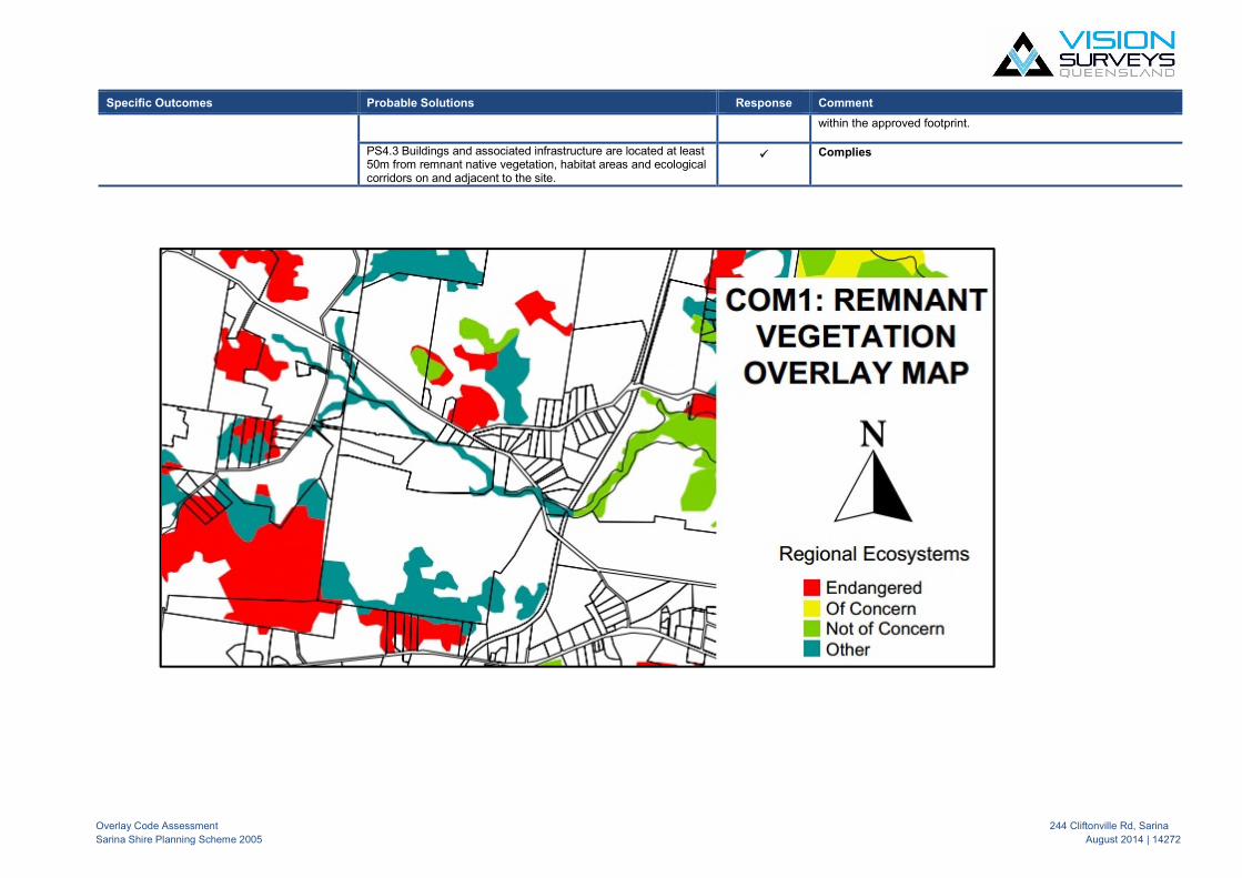
Overlay Code Assessment 244 Cliftonville Rd, Sarina
Sarina Shire Planning Scheme 2005 August 2014 | 14272
Specific Outcomes Probable Solutions Response Comment
within the approved footprint.
PS4.3 Buildings and associated infrastructure are located at least50m from remnant native vegetation, habitat areas and ecologicalcorridors on and adjacent to the site.
Complies

Appendix E
State Planning Policy 2014 (SPP) Mapping

Date: 30/06/20150 140 280 420 560
MetresDepartment of
Infrastructure, LocalGovernment and Planning ¢ Disclaimer:
This map has been prepared with due care based on the best available information at the time of publication. The State of Queensland holds no responsibility for any errors, inconsistencies or omissions within this document. Any decisions made by other parties based on this document are solely the responsibility of those parties. Please note whilst Bushfire Hazard Areas have not been triggered they may stil l apply.
State Planning Policy Local government development assessment
© The State of Queensland 2015.
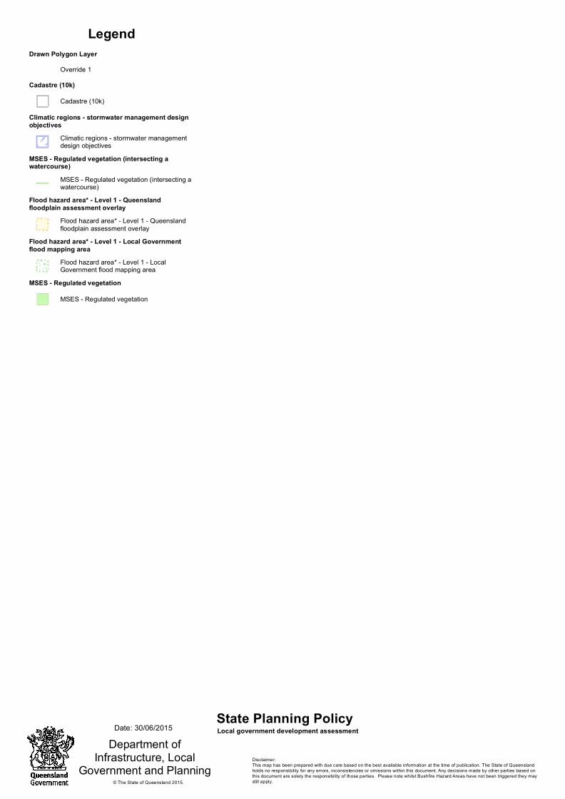
Department ofInfrastructure, Local
Government and Planning
LegendDrawn Polygon Layer
Override 1Cadastre (10k)
Cadastre (10k)
Climatic regions - stormwater management designobjectives
Climatic regions - stormwater managementdesign objectives
MSES - Regulated vegetation (intersecting awatercourse)
MSES - Regulated vegetation (intersecting awatercourse)
Flood hazard area* - Level 1 - Queenslandfloodplain assessment overlay
Flood hazard area* - Level 1 - Queenslandfloodplain assessment overlay
Flood hazard area* - Level 1 - Local Governmentflood mapping area
Flood hazard area* - Level 1 - LocalGovernment flood mapping area
MSES - Regulated vegetation
MSES - Regulated vegetation
State Planning Policy Local government development assessment
© The State of Queensland 2015.
Date: 30/06/2015
Disclaimer:This map has been prepared with due care based on the best available information at the time of publication. The State of Queensland holds no responsibility for any errors, inconsistencies or omissions within this document. Any decisions made by other parties based on this document are solely the responsibility of those parties. Please note whilst Bushfire Hazard Areas have not been triggered they may still apply.

Date: 30/06/20150 140 280 420 560
MetresDepartment of
Infrastructure, LocalGovernment and Planning ¢ Disclaimer:
This map has been prepared with due care based on the best available information at the time of publication. The State of Queensland holds no responsibility for any errors, inconsistencies or omissions within this document. Any decisions made by other parties based on this document are solely the responsibility of those parties. Please note whilst Bushfire Hazard Areas have not been triggered they may stil l apply.
State Planning Policy Local government development assessment
© The State of Queensland 2015.

Department ofInfrastructure, Local
Government and Planning
LegendDrawn Polygon Layer
Override 1Cadastre (10k)
Cadastre (10k)
Bushfire hazard area (Bushfire pronearea)
Very high (potential intensity)
High (potential intensity)
Medium (potential intensity)
Potential bushfire impact buffer
Potential bushfire impact buffer
State Planning Policy Local government development assessment
© The State of Queensland 2015.
Date: 30/06/2015
Disclaimer:This map has been prepared with due care based on the best available information at the time of publication. The State of Queensland holds no responsibility for any errors, inconsistencies or omissions within this document. Any decisions made by other parties based on this document are solely the responsibility of those parties. Please note whilst Bushfire Hazard Areas have not been triggered they may still apply.

Appendix F
Correspondence with Mackay Regional Council

1
Sean Brien
From: Shane Kleve <[email protected]>
Sent: Saturday, 11 April 2015 5:48 PM
To: 'Marcus Fossey'
Cc: Lee Glindemann
Subject: RE: Second House - Sarina Planning Scheme
Marcus, What you are suggesting has been done previously with similar requirements for the ‘first’ house to be constructed before the ‘second’ house. Any proposal for a second house on a lot will need to be accompanies by sufficient justification that the occupants will comply with the definition. Regards, Shane Shane Kleve | Acting Manager Development Assessment | Development Assessment | Mackay Regional Council Phone: 1300 MACKAY (622529) | Fax: 07 4944 2411 | [email protected] | mackay.qld.gov.au
PLEASE NOTE:
THE VIEWS EXPRESSED HERE ARE AN OFFICER'S OPINION BASED ON THE INFORMATION PROVIDED AND RELEVANT CURRENT POLICY AND LEGISLATION.
LODGEMENT OF A DEVELOPMENT APPLICATION IN THE FUTURE MAY RAISE OTHER ISSUES NOT CONSIDERED HERE AND THEREFORE THE ABOVE ADVICE DOES NOT BIND COUNCIL IN ANY WAY WHEN CONSIDERING A FUTURE DEVELOPMENT APPLICATION.
From: Marcus Fossey [mailto:[email protected]]
Sent: Tuesday, 7 April 2015 4:15 PM To: Shane Kleve
Cc: Lee Glindemann Subject: Second House - Sarina Planning Scheme
Hi Shane, Have a quick clarification for you. If a person has a current Building Approval to build a house within the Rural Zone, can they apply to have a ‘Second House’ under the Sarina Planning Scheme, although the previous house has not yet commenced building? Could Council condition a second house application to ensure the original dwelling is built prior to the second house.

2
I under the definition reads “means the use of premises for an additional house to an existing house on the same lot, where the second house is occupied by a relative or employee of the occupants of the existing house.” However could we apply for a second house although the current dwelling has not been constructed. Can you please assist? Thanks in advance. Marcus
Marcus Fossey Town Planner Vision Surveys (QLD) P: 07 4951 0768 | M: 0478 183 573 | E: [email protected] A: Level 1, 36 Wellington Street, Mackay | P: PO BOX 1730, MACKAY QLD 4740 | W: www.visionsurveysqld.com.au
Airlie Beach: U4, Gabriel Plaza, 55 Paluma Rd, Cannonvale PO Box 103, Airlie Beach Qld 4802 P: 07 4948 3781
Mackay: Level 1, 36 Wellington St, Mackay PO Box 1730, Mackay QLD 4740 P: 07 4951 0768
Rockhampton: 1 Denham Street, Rockhampton PO Box 1337, Rockhampton Qld 4700 P: 07 4927 1744
Townsville: Level 1, 167 Denham Street, Townsville PO Box 1444, Townsville QLD 4810 P: 07 4721 0410
Moranbah: 3 Griffin St, Moranbah PO Box 200, Moranbah QLD 4744 P: 07 4941 9069
This e-mail and any attachments to it are confidential and may contain legally privileged Information. Unless expressly authorised by the sender, you must not use, disseminate, copy or distribute the information contained in this e-mail. If you are not the intended recipient, you have received this communication in error. In that case, please delete all copies of the e-mail immediately and contact Vision Surveys either by return e-mail or phone (07) 4948 3781 � Please consider the environment before printing this e-mail
Disclaimer
This email and any attachments may contain confidential or privileged information. You must not use or
disclose this information, other than for the purposes for which it was supplied. The privilege or
confidentiality attached to this email and attachments is not waived by reason of mistaken delivery to you. If
for whatever reason this email is received by other than the intended recipient, you are requested to notify
the sender promptly by telephone, email or facsimile and destroy and delete all copies of the original
message.
Any personal information collected by Mackay Regional Council will be for lawful purposes directly
related to the functions of Council. Mackay Regional Council will take all reasonable precautions to respect
the privacy of individuals in accordance with the Information Privacy Act 2009 (Qld) and will protect the
personal information it holds from misuse, unauthorised access and modification.
Personal information will only be disclosed to a third party with your written authorisation or as required by
law.

Appendix G
Existing Building Approval for (‘first’) Dwelling House