Slum Redevelopment Scheme, Ward Number 196 Sudhar Camp.pdf · 2014-10-31 · Slum Redevelopment...
17
CITY LEVEL PROJECTS SUDHAR CAMP, KALKAJI Slum Redevelopment Scheme, Ward Number 196
Transcript of Slum Redevelopment Scheme, Ward Number 196 Sudhar Camp.pdf · 2014-10-31 · Slum Redevelopment...

CITY LEVEL PROJECTS
SUDHAR CAMP, KALKAJISlum Redevelopment Scheme, Ward Number 196

Delhi Urban Art Commission
Raj Rewal Chairman
Satish Khanna MemberSonali Bhagwati MemberEric P. Mall MemberD. Diptivilasa Member & Addl. Secretary, Ministry of Urban DevelopmentVinod Kumar Secretary
DUAC Staff
Rajeev Kumar Gaur, Raghvendra Singh, Amit Mukherji, V. K.Tyagi, Siddharth Sagar, Neelam Bhagat, Manju Anjali, Indu Rawat, Nihal Chand
Senior ConsultantDr. Aruna Ramani Grover
ConsultantsTanmay SaxenaAbhishek GauravKirti KawaleNikhil Pandey
Acknowledgements
It is said that for an artist to join establishment is a kiss of death. I was fully aware of this
aphorism when the Minister of Urban Development, Mr. Kamal Nath, asked me to be the
Chairman of the Delhi Urban Art Commission. I had three conditions before accepting
the assignment and one of these was that DUAC should be allowed to carry out site
specific studies for improving slums and unauthorized colonies. Subsequently, the Minister
along with the then Lieutenant Governor of Delhi, Mr. Tejendra Khanna, and Secretary,
Ministry of Urban Development, Dr. Sudhir Krishna, approved the proposal to carry out
three dimensional studies for improving slums and unauthorized colonies. I am grateful for
their support.
I would like to thank other members of the Commission, Eric P. Mall, Satish Khanna, Sonali
Bhagwati and D. Diptivilasa for helping to make success of problematic urban design
exercises and charting new paths.
I take this opportunity to thank senior consultants, architects, urbanists and planners as
well as younger colleagues who have been working full time. DUAC Secretary, Vinod
Kumar, and other permanent staff have enthusiastically supported us and guided us
through government procedures. Many thanks to all of them.
Raj Rewal Chairman
DELHI URBAN ART COMMISSION with gratitude duly acknowledges the valuable
contributions of the following Government organizations in making this report:
Ministry of Urban Development
Delhi Development Authority
Government of National Capital Territory of Delhi
North Delhi Municipal Corporation
East Delhi Municipal Corporation
South Delhi Municipal Corporation
New Delhi Municipal Council
Geospatial Delhi Limited
Delhi Metro Rail Corporation
Delhi Urban Shelter Improvement Board
BSES Rajdhani Power Limited
BSES Yamuna Power Limited
RWA’s and Area Councillors

Preface
Half of Delhi lives in ramshackle slums and shabby unauthorized colonies. This state of
affairs is a serious blot on the face of the city which has great historical monuments and
aspires to be a world class city. The centre of New Delhi is lined with leafy trees and can
boast of superb example of contemporary architecture but its growth under exploding
population has disintegrated into shanty towns.
My first memory of Delhi is that of a child going in a tonga from the railway station
to our government quarter in New Delhi around a square which became our home
for several years. The squares were built near Birla temple and when my father was
promoted in the government hierarchy, he was offered an independent house with a
larger area but my mother refused to move as she had developed kinship with families
around the square. This was my first lesson in neighbourhood “mohalla” as an urban
phenomenon.
In fact the word ‘urb’ in Latin stands for neighbourhood space. It was a period when
Connaught Place was the leisurely centre for social, shopping and cultural activities and
the Old Delhi was lively and still gracious, dominated by Jama Masjid and Red Fort. Delhi’s
monuments like Humayun’s Tomb, Qutab Minar and Lodhi Garden were favourite places
for picnics.
Seventy years have passed since the tonga ride, Delhi has dramatically changed as the
population of Delhi has exploded from under a million before partition in 1947 to about
twenty million today.
As a Professor in the School of Planning and Architecture in Delhi, I had ample scope
of studying typology of Indian cities which helped me to design Asian Games Village in my
mid-career around 1980 as a series of clusters (mohalla neighbourhood) woven around
pedestrian pathways, segregated from road networks. This was a low rise high density
housing built within the framework of 150 FAR (FSI 1.5).
Delhi has changed even more drastically during the last thirty years since the Asian
Games Village was built, but the idea of a city as a series of sympathetic, humane
interconnected neighbourhood building blocks interspersed with social, cultural and
educational facilities has remained embedded in my mind.
Delhi Urban Art Commission was established to preserve, develop and maintain the
aesthetic quality of urban and environmental design within Delhi. During the last 40 years
of its existence, DUAC has not received any three dimensional exercises which visualizes
neighbourhoods, wards etc. The emphasis has often been only appraising individual
buildings and complexes submitted through local municipal agencies. After taking over the
direction of DUAC in 2011, members of the Commission arranged meetings with wide
spectrum of advisors and formulated principles on which a building can be automatically
and speedily approved and decided to take over the job of visualization and three
dimensional planning for various aspects of the site specific designs which need to be
urgently developed if Delhi has to maintain standard as a world capital city.
A large part of Delhi lives in unauthorized colonies and slums and even the Master Plan
of Delhi had suggested a detailed design proposal to augment the Master Plan based on
ground realities.
In order to fulfil the requirements of neighbourhoods, wards, the DUAC has
undertaken a few pilot projects which can be eventually developed in a manner that the
local municipal agencies can implement them. In order to carry out these studies, DUAC
developed in its own office a core group of architects and urban planners. This was done
on the basis of DUAC mandate that “the Commission may suo motu promote and
secure the development, re-development of which no proposals in that behalf have been
received from any local body”.
The studies involve the visual tools for ground studies combined with extra assistance
of Google images. It is hoped that the proposals and their conclusions would be
evolved to such an extent that a process can be worked out with the resident welfare
associations to make meaningful designs for the neighbourhood upgradation for the
different kind of wards.
The DUAC’s site specific designs are the seeds which can grow and it is hoped that
economic principles would be evolved to implement the meaningful neighbourhood
upgradation for the different kind of slums and wards. India cannot remain shabby and
ramshackle forever and solutions have to be found for shanty towns.
Raj RewalChairman, DUAC
January 2014

Contents1 Slum Context 6 1.1 Location and Connectivity 7
1.2 MPd 2021 Requirements 8
1.3 Slum Livelihood Catchment 9
1.4 Existing Situations/Conditions 10
1.5 Social Infrastructure 12
1.6 development details 13
2 Design Proposal 14 2.1 design Option - 1 14 2.1.1 Site Plan 14 2.1.2 design Intent 15 2.1.3 Cluster Plans 15 2.1.4 Unit Plans 15 2.1.5 Typical Floor Plans 16 2.1.6 design details 16 2.1.7 Views 17
2.2 design Option - 2 20 2.2.1 Site Plan 20 2.2.2 design Intent 21 2.2.3 Cluster Plans 21 2.2.4 Unit Plans 21 2.2.5 Typical Floor Plans 22 2.2.6 design details 22 2.2.7 Views 23
3 Comparative Analysis 26 3.1 Comparative Analysis for Sudhar Camp 26
3.2 On design Intent 26
4 Future Direction and Recommendations 27 4.1 Future direction 27
4.2 Recommendations 27
Summary
As per Shelter Policy of MPD 2021, 50-55% of the 24 lakh additional dwelling units to
be provided in the plan period would be for the Urban Poor and economically weaker
sections in the form of houses of two rooms or less. In the existing slum settlements,
the threefold strategy of relocation from areas required for public purpose, in-situ up-
gradation and the interim measure of upgradation to minimum standards is to be followed.
Objective In keeping with the above framework the Delhi Urban Art Commission
has undertaken alternative site specific housing design options for one site,
i.e. Sudhar Camp which falls under the Municipal Ward No. 196.
Design Intent The intent was to explore low-rise housing options within the limits of the
site geometry and size.
Outcome Explorations have resulted in two alternative design options for in-situ
rehabilitation of the slum population of Sudhar Camp.
Results have also resulted in establishing some insight into the inter-
relationships of governing norms of FAR, density, ground coverage,
setback norms and appointment for commercial use.

Slu
m C
on
tex
t
6 CITY LEVEL ProjECT
Slu
m C
on
tex
t
7SUDHAr CAMP, KALKAjI
Sudhar Camp is located in between the ward boundaries of East of Kailash (Ward No. 194) and Kalkaji (Ward No. 196).
It is surrounded by a high-end residential area comprising plotted developments of minimum 500 sq m of area under each plot
It is connected with the Outer Ring Road on the west side, Ma Anandmai Marg on the east side and with a Metro link of the Violet Line which is at a distance of half-a-kilometre.
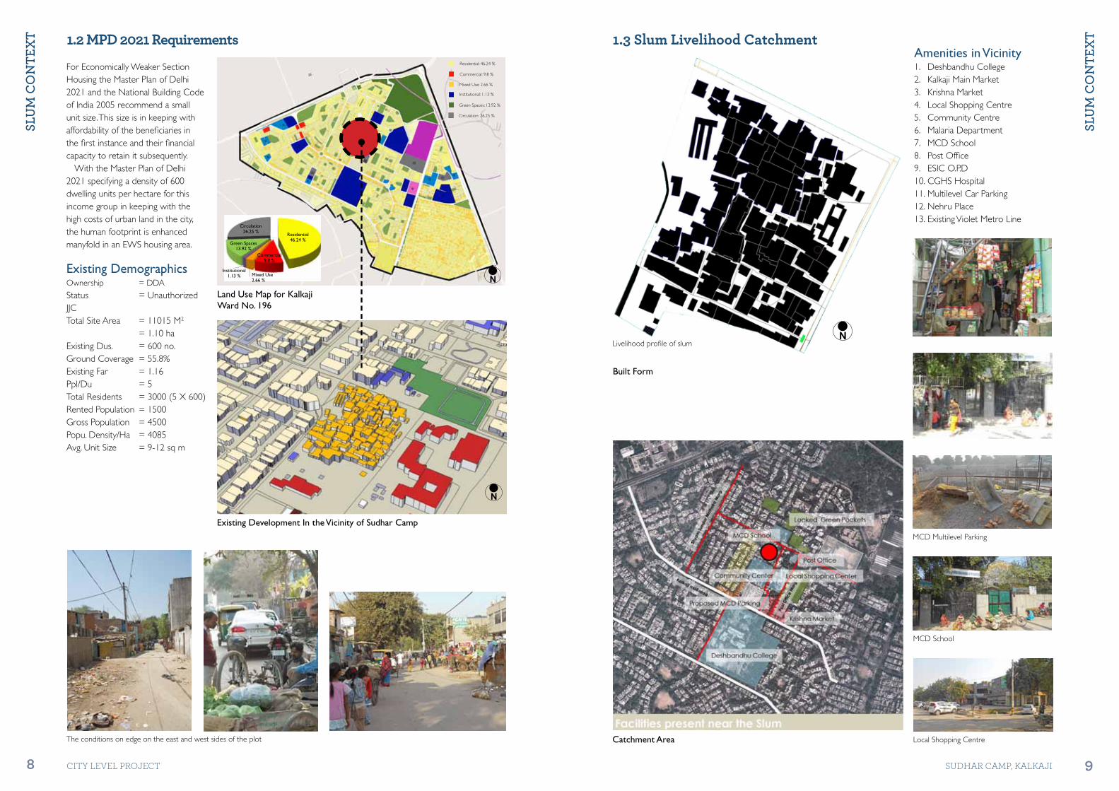
For Economically Weaker Section Housing, the Master Plan of Delhi 2021 and the National Building Code of India 2005 recommend a small unit size. This size is in keeping with affordability of the beneficiary in the first instance and their financial capacity to retain it subsequently.
With this income group it is the failure of the latter which pushes the head of the family to sell the house as a commodity in the market at every potential financial crunch. It is this lack of financial security that forces a family of 5 to 6 to live in a small shelter unit with a carpet area of 25 square metres.
This miniscule unit with four or five independent, internal spaces i.e. ,1–2 rooms, kitchen, bathroom/water closet and balcony requiring direct light and ventilation, implies a rather intricate spatial organization which has many interstitial open to sky spaces. It calls for a careful crafting of the built and the open.
When a family of 5-6, sometimes across 3 generations, is forced to live in 25 square metres of indoor area, the space immediately outside the unit becomes very valuable. Outdoor living and sleeping thereafter become a shear necessity, reinforced by the requirements of social and family structure. This calls for careful apportioning of common spaces around the unit.
Local Transport
N Road Network
1
3
2
4
N
Site
Outer Ring Road
Ma A
nandmaai Road
Gur
u Ra
vida
s M
arg
1
2
3
4
1.1 Location and Connectivity
1
2
3
4
Slu
m C
on
tex
t
8 CITY LEVEL ProjECT
Slu
m C
on
tex
t
9SUDHAr CAMP, KALKAjI
N
Existing Development In the Vicinity of Sudhar Camp
For Economically Weaker Section Housing the Master Plan of Delhi 2021 and the National Building Code of India 2005 recommend a small unit size. This size is in keeping with affordability of the beneficiaries in the first instance and their financial capacity to retain it subsequently.
With the Master Plan of Delhi 2021 specifying a density of 600 dwelling units per hectare for this income group in keeping with the high costs of urban land in the city, the human footprint is enhanced manyfold in an EWS housing area.
Existing DemographicsOwnership = DDA
Status = Unauthorized JJCTotal Site Area = 11015 M2 = 1.10 haExisting Dus. = 600 no.Ground Coverage = 55.8%Existing Far = 1.16Ppl/Du = 5Total Residents = 3000 (5 X 600)Rented Population = 1500Gross Population = 4500Popu. Density/Ha = 4085Avg. Unit Size = 9-12 sq m
Built Form
1.3 Slum Livelihood Catchment
Catchment AreaThe conditions on edge on the east and west sides of the plot Local Shopping Centre
MCD Multilevel Parking
MCD School
Amenities in Vicinity1. Deshbandhu College2. Kalkaji Main Market 3. Krishna Market4. Local Shopping Centre5. Community Centre6. Malaria Department7. MCD School8. Post Office9. ESIC O.P.D10. CGHS Hospital11. Multilevel Car Parking12. Nehru Place13. Existing Violet Metro Line
Livelihood profile of slumN
Land Use Map for Kalkaji Ward No. 196
N
Residential 46.24 %
Circulation 26.25 %
Green Spaces13.92 %
Commercial9.8 %
Mixed Use2.66 %
Institutional1.13 %
Mixed Use: 2.66 %
Institutional: 1.13 %
Green Spaces: 13.92 %
Circulation: 26.25 %
Residential: 46.24 %
Commercial: 9.8 %
1.2 MPD 2021 Requirements

Slu
m C
on
tex
t
10 CITY LEVEL ProjECT
Slu
m C
on
tex
t
11SUDHAr CAMP, KALKAjI
1.4 Existing Condition/Situations
ServicesThe camp has inadequate basic amenities like toilets, proper sewerage and other facilities. Moreover lack of proper maintenance is a major concern.
Open SpacesIn the absence of any public open spaces in the form of green areas or parks, residents block the peripheral roads and makeshift arrangements for community gatherings.
EdgeThe edge is characterized by unorganized informal markets overspilling on to the ROWs and drains.
Dwelling Unit (DUs) TypologyDU typologies were found, with number of floors reflecting the changing family needs of increasing number. In some cases additional floors were added to exploit the rentals it would bring in to enhance family income.
Parking & AccessibilityOn-road parking for scooters and cycle rickshaw encroach upon the pedestrian walking areas and ROWs. Connectivity by public transport also is an issue with people walking to the main road for travelling.
StructureMixed varieties of built conditions have been observed as per site conditions depending upon the needs. Though the construction is restricted within a boundary wall by local bodies, yet a temporary extension can be seen on all the sides of the site. Ladders are used to climb to the upper floors due to lack of space for constructing a common staircase, which could have been shared by a group of dwelling units.
Built ConditionsA maximum of G+2 structures with several issues which needs to be taken care of. The average street widths vary from 0.75 m to 1.0 m
RoofingAluminium/asbestos sheets for single storey and G.I. sections with local red sandstone slabs for G+1 structures respectively, were the types of roofing conditions which have been spotted in the residential dwelling units. Use of RCC slabs were also seen for some newly constructed buildings (temple shelters).
5
9
3
7
1
2
6
4
8
N
97
6
8
1
2
3
4
5
Slu
m C
on
tex
t
12 CITY LEVEL ProjECT
Slu
m C
on
tex
t
13SUDHAr CAMP, KALKAjI
N
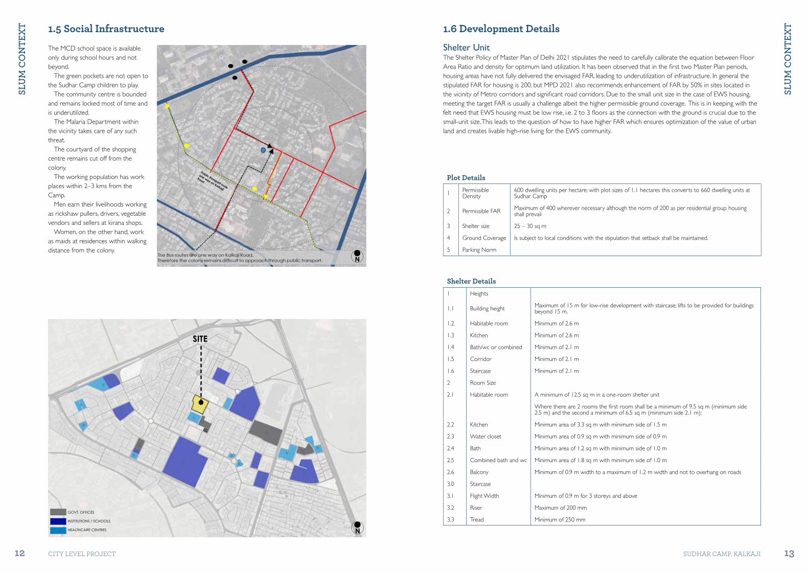
The MCD school space is available only during school hours and not beyond.
The green pockets are not open to the Sudhar Camp children to play.
The community centre is bounded and remains locked most of time and is underutilized.
The Malaria Department within the vicinity takes care of any such threat.
The courtyard of the shopping centre remains cut off from the colony.
The working population has work places within 2–3 kms from the Camp.
Men earn their livelihoods working as rickshaw pullers, drivers, vegetable vendors and sellers at kirana shops.
Women, on the other hand, work as maids at residences within walking distance from the colony.
1.6 Development Details
Plot Details
1 Permissible Density
600 dwelling units per hectare; with plot sizes of 1.1 hectares this converts to 660 dwelling units at Sudhar Camp
2 Permissible FAR Maximum of 400 wherever necessary although the norm of 200 as per residential group housing shall prevail
3 Shelter size 25 – 30 sq m
4 Ground Coverage Is subject to local conditions with the stipulation that setback shall be maintained.
5 Parking Norm
Shelter Details1 Heights
1.1 Building height Maximum of 15 m for low-rise development with staircase; lifts to be provided for buildings beyond 15 m.
1.2 Habitable room Minimum of 2.6 m
1.3 Kitchen Minimum of 2.6 m
1.4 Bath/wc or combined Minimum of 2.1 m
1.5 Corridor Minimum of 2.1 m
1.6 Staircase Minimum of 2.1 m
2 Room Size
2.1 Habitable room A minimum of 12.5 sq m in a one-room shelter unit
Where there are 2 rooms the first room shall be a minimum of 9.5 sq m (minimum side 2.5 m) and the second a minimum of 6.5 sq m (minimum side 2.1 m);
2.2 Kitchen Minimum area of 3.3 sq m with minimum side of 1.5 m
2.3 Water closet Minimum area of 0.9 sq m with minimum side of 0.9 m
2.4 Bath Minimum area of 1.2 sq m with minimum side of 1.0 m
2.5 Combined bath and wc Minimum area of 1.8 sq m with minimum side of 1.0 m
2.6 Balcony Minimum of 0.9 m width to a maximum of 1.2 m width and not to overhang on roads
3.0 Staircase
3.1 Flight Width Minimum of 0.9 m for 3 storeys and above
3.2 Riser Maximum of 200 mm
3.3 Tread Minimum of 250 mmGOVT. OFFICES
INSTITUTIONS / SCHOOLS
HEALTHCARE CENTRES N
SITE
Shelter UnitThe Shelter Policy of Master Plan of Delhi 2021 stipulates the need to carefully calibrate the equation between Floor Area Ratio and density for optimum land utilization. It has been observed that in the first two Master Plan periods, housing areas have not fully delivered the envisaged FAR, leading to underutilization of infrastructure. In general the stipulated FAR for housing is 200, but MPD 2021 also recommends enhancement of FAR by 50% in sites located in the vicinity of Metro corridors and significant road corridors. Due to the small unit size in the case of EWS housing, meeting the target FAR is usually a challenge albeit the higher permissible ground coverage. This is in keeping with the felt need that EWS housing must be low rise, i.e. 2 to 3 floors as the connection with the ground is crucial due to the small-unit size. This leads to the question of how to have higher FAR which ensures optimization of the value of urban land and creates livable high-rise living for the EWS community.
1.5 Social Infrastructure

PRo
PoSA
lS
14 CITY LEVEL ProjECT
PRo
PoSA
lS
15SUDHAr CAMP, KALKAjI
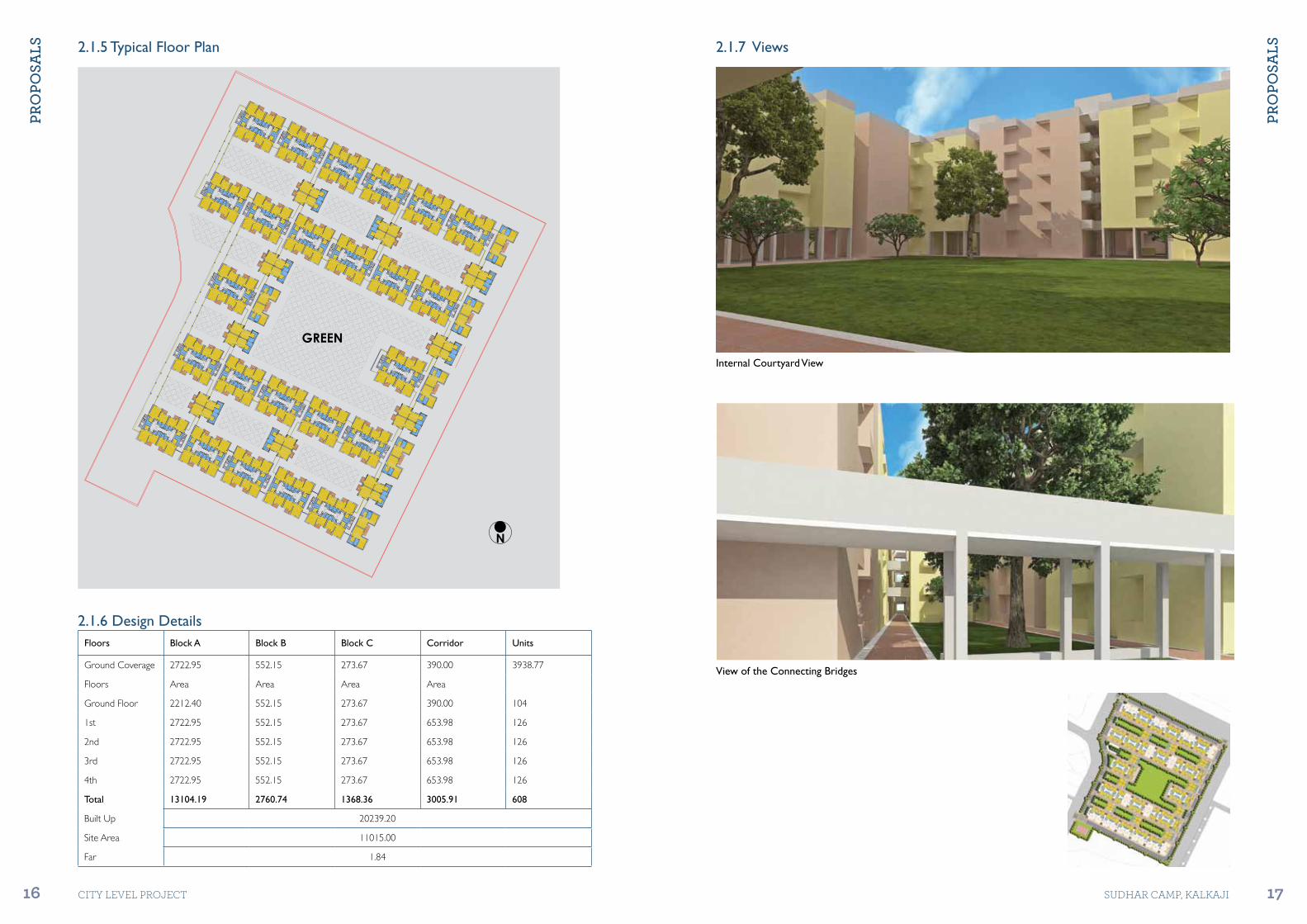
2.1.2 Design IntentIt is a low-rise built-form of ground and four floors where all units have two rooms with one room opening looking on to cluster level spaces.
The intention is to fulfil both the density and unit area norms to the degree possible.
While this has been achieved this scheme’s main area of dissatisfaction is that due to the plot size and geometry, it is neither possible to generate the community open space nor provide for any community facility.
A closer spatial analysis of the scheme indicates that almost 22% of the site area is lost to built-form development due to the peripheral setback of 6 m on all four sides.
If this area is somehow retrieved and reassembled into one open space all the needs of the community would be met.
In this Design Option, the strategy of providing only larger units in the scheme improves the FAR to a substantial degree.
Cluster level open spaces along with community green spaces are satisfactory.
The larger unit footprint ensures that community open space is reduced to just the peripheral setbacks which are used in this gated community as a peripheral road with access to parking under stilts.
N
GREEN
2.1 Design Option 1
2.1.1 Site Plan
Design Details1 Total number of units 608 units
2 Residential density achieved 552 DU per hectare
3 Floor Area Ratio 184
4 Ground coverage achieved 35.75%
5 Unit details 3 types of units with plinth area ranging between 21 to 30 sqm
6 Area under parking 1,780 sq m
7 Amenities on site Multipurpose hall (area 350 sq m), open community green (area 2505 sq m), 6 shops
Type -APlinth Area : 30.0 sq m.Carpet Area : 22.5 sq m.
Type -BPlinth Area : 27.0 sq m.Carpet Area : 20.5 sq m.
Type -CPlinth Area : 28.5 sq m.Carpet Area : 21.4 sq m.
N
Type B
Type C
Type A
2.1.3 Cluster Plan
2.1.4 Unit Plans
PRo
PoSA
lS
16 CITY LEVEL ProjECT
PRo
PoSA
lS
17SUDHAr CAMP, KALKAjI
Internal Courtyard View
View of the Connecting Bridges
2.1.5 Typical Floor Plan 2.1.7 Views
GREEN
N
2.1.6 Design DetailsFloors Block A Block B Block C Corridor Units
Ground Coverage 2722.95 552.15 273.67 390.00 3938.77
Floors Area Area Area Area
Ground Floor 2212.40 552.15 273.67 390.00 104
1st 2722.95 552.15 273.67 653.98 126
2nd 2722.95 552.15 273.67 653.98 126
3rd 2722.95 552.15 273.67 653.98 126
4th 2722.95 552.15 273.67 653.98 126
Total 13104.19 2760.74 1368.36 3005.91 608
Built Up 20239.20
Site Area 11015.00
Far 1.84

PRo
PoSA
lS
18 CITY LEVEL ProjECT
PRo
PoSA
lS
19SUDHAr CAMP, KALKAjI
Bird’s-Eye View

PRo
PoSA
lS
20 CITY LEVEL ProjECT
PRo
PoSA
lS
21SUDHAr CAMP, KALKAjI
Type -APlinth Area : 28.5 sq mCarpet Area : 21.5 sq m
Type -BPlinth Area : 25.0 sq mCarpet Area : 18.7 sq m
N
GREEN
Type -B
Type -A
N
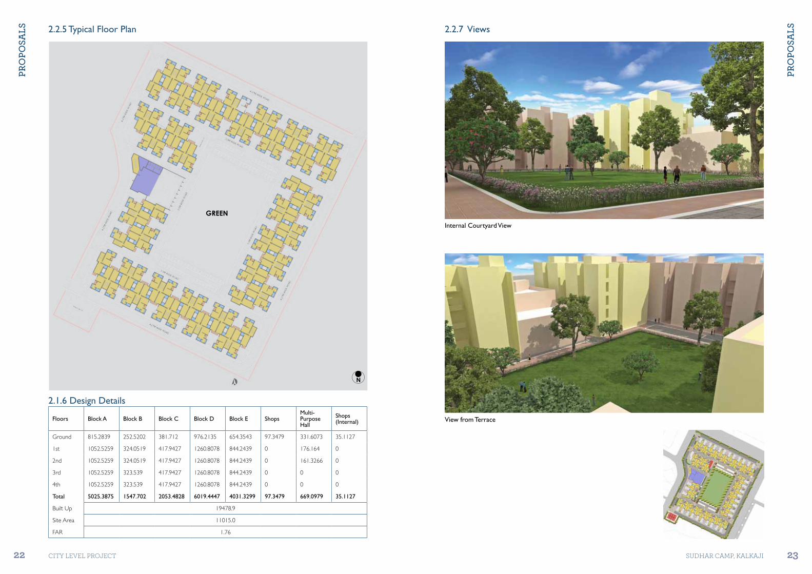
2.2.2 Design IntentIn the process of creating a low-rise built-form option this design takes cognizance of three aspects of the existing slum settlement in Sudhar Camp:•Theaveragesizeoftheexisting
units is in the range of 9 to 12 sq m. •Asmuchas33%oftheslum
population is living on rent.•Thewomenarecurrentlyusing
the single room space for daily bath and the community toilet for defecation
In this design option of ground and four floors, two types of units have been created to form a block which intertwines to create the cluster.
The morphology of the block adjusts to carve out interstitial cluster spaces which allow for external openings, i.e. windows and balcony doors.
The clusters are arranged around a large community open space with a community hall placed on one of the longer faces.
The larger of the two units has two rooms while the smaller has a large multipurpose room.
This variation in typology takes cognizance not only of the possible variable affordability but also the need of the rental v/s owner population.
In Design Option 2, the development height is restricted to 15 m and all units have access both to open spaces at the ground as well as the terrace.
Living standards are likely to be far better than before. The introduction of a smaller shelter unit ensures a high residential density of 640 dwelling units per hectare while ensuring satisfactory block and community open spaces.
However, this strategy cuts back the FAR achieved which now stands at 177, well short of the reccommended figure of 200, a condition which implies underutilization of urban land from the city point of view.
2.2 Design Option 2
2.2.1 Site Plan
Design Details1 Total number of units 705 units
2 Residential density achieved 640 DU per hectare
3 Floor Area Ratio 177
4 Ground coverage achieved 40.5%
5 Unit details Smaller unit of 21 sq m and larger unit of 28.5 sq m
6 Area under parking 2960 sq m
7 Amenities on site Multilevel community building (area 670 sq m), Open community green (area 1443 sq m), 8 large shops and 3 small shops
2.2.3 Cluster Plan
2.2.4 Unit Plans
PRo
PoSA
lS
22 CITY LEVEL ProjECT
PRo
PoSA
lS
23SUDHAr CAMP, KALKAjI
N
N
GREEN
Internal Courtyard View
View from Terrace
2.2.5 Typical Floor Plan 2.2.7 Views
2.1.6 Design Details
Floors Block A Block B Block C Block D Block E ShopsMulti-Purpose Hall
Shops (Internal)
Ground 815.2839 252.5202 381.712 976.2135 654.3543 97.3479 331.6073 35.1127
1st 1052.5259 324.0519 417.9427 1260.8078 844.2439 0 176.164 0
2nd 1052.5259 324.0519 417.9427 1260.8078 844.2439 0 161.3266 0
3rd 1052.5259 323.539 417.9427 1260.8078 844.2439 0 0 0
4th 1052.5259 323.539 417.9427 1260.8078 844.2439 0 0 0
Total 5025.3875 1547.702 2053.4828 6019.4447 4031.3299 97.3479 669.0979 35.1127
Built Up 19478.9
Site Area 11015.0
FAR 1.76

PRo
PoSA
lS
24 CITY LEVEL ProjECT
PRo
PoSA
lS
25SUDHAr CAMP, KALKAjI
Bird’s-Eye View
Co
mPA
RAti
ve
An
Aly
SiS
26 CITY LEVEL ProjECT
Futu
Re D
iReC
tio
n A
nD
ReC
om
men
DAt
ion
S
27SUDHAr CAMP, KALKAjI
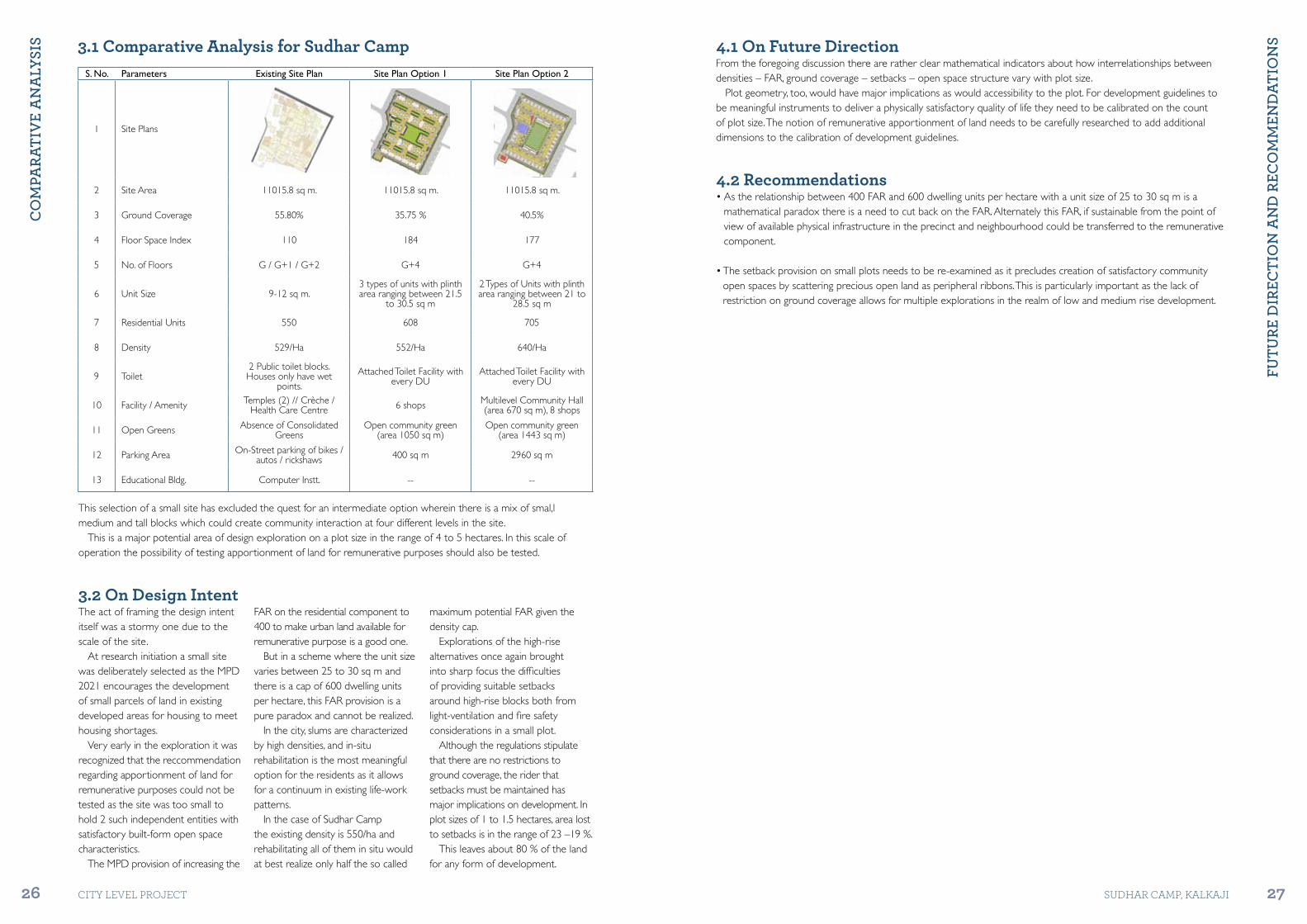
S. No. Parameters Existing Site Plan Site Plan Option 1 Site Plan Option 2
1 Site Plans
2 Site Area 11015.8 sq m. 11015.8 sq m. 11015.8 sq m.
3 Ground Coverage 55.80% 35.75 % 40.5%
4 Floor Space Index 110 184 177
5 No. of Floors G / G+1 / G+2 G+4 G+4
6 Unit Size 9-12 sq m.3 types of units with plinth area ranging between 21.5
to 30.5 sq m
2 Types of Units with plinth area ranging between 21 to
28.5 sq m
7 Residential Units 550 608 705
8 Density 529/Ha 552/Ha 640/Ha
9 Toilet2 Public toilet blocks. Houses only have wet
points.
Attached Toilet Facility with every DU
Attached Toilet Facility with every DU
10 Facility / Amenity Temples (2) // Crèche / Health Care Centre 6 shops Multilevel Community Hall
(area 670 sq m), 8 shops
11 Open Greens Absence of Consolidated Greens
Open community green (area 1050 sq m)
Open community green (area 1443 sq m)
12 Parking Area On-Street parking of bikes / autos / rickshaws 400 sq m 2960 sq m
13 Educational Bldg. Computer Instt. -- --
4.1 On Future DirectionFrom the foregoing discussion there are rather clear mathematical indicators about how interrelationships between densities – FAR, ground coverage – setbacks – open space structure vary with plot size.
Plot geometry, too, would have major implications as would accessibility to the plot. For development guidelines to be meaningful instruments to deliver a physically satisfactory quality of life they need to be calibrated on the count of plot size. The notion of remunerative apportionment of land needs to be carefully researched to add additional dimensions to the calibration of development guidelines.
4.2 Recommendations•Astherelationshipbetween400FARand600dwellingunitsperhectarewithaunitsizeof25to30sqmisa
mathematical paradox there is a need to cut back on the FAR. Alternately this FAR, if sustainable from the point of view of available physical infrastructure in the precinct and neighbourhood could be transferred to the remunerative component.
•Thesetbackprovisiononsmallplotsneedstobere-examinedasitprecludescreationofsatisfactorycommunityopen spaces by scattering precious open land as peripheral ribbons. This is particularly important as the lack of restriction on ground coverage allows for multiple explorations in the realm of low and medium rise development.
3.1 Comparative Analysis for Sudhar Camp
This selection of a small site has excluded the quest for an intermediate option wherein there is a mix of smal,l medium and tall blocks which could create community interaction at four different levels in the site.
This is a major potential area of design exploration on a plot size in the range of 4 to 5 hectares. In this scale of operation the possibility of testing apportionment of land for remunerative purposes should also be tested.
3.2 On Design IntentThe act of framing the design intent itself was a stormy one due to the scale of the site.
At research initiation a small site was deliberately selected as the MPD 2021 encourages the development of small parcels of land in existing developed areas for housing to meet housing shortages.
Very early in the exploration it was recognized that the reccommendation regarding apportionment of land for remunerative purposes could not be tested as the site was too small to hold 2 such independent entities with satisfactory built-form open space characteristics.
The MPD provision of increasing the
FAR on the residential component to 400 to make urban land available for remunerative purpose is a good one.
But in a scheme where the unit size varies between 25 to 30 sq m and there is a cap of 600 dwelling units per hectare, this FAR provision is a pure paradox and cannot be realized.
In the city, slums are characterized by high densities, and in-situ rehabilitation is the most meaningful option for the residents as it allows for a continuum in existing life-work patterns.
In the case of Sudhar Camp the existing density is 550/ha and rehabilitating all of them in situ would at best realize only half the so called
maximum potential FAR given the density cap.
Explorations of the high-rise alternatives once again brought into sharp focus the difficulties of providing suitable setbacks around high-rise blocks both from light-ventilation and fire safety considerations in a small plot.
Although the regulations stipulate that there are no restrictions to ground coverage, the rider that setbacks must be maintained has major implications on development. In plot sizes of 1 to 1.5 hectares, area lost to setbacks is in the range of 23 –19 %.
This leaves about 80 % of the land for any form of development.