SLT Draft Environmental Document Available for Review
7
1 Project No. 10-23 KA-3634-01 │Spring 2021 • Add two lanes to SLT to create a four-lane divided highway. • Build an interchange at 27th and Wakarusa. The traffic signal will be removed and access to the local streets will be provided via new interchange ramps. New bridges will carry SLT traffic over Wakarusa, allowing local traffic, bicyclists, and pedestrians to cross SLT safely. • Reconfigure the interchange ramps at I-70 and SLT to allow traffic to move easily from SLT to I-70. The reconfiguration will keep and improve access to and from Farmer’s Turnpike to SLT & I-70. • Realign SLT through the Clinton Parkway interchange to make the existing curve less sharp. • Reconfigure the interchange at U.S. 59. • Accommodate for future widening in the median, Transportation Demand (Smart Tech) Management Strategies, and transit and bicycles/pedestrians. SLT Draft Environmental Document Available for Review The Kansas Department of Transportation (KDOT) and the Federal Highway Administration (FHWA) have released the Draft Supplemental Environmental Impact Statement (SEIS) for public review. The document evaluated reasonable Alternatives and recommended the Add Capacity Freeway Alternative as the Identified Preferred Alternative because it best meets the Purpose and Need for the corridor. 10 I-70 Interchange (see page 6 for more info.) Wakarusa Interchange (see page 3 for more info.) The Identified Preferred Alternative will:
Transcript of SLT Draft Environmental Document Available for Review

1
Project No. 10-23 KA-3634-01 │Spring 2021
• Add two lanes to SLT to create a four-lane divided highway.
• Build an interchange at 27th and Wakarusa. The traffic signal will be removed and access to the local streets will be provided via new interchange ramps. New bridges will carry SLT traffic over Wakarusa, allowing local traffic, bicyclists, and pedestrians to cross SLT safely.
• Reconfigure the interchange ramps at I-70 and SLT to allow traffic to move easily from SLT to I-70. The reconfiguration will keep and improve access to and from Farmer’s Turnpike to SLT & I-70.
• Realign SLT through the Clinton Parkway interchange to make the existing curve less sharp.
• Reconfigure the interchange at U.S. 59.• Accommodate for future widening in the median,
Transportation Demand (Smart Tech) Management Strategies, and transit and bicycles/pedestrians.
SLT Draft Environmental Document Available for Review
The Kansas Department of Transportation (KDOT) and the Federal Highway Administration (FHWA) have released the Draft Supplemental Environmental Impact Statement (SEIS) for public review. The document evaluated reasonable Alternatives and recommended the Add Capacity Freeway Alternative as the Identified Preferred Alternative because it best meets the Purpose and Need for the corridor.
10
I-70 Interchange(see page 6 for more info.)
Wakarusa Interchange(see page 3 for more info.)
The Identified Preferred Alternative will:
2
The Evaluation ProcessAs part of the SEIS process, the project team evaluated the Alternatives on the basis of several criteria to determine how well each met the purpose and need of reducing congestion, improving safety, promoting a multimodal transportation system, and supporting local and regional growth. The evaluation also took into account the project cost, long-term maintenance and life cycle cost. Both Build Alternatives were evaluated and compared to the No Action, or ‘no build/do nothing’ Alternative. For the No Action, the evaluation team studies the corridor and asks:
What are the impacts if we do nothing beyond the already planned projects? How will the road function with the projected increase in traffic? How is safety of the corridor impacted? How does a No Action Alternative effect growth and development patterns and the environment?
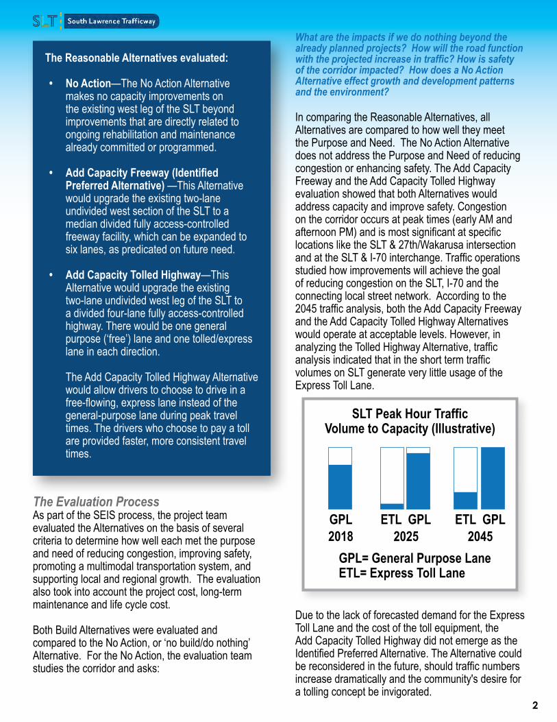
In comparing the Reasonable Alternatives, all Alternatives are compared to how well they meet the Purpose and Need. The No Action Alternative does not address the Purpose and Need of reducing congestion or enhancing safety. The Add Capacity Freeway and the Add Capacity Tolled Highway evaluation showed that both Alternatives would address capacity and improve safety. Congestion on the corridor occurs at peak times (early AM and afternoon PM) and is most significant at specific locations like the SLT & 27th/Wakarusa intersection and at the SLT & I-70 interchange. Traffic operations studied how improvements will achieve the goal of reducing congestion on the SLT, I-70 and the connecting local street network. According to the 2045 traffic analysis, both the Add Capacity Freeway and the Add Capacity Tolled Highway Alternatives would operate at acceptable levels. However, in analyzing the Tolled Highway Alternative, traffic analysis indicated that in the short term traffic volumes on SLT generate very little usage of the Express Toll Lane.
Due to the lack of forecasted demand for the Express Toll Lane and the cost of the toll equipment, the Add Capacity Tolled Highway did not emerge as the Identified Preferred Alternative. The Alternative could be reconsidered in the future, should traffic numbers increase dramatically and the community's desire for a tolling concept be invigorated.
GPL2018
GPL= General Purpose LaneETL= Express Toll Lane
SLT Peak Hour Traffic Volume to Capacity (Illustrative)
ETL ETLGPL GPL2025 2045
The Reasonable Alternatives evaluated: • No Action—The No Action Alternative
makes no capacity improvements on the existing west leg of the SLT beyond improvements that are directly related to ongoing rehabilitation and maintenance already committed or programmed.
• Add Capacity Freeway (Identified Preferred Alternative) —This Alternative would upgrade the existing two-lane undivided west section of the SLT to a median divided fully access-controlled freeway facility, which can be expanded to six lanes, as predicated on future need.
• Add Capacity Tolled Highway—This Alternative would upgrade the existing two-lane undivided west leg of the SLT to a divided four-lane fully access-controlled highway. There would be one general purpose (‘free’) lane and one tolled/express lane in each direction. The Add Capacity Tolled Highway Alternative would allow drivers to choose to drive in a free-flowing, express lane instead of the general-purpose lane during peak travel times. The drivers who choose to pay a toll are provided faster, more consistent travel times.

3
Wakarusa Interchange AlternativeThe at-grade intersection at West 27th Street/Wakarusa Drive would be converted to a grade-separated interchange, with its future location on the SLT corridor to be evaluated. KDOT reviewed three Alternatives to provide access at 27th and Wakarusa and selected the folded diamond as the preferred interchange at this location.
Folded Diamond Alternative:Identified Preferred Alternative at Wakarusa• Connects ramps directly to Wakarusa Drive• Provides more conventional access patterns• Provides the best experience and safety for pedestrians and
bicyclists• Other considerations
• Increased impact to environmentally sensitive areas and right-of-way
• Creates additional intersection along Wakarusa Drive corridor
Split Diamond Hybrid Alternative:• Minimizes right-of-way impacts and impacts to park property,
including 4(f) or environmentally sensitive areas• Provides access close to existing Wakarusa and for traffic
originating or traveling to locations north of K-10• Optimizes number of intersections along Wakarusa Drive• Does not connect the westbound exit ramp directly to
Wakarusa Drive• Combines local and ramp traffic along 27th Street
Connector Diamond Road Alternative:• Uses existing right-of-way for the proposed interchange to the
east along K-10 • Minimizes impacts to park properties, including 4(f) or
environmentally sensitive areas• Offers advantages for traffic flow during construction to
maintain access to Youth Sports Complex• Out of direction travel for traffic to and from locations north of
the SLT
LegendRoadway improvement
Drainage channel realignment
Bridges
LegendRoadway improvement
Drainage channel realignment
Bridges
LegendRoadway improvement
Drainage channel realignment
Bridges
10
10
10

4
What did the evaluation conclude about the other impacts?
Right-of-way impactsImpacts to right-of-way are nearly the same for both Build Alternatives. Both Alternatives use the existing right-of-way along the corridor as much as possible with the same impacts to adjacent properties. Natural environment impactsAnalysis of natural environment impacts includes evaluation of wetlands, floodplains, streams, potential threatened and endangered species, farmland, historical or archaeological resources, parks, trails, noise, and hazardous materials sites. Both Alternatives have similar impacts on the natural environment.
SafetySafety is evaluated by looking at the number of weaving movements (area between where vehicles enter and exit the traffic flow) plus whether there are any at-grade intersections or access to K-10. Both Alternatives are expected to have a significant benefit to safety in the corridor.
Environmental Conditions Map
Rock ChalkPark
ClintonState Park Overlook
Park SoftballComplex
YouthSports
Complex
W 6th St
N 1500 Rd
N 1415 Rd
E 900th Rd
Clinton Pkwy
W 27th St
Wak
arus
a D
r
Iow
a St
N 1800 Rd
Bob Billings Pkwy
Kas
old
Dr
E 80
0 R
d
E 10
00 R
d
W 31st St
LegendProject StudyAreaStreamsExisting BikeLanesExisting BikeRouteExisting SharedUse Path
!!
Utility &CommunicationSites
Schools
î Churches
!?HazardousMaterial SitesCity LimitsPotentialWetlandsCorps ofEngineers LandPrivatePark/Rec AreaPark/Rec AreaFuture ParkPotential HistoricSites
Land Use TypesAgriculturalCommercialDuplex\TriplexIndustrialInstitutionalMultiple FamilyResidentialParks/OpenSpaceSingle FamilyResidential
±0 0.5 10.25Miles

5
As part of the environmental evaluation, KDOT conducted a noise analysis along the entire SLT corridor to determine what the noise impacts were with all the Alternatives evaluated and with the Identified Preferred Alternative. Traffic noise impacts were evaluated in accordance with the FHWA and KDOT traffic noise policies. Those policies define the threshold whereby highway traffic noise impacts occur.
In Kansas, for residences, that threshold is an equivalent steady-state sound level of 66 decibels (dBA) during the loudest traffic noise hour. If a highway traffic noise analysis predicts impacts (utilizing the FHWA Traffic Noise Model, a computer program for acoustics that is validated through field measurements), then measures to abate the noise levels are analyzed. For this project, highway traffic noise impacts are predicted to occur, and abatement measures were evaluated. Safety, engineering decisions, acoustical benefits, and costs (in terms of cost per benefitted residence) are considerations when evaluating abatement measures.
For this project, abatement measures did not meet the policy requirements for these considerations.
Because KDOT takes the position that development should not occur adjacent to its projects, the analysis also provides distances where impacts are predicted to occur, so that noise-compatible human activities can be planned accordingly by the local government.
Noise barriers were analyzed for every location where noise exceeded the threshold of 66 decibels. No noise barriers were determined to be both feasible and reasonable per the full Study report, which can be found on the project website. FHWA and KDOT require that feasible and reasonable noise abatement measures be considered and evaluated for the benefit of all predicted build-condition traffic noise impacts. Feasibility and reasonableness are distinct and separate considerations. Feasibility is the combination of acoustical and engineering factors considered in the evaluation of a noise barrier, such as topography, access, drainage, safety, and maintenance. Reasonableness is the consideration of the economic, cost and environmental factors considered in the evaluation of a noise barrier.
For more information and additional details on the noise study, please visit the project website to review the full noise study report.
Sound Study Summary
110 dBJet Flyover at 1,000 feet
Food Blender at 3 feet
Vacuum Cleaner at 10 feet
Dishwasher Next Room
Quiet Office / Library (Background)
90 dB
70 dB
50 dB
40 dB
Common Sound Level Comparisons
Project loudness threshold as determined by FHWA and KDOT in their noise guidelines and policies.
66 dB

6
What is Section 4(f) and why is it important for SLT?Section 4(f) properties include significant publicly owned public parks, recreation areas, and wildlife or waterfowl refuges, or any publicly or privately owned historic site listed or eligible for listing on the National Register of Historic Places.
Before approving a project that uses Section 4(f) property, FHWA must determine that there is no feasible and prudent Alternative that avoids the Section 4(f) properties and that the project includes all possible planning to minimize harm to the Section 4(f) properties; or, FHWA makes a finding that the project has a de minimis impact on the Section 4(f) property.
What is a Section 4(f) de minimis impact? For publicly owned public parks, recreation areas, and wildlife and waterfowl refuges, a de minimis impact is one that will not adversely affect the activities, features, or attributes of the Section 4(f) property.
It is important that FHWA gathers input from the public before making a final decision. The three conditions include:
• The transportation improvement does not adversely impact the activities or features of the property, either temporarily or permanently.
• The public has the opportunity to review and comment on the effects of the transportation project on the Section 4(f) resources.
• KDOT proposes that the impacts to the properties are minimal and de minimis and the United States Army Corps of Engineers (USACE) and the city must concur. KDOT then makes a request to FHWA, who will determine if the impacts are de minimis.
To mitigate for impacts to USACE property, mitigation and enhancement measures could include replanting the disturbed areas along the SLT roadway as appropriate with trees, shrubs, perennials, and turf, as directed by USACE staff. Areas not specifically targeted for plantings would be returned to existing conditions.
ClintonLake
E 1
200
Rd
E 600 R
d
E 1
000
Rd
W 6th St
N 1750 Rd
N 1500 Rd
Leco
mpt
on R
d
W 6th St
Kas
old
Dr
N 1200 Rd
Wak
arus
a D
r
W 23rd St
Bob Billings Pkwy
E 8
00 R
d
Clinton Pkwy
N 1800 Rd
Iow
a S
t
10
10
10
10
40
40
59
70 70
¯Identified Preferred Alternative
USACE PropertyOverlook ParkRock Chalk Park - City of LawrenceClinton Lake State ParkRock Chalk Park - University of Kansas
Broken Arrow ParkClinton Lake Softball ComplexDeVictor ParkEagle Bend Golf CourseGreen Meadows ParkKanza Southwind Nature Preserve
Mutt RunNaismith Valley ParkPat Dawson Billings Nature AreaPrairie ParkRotary ArboretumSesquicentennial Point
Youth Sports Complex
Clinton Lake Outlet Park
Baker Wetlands
Trails
FIGURE 1: PROJECT AREA PARKS AND TRAILS
0 1 20.5
Miles
South Lawrence TrafficwaySection 4(f) De Minimis Impacts
10-23-KA-3634-01Douglas County
USACE Property – Would impact approximately 13.2 acres of USACE owned property due to realignment of the SLT, addition of two travel lanes and associated grading and contouring, and the addition of a new separated interchange at Wakarusa Drive/27th Street and SLT. The USACE property on the north side of the SLT is not developed and does not contain any amenities.
Rotary Arboretum – Would impact approximately 634 square feet of property at the southeast corner of the Rotary Arboretum property boundary. The impacted property is unused property adjacent to existing KDOT Right-of-way. There would be no impacts to any amenities within the Rotary Arboretum.
Youth Sport Complex – Would impact approximately 5.5 acres of undeveloped Youth Sports Complex property. There would be no impacts to the athletic fields or other amenities of the Youth Sports Complex. Impacts are associated with realignment of the West Branch Yankee Tank Creek, development of the West Branch Yankee Tank Creek Diversion Channel and minor impacts for grading and contouring associated with the new grade separated interchange at Wakarusa/27th
Eagle Bend Golf Course – Would impact approximately 5.8 acres of the Eagle Bend Golf Course property. The impacts would be on undeveloped property on the north side of the Wakarusa River. No features, attributes, or activities of the golf course would be directly or indirectly impacted.
7
Contact:
Visit the project website at www.slt-ks.org (click [email protected] for email). For more information or to leave comments or questions about the SLT Study, please contact Kelly Kultala at (785)-207-0715 or email [email protected] or Brian Kierath at [email protected]
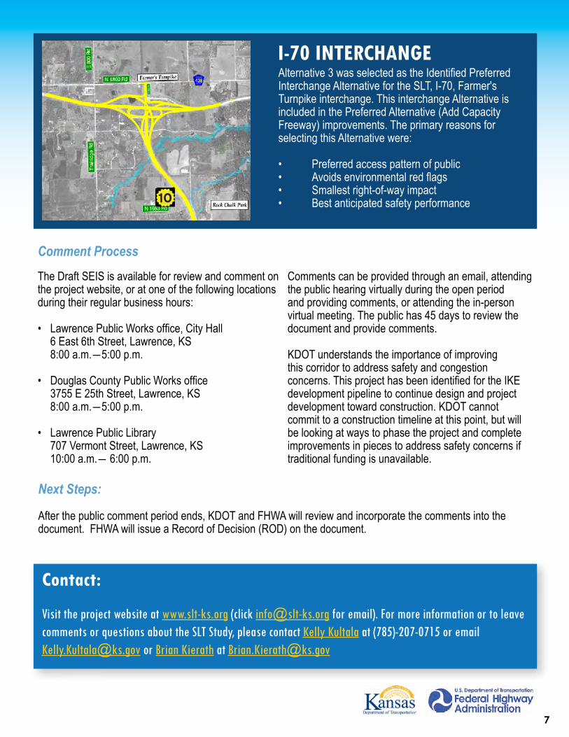
I-70 INTERCHANGEAlternative 3 was selected as the Identified Preferred Interchange Alternative for the SLT, I-70, Farmer's Turnpike interchange. This interchange Alternative is included in the Preferred Alternative (Add Capacity Freeway) improvements. The primary reasons for selecting this Alternative were:
• Preferred access pattern of public• Avoids environmental red flags• Smallest right-of-way impact• Best anticipated safety performance10
The Draft SEIS is available for review and comment on the project website, or at one of the following locations during their regular business hours:
• Lawrence Public Works office, City Hall 6 East 6th Street, Lawrence, KS 8:00 a.m.―5:00 p.m.
• Douglas County Public Works office 3755 E 25th Street, Lawrence, KS 8:00 a.m.―5:00 p.m.
• Lawrence Public Library 707 Vermont Street, Lawrence, KS 10:00 a.m.― 6:00 p.m.
Comments can be provided through an email, attending the public hearing virtually during the open period and providing comments, or attending the in-person virtual meeting. The public has 45 days to review the document and provide comments.
KDOT understands the importance of improving this corridor to address safety and congestion concerns. This project has been identified for the IKE development pipeline to continue design and project development toward construction. KDOT cannot commit to a construction timeline at this point, but will be looking at ways to phase the project and complete improvements in pieces to address safety concerns if traditional funding is unavailable.
Next Steps:
After the public comment period ends, KDOT and FHWA will review and incorporate the comments into the document. FHWA will issue a Record of Decision (ROD) on the document.
Comment Process