SIXTH INTERNATIONAL CONFERENCE ON GEOMORPHOLOGY Cádiz.pdf · SIXTH INTERNATIONALCONFERENCE ON...
80
Transcript of SIXTH INTERNATIONAL CONFERENCE ON GEOMORPHOLOGY Cádiz.pdf · SIXTH INTERNATIONALCONFERENCE ON...


SIXTH INTERNATIONAL CONFERENCE ON GEOMORPHOLOGY
GEOMORPHOLOGY OF THE SOUTH-ATLANTIC SPANISH COAST
F. J. Gracia-Prieto (Coord.)
FIELD TRIP GUIDE - A4

SIXTH INTERNATIONALCONFERENCE ON GEOMORPHOLOGY
GEOMORPHOLOGY OF THE SOUTH-ATLANTIC SPANISH COAST Coordination: F.J. Gracia-Prieto Departamento de Geología, Facultad de Ciencias del Mar y Ambientales, Universidad de Cádiz, 11510 – Puerto Real (Cádiz), Spain (e-mail: [email protected])
Leaders: F. Borjaa (chapter II), A. Rodríguez-Ramírezb (chapter III) and F.J. Gracia (chapters I, IV and V). a: Área de Geografía Física, Facultad de Ciencias Experimentales, Universidad de Huelva, 21071 Huelva, Spain (e–mail: [email protected]) b: Departamento de Geodinámica y Paleontología. Univ. de Huelva. Avda. Fuerzas Armadas, s/n. 21071-Huelva, Spain.(e-mail: [email protected]) Other authors: C. Alonsoa, G. Anfusob, J. Benaventeb, C. Borjac , L. Cáceresd, C.J. Dabrioe , L. Del Ríob, F. Díaz del Olmoc, L. Domínguezb, J.L. Goyf, J. Lariog , J.A. Martínezb, N. Mercierh, J. Rodríguez-Vidald, E. Roqueroi, J.C. Rubioj, P.G. Silvaf and C. Zazok. a: Instituto Andaluz del Patrimonio Histórico, Consejería de Cultura de la Junta de Andalucía. Centro de Arqueología Subacuática, Balneario de la Palma, Cádiz. E-mail: [email protected] b: Departamento de Geología, Facultad de Ciencias del Mar y Ambientales, Universidad de Cádiz, 11510 – Puerto Real (Cádiz), Spain (e-mails:[email protected] ; [email protected] ; [email protected] ; [email protected] ; [email protected]) c: Departamento de Geografía Física y Análisis Geográfico Regional. Universidad de Sevilla. C/ María de Padilla, s/n. 41004-Sevilla. Spain. (e-mails: [email protected].; [email protected] ) d: Departamento de Geodinámica y Paleontología. Univ. de Huelva. Avda. Fuerzas Armadas, s/n. 21071-Huelva, Spain.(e-mails: [email protected] ; [email protected]) e Departamento de Estratigrafía–UCM and Instituto de Geología Económica–CSIC, Universidad Complutense, 28040–Madrid, Spain (e–mail: [email protected]) f: Departamento de Geología, Facultad de Ciencias, Universidad, 37008–Salamanca, Spain (e–mail: [email protected] ; [email protected]) g: Departamento de Ingeniería Geológica y Minera, Facultad de Ciencias del Medio Ambiente, Universidad de Castilla La Mancha, Toledo, Spain (e–mail: [email protected]) h: Laboratoire des Sciences du Climat et de l’Environnement, CEA–CNRS, Av. de la Terrasse, 91198– Gif-Sur-Yvette Cedex, France (e–mail: [email protected]–gif.fr) i: Departamento de Edafología, ETS I. Agrónomos, Universidad Politécnica, 28040–Madrid, Spain (e–mail: [email protected]) j Director of “Marismas del Odiel” protected area. Regional Ministry for Environment. Andalusian Regional Government. k: Departamento de Geología, Museo Nacional de Ciencias Naturales–CSIC, 28006–Madrid, Spain (e–mail:(CZ) [email protected])
Chapter 1: Introduction to theGulf of Cadiz Coast J. Benavente, F. Borja, F.J. Gracia and A. Rodríguez
I.1. Geological framework The Gulf of Cadiz occupies the SW margin of the Iberian Peninsula. The Spanish part of the Gulf extends from the Guadiana River mouth, in the border with Portugal (37º40’N, 9ºW), to the Strait of Gibraltar (36º00’N, 6ºW). Climate in the region can be considered as of Mediterranean type. However, the Atlantic influence determines an increased humidity, as well as more temperate conditions regarding maximum and minimum temperatures through the year. Rainfall averages around 550 mm/yr (Ballesta et al., 1998), mainly concentrated in winter months. Geologically, this coastal zone is included into two main units of regional extent: the Betic Cordillera and the Tertiary Guadalquivir Basin (Fig. 1). The Betic Cordillera is the westernmost segment of the European part of the Alpine orogenic belt. It is a collisional orogen generated by
Geomorphology of the South-Atlantic Spanish Coast
2
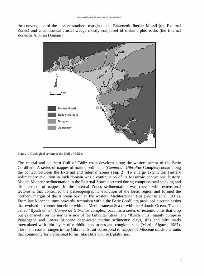
the convergence of the passive southern margin of the Palaeozoic Iberian Massif (the External Zones) and a continental crustal wedge mostly composed of metamorphic rocks (the Internal Zones or Alboran Domain).
Figure 1. Geological setting of the Gulf of Cádiz. The central and southern Gulf of Cádiz coast develops along the western sector of the Betic Cordillera. A series of nappes of marine sediments (Campo de Gibraltar Complex) occur along the contact between the External and Internal Zones (Fig. 2). To a large extent, the Tertiary sedimentary evolution in each domain was a continuation of its Mesozoic depositional history. Middle Miocene sedimentation in the External Zones occurred during compressional stacking and displacement of nappes. In the Internal Zones sedimentation was coeval with extensional tectonism, that controlled the palaeogeographic evolution of the Betic region and formed the northern margin of the Alboran basin in the western Mediterranean Sea (Alonso et al., 2002). From late Miocene times onwards, tectonism within the Betic Cordillera produced discrete basins that evolved in connection either with the Mediterranean Sea or with the Atlantic Ocean. The so-called “flysch units” (Campo de Gibraltar complex) occur as a series of tectonic units that crop out extensively on the northern side of the Gibraltar Strait. The “flysch units” mainly comprise Palaeogene and Lower Miocene deep-water marine sediments: clays, silts and silty marls intercalated with thin layers of turbidite sandstones and conglomerates (Martín-Algarra, 1987). The main coastal ranges in the Gibraltar Strait correspond to nappes of Miocene sandstone units that commonly form erosional forms, like cliffs and rock platforms.

F.J. Gracia –Prieto (Coord.)
3
Figure 2. Geological sketch map of the Betic Cordillera (Azañón et al., 2002). a, Iberian Massif; b, Subbetic zone; c, Prerif and Mesorif; d, Prebetic zone; e, olitostromes and breccias; f, Campo de Gibraltar flysch; g, Nevado-Filábride complex; h, Alpujárride complex (p, peridotites); i, Maláguide; j, Ronda flysch; k, Neogene basins; dots, volcanic rocks. The Neogene tectonic evolution of the Western Betic Cordillera consisted in a shifting from and initial distensive regime (Tortonian - Pliocene) to a compressive one during the Quaternary. Tectonic stress during recent times is distributed through a wide range of interactive transpressive and extensional processes (Ribeiro et al., 1996). This structural evolution took place in concert with important regional uplift that promoted the development of small marine basins on both sides of the Gibraltar Arc, the Alboran Basin to the East (Mediterranean) and the Gulf of Cádiz to the West (Atlantic). The external part of the Gibraltar Arc consists mainly of allochtonous Upper Triassic salts and Middle Miocene shales that are together known as the “Olistostrome Unit”. The emplacement of this unit is related to the westward migration of the Gibraltar Arc front and includes sediment bodies that migrated downslope toward the Atlantic by gravitational collapse. This submarine mass-wasting was eased by the inherent weakness of the salts involved (Maestro et al., 2003).
The Guadalquivir Basin, one of the main tertiary depressions in the Iberian Peninsula, is the foreland basin of the Subbetic nappes and is bordered to the North by the Iberian Meseta. The basin opens directly to the Atlantic Ocean in the WSW, Gulf of Cádiz area. In a broad sense, the lower Guadalquivir Depression is basically made up by a series of Neogene units of marine origin overlaid by Quaternary (both marine and continental) formations. Its upper Miocene-Pliocene

Geomorphology of the South-Atlantic Spanish Coast
4
sedimentary infill includes several sequences from early Tortonian to early Pliocene in age. All of them, normally around 300-400 m thick, have bioclastic sandstones deposited on a shelf at the eastern margin of the basin and prograded to the WSW over previous silty clays and marls deposited on the shelf slope (Fig. 3). Alluvial and fluvial red sandstones of uncertain age (late Pliocene – Pleistocene) overlie the marine deposits in Huelva (Zazo, 1979). South of Cádiz, marine sedimentation went on up to the final Pliocene with several units that represent different sedimentary environments, from outer shelf sandstones to beach sandstones and siltstones (Aguirre, 1995). The last unit in the Bay of Cádiz is a shallowing-upward sequence of wave- and tidal-dominated delta deposits prograding SSW.
Figure 3. Palaeogeographic evolution of Southern Spain from the late Tortonian to early Pliocene interval (after Alonso et al., 2002). a, Late Tortonian; b, Early Messinian; c, Early Pliocene. The regressive sea level trend during the late Pliocene made previous deposits to become exposed to continental subaerial processes and hence all these sedimentary units contain numerous traces and modifications linked to subaerial weathering and edaphogenesis. The lack of a continuous palaeontological record in the stratrigraphic sequence makes these traces as the main indicator of

F.J. Gracia –Prieto (Coord.)
5
the beginning of the continentalization of the zone, a progressive process that took place between the Upper Pliocene (Rodríguez Vidal, 1989) and the Lower Pleistocene (Torcal et al., 1990). During this period of marine withdrawal, an incipient fluvial network strongly conditioned by sea level fluctuations became an organised network with well-defined valleys and a wide development of fluvial terraces (Cáceres, 1999). Along the Spanish littoral zone of the Gibraltar Strait several sets of staircased Quaternary marine deposits can be observed ranging from 80 to 2.5-1.5 m a.p.s.l. (Zazo et al., 1999b). Remains of Pleistocene sea level highstands for the Atlantic coast of the Gibraltar Strait were previously studied by Zazo and Goy (1990a,b), among others. Finally, throughout the Holocence a series of littoral formations developed underlying previous Neogene and Quaternary units. Present seismotectonic activity in the Gulf of Cádiz is associated to the lithospheric plate boundary between Eurasia and Africa (Fig. 4). Earthquakes are of small to moderate magnitude (M ≤ 5) with only a few occurrences of larger events separated by long time intervals (Buforn and Udías, 1991). Historically, the most dramatic earthquake took place in 1755, known as the “Lisbon Earthquake”, although its epicentre was located in the Gulf of Cádiz, south of Cape San Vicente. Most of the seismic activity is located in an area limited to the North by the stable Spanish plateau (Iberian Meseta) and to the South by the hypothetical location of the plate boundary in north Morocco and its westward prolongation in the Gulf of Cádiz. This region is subjected to a general stress regime of horizontal compression in a NW-SE direction (Fig. 4), well documented by earthquake focal mechanisms (Moreira, 1991).
Figure 4. Seismotectonic framework on South Spain (Buforn and Udías, 1991). Small arrows indicate directions of the horizontal stress derived from earthquake focal mechanisms. Circles represent shallow foci, triangles intermediate and deep shocks. Thick arrows show directions of pressure axes for two large earthquakes (28-2-1969 and 10-10-1980). Large arrows show the inferred directions of regional stresses.

Geomorphology of the South-Atlantic Spanish Coast
6
I.2. Geomorphological features of the Gulf of Cádiz coast
Tectonics is a prime control on the present littoral morphology in the area as it imposes the orientation and shape of the coastline and the related fluvial courses. This is the case of the E-W trending faults that delineate the coast between Ayamonte and Huelva, and the roughly N-S oriented faults that delineate the Odiel, Tinto and Guadalquivir estuaries, the coast in Rota and Sanlúcar, etc. The rise of sea level associated to the Last Deglaciation flooded the tectonically-controlled coast and set in motion the present morphosedimentary systems.
The Spanish coast of the Gulf of Cádiz can be divided in two main sectors. The northwestern part (Huelva coast) is an E-W to WNW-ESE sandy coast fed by several important rivers that drain the Neogene Guadalquivir Basin; coastal environments consist of sandy beaches in front of sandy cliffs or protecting wide salt marshes. The southeastern part (Cadiz coast) is represented by a NW-SE mixed sandy-rocky coast with several sandy embayments fed by short rivers draining the western Betic Ranges. Coastal sediment sources are mainly represented by fluvial supplies and by the erosion of the weakly-cemented Cainozoic sandstones exposed in the cliffs from Cape San Vicente (Portugal) to Cádiz. Rainfall increases sediment runoff from river basins during winters. However, sediment supply from rivers draining into the Gulf has dramatically decreased in the last century as a result of dam construction on river basins. The morphosedimentary model best represented in the area is the spit-barrier-dune - lagoon complex, which occurs associated to the mouths of the major rivers, and evolved under gentle Holocene sea-level fluctuations. From a geographical point of view, they are beach-dune-wetland models, all of them classified as protected natural areas (Fig. 5). Complexes with barrier islands and/or spit barriers, aeolian sediments (foredunes, dune fields or littoral aeolian sheets) and wetlands (alluvial and tidal marshes) occur in Isla Canela-Ayamonte (Guadiana River), El Rompido (Piedras River), Punta Umbría (Tinto and Odiel rivers), Doñana (Guadalquivir River) and Valdelagrana (Guadalete River). Some of these include fresh-water coastal lagoons (lagunas). The largest ones are El Portil, related to El Rompido spit, and Las Madres (that also acted temporary as a peat bog), related to Punta Umbría spit. Concerning sea level trends and their influence on the Late Quaternary evolution of the cited morpho-sedimentary units, there is a general tendency for the Atlantic-Mediterranean linkage area. The sea level reached 120 m below present sea level (b.p.s.l.) at ca. 18 000 yr BP and then rose gently to 100 m b.p.s.l. between 16 000 and 14 000 yr BP, as measured off the Portuguese coast. The rise accelerated between 13 000 and 11 000 yr BP and sea level reached 40 m b.p.s.l. to recede again to 60 m b.p.s.l. between 11 000 and 10 000 yr BP (Younger Dryas). A new acceleration took place between 10 000 and 8000 yr BP, and sea level rose to 20 m b.p.s.l. Then, a new deceleration of the rising trend has been recorded (Somoza, et al., 1998). These depths are similar to those deduced from drill cores in Guadalete and Odiel estuaries: The first evidence of marine sedimentation in these estuaries was found in drill cores around 25-30 m b.p.s.l. and dated as 10 000 calBP (Dabrio et al., 2000). This is roughly the time when a palaeo-delta began to form in the Guadalquivir embayment (Lario, 1996). A new acceleration of the rising trend marks the last stages before the transgressive maximum ca. 6500 14C yr BP when the sea level slightly surpassed its present position.

F.J. Gracia –Prieto (Coord.)
7
Figure 5. Geomorphological sketch of the central Gulf of Cádiz coast (Zazo et al., 2005). SV: Cape San Vicente, G: Gibraltar Rock, ML–97: Mari López borehole (Zazo et al., 1999c).

Geomorphology of the South-Atlantic Spanish Coast
8
Morpho-sedimentary features and radiocarbon dating of spit bars in the Atlantic-Mediterranean linkage area allow to separate two main prograding phases (6500 – 2700 calBP and 2400 calBP - present), separated by a large gap representing a major episode of restricted sedimentation or erosion between 2700 and 2400 calBP (Borja et al., 1999, Dabrio et al., 1999, 2000). In detail, two morpho-sedimentary prograding subunits (H units) are distinguished inside each prograding phase, with intervening swales or erosional surfaces (gaps). The ages of H units are: H1 (6500-4700 calBP), H2 (4400-2700 calBP), H3 (2400-700 calBP), and H4 (500 calBP- present). At present unit H1 has only been recognised in Almería coast (western Betic coast, fig. 2). Sea level had a direct influence in the filling of estuaries and their transformation into marshlands (Fig. 5). Sedimentation was mainly aggradational in the estuaries between ~6500 and 2700 calBP, but changed to mainly progradational in spit barriers and related aeolian dunes after ~2700 calBP. Nowadays all the estuaries in the area have been transformed into more or less developed marshlands. The regional trend to aridity in the last 5.5 kyr and the high sea levels increased the sediment input to the coastal zone allowing the accumulation of aeolian dunes under reinforced westerly to south-westerly winds. Three post-flandrian aeolian systems (D1 to D3) have been identified associated to the spit systems (Borja et al., 1999). I.3. Present coastal dynamics in the Gulf of Cádiz Active processes on the Gulf of Cádiz coast are mainly controlled by atmospheric and oceanographic agents like winds, waves and tides. Dominant winds in Huelva coast blow from the 3rd and 4th quadrants. Winds from the SW are usually related to winter storms and show 22.5% of annual occurrence, while NW winds have a frequency of 18.5%, both of them showing the highest wind speeds (Fig. 6). Winds blowing from SE and NE are also important, specially during the summer season, with annual frequencies of 14% and 12%, respectively (Ballesta et al., 1998).
Figure 6. Wind frequency and speed in the Huelva coast (Ballesta et al., 1998). In the Cádiz coast winds blow from the 2nd and 4th quadrants (Fig. 7). In the former, SE winds (Levante) must be highlighted as they show 19.6% of annual occurrence and a mean speed of 27.8 Km/h. Levante winds play an important role in aeolian transport due to their high velocities,
WIND
SPEED
CALMW

F.J. Gracia –Prieto (Coord.)
9
especially near the Gibraltar Strait, where gusts around 100 Km/h are quite common. Nevertheless, the role played by Levante winds as wave-generator is usually negligible because of their short fetch in the Gulf of Cádiz. In the 4th quadrant the most important winds blow from WNW (Poniente), with an annual frequency of 12.8% and a mean speed of 15.8 Km/h. Besides, SW, WSW and W winds are also relevant. The main significance of Poniente winds in the Gulf of Cadiz is related to their role as wave generators due to the long fetch. In fact, Poniente winds caused by Atlantic fronts generate the most energetic waves in the area.
[Figure 7]
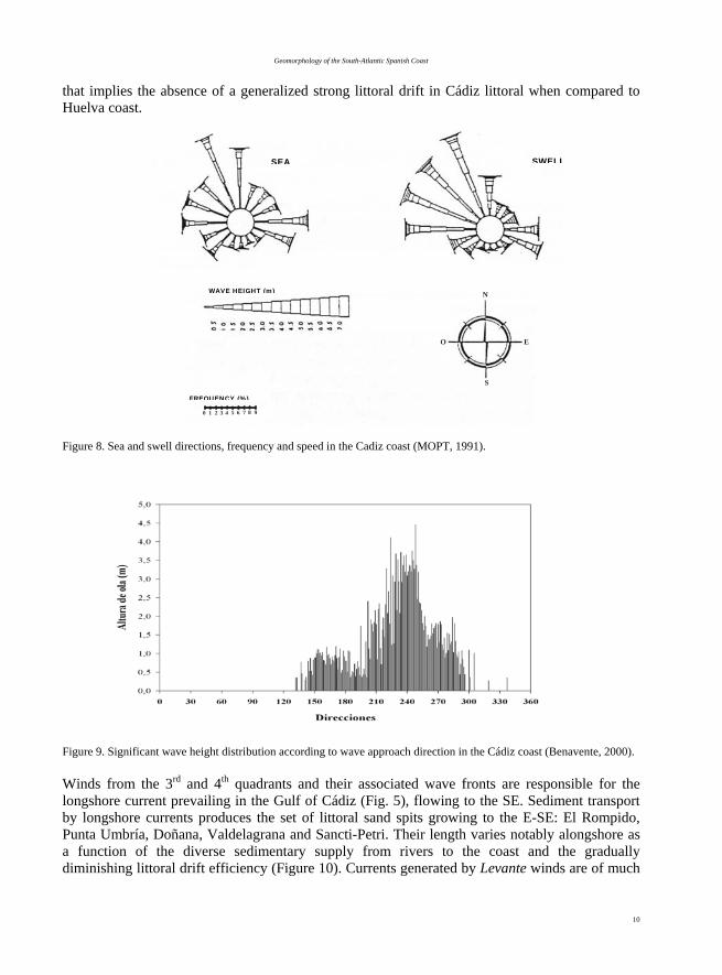
Figure 7. Wind frequency and speed in the Cádiz coast (Muñoz-Pérez and Sánchez, 1994). Waves in the Gulf of Cádiz are directly linked to wind regime and coastal orientation. The changing coastline orientation influences the final wave approaching angle, which progressively diminishes towards the South. Prevailing waves in Huelva coast approach from the SW (annual frequency of 20%) and from the SE (frequency of 10%). As for wave height, 75% of waves are lower than 0.5 m, while only 7% of waves exceed 1 m, usually as swell waves generated by offshore storms (Ballesta et al., 1998). Such a wave regime classifies the Huelva littoral as a low-energy coast. The combination of wave approach directions and coastal orientation (WNW-ESE) produces a strong littoral drift along Huelva coast, which transports sediments Eastwards at a rate that has been mathematically modelled to amount around 260 000 m3/yr (Medina, 1991). In the coast of Cádiz both sea and swell waves approach mainly from the NW, while sea waves approach also from E and SSE directions (Fig. 8). Coastline orientation determines swell waves to be bidirectional along the WNW (6%) – WSW (6%) sectors (Benavente, 2000). Wave fronts near the coast are predominantly Westerly waves (Fig. 9). As a result, most frequent and most powerful storms approach the coast from WNW, a direction nearly perpendicular to the coastline
FREQUENCY
SPEED
Geomorphology of the South-Atlantic Spanish Coast
10
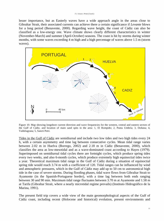
that implies the absence of a generalized strong littoral drift in Cádiz littoral when compared to Huelva coast. Figure 8. Sea and swell directions, frequency and speed in the Cadiz coast (MOPT, 1991).
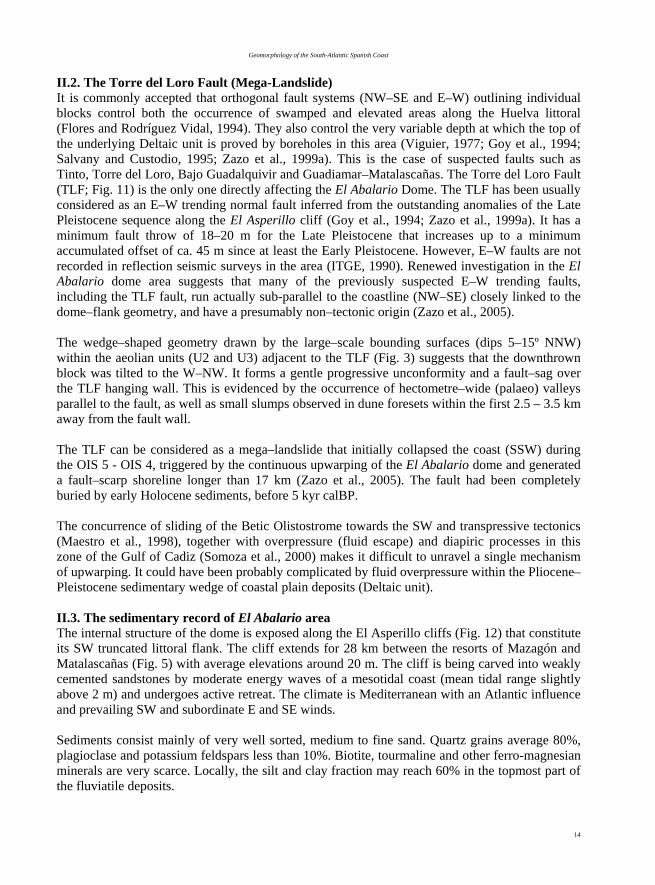
Figure 9. Significant wave height distribution according to wave approach direction in the Cádiz coast (Benavente, 2000). Winds from the 3rd and 4th quadrants and their associated wave fronts are responsible for the longshore current prevailing in the Gulf of Cádiz (Fig. 5), flowing to the SE. Sediment transport by longshore currents produces the set of littoral sand spits growing to the E-SE: El Rompido, Punta Umbría, Doñana, Valdelagrana and Sancti-Petri. Their length varies notably alongshore as a function of the diverse sedimentary supply from rivers to the coast and the gradually diminishing littoral drift efficiency (Figure 10). Currents generated by Levante winds are of much
N
E
S
O
FRECUENCIA (%)
0 1 2 3 4 5 6 7 8 9
ESCALA DE ALTURAS H (m)v
SEA SWELL
FREQUENCY (%)
WAVE HEIGHT (m)
F.J. Gracia –Prieto (Coord.)
11
lesser importance, but as Easterly waves have a wide approach angle in the areas close to Gibraltar Strait, their associated currents can achieve there a certain significance if Levante blows for a long period (Benavente, 2000). Regarding wave height, the coast of Cádiz can also be classified as a low-energy one. Wave climate shows clearly different characteristics in winter (November-March) and summer (April-October) seasons. The coast is hit by storms during winter months, with some waves exceeding 4 m high and a high percentage of waves above 1.5 m (storm waves).
Figure 10. Map showing longshore current direction and wave frequencies for the western, central and eastern sectors of the Gulf of Cádiz, and location of main sand spits in the area: 1, El Rompido; 2, Punta Umbría; 3, Doñana; 4, Valdelagrana; 5, Sancti Petri. Tides in the Gulf of Cádiz are semidiurnal and include two low tides and two high tides every 24 h, with a certain asymmetry and time lag between consecutive cycles. Mean tidal range varies between 2.02 m in Huelva (Borrego, 2002) and 2.18 m in Cádiz (Benavente, 2000), which classifies the area as low-mesotidal and as a wave-dominated coast according to Hayes (1979). Superimposed on semidiurnal tidal cycles there are fortnight cycles, which produce spring tides every two weeks, and also 6-month cycles, which produce extremely high equinoctial tides twice a year. Theoretical maximum tidal range in the Gulf of Cádiz during a situation of equinoctial spring tide would reach 3.74 m with a coefficient of 120. Tidal ranges can be influenced by wind and atmospheric pressures, which in the Gulf of Cádiz may add up to 50 cm to astronomical high tide in the case of severe storms. During flooding phases, tidal wave flows from Gibraltar Strait to Ayamonte (in the Spanish-Portuguese border), with a time lag between both ends ranging between 30 and 90 min. Maximum tidal range fluctuates between 3.70 m at Ayamonte and 1.58 m at Tarifa (Gibraltar Strait, where a nearly microtidal regime prevails) (Instituto Hidrográfico de la Marina, 1991). The present field trip covers a wide view of the main geomorphological aspects of the Gulf of Cádiz coast, including recent (Holocene and historical) evolution, present environments and
0 40 kmN
4
3
5
21PORTUGAL
HUELVA
CADIZ
Strait of G
ibraltar

Geomorphology of the South-Atlantic Spanish Coast
12
active coastal dynamics. The following exposition is divided into four parts that include all these aspects of the Gulf of Cádiz following a W-E travel direction: Holocene evolution of the Huelva coast (chapter II), recent evolution and present coastal environments of the Doñana National Park (chapter III), historical evolution and coastal erosion problems in the Cádiz coast (chapter IV) and structural geomorphology and coastal neotectonics of the Gibraltar Strait (chapter V). Chapter II: Holocene evolution of the Huelva Coast F. Borja, C. Dabrio, E. Roquero, C. Zazo, C. Borja, J. Lario, F. Díaz del Olmo and J.C. Rubio. II.1. Introduction to the geomorphology of El Abalario area El Abalario area includes the most recent part of the sedimentary fill of the western Guadalquivir basin (Fig. 5). It records the interaction of sedimentation on a coastal plain (including sea level changes of varying magnitudes) and upwarping, and helps to understand the evolving linkage of catchments and coast during the Late Quaternary in an emergent sandy coast. This is very useful in order to evaluate the driving mechanisms that acted on coastal evolution, one of the main topics of the IGCP 495 Project: “Quaternary Land-Ocean Interactions”. El Abalario Dome is an elliptical–shaped topographic feature, elongated in a NW–SE direction (Fig. 11). This elevated area served as anchor to the Holocene spit–bars and dune systems forming the Doñana littoral bar (Fig. 5) that eventually closed the Guadalquivir river basin (Zazo et al., 1994; Rodríguez Ramírez et al., 1996, Zazo et al., 2005). The northeast limit of the dome is the La Rocina River, whereas El Asperillo cliffs constitute the SW truncated littoral flank of the dome. The dimensions of the dome are ca. 48–51 km for the NW–SE major axis and 12.5–16 km for the NE–SW minor axis. The mean altitude of the dome along the present watershed is 70–75 m a.s.l., but its real ridge–line is located near the sea–cliff where active dunes reach a maximum altitude of 106 m (El Asperillo geodetic bench–mark). The drainage pattern within the dome is pseudo–radial and divergent, forced by the elliptical shape of the topography. However, watercourses do not reach the top of the dome, and the zone between the watershed and the dome ridge–line lacks a defined drainage and contains several shallow ponds distributed at random (Fig. 11). The drainage pattern is asymmetric, with the longer streams in the inland (NE) flank flowing to La Rocina river valley and short gullies that dissect the present sea–cliff at the coast (SW). The gully system at the SE perimeter of the dome, near Matalascañas, is presently buried under recent aeolian dunes described by Borja and Díaz del Olmo (1994, 1996). The drainage pattern along the inland flank (NE) is sub–parallel and very similar to the dissection patterns observed in periclinal terminations and diapirs. Remarkable features in this area are the occurrence of unusual ephemeral ponded zones at the headwaters of the streams, and channel diversions and deflections along the uppermost segments of the streams following a NW-SE trend (Fig. 11). The concurrence of anomalous drainage and geological lineaments strongly suggests that the main mechanism controlling the surface hydrology in the El Abalario Dome is faulting (or gravitational sliding) linked to active upwarping.

F.J. Gracia –Prieto (Coord.)
13
Fi
gure
11:
Geo
logi
cal a
nd G
eom
orph
olog
ical
syn
thet
ic m
ap o
f the
El A
bala
rio
Dom
e (Z
azo
et a
l., 2
005)
. Leg
end:
1, S
ubae
rial d
rain
age
netw
ork;
2, o
ffsh
ore
drai
nage
line
s; 3
, Dra
inag
e di
vide
with
hei
ght s
pots
; 4, T
orre
del
Lor
o Fa
ult (
TLF)
line
s; 5
, Zon
e of
dra
inag
e an
omal
y at
the
dom
e to
p; 6
, sha
llow
pon
ds a
nd
pond
ed a
reas
; 7, L
igni
te e
xplo
ratio
n w
ells
; 8, H
ydro
geol
ogic
al e
xplo
ratio
n w
ells
(Sal
vany
and
Cus
todi
o, 1
995)
; 9, P
etro
leum
exp
lora
tion
wel
ls (I
TGE,
199
0);
10, G
eode
tic b
ench
–mar
ks:
106
m b
ench
-mar
k co
rres
pond
s to
El
Asp
erill
o; 1
1, P
lioce
ne–P
leis
toce
ne s
andy
coa
stal
–pla
in d
epos
its;
12, L
ate
Plei
stoc
ene
upth
row
n bl
ock
depo
sits
; 13,
Lat
e Pl
eist
ocen
e do
wnt
hrow
n bl
ock
depo
sits
and
Hol
ocen
e du
ne s
yste
ms;
14,
Coa
stal
act
ive
dune
sys
tem
s on
sea
–clif
f; 15
, Pr
esen
t bea
ch d
epos
its; 1
6, M
arsh
land
s (in
bla
ck: c
hann
el sy
stem
s); 1
7, L
ocal
ities
.
Geomorphology of the South-Atlantic Spanish Coast
14
II.2. The Torre del Loro Fault (Mega-Landslide) It is commonly accepted that orthogonal fault systems (NW–SE and E–W) outlining individual blocks control both the occurrence of swamped and elevated areas along the Huelva littoral (Flores and Rodríguez Vidal, 1994). They also control the very variable depth at which the top of the underlying Deltaic unit is proved by boreholes in this area (Viguier, 1977; Goy et al., 1994; Salvany and Custodio, 1995; Zazo et al., 1999a). This is the case of suspected faults such as Tinto, Torre del Loro, Bajo Guadalquivir and Guadiamar–Matalascañas. The Torre del Loro Fault (TLF; Fig. 11) is the only one directly affecting the El Abalario Dome. The TLF has been usually considered as an E–W trending normal fault inferred from the outstanding anomalies of the Late Pleistocene sequence along the El Asperillo cliff (Goy et al., 1994; Zazo et al., 1999a). It has a minimum fault throw of 18–20 m for the Late Pleistocene that increases up to a minimum accumulated offset of ca. 45 m since at least the Early Pleistocene. However, E–W faults are not recorded in reflection seismic surveys in the area (ITGE, 1990). Renewed investigation in the El Abalario dome area suggests that many of the previously suspected E–W trending faults, including the TLF fault, run actually sub-parallel to the coastline (NW–SE) closely linked to the dome–flank geometry, and have a presumably non–tectonic origin (Zazo et al., 2005). The wedge–shaped geometry drawn by the large–scale bounding surfaces (dips 5–15º NNW) within the aeolian units (U2 and U3) adjacent to the TLF (Fig. 3) suggests that the downthrown block was tilted to the W–NW. It forms a gentle progressive unconformity and a fault–sag over the TLF hanging wall. This is evidenced by the occurrence of hectometre–wide (palaeo) valleys parallel to the fault, as well as small slumps observed in dune foresets within the first 2.5 – 3.5 km away from the fault wall. The TLF can be considered as a mega–landslide that initially collapsed the coast (SSW) during the OIS 5 - OIS 4, triggered by the continuous upwarping of the El Abalario dome and generated a fault–scarp shoreline longer than 17 km (Zazo et al., 2005). The fault had been completely buried by early Holocene sediments, before 5 kyr calBP. The concurrence of sliding of the Betic Olistostrome towards the SW and transpressive tectonics (Maestro et al., 1998), together with overpressure (fluid escape) and diapiric processes in this zone of the Gulf of Cadiz (Somoza et al., 2000) makes it difficult to unravel a single mechanism of upwarping. It could have been probably complicated by fluid overpressure within the Pliocene–Pleistocene sedimentary wedge of coastal plain deposits (Deltaic unit). II.3. The sedimentary record of El Abalario area The internal structure of the dome is exposed along the El Asperillo cliffs (Fig. 12) that constitute its SW truncated littoral flank. The cliff extends for 28 km between the resorts of Mazagón and Matalascañas (Fig. 5) with average elevations around 20 m. The cliff is being carved into weakly cemented sandstones by moderate energy waves of a mesotidal coast (mean tidal range slightly above 2 m) and undergoes active retreat. The climate is Mediterranean with an Atlantic influence and prevailing SW and subordinate E and SE winds. Sediments consist mainly of very well sorted, medium to fine sand. Quartz grains average 80%, plagioclase and potassium feldspars less than 10%. Biotite, tourmaline and other ferro-magnesian minerals are very scarce. Locally, the silt and clay fraction may reach 60% in the topmost part of the fluviatile deposits.

F.J. Gracia –Prieto (Coord.)
15
Figu
re 1
2: S
chem
atic
pro
file
show
ing
the
dist
ribut
ion
of s
edim
enta
ry u
nits
and
pal
aeos
ols.
Not
e th
e st
rong
ver
tical
exa
gger
atio
n. D
ista
nces
in k
m fr
om
Torr
e de
la H
igue
ra w
atch
tow
er (m
odifi
ed fr
om Z
azo
et a
l., 1
999a
).

Geomorphology of the South-Atlantic Spanish Coast
16
Zazo et al. (1999a, 2005) used sedimentary facies analysis, palaeocurrent measurements, subsurface data from hydrological drillings, Optically Stimulated Luminiscence (OSL) and radiocarbon measurements (AMS and conventional) to distinguish several units and to prove that the TLF separated two palaeogeographic domains (Fig. 12). The upthrown tectonic block contains fluvial, marine and aeolian deposits (in ascending stratigraphic order), whereas the downthrown block trapped aeolian sediments and laterally discontinuous sand layers rich in organic matter, in which three units (U1 to U3) were identified. A surface enriched in iron oxide fossilised the fault trace sealing both blocks (Fig. 12). It is covered by younger semi–mobile and mobile aeolian dunes (U4, U5 and U6) that accumulated growing to topographic elevations above 100 m. A summary of the main stratigraphic and sedimentological data of Plio-Quaternary deposits in the Asperillo cliff is given in Zazo et al. (2005, Fig. 13). Paleogeographical and geomorphological evolution of the El Abalario dome during the Late Pleistocene-Holocene is given in Fig. 14 (Zazo et al., 2005). II.4. The littoral aeolian sheet-wetland complex of El Abalario-Doñana The littoral aeolian sheet of El Abalario-Doñana supports 633 ponds (the highest density in Spain) of which only a half have a well-known name (Coleto, 2003). Most of them are seasonal and small, averaging less than 5 hectares in size. During periods of high waters, the regional aquifer contributes to the ponds and many of them form groups with mutual interconnections. In any other times, only the ponds placed along the Línea de la Mediana or Ribatehilos (zone of drainage anomalies at the dome top) remain connected to the aquifer. The rest of them only receive water from sub-superficial flows along the semi-permeable hydromorphic layers (Borja, 1992). The dominant pond morphology is rounded, with a very low index of irregularity, because they are typically related to blowouts. Elongate ponds are related to inter-dune corridors and dune fronts. Ponds in El Abalario-Doñana wetland complex occur associated to the so-called Alto Manto Eólico Húmedo (AMEH= high wet aeolian sheet, Fig. 15, see also Stop 3) that was accumulated by Late Pleistocene-Holocene times, ca. 11 kyr BP (Borja, 1997). Both the AMEH and the pond landscape are covered (fossilised) by the Alto Manto Eólico Seco (AMES= high dry aeolian sheet) of middle Holocene age (approx. 5 - 4 kyr BP). Stop 1: Matalascañas C.J. Dabrio, E. Roquero, C. Zazo, F. Borja, J.L. Goy, N. Mercier, P.G. Silva and J. Lario The aim of these stop is to analyse the most important stratigraphical elements in the upthrown block of Torre del Loro Fault near Matalascañas: basal palaeosol, ancient and recent aeolian units, and iron oxide crust discontinuity. S1.1. Palaeosol (Ps 2) The oldest unit exposed at the base of the cliff near Torre de la Higuera (Matalascañas) is a palaeosol (Ps 2 in Fig. 12). Is consists of clayey sands, somewhat plastic and adherent, with vertically-elongated segregations, 10 to 20 cm in diameter that suggest a genetic relation with roots. Segregations have a concentric structure with a pale–yellow (2.5 Y /4 m) nucleus that changes at the periphery to intense brown (7.5 YR 5/8 m) and, finally, to the preserved remains of the original red (2.5 YR 4/6 m) matrix of the soil. Mineralogy of the brown and reddish zones is

F.J. Gracia –Prieto (Coord.)
17
very similar: quartz (70–71%), microcline (3%), ilmenite (1%), hematite (1%), goethite (1%), micas (6%) and kaolinite (18–19%).
Figure 13: Summary of stratigraphic and sedimentological data of Plio-Quaternary deposits in the Asperillo cliff (Zazo et al., 2005). (*): Units described in Zazo et al. (1999a).

Geomorphology of the South-Atlantic Spanish Coast
18
Widespread occurrence of typical and crescent coatings of well–oriented illuvial clay (ferriargillans) and dense complete and incomplete fillings reveal intense clay illuviation that eventually generated an argillic horizon of unknown thickness owing to poor exposure. Redoximorphic features observed in the field are confirmed in micro–morphological studies by domains of discoloured matrix where the clay coatings exhibit a chromatic gradation from reddish brown, to orange brown, to the very light yellowish–brown of the segregations nucleus. The origin of mottling and segregations is related to hydromorphic processes that took place after pedogenic clay translocation, mostly under reducing microenvironments around roots that favoured dissolution and mobilisation of Fe2+.
Figure 14: Palaeogeographical and Geomorphological evolution of El Abalario dome during the Late Pleistocene and Holocene (from Zazo et al., 2005).

F.J. Gracia –Prieto (Coord.)
19
S1.2. Aeolian deposits Aeolian deposits consist of very weakly cemented, well sorted, white and yellow, fine to medium sands resting on top of paleosol Ps 2. The vertical stacking of aeolian sands is interpreted as dune-field and interdune deposits, with two laterally-related facies: a) Cross-bedded aeolian dune facies consisting of dominantly planar, cross-bedded sands, with sets 1 to 4 m high, and smaller-sized trough cross bedding, both with predominant palaeowind directions to E and SE. Avalanche laminae indicate deposition by grain flows and are interpreted as grainflow cross-strata. These are aeolian dunes (probably transverse or parabolic) migrating under prevailing westerly winds. Dunes accumulated into dune-fields that migrated over interdune areas. b) Laminated interdune facies: horizontal, parallel laminated sands with associated crinkling laminations of the type usually related to adhesion ripples, and of sets of ripple cross lamination. Metre-thick vertical successions with an erosional planar base, a structureless interval, crinkling lamination, and diffuse planar lamination with rootlets, are thought to reflect the rise of the water-table in interdune areas allowing grass colonisation. As water table plays an important role in the deposition and preservation of material in interdune areas, repeated sequences suggest an oscillating water table, possibly of a periodic (seasonal or longer) character. Isolated sets of cross-bedding represent dunes detached from the dune fields that migrated into the flatter, depressed interdune areas. Aeolian units include at least two types of bounding surfaces. Interdune surfaces separate sets of large–scale cross–bedding during essentially constructional phases, whereas larger, laterally more continuous, supersurfaces are associated with erosion that truncates a previous surface with plant colonisation and pedogenesis during stabilisation phases when dune fields degraded. S1.3. The post–U3 supersurface (SsFe) After deposition of U3, an erosional phase partly levelled the topographic irregularities producing a largely flat landscape that eventually evolved into a major supersurface recognisable along the whole cliff (Figs. 11, 12) with an associated iron crust–like horizon (See description in Stop 3). Stop 2.- El Asperillo cliffs near Torre del Loro fault C. Zazo, P.G. Silva, C.J. Dabrio, E. Roquero, F. Borja, N. Mercier, J. Lario and J.L. Goy. The aim of the stop is to visit the area around the Torre del Loro Fault comparing essential stratigraphical differences between both fault blocks. S2.1. The upthrown fault block • Palaeosol (Ps1): The oldest exposed materials, at the toe of the cliff in the upthrown fault block, are sandy sediments with a one-metre thick, yellowish–brown (10YR 5/8m in wet material) weathering profile with redoximorphic features shown as mottling with 20–30 cm wide, sharp–sided, light grey (10YR 7/1m) segregations. Segregations in the exposed upper 105 cm tend to be elongated in a vertical direction; towards the lower part they are more irregular and tend to be horizontal. Smaller reddish brown (5YR 5/8m) or yellowish red (2.5 YR 5/8m) mottling occurs at the lowermost (exposed) 50 cm. Locally, the reddish mottling concentrates in millimetre-thick laminae that overlie a much undulated, indurate iron–oxide crust.

Geomorphology of the South-Atlantic Spanish Coast
20
The mineralogy of the original and discoloured zones is very similar, with quartz content about 68–74%, microcline 2–3%, micas 7–12% and kaolinite 13–14%. The main differences are that the original yellowish brown matrix contains goethite (1%) and a higher amount (2%) of hematite, whilst the discoloured mottles contain ilmenite (1%) and magnetite (2%). Analyses confirm these differences: Fe2O3 amounts to 4.69 ppm in the original matrix and 0.93 ppm in the discoloured. The highly mobile Mn is absent because it has migrated downward from the weathering profile. The micromorphological study of low chroma mottles reveals a discoloured pale greyish–brown groundmass with depletion pedofeatures dominated by hypocoatings. In contrast, the groundmass of the reddish mottling and segregations is more variable, with discoloured brown, dark brown (sometimes isotropic) and reddish domains. Dominant pedofeatures record accumulation of iron oxides marked by intense impregnation of the groundmass and depletion marked by hypocoatings associated to the abundant, interconnected planar voids. Birefringent clay patches visible as dense, incomplete infillings or coatings indicate intense illuviation that took place before the mobilization and precipitation of iron oxides. Later iron migration is shown by weak (in the reddish brown groundmass) and intense (in the dark brown patches) impregnations with diffuse borders that locally obliterate or mask the aforementioned clay pedofeatures. Weathering was a complex process. Pedogenic processes of eluviation and redistribution were later masked by mobilisation of iron and manganese. These processes must be related to a well–developed plant cover living on mature soils. The discoloured zones (low chroma mottles) are related to root activity and those with vertical trend may correspond to the exploratory zone of roots. Ample fluctuations of the phreatic water table produced redoximorphic features through successive periods of saturation (reduction) and desaturation (oxidation). Microbial decay around plant roots under limited O2 supply may have amplified the already-anaerobic conditions. Other parts of the profile are almost completely discoloured, with only small isolated patches of the ‘original’ yellowish brown matrix. This indicates long–lasting or permanent saturation by reducing waters, interpreted as a stable phreatic water table. The sequence of pedogenic processes is similar to Ps 2 but the redoximorphic processes are better developed. Paleosol Ps 1 developed on the prograding Pliocene–Pleistocene coastal plain of the Deltaic unit of Salvany and Custodio (1995), probably during the Last Interglacial, and represents a hiatus in sedimentation under a temperate, moist climate with a dry season. Later, the oscillating water table favoured redox processes and mottling. Then, a combination of rising sea level and fluid escape from underlying lithosomes promoted dewatering and subaerial mud volcanism that produced iron crusts and mound-shaped layers of rich-iron sandy armoured balls in the vicinity of the TLF. • Fluvial Unit: Fine to medium, white to violet sand with conspicuous, reddish, intensely burrowed layers. The maximum observed thickness is <10 m. Erosional surfaces separate channel-shaped, lenticular bodies, hundreds of metres long and a few metres thick, with width/depth ratios ranging from 50 to 100. Successive channels are displaced laterally towards the NW. The poorly visible internal structure is parallel lamination and trough cross-bedding pointing to the SW, interpreted as

F.J. Gracia –Prieto (Coord.)
21
generated by braided rivers. Opposite (NE) directions observed near the Parador Nacional de Mazagón (km 22 in Fig. 12) reveal tidal influence. Moving away from the channels, the erosional surfaces are intensely burrowed and rich in iron oxide that forms vertically elongated concretions of inferred pedogenic origin. Locally, iron concretions coalesce and form continuous crust-like beds. Towards the SE of Torre del Loro the organic-matter content of the burrowed layers increases and the colour changes to grey, suggesting pedogenesis in swampy substrata. The sandy fluviatile unit indicates renewed sedimentation in a coastal braid plain with tidal influence during the OIS 5 (OSL ages). To the SE, in areas away from the coast and presumably more elevated topographically, palaeosol Ps2 may have been forming at this time under a temperate, moist climate with a dry season. • Marine unit: Overlying the fluviatile deposits, there is a wedge-shaped body of nonfossiliferous, yellow, fine to medium sands, pinching towards the NW. The lower limit is an intensely burrowed surface at the top of the fluviatile deposits. Towards the NW the internal structure consists of sets of parallel lamination with low-angle truncations, very much alike that found in the foreshore (Zazo et al. 1981). To the SE the inconspicuous internal structure consists mostly of parallel lamination that becomes undulating upwards, with isolated sets of low-angle, spoon-shaped cross-bedding. Still further to the SE, much of the primary sedimentary structure (Ophiomorpha burrows, large-scale wave-rippled surfaces, wave-ripple cross-lamination, and undulating hummocky-like cross-bedding and parallel lamination) is blurred by widespread dewatering. These deposits record a transition from coastal (foreshore) to shallow marine (shoreface) environments in a SSE direction, with an E-W coastline. The boundary with the overlying large-scale cross-bedded white aeolian sand is a conspicuous yellow layer burrowed by plant roots and topped by an erosional surface. Prevailing winds blew from the South during the deposition of the aeolian unit. According to published regional data on marine units deposited during the Quaternary interglacials (Zazo et al., 1999b, Yll et al., 2003) the marine unit records a highstand during the Last Interglacial (OIS 5), when the rise of sea level led to the inundation of the former coastal plain, allowing the installation of shallow marine and aeolian environments. • Age of deposits in the upthrown fault block: Dating the rocks in the upthrown fault block was attempted using radiocarbon but samples collected from the silty organic layers of the fluvial unit lead to ages beyond the range of the radiocarbon method (Zazo et al., 1999a). The OSL method applied to four samples from the fluvial and marine deposits gave ages (Zazo et al., 2005) ranging from 102 ± 17 to 72 ± 10 kyr. Although there is a possible under-estimation of some OSL ages, it cannot be excluded that these sediments were deposited during two successive highstands of the sea level during OIS 5. The tide-influenced fluvial deposits suggest a relative high sea level in the area during sedimentation. The overlying aeolian units Uo, dated to 64 ± 8 Kyr, could then have been deposited during the late OIS 4.

Geomorphology of the South-Atlantic Spanish Coast
22
It is difficult to obtain the age of paleosol Ps 1. We suggest that the red soil developed under interglacial climate conditions (OIS 7 or the first part of OIS 5). S2.2. The downthrown fault block The downthrown block served as nucleus for sedimentation of aeolian units U1, U2, and U3 which accumulated against the fault scarp (Fig. 12). • Aeolian unit U2: This unit accumulated from OIS 4 to early OIS 2 (OSL ages ranging from 74 ± 7 to 32 ± 3 kyr and radiocarbon ages ranging from > 45 kyr to 17 720 ± 400 yr, Zazo et al., 1999a) under prevailing W/NW winds. Pollen and wood macro–remains reveal significant climate changes from relatively arid, with microthermic wood macro–remains during the first part of deposition of U2 (OIS 4), to moister during (OIS 3) as shown by layers rich in organic matter with a thermo–Mediterranean vegetation and incised paleovalleys • The supersurface separating aeolian units U2 and U3: The U2/3 supersurface is the most widespread erosional surface in the downthrown fault block and indicates a change to more arid conditions, as it truncates horizons burrowed by vegetation. 14C ages of organic layers below (layer a, Fig. 12) and above (layer b, Fig. 12) the supersurface are ~21 kyr calBP and ~16 kyr calBP respectively, meaning that it formed probably during the Last Glacial Maximum. OSL ages (samples AP00D2 and AP00D1) fit well in this range. • Aeolian unit U3: It is the richest in organic layers that deposited between ~16 kyr calBP and ~12 kyr calBP (Fig. 12), data supported by pollen content indicative of the Last Deglaciation. The youngermost organic layer interbedded with aeolian deposits, close to the top of U3, is mud–cracked, probably indicating the transition to more arid conditions. Thus, we propose that U3 accumulated during the Last Deglaciation and the organic–rich layers correspond to the Bøling–Allerød interstadial. The interstadial has been dated in drill samples from SW Iberian Peninsula as 15–13 kyr calBP (Bard et al., 2000). The occurrence of mud cracks suggests an arid event that may be correlated with the Younger Dryas, centred in this area around 12 kyr calBP (Bard et al., 2000). This implies that the uppermost aeolian deposits in U3 represent the earliest Holocene. • The supersurface separating aeolian units U3 and U4 (SsFe): After deposition of U3 (Fig. 12), an erosional phase partly levelled the topographic irregularities producing a largely flat landscape that eventually evolved into a major supersurface recognisable along the whole cliff with an associated iron crust–like horizon (Figs. 12 and 13). Mineralogical analyses reveal the dominance of quartz (90–75%) and the occurrence of goethite (10-25%) as exclusive iron oxide. As the formation of goethite is favoured by soil moisture and by high contents in organic matter, this layer suggests a moist, temperate climate with relatively continuous rainfall able to support herbaceous substrata with shallow, albeit abundant, roots that supplied organic matter to the soil profile. Such conditions existed in the littoral area of SW Iberian Peninsula between ~10 kyr calBP and ~6.5 kyr calBP (Santos et al., 2003). This period (Holocene Climatic Optimum) is characterised by a rapid rise of sea level averaging 5.7 to 8 mm/yr in estuaries of South Spain (Dabrio et al., 2000) and Portugal (Boski et al., 2001). These rates decreased after the Flandrian maximum (Lario et al., 2002).
F.J. Gracia –Prieto (Coord.)
23
Late Neolithic–Chalcolithic lithic workshops of ~5.0 kyr calBP age (Borja et al., 1997; Martín de la Cruz et al., 2000) rest on the SsFe supersurface, marking the end of its accumulation. The workshops appear associated with the aeolian unit U4. • Semi-mobile and mobile aeolian units (U4 to U7): Aeolian U4 coincides with the beginning of an arid trend ca. 5.0 kyr calBP, also recorded in lagoons of SW Portugal (Santos et al., 2003), and the first recorded stages of progradation of the emergent spit–bar in the Atlantic littoral of SW Iberian Peninsula (Zazo et al., 1994). Aeolian U5 began accumulating during a remarkably arid period at ~2.7 kyr calBP in coincidence with an increase of coastal progradation (Zazo et al., 1994, Dabrio et al., 2000) and accumulation of the oldest preserved foredunes in this littoral (Borja et al., 1999). These data agree with the 14C age of 2475 calBP (Zazo et al., 1999a) from charcoal inside U5. However, sedimentation continued during Roman and Medieval times, as indicated by archaeological remains associated to this aeolian unit. Aeolian U6 includes high, well–developed transverse aeolian dunes that accumulated at least in part during the active life of the coastal watch towers (16th–17th centuries) moved by winds from the SW. The youngermost aeolian U7 is only observed in some places. Dunes began to accumulate after the 17th century and they are still active under winds from the SW. Stop 3. – The Ana pond in the El Abalario-Doñana wetland complex C. Borja, F. Díaz del Olmo and F. Borja. The aim of the stop is to present the main features of El Abalario-Doñana wetland complex, in the context of the Holocene evolution of the littoral sand sheet. We will study hydro-geomorphic characterisation of the Ana pond revising the role of the sub-superficial water flow. The pond Ana is a part of the El Abalario-Doñana wetland complex, a set of aquatic ecosystems classified as coastal ponds of variable extension and life-span, which occurs associated to a sheet of aeolian sand dunes (Borja, 1987; Borja et al., 2003; Montes et al., 1998; Coleto, 2003). The group of ponds is interdependent, as all of them share a common origin and evolution related to the same morphogenetic and hydrological systems (Borja and Díaz del Olmo, 1996; Borja et al., 1997; Borja et al., 2000; CMA, 2002; Manzano et al., 2003). The progressive transformation of the littoral aeolian sheet has induced changes in the hydro-geomorphologic features of the wetland complex. The smooth, wavy topography largely controlled the shape and size of the ponds. Besides, the acid, permeable sand influenced the physic-chemistry of the ground waters that flowed following pathways largely imposed by semi-permeable hydromorphic soil horizons. These features, together with the irregular annual/inter-annual balance of rain and soil moisture imposed by the Mediterranean climatic regime, are responsible for the unique mosaic of ponds, soils and vegetation visited in this stop.

Geomorphology of the South-Atlantic Spanish Coast
24
UPTHROWN FAULT BLOCK
DOWNTHROWN FAULT BLOCK
AEOLIAN SANDY SHEETS
Aeolian Unit 7
Aeolian Unit 6 MEDA
Aeolian Unit 5 MEDS
Aeolian Unit 4 AMES
Supersurface SsFe Wetland complex
Hol
ocen
e
Aeolian Unit 3 AMEH
Supersurface (erosion)
Aeolian Unit 2
Supersurface (erosion)
Plei
stoc
ene
Aeolian Unit Uo Aeolian Unit 1
BME (?)
Figure 15: Location map showing the Ana pond site (Laguna de Ana) in the littoral aeolian sheet of El Abalario-Doñana. 1, active dune aeolian sheet; 2, semi-mobile dune aeolian sheet; 3, upper dry aeolian sheet of phyto-stable dunes; 4, upper wet aeolian sheet of phyto-stable dunes; 5, lower aeolian sheet of phyto-stable dunes.

F.J. Gracia –Prieto (Coord.)
25
The Ana pond is placed on top of the sandy deposits of the AMEH that accumulated in the late Pleistocene-Holocene transition (Borja, 1992; Borja and Díaz del Olmo, 1994, 1996; Dabrio et al., 1996; Zazo et al., 1999a; Zazo et al., 2005). The study of the Ana pond (Borja et al., 2003) suggests a certain evolutionary pond trend: incised depressions, dissymmetric shaping, hanging soil horizons disconnected from the functional pond or depression, etc. The whole paludal complex invaded the AMEH during a humid phase in the early Holocene. The humid phase and the likely high phreatic levels associated, account for the development of gley horizons topped by iron concretions (“pisolites”). However, these occur at present disconnected from the topographically-lower, active level of the pond. This is the lateral equivalent of the supersurface of iron oxide (Ssfe) recognised in the coastal flank of the dome (the Asperillo cliffs). A later morphogenetic phase generated soils with hydromorphic levels that did not require continuously moist profiles. Nowadays, the main flow to the pond is subsuperficial, closely related to the thermo-pluviomethric regime, and strongly conditioned by the semi-permeable behaviour of hydromorphic horizons (Fig. 16). In fact, average rainfall about 500-700 mm.yr-1 allows the pond to remain flooded several months per year, with ground water levels some 2 m below surface (Borja, in press).
Figure 16: Ideal cross-section showing the main elements and flows of the wetland system in El Abalario dome, based on Ana pond model (from Borja, in prep.). II.5. The Holocene filling of back barrier estuaries in the Huelva coast: The Tinto – Odiel case. Late Pleistocene and Holocene evolution of the estuaries in the Gulf of Cadiz has been interpreted from drill cores, logs, trenches, archaeological and radiocarbon data (Goy et al., 1996; Pendón et al., 1998; Borrego et al., 1999; Dabrio et al., 2000; Boski et al., 2002). Dabrio et al. (2000)
Geomorphology of the South-Atlantic Spanish Coast
26
interpreted a cross section of the Holocene sequence of the Tinto-Odiel estuary (Fig. 17) and reconstructed the palaeogeographical evolution of the area. They concluded that the Odiel and Tinto rivers excavated incised-valleys during the Last Glacial (ca.18 kyr BP), when the generalised sea level fall promoted subaerial exposition and subsequent erosion of most of the Spanish continental shelf. At that time, the coastline was placed some 13–14 km towards the South and Southwest from its present position and the sea level was some 120 m below present m.s.l. (Hernandez-Molina et al., 1994). The erosional surface cut by rivers during the glacial lowstand is a subaerial unconformity that can be described as a type-1 sequence boundary of the fifth-order cycle, which irregularly cuts the underlying conglomeratic deposits of Pleistocene age. The resulting palaeo-relief includes palaeo hills; one of these supports (is buried under) the present Saltes Island, and partly blocked the estuary mouth during the maximum flooding, contributing to form a shoal. The bulk of estuarine deposition studied by Dabrio et al. (2000) in the incised-valleys corresponds to both the TST and HST of the present fourth-order cycle (Fig. 17). According to fossil assemblages and lithological data, the flooded basins changed from brackish to more open marine as the sea rose until ca. 6500 yr BP, when it reached the maximum height and the sandy estuarine barriers ceased to retrograde towards the muddy central basins (Fig. 18). Then, the rate of sea-level rise decreased drastically and the estuarine filling followed a two-fold pattern governed by the progressive change from vertical accretion to lateral (centripetal) progradation. At ca. 4000 yr BP the fluvial input surpassed the already negligible rate of rise, causing partial emergence of tidal flats and spit barriers in the largely filled estuarine basins. Prevalence of coastal progradation upon vertical accretion at ca. 2400 yr BP caused accelerated expansion of tidal flats and rapid growth of the sandy barriers (Dabrio et al., 2000). Stop 4. - Tinto-Odiel marshlands. F. Borja, J. Lario, C.J. Dabrio, J.L. Goy, C. Zazo and J.C. Rubio In this stop we will visit the protected area of the Odiel marshlands, between the town of Huelva and Punta Umbría spit bar. On the confluence of the Odiel and Tinto rivers we will analyse a complex bifurcate, mixed tide- and wave-dominated estuary, partly enclosed by the opposing spit systems of Punta Arenilla and Punta Umbría. Both branches are funnel-shaped and the Odiel and Tinto rivers have deposited bay-head deltas at the northern extremities of the valleys. At present active tidal flats only occur south of Saltés Island (Borrego et al., 1999). S4.1. Evolution of the Holocene estuary Lario et al. (2002) plotted the data of the Holocene estuary fill in a depth/age diagram (Fig. 19) from many radiocarbon dates from cores drilled in various parts of the estuary (Pendón et al., 1998; Borrego et al., 1999; Dabrio et al., 1999, 2000). The diagram shows that until near 6500 yr calBP the sedimentation rates exceed 3 mm/yr and even surpassed the rate of 5 mm/yr in one case (SB core, Pendón et al., 1998). This data suggests that the rate of sea-level rise should be higher than 3 mm/yr, at least between 10 000 yr calBP and 6500 yr calBP. The diagram also shows that, after 6500 calBP, sedimentation rates decreased to 1 mm/yr in all the cores, suggesting lower values of sea-level rates. This is in agreement with the presumable stabilisation following the transgressive maximum, postulated by Goy et al. (1996) and Dabrio et al. (2000).

F.J. Gracia –Prieto (Coord.)
27
Figu
re 1
7: C
ross
-sec
tion
of th
e O
diel
-Tin
to in
cise
d-va
lley
fill a
nd se
quen
ce st
ratig
raph
y (f
rom
Dab
rio e
t al.,
200
0).

Geomorphology of the South-Atlantic Spanish Coast
28
Figure 18: Palaeogeographical evolution of the Tinto-Odiel estuary during the Holocene (from Dabrio et al., 2000).

F.J. Gracia –Prieto (Coord.)
29
Figure 19: Sedimentation rates on the Tinto-Odiel estuary (from Lario et al., 2002). S4.2. Punta Umbría and Punta Arenilla spit barriers The Punta Umbría spit bar system is constituted by some spit barriers presently separated one another, although they formed synchronically. These are Punta Umbría spit barrier, Saltés Island spit barrier and Punta Arenilla spit barrier. Punta Umbría spit barrier is located in the western margin of Tinto-Odiel estuary, at El Portil site, and has developed through progradation towards the ESE. Saltés Island is located following this system and it is mainly constituted by tidal muds with some sand and gravel spits. The spits show typical hooks (ganchos) named: El Almendral, El Acebuchal, La Cascajera and Cabezo Alto (Fig. 20). During the first stages the spit barrier was formed by a W-E oriented ridge and runnel system that curved towards the NE in its eastern end, turning progressively towards a WNW-ESE direction. At El Almendral and El Acebuchal the continuation of the spits followed the same direction with a slight inclination towards the NE. At La Cascajera the change of direction was more abrupt changing towards the North, clearly influenced by wave refraction and the action of tidal currents (Borrego et al., 1992). The spits presently located at both sides of the Punta Umbría ria do not display any change in progradation. Some deviation in the more recent units of La Cascajera spit is observable, with a curving of the crests towards the North in the margin close to Punta Umbría ria. The Cabezo Alto spit has developed independently of the others, prograding towards the ESE, (Lario, 1996). The spit of Punta Arenilla is located to the east of Saltés Island, leaned to the eastern
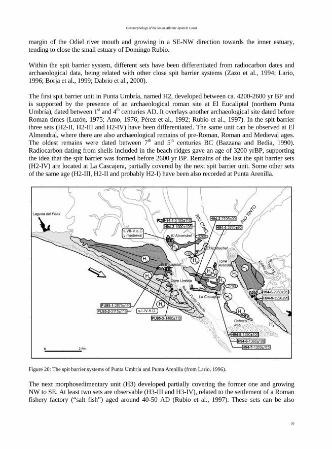
Geomorphology of the South-Atlantic Spanish Coast
30
margin of the Odiel river mouth and growing in a SE-NW direction towards the inner estuary, tending to close the small estuary of Domingo Rubio. Within the spit barrier system, different sets have been differentiated from radiocarbon dates and archaeological data, being related with other close spit barrier systems (Zazo et al., 1994; Lario, 1996; Borja et al., 1999; Dabrio et al., 2000). The first spit barrier unit in Punta Umbría, named H2, developed between ca. 4200-2600 yr BP and is supported by the presence of an archaeological roman site at El Eucaliptal (northern Punta Umbría), dated between 1st and 4th centuries AD. It overlays another archaeological site dated before Roman times (Luzón, 1975; Amo, 1976; Pérez et al., 1992; Rubio et al., 1997). In the spit barrier three sets (H2-II, H2-III and H2-IV) have been differentiated. The same unit can be observed at El Almendral, where there are also archaeological remains of pre-Roman, Roman and Medieval ages. The oldest remains were dated between 7th and 5th centuries BC (Bazzana and Bedia, 1990). Radiocarbon dating from shells included in the beach ridges gave an age of 3200 yrBP, supporting the idea that the spit barrier was formed before 2600 yr BP. Remains of the last the spit barrier sets (H2-IV) are located at La Cascajera, partially covered by the next spit barrier unit. Some other sets of the same age (H2-III, H2-II and probably H2-I) have been also recorded at Punta Arenilla.
Figure 20: The spit barrier systems of Punta Umbría and Punta Arenilla (from Lario, 1996). The next morphosedimentary unit (H3) developed partially covering the former one and growing NW to SE. At least two sets are observable (H3-III and H3-IV), related to the settlement of a Roman fishery factory (“salt fish”) aged around 40-50 AD (Rubio et al., 1997). These sets can be also

F.J. Gracia –Prieto (Coord.)
31
recognised at Saltés Island, where a major number of sets have been preserved. At El Acebuchal only one set corresponding to H3-I or H3-II is recognised. At La Cascajera some beach ridges corresponding to H3-III set have been recognised overlaying the last unit (H2). At Punta Arenillas, unit (H3) partially overlies the last one but no other set has been recognised, probably due to fluvial erosion. The relationship between El Eucaliptal archaeological site and the fishing activity at Punta Umbría ría would support the idea that the spit barrier break took place before 1st Century AD. This would have happened in coincidence with the erosional gap dated between 2700-2400 calBP, that has been associated to a positive sea level pulse during climatic instability or to a destructive event, like a strong storm or a tsunami (Lario, 1996). Unit H4 developed during the last millennium, attached to the former unit and can be observed at Cabezo Alto spit, in Saltés Island. The spit located east of Saltés Island can be correlated with this unit. Torre Umbría is a 17th century watch tower located inland 430 m from the coastline and 1100 m far from the 17th century Punta de la Canaleta site (figure 20). Its present location suggests a rapid progradation rate for unit H4, of about 3 m/yr during that time (Mora Figueroa, 1981; Rubio García et al., 1985; Lario et al., 1995). Three post-flandrian aeolian systems (D) have been identified associated to the spit systems (Borja et al., 1999). The oldest one, D1, accumulated under prevailing WSW winds during the 1st millennium BC, overlays both the occupational horizons of Late Neolithic-Early Copper (4th millennium BC) and the ‘lithic workshop levels’ (4th-2nd millennia BC). The middle dune system D2, containing both Roman and Medieval remains, accumulated between 13th (?)-14th and 17th centuries AD. The youngest D3 system occurs associated to the time of building of watchtowers in 17th century AD but extends to the present; it is related to SW prevailing winds. The absence of aeolian deposits prior to ~2700 calBP is thought to be a result of trapping of a large part of the sediment supply in the estuaries, which starved the neighbouring beaches and aeolian settings. Aeolian accumulation reached significant values when sedimentation in the coastal zone changed from being mainly aggradational in the estuaries to mainly progradational in spit barriers and related dunes, around 2700 calBP. S4.3. Odiel Marshlands: A protected area under human pressure. The salt marshes of the Odiel River experienced great transformations until the early 1980’s. Besides the 1000 ha large salt pans and a big petrochemical complex that required enlarging the Huelva harbour, some other planned, but fortunately unaccomplished, projects would have meant a de-facto destruction of the marshlands. The joint efforts of scientists, ecologists and politicians of the Regional Administration draw worldwide attention on these ecosystems and the need for their preservation. These efforts crystallised in the declaration of the Odiel Marshlands as Reserve of the Biosphere by the MaB Committee of UNESCO in 1983. This action stopped further transformations of the marshlands and allowed the Regional Agency of the Environment to protect the area under the legal statute of Paraje Natural (October 19, 1984). This meant the international recognition of the marshlands as an area essential for the conservation of species and the preservation of their migratory paths. Following protection, biodiversity grew dramatically, and rare or scarce birds such as Calidris sp. (sandpiper), Sterna albifrons (tern), Platalea leucorodia (spoonbill), and a kind of eagle, are now well represented. To answer the expectations vast panoply of plans was required, including redirecting spills and drainage systems, ecological restorations and management of species of
Geomorphology of the South-Atlantic Spanish Coast
32
flora and fauna. It required also programs of public use, environmental education and voluntary actions together with a tuning of the available infrastructures. The Calatilla “Centre of Interpretation” is emblematic of such a transformation. The interest for the Odiel marshlands as the gravity centre of an influence area including not only the coast of Huelva, but also the adjacent Portuguese Algarve, has strengthened the ties between the two nations. It has allowed a better management of nature, tourism, fishery, aquiculture and industry under a perspective of sustainability that is vital to the future of the area. Acknowledgements Financial support from Spanish Projects: BTE2002–1065; BTE2002–1691 and MADRE II REN 2001-1293-C02/HID. This is a contribution to IGCP 495 and to the INQUA “Coastal and Marine Processes” Commission. Chapter III: Geomorphology of the Doñana National Park A. Rodríguez-Ramírez, L. Cáceres and J. Rodríguez-Vidal The Doñana National Park, declared as UNESCO-MAB Biosphere Reserve, is one of the largest wetlands in Europe (50 720 ha) and represents the most important tract of relatively undisturbed marsh in the Iberian Peninsula. It is located in the SW coast of Spain, between coordinates 6º35´00"-6º15´00" W and 36º45´00"-37º10´00" N (Fig. 21). From a geomorphological point of view, it is characterized by the extensive development of coastal and riverine-coastal units associated to the Guadalquivir River estuary (Menanteau, 1979; Rodríguez Ramírez, 1996, 1998). The most significant coastal features are the big sandy barriers, or coastal spits, and the vast dune fields. Regarding sandy barriers, they are originally made up of beach deposits, mostly disfigured by dunes, which tend to close the estuary up in its mouth. The aeolian systems are made up of dune ridges with a large continental and coastal distribution, where a total of five sequences can be distinguished. The riverine-coastal units are represented by the Guadalquivir salt marshes, which fill up the large sector located behind the coastal spits. Extensive tidal flats occupy most part of the Doñana National Park, as a result of gradual accretion and withdrawal of previous marshes during the last 6900 years, with the consequent reduction in the estuary area. III.1. Doñana aeolian systems The Doñana National Park comprises one of the most important aeolian systems in Europe. Geomorphological mapping reveals five sequences of dunes. The oldest three are stable and occupy a considerable area inland. The two more recent ones develop at the coast, are smaller and with frequent overlapping. They are the most distinctive dune complexes and include the presently active dune systems, which cover the most recent littoral units. III.1.1. Stabilized Aeolian Systems These dune systems are the most extensive ones, their maximum development being located in El Abalario area (Fig. 5). After detailed geomorphological mapping, three different systems can be distinguished (Fig. 21), which have been named by chronological order: I, II and III (Rodríguez Ramírez, 1996). These systems are equivalent to units U2, U3 and U4 of Zazo et al. (1999a) in the El Asperillo cliff (see Stop 2).

F.J. Gracia –Prieto (Coord.)
33
System I Located in an aeolian mantle largely transformed by the present superficial flows, it fits a previous relief and shows a very devastated morphology. Nevertheless, some disseminated and scarcely developed parabolic dunes can be observed. These forms may be the result of a subsequent reactivation and they mark an ENE advance direction. As for its chronology, Borja (1997) proposed a correlation with unit U2 of Zazo et al. (1999a), dated by 14C between 31 and 18 Ka BP. System II It is characterized by an extensive dune development with important fronts and by a marked endorheism. The northernmost front reaches heights of up to 76 m. Dunes show winding, slightly parabolic forms, that at some points develop into longitudinal dunes. They generally have a small width (100 m average), whereas their length can be of several kilometers, although without much continuity among the different fronts. As in the previous case, they advance in an ENE direction and their age ranges between 14 and 11.5 Ka BP (Unit 3 by Zazo et al., 1999a). System III It overlaps the previous system and its front is marked by numerous ponds. Dunes present parabolic forms that follow one another, sometimes with a great lateral continuity, shaping a markedly undulating sector. The displacement direction of these dunes varies slightly from E to ENE. Borja (1997) correlates this system with Unit 4 by Zazo et al. (1999a), which shows a chronology between the previous unit (11 Ka) and the Late Neolithic/Calcolithic remains found on its top (5-4 Ka). III.1.2. Active Aeolian Systems Regarding the morphology and disposition of the currently active dunes in this coastal stretch, they can be grouped into two well-defined systems (Fig. 21): IV and V (Rodríguez Ramírez, 1996), which can be correlated with Units 5 and 6 by Zazo et al. (1999a). In both cases, displacements towards the NE with speeds reaching up to 5 m/year have been determined (García Novo et al., 1975). These displacements have made the dunes cover part of the previous systems, as well as the marsh sectors. Both systems extend over both the retrograding sector of this coastal zone (El Asperillo cliff, west of Matalascañas), and the prograding sector (Doñana coastal spit, east of Matalascañas, fig. 5). In the former, smaller size dunes appear aligned and overlapped, with nearly parabolic forms, indicative of a continuous and intense coastal recession. In the second sector, dunes and depressions between fronts are bigger and longer. Genetically, these dunes must be related to the beginning of the last coastal prograding phase that gave rise to coastal spit complexes since the Flandrian transgressive maximum. System IV In this system, dunes located both on El Asperillo cliff and on the Doñana coastal spit (east of Matalascañas) present parabolic forms. In both cases dunes are semi-trapped by vegetation. Those located in Doñana have greater extension, although their size is reduced due to the scarce sand supply. In their displacement towards the NE they left a series of elongated sand structures located in the interdune depressions, locally named “worms”. These “worms” are generated by the anchor effect of vegetation on the backdune and by a water table rise during periods of smaller displacement or no movement. Some advancing dunes have overlied previous marsh sectors and older aeolian systems. In the contact with the latter, a series of frontal ponds are generated by
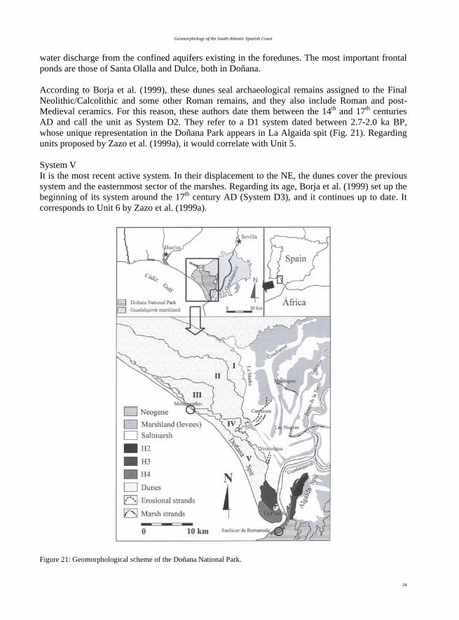
Geomorphology of the South-Atlantic Spanish Coast
34
water discharge from the confined aquifers existing in the foredunes. The most important frontal ponds are those of Santa Olalla and Dulce, both in Doñana. According to Borja et al. (1999), these dunes seal archaeological remains assigned to the Final Neolithic/Calcolithic and some other Roman remains, and they also include Roman and post-Medieval ceramics. For this reason, these authors date them between the 14th and 17th centuries AD and call the unit as System D2. They refer to a D1 system dated between 2.7-2.0 ka BP, whose unique representation in the Doñana Park appears in La Algaida spit (Fig. 21). Regarding units proposed by Zazo et al. (1999a), it would correlate with Unit 5. System V It is the most recent active system. In their displacement to the NE, the dunes cover the previous system and the easternmost sector of the marshes. Regarding its age, Borja et al. (1999) set up the beginning of its system around the 17th century AD (System D3), and it continues up to date. It corresponds to Unit 6 by Zazo et al. (1999a).
Figure 21: Geomorphological scheme of the Doñana National Park.
F.J. Gracia –Prieto (Coord.)
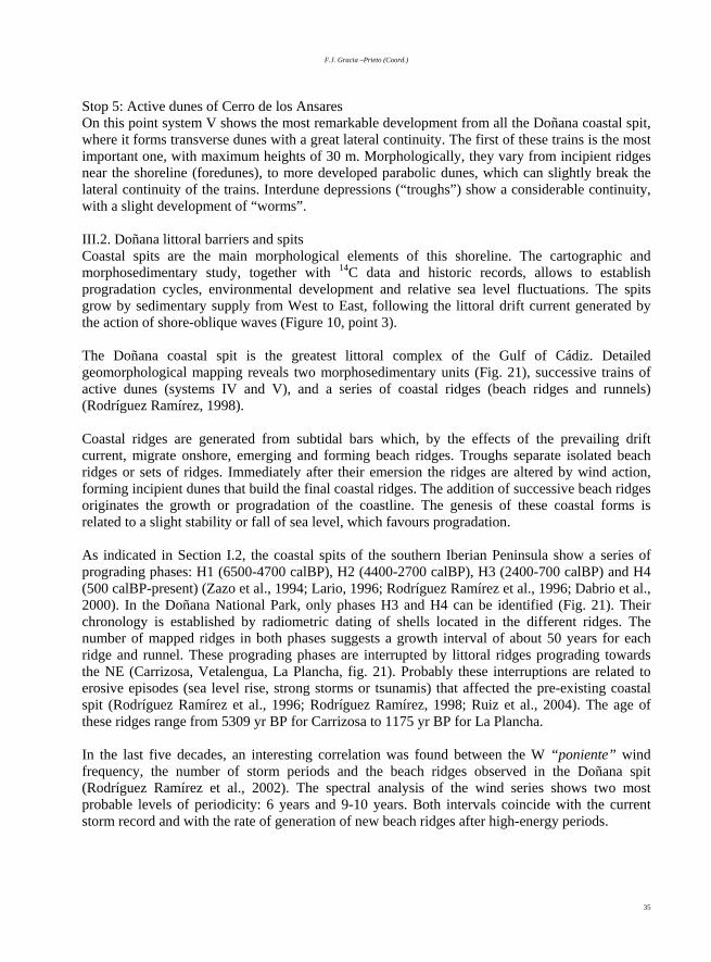
35
Stop 5: Active dunes of Cerro de los Ansares On this point system V shows the most remarkable development from all the Doñana coastal spit, where it forms transverse dunes with a great lateral continuity. The first of these trains is the most important one, with maximum heights of 30 m. Morphologically, they vary from incipient ridges near the shoreline (foredunes), to more developed parabolic dunes, which can slightly break the lateral continuity of the trains. Interdune depressions (“troughs”) show a considerable continuity, with a slight development of “worms”. III.2. Doñana littoral barriers and spits Coastal spits are the main morphological elements of this shoreline. The cartographic and morphosedimentary study, together with 14C data and historic records, allows to establish progradation cycles, environmental development and relative sea level fluctuations. The spits grow by sedimentary supply from West to East, following the littoral drift current generated by the action of shore-oblique waves (Figure 10, point 3). The Doñana coastal spit is the greatest littoral complex of the Gulf of Cádiz. Detailed geomorphological mapping reveals two morphosedimentary units (Fig. 21), successive trains of active dunes (systems IV and V), and a series of coastal ridges (beach ridges and runnels) (Rodríguez Ramírez, 1998). Coastal ridges are generated from subtidal bars which, by the effects of the prevailing drift current, migrate onshore, emerging and forming beach ridges. Troughs separate isolated beach ridges or sets of ridges. Immediately after their emersion the ridges are altered by wind action, forming incipient dunes that build the final coastal ridges. The addition of successive beach ridges originates the growth or progradation of the coastline. The genesis of these coastal forms is related to a slight stability or fall of sea level, which favours progradation. As indicated in Section I.2, the coastal spits of the southern Iberian Peninsula show a series of prograding phases: H1 (6500-4700 calBP), H2 (4400-2700 calBP), H3 (2400-700 calBP) and H4 (500 calBP-present) (Zazo et al., 1994; Lario, 1996; Rodríguez Ramírez et al., 1996; Dabrio et al., 2000). In the Doñana National Park, only phases H3 and H4 can be identified (Fig. 21). Their chronology is established by radiometric dating of shells located in the different ridges. The number of mapped ridges in both phases suggests a growth interval of about 50 years for each ridge and runnel. These prograding phases are interrupted by littoral ridges prograding towards the NE (Carrizosa, Vetalengua, La Plancha, fig. 21). Probably these interruptions are related to erosive episodes (sea level rise, strong storms or tsunamis) that affected the pre-existing coastal spit (Rodríguez Ramírez et al., 1996; Rodríguez Ramírez, 1998; Ruiz et al., 2004). The age of these ridges range from 5309 yr BP for Carrizosa to 1175 yr BP for La Plancha. In the last five decades, an interesting correlation was found between the W “poniente” wind frequency, the number of storm periods and the beach ridges observed in the Doñana spit (Rodríguez Ramírez et al., 2002). The spectral analysis of the wind series shows two most probable levels of periodicity: 6 years and 9-10 years. Both intervals coincide with the current storm record and with the rate of generation of new beach ridges after high-energy periods.

Geomorphology of the South-Atlantic Spanish Coast
36
III.3. Doñana salt marshes The Guadalquivir salt marshes are included within the Doñana National Park and extend over the whole wide palaeoestuary defined by the river mouth and the lower tributaries at both sides of the estuary. During recent historical times the marsh area reached up to 1800 km2, although at present it has been considerably reduced to a small semi-virgin portion due to intensive agricultural activities (Fig. 21). The very low microtopography of these marshlands has great hydrological and ecological relevance because it conditions waterlog, salinity variations and distribution of fauna and vegetation. The natural regime of the present marshes has changed dramatically due to different human activities that have considerably reduced the fresh water supply to the river network. From a geomorphological point of view, two marsh levels can be distinguished (high and low marshes), with a height difference lower than 1 m. The highest topographic zone is located on the high marsh or “pacil” and includes meander bars and overflow bars (levees) of the riverine-tidal courses (Rodríguez Ramírez, 1998). Its genesis is linked to the proper riverine and tidal dynamics. During overflow episodes, the largest sedimentation occurs on the channel margins, so that accretion is faster and builds up levees that isolate the channel from the rest of the plain. For this reason the ‘paciles’ extend over the marsh geography associated with the main river channels. The relatively recent ‘paciles’ present a considerable continuity. However, with time they tend to become eroded by the riverine-tidal dynamics, turning into degraded levees. Finally they originate subrounded or oval morphologies called “vetas”, slightly higher than the bordering relief. It is in these “vetas” where major human settlements are placed, because they are only occasionally inundated during winter floods. The progressive development of overflow and meander bars on the different channels present in the high marsh or “pacil”, delimits a series of closed depressions or “lucios” (Rodríguez Ramírez, 1998). These areas are located far from the riverine-tidal courses and only receive fine sediments during river flooding episodes. Some characteristic features of the most elevated marsh zones are the estuarine ridges or cheniers (Rodríguez Ramírez, 1996, Rodríguez Ramírez et al., 2000, 2001). They are basically made up of shell bars with estuarine fauna, accumulated in the estuary palaeomargins. Given their nature, these bars could be originated by different processes: the interaction of riverine-tidal and drift currents, energetic events (storms, tsunamis) and biological crisis due to environmental changes. They have a large geographical distribution: a first ridge develops in the northern margin (Carrizosa-Marilopez) and to the South a second ridge appears at Vetalengua-Las Nuevas (Fig. 21). These accumulations provide important chronological data because they mark different stages of the coastline position within the estuary evolution. Many 14C dating have been made on these units (Rodríguez Ramírez, 1996; Rodríguez Ramírez et al., 1996; Zazo et al., 1999a; Rodríguez Ramírez, et al., 2000), resulting in ages of 4100 calBP for the northernmost unit and about 2300 calBP for the southern one. Stop 6: Vetalengua strand The geomorphological arrangement of these littoral sedimentary units (normal to the direction of the main barriers) and their small size evidence a short-lived but highly intense erosional event that locally destroyed Doñana spit. 14C dating of this unit gave an age of 2304 yr BP. The main prograding direction of Vetalengua strand is towards the NE - that is, into the estuary. These units overlie earlier marshland deposits at a height of +2 m a.m.s.l. and their morphology reproduce the

F.J. Gracia –Prieto (Coord.)
37
palaeoshoreline for that moment, with a sea level slightly higher than the present one. The energetic event responsible for the accumulation of these units produced a greater estuarine domination within the marsh. Water flow, whatever origin it may have (fluvial, tidal or pluvial), is distributed on the marsh by channel and ”caños”. The former ones are active while the latter are usually inactive, only functioning as partly filled depressions with scarce river flow. The Guadalquivir and Brazo-de-la-Torre rivers are functional and act as waterways and distributors of the tidal currents. The Madre-de-las-Marismas and the Guadalquivir channels only act at present as waterways, especially during rainy periods, without any tidal influence. The Caño Travieso is inactive in the marsh area due to its upstream capture by the Brazo-de-la-Torre channel (Fig. 21). Water contribution of the caños is confined on the marsh borders by the ‘paciles’ associated with the Guadalquivir and the Brazo-de-la-Torre channels. For that reason this marsh acts as a semi-endorheic basin (Rodríguez Ramírez et al., 1997). During rainy years, water surplus surpasses this natural barrier, breaking the respective ‘pacil’ through a series of small streams locally known as ‘rompidos’ or ‘gravetas’ that drain inland and more depressed areas towards the sea. Stop 7: Guadalquivir River mouth. The Guadalquivir River (560 km long) drains a catchment of 57000 km2, comprising mainly Tertiary sedimentary rocks. This river is blocked in its lower reach by sandy barriers, resulting in a large estuary (1800 km2). The Guadalquivir River is the main sediment source of the SW Spanish coast, with a mean annual discharge of 164 m3 s-1. The highest runoff (> 1000 m3 s-1) occurs from January to February, with fluvial wave velocities up to 1 m s-1. The intense fluvial sediment supply helped to continentalize the Guadalquivir estuary and the important sedimentary filling makes the river flow sluggishly. Filling of the estuary was also helped by small, fingered delta bodies (close to the bird-foot type) developed in the main tributaries. Sedimentary filling also creates navigation problems inside the estuary due to decreasing water depth. Periodical dredging of the estuary bottom is needed for maintaining the intense cargo ship traffic up to Seville harbour. Wave fronts incoming the estuary from the W and NW suffer complex modifications due to refraction processes along the northern shoreline and also to reflection on the southern cliffed shoreline. As a consequence, different erosion and accretion zones appear in the northern coast. Retreating zones are represented by vertical cliffs on dunes and by several historical bunkers fallen down onto the shoreface. Accreting zones are represented by a system of very recent beach ridges and swales that have grown during the last decades (Fig. 22). Their growing rate is related to the alternation of cyclonic and anticyclonic periods and establishes two different frequencies: one around 3-7 years and another one of 10-12 years. The former is related to short-term climatic events (NAO), while the latter is associated to less intense sunspot activity. The alternation of winter cyclonic regimes and summer anticyclonic regimes favours the generation and growing of the beach ridges (Rodríguez Ramírez et al., 2000). III.4. Geomorphological evolution of Doñana National Park The development and evolution of the Doñana National Park and its surroundings is linked to the last great-scale postglacial sea level rise (Flandrian transgression). The maximum sea level height was reached about 6500 years ago (Zazo et al., 1994), followed by a nearly stillstand until present.

Geomorphology of the South-Atlantic Spanish Coast
38
As a consequence, a rapid and important coastal recession took place along this stretch of the Iberian South Atlantic coast. This coastal retreat generated cliff zones even within estuaries, favoured by the prevailing soft lithology of outcropping materials at the coast and by wave action. As a consequence, the coastline evolved to an uneven coast with large inlets, as a result of the marine invasion of coastal lowlands and fluvial valleys and with abrupt headlands formed on watershed areas (Fig. 23 A and B).
Figure 22: Beach ridges and swales developed on the northern shoreline of the Guadalquivir estuary, determined by photointerpretation of different images between 1956 and 1996 (Rodríguez Ramírez et al., 2000). 1, previous materials; 2, beach ridges; 3, major swales. From then on, coastal dynamics is producing a progressive coastline regularisation by the infill or sealing of inlets and headland erosion. The different sedimentary units that filled these inlets represent coastal responses to the Late Holocene climatic and sea level oscillations. As a consequence, a series of prograding and erosive phases can be reconstructed within the Guadalquivir estuary (Zazo et al., 1994; Rodríguez Ramirez, 1996). The first two phases took place at a regional scale between during Flandrian maximum (6500 - 4400 yr BP) and between 4200 and 2550 yr BP (Figs. 23 B – D), although there is not any direct evidence in this sector. The third phase (2300 - 800 yr BP) and the fourth and last one (500 yr BP-present) were separated by successive erosive episodes between 4400-4200 yr BP, 2550-2300 yr BP and 800-500 yr BP (Figs. 23 E – H). These recent prograding phases are represented by Carrizona, Vetalengua and La Plancha ridges (Rodríguez Ramírez, 1998). In this sense, major erosive cycles can be established with approximate frequencies of about 2000 and 1000 years, where slight sea level rises produced important ruptures of pre-existing coastal forms, as well as marked cliff retreats. These erosive events were characterised by an intensification of the prevailing drift current, with important sediment transport related to periods of greater atmospheric instability within the general anticyclonic domain, or due to catastrophic events (tsunamis).

F.J. Gracia –Prieto (Coord.)
39
Figure 23: Geomorphological evolution of the Doñana National Park (Rodríguez Ramírez et al., 1996).

Geomorphology of the South-Atlantic Spanish Coast
40
High sea water level periods not only produced coastal erosion on sandy coasts, but also greater marshland flooding, resulting in a greater development of malacofauna characteristic of these mixed brackish/fresh water environments. Inversely, prograding phases lead to a decrease of marine influence within the estuary, a prevalence of continental environments and an increase of the fluvial dynamics in relation to marine processes. This environmental change could have been responsible for biological crises in the estuary and subsequent bioclastic accumulation in the estuary palaeomargins in the form of cheniers (Rodríguez Ramírez et al., 1996). The progressive sedimentary filling of the estuary occurred following the fingered delta model for shallow areas not very affected by swell waves. With the exception of the Brazo-de-la-Torre channel, the very limited efficiency of most channels to drain the marshes (La Madre, Guadiamar, Travieso) hinders their water discharge into the Guadalquivir River. For this reason, the recent evolution of the marshes shows an increase in the number of endorheic basins, many of them confined by the levee (‘pacil’) of the Guadalquivir River. Fluvial overflows only occur during winter floods and are distributed through small “caños”. Moreover, tides are at present confined to the Guadalquivir course and, to a lower extent, to the Brazo-de-la-Torre channel, favouring the extension of freshwater communities within the zone. Sedimentary filling has been undoubtedly intensified by human activity, that began 2000 yr ago, and especially during the last century. Given the present intense agricultural activities around the channels draining the marshes, sedimentary processes are especially important, with a loss of topographic unevenness. As a direct consequence, a lower water retention capacity, higher water salinity and a redistribution of living organisms is taking place. Finally, in the last decades the construction of walls and artificial caños, especially in the northern margin, has deeply transformed the natural hydrological circulation. Chapter IV: Historical evolution and erosion problems in the Cadiz Coast. F.J. Gracia, C. Alonso, G. Anfuso, J. Benavente, L. Del Río, L. Domínguez and J.A. Martínez IV.1. Coastal erosion problems in the Cádiz coast Apart from current sea-level rise trends (Menanteau and Clemente, 1977), the most important cause for beach erosion in the Gulf of Cádiz is related to the role of dams and reservoirs in the fluvial basins, which trap sediments and substantially reduce sediment supply (Del Río et al., 2002). Spanish hydraulic policy in the 1960’s and 1970’s led to the construction of tens of dams in the main fluvial catchments of the zone: Guadiana, Guadalquivir and Guadalete rivers. As a direct consequence, coastline retreat was initially slow in the 1970’s but progressively accelerated during the 1980’s, leading to widespread coastal erosion. The different amount of coastal retreat along this coast usually depends on local factors, like wave shoaling processes (Muñoz and Enríquez, 1998), human interventions, etc. Coastal progradation trends are restricted to small pocket beaches or to the accumulative side of some jetties (Benavente et al., 2005c). Many coastal areas, especially in the western and central zones of the Huelva coast, have suffered frequent human interventions by means of jetties, groins and harbours, that have significantly altered the coastal dynamics, producing erosion (Ballesta et al., 1998). Near the Guadiana River mouth, González et al. (2000) recognised important coastline changes related to the construction of jetties. These structures led to sand starvation that resulted in severe erosion of large prominent
F.J. Gracia –Prieto (Coord.)
41
parts of the coast between 1956 and 1994. Part of the eroded sand accumulated against other jetties and re-entrant portions located eastwards the Guadiana River mouth, resulting in a coastline straightening. One of the most spectacular examples of erosional effects of engineering structures is the 10 km long Juan-Carlos-I groin, made in 1981 near Huelva town (Flores et al., 1997; Rodríguez-Ramírez et al., 1999). It completely blocks littoral currents, producing erosion along more than 25 km downdrift. In the 2000-2001 winter the structure induced a beach retreat of 10-20 m. Mazagon beach, protected in the shadow zone of the groin, exhibits little erosion and only suffers important retreating episodes during the most energetic storms, like the one of January 1996, that produced a set-back of 30 m in a few days. Dune ridges usually lessen the erosive effects of storms. When they are destroyed for urbanization purposes, associated beaches erode more easily and sedimentary budget becomes negative. This type of actuation produces significant variations in the retreating behaviour of beaches. Exposed natural beaches present very different behaviour during the actuation of a single energetic event (Reyes et al., 1999). This is due to the relative quantity of sand existing in the coastal system. Some beaches contain an amount of sand big enough for attaining different morphodynamic states along the year, well adapted to the changing energetic conditions. In these cases beaches usually experience small retreats during winter energetic episodes (Benavente et al., 2002). Erosion processes produce a certain beach flattening and profiles assume quite dissipative designs. During fair weather conditions, sedimentary recovery in these beaches is faster and almost complete, by the progressive arrival of subtidal bars and the acquisition of intermediate to reflective profiles (Benavente et al., 2000). The western beaches of Huelva coast follow this behaviour. In contrast, other beaches lacking enough sand for a change in the morphodynamic state, have not this autodefensive response and suffer more intense erosive processes (Benavente et al., 2005a; Anfuso et al., 2001). In the present section two examples are presented illustrating local beach erosion problems at very different environments: a tourist beach on a growing urban area and a natural beach located on a preserved natural park. Both cases are located around the Bay of Cádiz, which constitutes a good example for the comparison of long and short-term erosional data. The zone has an additional interest due to its high socio-economic and naturalistic importance. Coastal erosion studies in the zone are being carried out by the Group of Coastal and Marine Geology and Geophysics of the University of Cádiz since the middle 1990’s. From a methodological point of view, the study comprises two different types of data. First, recent historical records and aerial photographs give data about coastal evolution in the last decades. Second, periodical beach monitoring gives an idea of the rate at which erosion takes place at present. Although erosive tendencies and rates vary notably along the Bay of Cádiz and surrounding areas, beach volumetric trends at the medium term show a general prevalence of sand loss in the northern beaches, between Cádiz and Chipiona cities (Fig. 24). According to the morphodynamic classification proposed by Masselink and Short (1993), along the Cádiz Bay beach profiles range from intermediate-reflective to dissipative and even ultradissipative states. The ability of beaches to recover after storm events depends on the sand availability to complete a morphodynamic change, that is, to sufficiently adapt their profiles to the new energetic conditions. As a consequence, seasonal beaches, characterised by an alternation between two or more states through the year, are more resistant to storms than uniform unchanging beaches. In the Cádiz Bay there is not a great dependency on the specific prevailing morphodynamic state (Benavente et al., 2002), although intermediate-reflective beaches (Fig.

Geomorphology of the South-Atlantic Spanish Coast
42
25a) are more vulnerable to erosion than whole-year whole-year dissipative ones (Fig. 25b), and ultradissipative profiles (Fig. 25c) are most resistant ones.
Figure 24. Beach volumetric trends in the Cádiz Bay and surrounding areas. Data were averaged after a monthly beach topographic monitoring program between 1996 and 2001. Stop 8: Coastal erosion at La Ballena beach Coastal retreat between Sanlúcar-de-Barrameda and Rota villages was investigated by estimating the erosion/accretion rates recorded in the 1956-2001 period (Fig. 26). High erosion rates were observed in the Sanlúcar-Chipiona sector (3 m/yr, Figure 4), due to different factors. These include great cliff erodibility (outcropping materials are composed of Quaternary sands and silts), coastline orientation (which makes it be exposed to storms arriving from the NW) and diminution of sedimentary supplies from the Guadalquivir River (Domínguez et al., 2005). Lesser retreat rates (0.6 to 2.4 m/yr) were also recorded in beaches backed by dunes at Punta Camarón and

F.J. Gracia –Prieto (Coord.)
43
Punta Candor (Fig. 26) and also in the narrow beaches backed by silt cliffs at Tres Piedras and La Ballena (erosion rates ranging betwee 0.5 and 1.5 m/yr).
Figure 25. Average beach profile changes recorded before and after storm events in three different environments in the Cádiz Bay and surrounding areas. Five coastal vulnerability types (“very high”, “high”, “medium”, “low” and “null to very low”) were obtained by combining the potential cliff (or dune) retreat/stability and land use type. Land uses include four main categories: “dense urbanization”, “scatter occupation”, “croplands” and “recreational and naturalistic zones” (Fig. 26). At present more than one third of the littoral is at risk, with very high vulnerability to erosion at Sanlúcar-de-Barrameda due to the important capital land use in combination with high retreating rate. The rest two thirds of the studied coast present low or very low risk. The obtained results were used to calculate the future 15 yr coastline, which is the hypothetical position of coastal line in 15 years, taking into account the recorded erosion rate (Crowell et al., 1999). In the Sanlúcar-Chipiona sector the 15 yr coastline is projected 45 m landward of the actual cliff top or dune base. La Ballena beach is located between Chipiona and Rota beaches. At present it constitutes a very important tourist point where urban areas have grown very rapidly in the last years. Beach retreat rates at this beach, measured from seven different aerial photographs between 1992 and 2001, give an average value of 1.3 m/yr, although recent trends suggest and acceleration of the process (1.9 m/yr). The urban complex complies with the current Spanish Shore Act, which defines a public zone 100 m wide where no stable construction should be placed. However, the 15 yr predicted coastline includes all the recently urbanised areas. The first zones that will be affected by erosive processes essentially consist of recreational areas, promenades, parking areas and small buildings (restaurants and bars). Rip-rap revetments have been often used for coastal defence in local and near similar cases, although it seems not to be a very effective measure and rather nourishment projects –accompanied by the construction of small engineering structures- should be planned to solve existing erosion problems at this beach.

Geomorphology of the South-Atlantic Spanish Coast
44
Figure 26. Morphological features, erosion rates, land uses and coastal vulnerability of the northern Cádiz coast (Domínguez et al., 2005).
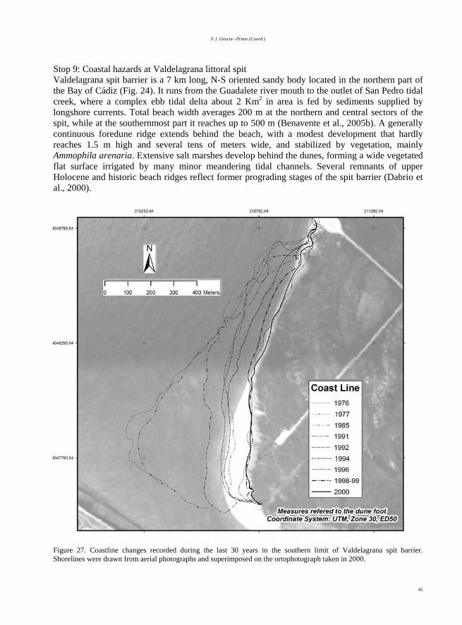
F.J. Gracia –Prieto (Coord.)
45
Stop 9: Coastal hazards at Valdelagrana littoral spit Valdelagrana spit barrier is a 7 km long, N-S oriented sandy body located in the northern part of the Bay of Cádiz (Fig. 24). It runs from the Guadalete river mouth to the outlet of San Pedro tidal creek, where a complex ebb tidal delta about 2 Km2 in area is fed by sediments supplied by longshore currents. Total beach width averages 200 m at the northern and central sectors of the spit, while at the southernmost part it reaches up to 500 m (Benavente et al., 2005b). A generally continuous foredune ridge extends behind the beach, with a modest development that hardly reaches 1.5 m high and several tens of meters wide, and stabilized by vegetation, mainly Ammophila arenaria. Extensive salt marshes develop behind the dunes, forming a wide vegetated flat surface irrigated by many minor meandering tidal channels. Several remnants of upper Holocene and historic beach ridges reflect former prograding stages of the spit barrier (Dabrio et al., 2000).
Figure 27. Coastline changes recorded during the last 30 years in the southern limit of Valdelagrana spit barrier. Shorelines were drawn from aerial photographs and superimposed on the ortophotograph taken in 2000.
Geomorphology of the South-Atlantic Spanish Coast
46
Human settlements are important in the northern portion of the spit, covering about 2 km of the spit lenght, and are represented by a tourist complex constructed during the 1970’s. At present, the salt marshes, beaches and dunes southwards of the urbanized area are included in the Bay of Cadiz Natural Park. Recent evolution of the spit has been assessed by accurate photointerpretation techniques, which reveal a general trend of coastal retreat, progressively greater towards the southern spit limit, where important coastal changes have taken place in the last years. No significant variations were recorded between 1956 and 1976, but from then on a continuous coastline retreat was produced, in which several erosive pulses can be differentiated (Fig. 27). Two main erosive episodes took place in 1976-77 and in 1984-85, with average retreat rates of 37.8 m/yr for the first period (reaching 89.13 m/yr at some points) and 13.13 m/yr for the second one. These episodes coincide with the construction and lengthening of the Guadalete mouth jetties, which produce and injection of the sediment supplied by Guadalete River to the outer Bay of Cadiz, isolating the spit from its main sedimentary input. As a general rule, episodes of strong retreat are followed by periods several-years long during which coastline tends to stabilise, until the next erosive pulse. However, near the southernmost point, shoreline erosion pulses are so fast and intense that there is not time enough for the coastline to reach stability. As a consequence, total shoreline retreat in this area between 1956 and 2000 is clearly visible on aerial photographs and amounts to 562 m (Martínez-del-Pozo, et al., 2001). One of the consequences of such severe coastal erosion in Valdelagrana spit relates to the increase in its vulnerability to coastal inundation due to storms. A study of flooding hazard in the area was performed by combining topographic measurements of spit morphology, theoretic calculations of storm surge elevations and detailed analysis of recent spit evolution (Benavente et al., 2005b). Results show the variability in the degree of protection of the spit against storm-induced inundation according to the different geomorphological features existing on it: changes in intertidal beach slope, nearshore morphology, presence and characteristics of dune ridges, etc. This way, the dune ridge demonstrates to be enough for effectively protecting the coast against modal storms (with recurrence interval of about 1 year and Hmax of 3.3 m). In case of severe storms (recurrence interval of about 8-10 years and Hmax of 10.6 m), gentle nearshore slopes like that of ebb tidal delta at the southernmost point could theoretically protect the areas behind the beach and dunes. However, shoreline retreat moves the extent of inundated areas landward and deteriorates the dune ridge, so in the southernmost part of the spit the exposure to storm waves causing flooding hazard is increased due to coastal erosion (Benavente et al., 2005b). The resulting hazard map (Fig. 28) shows the consequences of current coastal retreat in the distribution of flooded areas in the forthcoming years. IV.2. Historical evolution of the Cadiz coast Historical evolution of the Cádiz coast reveals important transformations, especially on sedimentary coastal zones. During the last 2000 years different phases of beach development and coastal progradation alternated with erosive periods, producing sets of historical beach ridges that can be observed at favourable places along this coast. The application of different methods like geomorphological mapping, radiocarbon dating and geoarchaeological exploration on such sedimentary systems has allowed to reconstruct the historical evolution of several Cádiz coastal zones, like Valdelagrana spit (Zazo et al., 1994; Dabrio et al., 2000), Bolonia Bay (Alonso et al., 2003a) and Los Lances Bay (Gracia et al., 2004). In some cases relationships have been proposed among coastal evolution phases, sea level oscillations and climatic changes (Zazo et al., 1996; Lario, 1996). In other historical cases, very rapid erosive episodes were associated to a higher
F.J. Gracia –Prieto (Coord.)
47
frequency of storm events, or to catastrophic tsunami waves, both producing important changes that conditioned the later coastal evolution. The present section includes two examples of erosive processes that deeply transformed the coast during historical times.
4047600 4047800 4048000 4048200 4048400
208600
208800
209000
209200
209400
209600
209800
210000
210200
210400
Emerged areasin modal storms
Washover
Dune flattening
Emerged areasin extreme storms
Figure 28. Flood hazard map of Valdelagrana spit barrier (Benavente et al., 2005b). Stop 10: Historical tsunami record at Cape Trafalgar As previously cited in section I.1, the Gulf of Cádiz is subject to a certain seismic activity focused on the plate boundary between Eurasia and Africa South of Cape San Vicente. Historically this activity has produced very important earthquakes, although with a long return period. Some of these earthquakes derived in very energetic tsunamis that affected all the coastal regions in the Gulf of Cádiz, resulting in important damages and coastal transformations. The most recent tsunami was produced by the Lisbon-earthquake, that took place on the 1st November 1755 and generated waves 10 m high at Cádiz city (Campos, 1992). Historical tsunami records along this coast are mainly represented by high-energy deposits within estuarine sequences and by huge overwash fans located at places inland never reached by present storm waves (Luque et al., 2001, 2002; Gracia et al., 2004; Rodríguez Ramírez et al., 2004). Cape Trafalgar is an outstanding point where very spectacular records of the 1755 tsunami can be observed. 50 years after this event, this
Geomorphology of the South-Atlantic Spanish Coast
48
zone was also witness of the famous naval battle where the British Army, commanded by Admiral Nelson, defeated the combined French-Spanish Army led by Napoleon’s commander, Villeneuve.
Figure 29. Geomorphological map and cross section of Cape Trafalgar (Gracia et al., 2000). Legend: 1, Pleistocene substratum; 2, beaches; 3, rock platform; 4, block revetment; 5, fixed dunes; 6, mobile dunes; 7, wooden fences for trapping aeolian sands; 8, aeolian sheet; 9, permanent ponds; 10, ephemeral ponds; 11, overwash fan; 12, ancient lagoon filled up by sediments; 13, vegetation cover; 14, escarpment; 15, roads and buildings; 16, lighthouse.

F.J. Gracia –Prieto (Coord.)
49
Cape Trafalgar is a double tombolo of about 1 km length between Conil and Barbate villages. The rocky island, up to 20 m high, is constituted by a basal Pleistocene beach level formed by conglomerates and laminated sandstones, dated by Zazo et al. (1999) as Ouljian (U/Th 107 +/- 2 ka) and located about 1 m above m.s.l. This deposit is slightly tilted to the NW and is affected by several sets of crossed fractures and joints. A very laminated aeolianite overlies the beach deposit and forms the main body of the island. The SE border of the island is rimmed by a rocky shore platform 100 m wide excavated on the Pleistocene beach level. The island is connected to land by two sand barriers and an intermediate lagoonal zone presently filled by fine sediments and covered by aeolian sand sheets and dunes (Fig. 29). The western barrier (Zahora beach) is exposed to the Atlantic wave fronts and during extreme storm events it occasionally records wave heights of up to 4 m high which produce overwashes. The eastern barrier (Caños de Meca beach) develops on a sheltered area and is only affected by very low energy refracted waves, with heights always lower than 1 m, even during storm events. The Trafalgar tombolo includes tsunami deposits at different heights, all of them consisting in accumulations of boulders and imbricated blocks, very similar to other tsunami deposits described in Australia (Young et al., 1996; Nott, 2003) or in Cyprus (Kelletat and Schellmann, 2002). Three different accumulations can be distinguished (Alonso et al., 2004): 1) Imbricated big blocks.- The aeolianite substratum in the southern island slope is covered by a pile of rounded and flat blocks and boulders constituted by cemented sands and gravels from the Pleistocene beach level. Block thickness fluctuates between 0.2 - 0.5 m and show a diameter between 0.3 - 1.5 m. They form up to four parallel boulder ridges, the highest one extending on a wide cornice at about 6 m above m.s.l. No present storm wave, nor its associated run up, ever reaches such a height. Blocks usually dip 6º seawards and are imbricated with long axes parallel to shore. The deposit shows a clear grading, with maximum height and diameter diminishing eastwards, until they disappear in the eastern side of the island. A mill wheel of probable Roman age was found inserted in between these blocks. The wheel supposedly belonged to a nearby Roman salt-fishery plant (Fig. 30) and would support the very recent age of this block deposit. 2) Boulders on the rock platform.- More than 50 scattered boulders lie on the platform up to 150 far from the coastline, all of them roughly rectangular, at about 1 m above m.s.l. Most of them are more than 1 m in thickness and between 2-4 m in length. All of them come from the underlying Pleistocene beach and the joints affecting the beachrock favoured their rectangular form. Scheffers and Kelletat (2003) cited these boulders as typical tsunami deposits and estimated for them an average weight of 90 t. Some of the boulders show a lower side with littoral karren (mainly phytokarren microforms) with peaks and pinnacles oriented downwards, while the upper side shows a planar clean surface lacking any dissolution form. Such a disposition suggests that during their transport by the tsunami waves some boulders were tossed and today they appear upside down. The size and density of the boulders diminishes from West to East, towards the more sheltered eastern zone, where the platform lacks any boulder and many bioconstructional forms appear well preserved and protected from wave action. 3) Block field.- The entire sandy zone behind the island shows many minor angular blocks that commonly do not exceed 0.4 m in length. Although mostly covered by aeolian dunes along the northern side of the island, they outcrop under the beach in the eastern side of the tombolo and form a dense block field about 100 m wide (Fig. 30). No evident imbrication can be observed, and

Geomorphology of the South-Atlantic Spanish Coast
50
some of them are constituted by Roman constructional remains coming from the salt-fishery plant.
Figure 30. Tsunami records in Cape Trafalgar (Alonso et al., 2003). Legend: 1, Pleistocene substratum; 2, escarpment; 3, gentle slope; 4, imbricated big blocks; 5, rock platform with scattered boulders; 6, block field; 7, beaches and dunes; 8, ponds; 9, overwash fan; 10, remains of a Roman salt-fishery plant; F, lighthouse. Arrow indicates the main approaching direction of waves associated to the 1755 tsunami. The three groups of blocks and boulders are associated to a very energetic wave transport that cannot be explained by present storm waves. Their disposition suggests that all of them were probably deposited by a single tsunami event. Nevertheless, following Young et al. (1996), the multimodal distribution of block sizes can be indicative of different pulses within a single tsunami event. Block imbrication and distribution clearly evidence tsunami wave provenance from the WSW (Fig. 30). The island acted as a boat bow and its planform favoured wave refraction and flow diversion at both island sides. The SW side was the most exposed one to tsunami waves and blocks from the beachrock reached the highest altitudes, covering most part of the southern island slopes. Tsunami wave refraction around the rocky shore platform would have reduced wave energy along the SE side of the island. However, the steep slopes surrounding the outer border of the shore platform would have focused wave impact on the platform-submerged walls, producing huge boulders that were transported some distance and finally deposited upon the rock platform. In the more sheltered northern side the tsunami flow would have completely swept the sand barrier and accumulated blocks with sizes diminishing eastwards, presently buried by aeolian sands. The easternmost side of the island constituted a shadow zone where no block deposit has

F.J. Gracia –Prieto (Coord.)
51
been identified; nevertheless, tsunami refracted waves also affected this zone and produced severe damage on the ancient Roman salt-fishery plant. Present energetic storms produce coalescent washover fans along the western tombolo side. They affect the incipient dune ridges and form a sandy and gravely tongue that seldom reaches the road to the lighthouse (Fig. 30). Stop 11. Historical evolution of Bolonia Bay The Bolonia Bay is located within the NW side of the Campo de Gibraltar zone, where disperse tectonic blocks of Miocene sandstones appear overlying a soft Mesozoic substratum formed by folded marls and clays. At the coast this structural disposition draws an alternation of rocky headlands and small bays with strong morphostructural control, submitted to recent (even historical) vertical tectonic movements (Zazo et al., 1999; Ménanteau et al., 1983). The prevailing littoral drift towards the SE makes all these bays acquire a typical Z-planform, usually controlled by rocky capes at their updrift limits. The littoral current has produced the development of longitudinal sand bodies along the bays, while the diminishing tidal range towards the Strait has favoured the closing of the small lagoons developed behind the littoral beach ridges and spits. Bolonia Bay, with 3.5 km of coastline front, is one of the most outstanding bays in the Gibraltar Strait, because it hosts the well-preserved remains of the historical Roman city Baelo Claudia. This roman city was historically placed at this point due to the geostrategic situation of the Bay, at the entrance of the Gibraltar Strait (Alonso and Navarro, 1999). It was founded at the end of II century b.C., possibly as a pre-Roman settlement. In the I and II centuries a.D. Baelo Claudia was a flourishing city, raised to the statement of Roman municipality by the emperor Claudius. It included a theatre, public baths, a market and a wide forum, appearing today as a magnificent example of ancient Spanish-Roman city. Its decline probably began at the end of the II century and was accentuated by the dramatic consequences of a destructive earthquake that affected the zone in the III century (Borja et al., 1993). Many pop-up like structures and other damages observable in the remains were interpreted by Goy et al. (1994) and Silva et al. (2000) to have a seismogenic origin. From that moment and during the whole IV century, the urban area considerably diminished. The city was progressively abandoned and the last record of occupation dates back to the VII century. From the beginning of the 1920’s many archaeological excavations have been developed in the remains (Sillières, 1995) and in 1989 the city was declared as Archaeological Site of Interest by the Council of Culture of the Andalusia Regional Government. Today it is one of the most exceptional examples of cultural legacy from the ancient Roman times in the Iberian Peninsula. The historical classical texts describe Baelo Claudia as a harbour and a commercial city with important traveller transport in transit to northern Africa (Strabo, 3.4.8). The traditional historical-archaeological research never focused on the real harbour facilities of this settlement and always supposed that ancient roman ships could easily anchor in the western side of the Bay, probably helped by some auxiliary wooden jetty. However, the strong and persistent winds and the physiography of the bay do not favour navigation activities at all (París et al., 1923; Martín, 1988; Alonso and Navarro, 1999). Perhaps at that time the city harbour included artificial structures for shelter and facilities for ship loading. Or perhaps during that epoch the coastal morphology was different from the present one and showed more favourable conditions for navigation purposes. In order to solve all these questions, the Andalusian Institute for Historical Heritage (belonging to the Andalusian Regional Government) and the archaeological team of the Baelo Claudia site

Geomorphology of the South-Atlantic Spanish Coast
52
faced a multidisciplinary research project between 1999 and 2001 (Alonso et al., 2003a) with the aim of reconstructing the ancient coastline and city harbour and their later evolution. The project included geomorphological mapping, several geophysical surveys, borehole drilling and new archaeological excavations. The Roman city is partly limited seaward by a middle Holocene marine terrace (Ménanteau et al., 1983; García de Domingo et al., 1990) at about 3 m a.m.s.l. that connects with fluvial deposits associated to two lateral small river courses. The Holocene barrier isolates an ancient lagoon filled up with clays (Fig. 31). The eastern fluvial valley develops a vegetated marsh plain on a shelter area close to its mouth. After excavating this clay deposit, a sandy bioclastic level was identified and dated by radiocarbon, giving an age of cal. 2150-1825 yr BP (Alonso et al., 2003a). The nature and location of such a deposit, similar to other overwash deposits recognised along the Cádiz coast, suggest the occurrence of a marine energetic episode between II b.C. and III a.D. centuries. Other Holocene bioclastic estuarine deposits appear near the present river mouth and were dated by 14C between 1600 and 1900 yr BP, suggesting the persistence of a protected coastal plain up to the III century.
Figure 31. Location of Baelo Claudia Roman city and main geomorphological features of Bolonia Bay (Alonso et al., 2003a).

F.J. Gracia –Prieto (Coord.)
53
Despite the existence of some geophysical data taken on the Roman city between 1964 and 1994, new and systematic electromagnetic surveys were carried out in 1999 along the seaward side of the city. The geophysical prospecting revealed several anomalies possibly related to architectural structures buried under the present beach sands. Later high-resolution geoelectric surveys, carried out on the beach by the Laboratoire Géolittomer (LETG - UMR 6554, C.N.R.S. – University of Nantes), showed two clear lineal resistivity anomalies, one of them extended from the main city street toward the sea (Fig. 32). Another more detailed electric survey was focused upon the second resistivity anomaly and it revealed a buried rigid in situ structure. Archaeological excavation of this zone allowed to discover an ancient harbour block-ramp, seaward oriented and partly covered by fluvio-littoral gravels (Fig. 33, above). To the East such a ramp appeared destroyed and flattened by storm wave action. Other varied harbour structures, like small groins, walls normal to the shoreline and block platforms, were also dug up along the seaward side of the city (Fig. 33, below).
Figure 32. Two straight NNE-SSW oriented geoelectrical anomalies appear under the Bolonia beach sediments in front of Baelo Claudia salt-fishering archaeological structures Data obtained from geophysical survey carried out in September 2000. Apparent electrical resistivity values expressed in � m-1. Contour lines in m (from differential GPS). Georeferences: UTM 30.
Geomorphology of the South-Atlantic Spanish Coast
54
Figure 33. Archaeological excavations verified the nature of the geoelectric anomalies under the present beach sands. Above, harbour ramp with a regular slope affected by marine erosion; below, port platform and walls. Four boreholes were drilled along the beach in front of the city (see fig. 31 for location). Figure 34 shows stratigraphical records of the cores, all of them reaching the pre-Holocene substratum. A 3 m thick deposit of paludal clays overlie Upper Cretaceous grey marls, with a growing thickness to the East (drills S-3 and S-4). This unit suggests the existence of an ancient coastal lagoon, presumably protected from the marine action by some kind of sand barrier. Afterwards, a

F.J. Gracia –Prieto (Coord.)
55
continuous level of fluvial gravels containing constructive roman remains indicates a coastal progradation phase and/or the filling of the coastal lagoon by fluvial-littoral sediments. The radiocarbon dating of a sample taken within this level gave an age of 3850 yr BP. After roman times intense coastal erosion has removed other possible deposits and has produced important damage on part of the roman structures. The outer sand barrier has already disappeared and at present only disperse archaeological remains appear on the nearshore zone and under the narrow presently-retreating sandy beach.
Figure 34. Sedimentary record under present beach sands from five cores taken on the backshore in front of Baelo Claudia city (see fig. A for location). Legend: 1, present beach and aeolian sands; 2, fluvial-littoral sands and gravels; 3, fluvial gravels; 4, fine gravels on a clay matrix; 5, greenish and brown clays; 6, Cretaceous grey marls (Alonso et al., 2003a). All these data indicate a complex evolution of the Bolonia Bay during the last millennia and help to reconstruct its recent geomorphological history. Starting from the Frandrian eustatic maximum, where a beach barrier isolated a coastal lagoon presently filled up with sediments and artificially drained, a certain sea level fall ended in a sea level stabilisation around its present height about 4000 years ago. At that moment a second generation of coastal beach barrier developed and generated a coastal lagoon fed by two small rivers and probably connected to the sea by an inlet. This protected lagoon favoured the setting of the roman city and offered especial facilities for anchoring, which resulted in the construction of a stable harbour ramp probably helped by auxiliary wooden groins (Fig. 35). The coastal lagoon probably persisted until the III century a.D. (Alonso et al., 2003b)

Geomorphology of the South-Atlantic Spanish Coast
56
This palaeogeographical situation began to change during the roman times. The overwash deposit found in the coastal marshes to the SE of the ancient city (Fig. 35), dated around the end of the II century a.D., suggests a quite energetic marine event, capable to cross the coastal lagoon and accumulate debris on this shelter area. However, it is difficult to relate this deposit to a specific marine process. Several destructive earthquakes affected the zone during roman times, some of them producing destructive tsunamis at the coast (Luque et al., 2002). The approximate coincidence between the age of the overwash deposit and the earthquake that destroyed Baelo Claudia suggests the possibility of a tsunami as the main responsible for the disappearance of the beach barrier and for part of the damage that affected the most exposed zones of the city. However, a higher frequency of storms in the Atlantic European coasts between the XI and XVI centuries (Lamb, 1982) could have resulted in an accelerated erosion and local overwash processes in the Gulf of Cádiz coast. Further research is needed to solve this question.
Figure 35. Palaeogeographical reconstruction of the ancient harbour at Baelo Claudia during roman times. Legend: 1, inactive cliff; 2, archaeological structures; 3, salt fishery remains; 4, eroded salt fisheries; 5, anchoring places; 6, harbour structures (ramp, groins); 7, overwash deposit; 8, disperse roman constructive blocks (Alonso et al., 2003a). In recent times, intense beach erosion has produced the removal of sands down to the roman harbour structures. Many ancient constructive blocks are displaced from their original positions and at present rest upon fluvial-littoral levels of the last lagoon phase. Nevertheless, exposed roman structures lying above 3 m a.m.s.l. still remain in situ, although strongly damaged. At present the beach surface shows an intermediate to high slope that makes it quite vulnerable to energetic waves. The beach width oscillates yearly more than 20 m, but a clear retreating rate of about 1 m/yr has been recorded during the last years. Morphological consequences of such a trend are the persistence of vertical escarpments on dunes and a beach topography lowering that can be

F.J. Gracia –Prieto (Coord.)
57
estimated in more than 2 m in the western sector of the bay during the last two decades. At present many roman structures are exposed to wave action and in recent years the Baelo Claudia archaeological team had to retreat the outer protective fences, which in turn weakened the already eroded dunes of the central beach sector. Stop 12. Valdevaqueros Bay and dunes In the vicinity of the Gibraltar Strait strong winds coming from the SE (levante) often produce important sand transport from beaches. As a consequence, extensive aeolian sand sheets develop covering the slopes and lowlands surrounding the western sides of the bays. During such levante wind storm events, littoral drift currents in the Strait are directed to the NW and transport part of the aeolian sands to the nearby embayments. This process involves a substantial sediment supply to the bays and supposes a significant component in the sedimentary budget of all these beaches. However, aeolian sand transport in this zone has historically produced several problems to traffic, houses and different human activities developed near the coast, especially those related to the military use of the main capes and headlands near the Strait. In order to minimise all these effects, in the late 1950’s several attempts were made to trap aeolian sand: installation of fence lines, reafforestation of pine forests, etc. (Ménanteau et al., 1983). As a consequence, no more aeolian sediment was transported to the bays and their sedimentary budget was broken towards coastal erosion (Fig. 36).
Figure 36. Aeolian sand transport was blocked in the late 1950’s by artificially increasing pine forest areas and other sand trap measures. Two comparative examples are shown, for Bolonia Bay and Point Paloma-Valdevaqueros, between 1956 (vertical aerial photographs on the left) and 2000 (oblique aerial photos on the right).

Geomorphology of the South-Atlantic Spanish Coast
58
Another consequence of such interventions was the generation of huge mobile dunes in Trafalgar, Bolonia and Valdevaqueros bays. Some of them soon reached more than 30 m high, with a well-developed slip face. The mobile dune at Valdevaqueros Bay – Point Paloma is one of the most spectacular examples of the Gibraltar Strait great dunes, where most attempts made in the last years for stopping its advance have failed (Fig. 37). At present, the main interventions consist in a periodical removal of sand from the slip face and its later distribution upon the beach.
Figure 37. Geomorphological map of Valdevaqueros Bay (Gracia et al., 2000). Legend: 1, pine forest; 2, beach; 3, fixed dunes; 4, mobile dunes; 5, dune slip face; 6, dune crest; 7, fences for aeolian sand trapping; 8, coastal lagoon; 9, salt marshes; 10, river floodplain; 11, escarpment; 12, gully; 13, roads and paths; 14, buildings; 15, block revetment. Acknowledgements This is a contribution to DIVULGA Research Project (BTE2003-05706, supported by the Spanish Ministry of Science & Technology and by European ERDF) and to the Andalusian PAI Research Group no. RNM - 328.
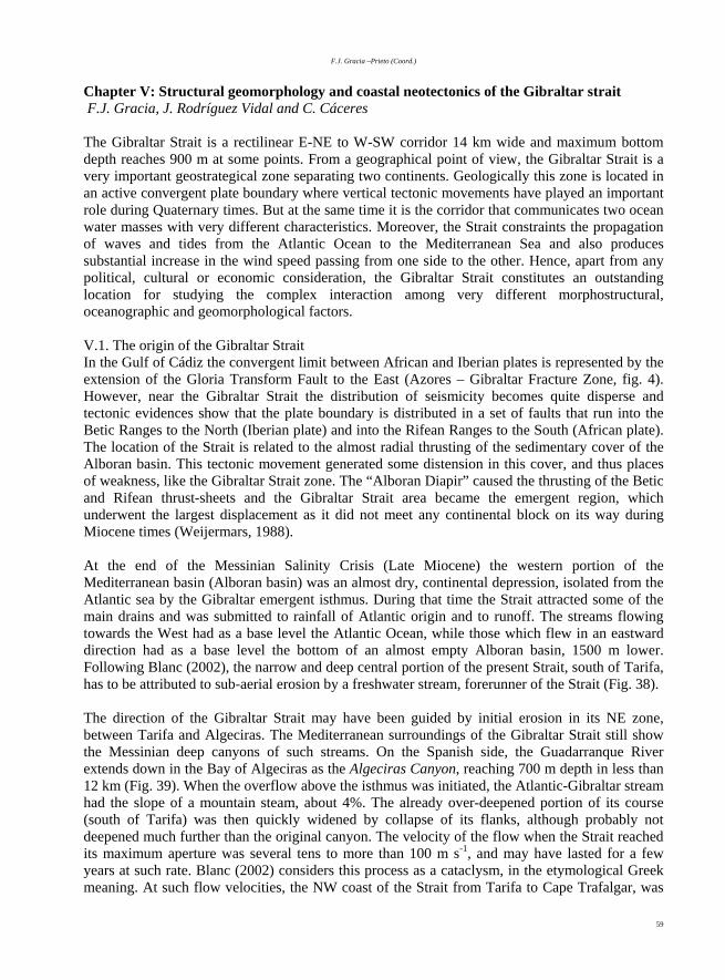
F.J. Gracia –Prieto (Coord.)
59
Chapter V: Structural geomorphology and coastal neotectonics of the Gibraltar strait F.J. Gracia, J. Rodríguez Vidal and C. Cáceres The Gibraltar Strait is a rectilinear E-NE to W-SW corridor 14 km wide and maximum bottom depth reaches 900 m at some points. From a geographical point of view, the Gibraltar Strait is a very important geostrategical zone separating two continents. Geologically this zone is located in an active convergent plate boundary where vertical tectonic movements have played an important role during Quaternary times. But at the same time it is the corridor that communicates two ocean water masses with very different characteristics. Moreover, the Strait constraints the propagation of waves and tides from the Atlantic Ocean to the Mediterranean Sea and also produces substantial increase in the wind speed passing from one side to the other. Hence, apart from any political, cultural or economic consideration, the Gibraltar Strait constitutes an outstanding location for studying the complex interaction among very different morphostructural, oceanographic and geomorphological factors. V.1. The origin of the Gibraltar Strait In the Gulf of Cádiz the convergent limit between African and Iberian plates is represented by the extension of the Gloria Transform Fault to the East (Azores – Gibraltar Fracture Zone, fig. 4). However, near the Gibraltar Strait the distribution of seismicity becomes quite disperse and tectonic evidences show that the plate boundary is distributed in a set of faults that run into the Betic Ranges to the North (Iberian plate) and into the Rifean Ranges to the South (African plate). The location of the Strait is related to the almost radial thrusting of the sedimentary cover of the Alboran basin. This tectonic movement generated some distension in this cover, and thus places of weakness, like the Gibraltar Strait zone. The “Alboran Diapir” caused the thrusting of the Betic and Rifean thrust-sheets and the Gibraltar Strait area became the emergent region, which underwent the largest displacement as it did not meet any continental block on its way during Miocene times (Weijermars, 1988). At the end of the Messinian Salinity Crisis (Late Miocene) the western portion of the Mediterranean basin (Alboran basin) was an almost dry, continental depression, isolated from the Atlantic sea by the Gibraltar emergent isthmus. During that time the Strait attracted some of the main drains and was submitted to rainfall of Atlantic origin and to runoff. The streams flowing towards the West had as a base level the Atlantic Ocean, while those which flew in an eastward direction had as a base level the bottom of an almost empty Alboran basin, 1500 m lower. Following Blanc (2002), the narrow and deep central portion of the present Strait, south of Tarifa, has to be attributed to sub-aerial erosion by a freshwater stream, forerunner of the Strait (Fig. 38). The direction of the Gibraltar Strait may have been guided by initial erosion in its NE zone, between Tarifa and Algeciras. The Mediterranean surroundings of the Gibraltar Strait still show the Messinian deep canyons of such streams. On the Spanish side, the Guadarranque River extends down in the Bay of Algeciras as the Algeciras Canyon, reaching 700 m depth in less than 12 km (Fig. 39). When the overflow above the isthmus was initiated, the Atlantic-Gibraltar stream had the slope of a mountain steam, about 4%. The already over-deepened portion of its course (south of Tarifa) was then quickly widened by collapse of its flanks, although probably not deepened much further than the original canyon. The velocity of the flow when the Strait reached its maximum aperture was several tens to more than 100 m s-1, and may have lasted for a few years at such rate. Blanc (2002) considers this process as a cataclysm, in the etymological Greek meaning. At such flow velocities, the NW coast of the Strait from Tarifa to Cape Trafalgar, was

Geomorphology of the South-Atlantic Spanish Coast
60
undermined and collapsed into the axial channel, forming a gravity nappe, soon broken into smaller outliers. This interpretation explains the present dissymetry of the Strait, deep and narrow towards the Mediterranean, wide, shallow and irregular towards the Atlantic.
Figure 38. The Gibraltar Waterfall (conceived by Guy Billout, in Brown et al., 1989). Finally, the Pliocene transgression rapidly filled the Mediterranean with Atlantic water that overflowed the isthmus at all. The transgression is considered to be instantaneous at a geological scale: it is assumed that lasted probably less than 1000 years. Moreover, from an oceanographic point of view some authors consider that only 36 days would be needed to fill an empty Mediterranean, even when taking into account the evaporation (Hsü et al., 1973; Bethoux, 1980). Stop 13. The Gibraltar Strait from the Puerto del Cabrito The central northern side of the Strait is constituted by a rectilinear portion 20 km long from Tarifa to Punta Carnero, or 27 km to the Rock of Gibraltar. From this panoramic point the northern African coast can be perfectly distinguished as well as the dense shipping traffic between the Mediterranean Sea and the Atlantic Ocean. Water interchange between both ocean masses consist in a deep outflow of the warm and dense (highly saline) Mediterranean water and a shallow inflow of the cold and less dense Atlantic water into the Mediterranean Sea (Gascard and Richez, 1985). Total water flux through the Strait has been evaluated in more than 100 x 1012 m3/yr (Bethoux, 1980). V.2. Neotectonics and Quaternary evolution of the Gibraltar Rock The Rock of Gibraltar is a North-South peninsula with the eastern side being very steep and a gentler western slope. It constitutes a tombolo of small area, with 5.2 km length, 1.6 km width and about 6 km2 in total land area. Topographically and geologically (Fig. 40 - A) it is divisible into three main zones (Rose and Rosembaum, 1991): a) de Isthmus, a low-lying sandy plain less than

F.J. Gracia –Prieto (Coord.)
61
3 m a.m.s.l., which represents Holocene sediments that join the northern Gibraltar Rock to the mainland, b) the Main Ridge, which forms a sharp crest with peaks over 400 m a.m.s.l. formed by Early Jurassic limestones and dolomites, and c) the Southern Plateau, a staircased slope between 130 m and present sea level. Steep cliffs fringe this plateau at its Mediterranean margin. Surface topography is primarily the result of Quaternary wave-cut erosion and the fringing cliffs are product of shoreline processes.
Figure 39. Present bottom physiography of the Gibraltar Strait (Vázquez, 2001). Stop 14. The Gibraltar Rock from Atunara Beach At this point we can see a broad view of the Mediterranean side of the Gibraltar Rock. The Gibraltar landforms are formed by two main groups of processes (Rodríguez-Vidal and Gracia, 1994, 2000): i) the tectonic movements that determine the general shape and ii) surface erosional and depositional processes that have acted on the uplifted rocks. Coastal processes have been especially active in the eastern face of the Rock, exposed to a greater fetch. The combination of tectonic and eustatic fluctuations have caused change in the location of the coastal landforms, which has controlled the evolution of slopes. Lithification of the Quaternary deposits led to the preservation of a varied group of sediments that indicate a rapid and complex geomorphological development and neotectonic uplift history. Indeed, features of the Quaternary geology of Gibraltar have excited interest since the mid-18th century. Vertebrate faunas from bone breccias in caves and fissures were prolific and stimulated early work. The findings include the discovery of a Neanderthal cranium in Forbes’ Quarry in 1848 and the fragmented cranium of a Neanderthal child in Devil’s Tower Rock Shelter in 1926. Cave deposits (Fig. 40 - B) have been subject of a series of excavations during the past 130 years and sedimentary sequences on some of them (like

Geomorphology of the South-Atlantic Spanish Coast
62
Gorham’s and Vanguard caves) cover a timescale commencing in the Last Interglacial and concluding with historical Phoenician/Carthaginian remains (Rodríguez-Vidal et al., 2004). Quaternary sediments on Gibraltar flanks have a widespread distribution and are both marine and continental deposits. They include sand and cobble shore sediments, aeolian sands, scree breccias, and karstic products, like clays, fallen rocks and speleothems. Tectonic uplift of marine highstands shows raised shorelines staircased across the Gibraltar slopes. Geomorphological research brought about by Rodríguez-Vidal et al. (2004) indicates that the relationships between beach, scree and dune sedimentary formations form five main morphotectonic steps on the Rock (Fig. 40 - B): marine terraces between 1 and 25 m (e.g. Gorham’s Cave), 30-60 m (e.g. Europa Flats), 80-130 m (e.g. Windmill Hill Flats), 180-210 m (e.g. Martin’s Cave) and other features above this level. Each terrace succession and associated slope-aeolian sediments is backed by a steep relict sea cliff along its landward margin, so forming a composite cliff (Rodríguez-Vidal and Gracia, 2000). The cliffs appear much better developed on the eastern side of the Rock, exposed to much more energetic waves than the western side. The higher morphotectonic steps are older than the lower ones and probably formed in the Early Pleistocene.
Figure 40. A: Simplified geomorphological map of the Gibraltar Peninsula (Rodríguez Vidal and Gracia, 1994): 1, scarps and ancient cliffs; 2, structural surface upon limestones and dolomites; 3, isthmus sands; 4, scree breccias; 5, aeolian sands; 6, rasided beaches and wave-cut platforms; 7, recent beaches; 8, fill and made ground; 9, contours at 100 m intervals. B: Simplified morphotectonic map of the Gibraltar Rock (Rodríguez Vidal et al., 2004). 1 – 5, staircased morphotectonic units (MTU 1 – 5), older to recent, separated by an escarpment or palaeocliff; 6, reclaimed land.
A B
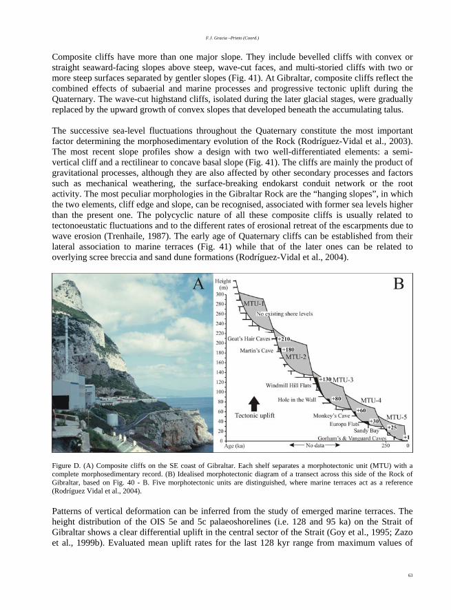
F.J. Gracia –Prieto (Coord.)
63
Composite cliffs have more than one major slope. They include bevelled cliffs with convex or straight seaward-facing slopes above steep, wave-cut faces, and multi-storied cliffs with two or more steep surfaces separated by gentler slopes (Fig. 41). At Gibraltar, composite cliffs reflect the combined effects of subaerial and marine processes and progressive tectonic uplift during the Quaternary. The wave-cut highstand cliffs, isolated during the later glacial stages, were gradually replaced by the upward growth of convex slopes that developed beneath the accumulating talus. The successive sea-level fluctuations throughout the Quaternary constitute the most important factor determining the morphosedimentary evolution of the Rock (Rodríguez-Vidal et al., 2003). The most recent slope profiles show a design with two well-differentiated elements: a semi-vertical cliff and a rectilinear to concave basal slope (Fig. 41). The cliffs are mainly the product of gravitational processes, although they are also affected by other secondary processes and factors such as mechanical weathering, the surface-breaking endokarst conduit network or the root activity. The most peculiar morphologies in the Gibraltar Rock are the “hanging slopes”, in which the two elements, cliff edge and slope, can be recognised, associated with former sea levels higher than the present one. The polycyclic nature of all these composite cliffs is usually related to tectonoeustatic fluctuations and to the different rates of erosional retreat of the escarpments due to wave erosion (Trenhaile, 1987). The early age of Quaternary cliffs can be established from their lateral association to marine terraces (Fig. 41) while that of the later ones can be related to overlying scree breccia and sand dune formations (Rodríguez-Vidal et al., 2004).
Figure D. (A) Composite cliffs on the SE coast of Gibraltar. Each shelf separates a morphotectonic unit (MTU) with a complete morphosedimentary record. (B) Idealised morphotectonic diagram of a transect across this side of the Rock of Gibraltar, based on Fig. 40 - B. Five morphotectonic units are distinguished, where marine terraces act as a reference (Rodríguez Vidal et al., 2004). Patterns of vertical deformation can be inferred from the study of emerged marine terraces. The height distribution of the OIS 5e and 5c palaeoshorelines (i.e. 128 and 95 ka) on the Strait of Gibraltar shows a clear differential uplift in the central sector of the Strait (Goy et al., 1995; Zazo et al., 1999b). Evaluated mean uplift rates for the last 128 kyr range from maximum values of

Geomorphology of the South-Atlantic Spanish Coast
64
0.15 mm/yr, at Tarifa, to lower values of 0.10 mm/yr in the Mediterranean coast. The calculated mean rate for the Gibraltar Rock is about 0.05 +/- 0.01 mm/yr during the last 100 ka (Lario, 1996). Zazo et al. (1999b) inferred that differential uplift and subsidence along the coast of the Strait was mainly set along individual faults. Major faults interacting with the coast have NE-SW and NW-SE directions and they mainly work as strike-slip faults separating crustal blocks with different associated uplifting or subsiding character. After taking into account the vertical distribution of different levels associated to the Gibraltar composite cliffs, Rodríguez-Vidal et al. (2004) inferred uplift rates of about 0.33 +/- 0.05 mm/yr, which represent a logical consequence of the uplift rate curve on Gibraltar coast (Fig. 42), where the OIS 1, 5 and 7 shorelines have been compared with their present heights. An old uplift rate of 0.33 +/- 0.05 mm/yr was calculated at least to 250 kyr, possibly compatible with major tectonic events in response to a NNW-SSE compressive stress field. Afterwards, from 200 ka to the present, lower uplift value of about 0.05 +/- 0.01 mm/yr characterises the most recent trends.
Figure 42. Mean rates of tectonic uplift of the Gibraltar Rock in the last 250 ka (Rodríguez-Vidal et al., 2004). Thick black bars represent height and age of different terrace shore deposits identified in the zone by several authors. Acknowledgements This work is a contribution to the PALAEOMED project (Interreg IIIB of the EU MEDOC Programme, 2002-02-4.1-U-048).

F.J. Gracia –Prieto (Coord.)
65
Referentes:
Aguirre, J. (1995). Implicaciones estratigráficas y paleogeográficas de
dos discontinuidades estratigráficas en los depósitos pliocenos de
Cádiz (SW de España). Revista de la Sociedad Geológica de
España, 8, 153 – 166.
Alonso, A.M., Armenteros, I.; Braga, J.C., Muñoz, A., Pujalte, V. and
Ramos, E. (coords.)(2002). Tertiary. In: The Geology of Spain (W.
Gibbons and T. Moreno, eds.), The Geological Society, London,
293 – 334.
Alonso, C., Gracia, F.J., Del Río, L., Anfuso, G., Benavente, J. and
Martínez, J.A. (2004). Registro morfosedimentario de eventos
históricos de alta energía en el litoral atlántico del Estrecho de
Gibraltar (Trafalgar – Tarifa). In: Contribuciones recientes sobre
Geomorfología (G. Benito and A. Díez, eds.), SEG and CSIC,
Madrid, 263 – 271.
Alonso, C., Gracia, F.J., Ménanteau, L., Ojeda, R., Benavente, J. and
Martínez-del-Pozo, J.A. (2003a). Paleogeographie de l’anse de
Bolonia (Tarifa, Espagne) à l’époque romaine. In: The
Mediterranean World. Environment and History (E. Fouache, ed.).
Elsevier SAS, Paris, 407 – 417.
Alonso, C. and Navarro, M. (1999). Baelo Claudia: sus posibilidades
portuarias y la navegación por el Estrecho de Gibraltar. In: III
Jornadas de Arqueología Subacuática. Reunión Internacional
sobre puertos antiguos y comercio marítimo: Valencia, 133-140.
Alonso, C., Ojeda, R., Ménanteau, L. and Gracia, F.J. (2003b). Análisis
geoarqueológico del sector meridional de Baelo Claudia (Tarifa,
Cádiz). PH Boletín del Instituto Andaluz del Patrimonio Histórico, 43,
58-74.
Amo, M.-del (1976). Restos materiales de la población romana de
Onuba. Huelva Arqueológica, II: 24
Anfuso, G., Benavente, J. and Gracia, F.J. (2001). Morphodynamic
responses of nourished beaches in SW Spain. Journal of Coastal
Conservation, 7, 71 – 80.
Ballesta, M., Morales, J.A. and Acosta, E.A. (1998). Efecto erosivo de
los temporales del invierno 1995-1996 sobre la playa de Mazagón
(Huelva, SO España): influencia de las construcciones costeras.
Revista de la Sociedad Geológica de España, 11 (3-4), 285 – 296.
Bard, E., Rostek, F., Turon, J.L. and Gendreau, S. (2000).
Hydrological impact of Heinrich events in the subtropical northeast
Atlantic. Science, 289, 1321–1324
Bazzana, A. and Bedia, J. (1990). Excavación de Saltés (Huelva).
Consejería de Cultura y Medio Ambiente de la Junta de Andalucía.
Anuario Arqueológico de Andalucía. 1990, 252-257.
Benavente, J. (2000). Morfodinámica litoral de la Bahía Externa de
Cádiz. PhD Thesis. Universidad de Cádiz, 534 p. (unpublished).
Benavente, J., Anfuso, G., Del Río, L., Gracia, F.J. and Reyes, J.L.
(2005a). Evolutive trends of nourished beaches in SW Spain.
.Journal of Coastal Research, S.I. 39 (in press).
Benavente, J., Del Río, L., Anfuso, G., Gracia, F.J. and Reyes, J.L.
(2002). Utility of morphodynamic characterisation in the prediction
of beach damage by storms. Journal of Coastal Research, S.I. 36,
56 – 64.
Benavente, J., Del Río, L., Gracia, F.J. and Martínez-del-Pozo, J.A.
(2005b). Coastal flooding hazard related to storms and coastal
evolution in Valdelagrana spit (Cadiz Bay Natural Park, SW
Spain). Continental Shelf Research (in press).
Benavente, J., Gracia, F.J., Anfuso, G. and López-Aguayo, F. (2005c).
Temporal assessment of sediment transport from beach
nourishments by using foraminifera as natural tracers. Coastal
Engineering, 52, 205 – 219.
Benavente, J., Gracia, F.J. and López-Aguayo, F. (2000). Empirical
model of morphodynamic beachface behaviour for low-energy
mesotidal environments. Marine Geology, 167, 375 – 390.
Bethoux, J.P. (1980). Mean water fluxes across sections in the
Mediterranean Sea, evaluated on the basis of water and salt budgets
and on observed salinties. Oceanologica Acta, 3 (1), 79 – 88.
Blanc, P.L. (2002). The opening of the Plio-Quaternary Gibraltar
Strait: assessing the size of the cataclysm. Geodinamica Acta, 15,
303 – 317.

Geomorphology of the South-Atlantic Spanish Coast
66
Borja, C. (in prep). Humedales litorales: génesis y evolución.
Caracterización geomorfológica y ecodinámica de los humedales
del Manto Eólico Litoral de El Abalario-Doñana (Huelva). PhD
Thesis, University of Sevilla.
Borja, C., Díaz del Olmo, F., Cámara, R. and Borja, F. (2003). Fases
del sistema palustre Holoceno del Manto Eólico Litoral de
Abalario-Doñana (MELAD). In: Actas de la XI Reunión Nacional
de Cuaternario (G. Flor, ed.), University of Oviedo, 117-122.
Borja, F. (1992). Geosistemas lagunares en el litoral de Huelva: los
complejos húmedos de El Abalario (entorno de Doñana). Huelva en
su Historia, 4, 63-103.
Borja, F. (1997). Dunas litorales de Huelva (SW de España). Tipología
y secuencia Pleistoceno superior-Holoceno; In: Cuaternario Ibérico
(J. Rodríguez Vidal, ed.). AEQUA, University of Huelva, 84-97.
Borja, F. and Díaz del Olmo, F. (1994). El acantilado de El Asperillo:
Cuaternario reciente y fases históricas en el litoral de Huelva.
Geogaceta, 15, 101–104.
Borja, F. and Díaz del Olmo, F. (1996). Manto eólico litoral (MEL) de
El Abalario (Huelva, España): Episodios morfogenéticos
posteriores al 22.000 BP. In: Dinámica y Evolución de Medios
Cuaternarios (A. Pérez Alberti, A.P. Martini, W. Chesworth and A.
Martínez, eds.), Xunta de Galicia, Santiago de Compostela, 375–
390.
Borja, F., García, J.M., Castiñeira, J., Gómez, F. and Campos, J.
(1997). Cuaternario reciente y poblamiento prehistórico del litoral
acantilado de El Asperillo (Huelva). Setúbal Arqueológica, 11/12,
39-48.
Borja, F., Martines, A. and Troya, A. (1993) . El proceso histórico de
destrucción de la ciudad romana de Baelo Claudia (SW Cádiz).
Caracterización geotécnica y análisis de formaciones superficiales.
In: Seminario de Arqueología y Etnología Turolense. Arqueología
Espacial, 16-17, Teruel, p. 297 – 308.
Borja, F., Zazo, C., Dabrio, C.J., Diaz del Olmo, F., Goy J.L. and
Lario, J. (1999). Holocene aeolian phases and human settlements
along the Atlantic coast of southern Spain. The Holocene, 9.3, 333-
339.
Borrego, J. (1992). Sedimentología del estuario del río Odiel, Huelva,
SW España. PhD Thesis. Universidad de Sevilla, 308 p.
(unpublished).
Borrego, J., Ruiz, F., González-Regalado, M.L., Pendón, J.G. and
Morales, J.A. (1999). The Holocene transgression into the estuarine
central basin of the Odiel River mouth (Cadiz gulf, SW Spain):
lithology and faunal assemblages. Quaternary Science Reviews, 18,
796-788.
Boski, T., Moura, D., Veiga-Pires, C., Camacho, S., Duarte, D., Scott,
D.B. and Fernández, S.G. (2001). Postglacial sea-level rise and
sedimentary response in the Guadiana Estuary, Portugal/Spain
border. Sedimentary Geology, 150, 103-121.
Brown, J., Colling, A., Park, D., Phillips, J., Rothery, D. and Wright, J.
(1988). The ocean basins: Their structure and evolution.
Oceanography Series (G. Bearman, ed.), Pergamon Press and The
Open University, Oxford, 171 pp.
Buforn, E. and Udías, A. (1991). Focal mechanisms of earthquakes in
the Gulf of Cádiz, South Spain and Alborán Sea. In: Seismicity,
Seismotectonics and Seismic Risk of the Ibero-Maghrebian Region
(J. Mezcua and A. Udías, eds.) Instituto Geográfico Nacional,
Monografía nº 8, Madrid, 29 – 40.
Cáceres, L.M. (1999). Geomorfología del sector occidental de la
depresión del Guadalquivir (Huelva). Servicio de Publicaciones de
la Universidad de Huelva. Colec. Alonso Barba, 5, 250 pp.
Campos, M.L. (1992). El riesgo de tsunamis en España. Análisis y
valoración geográfica. Monogr. I.G.N. 9, Madrid, 204 pp.
CMA (2002). Plan Andaluz de Humedales. Consejería de Medio
Ambiente, Junta de Andalucía. 253 pp.
Coleto (2003). Funciones Hidrológicas y biogeoquímicas de las
formaciones palustres hipogénicas de los mantos eólicos de El
Abalario. PhD Thesis, University Complutense of Madrid. 461 pp.
(unpubl.).
Crowell, M., Leikin, H. and Buckley, M. (1999). Evaluation of coastal
erosion hazards study: an overview. Journal of Coastal Research,
SI 1, 2-9.

F.J. Gracia –Prieto (Coord.)
67
Dabrio, C.J., Borja, F., Zazo, C., Boersma, R.J., Lario, J., Goy, J.L. and
Polo, M.D. (1996). Dunas eólicas y facies asociadas pleistocenas y
holocenas en el acantilado de El Asperillo (Huelva). Geogaceta, 20,
1089–1092.
Dabrio, C.J., Zazo, C., Goy, J.L., Sierro, J., Borja, F., Lario, J.,
Gonzalez J.A. and Flores, J.A. (2000). Depositional history of
estuarine infill during the last postglacial transgression (Gulf of
Cadiz,Southern Spain). Marine Geology, 162, 381-404.
Dabrio, C.J., Zazo, C., Lario, J., Goy, J.L., Sierro, F.J., Borja, F.,
Gonzalez, J.A. and Flores, J.A. (1999). Sequence stratigraphy of
Holocene incised-valley fills and coastal evolution in the Gulf of
Cadiz (southern Spain). Geol. Mijnbouw, 77, 263-281.
Del Río, L., Benavente, J., Gracia, F.J., Anfuso, G., Martínez-del-Pozo,
J.A., Domínguez, L., Rodríguez-Ramírez, A., Flores, E., Cáceres,
L.M., López-Aguayo, F. and Rodríguez-Vidal, J. (2002). The
quantification of coastal erosion processes in the South Atlantic
Spanish coast: methodology and preliminary results. Proc. 6th
Intern. Conf. LITTORAL'2002. Eurocoast. Porto, Vol. 2, p. 383 –
390.
Domínguez, L., Anfuso, G. and Gracia, F.J. (2005). Vulnerability
assessment of a retreating coast in SW Spain. Environmental
Geology, (in press).
Flores, E. and Rodríguez Vidal, J. (1994). Rasgos morfotectónicos del
interfluvio costero Guadiana–Guadalquivir (Golfo de Cádiz). In:
Geomorfología en España (J. Arnáez, J.M. García Ruiz and A.
Gómez, eds.), S.E.G., Logroño, 13–19.
Flores, E., Rodríguez-Vidal, J., Ballesta, M., Rodríguez-Ramírez, A.
and Cáceres, L.M. (1997). Cambios morfológicos actuales en la
playa de Mazagón (Huelva). In: Cuaternario Ibérico (J. Rodríguez-
Vidal, ed.), AEQUA, Huelva, 154 – 156.
García de Domingo, A., González, J., Hernáiz, P.P., Zazo, C., Goy,
J.L. and Moreno, F. (1990). Mapa geológico de la Hoja
1.073/1.076: Vejer de la Frontera. Mapa Geológico de España, E.
1:50.000, Instituto Geológico y Minero de España, Madrid, 43 pp.
García Novo, F., Ramírez, L. and Torres, A. (1975). El sistema de
dunas de Doñana. Naturalia Hispánica, 5, 56 pp.
Gascard, J. and Richez, C. (1985). Water Masses and Circulation in the
Western Alboran Sea and in the Straits of Gibraltar. Progress in
Oceanography, 15, 157-216.
González, R., Alveirinho-Dias, J.M. and Ferreira, O. (2000). Altering
the natural balance of sedimentation and its consequences: recent
evolution of the Guadiana Delta (SW Iberian Peninsula). In: 3º
Simposio sobre a Margem Ibérica Atlántica, Faro, Portugal, 125 –
126.
Goy, J.L., Zazo, C., Dabrio, C.J. and Lario, J. (1994). Fault–controlled
shifting shorelines in the Gulf of Cadiz since 20 KyBP. 1st
Symposium Atlantic Iberian Continental Margin. Abstracts
Volume, Lisboa.
Goy, J.L., Zazo, C., Dabrio, C.J., Lario, J., Borja, F., Sierro, F. and
Flores, J.A. (1996). Global and regional factors controlling changes
of coastlines in southern Iberia during the Holocene. Quaternary
Science Reviews, 15 (3-4), 1-8.
Goy, J.L., Zazo, C., Mörner, N.A., Hoyos, M., Somoza, L., Lario, J.,
Bardají, T., Silva, P.G. and Dabrio, C. J. (1994). Pop-up like
deformation of a Roman floor and liquefaction structures in SW
Spain as possible paleoseismic indicators. Bull. INQUA Neot.
Comm., 17, 42 - 44.
Goy, J.L., Zazo, C., Silva, P.G., Lario, J., Bardají, T. and Somoza, L.
(1995). Evaluación geomorfológica del comportamiento
neotectónico del Estrecho de Gibraltar (Zona Norte) durante el
Cuaternario. IV Coloquio Internacional sobre el enlace fijo del
Estrecho de Gibraltar. SECEG, Madrid, 51 – 69.
Gracia, F.J., Alonso, C., Martínez, J.A., Del Río, L., Anfuso, G. and
Benavente, J. (2004). Evolución geomorfológica holocena e
histórica de la Ensenada de Los Lances (Tarifa, Cádiz). In:
Procesos geomorfológicos y evolución costera (R. Blanco, J. López
y A. Pérez Alberti, eds.). II Reun. Geomorf. Litoral, Univ. de
Santiago de Compostela, 145, 255 - 269.
Gracia, F.J.; Benavente, J.; Alonso, C.; Reyes, J.L., García, C.M. and
Hernández, I. (2000). Geomorfología de la costa atlántica gaditana.
In: Geomorfología Litoral. Procesos Activos (J.R. de Andrés and
F.J. Gracia, eds.), I.T.G.E. and Univ. Cádiz, 235 – 255.

Geomorphology of the South-Atlantic Spanish Coast
68
Hayes, M.O. (1979). Barrier-island morphology as a function of tidal
and wave regime. In: Leatherman, S.L. (Ed.), Barrier Islands from
the Gulf of St. Lawrence to the Gulf of Mexico. Academic Press,
New York, p. 1-27.
Hernández Molina, F.J., Somoza, L., Rey, J. and Pomar, L. (1994).
Late Pleistocene Holocene sediments on the Spanish continental
shelves: Model for very high resolution sequence stratigraphy.
Marine Geology, 120, 129-174.
Hsü, K.J., Cita, M.B. and Ryan, W.B.F. (1973). The origin of the
Mediterranean environments. Initial Report of the Deep Sea
Drilling Project, vol. 13, US Government Print. Office,
Washington, 1203 – 1235.
Instituto Hidrográfico de la Marina (1991). Derrotero nº 2 – Tomo 2.
Costas de Portugal y SO de España. Ministerio de Defensa, Cádiz.
ITGE (1990). Introducción, Guadalquivir – Golfo de Cádiz. In:
Documentos sobre la geología del subsuelo de España. Instituto
Tecnológico Geominero de España, Madrid.
Kelletat, D. and Schellmann, G. (2002). Tsunamis on Cyprus: field
evidences and 14C dating results. Zeitschrift für Geomorphologie,
46 (1), 19 – 34.
Labourdette, D., Coleto, C., Bravo, M.A., Borja, F. and Montes, C. (in
press). Formaciones palustres de los Mantos Eólicos y Flecha
Litoral de El Abalario-Doñana. Cartografía 1:60.000. Consejería
Medio Ambiente. Junta de Andalucía.
Lamb, H.H. (1982). Climate, history and the modern world. Methuen
London.
Lario, J. (1996). Último y Presente Interglacial en el área de conexión
Atlántico - Mediterráneo: Variaciones del nivel del mar,
paleoclima y paleoambientes. Unpublished Ph.D.Thesis.
Universidad Complutense de Madrid, 269 pp.
Lario, J., Zazo, C., Dabrio, C.J., Somoza, L., Goy, J.L., Bardaji, T. and
Silva, P.G. (1995). Record of recent Holocene sediment input on
spit bars and deltas of south Spain. In: Holocene Cyclic Pulses and
sedimentation (B.Core, ed.). Journal of Coastal Research, Spec. Iss.
17, 241-245.
Lario, J., Zazo, C., Goy, J.L., Dabrio, C.J., Borja, F., Silva, P.G.,
Sierro, F., González, F., Soler, V. and Yll, R. (2002). Changes in
sedimentation trends in SW Iberia Holocene estuaries. Quaternary
International, 93–94, 171–176.
Luque, L., Lario, J., Zazo, C., Goy, J.L., Dabrio, C.J. and Silva, P.G.
(2001). Tsunami deposits as palaeoseismic indicators: examples
from the Spanish coast. Acta Geológica Hispánica, 36, 197 – 211.
Luque, L., Lario, J., Zazo, C., Goy, J.L., Dabrio, C.J. and Borja, F.
(2002). Sedimentary record of a tsunami during Roman times, Bay
of Cádiz, Spain. Journal of Quaternary Science, 17, 623 – 631.
Luzón, J.M. (1975). Notas para una carta arqueológica de yacimientos
romanos. In: Huelva Prehistoria y Antigüedad, Madrid, 303-320.
Maestro, A., Somoza, L., Díaz del Río, V., Vázquez, J.T., Martín–
Alfageme, S., Alveirinho Dias, J.M., Barnolas, A. and Vegas, R.
(1998). Neotectónica transpresiva en la plataforma continental
Suribérica Atlántica. Geogaceta, 24, 203–206.
Maestro, A., Somoza, L., Medialdea, T., Talbot, C.J., Lowrie, A.,
Vázquez, J.T. and Díaz-del-Río, V. (2003). Large-scale failure
involving Triassic and Middle Miocene salt and shale in the Gulf of
Cádiz (Atlantic Iberian Margin). Terra Nova, 15, 380 – 391.
Martín-Algarra, A. (1987). Evolución geológica alpina del contacto
entre las zonas internas y las zonas externas de la Cordillera
Bética (sector central y occidental). PhD Thesis, University of
Granada.
Martín Bueno, M. (1988). La arqueología subacuática en el Estrecho
de Gibraltar. In: I Congreso Internacional. El Estrecho de
Gibraltar. Universidad Nacional de Educación a Distancia, Madrid,
pp. 76-83.
Martín de la Cruz, J.C., Delgado, M.R., Sanz, M.P. and Vera J.C.
(2000). Novedades en el conocimiento sobre el Neolítico y
Calcolítico en Andalucía: panorámica de una década de
investigaciones. Trabalhos de Arqueología, 16, 215–241.
Martínez-del-Pozo, J.A., Anfuso, G. and Gracia, F.J. (2001). Recent
evolution of a tidal delta in Cádiz Bay (SW Spain) due to human
interventions. In: Proc. 5th Intern. Conf. on the Mediterranean
Coastal Environment, MEDCOAST’01 (E. Ozhan, ed.),
Hammamet, Tunisia, 1425 – 1433.

F.J. Gracia –Prieto (Coord.)
69
Masselink, G. and Short, A.D. (1993). The effect of tide range on
beach morphodynamics and morphology: a conceptual beach
model. Journal of Coastal Research, 9 (3), 785 – 800.
Medina, J.M. (1991). La flecha de El Rompido en la dinámica litoral
de la costa onubense. Ingeniería Civil 80, 105-110.
Menanteau, L. (1979). Les Marismas du Guadalquivir. Exemple de
transformation d'un paysage alluvial au cours du Quaternaire
récent. These 3e cycle. Univ. Paris-Sorbonne, 154 pp.
Menanteau, L. and Clemente, L. (1977). Nuevos datos sobre las
relaciones entre la erosión costera y el ascenso del nivel marino en
el sector Mazagón (Huelva) – Chipiona (Cádiz). Papel de la
tectónica. In: 2ª Reun. Nac. Grupo Español de Trabajo del
Cuaternario (M.T. Alberdi, J. Gallardo, T. Aleixandre and M.
Santonja, eds.), Trabajos Neógeno-Cuaternario, CSIC, 6, 177 –
185.
Ménanteau, L., Vanney, J. R. and Zazo, C. (1983). Belo II. Publ. Casa
de Velázquez, Archéologie 4, 222 pp.
Montes, C., Borja, F., Bravo, M.A. and Moreira, J.M. (coords.)(1998).
Reconocimiento Biofísico de Espacios Naturales Protegidos. In:
Doñana: una Aproximación Ecosistémica. Consejería Medio
Ambiente, Junta de Andalucía, Sevilla, 311 pp.
MOPT (1991). Recomendaciones para trabajos marinos (ROM) 0.3.
Clima marítimo en el litoral español. Ministerio de Obras Públicas
y Transportes, Madrid.
Mora Figueroa, L.-de (1981). Torres de almenara de la costa de
Huelva. Exc. Dip. Prov. de Huelva. Instituto Padre Marchena,
Huelva.
Moreira, V.S. (1991). Historical seismicity and seismotectonics of the
area situated between the Iberian Peninsula, Morocco, Selvagens
and Azores islans. In: Seismicity, Seismotectonics and Seismic Risk
of the Ibero-Maghrebian Region (J. Mezcua and A. Udías, eds.)
I.G.N., Monografía nº 8, Madrid, 213 – 225.
Muñoz, J.J. and Enríquez, J. (1998). Dinámica litoral de una unidad
fisiográfica completa: Sanlúcar de Barrameda – Rota. Rev. Obras
Públicas, 3375, 35 – 44.
Muñoz, J.J. and Sánchez, A. (1994). El medio físico y biológico en la
Bahía de Cádiz: saco interior. Informaciones técnicas, 28/94.
Consejería de Agricultura y Pesca, Junta de Andalucía, 161 pp.
Nott, J. (2003). Tsunami or storm waves? – Determining the origin of a
spectacular field of wave emplaced boulders using numerical storm
surge and wave models and hydrodynamic transport equations.
Journal of Coastal Research, 19 (2), 348-356.
Paris, P., Bonsor, G., Lamounier, A., Ricard, R. and De Mergellina, C.
(1923). Fouilles de Belo (Bolonia, province de Cadix) (1917-1923):
La Ville et ses dépendences . Paris, p. 99-110
Pendón, J.G., Morales, J.A., Borrego, J., Jiménez, I. and López, M.
(1998). Evolution of estuarine facies in a tidal channel
environment, SW Spain: evidence for a change from tide- to wave-
domination. Marine Geology, 147, 43-62.
Pérez, J.A., Bazzana, A., Cáceres, L.M. and García, J.M. (1992).
Arqueología del entorno de Punta Umbría. Cuaderno Temático 4.
Huelva.
Reyes, J.L., Martins, J.T., Benavente, J., Ferreira, O., Gracia, F.J.,
Alveirinho-Dias, J.M. and López-Aguayo, F. (1999). Gulf of Cádiz
beaches: A comparative response to storm events. Boletín del
Instituto Español de Oceanografía, 15 (1-4), 221 – 228.
Ribeiro, A., Cabral, J., Baptista, R. and Matias, L. (1996). Stress patern
in Portugal mainland and the adjacent Atlantic region, West Iberia.
Tectonics, 152, 641 – 659.
Rodríguez Ramírez, A. (1996). Geomorfología continental y
submarina del Golfo de Cádiz (Guadiana-Guadalquivir), durante
el Cuaternario reciente. PhD Thesis, University of Huelva, 370 pp.
Rodríguez Ramírez, A. (1998) Geomorfología del Parque Nacional de
Doñana y su entorno. Ed: Organismo Autónomo Parques
Nacionales, Madrid, 146 pp.
Rodríguez Ramírez, A., Cáceres, L., Rodríguez Vidal, J. and Cantano,
M. (2000). Relación entre clima y génesis de crestas/surcos de
playa en los últimos cuarenta años (Huelva, Golfo de Cádiz).
Cuaternario y Geomorfología, 14 (3-4), 109 – 113.

Geomorphology of the South-Atlantic Spanish Coast
70
Rodríguez Ramírez, A., Cáceres, L., Rodríguez Vidal, J. and Flores, E.
(1999). Modificación antropogénica de la dinámica marina en la
costa de Mazagón (Huelva). In: Avances en el estudio del
Cuaternario español (L. Pallí and C. Roqué, eds.). X Reun. Nac.
Cuaternario, AEQUA, Univ. Gerona, p. 43 – 48.
Rodríguez Ramírez, A., Cáceres, L.M., Ruiz, F., González-Regalado,
M.L., Muñiz, F., Rodríguez Vidal, J. and Abad, M. (2000). Génesis
y caracterización del cordón estuarino de Las Nuevas (P.N.
Doñana). Geogaceta, 29, 135-138.
Rodríguez Ramírez, A., Cáceres, L.M, Ruiz, F. and Rodríguez Vidal, J.
(2001). Los “cheniers” del estuario del Guadalquivir. Actas de la V
Reunión del Cuaternario Ibérico, Lisboa: 226-229.
Rodríguez Ramírez, A., Rodríguez–Vidal, J., Cáceres, L., Clemente,
L., Belluomini, G., Manfra, L., Improta, S. and De Andrés, J.R.
(1996). Recent coastal evolution of the Doñana National Park (SW
Spain). Quaternary Science Reviews, 15, 803–809.
Rodríguez-Ramírez, A., Rodríguez Vidal, L., Clemente, L. and
Cáceres, L.M. (1997). Evolución reciente de la red hidrográfica de
las marismas del Guadalquivir; In: Cuaternario Ibérico (J.
Rodríguez Vidal, ed.). AEQUA, Univ. Huelva, 137-139.
Rodríguez Ramírez, A., Ruiz, F., Abad, M., Cáceres, L.M., Rodríguez
Vidal, J., Pino, R. and Muñoz, J.M. (2004). Geomorphological and
microfaunal evidences of high-energy events in the Holocene
record of the Doñana National Park (SW Spain). In: Methods for
determining and representing coastal hazards (J.M. Alveirinho
Dias and O. Ferreira, eds.), Univ. do Algarve, Faro, 52 – 53.
Rodríguez Ramírez, A., Ruiz, A., Cáceres, L., Rodríguez Vidal, J.,
Pino, R. and Muñoz, J.M. (2002). Analysis of the recent storm
record in the southwestern Spanish coast: implications for littoral
management. The Science of the Total Environment, 303, 189-201.
Rodríguez Vidal, J. (1989). El inicio de la red fluvial cuaternaria en el
sector occidental de la Depresión del Guadalquivir. In: El
Cuaternario en Andalucía Occidental (F. Díaz del Olmo and J.
Rodríguez Vidal, eds.). AEQUA Monografías, 1, 27-31.
Rodríguez Vidal, J. and Gracia, F.J. (2000). Landform analysis and
Quaternary proceses of the Rock of Gibraltar. In: Gibraltar during
the Quaternary (J.C. Finlayson, G. Finlayson and D.A. Fa, eds.),
Gibraltar Govern. Heritage Publ., Monogr. 1, 31-38.
Rodríguez Vidal, J., Cáceres, L.M. and Gracia, F.J. (2003). Quaternary
staircased model of marine terraces and linked coastal formations
(Gibraltar, Southern Iberia). In: Coastal Environmental Change
during Sea-Level Highstands. Final Conference Project IGCP 437,
Puglia, 187 – 189.
Rodríguez Vidal, J., Cáceres, L.M., Finlayson, J.C., Gracia, F.J. and
Martínez-Aguirre, A. (2004). Neotectonics and shoreline history of
the Rock of Gibraltar, southern Iberia. Quaternary Science
Reviews, 23, 2017 – 2029.
Rose, E.P.F. and Rosembaum, M.S. (1991). A field guide to the
geology of Gibraltar. The Gibraltar Museum.
Rubio, J.C., Borja, F., Bedia, J., Cáceres, L.M., Clemente, L., Lario, J.,
Morón, M.C. and Barral, M.A. (1997). Paraje Natural de las
Marismas del Odiel. In: Cuaternario Ibérico (J. Rodríguez Vidal,
ed.), Guía de Campo, AEQUA. Huelva, 43-64.
Rubio, J.C., Figueroa, M.E., Fernández Palacios, J. and Clemente, L.
(1985). Dinámica geomorfológica actual de las marismas del Odiel
(Huelva). I: tipología, desarrollo y evolución reciente. In: I Reuniáo
do Quaternário Ibérico. Lisboa, 379-392.
Ruiz, F., Rodríguez Ramírez, A., Cáceres, L. M., Rodríguez Vidal, J.,
Carretero, M. I., Clemente, L., Muñoz, J. M., Yañez, C. and Abad,
M. (2004). Late Holocene evolution of the southwestern Doñana
Nacional Park (Guadalquivir Estuary, SW Spain): a multivariate
approach. Palaeogeog., Palaeoclim., Palaeoecol. 204, 47-64.
Salvany, J.M. and Custodio, E. (1995). Características litológicas de
los depósitos pliocuaternarios del Bajo Guadalquivir en el área de
Doñana: implicaciones hidrogeológicas. Revista Sociedad
Geológica de España, 8, 21–31.
Santos, L., Sánchez Goñi, M.F., Freitas, M.C. and Andrade, C. (2003).
Climatic and environmental changes in the Santo Andre Coastal
area (SW Portugal) during the last 15000 years. In: Quaternary
climatic changes and environmental crises in the Mediterranean
region (M.B. Ruiz–Zapata, M. Dorado, A. Valdeolmillos and M.J.
Gil, eds.). Publ. Universidad Alcalá de Henares, Madrid, 175–179.
Scheffers, A. and Kelletat, D. (2003). Sedimentologic and
geomorphologic tsunami imprints worldwide - a review. Earth
Science Reviews, 63, p. 83 - 92.

F.J. Gracia –Prieto (Coord.)
71
Sillières, P. (1995). Baelo Claudia une cité romaine de Bétique. Casa
de Velázquez, Colección 51. Madrid, 237 pp.
Silva, P.G., Zazo, C., Goy, J.L., Luque, L., Lario, J., Dabrio, C.J. and
Bardají, T. (2000). Ground effects of the Baelo Caludia earthquake
(4 th Century A.C.): geomorphologic and archaeological data. 31st.
Intern. Geological Congress, Río de Janeiro.
Somoza, L., Barnolas, A., Arasa, A., Maestro, A., Rees, J.G. and
Hernández-Molina, F.J. (1998). Architectural stacking patterns of
the Ebro delta controlled by Holocene high-frequency eustatic
fluctuations, delta lobe switching and subsidence processes.
Sedimentary Geology, 117, 11 – 32.
Somoza, L., Díaz del Río, V., Hernández–Molina, F.J., León, R.,
Lobato, A., Alveirinho Dias, J.M., Rodero, J. and TASYO Team
(2000). New discovery of a mud–volcanoe field related to gas
venting in the Gulf of Cádiz: Imagery of multibeam data and ultra–
high resolution seismic. In: 3er
Symposium on the Iberian Atlantic
Continental Margin, Cádiz, 81–82.
Torcal, L., Zazo, C. and Marfil, R. (1990). Caracterización
mineralógica y cronológica de los depósitos arenosos neógenos y
cuaternarios del litoral de Huelva, España. (Área: río Tinto-río
Guadalquivir). Estudios Geológicos, 46, 153-164.
Trenhaile, A.S. (1987). The Geomorphology of Rock Coasts. Oxford
University Press, Oxford, 384 pp.
Vázquez, J.T. (2001). Estructura del margen septentrional del Mar de
Alborán. PhD Thesis, University Complutense of Madrid, 422 pp.
(unpublished).
Viguier, C. (1977). Les grands traits de la tectonique de Basin neógène
du Bas Guadalquivir. Boletín Geológico Minero, 88, 39–44.
Weijermars, R. (1988). Neogene tectonics in the Western
Mediterranean may have caused the Messinian salinity crisis and an
associated glacial event. Tectonophysics, 148, 211 – 219.
Yll, R., Zazo, C., Goy, J.L., Pérez–Obiol, R., Pantaleón–Cano, J.,
Civis, J., Dabrio, C.J., González, A., Borja, F., Soler, V., Lario, J.,
Luque, L., Sierro, F., González–Hernández, F.M., Lézine, A.M.,
Dénefle, M. and Roure, J.M. (2003). Quaternary
palaeoenvironmental changes in South Spain. In: Quaternary
climatic changes and environmental crises in the Mediterranean
region.(M.B. Ruiz–Zapata, M. Dorado, A. Valdeolmillos and M.J.
Gil, eds.). Univ. Alcalá de Henares, Madrid, 201–214.
Young, R.W.; Bryant, E.A. and Price, D.M. (1996). Catastrophic wave
(tsunami?) transport of boulders in southern New South Wales,
Australia. Zeitschrift für Geomorphologie, 40 (2), 191 – 207.
Zazo, C. (1979). El problema del límite Plio-Pleistoceno en el litoral S
y SE de España. Trabajos Neógeno-Cuaternario, 9, 65 – 72.
Zazo, C., Dabrio, C.J., Borja, F., Goy, J.L., Lézine, A.M. Lario, J.,
Polo, M.D., Hoyos, M. and Boersma. J.R. (1999a). Pleistocene and
Holocene aeolian facies along the Huelva coast (southern Spain):
climatic and neotectonic implications. Geologie en Mijnbouw, 77,
209–224.
Zazo, C., Dabrio, C. J., González, A., Sierro, F. J., Yll, E. I., Goy, J. L.,
Luque, L., Pantaleón-Cano, J., Soler, V., Roure, J. M., Lario, J.,
Hoyos, M. and Borja, F. (1999c). The record of the alter glacial and
interglacial periods in the Guadalquivir marshlands (Marilópez
drilling, SW Spain). Geogaceta, 26, 119-122.
Zazo, C., Dabrio, C.J., Goy, J.L. and Menanteau, L. (1981). Parada
‘Torre del Loro’– Guías de excursiones ‘Estero de Domingo Rubio,
Torre del Loro, El Aculadero. Faro de Chipiona’. In: V Reunión
Grupo Español de Trabajo del Cuaternario, Sevilla, 357–361.
Zazo, C. and Goy, J.L. (1990a). Mapa Geológico de España, E.
1:50.000, hoja nº 1073/1076: Vejer de la Frontera. Instituto
Tecnológico y Geominero de España, Madrid.
Zazo, C. and Goy, J.L. (1990b). Mapa Geológico de España, E.
1:50.000, hoja nº 1077: Tarifa. Instituto Tecnológico y Geominero
de España, Madrid.

Geomorphology of the South-Atlantic Spanish Coast
72
Zazo, C., Goy, J.L., Somoza, L., Dabrio, C.J., Belloumini, G., Improta,
S., Lario, J., Bardají, T. and Silva P.G. (1994). Holocene sequence
of sea–level fluctuations in relation to climatic trends in the
Atlantic–Mediterranean linkage coast. Journal of Coastal
Research, 10 (4), 933–945.
Zazo, C., Goy, J.L., Lario, J. and Silva, P.G. (1996). Littoral zone and
rapid climatic changes during the last 20.000 years. The Iberian
Study case. Zeitschrift für Geomorphologie N. F., 102, 119-134.
Zazo, C., Mercier, N., Silva, P.G., Dabrio, C.J., Goy, J.L., Roquero, E.,
Soler, V., Borja, F., Lario, J., Polo, M.D. and Luque, L. (2005).
Landscape evolution and geodynamic controls in the Gulf of Cadiz
(Huelva coast, SW Spain) during the Late Quaternary.
Geomorphology (in press).
Zazo, C., Silva, P.G., Goy, J.L., Hillaire–Marcel, C., Ghaleb, B., Lario,
J., Bardaji, T. and González, A. (1999b). Coastal uplift in
continental collision plate boundaries: data from the Last
Interglacial marine terraces of the Gibraltar Strait Area (South
Spain). Tectonophysics, 301, 95–109.

F.J. Gracia –Prieto (Coord.)
73
ROAD LOG:
September 3 (saturday)
Meeting Point: at 9:00 on gate of Hotel Plaza de Armas (Sevilla)
Leaders: F. Borja, C. Dabrio, J.C. Rubio y E. Roquero
0-103 km Highway E-01 to Bollullos village and then road C-442 to Matalascañas tourist village. Stop 1 at Matalascañas,
with a walk along the beach to see Holocene aeolian deposits and palaeosoils at Torre del Loro. Coffee stop at
Matalascañas.
103-113 km After taking road C-442 towards Mazagón village, we will take a footpath to the left that will take us to the
beach. Stop 2 at El Asperillo cliffs to see coastal aeolian units and Holocene stratigraphical record on faulted
blocks near Torre del Loro. Picnic lunch at the Mazagón Parador.
113-125 km Road C-442 to Mazagón village and then local road towards Moguer village. After two kilometers, Stop 3 at the
Ana pond to see present wetland environments within the aeolian system.
125-155 km Road C-442 to Huelva city and then local road to Punta Umbría village. Stop 4 at a panoramic point to see
Holocene spit barrier units and the preserved environments of the Odiel Marshlands Natural Park.
155-165 km Return to Huelva city and accommodation at Monte Conquero Hotel (Pablo Rada, 10; tel.: 959285500).
Expected arrival time to Huelva city: 21:00.
September 4 (sunday)
Start: at 8:30 on gate of Hotel Monte Conquero (Huelva)
Leaders: A. Rodríguez, F.J. Gracia, G. Anfuso, J. Benavente and L. Del Río
0-68 km Highway E-01 to Bollullos village and then road C-442 to Matalascañas village. Two kilometers before
Matalascañas we arrive to El Acebuche Reception Centre (Doñana National Park).
68-80 km At El Acebuche Centre we will take a special vehicle to transit through a sandy road along Doñana dunes and
marshes. Stop 5 at Cerro de los Ánsares panoramic point to see present active dunes.
80-85 km After following the sandy road for some 5 km we will arrive to Vetalengua strand (Stop 6), where we will see
historical beach ridges and present salt marshes.
85-96 km The sandy road will finally take us to the Guadalquivir River mouth (Stop 7), where present
erosion/sedimentation problems at the Guadalquivir estuary will be discussed. Afterwards a boat will let us cross
the river for having lunch at Mirador de Doñana Restaurant (Sanlúcar de Barrameda village, Bajo de Guía).
96-113 km At Sanlúcar village the bus will take us through road C-441 towards Chipiona and Rota villages. 8 km after
Chipiona we arrive to La Ballena tourist village, where we will take the main street until reaching the beach. At
this point (Stop 8) we will see some consequences of beach erosion processes on coastal urban planning.
113-153 km Road C-441 to Rota and El Puerto de Santa María and then road N-IV to Puerto Real. We will take a secondary
road to the Cádiz University Campus and will arrive to the San Pedro River promenade. Stop 9 at a panoramic
point for illustrating present coastal hazards in the Valdelagrana spit barrier.
153-160 km Road N-IV to El Puerto de Santa María. Accommodation at Puerto Bahía Hotel, Valdelagrana tourist complex
(Avda. La Paz, 38, tel.: 956364205).
Expected arrival time to El Puerto de Santa María: 20:30.

Geomorphology of the South-Atlantic Spanish Coast
74
September, 5 (monday)
Start: at 8:30 on gate of Puerto Bahía Hotel.
Leaders: F.J. Gracia, C. Alonso, J. Benavente, L. Del Río, G. Anfuso and J. Rodríguez.
0-65 km Road N-340 towards Algeciras. After 45 km we arrive to Conil village. We will take a local road to El Palmar
beach and will follow indications to Caños de Meca. Once there we will go for a walk around Cape Trafalgar
(Stop 10), where we will see some examples of historical tsunami records. Coffee stop at Caños de Meca tourist
village.
65-130 km Secondary road to Vejer village and there road N-340 towards Algeciras. After 35 km we will take a deviation
to Bolonia Bay. Visit to the archaeological remains of Baelo Claudia roman city. Palaeogeographical
reconstruction of historical coastal changes at this point (Stop 11). Lunch at Otero Restaurant, Bolonia Bay.
130-142 km Road N-340 towards Algeciras. We will take a deviation to Punta Paloma. Stop 12 at Valdevaqueros Bay to see
one of the huge coastal dunes of the Gibraltar Strait. Recent evolution and present environmental problems will
be discussed at this point.
142-167 km Road N-340 towards Algeciras. Stop 13 at the Mirador del Cabrito. Panoramic view of the Gibraltar Strait.
167-197 km Road N-340 to Algeciras – Málaga. At San Roque village we will take a deviation to La Línea and Gibraltar.
Stop 14 at La Atunara beach (La Línea village), to have a panoramic view of the Gibraltar Rock. Coffee stop at
La Atunara beach.
197-382 km Return to Seville: road N-340 towards Algeciras until Los Barrios village, then highway A-440 to Jerez and
once there highway E-05 to Seville.
Expected arrival time to Hotel Plaza de Armas (Seville): 21:30.
September, 6 (tuesday)
Travel Sevilla - Zaragoza (by plane).

F.J. Gracia –Prieto (Coord.)
75