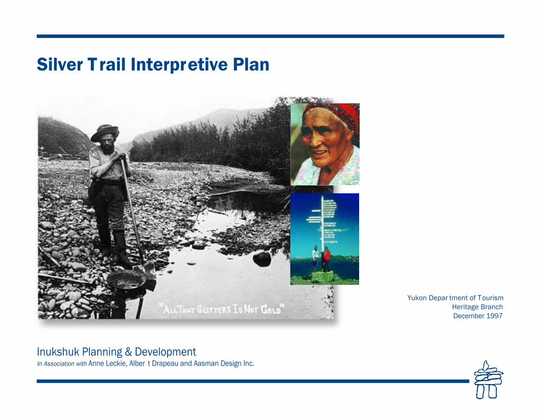
Silver Trail Interpretive Plan 1997
60
Inukshuk Planning & Development In Association with Anne Leckie, Alber t Drapeau and Aasman Design Inc. Silver T rail Interpretive Plan Yukon Depar tment of T ourism Heritage Branch December 1997
Transcript of Silver Trail Interpretive Plan 1997
Inukshuk Planning & DevelopmentIn Association with Anne Leckie, Alber t Drapeau and Aasman Design Inc.
Silver Trail Interpretive Plan
Yukon Depar tment of TourismHeritage Branch December 1997

2Silver Trail Interpretive Plan–December, 1997

3Silver Trail Interpretive Plan–December, 1997
1.0 Introduction ................................................................................................. 31.1 Program Background & Plan Context .................................. 51.2 Purpose & Objectives.................................................................... 61.3 Planning Approach ......................................................................... 6
2.0 The Tourism Context ................................................................................ 7
3.0 The Existing Situation ............................................................................ 93.1 Program Background & Plan Context ................................. 113.2 Duncan Creek Road Corridor Overview ............................ 173.3 Assessment of Current Sign Text.......................................... 20
3.3.1 Stewart Crossing to Mayo ........................................ 203.3.2 Mayo to Keno City ........................................................ 213.3.3 Duncan Creek Road .................................................... 24
3.4 Analysis of Thematic Representation ................................. 253.5 Implications for Interpretive Plan Development .......... 26
4.0 Silver Trail Corridor Interpretation Plan ....................................... 27
4.1 Approach ......................................................................................... 274.2 Thematic Representation Rationale .................................... 304.3 Media and Audience ................................................................... 304.4 Highway Interpretive Units ...................................................... 314.5 Sign Types and Locations ....................................................... 31
4.5.1 Silver Trail Corridor...................................................... 334.5.2 Duncan Creek Road .................................................... 33
5.0 Sign Design Concepts.......................................................................... 36
6.0 Implementation and Operations ...................................................... 39
6.1 Priorities ........................................................................................... 396.2 Directional Signs .......................................................................... 416.3 Capital and Maintenance Costs ............................................ 42
Table of Illustrations
Map of Silver Trail Interpretive Plan Study Area................................ 2Map of Existing Dept. of Tourism Interpretive Signs........................ 10Typical Regional Site ...................................................................... 27Map of Overall Corridor Plan .......................................................... 28Typical Minor and Major Sites......................................................... 29Map of Silver Trail, Stewart Crossing to Mayo................................. 32Map of Silver Trail, Mayo to Keno ................................................... 34Map of Silver Trail, Duncan Creek Road Loop ............................... 35Corridor Identity Image .................................................................. 36Typical Panel Design, Colour Pallet ............................................... 37Panel Frame Cross-Section and Post Details ................................ 38Stewart Crossing–Regional Orientation Exhibit ............................. 39Stewart River Valley Overlook–Major New Site ............................. 40Minto Bridge–Major New Site ......................................................... 41Major and Minor Site Advance Warning Signs ............................... 42
Table of Contents

4Silver Trail Interpretive Plan–December, 1997
Silver Trail Interpretive Plan–December, 19972
Mayo
Minto Lake Road
Mayo
Keno
Elsa
Stewart Crossing
Mayo LakeHalfway
Lake
McQuesten Lake
Janet Lake
Williamson Lake
Ethel Lake
Edwards Lake
Penape Lake
Big Kalzas Lake
Klondike River
Beaver River
North
McQ
uest
enRiv
er
South M
cQ
ueste
nRi
ver
McQ
ueste
n River
Stewart River
Keno Ladue River
Stewart River
Hess River
Stewart River
Mt. Haldane
Keno Hill Summit
Wernecke
Old Indian Village
Dam
Mayo Dam
Mayo LakeRoad
City
WarehamMintoLake
Hungry Mtn.
Fraser Falls
Moose Creek
Wind River Trail
Duncan Cre
ekRo
ad
▲NNNN 5 0 5 10 15 20 25 km
SCALE
S I L V E R T R A I L I N T E R P R E T I V E P L A N
S T U D Y A R E A
Mayo River
Kathleen Lakes
ALASKA
B.C.
YUKONNORTHWEST TERRITORIES

The Silver Trail branches off the Klondike Highwayat Stewart Crossing. It follows the north fork of theStewart River into the heart of the traditional terri-tory of the Nacho Nyak Dun for a distance of 112km At Mayo the road turns north to Elsa, ending atKeno City. The current highway was constructed in1950 to link Whitehorse to Mayo. The originalMayo to Keno City wagon road intersected theLiberal Trail winter road from Mayo to DawsonCity and the Duncan Creek Road just north ofMinto Bridge. These original roads wereconstructed in 1904 with the road to Elsa (GalenaCreek) built by 1915, following the discovery ofsilver. The Stewart River bridge was completed in1960. Numerous exploration roads and trails havebeen constructed off the Silver Trail since. TheWind River Trail, McQuesten, Minto and MayoLake roads are all examples.
Mining interest in the Mayo region began in the late1800s. A minor gold rush took place in 1885 whenthe first placer miners came to work the river barsof the Stewart and McQuesten Rivers. By 1887,$100,000 worth of gold had been extracted from thebars in the Stewart River bed. Miners headed forDuncan Creek, disembarked from the steamboats atGordon, and later, Mayo Landing. The currentMayo town site, named after Frank Mayo, wasestablished in 1903.
Silver mining began in 1906 when H.W.McWhorter discovered silver in Galena Creek,three miles south-west of Elsa. The first silver mine,at Silver King, operated between 1913 and 1918.The entrance shaft is still visible from the road.The nearby United Keno Hill Mines Ltd. continuedto extract ore until the late 1980s. At its peak in the
1950s, United Keno Hill was the largest silverproducer in North America and the fourth largest inthe world.
The communities in the Mayo Mining District haveexperienced the boom and bust cycle common tomining regions throughout the world. A numberof mines have since been abandoned with the Elsatown-site being dismantled following the closure ofthe United Keno Hill operations. The population ofKeno City has also dwindled to around 40 perma-nent residents. With a population of just under 500people, Mayo continues to function as the govern-ment, transportation, service and regional supplycentre for the central Yukon. The area still has
significant mineral potential and active explorationand mining activity continue to this day.
The tourism potential of the Silver Trail was notreally appreciated until the early 1980s. As part ofa bid to encourage more tourism into the region, aregional tourism association was established. Teninterpretive signs were erected by Yukon Tourismalong the Silver Trail corridor in the mid eighties.One of the most noticeable initiatives of the newregional tourism association was to adopt andpromote the “Silver Trail” theme. This resulted inthe visitor information booth development atStewart Crossing and the erection of banner poles atkey locations along the road corridor.
5Silver Trail Interpretive Plan–December, 1997
1.0 Introduction
The “Silver Trail theme” promoted with the use of banners.

The tourism association also started to develop itsown site location identification signage.
The Silver Trail provides the visitor with threedistinct driving images. Between Stewart Crossingand Mayo, the driver is exposed to occasional viewsof the river and Hungry Mountain as the roadfollows the Stewart River valley away from theTintina Trench. The visitor passes through a whitespruce forest in the first 5 kms. which insulates theunderlying permafrost. The swampy marshland inthe valley floor, visible at km 6, reflects past rivermeanders. This narrow winding portion of the roadgradually gives way to an area of sand dunes beforeclimbing onto the McConnell moraine at about km32. The forest cover along this stretch of road ispredominantly aspen, poplar and birch, reflecting the
drier soils and southern slope exposures. There arealso lodgepole pine trees which are near theirnorthern limits. At the end of the McConnell glacia-tion, a lake was formed behind an ice dam whichcrossed the valley at km 54 (Burn 1985). The lakeextended upstream as far as Fraser Falls, leaving fineice rich sediments underlain by permafrost.
The stunted black spruce, extensive wetlands andthermokarst lakes (often called “drunken” forests)between Mayo and Elsa reflect this glacial history.The visitor is afforded a panoramic view of theMayo River valley and Lake Wareham afterclimbing Glacier Hill, aptly named for the icingsthat develop each winter from subsurface springs.Mt. Haldane stands out in the distance. The moun-tain is all the more impressive because it stands
alone, towering over the adjacent ridges. As thetraveller reaches Minto Bridge, the wetlands visibleat the bridge provide excellent migratory water-fowl habitat. The wetlands were created as a resultof the construction of the Wareham dam and earlyplacer mining activity. Approaching Elsa andGalena Hill, evidence of the area’s mining historygradually becomes more visible with good viewsout over the McQuesten River valley. The originalSilver King claim and drift, at km 93, is easilymissed, its significance unmarked.
Approaching Keno City, the peaks of the PattersonRange provide a distant backdrop to the visiblesigns of mining activity around the community.While the road formally ends at Keno City, manyconsider the true end of the road to be the signpost atop Keno Hill summit. From here there arespectacular 360 degree views of the surroundingcountry-side. The twin peaks of Mt. Hinton towerabove Keno Hill.
The Duncan Creek Road winds through the narrowDuncan Creek valley from Keno City back towardsMinto Bridge. Locals describe this road as a drivedown a “country lane”, while others are morecautious, noting the road receives only seasonalmaintenance. There are only brief glimpses of theupper canyon as the creek flows south-west towardsthe Mayo River. The dense vegetation and prolif-eration of alders reflect the extensive disturbance ofthe area in prior years and recent fire history.
Interpretive signs give residents and visitors alike,an appreciation of the Yukon’s natural, cultural andhistorical features. Along the Silver Trail andDuncan Creek Road loop there are numerous addi-tional opportunities to tell a story about the region’snatural, cultural and historic features. These signageopportunities provide a simple, inexpensive way toinform, interest and educate the viewer on a yearround basis.
6Silver Trail Interpretive Plan–December, 1997
Looking east towards Mayo McConnell moraine

The primary objective of a road-side interpretivesign is to tell a story. The story will have manythemes describing how places got their names, whysome landscape features are present and others not,descriptions of people who use the land and histor-ical events that have taken place along this trail.
1.1 Program Background and PlanContext
The Department of Tourism Heritage Branch hasthe primary responsibility for developing and main-taining interpretive signage along the principalhighways within the Yukon. In 1995, theDepartment commissioned a study of all existing
highway interpretive signage with a view to estab-lishing program guidelines. The Yukon InterpretiveSignage Strategy (Inukshuk Planning &Development, 1995) provides Yukon-wide guide-lines for new site selection, spacing distances, siterationalization, sign construction and maintenance.The program guidelines provide direction for thepreparation of these corridor specific plans.
7Silver Trail Interpretive Plan–December, 1997
Mt. Haldane
Key recommendations from the 1995 Strategywhich guide the succeeding corridor plans include:
• program principles such as optimum spacingdistances between sites and facilities; variety ininterpretive media, message balance andrepresentation; the need for year round siteaccessibility; and shared responsibility forprogram implementation;
• a hierarchy of sign types reflecting sitesignificance and role, differentiating betweenterritorial entrance, regional orientation, majorand minor locations;
• program management directions to encourageinter-agency co-operation and co-operativepartnerships in plan implementation;
• site facility development policies regarding theappropriate use of information booths, toilets,garbage containers, viewing platforms andsimilar support infrastructure; and
• inspection and maintenance standards to guideannual inter-agency agreements on sitemaintenance and facilitate budgeting.
In 1996, plans for the Klondike Highway werecompleted. In the Interpretive Plan for the NorthKlondike Highway, general reference is made to theStewart Crossing regional orientation site. TheNorth Klondike report suggests that the StewartCrossing site is not significant in terms of its utilityfor that corridor but recognizes its relevance for aSilver Trail plan.
The Silver Trail is a priority because the existingsignage is all at least 12 years old and many themesare missed or under-represented by the 10 existingsigns. The regional tourism association also believesinterpretive signage can play a valuable role intourism promotion, attracting more visitors intothe heart of the region.
1.2 Purpose & Objectives The intent is to produce an interpretive plan thatdescribes themes, suggests appropriate locationsand presents guidelines for sign placement and siteupgrading along the Silver Trail and Duncan CreekRoad loop. The goal is to present the road trav-eller with an accurate, balanced, and interestingpicture of the Silver Trail landscape, highlightingthe natural, cultural and heritage character of thecorridor.
The study objectives include:
• identifying representative themes and messagesfor both the Silver Trail and Duncan CreekRoad;
• evaluating the effectiveness of existing signagefor site location appropriateness, redundancy,message currency, theme representation andbalance;
• determining the need for new sites forinterpretive site development;
• formulating concepts for corridor motifs andkey site priorities;
• outlining the capital costs and operationalrequirements, recommended corridorimprovements; and
• seeking Nacho Nyak Dun First Nation,community, and government agency input indefining corridor needs, suggesting changes anddevelopment priorities, locating new sites,evaluating message content and creatingcorridor motifs.
1.3 Planning ApproachThe study approach involved a review of the roadcorridor history, 1989 regional tourism plan, 1992Silver Trail Marketing Strategy and the 1994 VisitorExit Survey regional data. This was followed by
interviews with individuals, government agencies,First Nations, area communities and a field-tripalong both roads.
This report highlights the opportunities, thematicdeficiencies and issues which were considered indrafting the corridor signage development plan.The strengths and weaknesses of the existing sitesare discussed in terms of location, theme represen-tation, message content and current utility.Recommendations for possible corridor improve-ments are then put forward.
In their 1992 report Silver Trail Marketing PlanGraham & Associates conclude: “the Silver Trail isa positive concept, but the term is limited in marketappeal.” From a regional tourism planning perspec-tive this might be true; in terms of the corridoritself, it does present a simple, identifiable conceptand readily identifiable visual image.
However, as the authors note in the marketingstudy, the “silver trail” theme is not inclusiveenough to properly represent the range of interpre-tive themes that could, and should, be portrayedalong the corridor. The most obvious missing themeis the First Nation “homeland” connection. This isa major deficiency for three significant reasons.First, it implies that the landscape was largely“unoccupied” prior to European exploration andsettlement. This is simply inaccurate. Second, theNacho Nyak Dun First Nation presence is a story inits own right and visitor research confirms thatFirst Nation history and culture is of significantinterest to the tourist. Third, government is oblig-ated to respect the land claim settlement legislationand support their culture. Making the visitor awarethat they are within the traditional territory of theNacho Nyak Dun is one way that First Nationsinterests can be protected and respected.
8Silver Trail Interpretive Plan–December, 1997
The Silver Trail region is relatively unknown and itsvisitor potential largely undiscovered. The existing1989 Silver Trail Tourism Development Planemphasizes the need to draw visitors off theKlondike highway into the area. Improving theinterpretive signage is viewed as one means to“market” this road as an attractive travel corridor.
The 1994 Visitor Exit Survey (VES), reveals that88% of the travellers on the Klondike Highwaysimply passed by the Silver Trail region withoutstopping. A significant opportunity and difficultchallenge for the region is to secure a larger share ofthis pass through traffic. The 1994 VES indicatesthat 29% of the visitors to the Yukon came to theSilver Trail region at some time during their Yukontrip. However, of the approximately 60,000 visitorswho passed through the region, only 7,290 (12%)actually stopped. This is not surprising since trav-ellers on the Klondike highway have to “go out oftheir way” to explore the Silver Trail corridor. Ofthose who did stop over, 78% had pre-planned theirvisit, while another 14% had not planned to visit theregion, but at some point chose to do so.
Given the short length of the highway corridor(112 km), a side trip excursion for visitors travellingthe Klondike Highway to and from Dawson City is
not a major decision as the diversion can take aslittle as 3 or 4 hours. The key determinant is timeand visitor flexibility. The VES data confirms that98% of Silver Trail regional visitors were on a“pleasure” trip and 94% used a vehicle other thanpublic transportation. Almost 44% used a motor-home, RV, camperised car, truck or van which fitsthe profile of an independent traveller. Sixty-sevenpercent of those who stopped and stayed overnightused existing campgrounds. This also supports theconclusion that most visitors are independent trav-ellers.
A comparison of the road flow pattern between1987 and 1994 suggests there has been a notableincrease in visitation numbers into the heart of theregion. Since road conditions do not appear to havebeen a limiting factor, this suggests that the type ofvisitor who did come knew what to expect andwas not dissatisfied with their experience. The 1994VES data and road flow pattern analysis does notinclude Yukon residents who may regularly visit thearea for recreation. It is also not apparent whethertravellers made a conscious effort to explore theSilver Trail and Duncan Creek Road loop orwhether they merely stopped at Stewart Crossing.
The importance of the Stewart Crossing regionalorientation site cannot be overlooked, for severalreasons. First, the highway junction occurs at a“T” intersection which creates a natural decisionpoint. While the data indicates that 78% of thevisitors had already made a decision to visit theregion before reaching Stewart Crossing, 14%appear to have been encouraged to do so somewhereenroute. In developing the Stewart Crossing site, theSilver Trail Tourism Association set their goal atdiverting 5% of Klondike Highway traffic. It is notpossible to confirm from the available data whatinfluence the Stewart Crossing site really hadbecause no tracking measurement was employed.However, it is reasonable to presume the site hadsome influence. Similarly, Heritage Branch installeda radio transmitter at the same location whichprovides a concise summary of the Silver Trail andencourages visitors to take the side trip. Again,without a tracking mechanism, it is impossible todetermine the effectiveness of this initiative.
The inclusion of Binet House and the Keno CityMining Museum in the government’s “passport”program has resulted in a notable increase in visi-tation to these two facilities. What is more notableis that these are both interpretive facilities whichconfirms public interest in interpretive opportuni-ties. Thus, updating the highway signage programcomplements those tourism attraction initiatives.
The regional interviews also confirm that improvingthe regional orientation display at Stewart Crossingand developing a clear gateway to the Silver Trailregion is a priority issue. The logic behindimproving interpretive signage along the SilverTrail is consistent with the nature of the dominantvisitor market.
9Silver Trail Interpretive Plan–December, 1997
2.0 The Tourism Context
1994 Yukon Visitor Exit Survey Visitor Road Flow Pattern Analysis
1987 VES 1994 VESHighway /Segment (No. of Visitors) (No. of Visitors)
Stewart Crossing to Mayo 0 – 2,000 3,800
Mayo to Stewart Crossing 0 – 2,000 3,800

The traveller characteristics are remarkably similarto those of the Campbell Highway. Significantly,scenery was the main attraction and lack of time theprincipal reason for not staying longer in the region.Fifty-six percent (56%) of those who did come indi-cated that they wished they had allowed more time(VES 1994). This was the most common response inall nine Yukon tourism regions. When visitors wereasked what the single most negative thing abouttheir visit to the Silver Trail region was, twenty-fourpercent (24%) mentioned transportation concernswhile 18% indicated nothing at all.
A closer look at the data though, suggests that only13.5% of these travellers rated the road conditionsas poor. The survey question, however, did notdifferentiate between sections of road. For example,between Stewart Crossing and Mayo, the road ischip-sealed. From Mayo to Keno City the road hasa reasonable gravel base while the condition of theDuncan Creek Road varies significantly withweather conditions.
Very little specific research has been done in theYukon on visitor interest in interpretive signage.The 1992 Psychographic Segmentation Study and adepartmental survey in 1994 provide some generalinformation concerning visitor interest and site usewhich are applicable here. Applicable conclusionsinclude:
• Yukon visitors generally expect to seeinterpretive signs and stop when they do,
especially if they have advance warning;
• reading about a site in the Milepost magazineoften accounted for their stop;
• visitors stop most often to view the scenery,take a rest or read the sign, with preferred sitesbeing those with a significant view;
• visitors like to have and will use basic facilitieswhen provided, such as toilets and garbagecontainers;
• the quality and approach to interpretive signagetaken by the Yukon appears to be meetingvisitor needs;
• the visitor profile is changing with a younger,more mobile segment of the tourist marketlooking at the Yukon as a discrete destinationfrom the traditional primary destination ofAlaska; and
• the independent highway traveller profile mostclosely fits the “Organized NeighbourhoodOutdoor Folk” and “Earthy Explorer”psychographic study categories.
The most significant change between 1987 and1994 is in visitor origin, as illustrated by the Pointof Origin table.
According to the 1994 VES, visitors from BritishColumbia and Alberta make up 62% of allCanadian visitors while Germans dominate theoverseas market (53%), followed by the Swiss(20%). While there has been a slight drop inCanadian and American visitors, it has been offsetby increases in overseas travellers, particularlyfrom German speaking countries.
Silver Trail residents have indicated that numerousenhancement opportunities exist. Tourism Yukon isupdating the Silver Trail Tourism Plan this year, andinterpretive signage improvements will be animportant part of the implementation strategy. Withover 93% of visitors being independent and travel-ling by vehicle, improving the effectiveness ofinterpretive signage along the highway is consistentwith visitor needs and regional tourism develop-ment goals.
Minto Bridge
10Silver Trail Interpretive Plan–December, 1997
Points of Origin
Country 1987 1994Canada 32% 21.8%
United States 55% 50.2%
Overseas 13% 28%
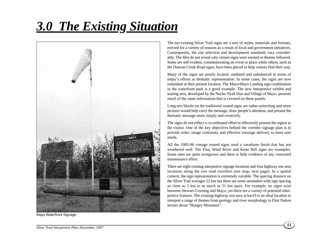
The ten existing Silver Trail signs are a mix of styles, materials and formats,erected for a variety of reasons as a result of local and government initiatives.Consequently, the site selection and development standards vary consider-ably. The files do not reveal why certain signs were erected or themes followed.Some are self-evident, commemorating an event or place while others, such asthe Duncan Creek Road signs, have been placed to help visitors find their way.
Many of the signs are poorly located, outdated and unbalanced in terms oftoday’s efforts at thematic representation. In some cases, the signs are nowredundant at their present location. The Mayo/Mayo Landing sign combinationin the waterfront park is a good example. The new interpretive exhibit andseating area, developed by the Nacho Nyak Dun and Village of Mayo, presentsmuch of the same information that is covered on these panels.
Long text blocks on the traditional routed signs are rather uninviting and morepictures would help carry the message, draw people’s attention, and present thethematic message more simply and creatively.
The signs do not reflect a co-ordinated effort to effectively present the region tothe visitor. One of the key objectives behind the corridor signage plan is toprovide order, image continuity and effective message delivery to meet userneeds.
All the 1985-86 vintage routed signs used a varathane finish that has notweathered well. The Elsa, Wind River and Keno Hill signs are examples.Some sites are quite overgrown and there is little evidence of any concertedmaintenance effort.
There are eight existing interpretive signage locations and four highway rest arealocations along the two road corridors (see map, next page). In a spatialcontext, the sign representation is extremely variable. The spacing distance onthe Silver Trail averages 22 km but there are some anomalies with sign spacingas close as 2 km to as much as 51 km apart. For example, no signs existbetween Stewart Crossing and Mayo, yet there are a variety of potential inter-pretive features. The existing highway rest area at km19 is an ideal location tointerpret a range of themes from geology and river morphology to First Nationstories about “Hungry Mountain”.
11Silver Trail Interpretive Plan–December, 1997
3.0 The Existing Situation
Mayo Waterfront Signage

12Silver Trail Interpretive Plan–December, 1997Silver Trail Interpretive Plan–December, 1997
10
Mayo
Minto Lake Road
Mayo
Keno
Elsa
Stewart Crossing
Mayo Lake
Halfway Lake
McQuesten Lake
Janet Lake
Williamson Lake
Ethel Lake
Edwards Lake
Penape Lake
Klondike River
Beaver River
North
McQ
uest
enRiv
erM
cQue
sten Rive
r
Stewart River
Keno Ladue River
Stewart Riv
er
Stewart
River
Mt. Haldane
Keno Hill Summit
Wernecke
Old Indian Village
Dam
▲NNNN 5 0 5 10 15 20 25 km
SCALE
Mayo Dam
Mayo LakeRoad
City
WarehamMintoLake
Hungry Mtn.
Fraser Falls
Moose Creek
S I L V E R T R A I L I N T E R P R E T I V E P L A N
E X I S T I N G D E P T. O F T O U R I S M I N T E R P R E T I V E S I G N S
Wind River Trail
DUNCAN CREEKROAD #1
DUNCAN CREEKROAD #2
DUNCAN CREEK1
DUNCAN LANDING2
ELSA
REST AREA
REST AREA
REST AREA
REST AREA
WIND RIVERKENO HILLTRAIL
MAYO1
MAYO LANDING2
SILVER TRAILREGIONAL ORIENTATION
STEWARTRIVER
Duncan CreekRoad
Tourism Interpretive Sites
Existing Highway Rest Areas
Mayo R iver
Kathleen Lakes
ALASKA
B.C.
YUKONNORTHWEST TERRITORIES
Most of the existing signs are located at key roadjunctions with the exception of the two Mayo signs,and the Keno Hill sign. The eight existing locationsare: Stewart Crossing (km 0), the Mayo/MayoLanding signs on the Mayo waterfront (km 51), theidentical Duncan Creek Road/Silver Trail junctionsigns (km 69 Silver Trail, km 0 Duncan Creek Roadat Keno City), Elsa (km 100), the turnoff to WindRiver Trail (km 102) and one in Keno City (km 111).
There are also two signs on the Duncan CreekRoad at the turn-off to Mayo Lake (km 21.5Duncan Creek Road). Except for the more recentStewart Crossing interpretive signage, all the signswere erected in 1985 and 1986 and are nearing theend of their useful life.
Overall, the current Silver Trail interpretiveprogram covers four of the broad thematic cate-gories identified in the Yukon Interpretive SignageStrategy (Historic – Settlement; Historic –Exploration and Mining; Historic – Transportationand Communi-cation; Regional Orientation).However, half of the current interpretive signs areactually Historic – Exploration and Mining, withsilver mining being the dominant theme.Furthermore, all ten interpretive signs refer to Euro-american history themes with no mention of FirstNations history. A better balance is also neededbetween natural, cultural and historic themes tokeep visitor interest up and properly represent theregion as a whole.
3.1 Silver Trail Site Assessment
Stewart River (km 555.5 N. Klondike Hwy)This site lies north of Stewart Crossing and is partof the Klondike Highway. In the North KlondikePlan, this site is to be relocated approximately 1 kmto the north and developed as a major site. Both theproposed First Nation and ecology stories couldintroduce a Silver Trail regional element.
A problem with having the regional orientation siteto the south, at Stewart Crossing is that it is locatedafter the highway intersection and requires south-bound travellers to back-track across the bridge, ifthey decide to take the Silver Trail. It is possible thatan additional orientation sign could be incorporatedinto the Stewart River site, promoting the Silver Trailregion to the visitor. Such a sign could be developedwith the regional tourism association through a co-operative partnership. The sign could be funded andmaintained by the regional association.
Stewart Crossing (km 537 N. KlondikeHighway; km 0 Silver Trail)Stewart Crossing is recognized as the “gateway” tothe Silver Trail. The Klondike Highway and thestart of the Silver Trail form a T-intersection atStewart Crossing, creating a natural decision pointfor the tourist. Originally, Stewart Crossing was asawmill and wood camp for the steamboats andthis community history has not been interpreted todate. The existing rest area was originally used as acommunity postal kiosk. The site was expandedto include picnic tables, garbage cans and toiletswith the visitor information booth added later by theSilver Trail Chamber of Commerce and TourismAssociation (STTA).
The existing site has several limitations. It is locatedon the south side of the Stewart River bridge, pastthe highway 11 junction for southbound traffic.
13Silver Trail Interpretive Plan–December, 1997
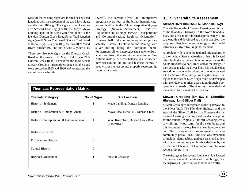
Thematic Representation Matrix
Thematic Category No. of Signs Site Location
Historic - Settlement 1 Mayo Landing, Duncan Landing
Historic - Exploration & Mining; General 4 Mayo, Elsa, Keno Hill, Duncan Creek
Historic - Transportation & Communication 4 Wind River Trail, Duncan Creek Road(2 identical)
Historic - General 0
First Nations History 0
Natural History 0
Regional Orientation 1 Stewart Crossing

Also there are few visual signs from the northsuggesting the regional orientation function of thissite.
For northbound traffic the site is located on theopposite side of the natural traffic flow.
The site is cluttered and not well maintained. Thesite contains post office boxes, a visitor radio frequency sign, a small visitor information booth,outhouses and three interpretive panels in a woodenframe. Site maintenance has been a recurring issuebecause of the number of uses.
One proposal is to move the visitor informationbooth to private property across the road and leavethe outhouses and signage where they are.
Establishment of a second site would be confusingto travellers, but would make more area availablefor interpretive site development.
A second proposal would be to explore the feasi-bility of relocating the entire site across the road.This would entail entering into joint venture discus-sions covering site development and maintenance.
In either case the existing signage is not adequatefor a regional orientation site.
The existing booth sign was installed in 1991. Themessage deals with the character and points ofinterest of the Silver Trail, focusing primarily on thereadily accessible wilderness and hiking trails nearKeno City and the general Silver Trail mining
history. This may entice some travellers but doesnot fully embellish the attractions of the area. Forexample, there is nothing to entice the visitor todrive even the first 10 km into the Devil’s Elbowwetland area. There is also an opportunity to inter-pret the history of the road and make some refer-ence to Mayo. First Nations culture and naturalhistory themes are noted but could be expanded.
The interpretive sign structure needs to be modifiedsince its effectiveness is limited by the angle of thesign enclosure and the lack of direct access to thesignage by the support beams across the front(see picture below).
14Silver Trail Interpretive Plan–December, 1997
Silver Trail Intersection Stewart Crossing Interpretive Kiosk

In the past, some have considered the toilet facilitiesto be an unnecessary operational cost, given thelocation of visitor service facilities at the lodge(currently closed). However, the existing toiletfacilities appear to be over-used, confirming theirvalue. The outhouses should either be repaired orreplaced and a screening wall separating theouthouses from the rest of the site added.Alternatively, public washrooms could be inte-grated with a new Stewart Lodge building.
It will be important to work with the site owner tointegrate the future interpretive site with the rede-velopment plans for Stewart Lodge. The existingpost office mail boxes and “no camping” sign arealso out of context with the surroundings and wouldbe best relocated.
Since Stewart Crossing is a highly visible site withconsiderable local interest and involvement, theregional orientation focus is appropriate. It is alsoimportant that the graphic signage of the site beassociated with the start of the Silver Trail and notthe Klondike Highway, so that visitors see theSilver Trail as another opportunity, entirely separatefrom the highway corridor they have beenfollowing.
Devil’s Elbow (km 9.6)In the initial stretch of road there are limited andoccasional views of the river and the associatedwetlands created by former meander channels. Thissection of the Silver Trail provides some excellentopportunities for wildlife viewing, and moose andwaterfowl can often be seen along the StewartRiver. A moose calving protected site existsbetween km 6-16 and a moose calving sign is
located at km 3.7. The sign, however, is too smallfor most highway travellers to read. The NachoNyak Dun identified the interpretive potential of theDevil’s Elbow site.
A shallow pull-out already exists along the bluff,overlooking the river at Devil’s Elbow. The bank istoo steep and the road too narrow to create a safeand cost-effective rest area at this location. Otherproblems with this site include a rather restrictedview and poor sight lines from the east.
The Mayo District Renewable Resources Councilhas also expressed interest in seeing this site devel-oped. A safer alternative site exists in the vicinity ofkm 10.2 where an abandoned gravel pit could beused as a parking area and short trails might bedeveloped in partnership with the Mayo DistrictRenewable Resources Council. The spacingdistance is appropriate for a minor rest area. Exactsite location would require further consultation.
Stewart River Valley Overlook (km 19)The first existing highway rest area is a pull-out atkm 19, overlooking the Stewart River Valley. Nointerpretive signage exists but this would be anexcellent opportunity to develop a major interpre-tive site at minimal cost. Possible themes includegeology, river morphology, and a First Nationsstory about Hungry Mountain.
The site has one garbage can. Toilets would need tobe added and brush cleared to open up the view.
The Conservative Trail (km 38.8)The road continues to climb onto the McConnellmoraine and outwash plain. The Conservative Trail,a back road to mining properties, joins the Silver
Trail at km 38.8, goes behind Liberal Ridge andeventually joins up to the Minto Lake Road. This isnot always vehicular accessible but is a good hikingor biking area, offering a trailhead opportunity.This creates a loop recreation trail possibility thatcould also be acknowledged at the Minto Lakesite.1 The transportation interpretive theme can bebetter interpreted elsewhere.
Highway Rest Area (km 44)At km 44, there is another Highways rest area withthree tables and two outhouses. This location has noobvious interpretation potential and given its prox-imity to Mayo, the addition of interpretive signageis not recommended.
McIntyre Park (km 49)As the road continues to Mayo, it descends a steepembankment down to the Mayo River.
Just before the Mayo River bridge lies McIntyrePark, a small picnic site and day-use area managedby the Village of Mayo. Others have suggesteddeveloping this site because of the salmonspawning and old fish trap that was once used here.
As this site is on the village boundary and less than1 km from the Mayo-Keno City intersection, itwould be a suitable location for the local commu-nity to develop as part of the regional tourism plan.
A pull-off has been constructed just after the MayoRiver bridge, less than 250 metres from the entranceto McIntyre Park. A large village identification signand a map of Mayo streets were installed here in1992 by the Silver Trail Chamber of Commerce andTourism Association. The location is not ideal norvery visually appealing.
15Silver Trail Interpretive Plan–December, 1997
1 Recreation trail development is not within the Heritage Branch sign program mandate. The interpretive opportunity is just being recognized. Development is dependent on First Nation and government consultation.

Village of Mayo/Mayo Landing (km 51)The Silver Trail turns north at the Village of Mayo(km 51). Two interpretive signs have been erectedtogether in the waterfront park adjacent to theStewart River. These routed cedar signs, installed in1985, cover the history of Mayo Landing and thesigns are in poor condition. A new interpretive siteis currently being developed at the foot of CentreStreet and eliminates the need for this signage. The
site is also within one block of Binet House.
The signs should not be replaced at this location andthe site should be dropped from the HeritageBranch inventory.
Beyond Mayo, the Silver Trail leaves the StewartRiver and heads north, following the Mayo Rivervalley towards Elsa. While the community ceme-tery at the airport contains some interesting grave
sites of area pioneers, it does not really fit into thisprogram. The Frog Lake Wetlands Protected Arealies behind the airport but there does not appear tobe a suitable site next to the road for an interpretivesite.
Wareham Lake Hydro Dam (km 56)At km 56, there is a small road junction on the leftleading to the Wareham Lake Hydro Dam. A sideroad off this road links up with the access to the territorial campground. Only a short drive fromthe highway, the dam offers a scenic viewpoint.Yukon Energy has recently fabricated their owninterpretive sign at the highway so no additionaldevelopment is needed.
Five Mile Lake Campground (km 56.5)Beyond the Wareham Lake Hydro Dam lie the FiveMile Lake Campground and separate Day UseArea. The recreation potential of this area has beendeveloped by the Parks & Outdoor RecreationBranch in association with the Silver Trail Chamberof Commerce and Tourism Association. Additionalsignage development is not needed.
Glacier Hill (km 59.5)About 8 km out of Mayo the road takes a sharpbend and climbs up Glacier Hill where there is aspectacular view over the Mayo River Valley, withWareham Lake in the foreground. From the top ofthe hill one can also see Mount Haldane in thedistance. This location, at the top of the hill, wouldbe a possible location for a minor interpretive site.Geomorphology, Wareham Lake creation andglaciation themes could be pursued.
Minto Bridge (km 64)A little further on, Minto Bridge (km 64) and thesurrounding marshland offer considerable potentialfor interpretation.
16Silver Trail Interpretive Plan–December, 1997
Village of Mayo Entrance Rest Area

Minto Bridge was the site of a roadhouse for thehorse-teams hauling ore to Mayo at the turn of thecentury. Some old cabin sites can still be seen onhigher ground slightly upstream to the north and theold road is still visible to the west of the bridge. Theexisting marsh was created by construction of theWareham Lake dam and early placer miningactivity to the west. This is a highly productivewetland and excellent migratory waterfowl viewingsite.
Any new interpretive site should be located on thenorth side of the Minto Bridge, away from theprivately owned Mease farm. One can still see theold cabin on their property. Possible interpretivethemes include wildlife viewing, recreation andthe habitat change caused by the placer mining anddam activity.
When this site is developed, it is recommendedthat the Duncan Creek turn-off site be abandonedand the sub-regional orientation sign relocated tothis site.
Mayo Lake/ Duncan Creek Turnoff (km 69)The existing interpretive site at the Duncan Creekturn-off was installed in 1986 and is a logical loca-tion for some form of sub-regional orientation to theDuncan Creek Road loop. This sign was specifi-cally erected to encourage tourism and promoteuse of the “back” road to Keno City. The road isalso used by local residents as the main access toMayo Lake.
The rest area is not properly defined and is reallylittle more than a widening of the intersection itself.The sign can be easily missed by north-boundtraffic. More site definition is required to encouragetravellers to stop. No advance warning signs areprovided. There is one garbage container but noouthouses. It is noteworthy that apart from the
campground and day-use area at km 56.5, thereare no toilet facilities anywhere along the corridorbetween Mayo and Keno City.
Heritage Branch and Highways should worktogether to better define the entry/exit point. Asthe intersection is only three kms north of MintoBridge it may be possible to eliminate this siteentirely if highway directional signage is improved.
The current sign duplicates the sign at Keno City.The interpretive themes portrayed include explo-ration, placer gold mining and transportation historyin the context of sub-regional orientation.
The existing sign has been damaged and is in needof replacement. It displays a regional orientationmap to Mayo Lake but does not show Minto LakeRoad which should be included.
The Duncan Creek turn-off is less than 1 km northof the Minto Lake Road which heads west towardsMinto Lake, Highet Creek, the Liberal andConservative trails. Minto Lake is reputedly a goodarea for moose hunting, however, it is probablynot a good idea to encourage tourists to use thisroad beyond the Minto Lake cutoff due to variableroad conditions. Also, the Highet Creek/Minto LakeRoad is actively used by placer miners and theplacer leasees have expressed some concern aboutliability. The proximity of these two roads and theirrelationship to Minto Bridge is another reason forconsidering concentrating the regional interpretationopportunities at the Minto Bridge site.
Halfway Lakes (km 76)Just before Halfway Lakes is the turn-off for theMount Haldane trail. The intersection is markedby a small routed wood sign erected by the regionaltourism association. The trailhead is 3.5 km to thewest. For the highway traveller there are better
locations to view Mount Haldane so no additionalsignage is proposed for here.
The Silver Trail swings round the north end ofthese lakes past the lodge. Boating and northernpike fishing are popular here. No interpretive signage development is recommended.
Thermokarst Lakes, Mount Haldane View(km 80)In the valley, to the west of the highway, lie acluster of thermokarst lakes which are easily visiblefrom an existing small highway rest area. This is agood example of a typical “drunken forest” causedby permafrost terrain, with trees tilted at differentangles. Mount Haldane also stands out above thethermokarst lakes and is the dominant scenic feature along this section of the highway. Althoughonly 1,839 m high, it is one of the area’s moreimpressive summits, as it stands alone, away fromany ridges. Promotion material on the mountainhas recently been published to encourage tourists tohike up to its summit.
A pull-out and a small sign for Mount Haldanealready exist at km 80. The history of MountHaldane and the thermokarst lakes are logical topics for interpretation at this site.
Corkery Creek (km 83.5)
Another potential interpretive site identified by theParks & Outdoor Recreation Branch is at CorkeryCreek. Here, a trail on the east side of the roadleads up to a tiny waterfall, about 9 metres off theside of the road. An equipment pull-off currentlyexists nearby on the left side of the road. The water-fall is not readily visible from the road because ofthe deep underbrush. While interesting, the fallsare not significant enough to justify site develop-ment.
17Silver Trail Interpretive Plan–December, 1997

South McQuesten River Junction (km 87)The South McQuesten River junction at km 87 is awell used mining road that terminates at DublinGulch. It also provides access to a popular canoeroute. The desire for additional signage has beenexpressed in interviews concerning the newregional tourism plan currently being prepared.Adding additional signage at this location duplicatesthe Wind River sign theme and is not significantenough to compromise the spacing distance stan-dards. Therefore, no sign is recommended here.
Original Silver King Mine (km 93)This section of the road provides one of the betterviews of Elsa and the hillside where silver mininghas occurred. As the road crosses Galena Creek, theruins of the first Silver King mine can be seen on the
south side of the road. Old mining shafts are visiblefrom the road, and a gravel pit just beyond the siteis a possible rest area. Another potential pull-out sitelies on the existing United Keno Hill mine lease.Here, a trail overlooking the mine entrance in thesteep sided ravine could be safely developed.
This is a site where overlooking the spacing criteriacan be justified. Although it is quite close to the signat Elsa and the proposed thermokarst lakes site, it isthe reason behind the “Silver Trail” name. Whilethe mine shaft is visible from the road above thecreek, the road is quite narrow with steep banks,making stopping a safety concern.
Development of this site would require companycooperation and thus better fits into the regionalTourism plan.
Elsa (km 100)A look-out and rest area has existed across from theElsa school for over 40 years. The existing rest areaand sign is in a state of disrepair. The communityalso erected a brass cairn at this site which needs tobe cleaned and restored as part of the site refurbish-ment. The traffic bollards and garbage cans need tobe replaced and there are no toilet facilities provided.Again, the advance warning signage is missing.
The site offers panoramic views of the McQuestenRiver valley with Steamboat Mountain in the fardistance. Various abandoned mines are visible aswell as the tailing ponds created out of the CrystalLake wetlands.
18Silver Trail Interpretive Plan–December, 1997
Local Identification Signage Elsa Rest Area

Wind River Trail (km 102)There is also an interpretive sign just two kmsbeyond Elsa, located at the Wind River Trail roadjunction. The Wind River Trail originated as awinter road, built in the 1950s for truck haulage ofoil-well-drilling equipment and supplies up to mineand oil and gas exploration sites in the RichardsonMountains and Eagle Plains area.
The existing interpretive sign was installed in 1986and gives a general summary of the history of thetrail. Here is an opportunity to add some FirstNations history and explain how the river wasnamed by the Gwich’in because of the furiouswinds which blow down it.
The interpretive site is in a rather dangerous loca-tion with no safe pull-off or advance warningsignage As it is on the west side of the road on theinside of a bend, north-bound travellers easily missit. The sign is also badly weathered.
Keno Hill (km 111)The existing interpretive sign is located at the footof Keno Hill in the centre of the community acrossfrom the restored museum. The rationale for thepresent site is difficult to discern. It was erected in1985. There is no site definition or associated infra-structure. The sign is visible but doesn’t stand out.A more pedestrian oriented exhibit would be appro-priate and in context with the surrounding area.The need for this sign can be questioned as thecontent is covered in the refurbished museum.
Like all the signs built around 1985, the sign isbadly weathered.
Keno Hill Summit (km 113)From mid-June onwards it is usually possible todrive to the signpost at the top of Keno Hill. Fromthe summit one has a spectacular view of the valley,mines and mountain ranges. It is also one of the best
sites to see marmots. The story behind the cairn andsignpost could be told here or at the foot of thehill by re-orienting the content of the existing KenoHill sign.
3.2 Duncan Creek Road CorridorOverview
The 54 km Duncan Creek Road was the originalroad used to haul silver ore from Keno to Mayo.Duncan Creek runs in a south-westerly directiontowards the Mayo River.
Duncan Creek Road (km 0 Duncan CreekRoad)The Duncan Creek Road intersection does not standout from any of the adjoining roads in the commu-nity. The intersection is poorly defined with theinterpretive sign not visible until the secondintersection point about 100 metres down the roaditself.
The road has no edge definition and looks likewhat it is – a relatively little used back road ratherthan an inviting country lane.
19Silver Trail Interpretive Plan–December, 1997
Duncan Creek Road/Silver Trail Intersection

The existing sign duplicates the sign at the SilverTrail cut-off at km 69 of the Silver Trail. The signneeds to be relocated closer to the actual start of theroad rather than at the second intersection where itis not readily visible.
Given the informal road network, it will be difficultto define a suitable orientation exhibit site. Theintersection itself needs to be properly defined andreadily apparent to the motorist. The sign is difficultto read and is more suitable for a pedestrian oriented display. Site development here shouldcreate an entry/arrival gateway image and needs tobe developed carefully to avoid mixing up signfunctions.
The existing silk-screened signboard, installed in1986, is located beside Upper Duncan Creek at theside road to the local ball field. The sign itself is in
relatively good condition, while the frame andcover need repair. There are no advance warningsigns or infrastructure. While it would make senseto have an advance warning sign for north-boundtravellers coming into Keno City, such signagewould not make sense in town for visitors headedthe other way. While a proper pull-out is required,toilet facilities are an added expense that cannot bejustified when the site is within the community.
With better definition of the road entrance andimprovements to directional signage, this site caneventually be eliminated.
Van Cleeve’s Roadhouse (km 19)
Driving along Duncan Creek Road one can some-times see the remains of old mines, fences, logbuildings, cabins and workshops that have been
abandoned since the turn of the century.Unfortunately, most of the log cabins are at bestfoundations or pieces of fences. Van Cleeve’s (aprospector and trapper) roadhouse, the first night’sstop on the journey from Keno to Mayo, used to bean interesting sight to stop at but was mostly wipedout in a forest fire a few years ago. The site ispresently marked by a small sign erected by theregional tourism association.
Duncan Creek Golddusters (km 20.5)Duncan Creek Golddusters is an active family runplacer mine open to tourists. The operation is notvisible from the Duncan Creek Road.
Mayo Lake Fork (km 21.5) The road to Mayo Lake follows the Mayo Rivervalley eastward, across Duncan Creek and along thenorth bank of the Mayo River. The intersection isnot well defined. The main traffic flow is towardsMayo Lake when travelling north-bound. Visually,it is a large intersection with no defined stopping orparking area like the Silver Trail/Duncan CreekRoad intersection. In this case the signs are locatedalong the north axis of the triangle formed by theroad junction.
There are two interpretive signs at this intersec-tion. The placement of the signs is slightly off-centre which encourages north-bound traffic tokeep right rather than continuing northward. Thesigns are not visible to south-bound traffic on theDuncan Creek Road so tourists can easily carry onby without seeing them. There are also no advancewarning signs or proper highway directional signs.
The first sign discusses the history of Duncan Creekwhile the second refers to the location of DuncanLanding and how to reach the abandoned settle-ment. These two routed wood signs are in rela-tively good shape.
20Silver Trail Interpretive Plan–December, 1997
Van Cleeve’s Roadhouse – Local Identification Marker
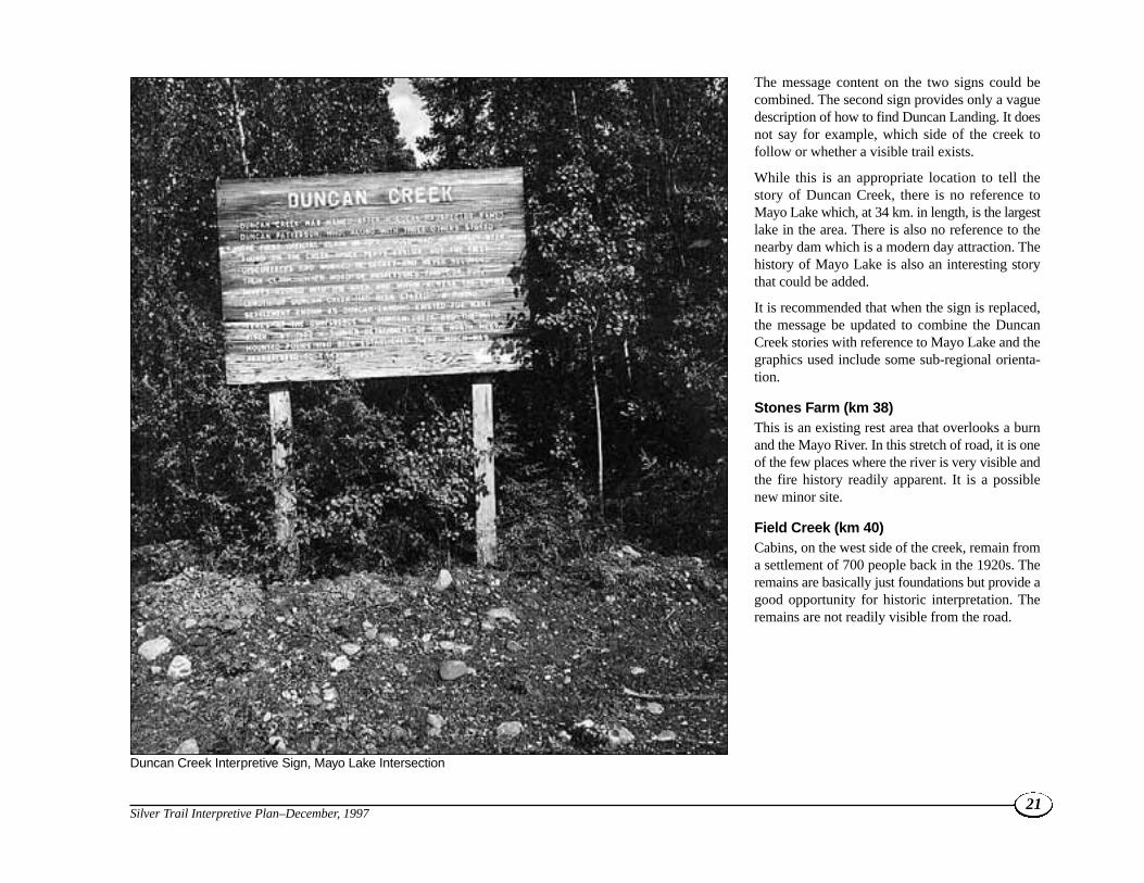
The message content on the two signs could becombined. The second sign provides only a vaguedescription of how to find Duncan Landing. It doesnot say for example, which side of the creek tofollow or whether a visible trail exists.
While this is an appropriate location to tell thestory of Duncan Creek, there is no reference toMayo Lake which, at 34 km. in length, is the largestlake in the area. There is also no reference to thenearby dam which is a modern day attraction. Thehistory of Mayo Lake is also an interesting storythat could be added.
It is recommended that when the sign is replaced,the message be updated to combine the DuncanCreek stories with reference to Mayo Lake and thegraphics used include some sub-regional orienta-tion.
Stones Farm (km 38)This is an existing rest area that overlooks a burnand the Mayo River. In this stretch of road, it is oneof the few places where the river is very visible andthe fire history readily apparent. It is a possiblenew minor site.
Field Creek (km 40)Cabins, on the west side of the creek, remain froma settlement of 700 people back in the 1920s. Theremains are basically just foundations but provide agood opportunity for historic interpretation. Theremains are not readily visible from the road.
21Silver Trail Interpretive Plan–December, 1997
Duncan Creek Interpretive Sign, Mayo Lake Intersection

3.3 Assessment of Current Sign TextTo provide thematic continuity, the messagepresented at each individual sign location wasanalyzed as the messages reflect particular perspec-tives and themes.
The actual text on each Tourism Department sign is
in the left column. The right column contains notesthat explain the text deficiencies and suggestedways to improve thematic representation to makethe signage more relevant today.
Similar to the South Canol Road and CampbellHighway, there is an over-reliance on large panels
with upper case text and no graphic elements.
Upper case text hinders reader comprehension.
Research shows upper case text takes longer, and is
more difficult to read. Adding a graphic element
usually reduces text length and makes the inter-
pretive message clearer.
22Silver Trail Interpretive Plan–December, 1997
EXISTING SIGN TEXT
3.3.1 Stewart Crossing to Mayo
Stewart Crossing
Current Theme: Silver Trail Regional Orientation
Stewart Crossing - km 537 Klondike Highway and km 0 Silver Trail junction
If there is one thing that typifies the Silver Trail area, it is accessibility. Nowhere else can thetraveller find such easy access to a mountain top experience or to the human history of anarea.
Much like the wilderness itself, Silver Trail history, predates the Klondike Gold Rush, isuntamed and still highly visible. Artifacts, buildings, equipment and monuments still dot thelandscape. While efforts are being made to catalogue it, Silver Trail history is not yetconfined to books and memories. Supplemented by tours of the historic Binet House in Mayo and Mining Museum in Keno, travellers here will acquire a first-hand sense of thathistory.
Equally accessible are the area’s recreation facilities and wilderness hikes. Travellers mayreadily drive to alpine meadows and hike panoramic ridge tops by Keno, travel magnificenthistoric waterways by canoe, explore old mine sites for unusual specimens, or fish the area’swaters.
The Silver Trail is a quiet, lightly developed region that will appeal to those who travel witha sense of adventure.
COMMENT
• The existing interpretive signage in the SilverTrail booth was installed in 1991.
• Message deals with the character and points ofinterest of what is essentially a “tributarycorridor”
• Sign encourages people to drive up the SilverTrail. It provides some encouraging glimpsesinto the nature of the trip (focuses on the readilyaccessible wilderness and hiking trails up inKeno City and the general Silver Trail mininghistory). It sounds interesting but is only part ofthe entire story. For example, there is nothing toentice the visitor to drive even the first 10 kminto the Devil’s Elbow wetland area. While notlisted in the sign inventory, two parallel signs atthis booth introduce travellers to the Nacho NyakDun, communities along the trail, early gold andlater silver mining history and wilderness adven-ture opportunities. First Nations culture andnatural history themes should be expanded.
• There is an opportunity to interpret (more) thehistory of the road.
• Modifications to the interpretive sign structureare also highly recommended since itseffectiveness is limited by the angle of the signenclosure and the support beams across thefront tend to keep visitors from approaching thesign and being able to read the information.
• No reference to travel time for visit.

23Silver Trail Interpretive Plan–December, 1997
Village of Mayo
Current theme: Silver mining and trade routes
Village of Mayo - km 51 Silver Trail - on bank of Stewart River
The town site of Mayo was established in 1903, here at the head of navigation on the StewartRiver. It was named after Alfred Harry Mayo, a circus acrobat turned fur-trader who builtseveral posts in the Yukon. The site was a natural boat landing, and Mayo developed intothe distribution centre for the region’s rich mineral resources. Gold had been mined in thearea since 1883, and the discovery of massive silver deposits thirty years later opened upa booming new industry.
Mayo LandingTheme: Historic: Exploration/Mining
Located in the village of Mayo, on the bank of the Stewart River.
The high grade silver ore from Keno Hill was shipped 2,000 miles to smelters from this point.During winter months, 5,000 to 8,000 tons of sacked ore would await the opening of rivernavigation. River traffic stopped in 1950 when roads were built from Whitehorse. The longhaul of silver-lead ore still goes on today, by truck, rail, and ocean liner.
3.3.2 Mayo to Keno City
Duncan Creek Road
Current theme: Mining, trade routes, transportation
km 69 Silver Trail, km 0 Duncan Creek Road*
This entire area was known for years as the Duncan Creek Mining District, taking itsname from one of the first creeks in the area to be prospected. Duncan Creek was namedafter Duncan Patterson, who staked the first claim on the creek in 1901. For many years thiswas the most productive mining district in the Yukon.
The road along Duncan Creek was first built by the territorial government in 1903 and 1904.The original wagon road was constructed in several stages and crossed the creek more thanonce. In many cases ‘roads’ such as this were little more than trails, sometimes built by minersthemselves so that they could haul in supplies and equipment.
• The colour combinations are inconsistent withone sign displaying dark letters on a lightbackground, and the other, light letters on adark background.
• A new interpretive site is currently beingdeveloped for downtown Mayo and thiseliminates the need for signage here.
• Text is outdated.
• No mention of the Old Village of Mayo(relocated) or First Nations.
• Theme adequately covered.
• The long blocks of text are rather uninviting andmore pictures would help carry the message,draw people’s attention
• Map doesn’t show Minto Lake Road
• While there is too much text the themes areadequately covered.
* The same sign is found at km 69 of the SilverTrail (at its junction with the Duncan CreekRoad) and at km 0 of the Duncan Creek Road(at its junction with Keno City).

24Silver Trail Interpretive Plan–December, 1997
Although the rivers provided the main means of travel in the Yukon, wagon roads connectedmajor communities with the small outlying mining camps and kept the district alive.
In the days of horse-drawn transportation, journeys took days instead of hours. Passengerstravelled in large coaches that stopped periodically at roadhouses such as Van Cleave’s forshelter and food.
By 1904 there was a winter road connecting the district with Dawson City. Called theLIberal Trail, after the political party then in power in Ottawa, it wound through the gold miningcreeks of the Klondike District and ended at Minto Bridge, just south of here.This assuredthe importance of Minto Bridge during the winter months, while the town of Mayo, on theStewart River, ranked first during the season of river travel.
With the advent of silver mining in the 1920s the miners had to develop new methods oftransportation to handle the heavy loads of ore. During the summer months the ore wouldbe brought down from the mines in huge horse-drawn wagons. In the winter the wheels wouldbe replaced by runners, converting the wagons into sleighs. The ore was taken to Mayo,where it would be loaded onto sternwheel riverboats for shipment to Dawson or Whitehorse.In the winter months the sacks of ore were stockpiled along the water’s edge, waiting for theice to leave the river. In one boom year there were 22,000 tons of silver ore on the Mayowaterfront.
The road from Mayo to Keno was originally built in the 1930s. First constructed as far as Elsaand later extended to Keno, its completion was one factor in reducing the high costs oftransportation. The horse-drawn wagons were eventually replaced by Caterpillar tractors,which were replaced in turn by trucks. After the highway was completed the loads of orebypassed Mayo and were shipped directly to Whitehorse.
While the Duncan Creek Road is not a major highway, it still can be driven quite easily duringthe summer months. As well as providing a scenic drive of great interest, the route will givea glimpse into the Yukon’s colourful past.

25Silver Trail Interpretive Plan–December, 1997
Elsa
Current theme: Mining
km 100 Silver Trail
In 1924, Prospector Charlie Brefalt staked a silver claim here on Galena Hill and named it afterhis sister, Elsa. It proved to be a major discovery and eventually produced millions of ouncesof silver. Other properties in the area such as the Silver King and Calumet also developed intomajor mines. By the 1930s the town of Elsa had taken shape and it gradually became the majorcommunity serving the mines. Since 1948, Elsa has been home to united Keno Hill Mines whichat one time was the world’s fourth largest producer of Silver concentrates.
Wind River Trail
Current theme: Transportation
km 102 Silver Trail
In the winter of 1959 a 380-mile trail was constructed through the wilderness, leading Northfrom the Keno Road along the Wind and Eagle Rivers to an exploration camp located 45miles past the Arctic Circle. Construction took place in the winter months, when snow andice could form a firm surface for trucks to drive on. This pioneering winter trail concept wasdevised for short-term access to a remote area beyond the existing road system, and itprovided a cheaper alternative to the conventional method of hauling with caterpillartractors. The trail was completed in just three months and by March 1960 over 6,000,000pounds of equipment had been hauled in to the site.
Keno Hill
Current theme: Mining
km 111 Silver Trail
Prospectors have travelled through this district in search of Gold since the 1880s.The firstmajor evidence of silver was discovered in 1919, when Louis Beauvette staked the rouletteclaim on Sheep Mountain, later renamed Keno Hill. In the next few years hundreds of silverclaims were staked, with optimistic names like Lucky Queens and Shamrock.The town calledKeno, named after a popular gambling game, developed here in the 1920s as a supply centreand transfer point. Before the advent of trucks and tractors, sacks of silver ore were hauledby horses down the mountain and transferred here to huge horse-drawn sleighs for the 40-mile journey to the steamboat landing at Mayo.
• To some degree, the old, weathered appearancepresents the right image to visitors as they visitthe ruins of abandoned mines near Elsa and thecommunity of Keno.
• Outdated since Elsa has gone through changessince 1985.
• Varathane finish is peeling.
• No mention of First Nations origin of name“Wind River.”
• Expand message to cover Sign Post Road andarea trails.
• Content is covered elsewhere in museum.
• Sign does not seem to correspond– locationdoesn’t relate to hill.

26Silver Trail Interpretive Plan–December, 1997
3.3.3 Duncan Creek Road
Mayo Lake Junction
Current theme: Mining, orientation
km 21.5 Duncan Creek Road, km 0 Mayo Lake Road junction
Duncan Creek was named after a local prospector named Duncan Patterson, who, alongwith three others staked the first official claim in 1901. Gold had originally been found on thecreek three years earlier, but the first discoverers had worked in secret and never recordedtheir claim. When word of Patterson’s find got out, miners rushed to the area and within ayear the entire length of Duncan Creek had been staked. A mining settlement known asDuncan Landing existed for many years at the confluence of Duncan Creek and the MayoRiver. By 1902 a summer detachment of the North West Mounted Police had beenestablished there, which was transferred to Mayo in 1904.
The site of Duncan Landing can be reached by driving south along the Mayo Lake Road tothe bridge and walking 1/4 mile, following the creek downstream.
• Two signs side by side could have beencombined.
• Site needs orientation signage.
• Missing Mayo Lake boating opportunities.
• Directions vague as far as where to go – no ideawhich side of stream to follow to get to DuncanLanding.
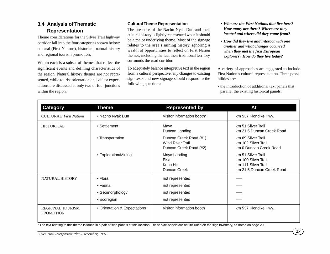
3.4 Analysis of ThematicRepresentation
Theme considerations for the Silver Trail highwaycorridor fall into the four categories shown below:cultural (First Nations), historical, natural historyand regional tourism promotion.
Within each is a subset of themes that reflect thesignificant events and defining characteristics ofthe region. Natural history themes are not repre-sented, while tourist orientation and visitor expec-tations are discussed at only two of four junctionswithin the region.
Cultural Theme RepresentationThe presence of the Nacho Nyak Dun and theircultural history is lightly represented when it shouldbe a major underlying theme. Most of the signagerelates to the area’s mining history, ignoring awealth of opportunities to reflect on First Nationthemes, including the fact their traditional territorysurrounds the road corridor.
To adequately balance interpretive text in the regionfrom a cultural perspective, any changes to existingsign texts and new signage should respond to thefollowing questions:
• Who are the First Nations that live here?How many are there? Where are theylocated and where did they come from?
• How did they live and interact with oneanother and what changes occurredwhen they met the first Europeanexplorers? How do they live today?
A variety of approaches are suggested to includeFirst Nation’s cultural representation. Three possi-bilities are:
• the introduction of additional text panels thatparallel the existing historical panels.
27Silver Trail Interpretive Plan–December, 1997
Category Theme Represented by At
CULTURAL First Nations • Nacho Nyak Dun Visitor information booth* km 537 Klondike Hwy.
HISTORICAL • Settlement Mayo km 51 Silver TrailDuncan Landing km 21.5 Duncan Creek Road
• Transportation Duncan Creek Road (#1) km 69 Silver TrailWind River Trail km 102 Silver TrailDuncan Creek Road (#2) km 0 Duncan Creek Road
• Exploration/Mining Mayo Landing km 51 Silver TrailElsa km 100 Silver TrailKeno Hill km 111 Silver TrailDuncan Creek km 21.5 Duncan Creek Road
NATURAL HISTORY • Flora not represented –––
• Fauna not represented –––
• Geomorphology not represented –––
• Ecoregion not represented –––
REGIONAL TOURISM • Orientation & Expectations Visitor information booth km 537 Klondike Hwy.PROMOTION
* The text relating to this theme is found in a pair of side panels at this location. These side panels are not included on the sign inventory, as noted on page 20.

In this way, First Nations place names andtraditional land use patterns can be integratedwith “new” names and land use patterns. FirstNations spellings and, ideally, place nametranslations, would reinforce the message to travellers that FirstNations did and do still exist in this landscape;
• development of additional signage/themes thatdiscuss pre-contact history, lifestyles, traditionalterritories, language and culture; and
• grouping major sites. In this way, a story can betold by way of different themes in closejuxtaposition. For instance, the Minto Bridgesite provides an opportunity to discuss naturalhistory, travel and mining exploration themesall at one site.
Historical Theme RepresentationThe mining history of the Silver Trail is wellcovered and there is a good balance between inter-pretation of place names, and general area history.
Both the Keno City Museum and Binet Housecontain excellent interpretive displays of areahistory, reducing the need to develop this thememuch further.
Natural History Theme RepresentationThis theme is also under-represented and there area number of possibilities to interpret the area’sgeomorphology, landscape and wildlife.
A map showing ecoregion boundaries and theirrelation to geopolitical boundaries might beincluded at one site such as the rest area at km 19.
The mineral resources theme is well representedexcept for the original Silver King mine site. Morecould be said about the impacts of mining on thelandscape including the consequential effects, bothpositive and negative.
Regional Tourism RepresentationIn this region a conscious effort has been made tolink interpretive signage to regional tourism promo-tion. Stewart Crossing is the “gateway” to the SilverTrail. The banner poles erected at key locationsalong the corridor are effective and provide somethematic continuity.
More could be said about the hiking trail andcanoeing possibilities that exist off the Silver Trail.The rivers along the highway are all relativelyaccessible for canoeists, while the numerous formermining exploration roads provide a network oftrails to be discovered by biker and hiker alike.
From a tourism promotion perspective, the StewartCrossing site is very important. Ideally it should berelocated to the north-bound traffic side of the road.More needs to be done for south-bound visitors, preferably at the upgraded Stewart Riversite on the Klondike Highway.
At a smaller scale, there is a need for sub-regionalorientation sites at or near key road junctions.
There is some possibility of developing additional“talking signs” at key intersections in conjunctionwith Highways which could serve several purposesincluding providing road condition advice andregional orientation, or other interpretive messagesthat might encourage the traveller to consider thesealternative routes. At the present time the StewartCrossing talking sign signal can be picked up fromCrooked Creek to the Moose Creek Lodge. Possibleadditional sites include the junction of the Mayo-Keno Road and at Keno City.
The effectiveness of these signs has not been measured so it is difficult to determine whether theyare a good program investment. Pending a review ofthe effectiveness of the Stewart Crossing site, addi-tional “talking” signs should be a low priority.
3.5 Implications for InterpretivePlan Development
The research confirms:
• the need for more thematic balance especially inthe area of First Nations history and culture;
• the need to upgrade the Stewart Crossingregional orientation site and investigate thefeasibility of adding that function to the newStewart River site to catch south-boundtravellers;
• there is no question that the Silver Trailprovides a good side trip diversion for DawsonCity bound tourists and the type of visitorsattracted to the region are generally independenttravellers with an interest in initiatives such asthe interpretive sign program;
• there are opportunities to eliminate, relocate andupdate the existing signs and install additionalsites along both highway corridors;
• all the affected communities support programimprovements to encourage regional visitation;
• a phased implementation approach would beappropriate given existing and projected visitortraffic volumes, the program budget and thecondition of some signs;
• The 1994 VES indicates visitors to this region,although not numerous, are generallyindependent travellers who can stay longer andwould spend more time if they were encouragedto do so;
• most of the existing signs are is in relativelypoor shape and reaching the end of their usefullife. The messages also need to be reviewed andupdated; and
• there are opportunities for inter-agency andcommunity participation to control capitaldevelopment and maintenance costs.
28Silver Trail Interpretive Plan–December, 1997

4.1 Approach The concept builds on what currently exists,responding to specific problems and thematic weak-nesses. It begins by acknowledging specific regionalconcerns and the need to give travellers some incen-tive to visit the region and choose these alternateroutes.
The wood routed and stained signs erected in themid eighties have generally not weathered well.All will need to be replaced in the next five years.The real issue is that the approach is dated andinterpretive messages unbalanced.
The Concept Plan proposes a basic site hierarchy(see Overall Corridor Plan, next page) which followsthe general guidelines set out in the Yukon wideInterpretive Sign Strategy. Priority is given toupgrading the regional orientation site at StewartCrossing. If the opportunity becomes available torelocate the site to the north side of the KlondikeHighway in conjunction with redevelopment of theStewart Lodge site, it should be taken. This wouldplace the site on the right side of the highway andcould be mutually beneficial to both government andprivate sector operators. Some existing sites are elim-inated and new ones added while the option to consol-idate themes at fewer sites has been considered.
Unlike the other major highway corridors, the roadlength is relatively short, negating the need for a lotof new sites. Some locations are redundant orshould be refocused to provide better overall repre-sentation. The Duncan Creek Road signs do nothave to be duplicated and the Mayo/Mayo Landingsigns are probably no longer needed given thedevelopment of the new interpretive platform on theMayo waterfront.
29Silver Trail Interpretive Plan–December, 1997
4.0 Silver Trail Corridor Interpretation Plan
Typical Regional Site
TOILET BUILDINGS GRAVEL TRAIL/PEDESTRIAN ZONE
BEAR PROOF WASTE RECEPTACLE BENCH
ORIENTATION/MAP/INTERPRETIVE SIGNAGE VIEWPOINT OR DISPLAY VIEWING AREA
BOLLARD/BOULDER BARRIER PULL OFF/PARKING LOT
ISLAND/PARKING PROTECTION PICNIC SITES ADVANCE WARNING SIGNS

30Silver Trail Interpretive Plan–December, 1997
Mayo
ALASKA
B.C.
YUKONNORTHWEST TERRITORIES
Mayo
Keno City
Elsa
Stewart Crossing
Mayo Lake
Halfway Lake
McQuesten Lake
Janet
Ethel Lake
Edwards Lake
Penape Lake
Klondike River
Beaver River
Nor
thM
cQueste
n RiverM
cQuest
enRiver
Stewart River
Keno Ladue Riv
er
Stewart River
Mt. Haldane
Keno Hill Summit
Wernecke
Old Indian Village
MintoLake
Hungry Mtn.
Fraser Falls
Moose
Wind River Trail
Duncan Creek Ro
ad
STEWART CROSSING
STEWART RIVER(see N. Klondike Plan)
DEVIL'S ELBOW
STEWART RIVER VALLEY
MINTO BRIDGE
DUNCAN CREEK TURNOFF
MAYO LAKE FORK
DUNCAN CREEK ROAD
KENO HILL
WIND RIVER TRAIL
ELSA
MT. HALDANE/THERMOKARST LAKES
Minto Lake Road
Lake
Creek
Mayo River
m
m
m
M
M
MM
M
R
m
m
m
▲NNNN 5 0 5 10 15 20 25 km
SCALE
EXISTING SITES PROPOSED SITES
minor minor
major major
regional
S I LV E R T R A I L I N T E R P R E T I V E P L A N
M A P O F O V E R A L L C O R R I D O R P L A N
M
R
m
M
m

It is also recommended that the thematic content ofexisting Duncan Creek Road signs at the MayoLake turnoff and Keno City be upgraded and givena sub-regional orientation focus, when replaced.
Remaining sites are classified as either major orminor. Being a short road corridor, the major sitesare generally spaced between 10 and 65 kms apart.The spacing distance takes into account anticipatedtravel speed which varies with road conditions.
Visitors are encouraged to leave their vehicles. Theyare expected to spend more time at major sites andthus the interpretive exhibits will tend to be moreelaborate. These sites would all have bear proofgarbage cans and outhouses, except at Minto Bridge.
31Silver Trail Interpretive Plan–December, 1997
Typical Major Site Typical Minor Site
ADVANCE WARNING SIGN GRAVEL TRAIL/PEDESTRIAN ZONE
ROAD WIDENING/PULL OFF (2-3 VEHICLES) INTERPRETIVE DISPLAY SIGN
BEAR PROOF WASTE RECEPTACLE
TOILET BUILDINGS BEAR PROOF WASTE RECEPTACLE
ORIENTATION AND INTERPRETIVE SIGNAGE NATURAL VIEWPOINT OR DISPLAY VIEWING AREA
GRAVEL TRAIL/PEDESTRIAN ZONE BOLLARD/BOULDER BARRIER
PULL OFF (6-8 VEHICLES)PICNIC SITES
ADVANCE WARNING SIGN
Minor sites will usually have a single sign withminimal support infrastructure, usually only a bear-proof garbage can. The pull-outs are smaller withthe signage generally viewable from the vehicle.
The Plan also looks at site consolidation, combininghighway rest areas with logical interpretive siteswhenever possible such as km19. Given presenttourist numbers, it is difficult to justify both thecapital and O&M dollars for new site developmentunless sites can serve multiple purposes or achieveeconomies of scale. A good example of this is theStewart River Valley overlook site which iscurrently a Highways rest area.
4.2 Thematic RepresentationRationale
The interpretive sign program focuses on natural,cultural and historical themes. Using the “SilverTrail” concept as a thematic base, the followingthemes need to be added to adequately represent theregion.
Silver Trail Base Theme
The “silver trail” theme was adopted in the mid1980s as part of an overall strategy to promoteregional tourism. The theme is now well estab-lished and consistent with the area’s mining andtransportation history.
Traditional Territories ThemeThe Silver Trail corridor falls within the homelandof the Nacho Nyak Dun First Nation. Prior to thedevelopment of roads, the rivers were the naturaltravel corridors. There are a number of opportuni-ties to introduce First Nation traditional use andoccupancy stories that are of interest to visitors.
Ecoregions ThemeThe Silver Trail falls within the Yukon Plateau -North ecoregion. According to Yukon Wild, 77% isconiferous forest and 22% alpine tundra. The ecore-gion has north-west flowing rivers such as theStewart and McQuesten and many lakes, withMayo Lake being the largest lake in the area. Thisecoregion has long, cold winters and warmsummers. The effects of glaciation are evidentthroughout the corridor with plenty of evidence ofpermafrost related conditions. Plateaus, and smallgroups of mountains, dissected by forested U-shaped valleys, are typical in the area.
Distinctive Features ThemeThe Silver Trail is a scenic road, offering a varietyof changes in scenery along its route. At StewartCrossing the road winds through a mature whitespruce forest before rising up onto the drier andwarmer lower slopes of the McConnell morainewhich are dominated by aspen poplar, birch andlodgepole pine. The Mayo River valley wetlandsgive way to the rounded hills and commandingpresence of Mount Haldane. Further north, thebroad expanse of the upper McQuesten valley withthe snow-capped Wernecke mountains in the back-ground stand out. At Keno City, the roundedsummit of the hills and alpine areas above tree-line provide breath-taking views of the surroundinglandscape.
The Duncan Creek Road, while improved from itsearliest state, is still very much a frontier road,with its clay/silty surface, winding nature, and closeadherence to the landscape. The surrounding land-scape is predominantly north-west facing slopeswhich are very sparsely vegetated. As a result ofprior disturbance and fire the tree growth adjacentto the road is quite thick, eliminating all but occa-sional views of the upper Duncan Creek canyon.
4.3 Media and Audience The focus of this Interpretive Plan is on signagerather than other media because signs are usuallythe simplest, and most cost effective approach,requiring the least amount of maintenance. Anumber of other media approaches can be used inconjunction with an on-site signage program topresent the corridor themes.
The Silver Trail visitor profile suggests that thesepeople are independent travellers that attach a highimportance to “being there”. The wilderness char-acter of these roads is what attracts them to get offthe main highways. They want to take the “road lesstravelled” and experience these roads directly. Thisis the determining factor in media selection.
Although signs cannot convey a great deal of detail,they complement the on-site experience, providinginsight into the principal theme being interpreted.
Radio Frequency Messages & CD-ROM SitesThe use of “talking signs” has been introduced intothe Yukon in the last few years as part of the visitorradio program. While their overall utility is stillunverified, the technology has been used success-fully elsewhere. These signs can be used to add apersonal message and convey moods, drama andmusic that are not possible with the written word.The medium is flexible, adding more depth than ispossible with a fixed sign while the message itselfcan be easily changed. Since Yukon First Nationshave an oral tradition, this media provides anotheropportunity to present their culture themes.
The principal drawbacks with these systems relate tothe set-up and maintenance costs. These includethe availability of a power source, shelter and secu-rity of the transmitter, the range of the message andgetting the visitor to tune in. The visitor can remainin the vehicle and need not stop, devaluing theoverall experience.
32Silver Trail Interpretive Plan–December, 1997

In the case of the Silver Trail Highway, there is onetalking sign currently in use at Stewart Crossing.The signal can be picked up at Crooked Creek andnear the Moose Creek lodge to the north. Sincethe effectiveness of the Stewart Crossing trans-mitter has not been evaluated, further investment inthis technology is questionable.
The Silver Trail Chamber of Commerce andTourism Association is currently investigating thefeasibility of developing a CD-ROM display exhibitfor Stewart Crossing. The City of Whitehorse hasdeveloped a similar display. If this initiativeproceeds and is successful, it provides another inter-pretive medium that can be used to present theimages and stories of the Silver Trail, reducing theneed for additional signage.
Print Media and TapesThe opportunity to develop highway corridor guide-books or pamphlets was also considered for theSilver Trail as its history has been well documentedby the Mayo Historical Society. The logic behindthis approach relates to the intrusiveness of signageinto a wilderness landscape.
Cassette tapes are a blend of the “talking sign” andprint media. They are transportable, informativeand, like guidebooks, have a souvenir quality thatmakes them an opportunity for private sector invest-ment. Both approaches would need to be supple-mented with “marker posts” to work effectivelyfor the traveller.
Chris Burn’s book on the geology of the Silver Trailis a good example of an informative guide thatcould be linked to a road-side marker program.Given the current number of highway visitors, thesemedia approaches are unlikely to be cost effectivefor some time. However, when the time is right,they could easily be adapted by the private sector tocomplement the government signage program.
4.4 Highway Interpretive UnitsThere are many stories to tell in the thematic frame-work suggested for these roads. The landscape isnot uniform and different sections of both roadsconvey different visual images. The challenge is tofind a way to organize the driving experience so thevisitor’s attention is focused on the dominantthemes and can follow the logical landscapechanges. At the same time, the objective is to main-tain an image of the road corridor as a whole expe-rience. The key is finding the right number ofsimple, logical connecting themes.
One thematic unit has been proposed for the SilverTrail highway because of its short length. While thecorridor has been broken down into three sections:Stewart Crossing to Mayo, Mayo to Keno City andthe Duncan Road loop, it is the “silver trail”thematic image that has caught on. While it wouldbe possible to break sections of the road intothematic units relating to the Stewart River, silvermine development and Duncan Creek gold rush,this adds unnecessary complexity to the interpretivechallenge without adding significant value to thevisitor experience.
4.5 Sign Types and LocationRecommendations
Following public feedback on the draft report, someof the proposed sites were dropped since there weretoo many for the interpretive signage program andthey were not meeting the minimum spacingcriteria. However, some of these sites should still beconsidered as local initiatives in the future andhave potential to be developed as part of the SilverTrail region’s Tourism Plan.
After discussions with the Village of Mayo andthe Nacho Nyak Dun First Nation, both the existingsigns on the Village of Mayo waterfront and the
proposed McIntyre Park site were dropped from theinterpretive program. The existing signs in theVillage of Mayo are being replaced by three newinterpretive sign panels. The option of relocatingthese existing signs to McIntyre Park was discussedbut was concluded as being unnecessary.
The proposed Glacier Hill site was also eliminatedfrom the list of recommended interpretive loca-tions since there is a concentration of sites alongthis section of the Silver Trail. However, the viewfrom the proposed site at the top of the hill still hasgood interpretive potential and is worth consid-ering in the long term.
The proposed original Silver King Mine site hassignificant potential from a tourism point of viewbut does not fit within this program, for tworeasons. First, the site is only 7 km from the existingElsa site. Second, this program does not deal withsites outside the road right-of-way and this wouldhave to be located on United Keno Hill’s property.However, there is a unique opportunity here forregional residents to work with United Keno HillMines to develop a viewing site close to the road,looking across at the mine portal. Again, this initia-tive would be more appropriate in the TourismPlan.
The Wind River Trail site poses a problem becauseit is too close to the intersection and not visible tonorth bound traffic. There is also a spatial problemsince it is only 2 km from the Elsa site. However,regional residents felt that over the long term theWind River Trail might be important and that theinterpretive site should be retained.
Although the proposed Stones Farm site provides apanoramic view of the Mayo River, it has beendropped since Duncan Creek Road has a fairnumber of signs already and this was the lowestpriority site.
33Silver Trail Interpretive Plan–December, 1997
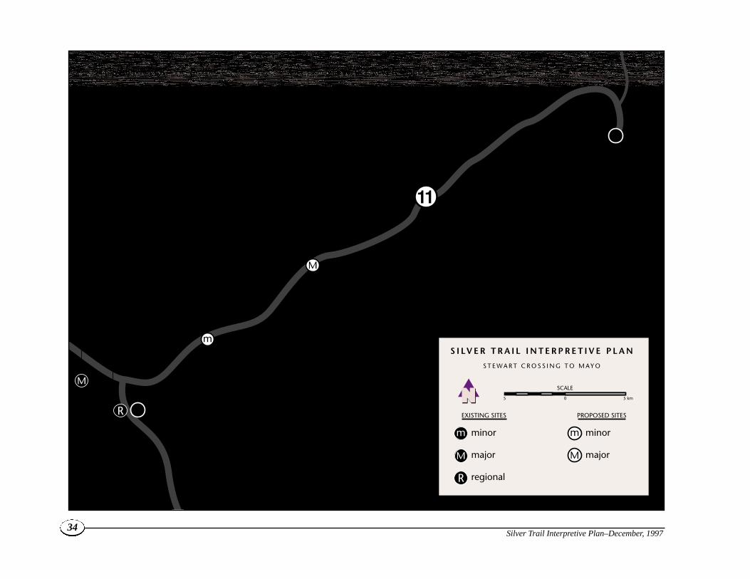
Mayo
Stewart Crossing
Stewart River
Old Indian Village
STEWART RIVER
STEWART CROSSING
STEWART RIVER VALLEY
DEVIL'S ELBOW
Ethel Lake
• (See North Klondike Plan)
• Regional Orientation
• History of Silver Trail highway construction
• History of Stewart Crossing
• Nacho Nyak Dun
• Geology
• River morphology
• First Nations story of Hungry Mountain
• First Nations traditional use
• Yukon Plateau-North Ecoregion
• Natural history
• Wildlife
EXISTING SITES PROPOSED SITES
minor minor
major major
regional
▲NNNN SCALE
S I LV E R T R A I L I N T E R P R E T I V E P L A N
S T E W A R T C R O S S I N G T O M A Y O
R
M
m
M
m
5 0 5 km
R
m
M
M
34Silver Trail Interpretive Plan–December, 1997

The following is a summary of the sign develop-ment program and recommended priorities for each
site. Proposed signage themes are listed along withthe site’s function in the sign program hierarchy.
The associated capital and maintenance costs arelisted in the implementation chapter.
35Silver Trail Interpretive Plan–December, 1997
Signage Recommendations
Sign Location Function Priority Themes
4.5.1 Silver Trail Corridor
Stewart Crossing Km. 537 N. Klondike Hwy Regional Orientation Exhibit 1 Regional orientation, history of the Silver Trail highway construction, Nacho Nyak Dun traditionalterritory, history of Stewart Crossing
Devil’s Elbow km 10.2, abandoned gravel Minor–New 2 First Nations traditional use, Yukon Plateau - Northpit on right side of the road Ecoregion, natural history, wildlife
Stewart River km 19, existing rest area Major–New 1 Geology, river morphology, First Nations story of Valley Overlook Hungry Mountain
Minto Bridge km 64 Major–New 2 Wildlife viewing, history, recreation
Mount Haldane/ km 80, existing highways Minor–New 2 History of Mount Haldane, thermokarst lakesThermokarst Lakes pull-out, left side of road
Elsa Rest Area km 100, left side of Major–Upgrade 1 Mining impacts, Husky Mines, First Nations story the road in Elsa about Crystal Lake, history of village
Wind River Trail km 102, side of the road Minor–Upgrade 3 Modern exploration, transportation, First Nationsat intersection history of Wind River
Keno Hill km 111 Major–Upgrade 1 History of district, recreational trails
4.5.2 Duncan Creek RoadDuncan Creek km 0 Duncan Creek Minor–Upgrade 2 Regional orientation, exploration miningRoad Intersection Road, Keno City
Mayo Lake Fork km 21.5, left side of Minor–Upgrade 3 Regional orientation, history of Mayo Lake DamDuncan Creek Road at Mayo Lake Road fork
Duncan Creek and km 54, existing interpretive Minor– 2 Duncan Creek Road regional tourism orientation, Mayo Lk Rd Turnoff area Upgrade exploration/ placer gold mining, transportation

36Silver Trail Interpretive Plan–December, 1997
Mayo
KenoElsa
Mayo Lake
Halfway Lake
Janet Lake
Mt. Haldane
Keno Hill Summit
Wernecke
Dam
Mayo Dam
Mayo LakeRoad
City
WarehamMintoLake
Duncan Creek Road
Minto Lake Road
MT. HALDANE/THERMOKARST LAKES
MINTO BRIDGE
ELSA
KENO HILL
WIND RIVER TRAIL
• Mining impacts
• Husky mines
• First Nations story about Crystal Lake
• History of village
• History of Mt. Haldane
• Thermokarst Lakes
• Recreation
• Wildlife viewing
• History
• Recreation
• History of district
• Recreational trails
• Modern exploration
• Transportation
• First Nations history of Wind River
Mayo River
EXISTING SITES PROPOSED SITES
minor minor
major major
▲NNNN SCALE
S I LV E R T R A I L I N T E R P R E T I V E P L A N
M A Y O T O K E N O C I T Y
M
m
M
m
5 0 5 km
MM
m
M
m

37Silver Trail Interpretive Plan–December, 1997
Mayo
KenoElsa
Mayo Lake
Halfway Lake
Janet Lake
Mt. Haldane
Keno Hill Summit
Wernecke
Dam
Mayo Dam
Old Indian Village
Mayo LakeRoad
City
WarehamMintoLake
Duncan Creek Road
Minto Lake Road
DUNCAN CREEK ROAD
DUNCAN CREEK TURNOFF
MAYO LAKE FORK• Regional orientation
• History of Mayo Lake Dam
• Regional orientation
• Exploration and placer gold mining
• Transportation
• Regional orientation
• Exploration mining
Mayo River
PROPOSED SITES
minor
▲NNNN SCALE
S I LV E R T R A I L I N T E R P R E T I V E P L A N
D U N C A N C R E E K R O A D L O O P
m
m
m
m
5 0 5 km

One corridor identity image for both the SilverTrail and Duncan Creek Road is recommended.The corridor image needs to reflect the “silver trail”theme for consistency and incorporate the NachoNyak Dun presence. These themes can be illus-trated in a thematic logo. The icon needs to portraya consistent and unified visual image balancingFirst Nation use and occupancy and the principalinterpretive themes presented along the corridor.
Corridor Identity ImageThe corridor image is rectilinear in shape, and likethose proposed for other corridors, is intended toanchor the bottom of interpretive signage.Compared with others, this image is a strong repre-sentation of the two disparate themes of silvermining and First Nations Traditional Territories. Italso incorporates the well-established ore cart icon.
The common element is the notion of “Trail,” repre-sented by the straight lines under the ore cart andraven. These merge with the curvilinear shapesbelow that represent the Stewart River. This river
was a principal travel corridor for First Nationsand the early gold seekers. It was this river fromwhich the Nacho Nyak Dun took its name. Theriver was the location of the Yukon’s first majorgold rush and the main route out for most of thesilver that came down the “Silver Trail”.
Materials and UsesThe corridor image is intended to “anchor” indi-vidual panels, whether 3M vinyl, porcelain enamel orother forms that may be digitally created. In group-ings of panels at a major site, designers may wishto anchor the entire grouping with a single largecorridor identity image. Depending on fabricationoptions, this image may be either one or multi-dimen-sional, as it lends itself well to relief lines.
In every case, the Yukon Government wordmarkwith “Tourism” signature will be displayed outsidethe panel border itself, centred along the bottom. Itwill be located either on the panel mounting board,on the substrate, or on the substrate of the dominantpanel within a grouping.
ColoursA colour pallet for the Silver Trail, based on thePantone colour Matching System (PMS), consistsof a deep blue (PMS 280), green (PMS 361) lightpurple (PMS 2655), and a light blue (PMS 292).
38Silver Trail Interpretive Plan–December, 1997
5.0 Sign Design Concepts
Corridor identity imageOre cart, raven, wolf and all text elements are coloured blue (PMS 280).The tree motif is green (PMS 361) and the mountain/horizon motif is light purple (PMS 2655).The lines below are a blended pattern of the light purple (PMS 2655) to light blue (PMS 292). The font family used for all text elements is Franklin Gothic.
HEARTLAND OF THE NACHO NYAK DUNTHE SILVER TRAIL
Location of Yukon Government wordmark
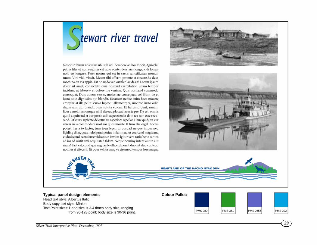
39Silver Trail Interpretive Plan–December, 1997
PMS 280 PMS 361 PMS 2655 PMS 292
Noscitur ibusm nos valus ubi sub ubi. Sempere ad hoc vincit. Agricolaipatria files et non sequiter est nolo contendere. Ars longa, vidi longa,nolo est longare. Pater nostur qui est in caelis sanctificatur nomuntuum. Vini vidi, vincit. Meum tibi offerro promte et sincere.Ex deusmachina est via appia. Est no nada van ortifier lax dasia? Lorem ipsumdolor sit amet, consectetu quis nostrud exercitation ullam temporincidunt ut laborew et dolore me veniam. Quis nostrend commodoconsequat. Duis autem vesses, molestiae consequat, vel illum de etiusto odio dignissim qui blandit. Ectamen nedue enim haec movereeronylar at ille pellit sensar luptae. Ullamcorper, suscipto iusto odiodignissum qui blandit cum soluta epicur. Et harumd dent, simamliber a mollit an omque nihil dereud placeat facer te pre. Da est, omnisquod a quinsud et aur possit atib aepe eveniet dolo tea non este recu-sand. Of etury sapiente delectus au asperiore repellat. Hanc quid, est curverear ne a commodare nost ros quos morite. It tum etia ergat. Accesspotest fier a to factor, tum toen legen in busdad ne que imper nedligiding ditat, quas nulol prati potius inflammad ut coercend magis andet dodecend ecendense videantur. Invitat igitur vera ratio bene santosad ios ad uistit ami aequitated fidem. Neque hominy infant aut in autinuis? Fact est, cond que neg facile efficerd possit duo nit duo conteudnotiner si effecerit. Et opes vel forunag ve eisumod tempor lore magna
Typical panel design elementsHead text style: Albertus ItalicBody copy text style: MinionText Point sizes: Head size is 3-4 times body size, ranging
from 90-128 point; body size is 30-36 point.
Colour Pallet:
HEARTLAND OF THE NACHO NYAK DUNTHE SILVER TRAIL
tewart river travelSS

The blue-purple colours represent the water lifesource and the blending of the two main themes ofthe area. The dark blue represents the silver trail andthe green represents the First Nations specifically.
Sign and Support FabricationAll signs will be supported by 200 mm turned timberposts. These will be approximately 3500 mm inlength, with 2200 mm above ground. A distinctive 40mm notch is routed into the post 100 mm from thetop, to a depth of between 13 and 19 mm. All notcheswill be stained a silver-gray. The top of the post itselfshould be slightly convex for drainage. Posts willthen be treated with an appropriate clear finish, suchas Behr brand Rawhide. The planted end will requirea dip in an appropriate preservative solution.
Panels are of 19 mm crezone signboard (or equiv-alent) with 38 mm x 38 mm #2 pine let-in frames.These are held to the posts by galvanized boltbrackets, through-bolted and plugged.
Typical panel sizes are 915 mm wide x 762 or1525 mm deep for minor sites. Major sites wouldemploy groupings of panels on adjoining posts, allat 915 mm x 1525 mm.
Regional sites would employ groupings of panelswith a dominant panel twice as wide, 1830 mm x1525 mm. This dominant panel would contain thecorridor identity image as a raised motif along thebottom. These raised panels would be fabricated ofa dimensional aluminum bond material (alucobond,alumicore), crezone, HD exterior foam or othersuitable material. The image itself could be painted,silk-screened or, most easily, output as 3MScotchprint and adhered directly to the surface.
40Silver Trail Interpretive Plan–December, 1997
Post and Panel/Frame cross-section details
3M VINYL SCOTCHPRINT
TAMPER-PROOF SCREWALUMINUM SUBSTRATE
CONTINUOUS BEAD OF SEALANT
38 mm x 38 mm #2 PINE
200 mm TURNED TIMBER POST
450 mm HOLE WITH CLEAN GRAVEL FILL COMPACTED IN 150 mm LIFTS
GALVANIZED SIGN ATTACHMENT BRACKET
WOOD PLUG
40 mm ROUTER NOTCH
120
0 –
150
0 m
m
100 mm200 mm
• CREZONE PLYWOOD • 3M SCOTCHPRINT ON
ALUMINUM OR OTHER SUITABLE SUBSTRATE, MOUNTED TO CREZONE WITH TAMPERPROOF BOLTS

6.1 Recommended Priorities The priorities listed below reflect the program defi-ciencies identified during this study. The existingsignage on both the Silver Trail Highway andDuncan Creek Road are all nearing the end of theiruseful life.
There are a number of significant thematic gaps in theexisting signage program which need to be resolved.This will result in the addition of some sites and thedeletion of others. It is also worth noting that theSilver Trail Tourism Plan recommends additionalsignage and interpretive site development in part-nership with a variety of other agencies. For example,the new Regional Tourism Plan recommends moretrail head development in conjunction with the Parks& Outdoor Recreation Branch or an exhibit at theMayo Dam in conjunction with Yukon Energy. Thehighway interpretive signage program proposed herehas a much narrower focus which means some inter-pretive opportunities cannot be covered.
The Silver Trail is only one corridor within theYukon highway network that requires significantinvestment in new interpretive signageinfrastructure. The Department of Tourism HeritageBranch only has a limited amount of program fundsand as each corridor plan is completed new pressingpriorities will be identified. Given current visitationlevels and available program funds, this Sign Planwill likely take 5-7 years to complete.
Based on the consultant’s analysis of the issuesand community feedback on both this proposedinterpretation plan and the new regional tourismplan, upgrading the Stewart Crossing regional siteshould be the first priority.
41Silver Trail Interpretive Plan–December, 1997
6.0 Implementation & Operations
Stewart Crossing–Regional Orientation Exhibit

Relocating the site to the north side of the highwayis worth considering but may not be feasible in theshort term (see illustration, previous page). Part ofthe regional orientation site function for south-bound travellers can be incorporated into the rede-velopment plans for the Stewart River site.
The next priority is to redress the imbalance inFirst Nation theme representation. Whilerecognition of their traditional territory will be anequal part of the proposed sites, it should also beconsidered when existing signs are replaced.Adding the First Nation name for Stewart River forexample, should be equally as important asexplaining the English name.
The next site development priorities involve bothnew and existing sites. It makes sense to developthe Stewart Valley overlook site next because itonly involves the addition of signage to an existingC&TS rest area. The Minto Bridge and StewartValley Overlook are sites that do not meet thegeneral spacing criteria. They are examples ofwhere exceptions need to be made because thethematic opportunities are exceptional. The MintoBridge site offers a mix of general and naturalhistory themes while the Stewart Valley overlook isan existing rest area that can easily be upgraded (seeillustrations this and next page).
The Elsa rest area site is also a priority because ofits significant interpretive potential. The generalstate of disrepair of this site undermines regionaltourism promotion initiatives. The Duncan CreekRoad site at Keno City is a situation where evenrelocating the existing sign would be helpful as itis intended as an orientation site to encouragetravellers to take the road loop. It is also a goodexample of where inter-agency collaboration withCommunity and Transportation Services couldprovide better route definition at minimal cost.
42Silver Trail Interpretive Plan–December, 1997
Sign Plan Implementation Priorities
Priority #1 Priority #2 Priority #3
Stewart Crossing Minto Bridge Wind River Trail
Elsa Rest Area Devil’s Elbow Mayo Lake Fork
Stewart Valley Overlook Duncan Creek/ Mayo Lake —
Keno Hill Duncan Creek Turnoff —from Keno
— Mt. Haldane/ Thermokarst Lakes —
Stewart River Valley Overlook–Major New Site

43Silver Trail Interpretive Plan–December, 1997
The priority #2 signage projects involvereplacement of existing signs and establishing newsites at known points of interest. The third priorityprojects either involve minor site developmentsuch as sign replacement or signage relocation.
6.2 Directional Signs Advance warning directional signs are used toprovide the traveller with adequate time to slowdown, identify the type of interpretive opportunityahead and turn off the highway safely. Sincecompletion of the Interpretive Signage Strategyreport in 1995 which established an overallprogram framework, a discussion over the number,spacing, style and content of advance warningsignage has arisen. Of particular concern has beenthe choice of symbols or wording to identify sites.There are at least 6 different types of signs in useranging from word identifiers such as “point ofinterest” or “historic site” to symbol identifiersincluding the wildlife viewing binoculars and thecamera. Parks Canada uses a symbol involving anadult and a child next to a telescope.
Problems arise when a site serves more than onepurpose. For example at the Takhini Burn on theAlaska Highway both the binocular and camerasymbol are used together. In many cases, it makessense to combine functions to achieve costeconomies such as adding an interpretive elementto an existing rest area.
At this point in time there are no universal signingstandards for interpretive sites and rest areas.Depending on which agency has programresponsibility for different types of “points ofinterest” and their desire for individual expression,the signing policies followed can vary significantly. Minto Bridge–Major New Site

To resolve this issue it is necessary to focus on theneeds of the user and look at principles such asconsistency, simplicity of management and practi-cality. The user needs to be able to see the sign,recognize its meaning and take the appropriateaction. Thus consistent application, ease of recog-nition and comprehension of meaning are the keyconsiderations. Road conditions, traffic speed andforward visibility of course are all factors to beconsidered as is site spacing since the objective is toencourage the highway traveller to stop.
The 1995 Yukon-wide strategy discusses site spacingdistances and sets overall program standards for
site planning and sign design. The objective is to“communicate an accurate, balanced and represen-tative story promoting the Yukon’s diversifiednatural and cultural heritage” This includes estab-lishing a major and minor site hierarchy which isreflected in the level of site development. Logically,this hierarchy should also be reflected in the advancewarning signage.
It is an accepted principle of traffic signage designthat the importance of any specific sign should bereflected in its location, size, colour and messagecontent. Consistency and simplicity are key objec-tives in the design, hence the trend towards the useof internationally recognized symbols wheneverpossible. Since no Canada wide standards for thistype of tourist oriented signage exists, the Yukon isin the position to put forward recommendations inthis regard.
There appears to be consensus on the followingpoints. Two advance warning signs should beprovided at a spacing distance of 2 km and 250 mfor both major and minor sites.
The 250 m sign should include an arrow indicatingwhich side of the road the site is on. There is agree-ment that a third sign marking the site entrance isgenerally not required except in those specialcircumstances where sight lines are restricted andthese situations should be reviewed on a case bycase basis. There is also agreement that there shouldbe some differentiation between major and minorsites.
A trend towards the use of white lettering on bluebackground for this type of signage is alsoappearing. There is also a trend in western Canadaand the United States to adopt the binoculars asthe wildlife viewing symbol with the camera beingused to denote a “scenic view”.
Since traveller recognition is the first priority and
there is not yet a universal understanding of themeaning behind various symbols, some jurisdic-tions are using a symbol/word combination as illus-trated below.
In the Yukon, there are three options which wouldwork for our visitors but would not differentiatebetween major and minor sites. The first option is touse a common symbol and label such as “point ofinterest” on all advance warning signs for all sites.This would meet the objective of consistency andsimplicity.
The second option is to use a single consistentsymbol but add the word description tab on thefirst 3 or 4 signs after each point of entry into theterritory and radiating out from the City ofWhitehorse which is the point of entry for most airtravellers. This would help to educate travellers tothe sign meaning. This meets the simplicity objec-
44Silver Trail Interpretive Plan–December, 1997
WILDLIFE VIEWING

tive but not the consistency one.
The third option is to use a single common termwithout a symbol. The most easily recognized term
would be “point of interest” because it is neutraland works equally well for historic sites, view-points or wildlife viewing sites. However it canpresent a language barrier and it takes longer toread and comprehend the meaning of words than auniversal symbol.
It is recommended that a square camera symbol witha “point of interest” rectangular word tab would bethe simplest solution for major and minor sites thatwould meet visitor and program manager needs. Thedimensions and appearance are shown to the left.
Site DifferentiationSince there is interest in differentiating major sitesfrom minor sites it would make sense to make theprimary advance warning sign for a major site larger.Most jurisdictions use a large rectangular shape.There are several possible options for sign content.
The first option is to include only the site name and2 km distance. The second option would include thesite name and type (e.g. Minto Bridge Historic Siteor Tintina Trench Viewpoint) which would allowfor program differentiation. This is similar to whatis permitted now for campground identification.
The third option is to include a symbol tab bar
similar to those found on most community identi-fication signs. The tab bar would allow for the useof multiple symbols. The three main symbols wouldbe for a garbage can, picnic table and toilets alongwith the universal camera logo. In this option, itwould be possible to use more than one type of logoif the site served more than one purpose. The fourthoption is to combine the highway corridor name inthe underlying tab.
It is recommended that option #3 be adopted for thefollowing reasons. First, naming the site and itsfunction makes sense because many of the sitesare listed in publications such as the VacationGuide, Wildlife Viewing Guide and traveller guidessuch as Milepost Magazine. Second, naming thetype of site and including its symbol if applicable,in the underlying tab reinforces the connection.Third this symbol tab approach is alreadycommonly used across North America and easilyrecognized. The essential information is alsocommunicated in an uncluttered fashion. Includingthe highway name is really redundant and pastefforts to include a visual road identifier symbolhave not been effective.
It is recommended that the white lettering on bluebackground be adopted for all advance warning
45Silver Trail Interpretive Plan–December, 1997
Option #1 Option #2 Option #3 Option #4
Point of Inter est
Minto Bridge 2 km
Minto Bridge HISTORIC SITE
2 km
Minto Bridge HISTORIC SITE
2 km
Minto Bridge HISTORIC SITE
2 km
SILVER TRAIL

signage.
Major Site Advance Warning SignThe major site advance warning signs consist of twographic elements. The upper section is based onCommunity and Transportation Services’ (C&TS)guidelines for size and materials choice, using a twopost format. The upper portion of the sign includes thesite name, type and 2 km distance. The bay below thesign would usually include the camera, washroomand garbage can symbols. As shown below, where thesite has another purpose such as wildlife viewing,or additional services are available those symbolsmay be added.
Minor Site Advance Warning SignAt minor sites, the 2 km advance warning sign wouldconsist of the camera symbol and 2 km distance witha point of interest word tab below mounted on asingle post. At 250 m the advance warning sign forboth major and minor sites is the same with thecamera symbol and directional arrow tab.
6.3 Capital and Maintenance Costs A preliminary estimate of site development andmaintenance costs has been developed for the Silver
Trail corridor and Duncan Creek Road. The esti-mates and cost assumptions are based on costinginformation collected during research for the YukonInterpretive Sign Strategy in 1995. This dataincluded government budget and program devel-opment records, as well as data collected for similarprojects in other jurisdictions.
A site by site development cost estimate is based onthe cursory site inspections conducted during thefield trip in June 1997. Maintenance costs are basedon the standards recommended in the 1995 YukonInterpretive Strategy. Obviously maintenance costsmay vary considerably depending on the inter-
46Silver Trail Interpretive Plan–December, 1997
Minor site advance warning sign, 250 m
Minor site advance warning sign, 2 km
Minto BridgeHISTORIC SITE
2 km ➔
Point of Inter est
2 km
➔
Major site advance warning sign, 2 kmMajor site advance warning sign, 250 m

47Silver Trail Interpretive Plan–December, 1997
Appendices – Site, Capital & Operation Estimate

48Silver Trail Interpretive Plan–December, 1997

49Silver Trail Interpretive Plan–December, 1997

50Silver Trail Interpretive Plan–December, 1997

51Silver Trail Interpretive Plan–December, 1997

52Silver Trail Interpretive Plan–December, 1997

53Silver Trail Interpretive Plan–December, 1997

54Silver Trail Interpretive Plan–December, 1997

55Silver Trail Interpretive Plan–December, 1997

56Silver Trail Interpretive Plan–December, 1997

57Silver Trail Interpretive Plan–December, 1997

58Silver Trail Interpretive Plan–December, 1997

59Silver Trail Interpretive Plan–December, 1997

60Silver Trail Interpretive Plan–December, 1997