Significance ofclay mineral assemblages in the …epic.awi.de/703/1/Ehr1992c.pdf · Significance...
26
Marine Geology, 107 (1992) 249-273 Elsevier Science Publishers RV., Amsterdam Significance of clay mineral assemblages in the Antarctic Ocean Werner U. Ehrmann, Martin Melles, Gerhard Kuhn and Hannes Grobe Alfred Wegener Institute/or Polar and Marine Research, Bremerhaven, Germany (Received July 17, 1991; revision accepted February 24, 1992) ABSTRACT Ehrmann, W.U., Melles, M., Kuhn, G. and Grobe, H., 1992. Significance of clay mineral assemblages in the Antarctic Ocean. Mar. Geol., 107: 249-273. 249 Typical examples from different morphological and geological settings in the Antarctic Ocean are reviewed in order to discuss the value of clay mineral assemblages for reconstructing the glacial history of Antarctica, the paleoceanographic history of the Antarctic Ocean and the sedimentary processes at the Antarctic continental margin. The significance of clay minerals for paleoenvironmental reconstructions strongly varies with both the position of the sites under investigation and the age of the sediments. In late Mesozoic to Paleogene sediments clay mineral assemblages are sensitive tools for reconstructing climatic conditions. For example, the shift from smectite-dominated assemblages to illite- and chlorite-dominated assemblages in the earliest Oligocene clearly documents the transition from chemical weathering conditions under a warm and humid climate to physical weathering under cooler conditions. Submarine elevations such as Maud Rise and Kerguelen Plateau give the best record for direct paleoclimatic and paleoceanographic studies. At the proximal sites of the continental slope and shelf, as well as in the deep sea, the paleoclimatic information normally is masked by a variety of processes resulting in sediment redistribution. At those sites, in contrast, the clay mineral assemblages bear a wealth of information on different sedimentary processes. After the establishment of a continental East Antarctic ice sheet, physical weathering prevailed. Variations in the clay mineral records predominantly reflect the influence of different sediment sources resulting from different glacial, hydrographic or gravitational transport processes. Because these sedimentation processes are generally linked to climatic variations, the clay mineral assemblages in most of the Neogene and Quaternary sediments provide indirect paleoclimatic information. The processes are best documented in the clay mineral composition in those areas where changes in source regions with distinct petrographic differences are expected and where distances from the source region are low. Introduction A large part of the clay minerals accumulating in the ocean close to continents is derived from land. There they were provided by physical or chemical weathering processes from a variety of lithologies. The clay mineral types and the propor- tions of the individual clay minerals in marine sediments therefore depend on the climatic condi- tions on land and on the nature of the source rocks. The distribution of different clay minerals in the present-day oceans reveals a latitudinal Correspondence to: W.U. Ehrmann, Alfred Wegener Institute for Polar and Marine Research, Bremerhaven, Germany. zonation that strongly reflects the pedogenic zona- tion and climatic conditions on the adjacent conti- nental land masses (Biscaye, 1965; Griffin et al., 1968; Lisitzin, 1972; Windom, 1976). Clay mineral assemblages in marine sedimentary sequences are, therefore, useful tools for reconstructing the paleo- climate through time. However, the small size of the clay minerals makes them prone to erosion, transport and redistribution by different media, such as wind transport, fluviatile transport, as well as transport and erosion by bottom currents or gravitational sediment movements. Thus, clay min- erals may also be useful tools for deciphering and reconstructing sedimentary processes. In high latitudes Cenozoic climatic variations 0025-3227/92/$05.00 © 1992 - Elsevier Science Publishers B.V. All rights reserved.
Transcript of Significance ofclay mineral assemblages in the …epic.awi.de/703/1/Ehr1992c.pdf · Significance...
Marine Geology, 107 (1992) 249-273Elsevier Science Publishers RV., Amsterdam
Significance of clay mineral assemblages in theAntarctic Ocean
Werner U. Ehrmann, Martin Melles, Gerhard Kuhn and Hannes GrobeAlfred Wegener Institute/or Polar and Marine Research, Bremerhaven, Germany
(Received July 17, 1991; revision accepted February 24, 1992)
ABSTRACT
Ehrmann, W.U., Melles, M., Kuhn, G. and Grobe, H., 1992. Significance of clay mineral assemblages in the Antarctic Ocean.Mar. Geol., 107: 249-273.
249
Typical examples from different morphological and geological settings in the Antarctic Ocean are reviewed in order todiscuss the value of clay mineral assemblages for reconstructing the glacial history of Antarctica, the paleoceanographic historyof the Antarctic Ocean and the sedimentary processes at the Antarctic continental margin. The significance of clay mineralsfor paleoenvironmental reconstructions strongly varies with both the position of the sites under investigation and the age ofthe sediments.
In late Mesozoic to Paleogene sediments clay mineral assemblages are sensitive tools for reconstructing climatic conditions.For example, the shift from smectite-dominated assemblages to illite- and chlorite-dominated assemblages in the earliestOligocene clearly documents the transition from chemical weathering conditions under a warm and humid climate to physicalweathering under cooler conditions. Submarine elevations such as Maud Rise and Kerguelen Plateau give the best record fordirect paleoclimatic and paleoceanographic studies. At the proximal sites of the continental slope and shelf, as well as in thedeep sea, the paleoclimatic information normally is masked by a variety of processes resulting in sediment redistribution. Atthose sites, in contrast, the clay mineral assemblages bear a wealth of information on different sedimentary processes.
After the establishment of a continental East Antarctic ice sheet, physical weathering prevailed. Variations in the clay mineralrecords predominantly reflect the influence of different sediment sources resulting from different glacial, hydrographic orgravitational transport processes. Because these sedimentation processes are generally linked to climatic variations, the claymineral assemblages in most of the Neogene and Quaternary sediments provide indirect paleoclimatic information. Theprocesses are best documented in the clay mineral composition in those areas where changes in source regions with distinctpetrographic differences are expected and where distances from the source region are low.
Introduction
A large part of the clay minerals accumulatingin the ocean close to continents is derived fromland. There they were provided by physical orchemical weathering processes from a variety oflithologies. The clay mineral types and the proportions of the individual clay minerals in marinesediments therefore depend on the climatic conditions on land and on the nature of the sourcerocks. The distribution of different clay mineralsin the present-day oceans reveals a latitudinal
Correspondence to: W.U. Ehrmann, Alfred Wegener Institutefor Polar and Marine Research, Bremerhaven, Germany.
zonation that strongly reflects the pedogenic zonation and climatic conditions on the adjacent continental land masses (Biscaye, 1965; Griffin et al.,1968; Lisitzin, 1972; Windom, 1976). Clay mineralassemblages in marine sedimentary sequences are,therefore, useful tools for reconstructing the paleoclimate through time. However, the small size ofthe clay minerals makes them prone to erosion,transport and redistribution by different media,such as wind transport, fluviatile transport, as wellas transport and erosion by bottom currents orgravitational sediment movements. Thus, clay minerals may also be useful tools for deciphering andreconstructing sedimentary processes.
In high latitudes Cenozoic climatic variations
0025-3227/92/$05.00 © 1992 - Elsevier Science Publishers B.V. All rights reserved.

250
and erosional processes both on land and at thecontinental margin were specially pronounced.Therefore, in these regions clay minerals are predestinated as indicators of modifications in theenvironment and complement the paleoclimaticinformation provided by other indicators.
To assess the long-term record of the development of paleoenvironmental conditions, glacialhistory and paleoceanography, the recovery oflong sediment cores is required. Therefore, studiesof Mesozoic and Cenozoic conditions mainly relyon sediment cores from the drilling ships of theDeep-Sea Drilling Project (DSDP) and the OceanDrilling Program (ODP). The investigation of claymineral assemblages on these cores has become astandard method. In contrast, in almost exclusivelyQuaternary sediments sampled by gravity, piston,phleger and box corers from the Antarctic Ocean,only few clay mineral analyses were carried out.One reason for that may be that the AntarcticQuaternary sediments were often described toreveal only minor fluctuations in the clay mineralcomposition (Anderson et al., 1980; Elverhei andRoaldset, 1983; Pudsey et aI., 1988; Wessel, 1989).
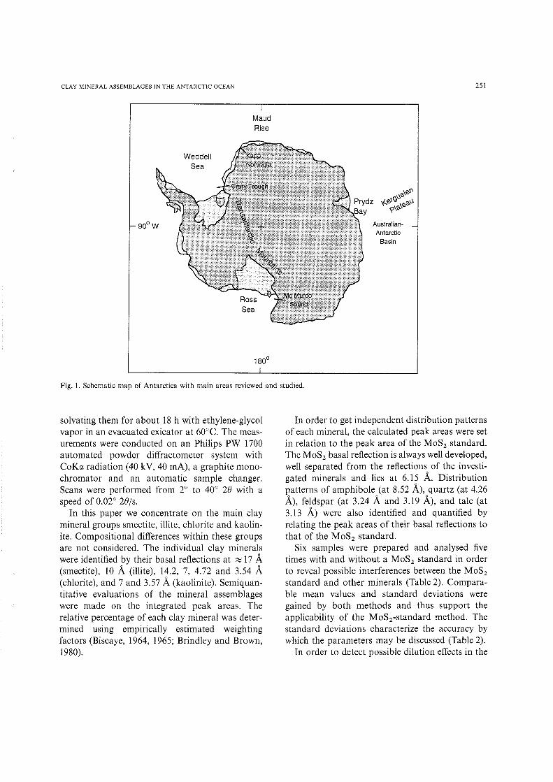
This paper discusses the significance of claymineral assemblages in the Antarctic Ocean inrespect to decipher the paleoceanographic historyof the Antarctic Ocean, the glacial history ofAntarctica and the sedimentary processes at theAntarctic continental margin. However, it doesnot intend to discuss the climatic evolution of thesouthern high latitudes, which already has beenreconstructed in great detail (e.g. Robert and Maillot, 1990; Grobe et al., 1990a; Ehrmann, 1991).For evaluating the significance of clay minerals,typical examples from different morphological andgeological settings, such as the continental shelf,the continental slope, the adjacent deep-sea andisolated submarine elevations are investigated orreviewed. The material and examples presented inthis study mainly come from several expeditionsof the Ocean Drilling Program and of the AlfredWegener Institute for Polar and Marine Research(Fig. .1; Table 1).
Methods
Clay mineral studies based on X-ray diffraction(XRD) often present semiquantitative data gained
W.U. EHRMANN ET AL.
by different approaches (McManus, 1991). Oneapproach is to calculate ratios between peak areasor peak intensities of two minerals. Another possibility is to calculate relative percentages based onweighted peak areas. Both methods, however, donot provide absolute proportions of individualminerals. An approach to gain an independentdata base for each mineral would be to calculateaccumulation rates. However, especially in thesouthern high latitudes, this approach is hamperedby the presence of additional minerals in the clayfraction ( < 2 urn), such as several types of feldspar,which cannot be quantified easily. Hence, we havechosen an internal standard method in order toquantify the minerals in the clay fraction.
Bulk sediment samples were oxidized and disaggregated by means of a 3-10% HzO z solution.After sieving the samples through a 63 urn mesh,the clay fraction was isolated from the fine fractionby the Atterberg method (settling time based onStoke's Law). 10-30 ml of a 50% MgCl z solutionwas added to the clay suspension (up to 5 1) inorder to charge the clay minerals and make themsink by agglomeration. Subsequently, excess ionswere removed by double centrifugation with destilled water, and the samples were dried at atemperature of 60°C. In case larger amounts ofcarbonate or amorphous silica were present, thesecomponents were removed by 10% acetic acid,respectively a three minutes treatment with a boiling 2 M NaZC0 3 solution.
After grinding the clay in an agate mortar,40 mg were dispersed in an ultrasonic bath andmixed with 1 ml of a 1% MoS z suspension (0.3 urngrain-diameter). We preferred MoS z rather thanthe often used talc standard (McManus, 1991),because talc is a component of the < 2/lm fractionin sediments of the southern high latitudes (Melles,1991), whereas MaS, does not occur in sediments.Texturally oriented aggregates were produced byrapidly filtering the suspension with a vacuumpump through a membrane filter of 0.15 urn porewidth (Lange, 1982). The filter cakes were driedat 60°C while being pressed between waxpaper anda porous plate. Subsequently, they were mountedwith double-sided adhesive tape onto 3 cm? aluminium tiles and placed into aluminium sampleholders. The samples were analysed by XRD after
CLAY MINERAL ASSEMBLAGES IN THE ANTARCTIC OCEAN
MaudRise
WeddellSea
Fig.!. Schematic map of Antarctica with main areas reviewed and studied.
AustralianAntarctic
Basin
251
solvating them for about 18 h with ethylene-glycolvapor in an evacuated exicator at 60°C. The measurements were conducted on an Philips PW 1700automated powder diffractometer system withCoKa radiation (40 kV, 40 mA), a graphite monochromator and an automatic sample changer.Scans were performed from 2° to 40° 28 with aspeed of 0.02° 28/s.
In this paper we concentrate on the main claymineral groups smectite, illite, chlorite and kaolinite. Compositional differences within these groupsare not considered. The individual clay mineralswere identified by their basal reflections at :::::; 17 A(smectite), 10 A (illite), 14.2, 7, 4.72 and 3.54 A(chlorite), and 7 and 3.57 A (kaolinite). Semiquantitative evaluations of the mineral assemblageswere made on the integrated peak areas. Therelative percentage of each clay mineral was determined using empirically estimated weightingfactors (Biscaye, 1964, 1965; Brindley and Brown,1980).
In order to get independent distribution patternsof each mineral, the calculated peak areas were setin relation to the peak area of the MoS 2 standard.The MoS 2 basal reflection is always well developed,well separated from the reflections of the investigated minerals and lies at 6.15 A. Distributionpatterns of amphibole (at 8.52 A), quartz (at 4.26A), feldspar (at 3.24 A and 3.19 A), and talc (at3.13 A) were also identified and quantified byrelating the peak areas of their basal reflections tothat of the MoS 2 standard.
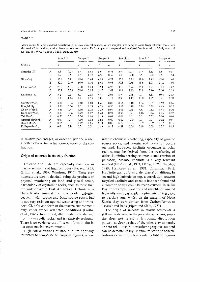
Six samples were prepared and analysed fivetimes with and without a MoS 2 standard in orderto reveal possible interferences between the MoS 2
standard and other minerals (Table 2). Comparable mean values and standard deviations weregained by both methods and thus support theapplicability of the Mo'Sj-standard method. Thestandard deviations characterize the accuracy bywhich the parameters may be discussed (Table 2).
In order to detect possible dilution effects in the

252 W.U. EHRMANN ET AL.
TABLE I
Sites studied and reviewed, site location, water depth and references to existing clay mineral studies. ODP= Ocean Drilling Programlegs; ANT= Antarctic expeditions of the Alfred Wegener Institute
Site Expedition Location Geographic Position Water Authorno. setting depth (m)
689 ODP 113 Maud Rise elevation 64°31.0 I 'S 2080 Robert and Maillot, 1990; Ehrmann and03°06.00'E Mackensen, 1992; this study
690 ODP 113 Maud Rise elevation 65°09.63'S 2914 Robert and Maillot, 1990; Ehrmann and01012.30'E Mackensen, 1992; this study
693 ODP 113 Kapp slope 70049.89'S 2359 Grobe et al, 1990b; Robert and Maillot,Norvegia W34.41'W 1990; this study
694 ODP 113 Weddell deep sea 66°50.82'S 4653 Robert and Maillot, 1990Basin 32°26.76'W
738 ODP 119 Kerguelen elevation 62°42.54'S 2253 Ehrmann, 1991; Ehrmann and Mack-Plateau 82°47.25'E ensen, 1992
739 ODP 119 Prydz Bay shelf 67°16.57'S 412 Hambrey et aI., 199175°04.91'E
742 ODP 119 Prydz Bay shelf 67°32.98'S 416 Hambrey et aI., 199175°24.27'E
744 ODP 119 Kerguelen elevation 6n4.66'S 2307 Ehrmann, 1991; Ehrmann and Mack-Plateau 80035.46'E ensen, 1992
745 ODP 119 Ant.-Austr. deep sea 59°35.71 'S 4082 Ehrmann et aI., 1991; Ehrmann andBasin 85°51.78'E Grobe, 1991
746 ODP 119 Ant.-Austr. deep sea 59°32.82'S 4059 Ehrmann et aI., 1991Basin 85°51.78'E
CIROS-l McMurdo shelf 7r34.55'S 200 Claridge and Campbell, 1989Sound 164°29.56'E
PSI400 ANT-IVj3 Crary shelf 77°33.05'S 1061 Melles, 1987; this studyTrough 36°24.10'W
PS1606 ANT-VIj3 Weddell slope 7nO.08'S 2938 Melles, 1991Sea 34°01.24'W
67 ANT-IVj3, eastern continental various 140 this studysurface ANT-Vj4, Weddell margin tosamples ANT-VIj3 Sea 4541
72 ANT-IVj3, southern continental various 369 Melles, 1991; this studysurface ANT-Vj4, Weddell margin tosamples ANT-VIj3 Sea 2933
samples investigated for this paper, we graphicallycompared the clay mineral percentage curves withthe mineral/McS, curves. In general, the visualcorrelation was convincing. We also calculatedcorrelation coefficients between the percentagesand the mineral/McSy-ratios. In the case of smectite, the correlation coefficientsvaried between 0.70and 0.94. Poorest correlation was found insequences with smectite contents > 90%, where
the integration of the smectite peak areas was mostinaccurate. In the case of illite, correlation coefficients were 0.80-0.90; in the case of kaolinite, theywere 0.87-0.96. For chlorite we calculated correlation coefficients of 0.67-0.83. In contrast to smectite, here we do not know the cause for theoccasionally poor correlation. Because of the relatively good correlations between the two methods,we decided to present the clay mineral composition
CLAY MINERAL ASSEMBLAGES IN THE ANTARCTIC OCEAN
TABLE 2
253
Mean values (x) and standard deviations (0") of clay mineral analyses of six samples. The samples come from different cores fromthe Weddell Sea and were taken from various core depths. Each sample was prepared and analysed five times with a MoS 2 standard(A) and five times without a MoS 2 standard (B)
Sample I Sample 2 Sample 3 Sample 4 Sample 5 Sample 6
Statistic .'< 0" .'< 0" .'< 0" .'< 0" x 0" X 0"
Smectite (%) A 5.8 0.25 5.4 0.65 5.9 0.73 5.9 0.67 11.4 3.15 5.8 0.51B 5.9 0.51 4.9 0.32 6.2 0.57 5.5 0.80 8.5 0.78 7.5 1.54
Illite (%) A 62.1 3.91 68.0 3.64 60.3 4.72 50.1 1.95 49.0 1.95 49.4 1.46B 62.0 2.49 66.0 1.70 59.3 0.95 50.8 0.66 48.6 1.71 51.2 1.90
Chlorite (%) A 28.9 4.05 24.8 6.13 29.4 6.92 35.3 2.94 29.8 3.94 34.4 1.62B 30.8 2.75 28.0 2.05 31.5 2.48 34.8 1.83 31.9 2.96 32.0 3.18
Kaolinite (%) A 3.2 0.51 1.7 2.15 4.4 2.07 8.7 1.76 9.9 1.32 10.4 2.15B 1.3 1.44 1.1 0.55 3.0 1.17 8.9 1.12 11.0 1.29 9.4 2.18
Smectite/Mo'S, A 0.70 0.04 0.68 0.08 0.66 0.08 0.66 0.10 1.34 0.37 0.59 0.06Illite/MoS 2 A 7.56 0.64 8.51 0.53 6.76 0.30 5.61 0.18 5.79 0.18 4.99 0.17Chlorite/MoS2 A 3.51 0.47 3.10 0.78 3.37 0.96 3.96 0.35 3.53 0.52 3.48 0.20Kaolinite/MoS2 A 0.39 0.06 0.22 0.27 0.49 0.21 0.98 0.21 1.16 0.14 1.05 0.22Ta1c/MoS 2 A 0.20 0.05 0.26 0.06 0.13 0.03 0.01 0.01 0.01 0.02 0.00 0.00Amphibole/MoS 2 A 0.07 0.01 0.10 0.02 0.05 0.00 0.02 0.00 0.01 0.01 0.02 0.01Quartz/MoS2 A 0.16 0.05 0.12 0.05 0.19 0.Q7 0.27 0.05 0.39 0.09 0.37 0.15Feldspar/MoS2 A 0.64 0.14 0.71 0.28 0.49 0.15 0.29 0.06 0.40 0.09 0.35 0.15
in relative percentages, in order to give the readera better idea of the actual composition of the clayfraction.
Origin of minerals in the clay fraction
Chlorite and illite are especially common inmarine sediments of high latitudes (Biscaye, 1965;Griffin et aI., 1968; Windom, 1976). These clayminerals are mostly detrital, being the products ofphysical weathering on land and glacial scour,particularly of crystalline rocks, such as those thatare widespread in East Antarctica. Chlorite is acharacteristic mineral for low grade, chloritebearing metamorphic and basic source rocks, butis not very resistant against weathering and transport. Chlorite can form in the marine environmentonly under rather restricted conditions (Griffinet aI., 1968). In contrast, illite tends to be derivedfrom more acidic; rocks, and is relatively resistant.There is no evidence that illite can form in situ inthe open marine environment.
High concentrations of kaolinite are normallyrestricted to temperate to tropical regions, where
intense chemical weathering, especially of graniticsource rocks, and lateritic soil formation occurson land. However, kaolinite occurring in polarregions may be derived from the weathering ofolder, kaolinite-bearing sediments and erosion ofpaleosols, because kaolinite is a very resistantmineral (Naidu et aI., 1971; Darby, 1975;Chamley,1989; Hambrey et aI., 1991; Ehrmann, 1991).Kaolinite cannot form under glacial conditions. Inseveral high-latitude settings a correlation betweenrecycled kaolinite and smectite has been found anda common source could be reconstructed. In BaffinBay, for example, kaolinite and smectite originatedfrom offshore coastal plain sediments of Mesozoicto Tertiary age, whilst on the margin of NovaScotia they were derived from Carboniferous toTriassic red beds (Piper and Slatt, 1977).
The origin of smectite in marine sediments isstill under debate. In the present-day oceans, smectite does not reveal a latitudinal distributionpattern as clear as that of the other clay minerals,and no relationship to weathering regimes on landcan be detected easily. Maximum smectite concentrations occur in the temperate to subarid regions

254
of the South Atlantic, the central North Atlantic,the central and southern Pacific, and the northeastern Indian Ocean. It thus seems that smectiteforms by hydrolysis under climatic conditionsbetween those necessary for the formation ofkaolinite and those for chlorite and illite, i.e.between warm-humid and cold-dry conditions(Chamley, 1979,1989; Chamley et al., 1984). Often,however, smectite is assumed to be derived as aresult of submarine weathering (halmyrolysis) ofvolcanic material (e.g. Biscaye, 1965; further references in Kastner, 1981). This hypothesis is supported by the fact that smectite commonly is foundin marine regions where volcanic activity providingthe source rocks is high, and where at the sametime sedimentation rates are low, resulting in longexposure times for volcanic rocks and ashes, andwhere the input of terrigenous material is low andtherefore dilution is reduced (e.g. in the centralPacific Ocean).
For most of the smectite in sediments drilled inthe Antarctic Ocean a continental origin is assumed(Piper and Pe, 1977; Barker et al., 1988; Ehrmannand Mackensen, 1992). Evidence of chemicalweathering with smectite formation, however, havebeen reported from a few soils in Antarctica (Claridge, 1965; Claridge and Campbell, 1989; compilations in Campbell and Claridge, 1987, pp. 130 ff.and Chamley, 1989, pp. 26 ff.). Some Antarctictills also contain smectite (Bardin et al., 1979;Bardin, 1982).
In addition to the main clay mineral groupschlorite, illite, kaolinite and smectite, many otherminerals and amorphous components contributeto the composition of the clay fraction. The quantification of these components, even if they occurin very low concentrations, may provide importantinformation on the environmental conditions. Forexample, high amounts of talc and amphibole mayindicate magmatic and especially metamorphicsource rocks and by this may give further information on transport paths, transport processes andthe geology of the source area (Melles, 1991).
Examples from the Antarctic continental shelf
The Antarctic shelf area best investigated bydeep drilling is Prydz Bay, an embayment in East
W.U. EHRMANN ET AL.
Antarctica that opens to the Indian Ocean (Fig. 1).The Lambert Glacier and the Amery Ice Shelfdrain through Prydz Bay about a tenth of the EastAntarctic ice sheet. Four sites were drilled in PrydzBay along a S-N transect (Barron et al., 1989).Sites 739 and 742 (Table 1) are at a distance ofabout 140 km to the edge of the present-day iceshelf and may serve as typical examples for aglacial shelf setting. The clay minerals in thisspecial type of setting were investigated in orderto study the glacial influence on the clay mineralassemblages. Another point of interest was thevalue of clay minerals in such a proximal positionfor reconstructing glacial history and sedimentaryprocesses (Hambrey et al., 1991).
The sediments recovered at Sites 739 and 742are glacially influenced throughout. Mainly massive waterlain till and some lodgement till buildup most of the sequence. Some intervals of weaklystratified and well stratified diamictites also occurand are interpreted as proximal and distal glaciomarine sediments, respectively (Hambrey et al.,1991). The age of the sediments ranges from earlyOligocene (possibly late Eocene) to Holocene. Thetotal lack of microfossils in parts of the core andthe lack of age-diagnostic microfossils throughextended core intervals allowed only a rough dating of the sedimentary sequence (Barron et al.,1991 ).
In the deepest part of Sites 742 and 739, kaoliniteconcentrations average around 60%, but decreasecontinuously upcore to ea. 140 mbsf at Site 742and ea. 280 mbsf at Site 739 (Fig. 2; Hambreyet al., 1991). Higher in the core kaolinite concentrations remain constant at about 20%. The kinkin the concentration curves has an early Oligoceneage. The illite and chlorite concentrations show anopposite trend to that of kaolinite. In the lowerpart of the two sites, chlorite concentrations rangefrom 5 to 15%, in the upper part they reach 30%.Illite concentrations fluctuate around 20 and 60%in the lower and upper parts of both sites, respectively. Smectite shows concentrations fluctuatingbetween 2 and 20%. The highest smectite valuesare found in the Oligocene part of the sites (Fig. 2;Hambrey et aI., 1991).
The most striking feature in the clay mineraldistribution at Sites 739 and 742 is the high content

CLAY MINERAL ASSEMBLAGES IN THE ANTARCTIC OCEAN
~ >-s:.c Co >- >-s '" Cl Qi smecttte..0
.!:: Cl > (%)'5.
:;:; (5 0~ ;; e
Ql Ql 0 10 20Cl U5 :J et:
0
Inile(%)
20 40 60
Chlorile(%)
10 20 30 0
Kaolinile(%)
20 40 60
255
50 QlcQ)o.2 ~~~~g: f-----'l
100
150
200
250
300 ..' ..",-,"
Q) ....... •cQ)o
350 0.S!'is>-~Q)
C'.400 Q)
cQ)o0uiQ)
'0'0
450 'EC'.
Fig. 2. Clay mineral assemblages at ODP Site 739 on the continental shelf of Prydz Bay, southernmost Indian Ocean (data fromHambrey et al., 1991). Site 742 shows the same general concentration patterns. For legend see Fig. 7.
of kaolinite in lower Oligocene sediments (Fig. 2).Most of the kaolinite was interpreted as a recycledproduct, derived from the erosion of old kaolinitebearing sedimentary rocks or soils (Hambrey et aI.,
1991). The source of the kaolinite might be soughtin equivalent rocks to the Permian Amery Formation, which comprises sandstones with a kaoliniticmatrix (Trail and McLeod, 1969). Such rocks are

256
probably also filling the Lambert Graben beneaththe Lambert Glacier and the Amery Ice Shelf.
The facies of the lower Oligocene sedimentsillustrates that the grounding line of the ice shelfcomplex was close to Site 739 during that timeinterval and glaciation was stronger than today(Hambrey et aI., 1991). Sedimentological, paleontological and isotopic data indicate that a continental East Antarctic ice sheet had developed in theearliest Oligocene (e.g. Ehrmann and Mackensen,1992). The high kaolinite content can be directlylinked to this development. The earliest glaciersthat reached the sea probably eroded large quantities of soil and loose weathering products derivedfrom both basement rocks and sedimentary strataand transported this material into Prydz Bay.Later, when the ice sheet was fully established andall the unconsolidated detritus had been removedfrom the continent, the glaciers began to erodeunweathered rocks. Therefore, only minoramounts of kaolinite were provided. In contrast,illite and chlorite increased in concentration.
Illite and chlorite probably were provided bythe hinterland of Prydz Bay, where large quantitiesof appropriate source rocks occur. This area iscomposed mainly of migmatites and gneisses andsmaller areas of quartzites and schists (Trail andMcLeod, 1969; Craddock, 1982; Ravich and Fedorov, 1982). The origin of the smectite is less clear.It is possible that the smectite was recycled fromunknown preglacial sediments and soils. Thus,Bardin et al. (1979) and Bardin (1982) found soilsand tills in the Prince Charles Mountains containing largely illite and chlorite, but also some smectite and vermiculite. Smectite also might betransported by currents into Prydz Bay.
The setting of Prydz Bay is very similar to theRoss Sea shelf on the other side of East Antarctica(Fig. 1). Ross Sea sediments were sampled by theCIROS-l drilling operation in McMurdo Sound(Table I; Barrett, 1989). The core recovered a lowerOligocene to lower Miocene glacial sequence. Theupper Oligocene to lower Miocene clay mineralassemblages consist of illite and chlorite representative for physical weathering. In the lower Oligocene sediments, in contrast, large amounts ofsmectite are present. Around 60% of the clayfraction is composed of beidellite, a Fe-rich smec-
W.U. EHRMANN ET AL.
tite, which today forms in soils of forests orscrublands under a cool to cold temperate climate.A similar climate was therefore postulated for theearly Oligocene, with the Ferrar Dolerite as asource for the smectite (Claridge and Campbell,1989). In analogy to the lower Oligocene kaolinitemaximum in Prydz Bay, however, one also couldconclude that the smectite was derived from looseweathering products and ancient soils, which weretransported by glaciers into the sea, and that thesmectite thus represents the first phase of glacialscour.
At numerous sites on the Antarctic continentalshelf, lodgement tills of the last glacial period wererecovered by shallow coring (e.g. Domack et aI.,1980; Anderson et aI., 1983). Because lodgementtills are deposited from grounded ice, their claymineral composition directly reflects the composition of the source area. For example, in the CraryTrough, a more than 1200 m deep depression onthe southeastern Weddell Sea shelf (Fig. 1), the< 2 urn-fraction of the lodgement till contains relatively high amounts of kaolinite and quartz, andlow amounts of illite, talc, amphibole and feldspar.This composition indicates that sedimentary rocksare a significant component of the source area.The corresponding source is found in the northernTransantarctic Mountains, where Paleozoic sedimentary sequences of the Beacon Supergroup cropout (Stephenson, 1966; Weber, 1982) and are commonly rich in kaolinite (Piper and Brisco, 1975).The clay mineral composition of the lodgement tillis relatively constant with depth (Fig. 3; Melles,1987; Futterer and Melles, 1990). Thus, the sourcearea, and therewith the ice flow lines, did notchange significantly during the time span recorded.A comparable homogeneity of lodgement tills wasdetected on the Ross Sea continental shelf (Anderson et aI., 1980).
In surface sediments overlying the lodgement tillof Crary Trough, the kaolinite and quartz contentof the < 2 urn-fraction shows distinct maxima intwo regions at the shelf edge, in the southeasternCrary Trough and, less clear, off Berkner Island(Fig. 4). An opposite trend is shown by talc, amphibole, feldspar and illite (Fig. 5). These distributionpatterns indicate different source areas, differenttransport paths and/or different transport media.

CLAY MINERAL ASSEMBLAGES IN THE ANTARCTIC OCEAN 257
Amphibole! Quartz!MoS 2 Feldspar
0.050.10 0.5 1.0 1.5
Talc!MoS2
0.1 0.2 0.3
....... >- >- III-III s: Cl l:!.c C- O ::::l-",
.§. f! '0 - ~ E lIIite KaoliniteCl s: 0 0
.s:: :t:: ::::l ca:;::: ... 0a ...J , - ... (%) (%)ca c ....... , (J)Ql -> 63fLm
,0 (J)
(%) 050100 2 6 10 50 60 70 2 6 100 Q)
c ........ 222Q) ........ \2'§i§io0 ........"0 .......:r: -- -
C"-•.•••.•.
Q)cQ)oot5
2 'CDCL".
LEGEND
SandLithology: c'-J Sandy Clay
11~1J Sandy Silt
L::l Sandy Mud
r~~~~~~ Mud
Structures:
low bioturbation
medium bioturbation
intense bioturbation
crude stratification-~ ,good stratification
Fig. 3. Clay mineral assemblages at Site PSl400 in the Crary Trough, southern Weddell Sea, The location of the core is shown inFigs. 4 and 5.
High contents of kaolinite and quartz probablydocument the accumulation of physical weatheringproducts of sedimentary rocks. In the southeasternCrary Trough, mountain glaciers, such as theSchweitzer and Lerchenfeld Glacier, flow into theFilchner Ice Shelf or directly into the sea anddeliver significant amounts of sedimentary rockdebris from the northern Transantarctic Mountains (Fig. 4). This hypothesis is confirmed by thecomposition of ice-rafted pebbles (Oskierski,1988). The high kaolinite and quartz contents offBerkner Island, which however is documented byone sample only, may also document a glacialsupply of sedimentary rocks.
The kaolinite and quartz maxima at the shelfedge (Fig. 4) were interpreted as a result of transport and redistribution of fine material from thesouthern Crary Trough by the northward flowingIce Shelf Water (Melles, 1991). The high concentrations of illite (Fig. 5), talc, amphibole and feldspar document the flow of the Eastern Shelf Wateras part of the Antarctic Coastal Current. Theseminerals indicate a source in the surrounding ofthe eastern Weddell Sea, where magmatic andespecially metamorphic rocks of the crystallinebasement occur (Juckes, 1972; Wolmarans andKent, 1982; Oskierski, 1988). The physical wheathering products of this source area may be trans-

258
Kaolinite [%]
<6
6 - 11
.. >11
W.U. EHRMANN ET AL.
Fig. 4. Kaolinite distribution in surface sediments at the continental margin of the southeastern Weddell Sea. The principal circulationof the Ice Shelf Water (ISW), the Eastern Shelf Water (ESW) and the Weddell Gyre is indicated, as well as the locations of coresPS1400 and PS1606 presented in Figs. 3 and 8. The map is based on 72 undisturbed samples taken during several Polarsternexpeditions of the Alfred Wegener Institute.
ported by icebergs or ocean currents, which movewestward with the Antarctic Coastal Current.
Another example for almost exclusively glaciallytransported fine material in surface sedimentscomes from the continental shelf in the easternWeddell Sea. Off Kapp Norvegia, maximum smectite concentrations of > 30% are found (Fig. 6).The smectite content decreases significantlytowards the shelf areas in the northeast and southwest. An especially distinct decrease occurs
towards the continental slope and the Weddell SeaBasin in the northwest, where smectite accountsfor < 15% of the clay minerals. In our opinion,this pattern can be explained only by an input ofsmectite from the Antarctic continent. There, thesmectite probably is eroded and transported byice. It is released into the sea by melting icebergsor by basal melting beneath ice shelves. Off KappNorvegia the continental ice flows directly into thesea and causes the maximum in smectite content.

CLAY MINERAL ASSEMBLAGES IN THE ANTARCTIC OCEAN 259
iIIite [%]
< 60
60-70
• >70
46°
_---<::,----r---r--:r--...., 730-----a.soo'" _
300W
Fig. 5. IIlite distribution in surface sediments at the continental margin of the southeastern Weddell Sea. The principal circulationof the Ice Shelf Water (lSW), the Eastern Shelf Water (ESW) and the Weddell Gyre is indicated, as well as the locations of coresPS1400 and PS1606 presented in Figs. 3 and 8. The map is based on 72 undisturbed samples taken during several Polarsternexpeditions of the Alfred Wegener Institute.
Further southwest and northeast, beneath and infront of the ice shelves, sediment redistributionand dilution caused by marine processes may resultin lower smectite concentrations. Probably thesource rocks for the smectite are mainly weatheredMesozoic basalts and minor sedimentary rocks ofthe Beacon Supergroup. Both occur at Nunataksin the catchment area of the ice streams, whichenter the Weddell Sea around Kapp Norvegia(Juckes, 1968; Olaussen, 1985; Peters, 1989). Addi-
tionally, the occurrence of appropriate sourcerocks beneath the continental ice can be deducedfrom the petrographic composition of ice-raftedpebbles on the Weddell Sea shelf (Oskierski, 1988).
Examples from the Antarctic continental slope
To date, Site 693 drilled at a midslope bench inthe eastern Weddell Sea off Kapp Norvegia(Table 1; Fig. 1) gives the best and longest geologi-
260 W.U. EHRMANN ET AL.
w
Dronning MaudLand S
< 10
Smectite [%]
10 ·15
11.1] 15·20
~ 20.25
.. 25·30
.. >30
Fig. 6. Smectite distribution in surface sediments at the continental margin off Kapp Norvegia, eastern Weddell Sea. The map isbased on 67 undisturbed samples taken during several Polarstern expeditions of the Alfred Wegener Institute.
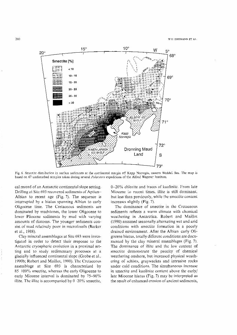
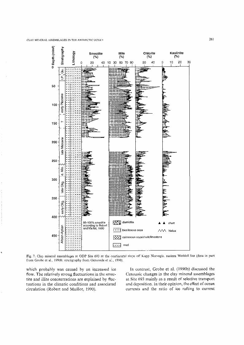
cal record of an Antarctic continental slope setting.Drilling at Site 693 recovered sediments of AptianAlbian to recent age (Fig. 7). The sequence isinterrupted by a hiatus spanning Albian to earlyOligocene time. The Cretaceous sediments aredominated by mud stones, the lower Oligocene tolower Pliocene sediments by mud with varyingamounts of diatoms. The younger sediments consist of mud relatively poor in microfossils (Barkeret aI., 1988).
Clay mineral assemblages at Site 693 were investigated in order to detect their response to theAntarctic cryospheric evolution in a proximal setting and to study sedimentary processes at aglacially influenced continental slope (Grobe et aI.,1990b; Robert and Maillot, 1990). The Cretaceousassemblage at Site 693 is characterized by85-100% smectite, whereas the early Oligocene toearly Miocene interval is dominated by 75-90%illite. The illite is accompanied by 0-20% smectite,
0-20% chlorite and traces of kaolinite. From lateMiocene to recent times, illite is still dominant,but less than previously, while the smectite contentincreases slightly (Fig. 7).
The dominance of smectite in the Cretaceoussediments reflects a warm climate with chemicalweathering in Antarctica. Robert and Maillot(1990) assumed seasonally alternating wet and aridconditions with smectite formation in a poorlydrained environment. After the Albian-early Oligocene hiatus, totally different conditions are documented by the clay mineral assemblages (Fig. 7).The dominance of illite and the low content ofsmectite demonstrate the paucity of chemicalweathering onshore, but increased physical weathering of schists, graywackes and intrusive rocksunder cold conditions. The simultaneous increasein smectite and kaolinite content above the early/late Miocene hiatus (Fig. 7) may be interpreted asthe result of enhanced erosion of ancient sediments,
CLAY MINERAL ASSEMBLAGES IN THE ANTARCTIC OCEAN 261
Kaolinite(%)
10 20 30o
Chlorite(%)
20 40
11 lite(%)
40 10 30 50 70 90
Smectite(%)
20
>Clo"0;:;::::i 0
vv:",::",::,"::-::-:vv;-::-::-::-:;-:vv:-::-:;-;:-:;-:vv;-:;-;;-:;-;;-:vv:-::-::-::-::-:vv:-::-::-::-::-:
vv:-::-::""::-::-:vv:-::-::-::-:;-:vv:-::-::-::-::-:vv:-::-::-::-::"":vv:-::-::-::-::-:vv:-::-::-::-::"':vv:-::-::-::-::-:vv:-::-::-::-:::-:vv:-::-::-::-::-:vv:-::-::-::-::-:vv:-::-::--::-::-:vv:-::-::-::-::-:vv:-::-::-::-::"":vv:-::-::-::-::-:vv:-::-::-::-::-:vv:-::-::-::-::-:vv:-::-::-::-::-:vv:-::-::-::-::"":vv:-::-::-::-::-:vv:-::-:::-::-::-:vv:-::-::-::-::-.vv:-::-::-::-::-:vV:",,::-::""'::"'::-:vv:-::-::-::-::-:vv:-::-::-::-::-:vv:-::-::-::-::-:vv:-::-::-::-::-:vv:-::-::-::-::"':vv:-::-::-::-::-:vv:-::-::-::-::-:vv:-::-::-::-:;-;
vv:-::-::-::-::-:vv:-::-::-::-::-:
Og> ::~~~~~
vv:-::-::-::-::-:<1> vv:-::-::",,::-::-:
IQ ::~~~~~vv:-::-::-::-::-:vv:-::-::-::-::-:vv:-::-::-::-::-:en vv:-::-::-::-,:-:
o ::~~~~~'>, v v:-::-::-::-::-:
re ::~~;~gvv:-::-::-::-::-:
Q)c:
200 Q)o0
~<ll§
250
0~ai
300
:;::- >-IJl .l:s:J e,g m
s:C,
C. :;Q) ...0 iii0
::ia0.:
50
Q)c:Q)o.2
100 a::>-1:«l<ll
150C'.
400 -11'.1\1'I-.-. .-' .
350
~<~A caicareous ooze/chalk/limestone
85·100% smectiteaccording to Robertand Maillot, 1990
I;':-t:~ diamictite
B biosiliceous ooze
~:"::":d mud......
'" '" chert
NV\ hiatus
Fig. 7. Clay mineral assemblages at ODP Site 693 at the continental slope off Kapp Norvegia, eastern Weddell Sea (data in partfrom Grobe et aI., 1990b; stratigraphy from Gersonde et aI., 1990).
which probably was caused by an increased iceflow. The relatively strong fluctuations in the smectite and illite concentrations are explained by fluctuations in the climatic conditions and associatedcirculation (Robert and Maillot, 1990).
In contrast, Grobe et al. (l990b) discussed theCenozoic changes in the clay mineral assemblagesat Site 693 mainly as a result of selective transportand deposition. In their opinion, the effect of oceancurrents and the ratio of ice rafting to current
262
transport controls the clay mineral distribution atthe Antarctic continental margin. Smectite as theusually smallest clay mineral remains longer insuspension and is therefore transported furtherthan other clay minerals. Smectite thus may serveas an indicator for a sedimentary environmentdominated by current-derived detritus (Grobeet aI., 1990b).
In late Quaternary sediments of the continentalslope off Kapp Norvegia smectite concentrationscorrelate inversely with the gravel content of thesediments and reveal maxima during glacial stages.While the gravel content of glaciomarine sedimentsnormally is a direct indicator for ice-rafting, thesmectite contents in this case can be used as anindicator for mainly hydrodynamic and gravitational sediment transport. During glacial maximathese transport processes dominated, whereas iceberg transport was reduced due to an almostpermanent sea-ice cover and a reduced massbudget of the Antarctic ice sheet. In contrast tosmectite, illite maxima occur during interglacialstages and may be the result of intensified icebergtransport (Grobe, 1986; Grobe et aI., 1990a,b;Grobe and Mackensen, in press).
The low smectite content in the surface sediments on the lower continental slope off KappNorvegia (Fig. 6) is compensated by illite concentrations generally exceeding 70%. High illite concentrations were also found on the continentalmargin further east of Kapp Norvegia (Elverhoiand Roaldset, 1983) and at the lower continentalslope adjacent to the Crary Trough (Fig. 5; Melles,1991). The source area for the illite has to besought on the East Antarctic craton. From there,the illite is transported southward along the continental margin probably by water or icebergs circulating clockwise with the Weddell Gyre.
Late Quaternary changes of the Weddell Seacirculation pattern are documented, for example,in a sediment core from Site PSI606 at the lowercontinental slope adjacent to the Crary Trough(Figs. 4 and 8). In spite of the limited stratigraphicinformation, it is obvious that the supply of claysized material by the Weddell Gyre, characterizedby high contents of illite, talc, amphibole andfeldspar, was repeatedly interrupted. In these times,the sediment was delivered from the south, either
W.U. EHRMANN ET AL.
by gravitational or hydrographic transport. Whichone of these processes was active, cannot be concluded from the clay mineral record alone. However, in combination with other sedimentparameters such as structures and textures, severalcoarse-grained gravitational deposits could beidentified (Fig. 8; Melles, 1991).
Examples from the deep sea off Antarctica
Deep-sea basins are the final sink for terrigenousmaterial delivered from the continental marginsby suspension, ice rafting, gravity flows etc. Asexamples for a deep-sea environment, the composite Sites 745 and 746 in the Australian-AntarcticBasin of the Indian Ocean and Site 694 in theWeddell Basin of the Atlantic Ocean are chosen(Table I; Fig. I). Both locations have approximately the same water depth and the same distanceto the Antarctic continent.
The upper Miocene to recent sediments at Sites745 and 746 are typically distal glaciomarine,mixed terrigenous and biosiliceous in composition,with two cyclically alternating facies. One facies ischaracterized by a relatively high biosiliceous production, low concentration of fine material and ahigh concentration of smectite. It represents conditions similar to that of the present-day. The otherfacies is more glacially influenced and is characterized by a large amount of terrigenous materialand a higher amount of detrital clay minerals(Ehrmann and Grobe, 1991; Ehrmann et aI., 1991).
The upper Miocene to recent clay mineral assemblage in the Australian-Antarctic Basin consistsof 10-50% smectite, 50-80% illite, 5-30% chloriteand 0-20% kaolinite (Fig. 9). All clay mineralsillustrate only minor significant long-term changes,but strong short-term changes caused by the cyclicsedimentation. The dominance of illite and chloriteover smectite and kaolinite is a result of physicalweathering of mainly igneous rocks on the nearbyEast Antarctic craton. The consistency of the claymineral assemblages since the late Miocene impliesrelatively stable weathering conditions on the continent with no major phases of warmer climate,which could allow chemical weathering. The clayminerals may have been derived directly as a resultof drifting icebergs. They might also have been

CLAY MINERAL ASSEMBLAGES IN THE ANTARCTIC OCEAN
-'"-; E11 lite Kaolinite Talc! Amphibole! Quartz!> u
Eo (%) (%) MoS2 MoS2 FeldsparCl ....
2 6 10 50 60 70 2 6 10 0.1 0.2 0.3 0.05 0.10 0.5 1.0 1.5
263
Fig. 8. Clay mineral assemblages at Site PS1606 at the lower continental slope of the southern Weddell Sea (data from Melles,1991). The location of the core is shown in Figs. 4 and 5. For legend see Fig. 3.
transported down the continental slope by gravitational processes, or might have been brought inby currents. Thus, the cyclically changing concentrations of the individual clay minerals are notthought to represent fluctuations in the intensityof glaciation. Rather they are due to complexinteractions of different transport mechanisms,which of course in turn may be controlled byclimate and glacial processes (Ehrmann andGrobe, 1991; Ehrmann et aI., 1991).
A different picture arises from the WeddellBasin. The middle Miocene to lower Pliocenesediments recovered at Site 694 in the WeddellBasin (Table I) are dominated by mud and mudstones typical for a detrital environment (Barkeret aI., 1988). In the lower Middle Miocene sediments, 40-45% illite and 25-45% chlorite dominate the clay mineral assemblages. From the upperMiddle Miocene to the lower Upper Miocene thecontents ofillite (25-55%), chlorite (15-35%) andsmectite (10-55%) are strongly fluctuating. Upcore
the smectite content increases to 25-70%, thechlorite content decreases to 0-20%, while theillite concentration remains constant at about25-50% (Robert and Maillot, 1990).
This clay mineral assemblage implies-by comparison with the assemblages at Site 693 and atSites 745 and 746-a West Antarctic source forat least parts of the assemblage. Thus, theenhanced smectite content since the late Miocenewas interpreted as evidence for erosion of ancientsedimentary rocks at the Antarctic margin. Themaximum smectite contents in sediments of lateEarly Pliocene age was thought to be indicativefor increased current activity (Robert and Maillot,1990). This period, however, was also characterizedby expanding glaciers and ice shelves after thepronounced early Pliocene deglaciation (Hodelland Kennett, 1986; Pickard et aI., 1988). The readvancing glaciers and ice shelves could incorporate large amounts of debris, which during thedeglaciation had been deposited in the coastal

264 W.U. EHRMANN ET AL.
~
>-Cii s:.Q Co >- Chlorite.§. E Cl Smectite 11 lite Kaolinites: .21 0 (%) (%) (%) (%)Q. -; '0
.r:C1l ... .... 20 40 60 30 50 70 90 10 20 30 0 10 20c en ::::i
0
10
20
30~ctlc: .........
40 n> .........ca::l
500
60
70
80
90 YVVV..................100 Q)
cCl>0
110 .2a::120 §
130
140
150Q)cCl>0
160 .2a::>-
170 ~Cl>
180
190.........
Cl>.........
CCl>
20000
~Cl>
210 .N ..................
Fig. 9. Clay mineral assemblages at ODP Site 745 in the Australian-Antarctic Basin (data from Ehrmann et aI., 1991). For legendsee Fig. 7.

CLAY MINERAL ASSEMBLAGES IN THE ANTARCTIC OCEAN
areas and on the continental shelf. Icebergs andocean currents could transport this material todistal regions and possibly could cause the maximum in smectite content.
Only a few studies on the clay sedimentology ofQuaternary deep-sea sediments from the AntarcticOcean exist to date. In sediments from the continental slope and abyssal plain of the westernWeddell Sea, Pudsey et al. (1988) distinguishedturbidites from hemipelagic muds, which may havesimilar textures and structures, by higher chloritecontents. This is an example how clay mineralscould be significant in identifying gravitationalsediment transport over distances of several hundred kilometers. An example for long-distancehydrographic transport and for the significance ofclay minerals for paleoceanographic interpretations was presented by Chamley (1975). Insediments of the last glacial stage from the VemaChannel (southwestern Atlantic Ocean) he foundhigh chlorite contents, which he could trace backto Antarctica. The chlorite probably was transported to this distal setting by the Antarctic Bottom Water.
Examples from submarine elevations in highlatitudes
Examples for submarine elevations come fromMaud Rise in the southern Atlantic Ocean (Figs.10 and 11) and from Kerguelen Plateau in thesouthern Indian Ocean (Fig. 12). Both structuresare separated from the Antarctic continent bydeep-water pathways preventing them from sediment inputs by slumpings or turbidites. The sediments at Sites 689 and 690 on Maud Rise and atSites 738 and 744 on Kerguelen Plateau (Table 1)are highly pelagic in character. The Cretaceous toMiocene sediments are dominated by nannofossiloozes, chalks and limestones, the latest Mioceneto recent sediments consist mainly of diatom oozes(Barker et al., 1988; Barron et al., 1989). Claymineral assemblages were investigated in order toreconstruct the paleoceanography of the AntarcticOcean and to reconstruct the Cenozoic paleoclimatic and glacial history of Antarctica (Robertand Maillot, 1990; Ehrmann, 1991; Ehrmann andMackensen, 1992).
265
Sites 689, 690, 738 and 744 show essentially thesame patterns in the clay mineral assemblages(Figs. 10-12). The clay fractions of the Cretaceous,Paleocene and Eocene sediments are dominatedby smectite with concentrations generally exceeding 90%. In the upper Eocene to lowermost Oligocene sediments, the smectite content decreases fromabout 90 to 70%. A distinct and sudden fall tominimum values of 10-20% occurs in lowermostOligocene sediments. Relatively low smectite concentrations dominate the remainder of the Oligocene sequence. In Miocene to recent sediments ofboth Maud Rise and Kerguelen Plateau valuesfluctuate around 40%. Illite shows a strong negative correlation with smectite. Chlorite and kaolinite appear at Kerguelen Plateau Sites 738 and 744and at Maud Rise Site 689 in significant amountssince the late Eocene (Figs. 10 and 12). In contrast,at Maud Rise Site 690 they also had a maximumfrom late Early Paleocene to early Eocene times(Fig. 11; cf. Robert and Maillot, 1990).
The distinct dominance of smectite over illiteand chlorite in Cretaceous to late Eocene sedimentsimplies relative stable conditions with chemicalweathering under humid conditions in Antarctica.Physical weathering processes played a limited roleonly. The late Early Paleocene to early Eocenekaolinite maximum at Site 690 may indicate thatthe climate was appropriate for kaolinite formationin parts of Antarctica (Robert and Maillot, 1990).However, because of the strong correlation withchlorite, it also could be caused by the erosion ofa kaolinite- and chlorite-bearing source. The lackof kaolinite at the nearby Site 689 suggests atransport of the kaolinite by a deep ocean currentwhich did not reach the shallower Site 689 (Robertand Maillot, 1990). The lack of kaolinite on Kerguelen Plateau could be due to a different composition of the source area. In late Eocene time, thechlorite and kaolinite contents increased at MaudRise Site 689 and on Kerguelen Plateau, with thekaolinite probably being recycled from old sedimentary rocks. This implies slightly enhancedphysical weathering, possibly as a result of theexpansion of glacierized areas in the inner part ofEast Antarctica. First signs of ice rafting werefound on Kergueleh Plateau and Maud Rise inmiddle Eocene sediments and indicate that some

lU;}UI!P;}S roqio Sn01;}UInU A:q poiroddns S! qJ!qM
'BJ!P1BlUV lSB3: U! UOPB!JBfB IBlU;}UPUOJ ]0 l;}SUO
oqi SB pcicrdrcnn uooq SBq lU<lA<l S!ql '(Z1-0 1'SJ5!d) lUnOUIB <lUIBS <lql U! P<lSB<llJU! SUO!lB1lU;}JUOJ
<lFIE <lql SB<ll<lqM 'A:IIBJPBUIBlPP;}SB<llJ;}P lU;}lUOJ
omoours oqi 'snql 'J5UP<lqlB<lM IBJ!SA:qd osuonn
]0 rrais cqi pUB J5UP<lqlB<lM IBJ!UI<lqJ ]0 <lSB<lJ
<lql U! pcnnsar H 'BW 6'~£ pUB £'9£ U<l<lMl<lq ';}UIP
<lU<lJOJ5HO lS<l!j1B;} <lql U! P<lqsHqBlS<l <llBUI!P l<lIOOJ
B 'S<lJ5BlqUI<lSSB IB1<lU!UI A:Bp <lql or J5U!P10JJV
'('1:66 I 'U<lSU<l:>PBW pUB UUBUI
-lq3:) oum lBql A:q lSBOJ <lql P;}qJB<ll pnq Si<l!JBIJ5
'L '~Id ;l;lS pU;l~;lI lOd 'UB;lJO JIlUBIlV urcqmos ;lql UI ;lSl'M pnBW uo 689 ;lllS dGO lB s;l~Blqw;lssB IBl;lU!W ABIJ '01 '~H
'1\1 El NN\llo\I~H3 'n'M
(0/0)aIIU!lo8)1
00&I
(\)III
~ t- OS?;s::IIIIIIsa.
~09~
"' Ot?;
O~?;
OO?;I
3cs:~ t- OS~m00(\)
~09~
Ot~
OU
OO~
OS
09
01'
O?;
0
~(Jl C.. III
::r ill~2- c:!:
0 IQ
'3~ ill'tl l:T::r VI-e ,;:,
99Z
Oc09
(%)amoaws
OO~Oc
(%)al!1II
09oO~
(0/0)al!JOlllO
Oco
:.rilli
O~Ocos

'L 'll!d cos pU;lll;lllOd '(01 'llId) 689 ;llIS oi poreduroo siucunpcs ;lU;l;)0t! AJlB;l oi ;lU;l;)O;lIBd ;llBI U!
iuaiuoo ;lllu!I0Blj l;llJllllJ ;llJl ;llON 'UB;l;)O ;)!luBIlV urcqmos ;llJl U! ;lSm pUBY\[ uo 069 ;lllS dao lB s;lllBlqUl;lssB IB1;lU!Ul ABI:::> '11 'll!d
OlE
-I m:-: III- :::>., '<
~ s:: I- OOE- III
III!!l.
=--+- 09l
~s::~ I- 09l;"'-
~ I- Ol'l~
iOll
i[m;.? I- OOliD00m16 I- 09~---
~j ~ I-09~---" -
ON
Ol~
OO~
09
09
Ol'
Ol
I0
08 OC: O~ 0 Oc: O~ 0 09 OC: OO~ 09 OC: C en Cl:T ~ m
III "'00 .. ..
(0/0) (%) (%) (0/0) 0' 10" :rIQ .. 3'at!U!lOB>I at\J0140 at!III am:>aws III'< "'0 C':::r s'<
L9Z NY3:JO :JI.l::nlY.lNY 3H.l NI S3DYlijW3SSY lY1I3NIW AY1:J

'L 'll!d oas pU;lll;lI 10d '(1661) UUBUllLJ::I UlOl] ;llB BlBp ;lLJ-L 'UB;lJO UBlpuIuroqmos ;lLJl ut nB;llBld u;lJdnlll;l){]O dn ul;lLJlnos ;lLJl UQ (MOJdq) 8EL ;ll!S pUB (;lAOqB) PPL ;llIS lB s;lllBlqUl;lsSB IB1;lU!Ul ABD '(;1 'll!d
OSP
0017
"""'X':::~m
OS£
00£
~fI'm8 I- OS1:<1l~
<1l
1,"'2,c.c.
~ I- OS~0s~<1l
;[,0<m os~
Ofi':,..
m0:-p
OS~
OO~
os
0.- !a c
08 OC O~ o oz O~ 0 09 GP oa o OO~ OB 09 017 OC 0 :TCl)
0 AI "'5l.5' g. :::T
(%) (%) (%) {%) ca AI 3'al!u!loe)l al!JOlll~ amu am:laws '< "tl eT:::T s'<
'1\1.13 NN\lJoIlllH3 'n'M 89(;

CLAY MINERAL ASSEMBLAGES IN THE ANTARCTIC OCEAN
parameters and the stable oxygen isotope record(Ehrmann and Mackensen, 1992).
In Oligocene to recent sediments, the clay minerals chlorite, illite, and kaolinite do not revealchanges in their concentrations patterns as distinctive as those close to the EocenejOligocene boundary indicating that the main shift in the weatheringregime had happened at that time. However, thisdoes not necessarily imply that also the mainpaleoclimatic shift had occurred at that time. Oncethe Antarctic continent was covered by ice anddominated by physical weathering processes, theclay mineral composition of the sediments wouldnot have changed significantly in response to afurther cooling event. The total amount of detritalclay minerals, however, may mirror such a climaticchange. Following the early Oligocene minimumin smectite content, the concentrations rose suddenly, but did not reach their former values (Figs.10-12). They indicate somewhat warmer conditions than in the early Oligocene, but colder conditions than in Eocene, Paleocene and Cretaceoustimes. A climatic optimum in the early Miocene isdocumented by maximum Neogene smectite concentrations on Kerguelen Plateau (Ehrmann,1991), but only slightly indicated on Maud Risedue to hiatuses.
The smectite concentrations on Maud Rise andon the southern Kerguelen Plateau reveal a strongnegative correlation with the oxygen isotope curvesfor planktonic and benthic foraminifers (Ehrmann,1991; Ehrmann and Mackensen, 1992). Thus,smectite concentrations show a decrease in themiddle Eocene, a marked drop shortly after theEocene/Oligocene boundary, an increase after theearly Oligocene minimum, relatively constantvalues until the early Miocene, a maximum in theearly Miocene, and a decreasing trend in youngersediments. The correlation between the oxygenisotope curves and the smectite content is strikingin Paleocene to early Miocene sediments, but lessconvincing in younger sediments. The weaker correlation in more- recent time is probably due tooceanographic changes. The opening of the DrakePassage as a deep-water pathway probably initiated the development of an intensified circumpolarAntarctic current and thus created a more complicated circulation pattern around Antarctica, which
269
also may have influenced the clay mineral distribution.
Discussion of the significance of clay minerals
Late Mesozoic and Cenozoic sediments
The examples presented in this paper give someidea about the significance of clay minerals indifferent settings for reconstructing paleoenvironment, glacial history and sedimentary processes.A basic problem which strongly affects the valueof clay minerals, but which has not been discussedso far, is the diagenetic alteration of the sediments.This may concern all drill sites penetrating deepbelow the seafloor into old sediments. Diagenesismay prohibit the disaggregation of the sedimentsduring sample preparation and also may complicate a reliable qualitative and especially a quantitative study of clay mineral assemblages. Diagenesisfurther may act by transforming clay minerals andthus disturbing or destroying their original paleoenvironmental implications.
Some diagenesis obviously took place at theinvestigated sites as indicated by the occurrence ofchert and clinoptilolite in Eocene and older sediments. However, we did not detect evidence thatdiagenesis affected the clay mineral assemblages.In contrast, at Site 737 near Kerguelen Island, thesediments and clay mineral assemblages werehighly altered, probably due to an enhanced heatflow; therefore the clay minerals of this site couldnot be interpreted in terms of paleoenvironmentand paleoclimate.
In late Mesozoic and Cenozoic sediments, thesignificance of clay mineral assemblages for reconstructing paleoenvironmental conditions stronglyvaries with the geological and morphological position of the sites under investigation. Close to thecontinent, on the Antarctic continental shelves, theglacial signals are very strong. However, the sedimentary record often is incomplete, becauseadvancing glaciers and ice shelves may removeparts of the sedimentary sequences and may causemajor reworking. In addition, in this part ofAntarctica, the paleoclimatic signal may be lesspronounced than the signal caused by sedimentaryprocesses and therefore may be obliterated. Thus,

270
the proximal settings are especially suitable forreconstructing sedimentary processes and for identifying source areas and changes in the transportregime.
At the Antarctic continental slope, sedimentredistribution by slumping, turbidity currents, conturites and bottom currents may play an importantrole and may control the clay mineral distribution.However, in the case of Site 693 at Kapp Norvegia,it has been shown that, although the sedimentredistribution may mask the paleoclimatic signal,it does not destroy it entirely. Both signals are ina delicate balance and each of them may dominateat certain times or at certain localities. In contrastto deposits both on the glacial continental shelfand in the deep sea, the sediments on the continental slope may contain calcareous foraminifera suitable for sediment dating and for stable isotopestudies.
The deep-sea basins represent distal settings andare large sinks for all terrigenous detritus deliveredfrom the continents. The clay minerals may haveexperienced a wide variety of different transportmedia and processes before they are deposited inthese basins. Therefore, they are important toolsfor deciphering and reconstructing sedimentaryprocesses, which in turn may allow to draw conclusions on the paleoclimate. The direct paleoclimaticsignificance of clay minerals increases with distanceto the continents, which is clearly shown by Quaternary sediments of the South Atlantic Ocean (R.Petschik, pers. commun., 1991).
A totally different picture arises from submarineelevations, such as the Kerguelen Plateau andMaud Rise, which cannot be reached by slumpsand turbidites. Detrital components are providedby suspension, wind or ice. The amount of clayminerals at those locations is normally very low« 5% of bulk sediment), but they store a wealthof paleoclimatic information. The presence of calcareous microfossils provides the possibility forexact biostratigraphic age determinations and fordirect comparisons with the information gainedfrom the oxygen isotope record. In the case ofMaud Rise, even detailed paleoceanographic information could be deduced from the clay mineralassemblages (Robert and Maillot, 1990).
The different examples presented in the previous
\V.U. EHRMANN ET AL.
chapters have emphasized the value of clay mineraldata for reconstructing paleoclimate through time.Especially the Cretaceous to Oligocene recordreflects pronounced changes in the weatheringregime on the Antarctic continent due to paleoclimatic changes. Thus the transition from a warmand humid climate with chemical weathering to acold and arid climate with physical weathering isdocumented at all sites that recovered sedimentsof the respective age. In the earliest Oligocene, acontinental East Antarctic glaciation established,and since then intense physical weathering, mainlyglacial scour, prevailed on the Antarctic continent.Since that time the climatic variations were notstrong enough to force a major change in theweathering regime, which could be detected easilyin the clay mineral assemblages of the marinesediments. At most locations the climatic signalswere therefore obliterated by hydrodynamic processes.
Quaternary sediments
In Quaternary sediments of the Antarctic Ocean,the amount of non-layered minerals is much higherthan in lower latitude clay fractions. Therefore thequantification of non-layered minerals may provide important informations. Although hydrolysiswas not an effective process in Antarctica duringthe Quaternary, some smectite and kaolinite wastransported from the continent to the sea. Thesetwo minerals were reworked from ancient rocksby physical processes. Hence, the mineral distribution in the clay fraction in the first instance dependson the nature of the source rocks.
On the Antarctic continental shelf, the terrigenous detritus supplied by the ice may be depositedas lodgement till beneath the grounded ice. Theclay mineral assemblage of such a sediment directlyreflects the composition of the source rocks. Theice-rafted debris also may accumulate in the glaciomarine environment through rainout from iceshelves or through melting of sediment-laden icebergs. In this case, the clay mineral assemblagesmay be affected by marine processes, which couldcause an enrichment or dilution of individualminerals. Additionally, previously deposited sediments can be redistributed by glacial, marine or

CLAY MINERAL ASSEMBLAGES IN THE ANTARCTIC OCEAN
gravitational processes. Thus, the mineral composition of the clay fraction of Quaternary sediments depends both on the source material andon the various transport processes. The determination of the clay mineral distribution, therefore, canbe an important tool for the reconstruction ofsource areas of the fine material as well as for thereconstruction of sedimentary processes. Becauseboth in turn depend on the climatic situation,Quaternary clay mineral records of the AntarcticOcean provide indirect information concerning theclimatic history of the southern high latitudes.
Most of the examples presented have illustratedthat often sedimentary processes can be identifiedby the clay composition only if combined withother sedimentological parameters such as sediment structure, texture or physical properties.Investigations of the clay mineral composition aremost promising in those areas, where changes insource regions with distinct petrographic differences are expected, and where distances from thesource region are low.
Conclusions
The value and shortcomings of clay mineralassemblages off Antarctica for reconstructing lateMesozoic to present-day paleoenvironmental conditions have been discussed and reviewed, basedon several selected examples coming from differentgeological and morphological settings. Some ofthe examples are presented in this study for thefirst time (Table I). The conclusions can be summarized as follows:
(I) Our proposed method of sample preparationand XRD-measurements with an internal MoS 2
standard proved to be successful in allowing us todetect changes in the concentration of individualclay minerals, independent from dilution effects byother minerals or amorphous components. Additionally, the method allows semi-quantitative interpretations of the distribution of non-layeredminerals and mineral groups in the < 2 urnfraction.
(2) Direct paleoclimatic information can beobtained from clay mineral assemblages of Cretaceous to Oligocene sediments. During this period,the transition from chemical weathering to physical
271
wheathering occurred on the Antarctic continentand is documented by a change from smectitedominated to illite- and chlorite-dominated claymineral assemblages.
(3) The best records of the weathering regimecan be obtained from submarine elevations. There,the sediments are not influenced by sediment redistribution such as sediment gravity transport, whichis common on continental slopes and in deep-seabasins. Generally, the stratigraphic record is morecomplete on submarine elevations than on continental shelves and slopes, where it is affected byhiatuses. Furthermore, good stratigraphic controlnormally allows exact dating of the discoveredchanges in paleoenvironment.
(4) Since early Oligocene time, when a continental East Antarctic glaciation had established,mainly physical weathering occurred and the primary clay mineral assemblages were dominated bydetrital clay minerals. Variations in the clay mineral records are predominantly due to differentsediment sources as a result of different glacial,hydro graphic or gravitational transport processes.Therefore, clay minerals are an important tool fordefining and interpreting sedimentary processes.
(5) The clay minerals may be affected by avariety of sedimentary processes, from which generally the dominating process is controlling theassemblage. The sedimentary processes depend onenvironmental conditions, such as the continentalice volume, the sea-ice coverage or the oceanographic circulation, which are directly linked toclimatic variations. Therefore, the clay mineralassemblages in Quaternary sediments provide nodirect but indirect paleoclimatic information.
Acknowledgements
We thank the officers and crews of PRV Polarstern and DV ID/DES Resolution for their competent help in collecting the samples. Samples fromMaud Rise kindly were provided by D.K. Futterer.The manuscript greatly benefitted from many critical comments of C. Robert and H. Chamley. Wealso thank R. Petschik and D. Warnke for furthercomments. R. Frohlking, A. Hienen and I. Engelbrecht are acknowledged for technical assistance.Some financial support for carrying out the labora-

272
tory work was provided by the DeutscheForschungsgemeinschaft. WUE further appreciatesthe financial support of a DAAD/NATO ResearchFellowship. This is contribution No. 512 of theAlfred Wegener Institute for Polar and MarineResearch, Bremerhaven.
References
Anderson, 1.B., Kurtz, D.D., Domack, E.W. and Balshaw,K.M., 1980. Glacial and glacial marine sediments of theAntarctic continental shelf. 1. Geol., 88: 399-414.
Anderson, 1.B., Brake, c., Domack, E., Myers, N. and Wright,R., 1983. Development of a polar glacial-marine sedimentation model from Antarctic Quaternary deposits and glaciological information. In: B.F. Molnia (Editor), Glacial-MarineSedimentation. Plenum, New York, pp. 265-300.
Bardin, V.I., 1982. Composition of East Antarctic morainesand some problems of Cenozoic history. In: C. Craddock(Editor), Antarctic Geoscience. Univ. Wisconsin Press, Madison, pp. 1069-1076.
Bardin, V.L, Bubnova, M.I. and Gerasimova, V.M., 1979. Clayminerals in unconsolidated deposits of the Prince CharlesMountains. Inf. Bull. SOy. Antarct. Exped., 71: 120-128.
Barker, P.F., Kennett, 1.P. et al., 1988. Proc. ODP, Init. Rep.,113, 785 pp.
Barrett, P.l. (Editor), 1989. Antarctic Cenozoic history fromthe CIROS-I drillhole, McMurdo Sound. DSIR Bull., 245,254 pp.
Barron, 1., Larsen, B. et al., 1989. Proc. ODP, Init. Rep., 119,942 pp.
Barron, 1.A., Baldauf, 1.G., Barrera, E., Caulet, l.-P., Huber,BT., Keating, B.H., Lazarus, D., Sakai, H., Thierstein, H.R.and Wei, W., 1991. Biochronologic and magnetochronologicsynthesis of Leg 119 sediments from the Kerguelen Plateauand Prydz Bay, Antarctica. Proc. ODP, Sci. Results, 119:813-847.
Biscaye, P.E., 1964. Distinction between kaolinite and chloritein recent sediments by X-ray diffraction. Am. Miner., 49:1281-1289.
Biscaye, P.E., 1965. Mineralogy and sedimentation of recentdeep-sea clay in the Atlantic Ocean and adjacent seas andoceans. Geol. Soc. Am. Bull., 76: 803-832.
Brindley, G.W. and Brown, G. (Editors), 1980. Crystal Structures of Clay Minerals and Their X-ray Identification. Miner.Soc. Monogr., 5, 495 pp.
Campbell, LB. and Claridge, G.G.c., 1987. Antarctica: Soils,weathering processes and environment. (Developments inSoil Sciences, 16.) Elsevier, Amsterdam, 368 pp.
Chamley, H., 1975. Influence des courants profonds au largedu Bresil sur la sedimentation argileuse recente. geme CongoInt. Sedimentol, (Nice.) 8: 13-17.
Chamley, H., 1979. North Atlantic clay sedimentation andpaleoenvironment since the Late lurassic. In: M. Talwani,W. Hay and W.B.F. Ryan (Editors), Deep Drilling Resultsin the Atlantic Ocean. M. Ewing Ser., Am. Geophys. Union,3: 342-361.
W.U. EHRMANN ET AL.
Chamley, H., 1989. Clay Sedimentology. Springer, Berlin,623 pp.
Chamley, H., Maillot, H., Duee, G. and Robert, c., 1984.Paleoenvironmental history of Walvis Ridge at the Cretaceous-Tertiary transition, from mineralogical and geochemical investigations. Init. Rep. DSDP, 74: 685-695.
Claridge, G.G.c., 1965. The clay mineralogy and chemistry ofsome soils from the Ross dependency, Antarctica. N.Z.1. Geol. Geophys., 3: 186-200.
Claridge, G.G.c. and Campbell, 1.B., 1989. Clay mineralogy.In: P.l. Barrett (Editor), Antarctic Cenozoic History fromthe CIROS-I Drillhole, McMurdo Sound. DSIR Bull., 245:185-193.
Craddock, c., 1982. Geological map of Antarctica. In: C.Craddock, (Editor), Antarctic Geoscience. Univ. WisconsinPress, Madison.
Darby, D.A., 1975. Kaolinite and other clay minerals in ArcticOcean sediments. 1. Sediment. Petrol., 45: 272-279.
Domack, E.W., Anderson, 1.B. and Kurtz, DD., 1980. Clastshape as an indicator of transport and depositional mechanisms in glacial marine sediments: George V continentalshelf, Antarctica. 1. Sediment. Petrol., 50: 813-820.
Ehrmann, W.U., 1991. Implications of sediment compositionon the southern Kerguelen Plateau for paleoclimate anddepositional environment. Proc. ODP, Sci. Results, 119:185-210.
Ehrmann, W.u. and Grobe, H., 1991. Cyclic sedimentation atSites 745 and 746. Proc. ODP, Sci. Results, 119: 225-237.
Ehrmann, W.u. and Mackensen, A., 1992. Sedimentologicalevidence for the formation of an East Antarctic ice sheet inEocene/Oligocene time. Palaeogeogr., Palaeoclimatol.,Palaeoecol., 93: 85-120.
Ehrmann, W.U., Grobe, H. and Fiitterer, D.K., 1991. LateMiocene to Holocene glacial history of East Antarcticarevealed by sediments from Sites 745 and 746. Proc. ODP,Sci. Results, 119: 239-260.
Elverhoi, A. and Roaldset, E., 1983. Glaciomarine sedimentsand suspended particulate matter, Weddell Sea Shelf, Antarctica. Polar Res., I: 1-21.
Fiitterer, D.K. and Melles, M., 1990. Sediment patterns in thesouthern Weddell Sea: Filchner Shelf and Filchner Depression. In: U. Bleil and 1. Thiede (Editors), Geological Historyof Polar Oceans: Arctic Versus Antarctic. (NATO/ASI Ser.C, 308.) Kluwer, Dordrecht, pp. 381-401.
Gersonde, R., Abelmann, A., Burckle, L.H., Hamilton, N.,Lazarus, D., McCartney, K., O'Brian, P., Spieli, V. andWise, S.W., lr., 1990. Biostratigraphic synthesis of Neogenesiliceous microfossils from the Antarctic Ocean, ODP Leg113 (Weddell Sea). Proc. ODP, Sci. Results, 113: 915-936.
Griffin, 1.1., Windom, H. and Goldberg, E.D., 1968. Thedistribution of clay minerals in the World Ocean. Deep-SeaRes., 15: 433-459.
Grobe, H., 1986. Spatpleistozane Sedimentationsprozesse amantarktischen Kontinentalhang vor Kapp Norvegia, ostlicheWeddell See. (Rep. Polar Res., 27.) Alfred Wegener Inst.,Bremerhaven, 128 pp.
Grobe, H. and Mackensen, A., in press. Late Quaternaryclimatic cycles as recorded in sediments from the Antarcticcontinental margin. In: D. Warnke (Editor), Neogene Antarc-
CLAY MINERAL ASSEMBLAGES IN THE ANTARCTIC OCEAN
tic Glacial Evolution. Am. Geophys. Union, Antarct. Res.Ser.
Grobe, H., Mackensen, A., Hubberten, H.-W., Spiels, V. andFiitterer, D.K., 1990a. Stable isotope record and late Quaternary sedimentation rates at the Antarctic continental margin.In: U. Bleil and J. Thiede (Editors), Geological History ofPolar Oceans: Arctic Versus Antarctic. (NATO/ASI Ser. C,308.) Kluwer, Dortrecht, pp. 539-572.
Grobe, H., Futterer, D.K. and Spiels, V., 1990b. Oligocene toQuaternary sedimentation processes on the Antarctic continental margin, ODP Leg 113, Site 693. Proc. ODP, Sci.Results, 113: 121-131.
Hambrey, MJ., Ehrrnann, W.U. and Larsen, B., 1991. Cenozoic glacial record of the Prydz Bay continental shelf, EastAntarctica. Proc. ODP, Sci. Results, 119: 77-132.
Hodell, D.A. and Kennett, J.P., 1986. Late Miocene-earlyPliocene stratigraphy and pale oceanography of the SouthAtlantic and Southwest Pacific oceans: A synthesis. Paleoceanography, I: 285-311.
Juckes, L.M., 1968. The geology of Mannefallknausane andparts of Vestfjella, Dronning Maud Land. Br. Antarct. Surv.Bull., 18: 65-78.
Juckes, L.M., 1972. The geology of north-eastern Heimefrontfjella, Dronning Maud Land. Br. Antarct. Surv. Sci. Rep.,65: 1-44.
Kastner, M., 1981. Authigenic silicates in deep-sea sediments:Formation and diagenesis. In: C. Emiliani (Editor), The Sea.Wiley, New York, 7, pp. 915-980.
Lange, H., 1982. Distribution of chlorite and kaolinite ineastern Atlantic sediments off North Africa. Sedimentology,29: 427-432.
Lisitzin, A.P., 1972. Sedimentation in the World Ocean. SEPMSpec. Publ., 17,218 pp.
McManus, D.A., 1991. Suggestions for authors whose manuscripts include quantitative clay mineral analysis by X-raydiffraction. Mar. Geo!., 98: 1-5.
Melles, M., 1987. Sedimentation in der Filchner-Depression,sudostlicher Weddellmeer-Schelf, Antarktis. Dipl, Thesis,Univ. Gottingen, 180 pp. (unpub!.).
Melles, M., 1991. Palaoglaziologie und Palaozeanographie imSpatquartar am Kontinentalrand des sudlichen Weddellmeeres, Antarktis. (Rep. Polar Res., 81.) Alfred WegenerInst., Brernerhaven, 190 pp.
Naidu, A.S., Burrell, D.C. and Hood, D.W., 1nl. Clay mineralcomposition and geological significance of some BeaufortSea sediments. J. Sediment. Petrol., 41: 691-694.
Olaussen, S., 1985. Sedimentological research in northwesternpart of Dronning Maud Land. Rep. Norw. Ant. Res. Exp.1984/85, Nor. Polarinst. Rapportser., 22: 75-82.
Oskierski, W., 1988. Verteilung und Herkunft glazial-marinerGerolle am Antarktischen Kontinentalrand des ostlichen
273
Weddellmeeres. (Rep. Polar Res., 47.) Alfred Wegener Inst.,Bremerhaven, 167 pp.
Peters, M., 1989. Die Vulkanite im westlichen und mittlerenNeuschwabenland, Vestfjella und Ahlmannryggen, Antarktika. Petrographie, Geochemie, Geochronologie, Palaomagnetismus, geotektonische Implikationen. (Rep. Polar Res.,61.) Alfred Wegener Inst., Bremerhaven, 186 pp.
Pickard, J., Adamson, D.A., Harwood, D.M., Miller, G.H.,Quilty, P.G. and Dell, R.K., 1988. Early Pliocene marinesediments, coastline, and climate of East Antarctica. Geology, 16: 158-161.
Piper, DJ.W. and Brisco, C.D., 1975. Deep-water continentalmargin sedimentation, DSDP leg 28, Antarctica. Init. Rep.DSDP, 28: 727-755.
Piper, DJ.W. and Pe, G.G., 1977. Cenozoic clay mineralogyfrom D.S.D.P. holes on the continental margin of the Australian-New Zealand sector of Antarctica. N.Z. J. Geo!. Geophys., 20: 905-917.
Piper, DJ.W. and Slatt, R.M., 1977. Late Quaternary claymineral distribution on the eastern continental margin ofCanada. Geol. Soc. Am. Bull., 88: 31-34.
Pudsey, CJ., Barker, P.F. and Hamilton, N., 1988. WeddellSea abyssal sediments: A record of Antarctic Bottom Waterflow. Mar. Geol., 81: 289-314.
Ravich, M.G. and Fedorov, L.V., 1982. Geologic structure ofMacRobertson Land and Princess Elizabeth Land, EastAntarctica. In: C. Craddock (Editor), Antarctic Geoscience.Univ. Wisconsin Press, Madison, pp. 499-504.
Robert, C. and Maillot, H., 1990. Paleoenvironments in theWeddell Sea area and Antarctic climates, as deduced fromclay mineral associations and geochemical data, ODP Leg113. Proc. ODP, Sci. Results, 113: 51-70.
Stephenson, P.J., 1966. Geology. I. Theron Mountains, Shackleton Range and Whichaway Nunataks (with a section onpalaeomagnetism of the dolerite intrusions by DJ. Blundell).Sci. Rep. Transantarct. Exped., 8, 79 pp.
Trail, D.S. and McLeod, I.R., 1969. Geology of the LambertGlacier region. In: C. Craddock (Editor), Geologic Maps ofAntarctica. Antarctic Map Folio Ser., Folio 12, Plate XI.Am. Geogr. Soc., New York.
Weber, W., 1982. Beitrag zur Geologie des Pensacola-Gebirges(Antarctica). Freiberger Forschungsh., Leipzig, C371: 41-96.
Wessel, M., 1989. Sedimentationsprozesse an der FilchnerSchelfeiskante, Antarktis. Dip!. Thesis, Univ. Gottingen,177 pp. (unpub!.).
Windom, H.L., 1976. Lithogenous material in marine sediments. In: J.P. Riley and R. Chester (Editors), ChemicalOceanography. Academic Press, New York, 5, pp. 103-135.
Wolmarans, L.G. and Kent, L.E., 1982. Geological investigations in western Dronning Maud Land, Antarctica-a synthesis. S. Afr. J. Antarct. Res., Suppl., 2, 93 pp.