Sign inventory makes it easier to meet the...
12
THE DEADLINE for local governments to adopt a plan and method for maintaining minimum levels of sign retroreflectivity as spelled out in the latest MUTCD (Manual on Uniform Traffic Control Devices) is coming up in January 2012. It is a prime opportunity to create a well-organized inventory of traffic signs, something the Federal Highway Administration has recommended for more than 40 years as an efficient way for local road officials to manage signs and meet all MUTCD requirements. An up-to-date inventory also is useful for planning, budgeting and reducing liability exposure. Various presenters discussed the subject of sign inventories, manual or computerized, at a Transportation Information Center workshop on Highway Safety last fall and a Sign Retroreflectivity program the year before. While attending those sessions, Steve Bezemek from the Town of Necedah and Jeff Peterson from the Town of Westboro each began to formulate plans to find an inventory tool to fit their sign management needs. From zero to something Besides the 2012 date for having a sign management or assessment method, the MUTCD requires that governments meet minimum retroreflectivity requirements for regulatory, warning and other signs by January 2015 and all street name and overhead guide signs by January 2018. A sign inventory that http: //tic.engr.wisc.edu WISCONSIN TRANSPORTATION INFORMATION CENTER – LTAP at the University of Wisconsin–Madison The MUTCD deadlines are a prime opportunity to create a well- organized inventory of traffic signs. Sign inventory makes it easier to meet the MUTCD Continues on page 8 SPRING 2011 is current and updatable makes it easier to meet these deadlines and manage limited resources wisely. Software tools on the market include SignView by Iowa-based Cartegraph, SignMaster by Master- mind Systems of Elmore, Ohio, and Simple Signs by Minnesota-based Rowekamp Associates. These and other sign inventory systems offer a range of features that state and local governments can evaluate to find one that fits their sign management needs and budgets. Necedah’s Bezemek says when he started as Road Supervisor with the Juneau County community four years ago, there was nothing on paper or anywhere else about the status of sign replacements or maintenance. However, of the Taking exact measurements of sign retroreflectivity using a retro- reflectometer like the tool pictured is one method local governments can implement to maintain MUTCD minimums. The deadline for implementing a management or assessment method is January 2012. more than 700 signs his agency maintains on 116 miles of local roads, he found a lot that needed attention. This fact combined with the impending MUTCD deadlines convinced him the time was right to develop an inventory. Bezemek already ran his opera- tion—a mix of three full- and part-time people—from a laptop in his truck. He keeps track of road maintenance, connects to the Diggers Hotline and records pavement ratings data in WISLR (Wisconsin Information System for Local Roads) from his mobile office. The prospect of having access to a current database of traffic signs from there fit his idea of being efficient. “Do it once, do it right.” CREDIT: TAPCO
Transcript of Sign inventory makes it easier to meet the...

THE DEADLINE for local governments to adopt a plan andmethod for maintaining minimumlevels of sign retroreflectivity asspelled out in the latest MUTCD(Manual on Uniform Traffic ControlDevices) is coming up in January2012. It is a prime opportunity tocreate a well-organized inventory of traffic signs, something theFederal Highway Administration has recommended for more than40 years as an efficient way forlocal road officials to manage signsand meet all MUTCD requirements.An up-to-date inventory also is useful for planning, budgeting andreducing liability exposure.
Various presenters discussedthe subject of sign inventories,manual or computerized, at a Transporta tion InformationCenter workshop on HighwaySafety last fall and a Sign Retro reflectivity program theyear before. While attendingthose sessions, Steve Bezemekfrom the Town of Necedah and Jeff Peterson from theTown of West boro each beganto formulate plans to find aninventory tool to fit their sign management needs.
From zero to something
Besides the 2012 date for having asign management or assessmentmethod, the MUTCD requires that governments meet minimumretroreflectivity requirements forregulatory, warning and other signs by January 2015 and all streetname and overhead guide signs byJanuary 2018. A sign inventory that
http://tic.engr.wisc.edu
WISCONSIN TRANSPORTATION INFORMATION CENTER – LTAP at the Univers i ty of Wiscons in–Madison
The MUTCDdeadlines are a primeopportunity tocreate a well-organizedinventory oftraffic signs.
Sign inventory makes it easier to meet the MUTCD
Continues on page 8
SPRING 2011
is current and updatable makes iteasier to meet these deadlines andmanage limited resources wisely.
Software tools on the marketinclude SignView by Iowa-basedCartegraph, SignMaster by Master -mind Systems of Elmore, Ohio, andSimple Signs by Minnesota-basedRowekamp Associates. These andother sign inventory systems offer a range of features that state andlocal governments can evaluate to find one that fits their sign management needs and budgets.
Necedah’s Bezemek says when he started as Road Supervisor withthe Juneau County community four years ago, there was nothingon paper or anywhere else aboutthe status of sign replacements ormaintenance. However, of the
Taking exact measurements of sign retroreflectivity using a retro-reflecto meter like the tool pictured is one method local governmentscan implement to maintain MUTCD minimums. The deadline for imple menting a management or assessment method is January 2012.
more than 700 signs his agencymaintains on 116 miles of localroads, he found a lot that neededattention. This fact combined withthe impending MUTCD deadlines convinced him the time was rightto develop an inventory.
Bezemek already ran his opera-tion—a mix of three full- and part-time people—from a laptop in his truck. He keeps track of road maintenance, connects to the Diggers Hotline and recordspavement ratings data in WISLR(Wisconsin Information System forLocal Roads) from his mobile office.The prospect of having access to a current database of traffic signsfrom there fit his idea of being efficient. “Do it once, do it right.”
CRE
DIT: T
APC
O

SUMMER 2010http://tic.engr.wisc.edu
Wisconsin TICUW–Madison
SPRING
2011
C
2
Streetlighting with LEDs
STREETLIGHTS make roadwayssafer and more navigable afterdark for drivers, bicyclists andpedestrians. They light the way,discourage crime, and improvequality of life for residents andbusinesses.
Operating and maintainingstreetlights, however, takes abite out of municipal budgets.Technologies like LED (light-emitting diode) streetlights arean example of an alternativedesigned to lower costs andsave energy. But if LEDs reducelighting levels, the change canhave a negative impact on safety. As the technology comesinto the mainstream for outdoorlighting, local governmentsneed to consider whether or notto incorporate LEDs into theirown streetlighting plans.
They can learn from the experience of public agencies inWisconsin and across the coun-try doing replacements with LEDfixtures right now. Pilot studiesby federal agencies and privategroups give state and local gov-ernments the chance to evalu-ate the technology’s potentialand its limitations.
Understanding LEDs
LED technology uses direct currentto activate a solid-state lightingdevice. In streetlighting and otherapplications, the technology’sadvantages can include energysavings, longer life, instant startand restart, and greater control of fixture operation.
What kind of energy savings doLEDs produce? And what kind oflight do they give? The industryclaims a 40 to 80 percent decreasein energy use with LEDs. But someof those savings come from reduc-ing the light (lumens) that shinesonto the pavement. Local agenciesshould evaluate where it makessense to install LEDs, how to spacethe lights for optimal illumination,and determine the wattage ordrive current needed to achieve it.Some roads or intersections mightrequire higher light levels than
LEDs supply. There are energy conservation groups and manufac-turers that recommend lower light-ing levels based on research thatshows the white light produced byLED fixtures improves the ability toaccomplish certain tasks. But it isunclear if this research applies tostreetlighting applications. Currentstreetlighting design standardsrequire the same level of light onthe pavement regardless of thelight source.
LEDs are new enough that thereis limited field data on how longthey last, but the current genera-tion of LED luminaires—a completelighting unit—is rated at 10 to 16years. If field experience matchesthe ratings, this might translateinto reduced maintenance costscompared with the typical three-to-four year relamping cycle for
As the technologycomes into themainstream foroutdoor lighting, localgovernments need toconsider whether ornot to incorporateLEDs into their ownstreetlighting plans.
conventional streetlights. Agenciesalso need to calculate the costs ofmaintaining light output, fromperiodic cleaning of the luminaireto component replacement.
The initial investment in LED fix-tures is higher than what highwayand street departments generallyspend on replacements. Recentpublic bid tabulations in Wisconsinshow LED costs of $325 to $425per luminaire versus $80 to $100per luminaire for typical high-pressure sodium (HPS) cobra head-type streetlights. That gap has narrowed with growth in the mar-ket for LEDs. Experts predict LEDstreetlight costs will decrease 5 to15 percent per year going forward.
Payback on the investment variesaccording to local energy costs andwhether the new luminaries arerequired to provide the same
Contacts
Ron BursekCity of [email protected]
Katie JelacicCity of [email protected]
Ben JordanTransportation [email protected]
Two images from a streetlighting installation on 75th Street in Kenosha—one of three projects in recent years where the city applied new lightingtechnology by retrofitting or replacing streetlights with LED luminaires.

http://tic.engr.wisc.edu
C
SPRING
2011 Wisconsin TICUW–Madison
3
amount of light as the existing system. In recent reports ondemonstration projects funded bythe U.S. Department of Energy(DOE), communities saw a 10-to-12 year payback. Other agenciesreported a return in as few asseven years.
Research the options
In Wisconsin, Waukesha andKenosha are among severalcities that took advantage ofARRA (American Recovery and Reinvestment Act) grantsdistributed through DOE forsome or all of their recent light-ing projects that includedinstalling LED fixtures. Outside funding makes it easier
to consider replacing or retrofittingstreetlights with LEDs despite thelong payback period. Reports ofrapid advances in the technologyand its long-term energy- and cost-saving potential make it of interestto municipalities budgeting futurestreetlighting replacements.The City of Waukesha adopted
an energy efficiency plan four yearsago, says Katie Jelacic, a projectengineer with the city’s departmentof public works. The plan includedretrofitting all existing HPS street-lights with either LED or inductionfixtures. Thanks to a $657,400ARRA grant, the city embarked in January 2010 on a project toreplace the city’s streetlights withnewer technology.Jelacic led the project which
included testing the performanceof products from 14 vendors. “We needed to see the technologyin action to decide what wouldwork for us,” she explains aboutthe process that helped the citynarrow the field of viable options. Each company loaned two to
four fixtures and all necessaryequipment to mount them onexisting poles at no cost. Over sixmonths, Waukesha evaluated thefixtures for energy efficiency, lightdistribution, ease of retrofit, priceand the response from the public. In a June 2010 report to the
DOE, Jelacic described the projectteam taking readings with a light
LED ChecklistMany companies are vying for ashare of the growing LED market.Local governments exploring thetechnology for current or futureprojects should look for vendorswith expertise in the technology.This checklist highlights key issuesinvolved in selecting a product thatwill perform well.
� Look for manufacturers with LED and streetlighting luminaire experience.
� Ask the manufacturer for acertified luminaire photometricreport (per IESNA LM-79) froman approved lab for eachluminaire under consideration.
� Obtain lumen depreciation datafor a LED luminaire supported by the LED chip manufacturer’sIESNA LM-80 test data.
� Learn about LED luminaires anddrive current: Increased drivecurrent produces greater lightoutput but can reduce LED lifeand increase energy use.
� Test LED luminaires with differentcorrected color temperatures(CCT) and get public feedbackon preferred light color.
� Look for luminaires with a vibration rating testedaccording to ANSI C136.31requirements.
� Look for Ingress Protection(IP) Code designations thatrate how a fixture holds upagainst exposure to water,dust and other materials that can enter the luminaireassembly.
� Test sample luminaires for ease of installation,maintenance and repair.
� Look for LED luminaires withan extended warranty andcheck manufacturer’s abilityto stand behind it. A five-year warranty is common for LED streetlights butlonger warranties might beavailable. Understand whatthe warranty covers, whatconstitutes failure and ifthere are any exclusions.
Streetlightingsystems that workwell improvevisibility withoutproducing excessglare, skyglow orlight trespass ontoadjacent properties.
Resources
www1.eere.energy.gov/buildings/ssl/consortium.htmlDOE’s Municipal Solid-StateStreet Lighting Consortiumshares LED streetlightingtechnical information and bestpractices. Free membership formunicipalities.
www.clintonfoundation.org/what-we-do/clinton-climate-initiative/cities/lightingLink on Clinton Foundation siteto recent white paper aboutthe cost and climate impact ofstreetlighting retrofit projects.
www.lrc.rpi.edu/programs/nlpip/publicationResults.asp?type=1Two Lighting Research Centerreports compare conventionaland LED continuousstreetlighting systems.
www.news.pitt.edu/news/led-streetlights-best-buy-cities-pitt-researchers-report-first-cradle-grave-comparison-common-aUniversity of Pittsburghresearch paper on theenvironmental impact of LEDtechnology for streetlighting.
www.ul.com/global/eng/pages/offerings/services/hazardouslocations/ref/ingressIngress Protection Codedesignations on the website of UL, global safety sciencecompany.
Continues on page 4
Harbor Park in Kenosha as seen from the air, showing newlyinstalled LED streetlights that line a boulevard street. The whiterlight produced by the LEDs contrasts with the yellow glow ofconventional streetlights on adjacent streets.

SUMMER 2010 http://tic.engr.wisc.eduhttp://tic.engr.wisc.edu
Wisconsin TICUW–Madison
SPRING
2011
SPRING 2011 CROSSROADS
SPRING
2011 Wisconsin TICUW–Madison
4
The department undertook its first upgrade on a road reconstruction project in 2008.They installed LED cobra headluminaires on existing poles andmodifed the arm to extend anadditional eight feet over theroadway.
“That project turned out fairlywell, but we thought we couldimprove on having to work withthe existing pattern of poles,”Bursek says.
They got the chance a yearlater on a mile of street wherecity engineers redesigned thestreetlighting based on the capabilities of the new lightingtechnology. Being able to position light poles in the bestlocation for LED illumination produced good results.
Cost per luminaire was $800installed for the cobra head fix-tures on these two projects, fourtimes the city’s previous cost of$200 plus labor for the old sodi-um lights. What Bursek expectsto see are lower labor costs forLED light sources in fixtures last-ing up to 16 years versus lampsin conventional streetlights thatlast three or four years.
A third project involved retro-fitting decorative Acorn fixturesin the downtown area with LEDsthat match the historic look ofexisting lights. Partially fundedthrough an ARRA grant, it is ademonstration project evaluatingthe energy efficiency of LEDs.Kenosha contributed $400,000to the project’s $1.3 million totalcost. According to Bursek, thelights they chose are similar incost to conventional replace-ments of this particular fixturebut with an estimated 16-yearlife cycle. While they expect 35 to 40 percent in energy savings, he notes the greatestprojected savings will be inreplacement costs.
Bursek says the city studied the issue of upgrading the Acorn lights for a year, doing the analysis necessary to find thebest replacements. Part of hisprocess was to negotiate a long-term warranty since there is no
track record for the technologyor the products. Based on average city use of 4,200 hoursper year for the luminaires, thewarranty covers 70,000 totalhours in operation at no lessthan 70 percent of lumens emitted when new. It also coversany components that fail duringthat same period.
“Making sure we did theresearch was important,” henotes. “So even ahead of thecurve on adopting LEDs, I feelconfident we’re going in theright direction.”
Use standard as guide
It is a good idea to design street-lighting to a recognized standardwhen considering LEDs for a retro-fit or as part of a reconstructionproject. Systems that work wellimprove visibility without produc-ing excess glare, skyglow or lighttrespass onto adjacent properties.
The American National StandardPractice for Roadway Lighting,known as IES/ANSI RP-8, covers the standard practice for design ofstreetlights on roads with continu-ous lighting systems. RP-8 is pro-duced by the IES (IlluminatingEngineering Society) and approvedby the ANSI (American NationalStandards Institute).
For state highways, the AASHTO(American Association of StateHighway and TransportationOfficials) Roadway Lighting DesignGuide specifies minimum levels oflighting quality and identifies road-ways where lighting is warranted.State or local policies that establishpole placement and the spacing ofstreetlights for non-continuouslighting also may apply.
Does it pencil out?
There is a lot of information todigest when weighing the prosand cons of installing LED street-lights. Recent reports from theLighting Research Center atRensselaer Polytechnic Instituteindicate minimal energy savings forLED continuous lighting systemsdesigned to current recommendedpractices on collector and arterial
meter to determine light distribu-tion at street level and measuringthe amount of energy used at eachluminaire to compare the energyconsumption of HPS and LED orinduction fixtures. The new fixturesmeet the city’s minimum criteria for light output. Estimating theaverage life of the newer fixturesat more than 60,000 hours forboth lamp and driver versus18,000 hours for the HPS lampand 60,000 hours for the ballast,she figured the city would seemeasurable savings with the newstreetlights.
They also anticipate saving onmaintenance costs. “I hope to goas long as 10 years before needingto replace most of these lights.”She estimates payback on theupgrade in approximately seven to eight years.
Changing streetlights alreadywas part of an approved multi-yearplan in Waukesha. But when thecity secured the grant, publicworks was able to accelerate itsreplacement program rather thando it piecemeal. Earlier this year,they completed retrofitting all1,200 of the city’s streetlights withone of the LED cobra head lumi-naires tested during the pilot at acost of $365 per fixture plus labor.
Reflecting on the project, Jelacicsays researching their options wasa real help in identifying whichproduct best met Waukesha’s goal of going green in a way thatbenefits the community.
Project-to-projectcomparison
Several road projects over the lastthree years gave Kenosha’s Directorof Public Works Ron Bursek thechance to install LED streetlights in several retrofitting projects andone that involved a redesign. “Westarted looking at this technologyseven or eight years ago and I’veseen major improvements everyyear in cost and performance,” henotes, adding that while the city’sprimary reason for the change was to reduce maintenance costs,reducing the impact on the envi-ronment also played a role.
Streetlighting with LEDs
from page 3
Payback on theinvestment variesaccording to localenergy costs andwhether the newluminaries arerequired to providethe same amountof light as theexisting system.
Evaluate where it makessense to install LEDs andhow to space light polesfor optimal illumination.

http://tic.engr.wisc.eduhttp://tic.engr.wisc.edu
Wisconsin TICUW–Madison
SPRING
2011
SPRING 2011 CROSSROADS
SPRING
2011 Wisconsin TICUW–Madison
5
streets. Researchers found that inmost instances, LED streetlightsthat meet RP-8 requirements forcontinuous lighting are moreexpensive to own and operateover the life cycle than conven-tional lighting. Intermittent light-ing systems and other installationswith less stringent requirementsmay produce different results.
Ben Jordan, Program Directorwith the Transportation Informa -tion Center who also teaches acontinuing education course on effective roadway lighting, recommends that local govern-ments look closely at the factorsthat influence their own situationbut then go a bit further.
“Determine the lighting design criteria that apply to a specificproject and use lighting designsoftware to get the results thatmeet the criteria,” he suggests.“Even a basic design gives agencyofficials a foundation for makinga clear comparison of their LEDand conventional options.” Low-or no-cost software from lightingmanufacturers can make it easierto look at costs for initial pur-chase, installation, maintenanceand energy consumption.
Lower environmental impact is another reason to consider up -grading to LEDs. Savings in thisarea are harder to calculate, butworth exploring to better under-stand the long-term implications.
LED futures
Advances in product design andgrowing competition in the streetlighting market means LED technology is worth keeping inmind for replacement or redesign projects. The numbers may not“pencil out” this year, but theymight make sense in subsequentyears. Local governments willbenefit by reviewing informationabout LED streetlights from credible sources and studying theresults reported by communitiesin Wisconsin who are earlyadopters of the new lightingtechnology. �
LOCAL GOVERNMENT officials can view and map crashdata on the roads they managethanks to collaboration betweenthe Wisconsin Transportation Infor -mation Center (TIC) and the TrafficOperations and Safety (TOPS)Laboratory�at the UW-Madison.The web-based Community Mapsprogram provides local agencieswith the facts they need to keeproads safe and traffic moving.
Joni Graves, who directs theproject for TIC and works withdeveloper Steven Parker of theTOPS Lab, says it is the aim of Commu nity Maps to give localroad officials, law enforcement andcounty Traffic Safety Commissions(TSCs) a powerful resource to helpthem identify and prioritize safetyimprove ments. Users can accessdata on fatal traffic accidents from2001 to the present.
The site uses the familiar GoogleMaps to create an online tool available for viewing by the public.General users can search for resultsin one or more counties and limittheir search by date range, crashseverity or manner of collision.They also can identify two pointson a segment of road or draw a“boundary box” around an area of interest.
How it works
Many local governments will benefit from the advanced searchfunctions of Community Maps,
which requires login account accessto the WisTransPortal. Advancedusers can create spot maps anddownload data from their searchresults. The “admin” feature allows registered users to map and manage their crash data.
To maintain the map of fatalcrash locations, Graves updates thesite with preliminary data from theDaily Fatality Report (DFR). Thenshe seeks information directly fromlocal law enforcement to augmentthe report and make the map time-lier. “We use a simple, web-basedinterface to request additionalinformation, an approach I hopebuilds awareness of CommunityMaps and piques some interest inusing it locally,” Graves explains.
Adding users
A number of local officials beganmapping crash data during thepilot phase for Community Mapsand the project is looking for morelocal governments to incorporateits benefits into their planning.
One new user is TheresaBurgess, Chief Deputy with theLafayette County Sheriff’s Depart -ment, who switched from manag-ing crash data manually to workingwith Community Maps about sixmonths ago. After creating an up-to-date crash file from a backlog of data with help from TIC, shenow produces spot maps on fatalcrashes for the county’s TSC.
The aim ofCommunityMaps is to givelocal roadofficials, lawenforcement and countyTraffic SafetyCommissions(TSCs) a powerfulresource to helpthem identify andprioritize safetyimprovements.
Community Maps highlight crash data
Continues on page 6
Community Mapsmain page opens ona map of Wisconsinwith tools in theleft-hand column to search for dataon one or morecounties.
SUMMER 2010 http://tic.engr.wisc.eduhttp://tic.engr.wisc.edu
Wisconsin TICUW–Madison
SPRING
2011
SPRING 2011 CROSSROADS
SPRING
2011 Wisconsin TICUW–Madison
6
stakeholders. Each commission is responsible for preparing andmaintaining spot maps of crashlocations in their jurisdiction, moni-toring traffic safety problems andrecommending corrective action.Community Maps is a resource forTSCs in support of this effort.
“The maps project providesTSCs with crash facts they can useto guide their search for strategiesto improve safety generally orimplement counter measures in aspecific location,” says TIC DirectorSteve Pudloski. “The historical datais especially important for seeingtrends that indicate a roadway orintersection is prone to crashes.”
Expand content and quality
As part of her campaign to expandcontent and improve data quality,Graves is connecting with poten-tial users. She has attended TSCmeetings to provide an overviewof the project and seek input.Recently, she surveyed membersattending the annual WisconsinTraffic Safety Officers Association(WTSOA) conference to learn more about local crash mappingand gauge their interest in usingCommunity Maps.
She also considers it importantto make Community Maps easy
for law enforcement officials touse, noting, “No one goes intothat field because they want to dopaperwork.” TIC is collaboratingwith a sheriff’s department insouthern Wisconsin to developand document a more efficientand timely process for incorporat-ing local crash data. Graves hopesthis will be a model other depart-ments in Wisconsin can replicate.
Data-based decisions
Graves says she appreciates thecommitment of all CommunityMaps partners to making the concept work—from having anaccessible online tool with 10years of statewide crash data to the growing number of localusers who contribute to its value. “After years of development, it is energizing now to see local decision makers using the programto spot trends and take action.”
Community Maps is part of TIC’sROaDS (resources, outreach, anddata support) initiative to supportTSCs and local law enforcement.Pudloski observes that as thescope and quality of availablecrash data improves, it will helpfocus local efforts to manage andmaintain safer roads. �
Burgess describes the programas easy to use and a “huge step ina positive direction” for her opera-tion. The online tool allows her toverify details and locations for alllocal crashes, including car vs. deerincidents, injury accidents andproperty damage. She expects herdepartment to expand its use ofCommunity Maps, taking advan-tage of other features for plottingand managing crash data.
Make data available
Graves started working on theproject six years ago when shewas Transportation Planner at theSouthwestern Wisconsin RegionalPlanning Commission. About ayear into the pilot, she began collaborating with Parker, whodeveloped the Community Mapssoftware and maintains theWisTransPortal at the TOPS Lab.The TransPortal was introduced in 2006 and is the repository fortransportation data from varioussources, providing a centralizedsource for historical crash data.
The Wiscon sin Bureau ofTransportation Safety (BOTS) supports the Community Mapsproject and hopes users across thestate will participate in mappinglocal crash data.
According to the recently retired director of BOTS, MajorDan Lonsdorf, the Bureau’s goal isto reinforce the TSC network’s role as a primary source for unfilteredcrash data. Providing local userswith a resource for mapping andmanaging their crash data helpsensure that valuable data is moreaccessible and timely. Lonsdorfadds, “The information also will be more complete, since local useof local data will lead to improve-ments in data quality.”
Resource for TSCs
The state established TSCs in1971 to work at the county levelon reducing the incidence andseverity of traffic crashes. Member -ship includes the county highwaycommissioner, chief law enforce-ment officer and other local
Contacts
Joni Graves608-263-3371Transportation Information [email protected]
Steven Parker�Traffic Operations and Safety Laboratory608-265-4921�[email protected]
Steve PudloskiTransportation Information [email protected]
Resources
http://tic.engr.wisc.edu/Community_MapsPage with link to CommunityMaps search request screen onthe TIC website.
http://transportal.cee.wisc.edu/help/WisTransPortal landing pagewith information aboutcreating a login account foraccess to advanced mapsearches.
Community Mapshighlight crash data
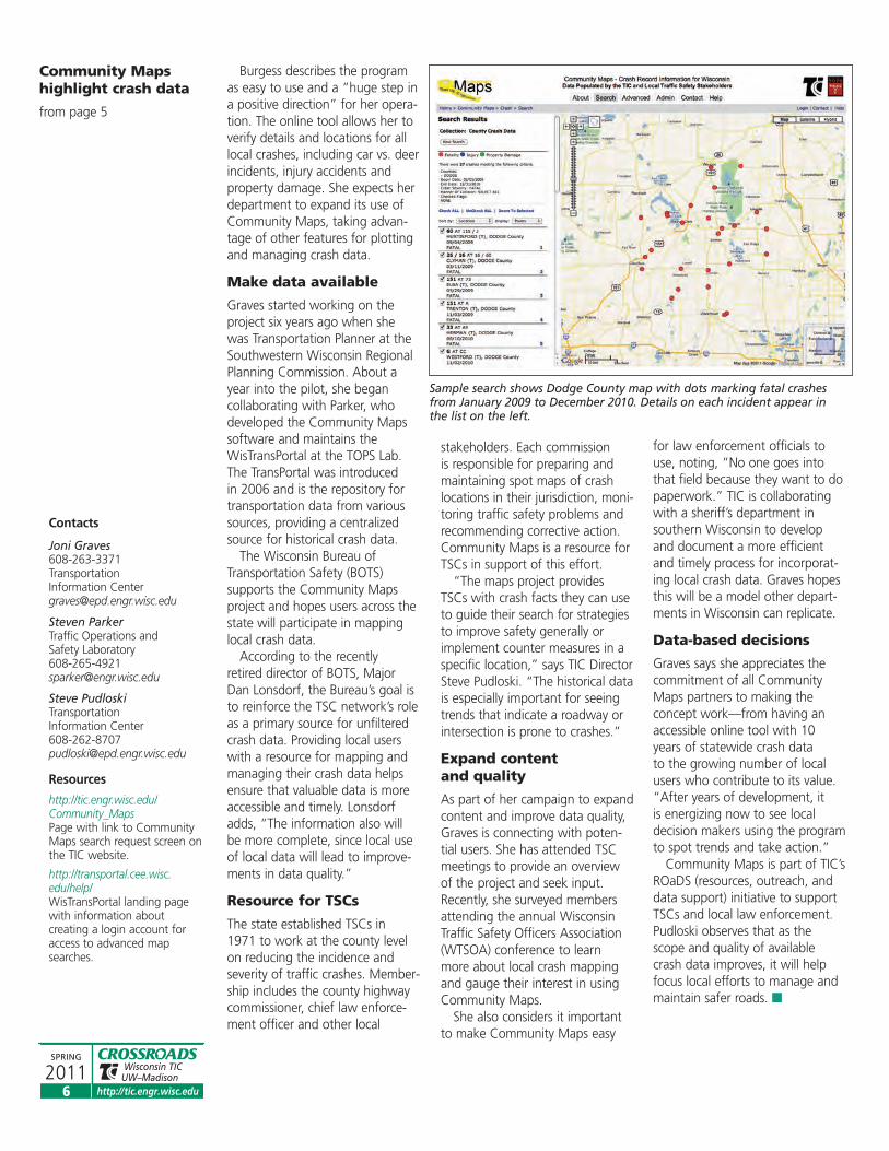
from page 5
Sample search shows Dodge County map with dots marking fatal crashesfrom January 2009 to December 2010. Details on each incident appear inthe list on the left.

http://tic.engr.wisc.eduhttp://tic.engr.wisc.edu
Wisconsin TICUW–Madison
SPRING
2011
SPRING 2011 CROSSROADS
SPRING
2011 Wisconsin TICUW–Madison
7
LOCAL GOVERNMENTSmust report their pavement ratingsto the Wisconsin Depart ment ofTransportation by December 15,2011, documenting the physicalcondition of the local roads theymanage and maintain. For mostlocal officials, the process involvesusing PASER ratings in tandemwith spreadsheets and, for a grow-ing number, submission of theirpavement data using WEB WISLR.
The web-accessible local roadsinventory system is an updatableresource where local governmentofficials can input and store details on road width, surfacetype, surface year, shoulder, curb,road category, pavement condition and other information. WISLR also assists local governments who are required to comply withGASB (Govern mental AccountingStandards Board) standards bymandating regular reports oninfrastructure assets.
Recent enhancements to WISLRgive users more reason to incorpo-rate the program into road main-tenance operations. Kelly Schieldt,Statewide Local Roads Coordinatorfor WisDOT, describes the updatesas a way for local governments totrack their preventive maintenanceprojects. The WISLR improvementsalso reflect the fact that as usersbecome proficient with the onlinetool, they are prepared to do morewith it. The additions keep WISLRrobust and relevant.
More options
With the new Route Commentsfeature, WISLR users can add, editand store additional route informa-tion such as data on culverts,drainage and associated costs thatsupport items in the PavementAnalysis section. “People wanteda way to store and access a rangeof details easily and this answersthat need,” Schieldt says.
Another enhancement is arepository for information on maintenance treatments. Givenrecent increases in maintenanceprojects, local governments aredoing more to extend the life of
their pavements and delaying theneed for more expensive rehabilita-tion and reconstruction. The addi-tion of Maintenance Treatmentslets them record treatment types inWISLR for local roads under theirjurisdiction. The mapping functionfound elsewhere in WISLR is notavailable yet for this attribute.
More users
Every year, WisDOT receives morerequests for access to WISLR.Schieldt estimates that about2,200 users statewide are goinginto the system to make ratingentries, update physical attributes,conduct a pavement analysis andperform other activities. Onlinepavement rating submittalsincreased from 42 percent of alllocal governments in 2005 to 59percent in 2009.
Local road officials not registeredfor access to WISLR can set up anaccount by following instructionsat the WISLR page on the WisDOTwebsite. However, any accountthat is inactive for 26 monthsbecomes unavailable—anotherincentive for local governments tokeep using WISLR tools in theirlocal roads programs year round.
Wider, more frequent use certainly benefits the system.WisDOT expects a WISLR UserGroup of both basic and advancedusers will offer valuable feedback.Information about participation inUser Group meetings is included in the annual mailing to local gov-ernments that contains certificationmaterials. It is also available on theTIC website.
Spread the word
Outreach has helped spread theword about WISLR. WorkshopsSchieldt and others in the depart-ment conduct with TIC give
WISLR adds features in time for ratings deadline
PASER/WISLR Web Courses WisDOT and TIC offerthree online courses thissummer for using PASERand WISLR to manage local roads. Sessions run 90 minutes. Cost: $35 foreach program. Register and download handouts at http://tic.engr.wisc.edu orcall 800-442-4615.
July 13, 1-2:30 pm How to Rate Your Roads Using PASER Build a pavement manage -ment system, interpret PASER ratings, use WISLRto submit ratings and toinventory, map, analyzeand develop budgets.
July 27, 1-2:30 pmWISLR 101 – The BasicsHow the inventory systemworks and how it relates tomileage certification andgetting access to your data.
August 10, 1-2:30 pmHow Do I Submit MyPavement Ratings?Guide to downloadable ratings forms, submittingratings via the web, andtips for modifying andworking with yourinventory data.
public officials a good way to getstarted with WISLR, refresh theirknowledge if they already use theinventory tool and ask questions.
Delivering the same experiencein a new, more cost-effective way,WisDOT and TIC will offer three90-minute PASER/WISLR webcourses this summer. Local govern-ments say they find the workshopsvaluable and welcome the chanceto attend the virtual programs.Sessions will cover how to rateroads using PASER, provide anoverview of WISLR and highlighttips for online ratings submission.See adjacent course listing withdates and other details.
There are plans to present moreweb courses in 2012 on how touse WISLR’s mapping and analysistools, and budgeting with WISLR.
Doing the job
Public officials will be busy overthe next few months inspectinglocal roads as they prepare torecord and report pavement ratings to WisDOT by December15. Whether using the basic oradvanced features of WISLR, their work is helping to make the local roads inventory systemreflect what local governmentsneed to do their job. Learn moreabout PASER and WISLR online at WisDOT and sign up for theupcoming web course sessions to become more familiar withthese programs. �
Contacts
Wisconsin Department of TransportationWISLR Hotline 608-266-2865 [email protected]
Pavement Hotline 608-266-7139
Resources
www.dot.wisconsin.gov/localgov/wislr/WisDOT WISLR informationwith links to getting started.
http://tic.engr.wisc.eduTIC site provides links toPASER/WISLR onlineworkshop registrationinformation and WISLR UserGroup meeting information.
Recent enhancements toWISLR give users morereason to incorporate the program into roadmaintenance operations.
Record details about local roadsusing WISLR.

Bezemek uses the inventory to generate colored maps designating signlocations that he gives crew members along with their assignments.Marked-up maps provide new data that goes into the inventory.
Screen shot from the Town of Necedah computerized sign inventorywhere Road Supervisor Steve Bezemek updates details on individual signs.
SUMMER 2010http://tic.engr.wisc.edu
Wisconsin TICUW–Madison
SPRING
2011
C
8
After researching inventory software products, Bezemek choseSimple Signs. He says the one-timecost of $1,500 plus $500 to addGIS mapping was a factor in hisdecision to recommend it for townboard approval. The price coversupdates, customization and techni-cal support. Final cost, including anew computer, was under $4,000. He expects the easy-to-use soft-
ware will help him meet MUTCDrequirements ahead of time. Overabout a month and a half in early2010, Bezemek entered sign datainto his laptop as he drove thetown roads, creating the initialinventory database. He started
using it to replace signs by June of2010 and completed more than200 replacements by last fall. Hisgoal is to more than double thatnumber in 2011 and complete allsign replacements over the nexttwo years.Bezemek says building the inven-
tory answered the biggest concernwith sign replacement projects:Knowing how to budget. “With -out a good sign inventory, I didn’tknow how much to set aside formaintenance,” he recalls. “Nowthat I know where we stand, I canproject what it’s going to take andhow long. And I can defend mybudget requests with hard facts.”
Bezemek considers it one of thebest operational improvements the town has ever made.
Go to next level
Peterson, who is Road andMaintenance Director for theTown of Westboro, recalls start-ing 10 years ago to stamp thebacks of signs with replacementdates to track vandalism, a serious issue in the area aroundthe Taylor County community.Hearing about sign inventorysoftware at the TIC workshopand anticipating the MUTCDdeadlines, he was ready to go to the next level. Like Bezemek, he saw Simple
Signs as a cost-wise choice forhis small agency and one thatdid not require great computerskills. “I’m no computer expertso I was glad to find a programthat is self-explanatory andguides you through the screenswithout difficulty,” Petersonsays. “I also wanted a comput-erized database where I canstore and update information,and also share it with otheragencies when necessary.” The town manages some forestroads, he notes, and the newinventory makes it easy to senddata to forest service officialswhen there is an issue.Westboro paid $2,000 for the
basic program with mapping.Peterson worked with the vendor to develop a map thatmatches the town’s needs. The89 miles of road his agencymanages cover three-and-a-halftownships so Peterson needed along skinny map that showseverything. Rowekamp set upthe screens Peterson neededwith categories like sign type,exact location, post material andother identifying factors. After working with the inter-
active sign inventory for a year,Peterson says he finds the processof inputting new data on each signstraight forward. The program alsoalerts him about scheduled mainte-nance activities. And since the signinventory map is similar to the
Resources
www.lrrb.org/Minnesota Local Roads Research Board has infor-mation about sign retro-reflectivity and management,including downloadable guides and toolkits.
http://safety.fhwa.dot.gov/roadway_dept/night_visib/retrotoolkit/FHWA developed this SignRetroreflectivity Guidebook to help local agencies select an effective sign assessment or management method.
http://www.rowekamp.com/Link to producer of Simple Signs inventory software.
http://cartegraph.com/Link to producer of SignViewinventory software.
www.mastermindsystems.com/Link to producer of SignMasterinventory software.
Bezemek saysbuilding theinventoryanswered thebiggest concernwith signreplacementprojects, knowinghow to budget.
Sign inventorymakes it easier tomeet the MUTCD
from page 1

http://tic.engr.wisc.eduhttp://tic.engr.wisc.edu
Wisconsin TICUW–Madison
SPRING
2011
SPRING 2011 CROSSROADS
SPRING
2011 Wisconsin TICUW–Madison
9
pavement ratings map he uses inWISLR, Peterson sees a real advan-tage in being able to cross-trackdetails in both systems.
“It really is easier now to setaside a realistic amount for signmaintenance in the annual budget,” Peterson says. “I canjudge what needs to be replacedand plan ahead on spending tomeet the mandates.”
Seeing the benefits
Maintaining hundreds of trafficsigns is a major part of managingsafety on local roads. A compre-hensive inventory—whether electronic or pencil and paper—should contain a range of factsabout each sign, from installationdates to its retroreflectivity score.
After a year in action, the inven-tory Bezemke implemented hasstreamlined Necedah’s sign mainte-nance operation, he says. “Withthe database loaded, I can checkon a sign in the system from theoffice, order replacements andupdate individual sign informa-tion.” The program lets him record sign location, orientationand offset, and sign properties that include size, MUTCD code,sheeting type, what kind of postand how many, the sign vendorand warranty details. An activities section contains data on installa-tion dates, retroreflectivity condi-
Once in place,the inventorybecomes avaluableworking toolthat supportsongoingmaintenanceand long-rangeplanning.
Choose a Method
The 2009 MUTCD requires public agencies to establish and implementone of five sign management or assessment methods by January 2012 tomaintain sign retroreflectivity at or above minimum levels. The standardsalso allow the use of other methods based on engineering studies.
Visual Nighttime AssessmentConduct nighttime inspections with accepted procedures forcalibration and comparison to establish minimum levels.
Measured Sign RetroreflectivityTake exact measurements of all signs using retroreflectometer.
Expected Sign LifeRecord age of sign and replace before retroreflective material is expected to degrade to minimum level.
Blanket ReplacementReplace all signs at specific intervals based on expected life of sheeting material.
Control SignsBase replacement of signs on the performance of a sample of each type of sign in a field or maintenance yard.
FACT CHECK
Sign RetroreflectivityDeadlines
There is some confusion amonglocal agencies about what each2009 MUTCD compliance daterequires of them when it comesto meeting the new national standards for sign retroreflec -tivity. The facts are these:
By January 2012All local agencies must establishand implement a sign manage-ment or assessment method thatsupports their plan for meetingminimum sign retroreflectivity levels required in MUTCD.
By January 2015All agencies must ensure thattraffic signs comply with newretro reflectivity standards. Theseinclude all regulatory, warningand ground-mounted guidesigns—except for street namesigns—that do not meet mini-mum requirements according tothe management or assessmentmethod chosen.
By January 2018Agencies must meet all signstandards, including the newretroreflectivity minimums.
ContactsSteve BezemekTown of [email protected]
Jeff PetersonTown of [email protected]
tions and comments. He also listswho performed the tasks related to installing or servicing the sign.
Bezemek and Peterson both usethe inventory to track damaged,stolen or vandalized signs. Petersonsays having a verifiable record ofproblem areas helps him flag lawenforcement about where toincrease patrols.
The program generates reportson the entire inventory or specificsegments for scheduling and budget meetings. It produces printouts the town officials use forwork assignments that they markup in the field with notes on sign condition and maintenance actions,later transferring those notes to the database. Like many small roadand street departments who relyon part-time workers to assist withmaintenance projects, Bezemekand Peterson say having inventorymaps is a good way to give assign-ments to a workforce that mightnot be familiar with area roads andsign locations. “It communicatesvery precise information aboutwhere to go and which signs towork on,” Peterson observes.
A complete sign inventory alsomakes it easier to assess the place-ment and purpose of existing signs.Bezemek says he identified unnec-essary or redundant signs using theinventory tool and locations with-out signs that needed them.
Valuable working tool
Any sign inventory that is easy tomaintain helps local agencies meetthe MUTCD deadlines for updatingnon-compliant regulatory, warningand guide signs without major strainon budget resources. Once in place,the inventory becomes a valuabletool that supports ongoing mainte-nance and long-range planning.
The Minnesota Local RoadsResearch Board offers two down-loadable publications to assist local agencies in responding to thefederal guidelines, a retro reflectivitytoolkit and a sign maintenancehandbook of best practices. Bothdiscuss the benefits of sign inven -tories. TIC’s bulletin on signing isanother good resource for local governments in Wisconsin respon -sible for the traffic signs that keep the state’s local roads safe for thedriving public. �

SUMMER 2010 http://tic.engr.wisc.eduhttp://tic.engr.wisc.edu
Wisconsin TICUW–Madison
SPRING
2011
SPRING 2011 CROSSROADS
SPRING
2011 Wisconsin TICUW–Madison
10
FEEDBACKEMAIL [email protected] 800.442.4615
FAX 608.263.3160
Wisconsin Transportation Information Center432 N. Lake Street Rm 811Madison, WI 53706
http://tic.engr.wisc.edu
CONTACT US VIA EMAIL, PHONE, FAX OR MAIL
name ____________________________________________________________ title /agency_________________________________________________
address ____________________________________________city _______________________ state _______________ zip________________________
phone _____________________________________________ fax _______________________ email__________________________________________
address change/addition information request idea/comment email delivery only
___________________________________________________________________________________________________________________
___________________________________________________________________________________________________________________
___________________________________________________________________________________________________________________
___________________________________________________________________________________________________________________
�
CROSSROADS INDEX
Administration/Budget PlanningEngineering study helps town save on road project SPRING 10
Manage an effective bid process SUMMER 10
Recovery Act dollars move into local road and bridge projects SPRING 09
Step-by-step approach on large permitting projects SPRING 09
Weight limit rule wins compliance thanks to education FALL 10
When large loads travel local roads: Tips for managing big projects SPRING 09
Equipment/FacilitiesSprayer truck does double duty FALL 09
Pavement MaintenanceChoosing cold mix WINTER 11
Closer look at Safety Edge WINTER 11
Fresh take on pothole patching and prevention SPRING 09
Full-depth reclamation made easy SPRING 10
How a pothole forms SPRING 09
Warm mix technologies emerge as paving option on local roads WINTER 11
Pavement Management/RatingsWISLR in action SUMMER 09
PoliciesAgreement expands mutual assistance concept SUMMER 10
DNR creates single points of contact WINTER 10
State releases new guidelines for speed management FALL 09
Summit planned on speed management guidelines SPRING 09
RegulationsPrepare for prevailing wage rule changes WINTER 10
Stricter diesel emission rules affect truck replacements FALL 09
U-turn legal at more intersections SUMMER 10
Resources/TrainingFHWA launches Every Day Counts WINTER 11
New online source for local roads issues WINTER 11
Snow equipment training pays off SUMMER 09
TIC resources stretch training budgets FALL 09
Training pays off even when budgets are tight SUMMER 10
RoadsidesBest practices target invasive species WINTER 10
Early response to tree disease eases budget impact FALL 10
Q&A on invasive species SUMMER 10
Safety/HighwayCheck intersection sight distance in the field SUMMER 09
Considering local speed limits, speed and safety SPRING 09
Improve intersection sight distances SUMMER 09
Local cooperation achieves needed road makeover SPRING 09
Speed studies strengthen local partnerships for safety FALL 09
Strategies for safe roads subject of workshop FALL 10
Safety/PedestrianPedestrian safety improvements a joint effort WINTER 11
Safety/WorkersMake safe work zones a priority SPRING 10
Worker safety by the book FALL 10
Signs/MarkingsRevised MUTCD sets new safety standards SPRING 10
Sign retroreflectivity: on the road to compliance WINTER 10
Winter RoadsPlow blade advances improve snow control SUMMER 09
Positive results from dairy brine test on winter roads FALL 10
Articles from the last eight issues of Crossroads newsletter listed by topic, title and issue date. Available for download at http://tic.engr.wisc.edu or call the Transportation Information Center at 800-442-4615 to request copies.
Spring 2009 – Winter 2011

http://tic.engr.wisc.eduhttp://tic.engr.wisc.edu
Wisconsin TICUW–Madison
11
RESOURCES
CROSSROADS provides road andbridge information for local officials.published quarterly by the Wisconsintransportation informa tion center(tic) at the University of Wisconsin–
madison, it is part of the nationwidelocal techni cal assis tance program(ltap). tic is oper ated by theUniversity of Wisconsin–madison and sponsored by the Wisconsindepart ment of trans por tation and the federal highway adminis tra tion.please contact us for permission toreproduce articles or graphics.
Steve Pudloski, [email protected]
Ben Jordan, Staff [email protected]
Katie Pawley, Program [email protected]
Mary Maher, Writer/EditorWRITING & CREATIVE CONCEPTS
Susan Kummer, Graphic DesignerARTIFAX, PUBLICATIONS BY DESIGN
EMAIL [email protected] 800.442.4615
FAX 608.263.3160
Wisconsin Transportation Information Center432 N. Lake Street Rm 811Madison, WI 53706
http://tic.engr.wisc.edu
Publications
PASER Manual Series, 2000-02.Pavement Surface Evaluation andRating manuals provide help withroad ratings process, and review of surface condition and repairs formost road surface types. Describesand illustrates common defects.Includes surface rating system thatlinks type, number and severity ofdefects with maintenance methods.Six manuals available from TIC inprint or electronic versions.
Asphalt PASER Manual39 pp., 2002
Brick and Block PASER Manual8 pp., 2001
Concrete PASER Manual48 pp., 2002
Gravel PASER Manual32 pp., 2002
Sealcoat PASER Manual16 pp., 2000
Unimproved Roads PASER Manual12 pp., 2001
Signing for Local Roads, TICBulletin #7, 12 pp., updated 2011.Reviews role of local governments inmaintaining safe, effective trafficsigns on local roads. Includes latestMUTCD and WisDOT guidelines forplacement and installation, detailson sign types and sizes. Available inprint or electronic versions.
Print copies of listedpublications available free from TIC. Down - load or request items at Publica tions on TICwebsite. Video, CDs, and DVDs loaned free at county UW-Extensionoffices. Also see VideoCatalog on TIC website.
TIC websitehttp://tic.engr.wisc.edu/
Web Sources
FHWA Sign RetroreflectivityGuidebook provides an interactiveonline resource for local agencieswho are selecting a sign assessmentor management method. IncludesQ&A that helps users identify thebest method to implement byJanuary 2012. Some copies availablein print from TIC.http://safety.fhwa.dot.gov/roadway_dept/night_visib/retrotoolkit/
The Minnesota Local Roads ResearchBoard offers two sign retroreflectivityand management publications asdownloads. Sign Retroreflectivity:A Minnesota Toolkit reviews signassessment and management methods. Includes examples andrelated resources. The Traffic SignMaintenance/ManagementHandbook is a guide to best practices and compliance in signmanagement and maintenance.www.lrrb.org/
Follow WISLR link on TIC home page for information about the localroads inventory system, including aPavement Rating Help Guide andaccess to registering for or logginginto WISLR.http://tic.engr.wisc.edu/Links/WISLR.lasso
Urban Bikeway Design Guide from
the National Association of CityTransportation Officials (NACTO)provides best practices for improvingbicycle transportation in placeswhere competing demands for theuse of the right-of-way presentunique challenges. Contains infor-mation on successful implementa-tion of bicycle facilities and detailedstudies. Follow these links to onlineor print guides.http://nacto.org/cities-for-cycling/design-guide/
http://nacto.org/print-guide/
FHWA Bicycle Facilities and theManual on Uniform TrafficControl Devices includes a tablethat lists bicycle-related signs, mark-ings, signals and other treatments.Also indicates which bicycle facilitiesdo and do not fall under the scopeof the 2009 MUTCD and which areexperimental.www.fhwa.dot.gov/environment/bikeped/mutcd_bike.htm
Two recent Specifier Reports fromthe National Lighting ProductInformation Program of the LightingResearch Center at RensselaerPolytechnic Institute explore use ofLED streetlights designed to meet IES RP-8 standards.
Street Lights for Collector Roadsavailable at:www.lrc.rpi.edu/nlpip/publicationDetails.asp?id=927&type=1
Streetlights for Local Roads isavailable at:www.lrc.rpi.edu/nlpip/publicationDetails.asp?id=931&type=1
Demonstration Assessment ofLight-Emitting Diode (LED)Roadway Lighting on Residentialand Commercial Streets, Host Site:Palo Alto, California, a Solid-StateLighting Technology DemonstrationGATEWAY Program Report publishedin June 2010 by the DOE. www1.eere.energy.gov/buildings/ssl/gatewaydemos.html
Climate white paper Street Lighting Retrofit Projects;Improving Performance while Reducing Costs andGreenhouse Gas Emissions, published in June 2010 by theClinton Foundation. www.clintonfoundation.org/files/CCI_whitepaper_lighting_2010.pdf
This University of Pittsburgh studycompares environmental impact ofLED technology for streetlighting to conventional lighting systems.www.news.pitt.edu/news/led-streetlights-best-buy-cities-pitt-researchers-report-first-cradle-grave-comparison-common-a
DVD/VHS/ Multimedia
PASER Ratings Series, University of Wisconsin-Madison, 2000, 74 minutes, #18390 VHS. Singlecassette with three PASER trainingvideos includes Asphalt PASER,Gravel PASER and Sealcoat PASER.Learn how to evaluate and ratepavement conditions using PASERmanuals. Also available as individualprograms:
#17761 Asphalt PASER (46 min.)
#18385 Gravel PASER (15 min.)
#18386 Sealcoat PASER (13 min.)
NEW
Wisconsin TICUW–Madison
SPRING
2011
SPRING 2011 CROSSROADS
SPRING
2011

http://tic.engr.wisc.eduhttp://tic.engr.wisc.edu
Wisconsin TICUW–Madison
SPRING
2011
SPRING 2011 CROSSROADS
SPRING
2011 Wisconsin TICUW–Madison
12
TIC Workshops
Details, locations & registration formssent to Crossroads recipients prior toeach workshop. More information &online registration at http://tic.engr.wisc.edu/workshops/listing.lasso
Online PASER and WISLR workshops
Learn the PASER pavement condition rating system and howto use the WISLR mapping andGIS tools to more effectivelymanage your roads. Register forthese online workshop sessionsat http://tic.engr.wisc.edu anddownload handouts or call 800-442-4615. Fee: $35 foreach 90-minute program.
July 13, 1-2:30 pm How to Rate Your RoadsUsing PASER
July 27, 1-2:30 pmWISLR 101-The Basics
August 10, 1-2:30 pmHow Do I Submit MyPavement Ratings?
prsrt-stdU.s. postage
p a i dmadison,Wi
permit no. 658
© 2011 tic–ltap printed on recycled paper
CALENDAR
Wisconsin Transportation Information Center432 N. Lake Street Room 811Madison, WI 53706
What’sINSIDE
1 Sign inventory helps with MUTCD deadlines2 Streetlighting with LEDs5 Community Maps highlight crash data7 WISLR adds features
10 Crossroads Article Index11 Resources12 Calendar ”
On-Site Workshops
Save time and travel costs by scheduling training at your shop oroffice. It’s convenient and coursescan be tailored to your specificneeds. On-site workshops let you
train morepeople forthe samecost or less,includingstaff fromother muni-cipal depart-ments, near-by commu-nities, orbusinesses
you contract with. Contact TIC tobook the program and date youwant. On-site workshops include:
• Basic Surveying for LocalHighway Departments
• Basic Work Zone Traffic Control
• Flagger Training
UW-Madison Seminars
Local govern ment officials are eligible for alimited number of scholarships for theseEPD courses held in Madison. Go to http://epd.engr.wisc.edu or call 800-462-0876.
J U n e 2 0 1 1
6-7 comprehensive practices foreffective construction projectmanagement #l570
8 principles and practices ofconstruction project scheduling#l571
9-10 principles and practices ofestimating for construction anddesign professionals #l572
20-22 solving neighborhood trafficproblems #l945
a U g U s t 2 0 1 1
16-18 designing temporary trafficcontrol plans for complicatedprojects #m640
16-18 traffic engineeringfundamentals #m716
s e p t e m B e r 2 0 1 1
7-9 preventing and detectingdeficiencies in design andconstruction documents #m594
12-13 introductory principles ofengineering project management #m595
14-15 management skills-engineeringcapital projects #m596
o c t o B e r 2 0 1 1
3-4 essentials of hydraulics for civil engineers and designers#m523
10-12 roundabouts: effective geometric design #l944
17-18 managing snow and ice control operations #m845
24-28 structural design for non-structural engineers #l566
Independent Study
Project Management 100: TheBasics, Plus Important Insights #L742
Enroll Anytime
http://tic.engr.wisc.edu
The historical data isespecially important forseeing trends that indicatea roadway or intersection is prone to crashes.
– page 6
“
CROSSROADS