Shuttle Feasibility Study
145
Transcript of Shuttle Feasibility Study


Shuttle Feasibility Study for the Rocky MountainArsenal National Wildlife Refuge,
Commerce City, and the Stapleton Area
Final Report
Prepared for:
City of Commerce City7887 East 60th Avenue
Commerce City, CO 80022
Prepared by:
LSC Transportation Consultants, Inc.516 North Tejon Street
Colorado Springs, CO 80903(719) 633-2868
LSC #084790
February 25, 2009

-ii-
TABLE OF CONTENTS
Chapter Title Page
I INTRODUCTION . . . . . . . . . . . . . . . . . . . . . . . . . . . . . . . . . . . . . . . . . . . . I-1Study Background . . . . . . . . . . . . . . . . . . . . . . . . . . . . . . . . . . . . . . . . . . . I-1Organization of This Report . . . . . . . . . . . . . . . . . . . . . . . . . . . . . . . . . . . . I-4
II EVALUATION OF CURRENT CONDITIONS . . . . . . . . . . . . . . . . . . . . . . . . II-1Introduction . . . . . . . . . . . . . . . . . . . . . . . . . . . . . . . . . . . . . . . . . . . . . . II-1Review of Previous Plans . . . . . . . . . . . . . . . . . . . . . . . . . . . . . . . . . . . . . II-1
Rocky Mountain Arsenal National Wildlife Refuge Comprehensive Management Plan . . . . . . . . . . . . . . . . . . . . . . . . . II-2
New Lands Comprehensive Plan . . . . . . . . . . . . . . . . . . . . . . . . . . . . . II-2City of Commerce City Comprehensive Plan 1985-2010 . . . . . . . . . . . . II-3New Lands Transportation Plan . . . . . . . . . . . . . . . . . . . . . . . . . . . . . II-3The Prairie Gateway Project Feasibility Study and
Proposed Development Strategy . . . . . . . . . . . . . . . . . . . . . . . . . . . II-4Prairie Gateway Traffic Impact Study . . . . . . . . . . . . . . . . . . . . . . . . . II-4Prairieways Action Plan, Guidelines for Park, Trails, and Open Space . II-4North Stapleton Infrastructure Master Plan . . . . . . . . . . . . . . . . . . . . . II-5DRCOG 2035 Metro Vision Regional Transportation Plan . . . . . . . . . . II-5Conclusion . . . . . . . . . . . . . . . . . . . . . . . . . . . . . . . . . . . . . . . . . . . . . II-6
Rocky Mountain Arsenal Visitor Projections . . . . . . . . . . . . . . . . . . . . . . . II-6Traffic Volume Growth Rates in Study Area . . . . . . . . . . . . . . . . . . . . . . . II-7Current Transit Service in Study Area . . . . . . . . . . . . . . . . . . . . . . . . . . II-10
Route 40: Colorado Boulevard, Crosstown . . . . . . . . . . . . . . . . . . . . . II-10Route 43: Martin Luther King Boulevard/Gateway . . . . . . . . . . . . . . II-10Route 48: East 48th Avenue/Commerce City . . . . . . . . . . . . . . . . . . . II-10Route 72: 72nd Avenue Crosstown . . . . . . . . . . . . . . . . . . . . . . . . . . . II-12Route 88: Northglenn/Commerce City/Stapleton . . . . . . . . . . . . . . . II-12Adams County Community Transit (A-Lift) . . . . . . . . . . . . . . . . . . . . II-12
Existing Trails . . . . . . . . . . . . . . . . . . . . . . . . . . . . . . . . . . . . . . . . . . . . II-12
III KEY PERSON INTERVIEWS . . . . . . . . . . . . . . . . . . . . . . . . . . . . . . . . . . III-1Introduction . . . . . . . . . . . . . . . . . . . . . . . . . . . . . . . . . . . . . . . . . . . . . . III-1
Question 1: In your opinion, what are the major issues facing Commerce City, the Stapleton Area, and the Rocky Mountain Arsenal National Wildlife Refuge? . . . . . . . . . . . . . . . . . . . . . . . . . . . . . . . . . . . . . . . III-1
Question 2: In your opinion, what are the major transportation issues facing the area? . . . . . . . . . . . . . . . . . . . . . . . . . . . . . . . . . . . . . . . III-2
Question 3: What, in your opinion, are the needs of the area for local andregional transit service? . . . . . . . . . . . . . . . . . . . . . . . . . . . . . . . . . III-2
Question 4: What benefits do you think improved transit service would bring to the area? . . . . . . . . . . . . . . . . . . . . . . . . . . . . . . . . . . . . . III-3
Question 5: Does the current transit service meet those needs? . . . . . . III-3Question 6: What areas should be given priority for local transit
service? . . . . . . . . . . . . . . . . . . . . . . . . . . . . . . . . . . . . . . . . . . . . . III-3Question 7: What changes would you like to see in the current transit
service? . . . . . . . . . . . . . . . . . . . . . . . . . . . . . . . . . . . . . . . . . . . . . III-3Question 8: What should be the hours and days of service? . . . . . . . . . III-3Question 9: What do you think would make transit service succeed in
your community? . . . . . . . . . . . . . . . . . . . . . . . . . . . . . . . . . . . . . III-4

-iii-
Question 10: What do you think is the greatest barrier to enhanced public transit in the community? . . . . . . . . . . . . . . . . . . . . . . . . . . III-5
Question 11: What changes would you like to see in the current roadway network? . . . . . . . . . . . . . . . . . . . . . . . . . . . . . . . . . . . . . III-5
Question 12: What areas should be given priority for highway and roadway improvement? . . . . . . . . . . . . . . . . . . . . . . . . . . . . . . III-6
Question 13: What areas should be given priority for pedestrian and bikeway improvement? . . . . . . . . . . . . . . . . . . . . . . . . . . . . . . . . . III-6
Question 14: Do you think that the community would support increasedfunding to improve public transportation services to the Rocky Mountain Arsenal National Wildlife Refuge? If so, what type of funding should be used? . . . . . . . . . . . . . . . . . . . . . . . . . . . . . . III-6
Question 15: Are there specific issues which should be addressed in ourShuttle Feasibility Study for the Rocky Mountain Arsenal NationalWildlife Refuge, Commerce City, and Stapleton Area? . . . . . . . . . . . III-7
Question 16: Is there anyone else we should be interviewing? Public officials? The Chamber? Private individuals? . . . . . . . . . . . . . . . . . III-7
Question 17: Do you have any other comments? . . . . . . . . . . . . . . . . . III-7Summary . . . . . . . . . . . . . . . . . . . . . . . . . . . . . . . . . . . . . . . . . . . . . . . . . III-7
IV TRANSIT DEMAND ASSESSMENT . . . . . . . . . . . . . . . . . . . . . . . . . . . . . . IV-1Introduction . . . . . . . . . . . . . . . . . . . . . . . . . . . . . . . . . . . . . . . . . . . . . . IV-1Market Segments . . . . . . . . . . . . . . . . . . . . . . . . . . . . . . . . . . . . . . . . . . . IV-1
Current Population . . . . . . . . . . . . . . . . . . . . . . . . . . . . . . . . . . . . . . . IV-1Household Density . . . . . . . . . . . . . . . . . . . . . . . . . . . . . . . . . . . . IV-3Low-Income Population . . . . . . . . . . . . . . . . . . . . . . . . . . . . . . . . . IV-3Mobility-Limited Population . . . . . . . . . . . . . . . . . . . . . . . . . . . . . . IV-6Zero-Vehicle Households . . . . . . . . . . . . . . . . . . . . . . . . . . . . . . . . IV-6Elderly Population . . . . . . . . . . . . . . . . . . . . . . . . . . . . . . . . . . . . . IV-9
Future Population Growth . . . . . . . . . . . . . . . . . . . . . . . . . . . . . . . . . IV-9Greatest Transit Need Index . . . . . . . . . . . . . . . . . . . . . . . . . . . . . . . . . . IV-12
Methodology . . . . . . . . . . . . . . . . . . . . . . . . . . . . . . . . . . . . . . . . . . . IV-12Results . . . . . . . . . . . . . . . . . . . . . . . . . . . . . . . . . . . . . . . . . . . . . . . IV-14
Existing Ridership . . . . . . . . . . . . . . . . . . . . . . . . . . . . . . . . . . . . . . . . . IV-16Activity Centers . . . . . . . . . . . . . . . . . . . . . . . . . . . . . . . . . . . . . . . . . . . IV-19Refuge Demand . . . . . . . . . . . . . . . . . . . . . . . . . . . . . . . . . . . . . . . . . . . IV-21
Visitor Demand Estimation . . . . . . . . . . . . . . . . . . . . . . . . . . . . . . . . IV-21Visitor Data . . . . . . . . . . . . . . . . . . . . . . . . . . . . . . . . . . . . . . . . . . . IV-21Transit Programs . . . . . . . . . . . . . . . . . . . . . . . . . . . . . . . . . . . . . . . IV-22Vehicle Occupancy . . . . . . . . . . . . . . . . . . . . . . . . . . . . . . . . . . . . . . IV-25Visitor Demand Estimates . . . . . . . . . . . . . . . . . . . . . . . . . . . . . . . . IV-25
Stakeholders’ Needs . . . . . . . . . . . . . . . . . . . . . . . . . . . . . . . . . . . . . . . . IV-26Conclusion . . . . . . . . . . . . . . . . . . . . . . . . . . . . . . . . . . . . . . . . . . . . . . IV-26
V SERVICE OPTIONS . . . . . . . . . . . . . . . . . . . . . . . . . . . . . . . . . . . . . . . . . V-1Introduction . . . . . . . . . . . . . . . . . . . . . . . . . . . . . . . . . . . . . . . . . . . . . . V-1Service Options . . . . . . . . . . . . . . . . . . . . . . . . . . . . . . . . . . . . . . . . . . . . V-1
Service Option 1: Fitzsimons to Commerce City . . . . . . . . . . . . . . . . . . V-1Priority I Destinations Served . . . . . . . . . . . . . . . . . . . . . . . . . . . . . V-2Priority II Destinations Served . . . . . . . . . . . . . . . . . . . . . . . . . . . . V-2Priority III Destinations Served . . . . . . . . . . . . . . . . . . . . . . . . . . . V-2
Service Option 2: RMANWR Trailhead Service . . . . . . . . . . . . . . . . . . . V-5Priority I Destinations Served . . . . . . . . . . . . . . . . . . . . . . . . . . . . . V-5Priority II Destinations Served . . . . . . . . . . . . . . . . . . . . . . . . . . . . V-5

-iv-
Priority III Destinations Served . . . . . . . . . . . . . . . . . . . . . . . . . . . V-5Service Option 3: Bell Creek Recreational Center - RMANWR
Visitor Center . . . . . . . . . . . . . . . . . . . . . . . . . . . . . . . . . . . . . . . V-8Priority I Destinations Served . . . . . . . . . . . . . . . . . . . . . . . . . . . . . V-8Priority II Destinations Served . . . . . . . . . . . . . . . . . . . . . . . . . . . . V-8Priority III Destinations Served . . . . . . . . . . . . . . . . . . . . . . . . . . . V-8
Service Option 4: Downtown Circulator . . . . . . . . . . . . . . . . . . . . . . . V-11Priority I Destinations Served . . . . . . . . . . . . . . . . . . . . . . . . . . . . V-11Priority II Destinations Served . . . . . . . . . . . . . . . . . . . . . . . . . . . V-11Priority III Destinations Served . . . . . . . . . . . . . . . . . . . . . . . . . . V-11
Service Option 5: Northfield Mall - RMANWR Visitor Center . . . . . . . . V-14Priority I Destinations Served . . . . . . . . . . . . . . . . . . . . . . . . . . . . V-14Priority II Destinations Served . . . . . . . . . . . . . . . . . . . . . . . . . . . V-14Priority III Destinations Served . . . . . . . . . . . . . . . . . . . . . . . . . . V-14
Service Option 6: Events Route . . . . . . . . . . . . . . . . . . . . . . . . . . . . . V-17Priority I Destinations Served . . . . . . . . . . . . . . . . . . . . . . . . . . . . V-17Priority II Destinations Served . . . . . . . . . . . . . . . . . . . . . . . . . . . V-17Priority III Destinations Served . . . . . . . . . . . . . . . . . . . . . . . . . . V-17
Service Option 7: Commerce City Shuttle . . . . . . . . . . . . . . . . . . . . . V-20Priority I Destinations Served . . . . . . . . . . . . . . . . . . . . . . . . . . . . V-20Priority II Destinations Served . . . . . . . . . . . . . . . . . . . . . . . . . . . V-20Priority III Destinations Served . . . . . . . . . . . . . . . . . . . . . . . . . . V-20
RTD-Denver Route 88 Realignment Options . . . . . . . . . . . . . . . . . . . . . . V-23RMANWR Tram Service . . . . . . . . . . . . . . . . . . . . . . . . . . . . . . . . . . . . . V-23Bike and Pedestrian Connections . . . . . . . . . . . . . . . . . . . . . . . . . . . . . . V-23Priority Destinations Served . . . . . . . . . . . . . . . . . . . . . . . . . . . . . . . . . . V-26Ridership Estimation Methodology . . . . . . . . . . . . . . . . . . . . . . . . . . . . . V-28
VI SHUTTLE IMPACTS TO AREA . . . . . . . . . . . . . . . . . . . . . . . . . . . . . . . . . VI-1Introduction . . . . . . . . . . . . . . . . . . . . . . . . . . . . . . . . . . . . . . . . . . . . . . VI-1Economic Benefits of Transit . . . . . . . . . . . . . . . . . . . . . . . . . . . . . . . . . . VI-1
Net Economic Benefit . . . . . . . . . . . . . . . . . . . . . . . . . . . . . . . . . . . . . VI-1IMPLAN Model for Public Transit . . . . . . . . . . . . . . . . . . . . . . . . . . . . . VI-2Input/Output Multipliers . . . . . . . . . . . . . . . . . . . . . . . . . . . . . . . . . . VI-2Economic Benefit Scenarios . . . . . . . . . . . . . . . . . . . . . . . . . . . . . . . . VI-3
Environmental Benefits of Transit . . . . . . . . . . . . . . . . . . . . . . . . . . . . . . VI-7Improves Air Quality . . . . . . . . . . . . . . . . . . . . . . . . . . . . . . . . . . . . . . VI-7Reduces the Land for Development . . . . . . . . . . . . . . . . . . . . . . . . . . . VI-8Reduces Congestion and Prevents Widening Highways . . . . . . . . . . . . VI-8
Increase in Visitation . . . . . . . . . . . . . . . . . . . . . . . . . . . . . . . . . . . . . . . . VI-8
VII PREFERRED SERVICE PLAN . . . . . . . . . . . . . . . . . . . . . . . . . . . . . . . . . VII-1Introduction . . . . . . . . . . . . . . . . . . . . . . . . . . . . . . . . . . . . . . . . . . . . . VII-1Service Plan . . . . . . . . . . . . . . . . . . . . . . . . . . . . . . . . . . . . . . . . . . . . . . VII-1
Service Plan Costs . . . . . . . . . . . . . . . . . . . . . . . . . . . . . . . . . . . . . . VII-4Preferred Service Plan Options . . . . . . . . . . . . . . . . . . . . . . . . . . . . . . . . VII-6
Alternative 1 - Hourly Service . . . . . . . . . . . . . . . . . . . . . . . . . . . . . . VII-6Alternative 2 - Peak Period Service . . . . . . . . . . . . . . . . . . . . . . . . . . VII-7Alternative 3 - Service from Northfield to the RMANWR . . . . . . . . . . . VII-9Alternative 4 - Event Service . . . . . . . . . . . . . . . . . . . . . . . . . . . . . . VII-11Alternative 5 - Seasonal Service . . . . . . . . . . . . . . . . . . . . . . . . . . . VII-11
VIII MARKETING AND MONITORING PLAN . . . . . . . . . . . . . . . . . . . . . . . . . . VIII-1Introduction . . . . . . . . . . . . . . . . . . . . . . . . . . . . . . . . . . . . . . . . . . . . . VIII-1

-v-
Proposed Marketing Plan . . . . . . . . . . . . . . . . . . . . . . . . . . . . . . . . . . . . VIII-2Increase Public Awareness and Visibility . . . . . . . . . . . . . . . . . . . . . . VIII-2Promote Service to Users . . . . . . . . . . . . . . . . . . . . . . . . . . . . . . . . . VIII-2One-Year Marketing Plan . . . . . . . . . . . . . . . . . . . . . . . . . . . . . . . . . VIII-3
Business Outreach . . . . . . . . . . . . . . . . . . . . . . . . . . . . . . . . . . . VIII-3Review Passenger Information . . . . . . . . . . . . . . . . . . . . . . . . . . . VIII-4Customer Surveys . . . . . . . . . . . . . . . . . . . . . . . . . . . . . . . . . . . . VIII-4
Website . . . . . . . . . . . . . . . . . . . . . . . . . . . . . . . . . . . . . . . . . . . . . . VIII-7PDF Files . . . . . . . . . . . . . . . . . . . . . . . . . . . . . . . . . . . . . . . . . . . VIII-8Schedules and Maps . . . . . . . . . . . . . . . . . . . . . . . . . . . . . . . . . . VIII-8Accessibility for Persons with Disabilities . . . . . . . . . . . . . . . . . . . VIII-8
Marketing Budget . . . . . . . . . . . . . . . . . . . . . . . . . . . . . . . . . . . . . . . . . VIII-9Marketing Budget . . . . . . . . . . . . . . . . . . . . . . . . . . . . . . . . . . . . . . VIII-10
Monitoring Program . . . . . . . . . . . . . . . . . . . . . . . . . . . . . . . . . . . . . . . VIII-11Ridership . . . . . . . . . . . . . . . . . . . . . . . . . . . . . . . . . . . . . . . . . . . . VIII-11One-Time Performance . . . . . . . . . . . . . . . . . . . . . . . . . . . . . . . . . . VIII-13Financial Data . . . . . . . . . . . . . . . . . . . . . . . . . . . . . . . . . . . . . . . . VIII-13Database Formats . . . . . . . . . . . . . . . . . . . . . . . . . . . . . . . . . . . . . VIII-13Reporting . . . . . . . . . . . . . . . . . . . . . . . . . . . . . . . . . . . . . . . . . . . . VIII-14
IX STRATEGIC IMPLEMENTATION PLAN . . . . . . . . . . . . . . . . . . . . . . . . . . . IX-1Introduction . . . . . . . . . . . . . . . . . . . . . . . . . . . . . . . . . . . . . . . . . . . . . . IX-1Organizational Plan . . . . . . . . . . . . . . . . . . . . . . . . . . . . . . . . . . . . . . . . . IX-1Service Plan . . . . . . . . . . . . . . . . . . . . . . . . . . . . . . . . . . . . . . . . . . . . . . . IX-2
Description of Service . . . . . . . . . . . . . . . . . . . . . . . . . . . . . . . . . . . . . IX-3Fares . . . . . . . . . . . . . . . . . . . . . . . . . . . . . . . . . . . . . . . . . . . . . . . IX-3Schedules . . . . . . . . . . . . . . . . . . . . . . . . . . . . . . . . . . . . . . . . . . . IX-4Local Service Vehicles . . . . . . . . . . . . . . . . . . . . . . . . . . . . . . . . . . IX-4
Service Summary . . . . . . . . . . . . . . . . . . . . . . . . . . . . . . . . . . . . . . . . IX-5Benefits . . . . . . . . . . . . . . . . . . . . . . . . . . . . . . . . . . . . . . . . . . . . . IX-5Responsibility . . . . . . . . . . . . . . . . . . . . . . . . . . . . . . . . . . . . . . . . IX-5
Financial Options . . . . . . . . . . . . . . . . . . . . . . . . . . . . . . . . . . . . . . . . . . IX-5Short-Term Implementation Plan . . . . . . . . . . . . . . . . . . . . . . . . . . . . . . . IX-8
Formalize Transit Council . . . . . . . . . . . . . . . . . . . . . . . . . . . . . . . . . . IX-8Create a Budget and Secure Funding for Services . . . . . . . . . . . . . . . . IX-8Obtain Funding . . . . . . . . . . . . . . . . . . . . . . . . . . . . . . . . . . . . . . . . . IX-8
Timing . . . . . . . . . . . . . . . . . . . . . . . . . . . . . . . . . . . . . . . . . . . . . . IX-8Responsibility . . . . . . . . . . . . . . . . . . . . . . . . . . . . . . . . . . . . . . . . IX-9
Finalize Service Plan . . . . . . . . . . . . . . . . . . . . . . . . . . . . . . . . . . . . . . IX-9Timing . . . . . . . . . . . . . . . . . . . . . . . . . . . . . . . . . . . . . . . . . . . . . . IX-9Responsibility . . . . . . . . . . . . . . . . . . . . . . . . . . . . . . . . . . . . . . . . IX-9
Develop Contract with RTD . . . . . . . . . . . . . . . . . . . . . . . . . . . . . . . . . IX-9Timing . . . . . . . . . . . . . . . . . . . . . . . . . . . . . . . . . . . . . . . . . . . . . . IX-9Responsibility . . . . . . . . . . . . . . . . . . . . . . . . . . . . . . . . . . . . . . . . IX-9
Develop Marketing/Promotional Materials . . . . . . . . . . . . . . . . . . . . . . IX-9Timing . . . . . . . . . . . . . . . . . . . . . . . . . . . . . . . . . . . . . . . . . . . . . IX-10Responsibility . . . . . . . . . . . . . . . . . . . . . . . . . . . . . . . . . . . . . . . IX-11
Begin Services . . . . . . . . . . . . . . . . . . . . . . . . . . . . . . . . . . . . . . . . . IX-11Recommend Additional Plans and Studies . . . . . . . . . . . . . . . . . . . . . . . IX-11

-vi-
LIST OF TABULATIONS
Table Title Page
II-1 Estimated Vehicle Traffic (Phase II) . . . . . . . . . . . . . . . . . . . . . . . . . . . . II-7II-2 Estimated Traffic Volumes . . . . . . . . . . . . . . . . . . . . . . . . . . . . . . . . . . . II-8
IV-1 Greatest Transit Need Scores by Census Block Group . . . . . . . . . . . . . IV-13
V-1 Route 1 - Fitzsimons to Commerce City - Service Characteristics . . . . . . V-4V-2 Route 2 - Refuge/Trailheads - Service Characteristics . . . . . . . . . . . . . . V-7V-3 Route 3 - Flea Market/Trails/Refuge - Service Characteristics . . . . . . . V-10V-4 Route 4 - Downtown Circulator - Service Characteristics . . . . . . . . . . . V-13V-5 Route 5 - Northfield/Refuge - Service Characteristics . . . . . . . . . . . . . . V-16V-6 Route 6 - Event/Hotels - Service Characteristics . . . . . . . . . . . . . . . . . V-19V-7 Route 7 - Northfield/Stapleton/Refuge - Service Characteristics . . . . . V-12V-8 Points Served by Route . . . . . . . . . . . . . . . . . . . . . . . . . . . . . . . . . . . . V-27V-9 Service Options Annual Ridership Estimate . . . . . . . . . . . . . . . . . . . . . V-29
VI-1 Economic Benefits of Route 1 . . . . . . . . . . . . . . . . . . . . . . . . . . . . . . . . VI-4VI-2 Economic Benefits of Route 2 . . . . . . . . . . . . . . . . . . . . . . . . . . . . . . . . VI-4VI-3 Economic Benefits of Route 3 . . . . . . . . . . . . . . . . . . . . . . . . . . . . . . . . VI-5VI-4 Economic Benefits of Route 4 . . . . . . . . . . . . . . . . . . . . . . . . . . . . . . . . VI-5VI-5 Economic Benefits of Route 5 . . . . . . . . . . . . . . . . . . . . . . . . . . . . . . . . VI-6VI-6 Economic Benefits of Route 6 . . . . . . . . . . . . . . . . . . . . . . . . . . . . . . . . VI-6VI-7 Economic Benefits of Route 7 . . . . . . . . . . . . . . . . . . . . . . . . . . . . . . . . VI-7
VII-1 RTD Performance Standards for Suburban Local Service . . . . . . . . . . . VII-2VII-2 Preferred Route - Northfield/Stapleton/Refuge -
Service Characteristics . . . . . . . . . . . . . . . . . . . . . . . . . . . . . . . . . . VII-5VII-3 Alternative 1 - Hourly Service 6 a.m. - 10 p.m. . . . . . . . . . . . . . . . . . . . VII-6VII-4 Sample Route Schedule – One-Hour Service Frequency . . . . . . . . . . . . VII-7VII-5 Alternative 2 - Peak Service 6 a.m. - 10 p.m. . . . . . . . . . . . . . . . . . . . . VII-8VII-6 Sample Route Schedule – Peak Period Service . . . . . . . . . . . . . . . . . . . VII-9VII-7 Alternative 3 - Service From Northfield to RMANWR . . . . . . . . . . . . . . VII-10VII-8 Sample Route Schedule – Service From Northfield to RMANWR . . . . . VII-10VII-9 Alternative 5 - Seasonal Service . . . . . . . . . . . . . . . . . . . . . . . . . . . . . VII-12VII-10 Alternative 5 - Summer Schedule . . . . . . . . . . . . . . . . . . . . . . . . . . . VII-13VII-11 Alternative 5 - Winter Service . . . . . . . . . . . . . . . . . . . . . . . . . . . . . . VII-13
VIII-1 One-Year Marketing Plan . . . . . . . . . . . . . . . . . . . . . . . . . . . . . . . . . . . VIII-5VIII-2 Marketing Budget . . . . . . . . . . . . . . . . . . . . . . . . . . . . . . . . . . . . . . . VIII-11
IX-1 Preferred Short-Term Service Plan . . . . . . . . . . . . . . . . . . . . . . . . . . . . . IX-3IX-2 Proposed Fare Structure . . . . . . . . . . . . . . . . . . . . . . . . . . . . . . . . . . . . IX-2IX-3 Sample Route Schedule . . . . . . . . . . . . . . . . . . . . . . . . . . . . . . . . . . . . . IX-4IX-4 Option 1: Local/User Funded . . . . . . . . . . . . . . . . . . . . . . . . . . . . . . . . IX-4

-vii-
LIST OF ILLUSTRATIONS
Figure Title Page
I-1 Study Area . . . . . . . . . . . . . . . . . . . . . . . . . . . . . . . . . . . . . . . . . . . . . . . I-3
II-1 Study Area 24-Hour Traffic Volumes . . . . . . . . . . . . . . . . . . . . . . . . . . . II-9II-2 Existing RTD Service . . . . . . . . . . . . . . . . . . . . . . . . . . . . . . . . . . . . . . II-11II-3 Study Area Trails . . . . . . . . . . . . . . . . . . . . . . . . . . . . . . . . . . . . . . . . II-13
IV-1 2008 Estimated Population Density . . . . . . . . . . . . . . . . . . . . . . . . . . . . IV-2IV-2 Household Density . . . . . . . . . . . . . . . . . . . . . . . . . . . . . . . . . . . . . . . . IV-4IV-3 Density of Low-Income Persons . . . . . . . . . . . . . . . . . . . . . . . . . . . . . . . IV-5IV-4 Density of Mobility-Limited Persons . . . . . . . . . . . . . . . . . . . . . . . . . . . . IV-7IV-5 Density of Zero-Vehicle Households . . . . . . . . . . . . . . . . . . . . . . . . . . . . IV-8IV-6 Density of Elderly Persons . . . . . . . . . . . . . . . . . . . . . . . . . . . . . . . . . . IV-10IV-7 2020 Projected Population Density . . . . . . . . . . . . . . . . . . . . . . . . . . . IV-11IV-8 Greatest Transit Needs . . . . . . . . . . . . . . . . . . . . . . . . . . . . . . . . . . . . IV-15IV-9 Daily Boardings . . . . . . . . . . . . . . . . . . . . . . . . . . . . . . . . . . . . . . . . . . IV-17IV-10 Daily Alightings . . . . . . . . . . . . . . . . . . . . . . . . . . . . . . . . . . . . . . . . . . IV-18IV-11 Activity Centers . . . . . . . . . . . . . . . . . . . . . . . . . . . . . . . . . . . . . . . . . . IV-20
V-1 Route 1 . . . . . . . . . . . . . . . . . . . . . . . . . . . . . . . . . . . . . . . . . . . . . . . . . V-3V-2 Route 2 . . . . . . . . . . . . . . . . . . . . . . . . . . . . . . . . . . . . . . . . . . . . . . . . . V-6V-3 Route 3 . . . . . . . . . . . . . . . . . . . . . . . . . . . . . . . . . . . . . . . . . . . . . . . . . V-9V-4 Route 4 . . . . . . . . . . . . . . . . . . . . . . . . . . . . . . . . . . . . . . . . . . . . . . . . V-12V-5 Route 5 . . . . . . . . . . . . . . . . . . . . . . . . . . . . . . . . . . . . . . . . . . . . . . . . V-15V-6 Route 6 . . . . . . . . . . . . . . . . . . . . . . . . . . . . . . . . . . . . . . . . . . . . . . . . V-18V-7 Route 7 . . . . . . . . . . . . . . . . . . . . . . . . . . . . . . . . . . . . . . . . . . . . . . . . V-21V-8 RTD Route 88 Realign . . . . . . . . . . . . . . . . . . . . . . . . . . . . . . . . . . . . . V-25
VII-1 Preferred Service Route . . . . . . . . . . . . . . . . . . . . . . . . . . . . . . . . . . . . VII-3

Chapter I

LSC
Shuttle Feasibility Study, Final Report Page I-1
CHAPTER I
Introduction
STUDY BACKGROUND
The City of Commerce City, Colorado contracted with LSC Transportation Con-
sultants, Inc. to complete a Shuttle Feasibility Study with a focus on determining
the needs for services and to determine the feasibility of providing those services
in the Commerce City, Rocky Mountain Arsenal National Wildlife Refuge
(RMANWR), and Stapleton area. There is a desire to provide access to the Refuge
for those that live in downtown Denver. Access by transit has the potential to
provide a viable mode of access for inner city residents as well as those living in
adjacent communities. A well-planned shuttle service has the potential to connect
RTD transit routes with the Refuge. The service could also provide access for
residents of Commerce City and the Stapleton area. The focus of this project is to
determine the potential demand for a shuttle service and the feasibility of oper-
ating the shuttle. Components of the analysis include a detailed assessment of
transit demand, shuttle system design, analysis of the costs, marketing ideas, and
identification of potential funding sources. All of the planning was completed
within the context of the adjacent communities, the RMANWR plans, and existing
transit services.
This is an area of true transformation. The Rocky Mountain Arsenal has been
transformed from a manufacturing center for chemical weapons to one of the
largest urban wildlife refuges in the United States. The Stapleton area is being
transformed from being the international airport for the City of Denver to the
largest new urbanist project (based on a pedestrian-oriented design rather than
traditional automobile-oriented design) in the United States. Commerce City has
transformed as well. Once known only as a transportation and industrial center,
Commerce City now is the gateway to the Rocky Mountain Arsenal National
Wildlife Refuge and the home of the Major League Soccer team, the Colorado
Rapids. Dramatic population growth is also projected for both Commerce City and

Introduction
LSC
Page I-2 Shuttle Feasibility Study, Final Report
Stapleton, thereby placing higher volumes of traffic on area streets and highways.
Figure I-1 provides an illustration of the study area.
The overall planning process includes the following elements:
• Identification of issues and concerns• Current conditions analysis• Stakeholder interviews• Demand for services• Service alternatives• Shuttle impacts to the region• Implementation plan• Determination of service feasibility

�����
������
�����
���
������
�����
��
��������
��
�����
��
��
������������������������������� �!�"������ �#� � �$����$�%�
�������% �������������������������������&��� ������
�����&����������
'�%����(!����������
LSC
Shuttle Feasibility Study, Final Report Page I-3

Introduction
LSC
Page I-4 Shuttle Feasibility Study, Final Report
ORGANIZATION OF THIS REPORT
Chapter II presents a comprehensive analysis of current conditions. Chapter III
provides an evaluation of input from key individuals in the area through individual
interviews where all were asked the same questions concerning transportation
issues in the area. Chapter IV provides a review of transit demand for the area,
including an analysis of visitor transit demand for the Wildlife Refuge. This infor-
mation was used to evaluate the existing service and determine future service
areas. Chapter V presents routes that provide shuttle transit service to priority
destinations provided by the Stakeholders Group. Each route provides options for
service frequency, time of operational service, days of service, an estimated cost
to operate the service alternative, and estimated ridership. Chapter V also dis-
cusses other options that may be viable such as the RMANWR Tram Service, non-
motorized transportation, and possible RTD service realignments. Chapter VI pre-
sents a detailed analysis of shuttle impacts to the area such as the potential
economic and environmental impacts and benefits. Chapter VII presents the Pre-
ferred Service Plan which selects one of the service options developed in Chapter
V. Chapter VIII contains a marketing plan to promote the new service and a
monitoring program to assure that the route is meeting the needs of the com-
munity. Finally, Chapter IX presents an implementation plan for the new service.

Chapter II

LSC
Shuttle Feasibility Study, Final Report Page II-1
CHAPTER II
Evaluation of Current Conditions
INTRODUCTION
This chapter provides a comprehensive evaluation of current transit conditions in
the Rocky Mountain Arsenal National Wildlife Refuge (RMANWR), Commerce City,
and Stapleton area. The chapter includes a review of previous planning efforts
concerning transportation and transit in the study area, RMANWR visitor pro-
jections, current and projected traffic patterns as related to pedestrian safety,
traffic volume growth rates in the study area, and current transit service in the
study area.
REVIEW OF PREVIOUS PLANS
The purpose of this section of Chapter II is to present a review of previous plan-
ning efforts that discuss transportation or transit issues in the study area. This
review provide insight into how the community plans to develop into the future.
Planning documents relevant to future transportation planning in the area
include:
• Rocky Mountain Arsenal National Wildlife Refuge Comprehensive Manage-ment Plan
• Commerce City Comprehensive Plan
• Prairieways Action Plan
• New Lands Transportation Plan (Commerce City)
• The Prairie Gateway Project Feasibility and Development Study
• Prairie Gateway Traffic Impact Study
• North Stapleton Infrastructure Master Plan
• DRCOG 2030 Transit Plan
These planning documents are reviewed briefly in the following sections to the
extent that they relate to transportation in the study area. Briefly, these docu-

Evaluation of Current Conditions
LSC
Page II-2 Shuttle Feasibility Study, Final Report
ments are presented as a discussion of past planning efforts. Only relevant infor-
mation is presented. Please refer to each document for more specific details.
Rocky Mountain Arsenal National Wildlife Refuge Comprehensive Manage-
ment Plan
This plan presents a vision for the development of the National Wildlife Refuge to
conserve wildlife and provide enjoyment to people. The document was written in
1996 and provides a wealth of information on the history of the Refuge, the
environmental clean-up, and the wildlife that exists on the Refuge. There are more
than 300 species of wildlife on the Refuge and, according to the document, the US
Fish and Wildlife Service is considering reintroducing four native species that are
not currently found there—bison, pronghorn antelope, prairie chicken, and plains
sharp-tailed grouse.
In 1996, the Refuge attracted 40,000 visitors annually. By the end of the environ-
mental clean-up, the Fish & Wildlife Service (FWS) expects between 100,000 and
150,000 annual visitors. Five to ten years beyond the completion of the environ-
mental clean-up, FWS estimated annual visitation to reach 360,000 persons. The
plan also states that average weekday visitors should be 260, with 790 weekend
visitors based on the 150,000 annual visitors. During peak periods, FWS predicts
as many as 650 visitors per weekday and 1,960 visitors per weekend. Peak
months have historically been December through February for bald eagle viewing.
The FWS estimates in this plan that during the peak period months December
through February, weekday automobile traffic will be 140 with approximately 10
buses per day. The study does not mention public transit buses. Their traffic
volume assumptions are based on school children arriving by school bus, particu-
larly on their weekend peak traffic volume projections of 830 cars and no buses.
The plan assumes an average automobile occupancy of 2.37 which was the
average family size for the Denver metro area in 1996.
New Lands Comprehensive Plan
Produced in 1992, this plan describes the 43 square miles annexed to Commerce
City as part of the development of the Denver International Airport (DIA) and the

Evaluation of Current Conditions
LSC
Shuttle Feasibility Study, Final Report Page II-3
plan for development of the new land. This annexation created the portion of
Commerce City that is north and east of the Rocky Mountain Arsenal National
Wildlife Refuge.
The document does not propose any public transit service to the area. Much of the
development of this annexation has been residential with most of the new land
being zoned as residential, recreation/open space/flood plain, or public land with
some commercial mixed use along the E-470 corridor.
City of Commerce City Comprehensive Plan 1985-2010
This document developed a goal and four objectives concerning public transit. The
objectives for enhancing public transit in Commerce City are:
• Development of a light rail corridor through the city connecting CommerceCity with the City of Denver.
• Development of park-and-ride lots for commuter trips to Denver.
• Upgrades to the current fixed-route bus system and attendant facilities.
• Better communication between RTD and the City.
There is no implementation plan for transit service enhancement and no dis-
cussion concerning pedestrian and bicycle trails.
New Lands Transportation Plan
This plan deals with developing a transportation network in the 43 square miles
of new land annexed to the City of Commerce City with the development of DIA.
Public transportation is discussed briefly in the plan and concerns itself mainly
with the proper acquisition of right-of-way for fixed guideway transportation. Fixed
guideway transportation is defined in the plan as either light rail, automated guide
systems, high occupancy vehicle (HOV) lanes, or personal rapid transit. The plan
states that Commerce City must be concerned primarily with two aspects of fixed
guideway transit: the location of transit stops, and an adequate feeder system to
the transit line.

Evaluation of Current Conditions
LSC
Page II-4 Shuttle Feasibility Study, Final Report
The Prairie Gateway Project Feasibility Study and Proposed Development
Strategy
The purpose of this study, written in 2001, is to conceive a development strategy
for the Prairie Gateway Project. The Prairie Gateway is a 940-acre tract of land
donated to the City of Commerce City from the Rocky Mountain Arsenal National
Wildlife Refuge for the express purpose of economic development in the immediate
vicinity of the Refuge. This area now forms the geographic center of Commerce
City. The plan does not specifically speak of transit development except to mention
the possibility of light rail service from Denver to DIA.
Prairie Gateway Traffic Impact Study
This study was written in 2005 with the purpose of providing site-wide traffic data
and planning to guide roadway system improvements and construction to support
the development of the Prairie Gateway Project South Complex. Prairie Gateway,
located between 56th Avenue and Highway 2 on Quebec Street, was purchased by
Commerce City on July 22, 2004. The purchase proceeds were deposited in a
restricted fund and are required to be used for the construction of a new visitor
center for the Wildlife Refuge. The study provided valuable information for the
construction of the Commerce City Civic Center and the Dick’s Sporting Goods
Park, home of the Colorado Rapids professional soccer team. There is no dis-
cussion of public transit needs, but this study will provide useful information for
the development of the transit shuttle route.
Prairieways Action Plan, Guidelines for Parks, Trails, and Open Space
The purpose of this plan is to update and complement the New Lands Compre-
hensive Plan’s park, trail, and open space elements. The planning process also
looks at surrounding jurisdictional plans to assure an interconnected system of
trails, open spaces, and greenways in the Northeast Metro Area. There is no dis-
cussion of public transit needs, but this study will provide useful information on
pedestrian and bicycle trails to hopefully be incorporated into the development of
the transit shuttle route.

Evaluation of Current Conditions
LSC
Shuttle Feasibility Study, Final Report Page II-5
North Stapleton Infrastructure Master Plan
This study is an update to the 2004 North Stapleton Infrastructure Master Plan
and has an extensive section describing transit, pedestrian, and bicycle move-
ment. A bus transit plan has been created to ensure that an adequate linkage to
the Stapleton Intermodal Center is provided. The study also links North Stapleton
transit systems to park-and-ride facilities and the proposed East Corridor Air
Train/Commuter Rail station at Smith Road and Central Park Boulevard.
Pedestrian and bicycle movements have been provided through a non-interchange
crossing of I-70 to establish an initial linkage between North and South Stapleton.
The plan also has developed on-street routes, off-street routes, and regional trail
connections to Sand Creek.
DRCOG 2035 Metro Vision Regional Transportation Plan
LSC reviewed the fiscally restrained light rail, roadway improvements, and transit
improvements section of this report. In most transportation planning efforts the
federal government has required that implementation elements be developed that
show what improvements or new service can be developed with funding that
regional areas can be confident of obtaining. Almost inevitably, there are more
projects needed than there is funding available; hence, these plans are now known
as fiscally restrained plans. Listed below are projects in the regional plan that are
significant to the study area.
• I-270 widening from Vasquez Boulevard to Quebec Street.
• I-70 widening from I-270 to Havana Street.
• New freeway interchanges along E-470 at 48th Avenue, 88th Avenue, 112th
Avenue, Potomac Street, and Quebec Street.
• I-70/Central Park Boulevard interchange.
• 120th Avenue widening from Holly Street to Québec Street.
• Overall bus service will increase by about 36 percent by 2035 over the servicelevels provided in 2005.
• Increase bus fleet from 1,130 to1,480.
• New bus routes will be added.
• RTD will facilitate expanded bus service through an integrated system oftimed transfer points.

Evaluation of Current Conditions
LSC
Page II-6 Shuttle Feasibility Study, Final Report
• Over 10, 000 bus stops will be located around the region to serve transitpatrons. Several bus stops will be enhanced to become key timed transferpoints in the system.
• Transit information kiosks will be provided at major park-and-ride lots.
Conclusion
Although most of the above-mentioned documents did not delve deeply into the
importance of transit to the area, they do provide valuable reference information
that can be very useful to the development of the Shuttle Feasibility Study. Issues
discussed in the plans such as roadway improvements, transit improvements,
economic development, traffic impact statements, and non-vehicular plans can all
be used in the development of the feasibility of shuttle transit service in the Rocky
Mountain Arsenal National Wildlife Refuge, Commerce City, and Stapleton area.
ROCKY MOUNTAIN ARSENAL VISITOR PROJECTIONS
Based upon the RMANWR Comprehensive Management Plan, visitor projections
are between 90,000 and 150,000 annually. When the site is fully developed, the
Refuge programs will be able to handle 350,000 annual visitors. However, actual
visitation estimates are largely unknown at this point. The Comprehensive Plan
estimates and assumes the following:
• Weekend visitors would arrive by personal automobile
• During the week, half of the visitors would arrive by bus (schoolchildren)
• Average vehicle occupancy of 2.37
• Average visit duration would be half a day
• Primary access through Visitor Learning Center
• Parking at Visitor Learning Center and walk or ride trams
Table II-1 provides estimated vehicle traffic based upon development patterns. It
is estimated the Visitor Center and Refuge would see an average of approximately
100,000 visitors annually. This was also estimated in the Prairie Gateway South
Campus Traffic Impact Study. Likely average person visits to the Visitor Center
could be between 100,000 and 150,000 annually.
Evaluation of Current Conditions
LSC
Shuttle Feasibility Study, Final Report Page II-7
Table II-1
Estimated Vehicle Traffic (Phase II)
Average Weekday Traffic Vehicles
Auto 60 Bus 4
Average Weekend Traffic
Auto 330
Peak Weekday Traffic
Auto 140 Bus 10
Peak Weekend Traffic
Auto 830
Special Event Traffic
Auto 4,110
Source: RMANWR, Comprehensive Management Plan, 1996.
TRAFFIC VOLUME GROWTH RATES IN STUDY AREA
Several corridors in the area are projected to have significant traffic increases by
the years 2020 to 2025. Two sources of information are the New Lands Transpor-
tation Plan for Commerce City and the Prairie Gateway Traffic Impact Study.
Volumes on several major corridors are anticipated to increase significantly in the
northern portion of the study area. Based upon anticipated improvements in the
southern portion of the study area, many of the roads are at capacity. Additionally,
a new interchange at Central and I-70 will alleviate some traffic on the local road
system. Those corridors are provided in Table II-2. Figure II-1 provides the existing
traffic counts from CDOT. What is important to note is how these increases will
affect any future transit shuttle system, if found feasible.
Evaluation of Current Conditions
LSC
Page II-8 Shuttle Feasibility Study, Final Report
Table II-2
Estimated Traffic Volumes
Corridor 1996 Volume 2020 Volume Vehicle Increase % Increase
E. 104th Ave 11,200 21,900 10,700 96%
E. 96th Ave 2,900 8,200 5,300 183%
Tower Road (north of 104th) 11,200 23,000 11,800 105%
High way 2 6,800 20,100 13,300 196%
Corridor 2010 Volume 2025 Volume Vehicle Increase % Increase
Quebec (at 53th) 22,932 15,876 (7,056) -31%
56th Avenue 8,820 8,820 - 0%
Central - 15,876 15,876
Prairie Parkway - 1,764 1,764
Quebec (at 72nd) 7,938 8,820 882 11%Source: New Lands Transportation Plan, City of Commerce City, 2000. Prairie Gateway Traffic Impact Study, 2005.

�����
������
�����
���
������
�����
��
����
������
�����
��
����
�����
�����
����
���
���
����
��
�
���
����
�����
��
�����
����
����
���
���
����
����
���������� ��!��"�����#����$���%�&�'��#���%�(#%�%#)�� �)�*�
���$�#* �����#����� ���$���������� ���$+���%� ���$
,#*����--&����������������������))#��.�%���$
LSC
Shuttle Feasibility Study, Final Report Page II-9

Evaluation of Current Conditions
LSC
Page II-10 Shuttle Feasibility Study, Final Report
CURRENT TRANSIT SERVICE IN STUDY AREA
Currently, RTD provides virtually all of the fixed-route and paratransit service in
the Commerce City, Rocky Mountain Arsenal National Wildlife Refuge, and Staple-
ton area. Adams County Community Transit provides demand-response service
to disabled individuals and seniors who are 60 years or older and the Stapleton
Foundation has contracted with the private company Global Trans to operate ser-
vice between the Northfield Mall and the Stapleton area. At this time there is no
rail service to the study area; however, a rail station is planned to open in Staple-
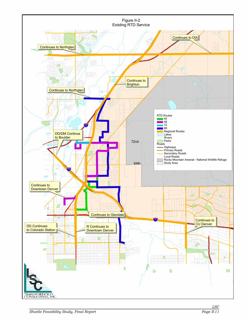
ton in 2015. Figure II-2 provides the current RTD fixed routes in the study area.
Listed below is brief description of each RTD route:
Route 40: Colorado Boulevard, Crosstown
Route 40 provides service from the Southmoor light rail station to Commerce City
from 4:00 a.m. to 2:00 a.m Monday through Friday with 24-hour service on
Saturday and Sunday. The route primarily traverses Colorado Avenue with service
provided in Commerce City along portions of Dahlia, 60th, Holly, and 56th. Places
of interest along the route are City Park, Colorado Center, Colorado Station, the
Denver Museum of Nature and Science, the Denver Zoo, National Jewish Hospital
Rose Medical Center, and Veterans Hospital.
Route 43: Martin Luther King Boulevard/Gateway
Route 43 provides service from the 30th and Downing Street light rail station to the
Stapleton Transfer Center and Northfield Stapleton. Service operates 24 hours per
day seven days a week.
Route 48: East 48th Avenue/Commerce City
Route 48 provides transit service from Downtown Denver to Commerce City end-
ing at the Adams County Social Services complex. Service operates from approxi-
mately 4:30 a.m. to 11:30 p.m. Monday through Friday. Saturday service operates
from approximately 5:00 a.m. to 11:30 p.m. with Sunday service starting at 5:00
a.m. but ending at approximately 10:30 p.m. In Commerce City, the route pri-
marily follows East 72nd.
���� �
������
���� �������������������
������������ �������� �����
���������������������
����������������������������
��������������� �����
� �������������������
��������������������
�������������� �������� �����
����
����
������������� ��
���������������������
��������!�"#��������$ ������%�
����&�������%'&�����������������!���������(���)����)���
�����*�����&�+��,��&��������%�����&������-�%�������
+��'�������-�'��
�$ ��������.�/��//��������������
LSC
Shuttle Feasibility Study, Final Report Page II-11

Evaluation of Current Conditions
LSC
Page II-12 Shuttle Feasibility Study, Final Report
Route 72: 72nd Avenue Crosstown
Route 72 provides transit service from Arvada to Commerce City via Westminister.
Service hours are from approximately 5:15 a.m. to 9:15 p.m. Monday through
Friday with Saturday service from approximately 8:45 a.m. to 6:45 p.m. There is
no Sunday service on this route.
Route 88: Northglenn/Commerce City/Stapleton
Route 88 provides transit service from the Stapleton Transfer Station to the Mar-
ketplace at Northglenn. The route travels on Quebec, East 56th, Holly, East 58th,
Dahlia, East 60th, and Monaco in the Commerce City/Stapleton area. Hours of
operation are 4:44 a.m. to 11:45 p.m. daily. Places of interest along this route are
the US Postal Service General Mail Facility in Commerce City, the Mile High Flea
Market, Northglenn Marketplace, Quebec Square, and the Stapleton Transfer
Station.
Adams County Community Transit (A-Lift)
A-Lift provides accessible and affordable door-to-door public transportation to
older adults and persons with mobility impairments. The service transports these
individuals to medical and dental appointments, grocery shopping, meal sites, and
community-based care programs. Rides are available from 6:00 a.m. to 6:00 p.m.
Monday through Friday. A-Lift does not charge a fare, but accepts donations from
customers using the service. The suggested donation is $5.00 per trip, but no one
is refused a trip if they cannot make this donation. The service is by reservation
only, and it is suggested that an individual reserve a ride at least two to three
working days in advance of their trip with some trips being reserved two weeks in
advance. A-Lift serves the communities of Adams County, Arvada, Commerce City,
Federal Heights, Northglenn, Thornton, and Westminster. These communities also
provide funding for A-Lift, which receives federal and state funding as well.
EXISTING TRAILS
Figure II-3 provides the existing trail network within the area. Future transit route
options will take into consideration the connections to the trail network.

§̈¦76
§̈¦70
§̈¦270
¬«2
tu85
§̈¦470
¬«85
Rocky Mountain AresenalNational Wildlife Refuge
2
Potomac
64th
Tow
er
48th
Qu
ebe
c
120th
Ch
amb
ers
88th
96th
Buc
kle
y
Mon
aco
72nd
PenaH
ava
na
Trails
Proposed
Existing
Rivers
Lakes
Parks
Study Area
Figure II-3Study Area Trails
LS
C
Sh
uttle
Fea
sib
ility S
tud
y, F
ina
l Report
Pa
ge II-1
3

Chapter III

LSC
Shuttle Feasibility Study, Final Report Page III-1
CHAPTER III
Key Person Interviews
INTRODUCTION
The purpose of this chapter is to present an summary of the key person interviews
conducted during the weeks of July 7, July 21, and July 28, 2008. Key person
interviews are part of the public input plan being used in this study. LSC—with
support and input from the City of Commerce City and Stapleton—developed a list
of individuals that represent private and governmental agencies who may be
interested in shuttle transit service in the community.
LSC has interviewed twelve of the thirteen individuals selected to be interviewed.
The individuals interviewed are key decision makers in the community and repre-
sent private business, local government, and civic and business organizations. The
interviews were conducted by telephone. Each person was asked the same ques-
tions and given the opportunity to provide additional insight or information. Below
is a summary of their comments.
Question 1: In your opinion, what are the major issues facing Commerce City, theStapleton area, and the Rocky Mountain Arsenal National Wildlife Refuge?
Answer: All but three of the twelve individuals interviewed expressed that trans-
portation was the major issue facing the study area. Listed below are their specific
answers:
• The biggest issue I see is developing the ways and means to provide access tothe new venues being developed in the area. I believe that the existing infra-structure will not be able to handle the boom in population and the boom inthe amount of visitors from out-of-town coming into the area to enjoy the newvenues.
• I believe that transportation is the major issue facing the area. Whereas theArsenal is a tremendous asset to the community, it presents a challenge inthat it creates a substantial barrier to north-south traffic movement. Also, oncethe Wildlife Refuge opens totally to the public, there will be added traffic ontoroads not equipped to handle the traffic volume created by the Refuge.

Key Person Interviews
LSC
Page III-2 Shuttle Feasibility Study, Final Report
• I believe the major issue facing the area is how to make the Arsenal, CommerceCity, and Stapleton more accessible to members of the community and visitorsto the community.
• I believe the major issue facing the area is the slow development at PrairieGateway.
• I believe that transportation improvement, both transit and highway, is thebiggest issue facing the area. Improvements need to be made on the QuebecAvenue/I-70 interchange, expanded transit routes, and improved pedestrianand bicycle access. Pedestrian and bicycle facilities that allow for the safecrossing of I-70 are also needed.
• The major issue facing the area is transportation, with connectivity of bothtransit and highway services being the top priority.
• The major issue facing the area is transportation, especially the issue of limitednorth-south connections.
• I believe the major issue facing the area is the slow economy that hashampered the residential and retail construction industry.
• I believe the major issue facing the area is connectivity between the CommerceCity core and the Northern Range.
• The connectivity of the roadway network and the negative impact the non-connectivity imposes on future development.
Question 2: In your opinion, what are the major transportation issues facing thearea?
Answer: Since only three persons did not list transportation as the major issue
facing the area, this question was rarely asked. The three people who did not list
transportation as the major issue answered this question by stating that the major
transportation issue facing the area is the lack of local public transportation to the
Arsenal, the Commerce City Civic Center, and the soccer field complex.
Question 3: What, in your opinion, are the needs of the area for local and regionaltransit service?
Answer: All respondents believed that there is a need for expanded service in the
study area. Specific areas for expansion mentioned were:
• Light rail to the area
• Service to the Arsenal
• Dick’s Sporting Goods Park and soccer complex
• Northeast Commerce City

Key Person Interviews
LSC
Shuttle Feasibility Study, Final Report Page III-3
• Commerce City Civic Center
• More bus service frequency
Question 4: What benefits do you think improved transit service would bring to thearea?
Answer: The individuals interviewed all believed that improved transit service
would enhance the vitality of the area, increase residential development, increase
retail development, improve access to Downtown Denver, and allow alternative
access to the community.
Question 5: Does the current transit service meet those needs?
Answer: All individuals interviewed answered no.
Question 6: What areas should be given priority for local transit service?
Answer: The overwhelming response to this question included the Commerce City
Civic Center, Dick’s Sporting Goods Park, and the Arsenal. Specifically, the inter-
viewees wished to connect these facilities to the entire study area.
Question 7: What changes would you like to see in the current transit service?
Answer: The answers to this question were service to the areas mentioned in
Question 6 and expanded service to the entire study area so that transit could
become a viable alternative to the private automobile. One person interviewed also
stated the need for RTD to begin the Transit Oriented Development (TOD) project
at Central Park Boulevard and Smith Road.
Question 8: What should be the hours and days of service?
Answer: Most respondents wished to see service operate seven days a week from
early in the morning to late at night. Several respondents were not sure on the
hours that transit should operate, but they all stated that the service should

Key Person Interviews
LSC
Page III-4 Shuttle Feasibility Study, Final Report
operate seven days a week. Listed below are specific days and times that were
mentioned:
• From 5:00 a.m. to 11:00 p.m. Monday through Thursday and from 5:00 a.m.to midnight Friday, Saturday, and Sunday.
• 5:00 a.m. to 8:00 p.m. seven days a week.
• 6:00 a.m. to 6:00 p.m. Monday through Friday.
• 5:00 a.m. to 11:00 p.m. seven days a week.
• 24 hours a day just like the roadway network.
• What they are for the RTD service.
• 5:00 a.m. to 10:00 p.m. Monday through Saturday and 6:00 a.m. to 9:00 p.m.on Sunday.
Question 9: What do you think would make transit service succeed in your com-munity?
Answer: This question elicited a number of comments which are listed below.
• More residential and retail development that would increase the populationdensity of the area and make public transit more enticing.
• Two respondents stated that a marketing plan is needed with an aggressiveadvertising campaign that establishes a clear picture of how the service oper-ates and where it goes in the community. There is also a need to establishbrand recognition, work with the private and public sectors to develop promo-tional material, and develop a public relations campaign to go out to the com-munity and explain the new service at senior centers, schools, community ser-vice organizations, and churches.
• Efficient and effective day-to-day service that people can rely on.
• Three respondents stated that success relied on an expanded service area andfrequent service to help make the transit service more attractive to peopleriding in cars.
• Ease of use for young families with buses having a storage area for strollers.The buses should be equipped with bike racks and run on some form of alter-native fuel. There should be strategies developed for providing shuttle serviceto soccer games and special events.
• Continued emphasis on increased use of the Commerce City park-and-ride lot,sidewalk development in central Commerce City, and more bus stops andshelters along the existing Commerce City routes.
• I believe that the area needs to reach higher population densities before transitcan succeed.

Key Person Interviews
LSC
Shuttle Feasibility Study, Final Report Page III-5
Question 10: What do you think is the greatest barrier to enhanced public transit inthe community?
Answer: Six respondents felt that funding would be the greatest barrier, two
people believed that the slow economy now being experienced would stop the
growth of transit in the area, one person believed that local government presented
the greatest barrier, one person felt that the geographical location of the Rocky
Mountain Arsenal National Wildlife Refuge was the greatest barrier since it limited
access to major sections of Commerce City, and two respondents felt that RTD was
the greatest barrier to enhanced public transit in that the agency was not
responsive to local needs outside of Denver.
Question 11: What changes would you like to see in the current roadway network?
Answer: There was much discussion on construction of an interchange at I-70 and
Central Park Boulevard. Listed below are the responses to this question:
• Improve the I-70/I-270 interchange. Other than that I believe we have a goodroadway network.
• Widening of Quebec Avenue between Stapleton and Lowry, improvements topedestrian and bicycle access at the Quebec/I-70 interchange, a more exten-sive bicycle and pedestrian trail network, and an interchange at I-70 andCentral Park Boulevard.
• I-70/Central Park Boulevard interchange, extension of Central Park Boulevardnorth of I-70, additional lanes on 56th Avenue, and have Martin Luther KingBoulevard extended to Fitzsimmons Road.
• An I-70/Central Park Boulevard interchange. This is essential for the con-tinued growth of the Stapleton area. We also need a safe crossing of I-70 forbicycles and pedestrians.
• Improvements to the Quebec Avenue/I-70 interchange.
• The completion of the I-70/Central Park Boulevard interchange and the exten-sion of Central Park Boulevard to 60th Street.
• Widening of 56th Street, construction of an interchange at Central Park Bou-levard and I-70, and extending Central Park Boulevard to 60th.
• Improve the signals along State Highway 2, 60th, and Dahlia. Widen 56th andQuebec.
• Construct an interchange at I-70 and Central Park Boulevard, make improve-ments to the I-70/I-270 interchange, make improvements to the I-70/Quebecinterchange, and widen I-70.

Key Person Interviews
LSC
Page III-6 Shuttle Feasibility Study, Final Report
• Construction of an interchange at I-70 and Central Park Boulevard, makeimprovements to the I-70/Quebec interchange, and widen I-70.
Question 12: What areas should be given priority for highway and roadway improve-ment?
Answer: The purpose of this question was to help develop a priority list of highway
and roadway improvements. From the responses above, the priority list appears
to be:
• An interchange at Central Park Boulevard and Interstate 70.
• The extension of Central Park Boulevard north of I-70.
• Improvements to the Quebec/I-70 interchange to provide better north-southaccess of Quebec to pedestrians and cyclists.
• Widening of I-70.
Question 13: What areas should be given priority for pedestrian and bikewayimprovement?
Answer: From several responses to Question 11 and the responses to this ques-
tion, the top priority is for a safe pedestrian and cyclist crossing of Interstate 70.
Other priorities given were:
• Bike trails in the Sand Creek Greenway with access from Stapleton.
• Pedestrian and bike lanes along the Quebec, Havana, and Smith Road cor-ridors.
• Pedestrian and bike lanes along the Central Park Boulevard corridor.
Question 14: Do you think that the community would support increased funding toimprove public transportation services to the Rocky Mountain Arsenal NationalWildlife Refuge? If so, what type of funding should be used?
Answer: The majority of respondents to this question indicated a belief that the
community would not support increased funding to improve public transportation
in the study area. Two respondents were unsure but doubtful, one respondent
stated emphatically that the community would not support this idea, most stated
that with the poor economy being experienced that most folks could not afford
paying additional taxes, and one stated that the community lacks faith in RTD.

Key Person Interviews
LSC
Shuttle Feasibility Study, Final Report Page III-7
Question 15: Are there specific issues which should be addressed in our Shuttle Fea-sibility Study for the Rocky Mountain Arsenal National Wildlife Refuge, CommerceCity, and Stapleton Area?
Answer: Several issues were brought up by the respondents:
1. A request that the consultant develop service hours that are reflective of com-munity needs.
2. The consultant needs to address the benefits of a circulator service and stressthe development of a marketing plan for the new service.
3. Make sure that the alternatives developed for the shuttle service have levelsthat depict minimum, moderate, and exceptional service so that the new ser-vice may be instituted in phases.
Question 16: Is there anyone else we should be interviewing? Public officials? TheChamber? Private individuals?
Answer: Three individuals were recommended to be interviewed.
Question 17: Do you have any other comments?
No one wished to add any comments.
SUMMARY
In total, there was a real interest in enhancing public transportation in the Com-
merce City, Rocky Mountain Arsenal National Wildlife Refuge, and Stapleton area.
It was shared by the respondents that a good transit system would yield many
positive benefits to the community. Unfortunately, excellent transit service comes
at a price to the community and most of the respondents felt that the community
was not willing to pay that price at this time. However, since these responses came
from the point of view that the poor economy would hold back the community’s
willingness to provide funding, this attitude may change once the economy
improves.
The respondents were also quite clear that transit service needs to be provided to
the Rocky Mountain Arsenal National Wildlife Refuge, the Commerce City Civic
Center, and the Dick’s Sporting Goods Park and soccer complex. Since these sites
are relatively close together, it may be a possibility that transit service could begin
to serve these sites as well as traversing through the rest of Commerce City and

Key Person Interviews
LSC
Page III-8 Shuttle Feasibility Study, Final Report
Stapleton to afford local accessibility to these sites. The respondents were also
quite clear on needed roadway improvements which mainly centered around
constructing an interchange at the I-70 and Central Park Boulevard intersection
and the extension of Central Park Boulevard north of I-70. Although the indi-
viduals interviewed do not statistically represent the community at large, they
were nearly unanimous in their priorities for transit and roadway improvements.

Chapter IV

LSC
Shuttle Feasibility Study, Final Report Page IV-1
CHAPTER IV
Transit Demand Assessment
INTRODUCTION
The need to estimate service demand is important in terms of determining capac-
ity, service design, schedules, performance, and revenue. This section outlines
various factors of transit demand, such as:
• Market Segment Populations• Greatest Transit Needs• Existing Ridership• Activity Centers• Recreation Demand• Stakeholder Needs
Each of these factors help to show the patterns that are likely to arise regarding
transit within the area. Estimating demand for services is not an “exact science”
and therefore must be carefully judged for reasonableness. Across the country,
transit use remains a relatively low proportion of overall passenger travel com-
pared to the use of the personal automobile. Average use for transit, where it
exists, represents approximately one percent of the total travel mode split. There-
fore, travel demand for transit continues to remain a very small portion of the total
regional travel.
MARKET SEGMENTS
Current Population
Figure IV-1 shows the current population estimates for the study area by block
group for 2008. It is estimated that since the year 2000, the study area has grown
by 35,882 residents, an increase of slightly over 53 percent. The estimates show
that Adams County has grown at a significantly faster rate than Denver County,
with the exception of Stapleton, but both have seen substantial growth since
2000. The population of the study area is densest in the census block groups that
border East 56th Avenue and slightly less dense but still significant populations
living in the rest of Montbello and the urban core of Commerce City.

�����
����
���� ��
����
����
�� � �
����
����
�������
����� �
��� �
� �
����
���
�����
������
�����
����� �� !������"#����� $���%�������& #���
�����"#����� $���%�������& #�����!�'(����% �#�#�% ��#)���'(����!���(����% �#�#�% ��#)�����(����!��'(����% �#�#�% ��#)����'(����!��'(����% �#�#�% ��#)���*�� ������'(����% �#�#�% ��#)���
+�� �#�������#��������,��$#+ ��$����,��$#
LSC
Page IV-2 Shuttle Feasibility Study, Final Report

Transit Demand Assessment
LSC
Shuttle Feasibility Study, Final Report Page IV-3
Household Density
To evaluate the transit demand for future services, it is necessary to identify those
areas which have the greatest potential for ridership. Criteria used in determining
where transit service should be provided include localities within the transit ser-
vice area which have the highest densities of persons per acre and households per
acre. Nationally, many communities agree that a “high density” of persons is
defined as greater than 12 persons per acre, while a housing density supportive
of fixed-route transit is typically seen as greater than six households per acre. The
combined densities of population and housing provide a baseline picture of where
transit services are likely to be most efficient. A map of the households by density
is shown in Figure IV-2. The western section of Montbello is very densely popu-
lated, and there is a fair amount of density within Commerce City as well. The
outlying regions have sparse amounts of housing within a large geographic region,
making them less dense.
Low-Income Population
Figure IV-3 reflects the 2007 estimated density for the low-income population in
the Commerce City service area based on census block group boundaries. The
low-income population as defined by the FTA is a person whose household income
is at or below the Department of Health and Human Services’ poverty guidelines.
The low-income population used in the tables and maps includes those indi-
viduals who are living below the poverty line using the Census Bureau’s poverty
threshold. The low-income population is most heavily concentrated in the neigh-
borhoods that are located in the northwest corner of Montbello and bordering the
Arsenal and State Highway (SH) 2 in Commerce City. The low-income population
is an important factor in estimating transit demand. Low-income individuals
usually do not possess enough disposable income to purchase a vehicle, meaning
that public transit is often their only option for transportation.

�����
����
���� ��
����
����
�� � �
����
����
�������
����� �
��� �
� �
����
���
�����
������
�����
��������� ������ ������ �!�������" ����� �� ����������" ����� #�� ��������������" �����
$�� ����%�������������&����$ �������&����
'�%�� �() ����� ������ ����
LSC
Page IV-4 Shuttle Feasibility Study, Final Report

�����
����
����� �
����
����
�� � �
����
����
�������
����� �
��� �
� �
����
���
�����
������
�����
����� �� !"# $�����%�&��!���� �� �$�$
�����# $�����%�&��!���� �� �$�$��!�'��( �$�$�( ��$)���� '��!�����( �$�$�( ��$)���� ����!�*���( �$�$�( ��$)���� *���!��+����( �$�$�( ��$)���� ,�� ������+����( �$�$�( ��$)����
-�� �$�������$��������.��/$- ��/����.��/$
LSC
Shuttle Feasibility Study, Final Report Page IV-5

Transit Demand Assessment
LSC
Page IV-6 Shuttle Feasibility Study, Final Report
Mobility-Limited Population
Figure IV-4 presents the 2007 estimated region’s mobility-limited population in
terms of people per square mile density. An individual is classified as “mobility-
limited” if they are between the ages of 16-64 years and identify themselves as
having some form of mobility impairment that restricts their travel outside the
home. The concentration of individuals with mobility limitation is fairly evenly
spread throughout the residential pockets of the study area. The greatest density
of mobility-limited individuals is a small block group bordered by Peoria Street in
the Montbello neighborhood. There are also a fair number of mobility-limited indi-
viduals living in the rest of the Montbello neighborhood and also in the census
block groups surrounding SH 2 in Commerce City. Mobility-limited individuals are
often unable to drive. This population is thus highly reliant on good public transit
systems. A high percentage of people with mobility impairments use public transit
on a frequent basis.
Zero-Vehicle Households
Figure IV-5 presents the 2007 density of the region’s zero-vehicle households in
terms of people per square mile. A zero-vehicle household is defined as a household
in which an individual does not have access to a vehicle. These individuals are
generally transit-dependent as their access to private automobiles is limited.
Zero-vehicle households are concentrated in the southwest corner of the Montbello
neighborhood and the area between East 56th and East 64th Avenues in Commerce
City. Households that lack access to a private automobile must rely on other trans-
portation options. Most often, this means the utilization of public bus and rail, as
it provides a cost advantage over taxicabs and a temporal advantage over walking/
biking.

�����
����
���� ��
����
����
�� � �
����
����
�������
����� �
��� �
� �
����
���
�����
������
�����
����� �� !"# $�����%�&�������!'���� (�� �$�$
�����# $�����%�&�������!'���� (�� �$�$��!�)��* �$�$�* ��$+���� )��!�����* �$�$�* ��$+���� ����!�"���* �$�$�* ��$+���� "���!��,����* �$�$�* ��$+���� &�� ������,����* �$�$�* ��$+����
-�� �$�������$��������.��($- ��(����.��($
LSC
Shuttle Feasibility Study, Final Report Page IV-7

�����
����
���� ��
����
����
�� � �
����
����
�������
����� �
��� �
� �
����
���
�����
������
�����
����� �� !"# $�����%�& ��� ���� ����$ ���'$
�����# $�����%�& ��� ���� ����$ ���'$��!�"�����'$�( ��$)���� "��!��������'$�( ��$)���� ����!�*������'$�( ��$)���� *���!��+�������'$�( ��$)���� ,�� ������+�������'$�( ��$)����
-�� �$�������$��������.��'$- ��'����.��'$
LSC
Page IV-8 Shuttle Feasibility Study, Final Report

Transit Demand Assessment
LSCShuttle Feasibility Study, Final Report Page IV-9
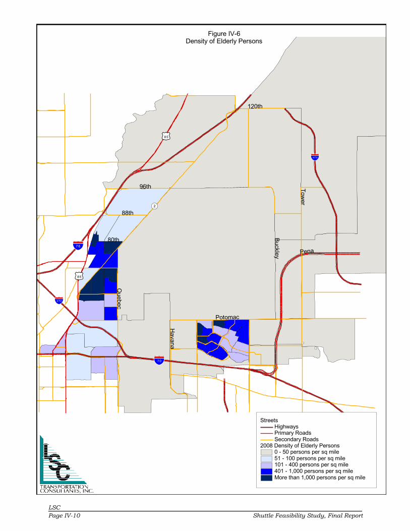
Elderly Population
Figure IV-6 presents the 2007 estimated density of the region’s elderly population
in terms of people per square mile. The elderly population includes individuals over
the age of 60 years. The highest concentration of the elderly within the study area
is a pocket within Commerce City that is bordered by East 62nd Avenue on the
south, Monaco Street on the east, and SH 2 on the west and north. There are also
high concentrations of elderly individuals in the Montbello neighborhood and to the
west of SH 2. Elderly populations often do not have the financial means to own a
car or have lost their ability to drive. Elderly individuals are thus heavily transit-
dependent in many instances.
Future Population Growth
It is important to examine the current trends and predict population growth within
the region so that the transit system does not become outdated quickly. Using US
Census data from 2000 and Denver Regional Council of Governments (DRCOG)
estimates for 2008, the population for each census block was calculated based on
these rates for the year 2020. Since the study area comprises two separate
counties, different growth rates were calculated for the census blocks that are in
each county. In addition, a separate growth was estimated for Stapleton. The
growth rate for Adams County is estimated at 31 percent, while the growth rate for
Denver County is approximately 14 percent. The results of these forecasts can be
seen in Figure IV-7.
The projections show an increase of nearly 40,000 residents in the study area over
the next 12 years. The majority of this growth is projected to take place in Com-
merce City and Stapleton, as much of the other land is either preserved or used for
industry. This is a dramatic increase in population that will put a strain on the
current transportation infrastructure that can be ameliorated with good public
transit.
�����
����
����� �
����
����
�� � �
����
����
�������
����� �
��� �
� �
����
���
�����
������
�����
����� �� !�" #�����$�%�& ����� �#�#
�����" #�����$�%�& ����� �#�#��!�'��( �#�#�( ��#)���� '��!�����( �#�#�( ��#)���� ����!�*���( �#�#�( ��#)���� *���!��+����( �#�#�( ��#)���� ,�� ������+����( �#�#�( ��#)����
-�� �#�������#��������.��&#- ��&����.��&#
LSC
Page IV-10 Shuttle Feasibility Study, Final Report

�����
����
����� �
����
����
�� � �
����
����
�������
����� �
��� �
� �
����
���
�����
������
�����
��������� �� ������������ !�����"�#$����� �!�!�� ��!%���#$����"���$����� �!�!�� ��!%�����$����"��#$����� �!�!�� ��!%����#$����"��#$����� �!�!�� ��!%���&�� ������#$����� �!�!�� ��!%���
'�� �!��(����!��������)���!' �������)���!
*�(�� �+,"-��������� �� ������������ !���
LSC
Shuttle Feasibility Study, Final Report Page IV-11

Transit Demand Assessment
LSC
Page IV-12 Shuttle Feasibility Study, Final Report
GREATEST TRANSIT NEED INDEX
“Greatest transit need” is defined as those areas in the Commerce City service area
with the highest density of zero-vehicle households, minority population, elderly
population, and disabled population. These populations are generally considered
those individuals that have the greatest need for public transit services.
Methodology
US Census data were used to calculate the greatest transit need index. The cate-
gories used for the calculation were zero-vehicle households, elderly population,
disabled population, and below-poverty population. Using these categories, LSC
developed a “transit need index” to determine the areas with the greatest transit
need. The density of the population for each US Census Block Group within each
category was calculated, placed in numerical order, and divided into six segments.
Six segments were chosen in order to reflect a reasonable range. Each segment
contained an approximately equal number of US Census Block Groups in order to
provide equal representation.
Census block groups in the segment with the lowest densities were given a score
of 1. The tracts in the segment with the next lowest densities were given a score of
2. This process continued for the remainder of the block groups. The census block
groups in the segment with the highest densities were given a score of 6. This
scoring was completed for each of the categories (zero-vehicle households, elderly
population, disabled population, and below-poverty population). After each of the
census block groups was scored for the four categories, the four scores were added
to achieve an overall score. Table IV-1 presents the rank for each census block
group in the Commerce City study area. The scores range from 4 (lowest need) to
24 (highest need).
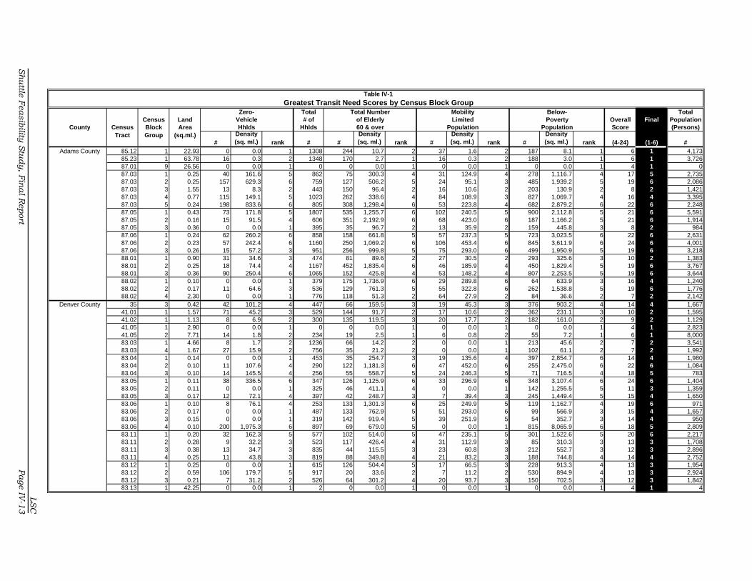
Zero- Total TotalCensus Land Vehicle # of Overall Final Population
County Census Block Area Hhlds Hhlds Score (Persons)Tract Group (sq.ml.)
#Density (sq. ml.) rank # #
Density (sq. ml.) rank #
Density (sq. ml.) rank #
Density (sq. ml.) rank (4-24) (1-6) #
Adams County 85.12 1 22.93 0 0.0 1 1308 244 10.7 2 37 1.6 2 187 8.1 1 6 1 4,17385.23 1 63.78 16 0.3 2 1348 170 2.7 1 16 0.3 2 188 3.0 1 6 1 3,72687.01 9 26.56 0 0.0 1 0 0 0.0 1 0 0.0 1 0 0.0 1 4 1 087.03 1 0.25 40 161.6 5 862 75 300.3 4 31 124.9 4 278 1,116.7 4 17 5 2,73587.03 2 0.25 157 629.3 6 759 127 506.2 5 24 95.1 3 485 1,939.2 5 19 6 2,08687.03 3 1.55 13 8.3 2 443 150 96.4 2 16 10.6 2 203 130.9 2 8 2 1,42187.03 4 0.77 115 149.1 5 1023 262 338.6 4 84 108.9 3 827 1,069.7 4 16 4 3,39587.03 5 0.24 198 833.6 6 805 308 1,298.4 6 53 223.8 4 682 2,879.2 6 22 6 2,24887.05 1 0.43 73 171.8 5 1807 535 1,255.7 6 102 240.5 5 900 2,112.8 5 21 6 5,59187.05 2 0.16 15 91.5 4 606 351 2,192.9 6 68 423.0 6 187 1,166.2 5 21 6 1,91487.05 3 0.36 0 0.0 1 395 35 96.7 2 13 35.9 2 159 445.8 3 8 2 98487.06 1 0.24 62 260.2 6 858 158 661.8 5 57 237.3 5 723 3,023.5 6 22 6 2,63187.06 2 0.23 57 242.4 6 1160 250 1,069.2 6 106 453.4 6 845 3,611.9 6 24 6 4,00187.06 3 0.26 15 57.2 3 951 256 999.8 5 75 293.0 6 499 1,950.9 5 19 6 3,21888.01 1 0.90 31 34.6 3 474 81 89.6 2 27 30.5 2 293 325.6 3 10 2 1,38388.01 2 0.25 18 74.4 4 1167 452 1,835.4 6 46 185.9 4 450 1,829.4 5 19 6 3,76788.01 3 0.36 90 250.4 6 1065 152 425.8 4 53 148.2 4 807 2,253.5 5 19 6 3,64488.02 1 0.10 0 0.0 1 379 175 1,736.9 6 29 289.8 6 64 633.9 3 16 4 1,24088.02 2 0.17 11 64.6 3 536 129 761.3 5 55 322.8 6 262 1,538.8 5 19 6 1,77688.02 4 2.30 0 0.0 1 776 118 51.3 2 64 27.9 2 84 36.6 2 7 2 2,142
Denver County 35 3 0.42 42 101.2 4 447 66 159.5 3 19 45.3 3 376 903.2 4 14 4 1,66741.01 1 1.57 71 45.2 3 529 144 91.7 2 17 10.6 2 362 231.1 3 10 2 1,59541.02 1 1.13 8 6.9 2 300 135 119.5 3 20 17.7 2 182 161.0 2 9 2 1,12941.05 1 2.90 0 0.0 1 0 0 0.0 1 0 0.0 1 0 0.0 1 4 1 2,82341.05 2 7.71 14 1.8 2 234 19 2.5 1 6 0.8 2 55 7.2 1 6 1 8,00083.03 1 4.66 8 1.7 2 1236 66 14.2 2 0 0.0 1 213 45.6 2 7 2 3,54183.03 4 1.67 27 15.9 2 756 35 21.2 2 0 0.0 1 102 61.1 2 7 2 1,99283.04 1 0.14 0 0.0 1 453 35 254.7 3 19 135.6 4 397 2,854.7 6 14 4 1,98083.04 2 0.10 11 107.6 4 290 122 1,181.3 6 47 452.0 6 255 2,475.0 6 22 6 1,08483.04 3 0.10 14 145.5 4 256 55 558.7 5 24 246.3 5 71 716.5 4 18 5 78383.05 1 0.11 38 336.5 6 347 126 1,125.9 6 33 296.9 6 348 3,107.4 6 24 6 1,40483.05 2 0.11 0 0.0 1 325 46 411.1 4 0 0.0 1 142 1,255.5 5 11 3 1,35983.05 3 0.17 12 72.1 4 397 42 248.7 3 7 39.4 3 245 1,449.4 5 15 4 1,65083.06 1 0.10 8 76.1 4 253 133 1,301.3 6 25 249.9 5 119 1,162.7 4 19 6 97183.06 2 0.17 0 0.0 1 487 133 762.9 5 51 293.0 6 99 566.9 3 15 4 1,65783.06 3 0.15 0 0.0 1 319 142 919.4 5 39 251.9 5 54 352.7 3 14 4 95083.06 4 0.10 200 1,975.3 6 897 69 679.0 5 0 0.0 1 815 8,065.9 6 18 5 2,80983.11 1 0.20 32 162.3 5 577 102 514.0 5 47 235.1 5 301 1,522.6 5 20 6 2,21783.11 2 0.28 9 32.2 3 523 117 426.4 4 31 112.9 3 85 310.3 3 13 3 1,70883.11 3 0.38 13 34.7 3 835 44 115.5 3 23 60.8 3 212 552.7 3 12 3 2,89683.11 4 0.25 11 43.8 3 819 88 349.8 4 21 83.2 3 188 744.8 4 14 4 2,75283.12 1 0.25 0 0.0 1 615 126 504.4 5 17 66.5 3 228 913.3 4 13 3 1,95483.12 2 0.59 106 179.7 5 917 20 33.6 2 7 11.2 2 530 894.9 4 13 3 2,92483.12 3 0.21 7 31.2 2 526 64 301.2 4 20 93.7 3 150 702.5 3 12 3 1,84283.13 1 42.25 0 0.0 1 2 0 0.0 1 0 0.0 1 0 0.0 1 4 1 4
60 & over Population Populationof Elderly Limited Poverty
Table IV-1
Greatest Transit Need Scores by Census Block Group Total Number Mobility Below-
LS
C
Sh
uttle
Fea
sib
ility S
tud
y, F
ina
l Report
Pa
ge IV
-13

Transit Demand Assessment
LSC
Page IV-14 Shuttle Feasibility Study, Final Report
Results
Figure IV-8 presents Commerce City’s census block groups with the greatest
transit need, along with the transit need index. Nine census block groups were
determined to have the greatest transit needs based on the zero-vehicle house-
holds, elderly population, disabled population, and below-poverty population. As
shown in Figure IV-8, the greatest transit need is mainly in the two core residential
areas, in the southeast and northeast sections of Commerce City, and also the
western and northern boundaries of Montbello.
By identifying those areas with a high need for public transportation, LSC was able
to uncover a pattern for the areas with the highest propensity to use transit ser-
vice. Those US Census Block Groups not scoring in the highest category, but still
having a high score, could still be considered a high priority for transit service.
These are the census block groups with an index of either four or five.

�����
����
���� ��
����
����
�� � �
����
����
�������
����� �
��� �
� �
����
���
�����
������
�����
����� �� !�"� �� #�����#���$ %#
"� �� #�����#���$ %#��&���'()������
*�� �#�������#��������+��%#* ��%����+��%#
LSC
Shuttle Feasibility Study, Final Report Page IV-15

Transit Demand Assessment
LSC
Page IV-16 Shuttle Feasibility Study, Final Report
EXISTING RIDERSHIP
Currently there are 1,747 daily boardings at stops served by RTD within the study
area. Conversely, there are 1,711 daily alightings. Boarding and alighting patterns
allow a graphic representation of what the most popular origins and destinations
are for transit users. As shown in Figures IV-9 and IV-10, the majority of users
board buses at 60th and Dahlia Streets. Other stops that record high daily board-
ings are 72nd and Colorado Avenue, as well as the Commerce City park-and-ride.
These locations also recorded some of the highest alightings, showing a near
balance of people getting on and off at these stops.

�
�
�
�� � �� ��
� �� � �� �
����
�
���
� �� ��� � ��
�
�
��� � �
�� � ���
��
�
�
�
�
�
�
�
� ��
�
�
�
������
�����
������
����
����
����
���
�����
���
������
����
����
����
����
������
���
������
� ���� �
����
��� �����
������
����
����
������� �!���"��#���$�����%� ������$�����&� ��$�����
�'�$��������������#�
������� �� ($)$(�� (�$)$�*
� ��$)$(*�
� (*�$)$���
+� ��$,-)������$������� �
LSC
Shuttle Feasibility Study, Final Report Page IV-17

�
�
�
�
�
� � �� ��
� � �� � �� �
����
�
���
� �� ��� � ��
�
�
��� � �
�� � ���
�
�
�
�
�
�
�
�
�
�
� ��
�
�
�
������
�����
������
����
����
����
���
�����
���
������
����
����
����
����
������
���
������
� ���� �
����
��� �����
������
����
����
������� �!���"��#���$�����%� ������$�����&� ��$�����
�'�$����������������
�����$(�� ���� �� )$*$)�� )�$*$�+
� ��$*$)+�
� )+�$*$���
,� ��$-.*)������$(�� ���� �
LSC
Page IV-18 Shuttle Feasibility Study, Final Report

Transit Demand Assessment
LSC
Shuttle Feasibility Study, Final Report Page IV-19
ACTIVITY CENTERS
Figure IV-11 shows the service area with the activity centers labeled. Activity
centers are regional attractions that are primary destinations for the community.
These activity centers vary in scope and tone, and can be related to many different
activities including shopping, recreation, and education.
The activity centers map shows 11 of the region’s primary assets. Since these areas
are the center of activity, they are also presumed to be trip generators for public
transit users. The activity centers in the Commerce City study area are fairly
spread throughout the region. The majority of the activity centers are clustered in
either Commerce City or Montbello. Serving the majority of these activity centers
will produce the most efficient and desirable public transit system.

LS
C
Pa
ge IV
-20
Sh
uttle
Fea
sib
ility S
tud
y, F
ina
l Rep
ort
Transit Demand Assessment
LSC
Shuttle Feasibility Study, Final Report Page IV-21
REFUGE DEMAND
Visitor Demand Estimation
Existing transit forecasting methods are not relevant to potential transportation
systems at public recreation sites, as travelers have different motivations for riding
transit than a typical community-oriented transit system. To provide a quantitative
basis for forecasting demand specific to recreation areas, previous work completed
by LSC and VHB was used to determine the relationship between existing transit
service demand and specific transit and park characteristics. The previous work
collected data from existing passenger transit systems at various public recreation
sites. Results of this data collection effort were analyzed to develop general rider-
ship estimation guidelines.
The final list of recreations sites with applicable transit systems consists of the
following:
• Acadia National Park
• Bryce Canyon National Park
• Cape Cod National Seashore
• Denali National Park
• Reds Meadow/Devils Postpile National Monument
• Grand Canyon National Park
• Harpers Ferry National Historic Park
• Point Reyes National Seashore
• Rocky Mountain National Park
• Yosemite National Park
• Zion National Park
Visitor Data
The NPS Public Use Statistic Office collects and maintains national park statistics.
Recreation visits to each national park are estimated through a combination of
methods including pneumatic tube traffic counters, staff observations or actual
counts, the number of permits issued, and the number of buses passing a check-
point. The exact method of estimation varies at each site.

Transit Demand Assessment
LSC
Page IV-22 Shuttle Feasibility Study, Final Report
Total recreation visitor-days at a site is the estimated number of 12-hour periods
recreation visitors spent at the site. For example, each type of recreation visitor
(overnight, day, backcountry camper) is assigned a length of stay multiplier in
hours specific to the park. Total recreation visitor-hours is the sum of the products
of the length of stay multipliers and types of visitors. This number is generally
divided by 12 to approximate total recreation visitor-days. It should be noted that
the formulas used in specific parks can include other factors and vary between
parks.
For the purpose of the Rocky Mountain Arsenal National Wildlife Refuge, a visitor
day was assumed to be 0.35 which is equivalent to approximately four hours per
visit per person.
Transit Programs
Acadia National Park (ACAD) - Acadia National Park encompasses over 47,000 acres
of land, with a network of roadways passing through the site and to site attrac-
tions. The Island Explorer shuttle program stops at many lodges, activity centers
and campgrounds, as well as nearby communities, linking visitors to destinations
across Mount Desert Island and parts of Acadia National Park. The transit system
consists of eight routes, and automatic passenger counters are used to track rider-
ship. A significant proportion of shuttle passengers (estimated to equal 20 percent)
are local residents.
Bryce Canyon National Park (BRCA) - Bryce is easily accessible by state highway,
with the majority of activities located along a single dead-end roadway. The Bryce
Canyon Shuttle provides an alternative to the private automobile over the non-
winter months, serving a total of 15 stops at no fare to the passenger. Visitors are
encouraged to park and board the shuttle at either the shuttle parking and
boarding area, or at Ruby’s Inn and Campground.
Cape Cod National Seashore (CACO) - Using NPS-owned vehicles, the Cape Cod
Regional Transit Authority operates the Provincetown Shuttle between beaches on
the northern portion of the Cape and the town of Truro.

Transit Demand Assessment
LSC
Shuttle Feasibility Study, Final Report Page IV-23
Denali National Park (Front Country Shuttles) - Denali National Park runs the Front
County Shuttle program as a discretionary alternative to driving private vehicles
along the first 14 miles of the park road.
Grand Canyon National Park (GRCA) - On the South Rim, free voluntary shuttle
service is available year-round throughout Grand Canyon Village, serving a total
of 14 stops.
Rocky Mountain National Park (ROMO) - A shuttle bus program is operated in the
Moraine Park and Bear Lake areas during the peak summer season, serving a total
of 12 stops. On peak days when traffic is congested, the road is closed for two to
three hours and visitors are required to use the shuttle system. As this only occurs
five to ten times each year and the large majority of shuttle ridership is during
these non-mandatory use periods, this program was not considered as a dis-
cretionary system.
Yosemite National Park (YOSE) - The Yosemite Valley Shuttle Bus is operated year-
round, providing service to 21 stops located at lodging facilities, campgrounds,
parking lots, and activity centers across the floor of the Yosemite Valley. Other
seasonal routes are offered, but were not included in the analysis. Limited parking
and high traffic during the peak season make the shuttle an attractive option for
visitors.
The primary objective of the data collection effort was to evaluate the relationship
(based on the data provided by the programs) between the level of visitor activity
and the transit ridership, specifically for the programs that are discretionary to the
visitor. Two data relationships were evaluated:
Annual recreation visitors and annual one-way passenger-trip data were compared.
This study found that the ratio of passenger-trips to recreation visitors (the rate)
for the discretionary programs ranged from a low of 0.06 for the Cape Cod
Provincetown Shuttle to a high of 0.80 for the Yosemite Valley Shuttle. A simple
measure of the correlation between the independent and dependent variable is the
coefficient of determination (R2). The R2 value can range from 0.0 (when none of the

Transit Demand Assessment
LSC
Page IV-24 Shuttle Feasibility Study, Final Report
variation in the dependent variable is explained by the variation in the independent
variable) to 1.0 (when the dependent variable is perfectly correlated to the inde-
pendent variable). The study showed the R2 value between visitors and transit
ridership was calculated to be 0.44, meaning that there is not a high degree of
correlation between transit one-way passenger-trips and the number of visitors at
the sites analyzed. Two parks in particular were considered outliers— Yosemite NP
is the park with the highest number of visits and highest ridership, and Cape Cod
is the park with a high number of visits but low ridership. The best-fit linear
regression line reflects a “rate” of 0.4 one-way transit passenger-trips per visitor.
As the length of stay of a visitor can affect the number of times a person rides the
bus as well as a person’s decision on whether or not to leave their vehicle in a
parking lot, the relationship between annual visitor-days and annual one-way
passenger-trips was also examined. The R2 value was 0.95, indicating a very high
correlation between these two data sets. The best-fit rate reflects 0.5 transit pas-
senger-trips per visitor-day. The observed rate for the various discretionary transit
programs included in the analysis ranges from a low of 0.22 for Rocky Mountain
to a high of 0.54 for the Yosemite and Bryce Canyon programs, followed closely by
the Acadia Island Explorer program.
While the comparison of transit ridership and visitor-days shows a surprisingly
high correlation, it should not be concluded that ridership for a discretionary pro-
gram on recreational lands can be accurately estimated using the resulting rate.
In particular, there is a high degree of uncertainty associated with the lack of
visitor use data specific for the area of each park served by the transit program. In
addition, the fact that capacity of the transit program is reached for all programs
included in the analysis indicates that actual demand could well be greater than
reflected in the ridership data. Providing the data needed to address these factors
would require detailed on-site data collection. Nevertheless, the resulting “rate”—
0.5 annual one-way passenger-trips per annual visitor-days— provides a useful
rule-of-thumb on which to base “first-approximation” estimates of ridership that
would result from a new transit program on federal recreational lands.
Transit Demand Assessment
LSC
Shuttle Feasibility Study, Final Report Page IV-25
Vehicle Occupancy
Vehicles occupancy rates can be used to help determine number of visitors. The
following rates help to confirm those presented in Chapter II.
• The average vehicle occupancy rate in Mesa Verde National Park is 3.2 personsper vehicle (Field Report Mesa Verde National Park by Federal Highway Admin-istration and Federal Transit Administration, date unknown).
• The average vehicle occupancy in the Cades Cove portion of Great SmokyMountains National Park was found in 1998 to be 2.7 in August and 2.3 inOctober (Cades Cove Technology Assessment Final Report, Great SmokyMountain National Park, by Wilbur Smith Associates, August 2001).
• At the South Rim of Grand Canyon National Park in 2000, the average pas-senger group size was 3.3 people (Final Environmental Assessment MatherPoint Orientation/Transit Center and Transit System, Appendix D, GrandCanyon National Park, Arizona, author unknown, July 1997).
• In Zion National Park, average vehicle occupancy was found to be 2.9 (ZionNational Park Transportation Study and Implementation Plan by Balloffet andAssociates, Inc., November 1995).
• The average size group at the Thurston Lava Tube attraction at HawaiiVolcanoes National Park was 3.5 people (HAVO Visitor Study, Study Com-pletion Report by University of Vermont, August 2003).
Visitor Demand Estimates
Using the ridership demand estimation techniques discussed previously, the visitor
transit demand has been calculated at 7,000 annual one-way trips. This represents
a significant 3.5 percent mode split for all person trips entering the Refuge through
the Visitor Center. This may be a high estimate of ridership; however, it provides
a “sketch plan” estimation using available information. Based upon 100,000
visitors, using a 2.37 vehicle occupancy rate, this represents nearly 42,200 vehicles
entering the area. If transit were to provide 7,000 trips, this would reduce the
traffic by nearly 3,000 vehicles annually to 39,000 vehicles.
Based upon the Prairie Gateway Traffic Impact Study, it is estimated that the
stadium complex parking will generate an average of approximately 5,796 weekday
vehicle trips. Using a one percent mode split for transit, and auto occupancy of one
person per vehicle, this would equate to over 15,000 annual transit trips.

Transit Demand Assessment
LSC
Page IV-26 Shuttle Feasibility Study, Final Report
STAKEHOLDERS’ NEEDS
Through the stakeholder interviews that were outlined in Chapter III, key areas of
need for transit service arose. These key person interviews established a need for
transit service at three specific landmarks, as well as establishing larger service
areas that should be accommodated.
The majority of persons interviewed said that the Dick’s Sporting Goods Park,
Rocky Mountain Arsenal National Wildlife Refuge, and the Commerce City Civic
Center all needed to be served by transit. These three locations are primary desti-
nations for travel.
The interviewees also stated that service was needed from Commerce City to the
Stapleton transfer center in order to access greater transit opportunities. They also
requested that service cross Interstate 70 and access the northeast section of
Commerce City.
CONCLUSION
This section has discussed various characteristics which help to determine demand
for future services. Transit demand is based on many factors, and creating rider-
ship projections is extremely difficult. There are certainly recreation demands for
the area and likely elderly and disabled needs. RTD operations generate nearly 25
transit trips per capita on the fixed routes in the area. Until LSC can meet with
local stakeholders to discuss the routing of a future shuttle route, a quantitative
demand estimation is only a guess. Using five trips per capita would generate
70,000 additional transit trips. The Refuge is estimated to be able to support
approximately 7,000 annual trips. Adding in the addition of the stadium events, a
demand of nearly 15,000 trips could be anticipated. A one-half percent mode split
for the rest of the Prairie Gateway Campus could generate another 100,000 trips
annually, assuming an auto occupancy of one person. Total trip demand could
reasonably be assumed at approximately 130,000 to 150,000 annual one-way
transit trips. The entire Prairie Gateway Campus is anticipated to generate over
88,000 vehicle-trips daily. Using a one percent mode split for this development

Transit Demand Assessment
LSC
Shuttle Feasibility Study, Final Report Page IV-27
would generate over 200,000 transit trips annually, assuming one person per
vehicle.
Specific demand estimates were developed for the service options described in later
chapters.
Chapter V

LSCShuttle Feasibility Study, Final Report Page V-1
CHAPTER V
Service Options
INTRODUCTION
LSC has developed nine service options that provide circulator/shuttle service to
the areas set forth by the Stakeholders Group. As discussed earlier in this report,
the Stakeholders Group developed three priorities of service for Commerce City, the
Rocky Mountain Arsenal National Wildlife Refuge (RMANWR), and the Northfield
Mall/Stapleton area. LSC has developed conceptual route alignments and oper-
ating options for the potential services. Since many of the Priority II and Priority
III destinations are far from other destinations, it was necessary to develop
multiple routes in these phases. The service options also include operational costs
(based on the Regional Transportation District [RTD] estimated hourly operating
cost of $62.00) for providing weekday service only; weekday and weekend service;
60-minute or 30-minute frequency of service; and 6:00 a.m. to 6:00 p.m., 6:00
a.m. to 10:00 p.m., and 24-hour service days. This chapter also discusses some
possible RTD route realignments that may be accomplished to serve the Commerce
City Civic Center, Dick’s Sporting Goods Park, and the Rocky Mountain Arsenal
National Wildlife Refuge.
SERVICE OPTIONS
Service Option 1: Fitzsimons to Commerce City
This option provides regular fixed route service from downtown Commerce City to
the Colorado University Medical Center Complex (Fitzsimons), as illustrated in
Figure V-1. Table V-1 shows the operating characteristics of this service alterna-
tive. Additionally, this service option provides services to the Montbello area, an
area with a great need for services.

Service Options
LSCPage V-2 Shuttle Feasibility Study, Final Report
Priority I Destinations Served
The Priority I destinations served by Route 1 include:
• Wal-Mart
• Commerce City Recreational Center
Priority II Destinations Served
There are no Priority II destinations served.
Priority III Destinations Served
The Priority III destinations served by Route 1 include:
• Middle School on 62nd
• CU Medical Complex

����
��
��
��
��
��
�� ��
��
����
��
����
����� ���
�� ����
�������
�����
������
�����
���
�����
���� ��
�����
������
���������
���� !"������!������
��������!����! ��!������
#�$�����! %&!%������!#�����
��������!����!��'��!������
&��()�!#$�����*!+�� �!��(
�����
�����
,��-������
�� ��!#�����
����!��*�!+������� ! ���*
�����������!.�����!/��*
� ��!����!#����!#��'����
,�*���!"�0 ����!0
��(�!�������!������!�!������!��� ����! ���*���(� �'���.(��
#��������*����������! � �#���� ��! � �1 �$�.���! � �
��
%&! �����2345�44 �*����! �����
����� ����!0,�����! ����!0!6��������
�� ��������!3!#��$��� ��������!�!#��$��� ��������!0!#��$�
�
LSC
Sh
uttle F
easib
ility S
tud
y, F
ina
l Rep
ortPa
ge V-3

Table V-1
Route 1 - Fitzsimons to Commerce City - Service Characteristics
OperatingHours of Service # of Vehicle- Vehicle- Vehicle- Vehicle- Operating Annual Pass. per Cost Cost ($) per
Veh. Miles Hours Miles Hours Days Ridership Hour Annual Pass.WEEKDAY SERVICE
Hourly Service, 6a-6p 2.0 312 24.0 78,000 6,000 250 55,239 9.2 372,000$ $6.73Half-hour Service, 6a-6p 4.0 624 48.0 156,000 12,000 250 109,629 9.1 744,000$ $6.79Hourly Service, 6a-10p 2.0 416 32.0 104,000 8,000 250 66,839 8.4 496,000$ $7.42Half-hour Service, 6a-10p 4.0 832 64.0 208,000 16,000 250 132,652 8.3 992,000$ $7.48Hourly Service, 24 hours/day 2.0 624 48.0 156,000 12,000 250 70,706 5.9 744,000$ $10.52Half-hour Service, 24 hours/day 4.0 1,248 96.0 312,000 24,000 250 140,326 5.8 1,488,000$ $10.60
WEEKEND SERVICEHourly Service, 6a-6p 2.0 312 24.0 32,448 2,496 104 9,192 3.7 154,752$ $16.84Half-hour Service, 6a-6p 4.0 624 48.0 64,896 4,992 104 18,242 3.7 309,504$ $16.97Hourly Service, 6a-10p 2.0 416 32.0 43,264 3,328 104 11,122 3.3 206,336$ $18.55Half-hour Service, 6a-10p 4.0 832 64.0 86,528 6,656 104 22,073 3.3 412,672$ $18.70Hourly Service, 24 hours/day 2.0 624 48.0 64,896 4,992 104 11,765 2.4 309,504$ $26.31Half-hour Service, 24 hours/day 4.0 1,248 96.0 129,792 9,984 104 23,350 2.3 619,008$ $26.51
Note: Costs based on RTD service costs.
Total Daily Revenue Total Annual Revenue
LSC
Pa
ge V-4
Sh
uttle F
easib
ility S
tud
y, F
inal R
eport
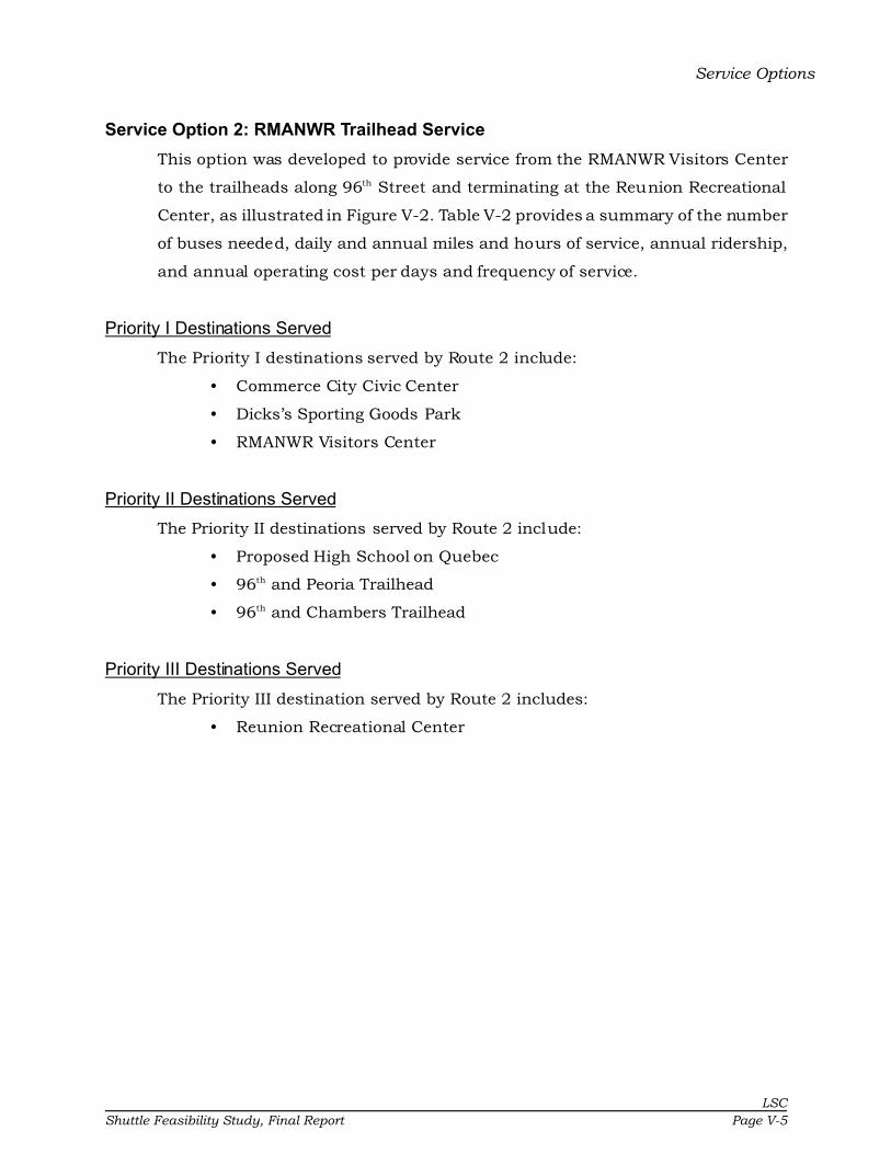
Service Options
LSC
Shuttle Feasibility Study, Final Report Page V-5
Service Option 2: RMANWR Trailhead Service
This option was developed to provide service from the RMANWR Visitors Center
to the trailheads along 96th Street and terminating at the Reunion Recreational
Center, as illustrated in Figure V-2. Table V-2 provides a summary of the number
of buses needed, daily and annual miles and hours of service, annual ridership,
and annual operating cost per days and frequency of service.
Priority I Destinations Served
The Priority I destinations served by Route 2 include:
• Commerce City Civic Center
• Dicks’s Sporting Goods Park
• RMANWR Visitors Center
Priority II Destinations Served
The Priority II destinations served by Route 2 include:
• Proposed High School on Quebec
• 96th and Peoria Trailhead
• 96th and Chambers Trailhead
Priority III Destinations Served
The Priority III destination served by Route 2 includes:
• Reunion Recreational Center

��
�� ��
��
��
��
����
�� ��
��
��
�� ������
����
�����
���
��
���
��
����
���
�����
��������
��������� �����������
���������������������� ��������������������������� ! �"#�����$�%��& �'��
)� ���������&�(�$��"�����
'��#� �&���*�(�$��"�����
+�������& +�������&
����������'���"������"������
(������"�����
��&&���"�����
������������������,�������� �����������
�����(�$��-������� ��
( $��%�������&������$
-�$������.������.
��� ������������� �������������������&��/����/�$�'�� ����� )� �
"����� (�$�*�� '���������& "����&�������& )��������&
����
�+������� ���0�12.11��$�����������
����� ������.
�� '��������0�"��# �� '��������.�"��# �� '����������"��#
�
LS
C
Pa
ge V
-6S
hu
ttle F
ea
sib
ility S
tud
y, F
ina
l Rep
ort

Table V-2
Route 2 - Refuge/Trailheads - Service CharacteristicsOperating
Hours of Service # of Vehicle- Vehicle- Vehicle- Vehicle- Operating Annual Pass. per Cost Cost ($) perVeh. Miles Hours Miles Hours Days Ridership Hour Annual Pass.
WEEKDAY SERVICEHourly Service, 6a-6p 2.0 288 24.0 72,000 6,000 250 12,264 2.0 372,000$ $30.33Half-hour Service, 6a-6p 4.0 576 48.0 144,000 12,000 250 23,998 2.0 744,000$ $31.00Hourly Service, 6a-10p 2.0 384 32.0 96,000 8,000 250 14,840 1.9 496,000$ $33.42Half-hour Service, 6a-10p 4.0 768 64.0 192,000 16,000 250 29,038 1.8 992,000$ $34.16Hourly Service, 24 hours/day 2.0 576 48.0 144,000 12,000 250 15,698 1.3 744,000$ $47.39Half-hour Service, 24 hours/day 4.0 1,152 96.0 288,000 24,000 250 30,718 1.3 1,488,000$ $48.44
WEEKEND SERVICEHourly Service, 6a-6p 2.0 288 24.0 29,952 2,496 104 2,041 0.8 154,752$ $75.83Half-hour Service, 6a-6p 4.0 576 48.0 59,904 4,992 104 3,993 0.8 309,504$ $77.51Hourly Service, 6a-10p 2.0 384 32.0 39,936 3,328 104 2,469 0.7 206,336$ $83.56Half-hour Service, 6a-10p 4.0 768 64.0 79,872 6,656 104 4,832 0.7 412,672$ $85.41Hourly Service, 24 hours/day 2.0 576 48.0 59,904 4,992 104 2,612 0.5 309,504$ $118.48Half-hour Service, 24 hours/day 4.0 1,152 96.0 119,808 9,984 104 5,111 0.5 619,008$ $121.10
Note: Costs based on RTD service costs.
Total Daily Revenue Total Annual Revenue
LS
C
Sh
uttle
Fea
sib
ility S
tud
y, F
ina
l Report
Pa
ge V
-7
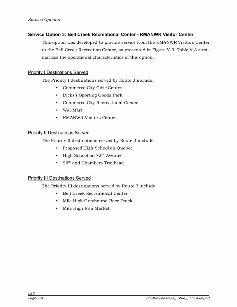
Service Options
LSC
Page V-8 Shuttle Feasibility Study, Final Report
Service Option 3: Bell Creek Recreational Center - RMANWR Visitor Center
This option was developed to provide service from the RMANWR Visitors Center
to the Bell Creek Recreation Center, as presented in Figure V-3. Table V-3 sum-
marizes the operational characteristics of this option.
Priority I Destinations Served
The Priority I destinations served by Route 3 include:
• Commerce City Civic Center
• Dicks’s Sporting Goods Park
• Commerce City Recreational Center
• Wal-Mart
• RMANWR Visitors Center
Priority II Destinations Served
The Priority II destinations served by Route 3 include:
• Proposed High School on Quebec
• High School on 72nd Avenue
• 96th and Chambers Trailhead
Priority III Destinations Served
The Priority III destinations served by Route 3 include:
• Bell Creek Recreational Center
• Mile High Greyhound Race Track
• Mile High Flea Market

��
��
��
��
��
��
����
��
����
��
��
�� ������
����
����
�����
����
��
����
� ������������
�������
�����
���� ��
������
�����
����
��������
��� ��!"������!#����
#�������!#���!���!#���� #�������!#���!#�$��!#����
%��&'�!()�����!*����!+��&
�����!#��!,���!(�����-�����!�����!,���!(�����
+��)����! �.!,���!(�����
/�������� ����!0
#�������!#���!+�
�����!#��!(�����!(��$����
������!(�����
������!(�����
����!#���&!���!#����
����!,���!1���!���&��
����!,���!*����� �!�����
����
�����!#��!(�����!(��$����
1�� ��!"�2�� ��!2
���&�!�� ���!������!�! ������!������3�!��3 ��+��&���$���-�&��
(������,���.���+������!�����(�������!�����-����!�����
����
�/%!�� ������2������������!�� ���
�� ����� ��!2
�� +�������!2!(��)��� +�������!!(��)��� +�������!�!(��)�
�
LS
C
Sh
uttle
Fea
sib
ility S
tud
y, F
ina
l Report
Pa
ge V
-9

Table V-3
Route 3 - Flea Market/Trails/Refuge - Service CharacteristicsOperating
Hours of Service # of Vehicle- Vehicle- Vehicle- Vehicle- Operating Annual Pass. per Cost Cost ($) perVeh. Miles Hours Miles Hours Days Ridership Hour Annual Pass.
WEEKDAY SERVICEHourly Service, 6a-6p 2.0 288 24.0 72,000 6,000 250 33,826 5.6 372,000$ $11.00Half-hour Service, 6a-6p 4.0 576 48.0 144,000 12,000 250 66,514 5.5 744,000$ $11.19Hourly Service, 6a-10p 2.0 384 32.0 96,000 8,000 250 40,929 5.1 496,000$ $12.12Half-hour Service, 6a-10p 4.0 768 64.0 192,000 16,000 250 80,482 5.0 992,000$ $12.33Hourly Service, 24 hours/day 2.0 576 48.0 144,000 12,000 250 43,297 3.6 744,000$ $17.18Half-hour Service, 24 hours/day 4.0 1,152 96.0 288,000 24,000 250 85,138 3.5 1,488,000$ $17.48
WEEKEND SERVICEHourly Service, 6a-6p 2.0 288 24.0 29,952 2,496 104 5,629 2.3 154,752$ $27.49Half-hour Service, 6a-6p 4.0 576 48.0 59,904 4,992 104 11,068 2.2 309,504$ $27.96Hourly Service, 6a-10p 2.0 384 32.0 39,936 3,328 104 6,811 2.0 206,336$ $30.30Half-hour Service, 6a-10p 4.0 768 64.0 79,872 6,656 104 13,392 2.0 412,672$ $30.81Hourly Service, 24 hours/day 2.0 576 48.0 59,904 4,992 104 7,205 1.4 309,504$ $42.96Half-hour Service, 24 hours/day 4.0 1,152 96.0 119,808 9,984 104 14,167 1.4 619,008$ $43.69
Note: Costs based on RTD service costs.
Total Daily Revenue Total Annual Revenue
LS
C
Pa
ge V
-10
Sh
uttle
Fea
sib
ility S
tud
y, F
ina
l Rep
ort

Service Options
LSC
Shuttle Feasibility Study, Final Report Page V-11
Service Option 4: Downtown Circulator
This option was developed to provide circulator service from the Northfield Mall
to Adams County High School via downtown Commerce City. Figure V-4 illustrates
this route. Table V-4 shows the number of buses needed, daily and annual miles
and hours of service, annual ridership, and annual operating cost per days and
frequency of service.
Priority I Destinations Served
The Priority I destinations served by Route 4 include:
• Commerce City Civic Center
• Dicks’s Sporting Goods Park
• Northfield Mall
• Commerce City Recreational Center
• Wal-Mart
• RMANWR Visitors Center
Priority II Destinations Served
The Priority II destinations served by Route 4 include:
• Proposed High School on Quebec
• Lester Arnold High School
• Adams County High School
• Adams County Social Services
Priority III Destinations Served
The Priority III destination served by Route 4 includes:
• Middle Schools

��
��
��
��
������
��
��
��
����
��
��
��
����
����
�������
� ��
����
������
�������
��������
����� �
���
���
�����
��������
���������
�� ���!"������!����
��##��!����!��!������##��!����!��$��!����
%���&�!'(�����)!*����!����
+���
��#�!����!+�)�!'�����
,���! �����!+�)�!'�������##��!����!���
��#�!����!'�����!'�$��������!'�����
�����!'�����
���!+�)�!*������!�����)
��#�!����!'�����!'�$���
-�)�!"� ���!
�����!�������! �����!�!��������!�������!��)�������$��,���
'����+�)��������#���!�����'�������!�����,����!�����
����
�.%!���� � / 0��00�)�����!����
�������!
�� ��������!/!'��(��� ��������!�!'��(��� ��������!1!'��(�
�
LS
C
Pa
ge V
-12
Sh
uttle
Fea
sib
ility S
tud
y, F
ina
l Rep
ort

Table V-4
Route 4 - Downtown Circulator - Service Characteristics
OperatingHours of Service # of Vehicle- Vehicle- Vehicle- Vehicle- Operating Annual Pass. per Cost Cost ($) per
Veh. Miles Hours Miles Hours Days Ridership Hour Annual Pass.WEEKDAY SERVICE
Hourly Service, 6a-6p 2.0 288 24.0 72,000 6,000 250 63,906 10.7 372,000$ $5.82Half-hour Service, 6a-6p 4.0 576 48.0 144,000 12,000 250 111,097 9.3 744,000$ $6.70Hourly Service, 6a-10p 2.0 384 32.0 96,000 8,000 250 74,176 9.3 496,000$ $6.69Half-hour Service, 6a-10p 4.0 768 64.0 192,000 16,000 250 131,277 8.2 992,000$ $7.56Hourly Service, 24 hours/day 2.0 576 48.0 144,000 12,000 250 77,600 6.5 744,000$ $9.59Half-hour Service, 24 hours/day 4.0 1,152 96.0 288,000 24,000 250 138,004 5.8 1,488,000$ $10.78
WEEKEND SERVICEHourly Service, 6a-6p 2.0 288 24.0 29,952 2,496 104 23,138 9.3 154,752$ $6.69Half-hour Service, 6a-6p 4.0 576 48.0 59,904 4,992 104 30,991 6.2 309,504$ $9.99Hourly Service, 6a-10p 2.0 384 32.0 39,936 3,328 104 24,847 7.5 206,336$ $8.30Half-hour Service, 6a-10p 4.0 768 64.0 79,872 6,656 104 34,349 5.2 412,672$ $12.01Hourly Service, 24 hours/day 2.0 576 48.0 59,904 4,992 104 25,417 5.1 309,504$ $12.18Half-hour Service, 24 hours/day 4.0 1,152 96.0 119,808 9,984 104 35,468 3.6 619,008$ $17.45
Note: Costs based on RTD service costs.
Total Daily Revenue Total Annual Revenue
LS
C
Sh
uttle
Fea
sib
ility S
tud
y, F
ina
l Report
Pa
ge V
-13
Service Options
LSC
Page V-14 Shuttle Feasibility Study, Final Report
Service Option 5: Northfield Mall - RMANWR Visitor Center
This option was developed to provide circulator service from the RMANWR Visitors
Center to the Stapleton RTD Transfer Station, as shown in Figure V-5. Table V-5
summarizes the operating characteristics of this service.
Priority I Destinations Served
The Priority I destinations served by Route 5 include:
• Commerce City Civic Center
• Dicks’s Sporting Goods Park
• Northfield Mall
• Stapleton RTD Transfer Station
• RMANWR Visitors Center
Priority II Destinations Served
The Priority II destination served by Route 5 includes:
• Hotels on Quebec
Priority III Destinations Served
There are no Priority III destinations served by Route 5.

��
��
��
��
��
��
����
��
����
��
����
������
���
����
� ��
����������������
���� ��
�����
��������
���������
�������������������
�� ������!��������
"��#������$%�$�������"������
�� ������!���&�������
%��'(��"#�������)�����*��'
+���
+���
������"�����
����+����)�!�����������
��� �����!�"������"�&���
,������������
���'!��������������������������������������*��'���&����'�
"����+���-�!�*�� ��!������"������!�����������������
����
�$%������ �.�/01//������������
���������
�� *������!�.�"��#��� *������!�1�"��#��� *������!�2�"��#�
�
LS
C
Sh
uttle
Fea
sib
ility S
tud
y, F
ina
l Report
Pa
ge V
-15
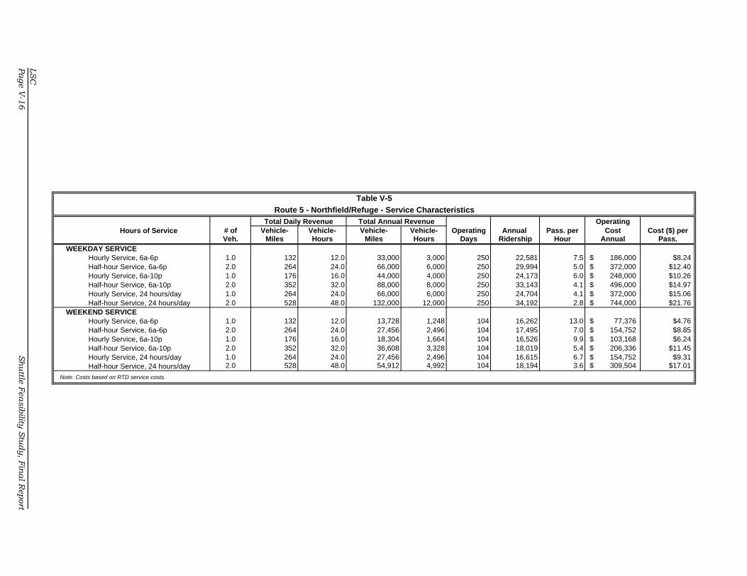
Table V-5
Route 5 - Northfield/Refuge - Service Characteristics
OperatingHours of Service # of Vehicle- Vehicle- Vehicle- Vehicle- Operating Annual Pass. per Cost Cost ($) per
Veh. Miles Hours Miles Hours Days Ridership Hour Annual Pass.WEEKDAY SERVICE
Hourly Service, 6a-6p 1.0 132 12.0 33,000 3,000 250 22,581 7.5 186,000$ $8.24Half-hour Service, 6a-6p 2.0 264 24.0 66,000 6,000 250 29,994 5.0 372,000$ $12.40Hourly Service, 6a-10p 1.0 176 16.0 44,000 4,000 250 24,173 6.0 248,000$ $10.26Half-hour Service, 6a-10p 2.0 352 32.0 88,000 8,000 250 33,143 4.1 496,000$ $14.97Hourly Service, 24 hours/day 1.0 264 24.0 66,000 6,000 250 24,704 4.1 372,000$ $15.06Half-hour Service, 24 hours/day 2.0 528 48.0 132,000 12,000 250 34,192 2.8 744,000$ $21.76
WEEKEND SERVICEHourly Service, 6a-6p 1.0 132 12.0 13,728 1,248 104 16,262 13.0 77,376$ $4.76Half-hour Service, 6a-6p 2.0 264 24.0 27,456 2,496 104 17,495 7.0 154,752$ $8.85Hourly Service, 6a-10p 1.0 176 16.0 18,304 1,664 104 16,526 9.9 103,168$ $6.24Half-hour Service, 6a-10p 2.0 352 32.0 36,608 3,328 104 18,019 5.4 206,336$ $11.45Hourly Service, 24 hours/day 1.0 264 24.0 27,456 2,496 104 16,615 6.7 154,752$ $9.31Half-hour Service, 24 hours/day 2.0 528 48.0 54,912 4,992 104 18,194 3.6 309,504$ $17.01
Note: Costs based on RTD service costs.
Total Daily Revenue Total Annual Revenue
LS
C
Pa
ge V
-16
Sh
uttle
Fea
sib
ility S
tud
y, F
ina
l Rep
ort

Service Options
LSC
Shuttle Feasibility Study, Final Report Page V-17
Service Option 6: Events Route
This option was developed to provide service from the hotels along Tower Road.
This service would only operate on weekends or for weekday events at the sta-
dium. Figure V-6 presents the route alignment, while Table V-6 presents the
weekend/event operating characteristics.
Priority I Destinations Served
The Priority I destinations served by Route 6 include:
• Commerce City Civic Center
• Dicks’s Sporting Goods Park
Priority II Destinations Served
There are no Priority II destinations served by Route 6.
Priority III Destinations Served
The Priority III destination served by Route 6 includes:
• Tower Road Hotels
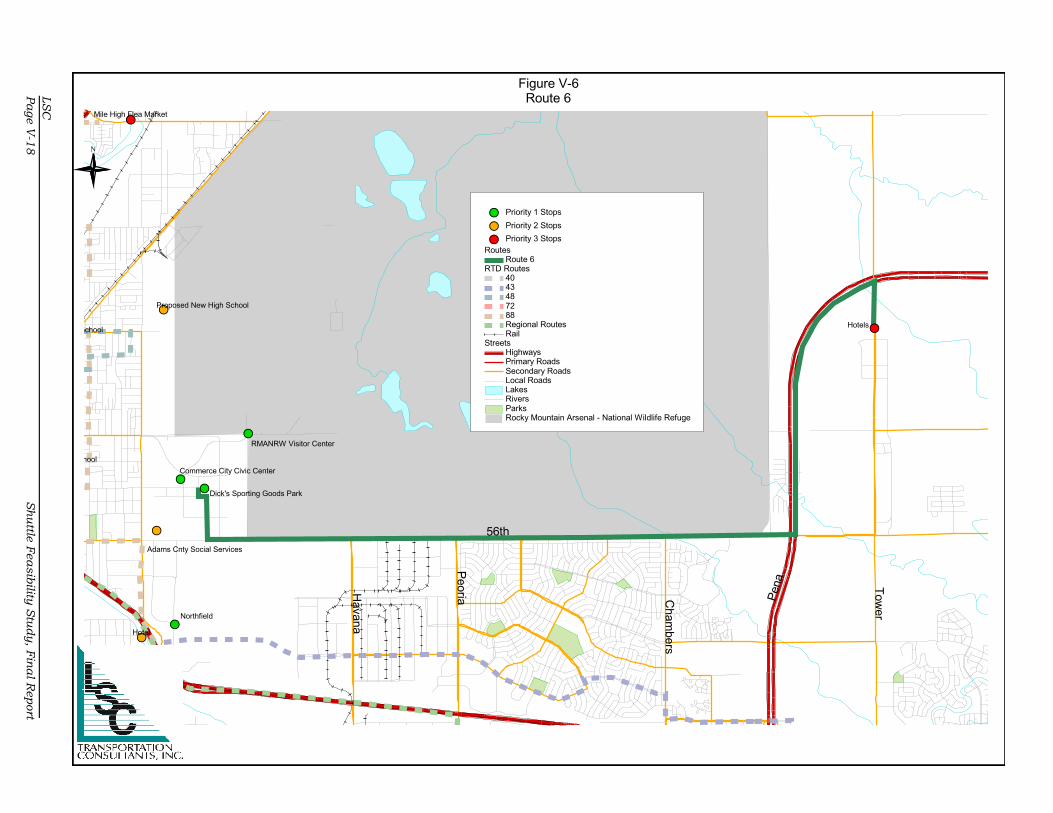
��
��
��
��
��
��
��
�� ��
��
������
������ �����
���
����
���������
��������� ����������
� ����������������������
����� � !�����"�#��� �����
�����
�����
����
���!� �����$���"� ����
�����
����
�������"�%����������
'�$��
���� ����� ������ ������
%�"&����(���&����
��������&�������� �����(����������������������&"����� ����� )���
����� ��"$�� ������������ ������������� )���������
����
�'����&�� *+*,*-./--��"��������&��
��&�� ��&����
�� ���������,� ��! �� ���������/� ��! �� ���������0� ��!
�
LS
C
Pa
ge V
-18
Sh
uttle
Fea
sib
ility S
tud
y, F
ina
l Rep
ort

Table V-6
Route 6 - Event/Hotels - Service Characteristics
OperatingHours of Service # of Vehicle- Vehicle- Vehicle- Vehicle- Operating Annual Pass. per Cost Cost ($) per
Veh. Miles Hours Miles Hours Days Ridership Hour Annual Pass.WEEKEND SERVICE
Hourly Service, 6a-6p 2.0 240 24.0 24,960 2,496 104 15,853 6.4 154,752$ $9.76Half-hour Service, 6a-6p 4.0 480 48.0 49,920 4,992 104 16,705 3.3 309,504$ $18.53Hourly Service, 6a-10p 2.0 320 32.0 33,280 3,328 104 16,032 4.8 206,336$ $12.87Half-hour Service, 6a-10p 4.0 640 64.0 66,560 6,656 104 17,063 2.6 412,672$ $24.19Hourly Service, 24 hours/day 2.0 480 48.0 49,920 4,992 104 16,092 3.2 309,504$ $19.23Half-hour Service, 24 hours/day 4.0 960 96.0 99,840 9,984 104 17,182 1.7 619,008$ $36.03
Note: Costs based on RTD service costs.
Total Daily Revenue Total Annual Revenue
LS
C
Sh
uttle
Fea
sib
ility S
tud
y, F
ina
l Report
Pa
ge V
-19

Service Options
LSC
Page V-20 Shuttle Feasibility Study, Final Report
Service Option 7: Commerce City Shuttle
This option was created to provide service to all Priority I destinations. Figure V-7
illustrates the route alignment of this option, while Table V-7 presents operating
characteristics.
Priority I Destinations Served
The Priority I destinations served by Route 7 include:
• Rocky Mountain Arsenal Wildlife Refuge Visitors Center
• Commerce City Civic Center
• Dick’s Sporting Goods Park
• Wal-Mart
• Commerce City Recreation Center
• Northfield Mall
• Stapleton Transfer Station
Priority II Destinations Served
The Priority II destination served by Route 7 includes:
• Hotels on Quebec
Priority III Destinations Served
There are no Priority III destinations served.
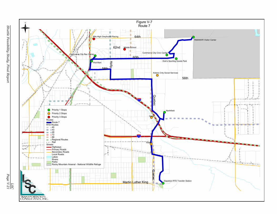
��
��
��
��
��
��
����
��
����
��
����
����
�����
���
�����
�� ��������� �����
�����
����� �
���
�����
����
����
������ �
�� �������
�� ����!�"��� �#����
#�$$� ��#�������#����
%��&�������'(�' ��"�� �%������
#�$$� ��#����#�)��#����
(�*+"�%&� �����,���"�-� *
�����
�����
�������%����
����������, �������������
��$"�#����%�����%� )��"
.��� ��!�/������/
��*����������� "�������������������������������-� *"��)� "��*�"
%� ���"����0��"- �$� ������"%����� ������"���������"
����
�'(������"��1��/�����������������"
�����"������/
�� - �� ����1�%��&"�� - �� ������%��&"�� - �� ����2�%��&"
�
LS
C
Sh
uttle
Fea
sib
ility S
tud
y, F
ina
l Report
Pa
ge V
-21

Table V-7
Route 7 - Northfield/Stapleton/Refuge - Service Characteristics
OperatingHours of Service # of Vehicle- Vehicle- Vehicle- Vehicle- Operating Annual Pass. per Cost Cost ($) per
Veh. Miles Hours Miles Hours Days Ridership Hour Annual Pass.WEEKDAY SERVICE
Hourly Service, 6a-6p 1.0 120 12.0 30,000 3,000 250 30,291 10.1 186,000$ $6.14Half-hour Service, 6a-6p 2.0 240 24.0 60,000 6,000 250 44,941 7.5 372,000$ $8.28Hourly Service, 6a-10p 1.0 160 16.0 40,000 4,000 250 33,502 8.4 248,000$ $7.40Half-hour Service, 6a-10p 2.0 320 32.0 80,000 8,000 250 51,228 6.4 496,000$ $9.68Hourly Service, 24 hours/day 1.0 240 24.0 60,000 6,000 250 34,572 5.8 372,000$ $10.76Half-hour Service, 24 hours/day 2.0 480 48.0 120,000 12,000 250 53,324 4.4 744,000$ $13.95
WEEKEND SERVICEHourly Service, 6a-6p 1.0 120 12.0 12,480 1,248 104 17,544 14.1 77,376$ $4.41Half-hour Service, 6a-6p 2.0 240 24.0 24,960 2,496 104 19,982 8.0 154,752$ $7.74Hourly Service, 6a-10p 1.0 160 16.0 16,640 1,664 104 18,079 10.9 103,168$ $5.71Half-hour Service, 6a-10p 2.0 320 32.0 33,280 3,328 104 21,028 6.3 206,336$ $9.81Hourly Service, 24 hours/day 1.0 240 24.0 24,960 2,496 104 18,257 7.3 154,752$ $8.48Half-hour Service, 24 hours/day 2.0 480 48.0 49,920 4,992 104 21,377 4.3 309,504$ $14.48
Note: Costs based on RTD service costs.
Total Daily Revenue Total Annual Revenue
LS
C
Pa
ge V
-22
Sh
uttle
Fea
sib
ility S
tud
y, F
ina
l Rep
ort

Service Options
LSC
Shuttle Feasibility Study, Final Report Page V-23
RTD-DENVER ROUTE 88 REALIGNMENT OPTIONS
A possible alternative to developing new transit service would be realignment of
current RTD service in the study area. Although realignment would not serve all
the destinations developed by the Stakeholders Group, possible realignment of
RTD Route 88 from Monaco to Quebec could provide service to Lester Arthur High
School, the new high school in the Gateway development, the Commerce City Civic
Center, the RMANWR Visitors Center, and Dick’s Sporting Goods Park. Route 88
currently serves the Mile High Flea Market, the Wal-Mart Super Center on Dahlia,
the Commerce City Recreational Center, hotels along Quebec, and the Stapleton
Transfer Center. The realignment of this route would cover all the destinations
listed as Priority I and several destinations listed as Priorities II and III. RTD Route
88 provides daily service every 30 minutes from 4:44 a.m. to 11:45 p.m. Figure
V-8 shows the existing RTD Route 88 with the proposed realignment shown in
dashed lines.
RMANWR TRAM SERVICE
During the years when the arsenal produced chemical weapons, a tramway
service was developed to transport employees to and from the various manufac-
turing sites located at the arsenal. When the arsenal site was transferred to the
Fish and Wildlife Service, plans were made to use the tram to transport visitors
through the new wildlife refuge on guided tours. A possible option for the tram
service would be to extend it to the Commerce City Civic Center. This would
provide access to the wildlife refuge for people visiting the Civic Center and Dick’s
Sporting Goods Stadium and Soccer Complex. It may also provide ease of access
and movement for transit buses and charter buses. These buses would not need
to maneuver through the Visitor Center parking lot. Instead, they could use 60th
to the Commerce City Civic Center, drop off passengers, then either park at the
stadium (when it is not in use) or at an ancillary parking lot for buses and
recreational vehicles near the Visitor Center.
BIKE AND PEDESTRIAN CONNECTIONS
Several of the options include connections to trailheads on 96th Street, as well as
providing pedestrian connections to the Refuge at the Visitors Center. Connections

Service Options
LSC
Page V-24 Shuttle Feasibility Study, Final Report
to the hiking/biking trails represents an opportunity for transit services to expand
their service areas and provide linkages to recreational trails in the area. One
element that should be included in all future service options is to provide bicycle
racks on vehicles. This rather inexpensive opportunity allows bicycle riders to use
transit for greater access. Typically, pedestrians will walk no more than one-
quarter mile to reach a bus stop, while a cyclist is much more willing to bike
several miles to reach a bus. The opportunity to connect transit to trails and
provide bicycle opportunities makes transit more user-friendly. However, access
to hiking may be less important in terms of service options and may be something
to add in future phases as feasibility warrants such service.

��
��
��
��
��
����
����
��
��
��
��
�� ��
��
����
��
������
�������� �����
������
�����
���
���
���
���
��� ���
�����
����� �
�����
������
�������� ���
�������� ���
������ ������������
������ ����� ��������
�����
�����
��!"�#����� ��� ���
��"���� ������� ��� ���
$�%���������� ��� ���
#�!!�����#���&� ��!"�#������������'��"
(��)����
$��� *���
��$(��+"����#����
#�!!�����#�������#����
���,������-.�-��"*��������
#�!!�����#���#'��#����
.��/"��,���������"������!
#����"����$��� ���
������+)��-.���������������
������������ �"����)�$������(���*����*���&���"�'��"����"
������"�� %��"&�!��������"�������������"����������"
���
�-.������01"�������������������������!��
�� &������2����,"�� &�����������,"�� &������3����,"
�
LS
C
Sh
uttle
Fea
sib
ility S
tud
y, F
ina
l Report
Pa
ge V
-25

Service Options
LSC
Page V-26 Shuttle Feasibility Study, Final Report
PRIORITY DESTINATIONS SERVED
It was not practical to develop routes that would exclusively serve each priority
destination established by the Stakeholder Group due to the extreme distances
between the established service destinations. Therefore, LSC developed practical
routes that can be established and possibly used in a transit network of routes.
LSC staff was able to develop a route that would serve all of the Priority II desti-
nations (Route 7). Table V-8 summarizes the destinations by priority served by
each service option. The route serving the most destinations is Route 4 which
serves 12 destinations. All of the Priority I destinations are served on this route
except for the Stapleton Transfer Station. Route 3 serves 11 destinations, but does
not provide service to Northfield Mall or the Stapleton Transfer Station. The RTD
Route 88 realignment serves 10 destinations and all destinations except Northfield
Mall on the Priority I list. However, individuals interested in going to Northfield
Mall could transfer onto the RTD Route 43 bus.

Points Route 1 Route 2 Route 3 Route 4 Route 5 Route 6 Route 7 RTD Rt 88PRIORITY I DESTINATIONSRMANWR Visitors Center ■ ■ ■ ■ ■ ■ ■Commerce City Civic Center ■ ■ ■ ■ ■ ■ ■Dick's Sporting Goods Park ■ ■ ■ ■ ■ ■ ■Wal-Mart on Dahlia ■ ■ ■ ■ ■Commerce City Recreation Center ■ ■ ■ ■ ■Northfield ■ ■Stapleton Transfer Station ■ ■ ■PRIORITY II DESTINATIONSAdams County Social Services ■Lester Arnold High School ■ ■ ■Adams County High School ■Proposed New High School ■ ■ ■ ■Trailhead at 96th and Peoria ■Trailhead at 96th and Chambers ■Commerce City Park-and-Ride ■Planned Commuter Rail StationHotels along Quebec Boulevard ■ ■ ■PRIORITY III DESTINATIONSCU Medical Complex ■Commerce City Middle Schools ■ ■Mile High Greyhound Racing Track ■Bell Creek Recreation Center ■Reunion Recreational Center ■Mile High Flea Market ■ ■Hotels along Tower Boulevard ■ ■
TOTALS 4 7 11 12 5 4 8 10
Points Served By RouteTable V-8
LS
C
Sh
uttle
Fea
sib
ility S
tud
y, F
ina
l Report
Pa
ge V
-27

Service Options
LSC
Page V-28 Shuttle Feasibility Study, Final Report
RIDERSHIP ESTIMATION METHODOLOGY
In order to determine more precise ridership demand estimates, a fixed-route
model was used as a means of evaluation. Although demand has already been
estimated previously, the fixed-route model allows demand to be shown for each
individual route alternative.
The fixed-route model uses numerous factors, attributed by census block, that aid
in the estimate of ridership. The presence of zero- and one-vehicle households
within one-quarter of a mile of the proposed route alternative are key demographic
factors. These values are then combined with service options—such as headways
(frequency) and average walking distances—to give an estimated demand by route.
This technique was applied to each of the route alternatives and under multiple
scenarios.
Since the model is calibrated to predict demand for a typical 12-hour service day,
some modifications were made to extrapolate the data to 16- and 24-hour service.
RTD data were examined to determine the decrease in ridership outside of the
peak service times. It was determined that a 16-hour service day represents the
12-hour service day ridership plus an additional 21 percent, while the 24-hour
service day represents the 12-hour service day plus an additional 28 percent
ridership increase.
This model also accounts for the demand that is created for the purpose of
recreation. Thus, the route alternatives that serve the regional recreation areas—
such as Dick’s Sporting Goods Park and the Refuge—have the forecasted recrea-
tion demand of 15,000 trips annually allocated to the ridership estimates. This
number is expected to be distributed more prominently on the weekend when a
greater proportion of ridership is generally attributed to recreational activities as
opposed to work trips.
Table V-9 provides a summary of ridership estimates for each route and service
option.
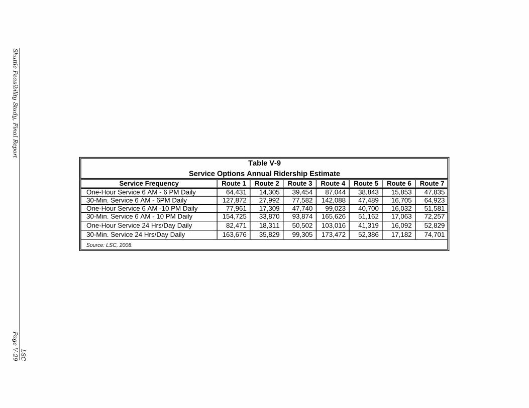
Table V-9
Service Options Annual Ridership EstimateService Frequency Route 1 Route 2 Route 3 Route 4 Route 5 Route 6 Route 7
One-Hour Service 6 AM - 6 PM Daily 64,431 14,305 39,454 87,044 38,843 15,853 47,835 30-Min. Service 6 AM - 6PM Daily 127,872 27,992 77,582 142,088 47,489 16,705 64,923 One-Hour Service 6 AM -10 PM Daily 77,961 17,309 47,740 99,023 40,700 16,032 51,581 30-Min. Service 6 AM - 10 PM Daily 154,725 33,870 93,874 165,626 51,162 17,063 72,257 One-Hour Service 24 Hrs/Day Daily 82,471 18,311 50,502 103,016 41,319 16,092 52,829 30-Min. Service 24 Hrs/Day Daily 163,676 35,829 99,305 173,472 52,386 17,182 74,701
Source: LSC, 2008.
LS
C
Sh
uttle
Fea
sib
ility S
tud
y, F
ina
l Report
Pa
ge V
-29

Chapter VI

LSC
Shuttle Feasibility Study, Final Report Page VI-1
CHAPTER VI
Shuttle Impacts to Area
INTRODUCTION
This chapter presents an overview of the economic and environmental benefits
that transit offers to the area. The first part of this section reviews the overall
background and economic benefits of transit using an economic multiplier model.
The second part of this section presents the estimated economic benefits for each
transit option presented in Chapter V. Finally, this chapter discusses the environ-
mental benefits of transit and potential to increase visitors to the area.
ECONOMIC BENEFITS OF TRANSIT
Economic and financial benefits and disbenefits are important factors in transit
benefit analysis. A financial viewpoint includes benefits that can be recovered as
income or that contribute to the rate of return for transit investment. An economic
viewpoint assumes benefits can be measured or converted to a monetary unit.
This means the creation of jobs and the increase in personal income, business
activity (sales), and tax revenue for the community. As expenditures for transit
increase, the effect on the local economy (in terms of business sales, employment,
and income) can be measured and contributed to the improvement of transit.
Net Economic Benefit
The total result of this analysis is the net economic benefit of the transit oper-
ations and capital purchases in the region. In order to obtain the net impact, the
gross benefits of operations, facilities construction, and durable goods are added
together by each of the five multiplier categories—total sales, employment, wages
and salaries, proprietors’ income, and property income. The total of these benefits
is then subtracted by the damping impacts of the same five multiplier categories.
The benefit of tax revenue and the efficiency effect are added to the gross benefit
total.
Shuttle Impacts to Area
LSC
Page VI-2 Shuttle Feasibility Study, Final Report
The formula is as follows:
Net Transit Benefit =
Gross Benefits - Damping Impact + Tax Benefit + Efficiency Effect
IMPLAN Model for Public Transit
The IMPLAN model used to analyze public transportation spending effects relies
on economic impact multipliers generated through the IMPLAN regional input/
output modeling system. IMPLAN was originally developed in the early 1980s by
the US Forest Service for use in their land management impact planning and
analysis. IMPLAN has since become a commercially available product (Minnesota
IMPLAN Group in Stillwater, Minnesota) and is likely the most widely used tool for
conducting the type of regional impact analysis presented in this study. Details
on IMPLAN, including a list of users and examples of IMPLAN applications, can be
found on the website http://implan.com.
Input/Output Multipliers
Input/output multipliers distinguish economic effects according to three cate-
gories—direct, indirect, and induced. Direct effects are those in the immediate
industry (e.g., jobs and incomes in public transit itself). Indirect effects are those
in supporting industries (e.g., jobs and incomes in industries that supply inputs
to public transit). Induced effects result from the household spending stimulated
by the direct and indirect effects.
Multipliers are based on the interconnection of the regional economy whereby
dollars spent on inputs by one firm are received as revenues by other firms and
then spent on inputs and received by still other firms, and so on. A change in the
sales of one firm—the initial (direct) effect—sets in motion a sequence of other
effects—the indirect and induced. The analogy of tossing a stone into a pond is
often made. The first ripple is the initial (direct) effect; succeeding ripples are the
multiples of that effect. The total effect—indicated by the input/output multi-
plier— is the sum of the direct, indirect, and induced effects.
The IMPLAN model for the region was prepared as part of the Colorado Transit
Needs and Benefits Study and used multipliers for IMPLAN Sector #434 “Local

Shuttle Impacts to Area
1 For additional detail on IMPLAN multiplier definitions see Minnesota IMPLAN Group, Inc. 1996. IMPLAN Pro: User’s Guide, Analysis Guide, Data Guide. Minnesota IMPLAN Group, Inc.: Stillwater, Minnesota.
LSC
Shuttle Feasibility Study, Final Report Page VI-3
Inter-urban Passenger Transportation” to assess the impact of public transit.
Several Sector #434 input/output multipliers are used to estimate the role of
public transit for each regional economy. All multipliers are so-called IMPLAN
“Type II.”1
Economic Benefit Scenarios
Using the model from the above section, LSC estimated the increased economic
benefit of transit on the local economy based on the development and imple-
mentation of the seven route options presented in Chapter V. Tables VI-1 through
VI-7 present the economic benefits for the route options based on the conceptual
level of service for each route. The tables present the total economic benefits in
dollars, the net employment generated for the new transit service, and show the
estimated annual return on investment per dollar invested in transit. Note that the
economic benefits shown in these tables are not cumulative. Once a preferred
transit service plan is selected, an additional economic model can be developed
to determine the economic benefit of implementing that service. As shown in the
tables, the greater the level of service, the greater the total economic benefit gen-
erated from the new transit service.

Shuttle Impacts to Area
LSC
Page VI-4 Shuttle Feasibility Study, Final Report
Table VI-1
Econ omic Bene fits of Route 1
Total Ben efit New JobsReturn on
Investment
WEEKDAY SERVICE
Hourly Service, 6a-6p $2,147,196 277 $3.20
Half-hour Service, 6a-6p $4,212,947 288 $3.13
Hourly Service, 6a-10p $2,728,424 280 $3.43
Half-hour Service, 6a-10p $5,376,194 295 $3.38
Hourly Service, 24 hours/day $2,492,263 287 $3.81
Half-hour Service, 24 hours/day $7,873,076 309 $3.77
WEEKEND SERVICE
Hourly Service, 6a-6p $1,243,116 271 $2.73
Half-hour Service, 6a-6p $2,401,646 277 $2.64
Hourly Service, 6a-10p $1,497,765 272 $2.96
Half-hour Service, 6a-10p $2,911,074 280 $2.87
Hourly Service, 24 hours/day $2,021,347 275 $3.32
Half-hour Service, 24 hours/day $3,958,283 286 $3.25
Source: IMPLAN model and LSC, 2008.
Table VI-2
Econ omic Bene fits of Route 2
Total Ben efit New JobsReturn on
Investment
WEEKDAY SERVICE
Hourly Service, 6a-6p $2,338,033 277 $3.48
Half-hour Service, 6a-6p $4,593,208 289 $3.42
Hourly Service, 6a-10p $2,959,336 281 $3.72
Half-hour Service, 6a-10p $5,836,308 296 $3.67
Hourly Service, 24 hours/day $2,689,507 288 $4.04
Half-hour Service, 24 hours/day $8,359,809 311 $4.00
WEEKEND SERVICE
Hourly Service, 6a-6p $1,274,872 271 $2.80
Half-hour Service, 6a-6p $2,464,922 277 $2.71
Hourly Service, 6a-10p $1,536,188 273 $3.03
Half-hour Service, 6a-10p $2,987,637 280 $2.95
Hourly Service, 24 hours/day $2,061,994 276 $3.38
Half-hour Service, 24 hours/day $4,039,276 286 $3.31
Source: IMPLAN model and LSC, 2008.

Shuttle Impacts to Area
LSC
Shuttle Feasibility Study, Final Report Page VI-5
Table VI-3
Econ omic Bene fits of Route 3
Total Ben efit New JobsReturn on
Investment
WEEKDAY SERVICE
Hourly Service, 6a-6p $2,242,286 277 $3.34 Half-hour Service, 6a-6p $4,404,410 289 $3.28
Hourly Service, 6a-10p $2,843,482 280 $3.57
Half-hour Service, 6a-10p $5,607,863 296 $3.52
Hourly Service, 24 hours/day $2,591,576 288 $3.93
Half-hour Service, 24 hours/day $8,118,148 310 $3.89
WEEKEND SERVICE
Hourly Service, 6a-6p $1,258,939 271 $2.77
Half-hour Service, 6a-6p $2,433,506 277 $2.68
Hourly Service, 6a-10p $1,516,910 272 $3.00
Half-hour Service, 6a-10p $2,949,624 280 $2.91
Hourly Service, 24 hours/day $2,041,601 275 $3.35
Half-hour Service, 24 hours/day $3,999,063 286 $3.28
Source: IMPLAN model and LSC, 2008.
Table VI-4
Econ omic Bene fits of Route 4
Total Ben efit New JobsReturn on
Investment
WEEKDAY SERVICE
Hourly Service, 6a-6p $2,108,709 276 $3.14 Half-hour Service, 6a-6p $4,206,430 288 $3.13
Hourly Service, 6a-10p $2,695,842 280 $3.39
Half-hour Service, 6a-10p $5,382,296 295 $3.38
Hourly Service, 24 hours/day $2,488,882 287 $3.78
Half-hour Service, 24 hours/day $7,883,385 309 $3.78
WEEKEND SERVICE
Hourly Service, 6a-6p $1,181,186 271 $2.60
Half-hour Service, 6a-6p $2,345,036 276 $2.58
Hourly Service, 6a-10p $1,436,817 272 $2.84
Half-hour Service, 6a-10p $2,856,564 279 $2.82
Hourly Service, 24 hours/day $1,960,727 275 $3.22
Half-hour Service, 24 hours/day $3,904,473 285 $3.20
Source: IMPLAN model and LSC, 2008.

Shuttle Impacts to Area
LSC
Page VI-6 Shuttle Feasibility Study, Final Report
Table VI-5
Econ omic Bene fits of Route 5
Total Ben efit New JobsReturn on
Investment
WEEKDAY SERVICE
Hourly Service, 6a-6p $1,138,578 271 $3.39
Half-hour Service, 6a-6p $2,259,301 277 $3.36
Hourly Service, 6a-10p $1,447,878 273 $3.64
Half-hour Service, 6a-10p $2,878,059 281 $3.62
Hourly Service, 24 hours/day $1,326,162 276 $3.98
Half-hour Service, 24 hours/day $4,138,878 288 $3.96
WEEKEND SERVICE
Hourly Service, 6a-6p $612,362 268 $2.69
Half-hour Service, 6a-6p $1,206,245 271 $2.65
Hourly Service, 6a-10p $742,795 269 $2.93
Half-hour Service, 6a-10p $1,467,138 272 $2.90
Hourly Service, 24 hours/day $1,005,623 270 $3.30
Half-hour Service, 24 hours/day $1,992,802 275 $3.27
Source: IMPLAN model and LSC, 2008.
Table VI-6
Econ omic Bene fits of Route 6
Total Ben efit New JobsReturn on
Investment
WEEKDAY SERVICE
Hourly Service, 6a-6p $1,213,536 271 $2.67
Half-hour Service, 6a-6p $2,408,474 277 $2.65
Hourly Service, 6a-10p $1,475,961 272 $2.91
Half-hour Service, 6a-10p $2,933,324 280 $2.90
Hourly Service, 24 hours/day $1,409,640 275 $3.28
Half-hour Service, 24 hours/day $3,985,673 286 $3.27
Source: IMPLAN model and LSC, 2008.

Shuttle Impacts to Area
LSC
Shuttle Feasibility Study, Final Report Page VI-7
Table VI-7
Econ omic s Ben efits of Route 7
Total Ben efit New JobsReturn on
Investment
WEEKDAY SERVICE
Hourly Service, 6a-6p $1,104,343 271 $3.29
Half-hour Service, 6a-6p $2,192,928 277 $3.26
Hourly Service, 6a-10p $1,406,454 273 $3.53
Half-hour Service, 6a-10p $2,797,747 280 $3.51
Hourly Service, 24 hours/day $1,291,733 276 $3.90
Half-hour Service, 24 hours/day $4,053,920 287 $3.88
WEEKEND SERVICE
Hourly Service, 6a-6p $606,665 268 $2.67
Half-hour Service, 6a-6p $1,195,200 271 $2.63
Hourly Service, 6a-10p $735,902 269 $2.91
Half-hour Service, 6a-10p $1,453,774 272 $2.87
Hourly Service, 24 hours/day $998,331 270 $3.28
Half-hour Service, 24 hours/day $1,978,665 275 $3.25
Source: IMPLAN model and LSC, 2008.
ENVIRONMENTAL BENEFITS OF TRANSIT
Providing transit access for Commerce City and Stapleton residents to the Rocky
Mountain Arsenal National Wildlife Refuge (RMANWR) has several environmental
benefits. This section details some of the environmental benefits of providing
transit.
The Clean Air Act of 1970 began focusing on air quality standards around the
country. Since that time, measurement of the impacts of transit projects and plans
on energy consumption has become a routine element in the evaluation of pro-
posed transit improvements. Unfortunately, the true environmental quality ben-
efits—air quality and reduced traffic congestion of a transit alternative—cannot be
easily quantified and expressed in dollar terms. To do so, the analysis must
include health benefits, reductions in the loss of life, impacts on the natural
environment and aesthetics, and many more factors.
Improves Air Quality
Though a bus may produce more exhaust than a car, it will also transport more
people, hence it reduces air pollution and improves air quality. Many metropolitan

Shuttle Impacts to Area
LSC
Page VI-8 Shuttle Feasibility Study, Final Report
areas are using the reduction of emissions to develop standards for their par-
ticular area. Reductions in overall travel will lead to lower air pollutant emissions,
reduced noise levels, and other effects.
Reduces the Land for Development
Transit reduces the demand for parking, which in turn reduces the money in-
vested to build or maintain these parking spaces/lots. By reducing the amount of
surface parking, transit can decrease the need to consume more land for develop-
ment, thereby reducing the stress on local waterways in terms of storm runoffs.
Reduces Congestion and Prevents Widening Highways
Transit reduces congestion on streets. Based on the number of passengers that
ride transit, the number of cars on the street will be reduced and the widening of
highways to support the increased number of cars will be prevented. The depen-
dence on fossil fuel consumption will also be reduced.
INCREASE IN VISITATION
It is difficult to quantify the actual increase that the area could see in visitation
due to the implementation of transit. It is likely that the increased accessibility of
the area, due to transit service, could produce an increase in visitation from those
who either do not have the ability or option to drive to the area for recreation or
from those who choose not to drive. Currently, RTD services experience a small
percentage of ridership for social/recreational purposes. However, the connection
between RTD and a shuttle service to recreational events could increase the
proportion on the RTD routes serving the area. Much of the ridership on the
routes is attributed to the park-and-ride lots in the area. Any new services which
link the RTD and shuttle services are likely to increase visitation to the area. The
demand for services which are recreation specific appears to be mostly concen-
trated during the weekends when people would use the Refuge and/or attend an
event at the stadium.

Chapter VII

LSCShuttle Feasibility Study, Final Report Page VII-1
CHAPTER VII
Preferred Service Plan
INTRODUCTION
Based upon the analysis of the various alternatives presented in previous chapters,
public comment, and the Stakeholder Group input, the LSC Team prepared the
Preferred Service Plan. At the request of the Stakeholders Group, LSC has also
developed five options to the Service Plan that can be provided at a lower cost than
the preferred service. These options were developed to allow for the economic
downturn facing the study area and the nation at this time.
SERVICE PLAN
A Preferred Service Plan has been developed based upon refinement of the Transit
Service Options presented in Chapter V. The Preferred Plan is the Route 5 alter-
native presented in the Service Options with street changes recommended by the
Stakeholders Group. LSC also recommends that this service operate on a 30-
minute frequency of service from 6:00 a.m. to 10:00 p.m. seven days a week.
Operating from 6:00 a.m. to 10:00 p.m. allows for coverage of a variety of work
schedules and evening events. For instance, individuals using the route to go to
work at the Commerce City Civic Center and working on the traditional 8:00 a.m.
to 5:00 p.m. schedule can use the bus if they have to work late. Operating seven
days a week offers people the ability to work weekend retail jobs. The Stakeholders
Group also suggested the possible use of Service Option 7. The primary difference
between these two options is that Service Option 7 provides service along 56th,
Holly, 58th, and 60th Streets as well as serving two additional Priority 1 stops (Wal-
Mart and the Commerce City Recreation Center). At first glance, Option 7 seems
more desirable than Option 5 since it serves a greater area of the community;
however, this area is currently being served by RTD Route 88.
The Stakeholders Group was also interested in the possible realignment of RTD
Route 88 to provide transit service to the Commerce City Civic Center, Dick’s

Preferred Service Plan
LSCPage VII-2 Shuttle Feasibility Study, Final Report
Sporting Goods Park, and the Rocky Mountain Arsenal National Wildlife Refuge.
LSC discussed this realignment possibility with RTD staff. RTD stated that Com-
merce City can request this realignment by sending a formal request letter to RTD.
RTD will then investigate to see if this route realignment meets its required design
and performance standards for suburban bus routes. Currently, Route 88 meets
or exceeds all RTD performance standards for local suburban bus service. This
may make RTD hesitant to change the service. Table VII-1 shows the average
performance standard for local suburban service compared to the performance of
Route 88. Figure VII-1 shows the recommended new route alignment.
Table VII-1
RTD Performance Standards for Suburban Local Service
Performance StandardSuburban Local Service
Standard AverageRoute 88 Performance
Standard
Farebox Revenue $81,433 $238,210
Operating Cost $842,900 $1,643,239
Total Annual Boardings 102,000 286,534
In-Service Hours 6,515 15,149
Net Subsidy $761,400 $1,405,028
Subsidy per Boarding $8 $5
Boardings per Hour 16 19
* Source RTD-Denver 2006 Performance Standard Analysis.

��
��
����
��
������
��
����
��
����
��
����
��
����
������
���
����
� ��
����������������
���� ��
�����
��������
���������
�������������������
�� ������!��������
"��#������$%�$�������"������
�� ������!���&�������
%��'(��"#�������)�����*��'
+���+���
������"�����
����+����)�!�����������
��� �����!�"������"�&���
+���
+���
+���
+���
+���
+���
,�����--�.*������"�&������
���'!��������������������������������������*��'���&����'�
"����+���/�!�*�� ��!������"������!�����������������
����
�$%������ �0�12311������������
���������
�� *������!�0�"��#��� *������!�3�"��#��� *������!�.�"��#�
�
LSC
Sh
uttle F
easib
ility S
tud
y, F
ina
l Rep
ortPage V
II-3

Preferred Service Plan
LSCPage VII-4 Shuttle Feasibility Study, Final Report
Service Plan Costs
The operational costs for providing the Preferred Service Plan are provided in Table
VII-2. Operation costs are based upon contracted rates provided to LSC from RTD.
Commerce City may also elect to contract this service to a private transit man-
agement firm or operate the service themselves. These alternatives are discussed
in more detail in Chapter IX.

Table VII-2
Preferred Route - Northfield/Stapleton/Refuge - Service Characteristics
OperatingHours of Service # of # of Vehicle- Vehicle- Vehicle- Vehicle- Operating Annual Pass. per Cost Cost ($) per
Veh. Round-Trips Miles Hours Miles Hours Days Ridership Hour Annual Pass.WEEKDAY SERVICE
Half-hour Service, 6a-10p 2.0 32 320 32.0 80,000 8,000 250 44,941 5.6 496,000$ $11.04WEEKEND SERVICE
Half-hour Service, 6a-10p 2.0 32 320 32.0 33,280 3,328 104 19,982 6.0 206,336$ $10.33
Note: Costs based on RTD service costs.
Total Daily Revenue Total Annual Revenue
LSC
Sh
uttle F
easib
ility S
tud
y, F
ina
l Rep
ortPage V
II-5

Preferred Service Plan
LSCPage VII-6 Shuttle Feasibility Study, Final Report
PREFERRED SERVICE PLAN OPTIONS
The Stakeholders Group has asked LSC to develop some alternatives to the Pre-
ferred Service Plan that would provide similar service but at a lower cost. This can
be accomplished in two ways—reducing the hours of service and reducing the
service area. Below are five alternatives that provide lower costs.
Alternative 1 - Hourly Service
The Preferred Service Plan recommends that the new transit service route should
be operated on a 30-minute headway. In this alternative, the 30-minute frequency
is changed to a one-hour headway. The savings incurred from going to hourly
service is that only one bus and driver are needed. With 30-minute service fre-
quency, two buses and drivers are needed. Table VII-3 depicts the cost difference
between the Preferred Service Plan and this alternative. As shown, Alternative 1
would provide a savings of $351,000 compared to the cost of the Preferred Service
Plan. However, the economic benefits derived from this alternative would be less
than in the Preferred Service Plan. This table also breaks down the cost of oper-
ating weekday service only or weekend service only for the purpose of having
another option.
Table VII-3
Alternative 1 - Hourly Service 6 a.m. - 10 p.m.
ServiceEstimated
CostEstimatedRidership
Total EconomicBenefit
New JobsCreated
Alternative 1
Weekday Service $248,000 24,173 $1,447,878 273
Weekend Service $103,168 16,526 $742,795 269
Alternative 1 Total $351,168 40,700 $2,190,673 541
Difference fromPreferred Service
-$351,168 -24,223 -$2,154,524 -12

Preferred Service Plan
LSCShuttle Feasibility Study, Final Report Page VII-7
Table VII-4 is a sample schedule for this alternative. As shown, the service operates
on an hourly frequency of service from 6:00 a.m. to 10:00 p.m. This schedule will
be for both weekday and weekend service.
Table VII-4
Sample Route Schedule – One-Hour Service Frequency
DepartTransfer
Point
NorthfieldMall
Dick'sSporting
Goods Park
Depart WildlifeRefuge Visitors
Center
Dick's SportingGoods Park
NorthfieldMall
ArriveTransfer
Point
6:00 AM 6:10 AM 6:18 AM 6:23 AM 6:31 AM 6:39 AM 6:49 AM 7:00 AM 7:10 AM 7:18 AM 7:23 AM 7:31 AM 7:39 AM 7:49 AM 8:00 AM 8:10 AM 8:18 AM 8:23 AM 8:31 AM 8:39 AM 8:49 AM 9:00 AM 9:10 AM 9:18 AM 9:23 AM 9:31 AM 9:39 AM 9:49 AM
10:00 AM 10:10 AM 10:18 AM 10:23 AM 10:31 AM 10:39 AM 10:49 AM 11:00 AM 11:10 AM 11:18 AM 11:23 AM 11:31 AM 11:39 AM 11:49 AM 12:00 PM 12:10 PM 12:18 PM 12:23 PM 12:31 PM 12:39 PM 12:49 PM 1:00 PM 1:10 PM 1:18 PM 1:23 PM 1:31 PM 1:39 PM 1:49 PM 2:00 PM 2:10 PM 2:18 PM 2:23 PM 2:31 PM 2:39 PM 2:49 PM 3:00 PM 3:10 PM 3:18 PM 3:23 PM 3:31 PM 3:39 PM 3:49 PM 4:00 PM 4:10 PM 4:18 PM 4:23 PM 4:31 PM 4:39 PM 4:49 PM 5:00 PM 5:10 PM 5:18 PM 5:23 PM 5:31 PM 5:39 PM 5:49 PM 6:00 PM 6:10 PM 6:18 PM 6:23 PM 6:31 PM 6:39 PM 6:49 PM 7:00 PM 7:10 PM 7:18 PM 7:23 PM 7:31 PM 7:39 PM 7:49 PM 8:00 PM 8:10 PM 8:18 PM 8:23 PM 8:31 PM 8:39 PM 8:49 PM 9:00 PM 9:10 PM 9:18 PM 9:23 PM 9:31 PM 9:39 PM 9:49 PM
Alternative 2 - Peak Period Service
This alternative incorporates a peak period service which provides 30-minute fre-
quency of service from 6:00 to 9:00 a.m. and from 3:00 to 6:00 p.m. During the
rest of the day the service operates on an hourly frequency of service. Weekend
service is proposed to operate on an hourly frequency of service all day. Peak
period transit service is designed to provide more transit service during the tradi-
tional commute to work times and then reduce the amount of service during non-
commute hours. Alternative 2 costs $260,000 less to operate than the Preferred
Service Plan. Table VII-5 details the costs savings and economic benefits of
Alternative 2 as compared to the Preferred Service Plan.

Preferred Service Plan
LSCPage VII-8 Shuttle Feasibility Study, Final Report
Table VII-5
Alternative 2 - Peak Service 6 a.m. - 10 p.m.
Service Estimated CostEstimatedRidership
Total EconomicBenefit
New JobsCreated
Alternative 2
Weekday Peak $186,000 9,450 $1,882,980 153
Weekday Off-Peak $155,000 15,000 $1,129,788 400
Weekend Service $103,168 16,526 $742,795 269
Alternative 2 Total $444,168 31,526 $1,872,583 669
Difference fromPreferred Service -$258,168 -33,397 -$2,472,614 116
Table VII-6 is a sample schedule for this alternative. As shown, the service operates
on a 30-minute frequency of service during peak commute times and hourly
frequency of service for the rest of the day. This schedule would be for weekday
service only. Hourly service as depicted in Alternative 1 would operate on week-
ends.
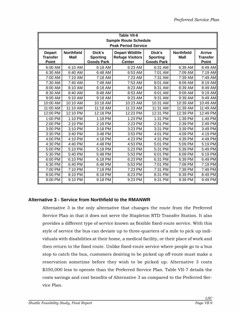
Preferred Service Plan
LSCShuttle Feasibility Study, Final Report Page VII-9
Table VII-6Sample Route Schedule
Peak Period Service
DepartTransfer
Point
NorthfieldMall
Dick'sSporting
Goods Park
Depart WildlifeRefuge Visitors
Center
Dick'sSporting
Goods Park
NorthfieldMall
ArriveTransfer
Point
6:00 AM 6:10 AM 6:18 AM 6:23 AM 6:31 AM 6:39 AM 6:49 AM 6:30 AM 6:40 AM 6:48 AM 6:53 AM 7:01 AM 7:09 AM 7:19 AM 7:00 AM 7:10 AM 7:18 AM 7:23 AM 7:31 AM 7:39 AM 7:49 AM 7:30 AM 7:40 AM 7:48 AM 7:53 AM 8:01 AM 8:09 AM 8:19 AM 8:00 AM 8:10 AM 8:18 AM 8:23 AM 8:31 AM 8:39 AM 8:49 AM 8:30 AM 8:40 AM 8:48 AM 8:53 AM 9:01 AM 9:09 AM 9:19 AM 9:00 AM 9:10 AM 9:18 AM 9:23 AM 9:31 AM 9:39 AM 9:49 AM
10:00 AM 10:10 AM 10:18 AM 10:23 AM 10:31 AM 10:39 AM 10:49 AM 11:00 AM 11:10 AM 11:18 AM 11:23 AM 11:31 AM 11:39 AM 11:49 AM 12:00 PM 12:10 PM 12:18 PM 12:23 PM 12:31 PM 12:39 PM 12:49 PM 1:00 PM 1:10 PM 1:18 PM 1:23 PM 1:31 PM 1:39 PM 1:49 PM 2:00 PM 2:10 PM 2:18 PM 2:23 PM 2:31 PM 2:39 PM 2:49 PM 3:00 PM 3:10 PM 3:18 PM 3:23 PM 3:31 PM 3:39 PM 3:49 PM 3:30 PM 3:40 PM 3:48 PM 3:53 PM 4:01 PM 4:09 PM 4:19 PM 4:00 PM 4:10 PM 4:18 PM 4:23 PM 4:31 PM 4:39 PM 4:49 PM 4:30 PM 4:40 PM 4:48 PM 4:53 PM 5:01 PM 5:09 PM 5:19 PM 5:00 PM 5:10 PM 5:18 PM 5:23 PM 5:31 PM 5:39 PM 5:49 PM 5:30 PM 5:40 PM 5:48 PM 5:53 PM 6:01 PM 6:09 PM 6:19 PM 6:00 PM 6:10 PM 6:18 PM 6:23 PM 6:31 PM 6:39 PM 6:49 PM 6:30 PM 6:40 PM 6:48 PM 6:53 PM 7:01 PM 7:09 PM 7:19 PM 7:00 PM 7:10 PM 7:18 PM 7:23 PM 7:31 PM 7:39 PM 7:49 PM 8:00 PM 8:10 PM 8:18 PM 8:23 PM 8:31 PM 8:39 PM 8:49 PM 9:00 PM 9:10 PM 9:18 PM 9:23 PM 9:31 PM 9:39 PM 9:49 PM
Alternative 3 - Service from Northfield to the RMANWR
Alternative 3 is the only alternative that changes the route from the Preferred
Service Plan in that it does not serve the Stapleton RTD Transfer Station. It also
provides a different type of service known as flexible fixed-route service. With this
style of service the bus can deviate up to three-quarters of a mile to pick up indi-
viduals with disabilities at their home, a medical facility, or their place of work and
then return to the fixed route. Unlike fixed-route service where people go to a bus
stop to catch the bus, customers desiring to be picked up off-route must make a
reservation sometime before they wish to be picked up. Alternative 3 costs
$350,000 less to operate than the Preferred Service Plan. Table VII-7 details the
costs savings and cost benefits of Alternative 3 as compared to the Preferred Ser-
vice Plan.
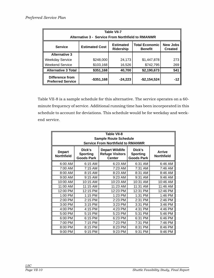
Preferred Service Plan
LSCPage VII-10 Shuttle Feasibility Study, Final Report
Table VII-7
Alternative 3 - Service From Northfield to RMANWR
Service Estimated CostEstimatedRidership
Total EconomicBenefit
New JobsCreated
Alternative 3
Weekday Service $248,000 24,173 $1,447,878 273
Weekend Service $103,168 16,526 $742,795 269
Alternative 3 Total $351,168 40,700 $2,190,673 541
Difference fromPreferred Service
-$351,168 -24,223 -$2,154,524 -12
Table VII-8 is a sample schedule for this alternative. The service operates on a 60-
minute frequency of service. Additional running time has been incorporated in this
schedule to account for deviations. This schedule would be for weekday and week-
end service.
Table VII-8Sample Route Schedule
Service From Northfield to RMANWR
DepartNorthfield
Dick'sSporting
Goods Park
Depart WildlifeRefuge Visitors
Center
Dick'sSporting
Goods Park
ArriveNorthfield
6:00 AM 6:15 AM 6:23 AM 6:31 AM 6:46 AM7:00 AM 7:15 AM 7:23 AM 7:31 AM 7:46 AM8:00 AM 8:15 AM 8:23 AM 8:31 AM 8:46 AM9:00 AM 9:15 AM 9:23 AM 9:31 AM 9:46 AM
10:00 AM 10:15 AM 10:23 AM 10:31 AM 10:46 AM11:00 AM 11:15 AM 11:23 AM 11:31 AM 11:46 AM12:00 PM 12:15 PM 12:23 PM 12:31 PM 12:46 PM1:00 PM 1:15 PM 1:23 PM 1:31 PM 1:46 PM2:00 PM 2:15 PM 2:23 PM 2:31 PM 2:46 PM3:00 PM 3:15 PM 3:23 PM 3:31 PM 3:46 PM4:00 PM 4:15 PM 4:23 PM 4:31 PM 4:46 PM5:00 PM 5:15 PM 5:23 PM 5:31 PM 5:46 PM6:00 PM 6:15 PM 6:23 PM 6:31 PM 6:46 PM7:00 PM 7:15 PM 7:23 PM 7:31 PM 7:46 PM8:00 PM 8:15 PM 8:23 PM 8:31 PM 8:46 PM9:00 PM 9:15 PM 9:23 PM 9:31 PM 9:46 PM

Preferred Service Plan
LSCShuttle Feasibility Study, Final Report Page VII-11
Alternative 4 - Event Service
This alternative has been developed to help guide the Stakeholder Group in devel-
oping charges for modifying service to transport people attending events at Dick’s
Sporting Goods Park. In order to comply with federal charter bus regulations, it is
recommended that Kroenke Enterprises (owner of the Park) be a major financial
contributor to the regular route service. In this manner, when events at the Park
last longer than the normal bus hours of service, the service can be modified to
meet the needs of the event participants. Modified frequency of service can also be
added to the transit service as long as this is approved by the Stakeholder Group.
Alternative 5 - Seasonal Service
This alternative is geared toward seasonal activities of the Rocky Mountain Arsenal
National Wildlife Refuge (RMANWR). RMANWR is open to the public during daylight
hours. This means that in the summer, the Refuge can be open until 9:00 to 9:30
p.m. but in the winter months, could be open only until 5:00 p.m. To structure the
transit route along these seasonal patterns, Alternative 5 provides a service which
operates hourly until 10:00 p.m. during the months of May through September,
then operates until 6:00 p.m. during the months of October through April.
Alternative 5 costs $395,000 less to operate than the Preferred Service Plan. Table
VII-9 details the costs savings and cost benefits of Alternative 5 as compared to the
Preferred Service Plan.

Preferred Service Plan
LSCPage VII-12 Shuttle Feasibility Study, Final Report
Table VII-9
Alternative 5 - Seasonal Service
Service Estimated CostEstimatedRidership
Total EconomicBenefit
New JobsCreated
Alternative 5 Summer
Weekday Service $108,128 18,725 $1,199,191 117
Weekend Service $43,648 11,656 $611,308 112
Summer Total $151,776 30,382 $1,810,499 229
Alternative 5 Winter
Weekday Service $113,088 13,172 $664,229 158
Weekend Service $44,640 9,486 $357,211 156
Winter Total $157,728 22,658 $1,021,440 314
Alternative 5 Total $309,504 53,040 $2,831,939 544
Difference fromPreferred Service -$392,832 -11,883 -$1,513,258 -9
Alternative 5 is based on 16 hours of service in the summer and 12 hours during winter.
Tables VII-10 and VII-11 are sample schedules for this alternative. As shown, the
service would operate on a one-hour frequency of service until 10:00 p.m. every
day during the summer season. During the winter season the service would oper-
ate on an hourly frequency of service until 6:00 p.m.

Preferred Service Plan
LSCShuttle Feasibility Study, Final Report Page VII-13
Table VII-10Alternative 5 - Summer Schedule
DepartTransfer
Point
NorthfieldMall
Dick'sSporting
Goods Park
Depart WildlifeRefuge Visitors
Center
Dick'sSporting
Goods Park
NorthfieldMall
ArriveTransfer Point
6:00 AM 6:10 AM 6:18 AM 6:23 AM 6:31 AM 6:39 AM 6:49 AM7:00 AM 7:10 AM 7:18 AM 7:23 AM 7:31 AM 7:39 AM 7:49 AM8:00 AM 8:10 AM 8:18 AM 8:23 AM 8:31 AM 8:39 AM 8:49 AM9:00 AM 9:10 AM 9:18 AM 9:23 AM 9:31 AM 9:39 AM 9:49 AM
10:00 AM 10:10 AM 10:18 AM 10:23 AM 10:31 AM 10:39 AM 10:49 AM11:00 AM 11:10 AM 11:18 AM 11:23 AM 11:31 AM 11:39 AM 11:49 AM12:00 PM 12:10 PM 12:18 PM 12:23 PM 12:31 PM 12:39 PM 12:49 PM1:00 PM 1:10 PM 1:18 PM 1:23 PM 1:31 PM 1:39 PM 1:49 PM2:00 PM 2:10 PM 2:18 PM 2:23 PM 2:31 PM 2:39 PM 2:49 PM3:00 PM 3:10 PM 3:18 PM 3:23 PM 3:31 PM 3:39 PM 3:49 PM4:00 PM 4:10 PM 4:18 PM 4:23 PM 4:31 PM 4:39 PM 4:49 PM5:00 PM 5:10 PM 5:18 PM 5:23 PM 5:31 PM 5:39 PM 5:49 PM6:00 PM 6:10 PM 6:18 PM 6:23 PM 6:31 PM 6:39 PM 6:49 PM7:00 PM 7:10 PM 7:18 PM 7:23 PM 7:31 PM 7:39 PM 7:49 PM8:00 PM 8:10 PM 8:18 PM 8:23 PM 8:31 PM 8:39 PM 8:49 PM9:00 PM 9:10 PM 9:18 PM 9:23 PM 9:31 PM 9:39 PM 9:49 PM
Table VII-11Alternative 5 - Winter Service
DepartTransfer
Point
NorthfieldMall
Dick'sSporting
Goods Park
Depart WildlifeRefuge Visitors
Center
Dick'sSporting
Goods Park
NorthfieldMall
ArriveTransfer
Point
6:00 AM 6:10 AM 6:18 AM 6:23 AM 6:31 AM 6:39 AM 6:49 AM7:00 AM 7:10 AM 7:18 AM 7:23 AM 7:31 AM 7:39 AM 7:49 AM8:00 AM 8:10 AM 8:18 AM 8:23 AM 8:31 AM 8:39 AM 8:49 AM9:00 AM 9:10 AM 9:18 AM 9:23 AM 9:31 AM 9:39 AM 9:49 AM
10:00 AM 10:10 AM 10:18 AM 10:23 AM 10:31 AM 10:39 AM 10:49 AM11:00 AM 11:10 AM 11:18 AM 11:23 AM 11:31 AM 11:39 AM 11:49 AM12:00 PM 12:10 PM 12:18 PM 12:23 PM 12:31 PM 12:39 PM 12:49 PM1:00 PM 1:10 PM 1:18 PM 1:23 PM 1:31 PM 1:39 PM 1:49 PM2:00 PM 2:10 PM 2:18 PM 2:23 PM 2:31 PM 2:39 PM 2:49 PM3:00 PM 3:10 PM 3:18 PM 3:23 PM 3:31 PM 3:39 PM 3:49 PM4:00 PM 4:10 PM 4:18 PM 4:23 PM 4:31 PM 4:39 PM 4:49 PM5:00 PM 5:10 PM 5:18 PM 5:23 PM 5:31 PM 5:39 PM 5:49 PM
Chapter VIII
LSC
Shuttle Feasibility Study, Final Report Page VIII-1
CHAPTER VIII
Marketing and Monitoring Plan
INTRODUCTION
Marketing programs can be one of the most overlooked components of providing
transit services. The marketing of any service is dependent upon providing a
quality product or service. This chapter details developing a sound system identity
as well as recommends a marketing and promotion program for the proposed
shuttle service.
A strategic marketing plan can be a very effective tool in making transit service
successful. Many factors can affect the success of marketing efforts, primarily the
resources available to accomplish the objectives and strategies appropriate for a
system of this size. The strongest marketing which can be done is to offer efficient
and convenient transit service. The next logical step is to develop strategies
which can realistically be accomplished with limited staff and financial resources.
One such strategy is the design of new brochures to be distributed to patrons and
placed at key locations within the communities of Commerce City and Stapleton
and the Rocky Mountain Arsenal National Wildlife Refuge Visitors Center to attract
new ridership. A brochure must convey the message that the shuttle service is a
reliable transportation alternative and can be used by anyone in the area. This
brochure should be designed around the concept of attracting new transit rider-
ship and new visitors to area attractions.
A monitoring program is important in terms of gauging whether the transit service
is operating as expected. The specific performance measures relate to the objec-
tives which support the goals of service. Without specific measures, success is
difficult to measure from year to year. There are a few basic performance measures
which help to address efficiency and effectiveness of any transit agency.

Marketing and Monitoring Plan
LSC
Page VIII-2 Shuttle Feasibility Study, Final Report
PROPOSED MARKETING PLAN
The following section describes recommendations for increasing public awareness,
attracting new ridership, creating a new image of transit in the area, and increas-
ing the visibility and use of the service provided by Commerce City, Stapleton, and
the Fish and Wildlife Service.
Increase Public Awareness and Visibility
The system should increase public awareness and visibility by creating an attrac-
tive image of transit. This branding may be accomplished by the following:
• Design of a transit logo tailored to the area services.
• Paint buses with an attractive paint scheme or, alternatively, wrap thebuses with a simple bus wrap.
• Create simple bus stop signs that are attractive and easy to see.
• Design an attractive rider brochure with key elements of service char-acteristics provided in an easy-to-read document.
• Design attractive bus passes if it is decided to charge a fare.
• Attend local events such as festivals or fairs with an informationalbooth set up to provide service information or showcase the buses.
• Educate local agencies to refer clients to the service for their trans-portation needs.
Promote Service to Users
Promotion for services should be tailored to the following:
• Establish an educational program that includes a simple one-pageinformation sheet. Information should highlight the benefits of usingpublic transportation and the destinations served by the new route.
• Establish relationships with local businesses to educate employers andemployees on the use and benefits of the new transit route.
• Hold a training workshop for local social service agencies to acquaintthem with the service and to receive input on how best to meet thetransit needs of their clients.
• Advertise in the local paper, highlighting employees’ or patrons’ stories.
• Allow local retailers/businesses to sell transit passes if a fare is to becharged.
• Promote a special shopping tour for seniors/elderly/disabled to theNorthfield Shops at Stapleton which include numerous businesses andretailers.
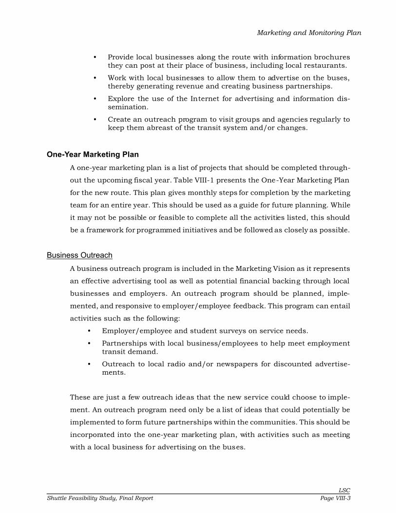
Marketing and Monitoring Plan
LSC
Shuttle Feasibility Study, Final Report Page VIII-3
• Provide local businesses along the route with information brochuresthey can post at their place of business, including local restaurants.
• Work with local businesses to allow them to advertise on the buses,thereby generating revenue and creating business partnerships.
• Explore the use of the Internet for advertising and information dis-semination.
• Create an outreach program to visit groups and agencies regularly tokeep them abreast of the transit system and/or changes.
One-Year Marketing Plan
A one-year marketing plan is a list of projects that should be completed through-
out the upcoming fiscal year. Table VIII-1 presents the One-Year Marketing Plan
for the new route. This plan gives monthly steps for completion by the marketing
team for an entire year. This should be used as a guide for future planning. While
it may not be possible or feasible to complete all the activities listed, this should
be a framework for programmed initiatives and be followed as closely as possible.
Business Outreach
A business outreach program is included in the Marketing Vision as it represents
an effective advertising tool as well as potential financial backing through local
businesses and employers. An outreach program should be planned, imple-
mented, and responsive to employer/employee feedback. This program can entail
activities such as the following:
• Employer/employee and student surveys on service needs.
• Partnerships with local business/employees to help meet employmenttransit demand.
• Outreach to local radio and/or newspapers for discounted advertise-ments.
These are just a few outreach ideas that the new service could choose to imple-
ment. An outreach program need only be a list of ideas that could potentially be
implemented to form future partnerships within the communities. This should be
incorporated into the one-year marketing plan, with activities such as meeting
with a local business for advertising on the buses.

Marketing and Monitoring Plan
LSC
Page VIII-4 Shuttle Feasibility Study, Final Report
Review Passenger Information
Reviewing passenger information regularly to make sure that brochures, flyers,
and other passenger information are kept up-to-date and current is a vital part of
a short-term marketing vision. Incorrect or outdated information which is provided
to customers is a sure way to decrease ridership. Information should be concise,
clear, and available if it is to be effective. Regular review of these promotional or
informational materials will promote service as a reliable transit opportunity.
Customer Surveys
Customer surveys should be done at least every three years. Customer surveys
require that a survey be designed that asks the important questions which help
to improve transit service. Questions should inquire into service delivery, destina-
tions, income, reason for riding, and perceptions of areas such as driver friendli-
ness, cleanliness of the buses, fare information, timeliness, etc. Surveys are an
important measure of service performance. If you don’t know the perceptions of
the clientele you are serving, how can you effectively serve them? The way to
measure these perceptions is to survey them.

Month One Activities
1 Establish a Marketing Team comprised of local staff.
2 Develop new brochure on services.
3 Visit local businesses to promote the service.
4 Identify possible outreach events.
5 Establish marketing goals for the Town of Winter Park.
Month Two Activities
1 Identify and begin planning for an upcoming community event.
2 Investigate advertising costs on local radio stations.
3 Identify those businesses and agencies that are interested in advertising.
4 Develop a promotional kit for transportation programs available in the Fraser Valley.
Month Three Activities
1 Attend a local community event with handouts, free daily passes, etc.
2 Advertise on a local radio station.
3 Hold a "Shopping Day" offering a communitywide shopping trip for senior citizens free of charge.
Month Four Activities
1 Publish article in local news about community benefits of transit.
2 Contact two employers or agencies regarding the local transit service.
3 Visit with local business/retailer to educate employees/employers on the transit system.
Month Five Activities
1Visit local agencies and senior centers to discuss joint ventures to include promotional days and possible joint sponsorship of area trips.
2 Prepare human interest stories about benefits to individuals using services.
3 Hold a "Bus Riding Training Day" following a Seniors' Luncheon.
Month Six Activities
1 Hold Marketing Team six-month meeting.
2Evaluate current marketing strategies to be sure the Town is "on-target" and accomplishing marketing goals.
3 Contact two employers or agencies regarding the local transit service.
4 Establish the following year's marketing budget.
Month Seven Activities
1 Advertise on a local radio station.
2 Visit with local schools to plan additional events.
Month Eight Activities
1 Update the website with transit information.
2 Contact two employers or agencies regarding a bus pass program.
Month Nine Activities
1 Start "Thrifty Thursday" with general public fares lowered to 25 cents for that month's Thursdays.
2 Contact two employers or agencies regarding the local transit service.
3 Quarterly Marketing Team meeting.
Month Ten Activities
1 Distribute "Transit Rider Guide."
2 Contact two employers or agencies regarding the local transit service.
3Evaluate the success of the marketing program efforts in the form of surveys and boarding counts to determine if these market segments have increased over past years' ridership levels.
Month Eleven Activities
1Hold a children's art contest where children can compete for small prizes for designing a transit-related picture or painting. Coordinate with schools to promote the program.
2 Hang children's art in buses behind plexiglass for public viewing.
Month Twelve Activities
1 Hold Marketing Team year-end meeting.
2 Evaluate overall marketing successes and failures for future marketing plans.
STEPS
STEPS
STEPS
STEPS
STEPS
STEPS
STEPS
STEPS
Table VIII-1
One-Year Marketing Plan
STEPS
STEPS
STEPS
STEPS

Marketing and Monitoring Plan
LSC
Page VIII-6 Shuttle Feasibility Study, Final Report
(This page intentionally left blank.)
Marketing and Monitoring Plan
LSC
Shuttle Feasibility Study, Final Report Page VIII-7
Website
Much of the information in this section is taken from Transit Cooperative Research
Program, Synthesis 43, Effective Use of Transit Websites. It is recommended that
this information be included in the Commerce City, Stapleton, Dick’s Sporting
Goods Park, and RMANWR websites. In general, this report finds that transit
patrons are primarily interested in basic customer service information such as
maps, schedules, fares, and general service information. Based on LSC’s past
experience with website development, it was found that complicated pages, which
take an overwhelming amount of time to load and refresh, drive customers away.
Internet connection speeds vary and therefore it is recommended that the future
site be simple in design with only essential information provided. The more com-
plicated a website is to navigate, the more difficult it is for a user to obtain infor-
mation.
However, there are some essential design elements which should be incorporated
to make this site effective:
• Fares• Schedules• Maps• Accessibility information• Paratransit information• Purchasing passes• Public involvement information• Contact information
The main benefits of a website are making the schedule, maps, and passenger
information readily available. Other benefits include attracting new customers,
improving the agency’s image in the community, increasing ridership among exist-
ing patrons, and providing information for public involvement.
Key to site navigability are:
• Put important information at the top of a page.
• Group related information.
• Give greatest visibility to the information most often requested, such asschedule, fare information, service area, and contact information.
• Don’t make visitors search or dig for important information.

Marketing and Monitoring Plan
LSC
Page VIII-8 Shuttle Feasibility Study, Final Report
• Place navigation elements on the left side of the screen, which could berepeated on every page to keep track of where they are on the site.
• Keep pages consistent in design, such as logo placement and contactinformation.
• Have the website reviewed by outside sources for ease of use. This couldbe in the form of a brief users’ workshop at a local civic group meetingor seniors’ luncheon.
PDF Files
While PDF files are great for some, others despise waiting for them to load or don’t
even have a PDF viewer. Care should be taken when considering the use of PDF
documents on the website. That is not to say they should not be used for specific
items such as printable route maps or system information. However, alternate
forms of the files should be done in something like HTML (text) format. That is to
say, if a PDF file is to be used, there should be an alternate file format for those
who are unable or unwilling to use the PDF formats.
Schedules and Maps
Many times transit agencies try to “squeeze” large schedules onto their web page.
This method does not make reading schedules online easy or pleasant. Schedules
should be made accessible in PDF and HTML formats. In either case, a printable
format should be designed so people can print schedules at their leisure. It is
imperative that if schedules change, they be updated immediately on the website.
Maps on an agency’s website are an excellent idea if done properly. Maps should
be clearly labeled and easy to read. Maps should have the major streets labeled
as well as stop locations. Many agencies use smart tags associated with stop
locations. A customer can click on a stop and be linked to information about that
stop, including the schedule for that particular stop.
Accessibility for Persons with Disabilities
A final note on website design is taking into consideration persons with visual
disabilities. A number of simple steps can make a website accessible to persons
with disabilities. These include the following:
• Providing a text equivalent of all graphical elements. For example, use of“ALT” (alternate) tags for graphical elements. Text alternatives make web

Marketing and Monitoring Plan
LSC
Shuttle Feasibility Study, Final Report Page VIII-9
pages accessible to screen readers, which are software programs thatconvert text into synthesized speech for blind or visually-impairedpersons.
• Designing web pages so that information conveyed with color is availablewithout color.
• Not causing the screen to flicker with a frequency greater than 2 Hz andlower than 5 Hz, which can induce seizures.
Following the above guidelines for website design should make for an effective site
to provide useful transit information to transit customers.
MARKETING BUDGET
According to the American Public Transit Association, transit providers typically
budget between 0.75 and 3.0 percent of their gross budget on marketing promo-
tions (excluding salaries). Although this is less than most private sector busi-
nesses, public sector organizations can rely more heavily on media support for
their public relations programs.
In reality, transit agencies must ask themselves questions such as, “Will we get
more riders with this campaign?” or “Will we get additional revenues from this
marketing effort?” or “Why should we advertise something we are losing money
operating?” Answers to these questions are subjective and may be influenced
politically or may be continual efforts toward a particular market segment. The
following provides some “rules of thumb” that may be used.

Marketing and Monitoring Plan
LSC
Page VIII-10 Shuttle Feasibility Study, Final Report
Mar ketin g bud get per pe ak vehic le = $800 to $1,200
Amount of line revenue generated for each marketing
dollar spent
= $13 to $16
Marketing budget per rider (excluding transfers) = $0.015 to $0.02
Amount per person in the service area = $0.22 to $0.25
3-5% of operating costs expended as follows:
Sala ries a nd/o r Con sultant Services 66%
Printin g Ma terials 19%
Advertising 7%
Merchandising 4%
Other Direct Expenses 4%
TOTAL 100%
Marketing Budget
A first-year annual budget of approximately $20,000 is anticipated for marketing
efforts to inform the community of the new local transit service. This would include
the cost of designing and printing brochures and website development. The sub-
sequent years may anticipate a marketing cost of approximately $11,000 annually.
The short-term budget should act as a guide for prioritizing marketing projects for
the service. There is a total marketing budget of approximately $42,000 for Fiscal
Years 2010-13. Table VIII-2 provides the three-year budget at an annual increase
of five percent.

Marketing and Monitoring Plan
LSC
Shuttle Feasibility Study, Final Report Page VIII-11
Table VIII-2
Marketing Budget
Marketing 3-Year Plan
Projects 2009/10 2010/11 2011/12
Brochure Production/Printing $ 3,500 $ 3,675 $ 3,859
Flyer Production/Printing $ 1,000 $ 750 $ 788
Radio Advertising $ 1,500 $ 750 $ 788
Print Advertising $ 2,500 $ 500 $ 525
Merchandising $ 750 $ 788 $ 827
W ebsite Design/Production $ 2,500 $ 200 $ 210
Special Promotions $ 1,000 $ 1,050 $ 1,103
Orientation Mate rials $ 1,000 $ 500 $ 525
Incentives $ 500 $ 525 $ 551
Direct Mailing $ 1,000 $ 500 $ 525
Pass Printing/Administration $ 1,500 $ 1,575 $ 1,654
Survey/Feedback $ 1,000 $ - $ -
Direct Sales/Contact with Businesses $ 1,200 $ 500 $ 525
TOTAL EXPENSES $ 18,950 $ 11,313 $ 11,878
Based upon 5% Annual Inflation Rate
Source: LSC, 2008.
MONITORING PROGRAM
Monitoring of service should continue on a daily basis with some recommendations
for how to change specific data collection procedures. Data collection is essential
to evaluate the service performance and to determine if changes should be made
in the service delivery. This section provides information on data collection, data-
bases, and standard reports which should be prepared. Data to be collected fall
into three basic categories—ridership data, on-time performance, and financial. If
it is decided that RTD will be contracted to provide the service, the contract should
state that RTD will provide these data.
Ridership
Passenger boarding data should be collected continually on a time-specific basis.
There is a trade-off between data collection efforts and the value of information. It
is just as easy to collect too much data as it is to collect insufficient data.

Marketing and Monitoring Plan
LSC
Page VIII-12 Shuttle Feasibility Study, Final Report
MDTs in use
Passenger boardings should be recorded daily by route, fare
category, and by trip. One goal all transit agencies should
strive for is the implementation of Intelligent Transportation
Systems, such as Mobile Data Terminals (MDT). Mobile
Data Terminals include features such as recording each
passenger by fare category as they board. This capability
should be programmed into the capability of the software as it is implemented.
Mobile Data Terminals also allow both data and voice communication between
operator and dispatcher. It is similar to having an alphanumeric pager on the
dashboard.
Passenger boarding data can also be collected using tally boards on the buses.
Sufficient buttons are required to record passengers in each fare category. A
driver’s log sheet should then be used to record the passenger counts at the end
of each trip. The drivers do not need to calculate the number of passengers for that
trip, but record the running total by fare category. As data are entered, the calcu-
lation of passengers on each trip can be made. An effective approach is to prepare
the driver’s log sheet for each of the drivers’ runs. This will provide preprinted route
and trip information, and the driver will need only to record the date and the
passenger count data.
• Twice each year, a full boarding and alighting count should be completed.If passenger boardings are counted using the MDTs and integrated withAutomatic Vehicle Location (AVL), the data can be recorded automatically.If it must be done manually, this is a more intense effort and will requirethe use of additional personnel. Passenger counts are recorded for pas-sengers boarding and alighting by stop for a full day. This informationrecords the passenger activity at individual stops and is useful to deter-mine if stops are appropriately placed and what amenities should beprovided. If a stop has little or no activity, it would not warrant a bench orshelter, and may not even be appropriate as a designated stop. Data col-lection forms should be prepared for each route showing the stops andproviding space to record the passenger counts.
• An onboard passenger survey should be conducted periodically. Werecommend that a survey be conducted six months after service changeshave been implemented. Following that, passenger surveys should beconducted at least every two years.

Marketing and Monitoring Plan
LSC
Shuttle Feasibility Study, Final Report Page VIII-13
On-Time Performance
With any transit system, it is important to monitor on-time performance. An on-
time performance goal should be established. For instance, an attainable on-time
goal of 95 percent for the service may be considered for system changes. Minor
adjustments to routes may be needed to ensure that schedules and headway
adherence can be maintained.
To record on-time performance, drivers should report actual arrival and departure
times at designated bus stops along the routes and at major stops. It should be
emphasized that drivers should not leave prior to a scheduled stop time in order
to make up time along a route. Leaving early could cause riders to miss a bus.
The dispatcher should then record this information so that the number of trips
running late can be determined. Again, this capability could be integrated with the
MDT and database system so that the data are entered directly by the driver. This
effort should continue for the first three months of service. After that, on-time data
should be checked randomly to ensure that performance remains acceptable.
Financial Data
The City of Commerce City should carefully track financial data. Accounts should
be kept so that separate costs can be tracked for each route. Financial data are
required to evaluate performance measures such as the operating cost per hour of
service and the cost per passenger-trip. Monthly budget sheets should be prepared
for Commerce City by RTD as well as updates given on any changes likely to occur
throughout the year.
Database Formats
Several options are available for storing the data. The recommended approach is
to set up databases in Microsoft Access to record passenger data. Example data-
bases and assistance can be provided. A separate database should be set up for
routine passenger data and a second for the boarding and alighting counts.
If the buses are equipped with MDTs, passenger count data can be entered directly
into the database by the driver. The touch screen capability will allow the driver to
Marketing and Monitoring Plan
LSC
Page VIII-14 Shuttle Feasibility Study, Final Report
record passenger boardings at each stop. This, combined with Automatic Vehicle
Location systems (AVL), can record the data automatically by stop, eliminating the
need for separate boarding and alighting counts. Similarly, drivers could report
their arrival at designated time points via the MDT, and the time could be recorded
automatically into a database for on-time performance. These capabilities should
be programmed into the new software capabilities as they are implemented. RTD
has equipped many of their buses with MDT and AVL devices and plan to have
their entire fleet equipped in the near future.
Onboard survey data can be entered into a database such as Access or a spread-
sheet program such as Excel.
Reporting
The Commerce City Planning Department should provide monthly performance
reports to City Council. The report should include performance data for the current
month, the same month in the previous year, year-to-date performance, and the
prior year-to-date performance. Information which should be reported includes
passenger boardings by route, passengers per revenue-hour by route, total passen-
gers by fare category, total passengers, and system passengers per revenue-hour.
Financial information should be reported including the operating cost and the cost
per passenger. The average fare should be calculated and reported based on fare
revenues and passenger counts.
Quarterly reports should be considered for providing recent trends and interim
performance data to elected officials, the public, and other stakeholders. Addi-
tionally, an annual report should be compiled and presented. The information for
these reports can be easily generated from the databases and the accounting
system.
Listed below are definitions and a recommended performance goal for Commerce
City Shuttle. The performance goals may need adjustment once the monitoring
program has been conducted for at least 12 months.

Marketing and Monitoring Plan
LSC
Shuttle Feasibility Study, Final Report Page VIII-15
Passengers/Hour: Number of total monthly and annual passengers divided by thecorresponding revenue-hours.
Passengers/Hour Performance Goal: A goal of six passengers per hour is recom-mended.
Passengers/Mile: Number of total annual passengers divided by the annualrevenue-miles.
Passengers/Mile Performance Goal: A goal of 0.7 passengers per mile is recom-mended.
Cost/Trip: Total expenses divided by total annual one-way trips.
Cost/Trip Performance Goal: A goal of $11.00 per trip is recommended.
Service/Road Calls: Vehicle breakdowns are inevitable. This measures the dis-tance traveled between mechanical breakdowns. Although frequent occurrencescan create disruptions in a transit system, it is important to track the frequencyand type of mechanical failures of each vehicle in addition to monitoring a fleet’sage. Monitoring of vehicle breakdowns is one method of reducing system dis-ruptions and may allow an agency to improve monitoring of vehicle replacementschedules and preventative maintenance practices. Data collection efforts shouldinclude date, time of day, type of failure, age of vehicle, vehicle number, vehiclemileage, and how the situation was rectified. Monitoring of these items will allowan agency to recognize repeated types of mechanical breakdowns; breakdownsrelated to vehicle type, age, or mileage; and assist with preventative maintenanceprograms. Wheelchair lift failures should also be monitored. Data should beincluded in the monthly report.
Service/Road Call Performance Goal: A goal of one road call every 15,000 milesis recommended.
Accidents/100,000miles: Measure of driver safety. Accidents must be defined asa standard.
Accidents/100,000 miles Performance Goal: A goal of 2.5 per 100,000 miles ofrevenue service is recommended.
Cost/Revenue-Hour: An excellent indicator of efficiency is cost per revenue-hourof service. Costs per hour should be analyzed by route and compared to overallsystem averages.
Cost/Revenue Hour Performance Goal: A goal of $65.00 per hour is recom-mended.

Chapter IX

LSC
Shuttle Feasibility Study, Final Report Page IX-1
CHAPTER IX
Strategic Implementation Plan
INTRODUCTION
LSC has prepared the following strategic implementation plan for the study area
in order to identify the steps to be taken now and in the future. Chapter IX in-
cludes the service plan and the implementation steps for each phase of the pre-
ferred transit service plan. LSC has also included organizational, capital, and
preliminary financial options to fund future services.
ORGANIZATIONAL PLAN
LSC recommends that the study area enhance its existing transit coordination
among the current stakeholders into a formal Coordinating Council. The number
of individual entities within the area will make establishment of a new organiza-
tion difficult, but using the existing Stakeholders Group as a basis, the likelihood
of success is high. A less formal cooperative organization is less appropriate and
does not allow for coordination and funding of a local service. This is particularly
important from a funding standpoint if other entities contribute to the service,
rather than Commerce City attempting to fund service alone. The financial options
will describe this Council in terms of funding match.
The Coordinating Council will need to determine the appropriate operators for new
services. Services should be contracted to an appropriate entity, likely RTD. There
do not appear to be sufficient financial resources for the local community to oper-
ate services in the area. A cooperative effort among the local communities and
RTD also has the potential to leverage more funding than if the study area
attempts to fund services independently. A coordinated application to RTD is likely
to gain more support for funding if it comes with the full support of the local
coordinated entities.

Strategic Implementation Plan
LSC
Page IX-2 Shuttle Feasibility Study, Final Report
The formation of the Coordinating Council should be derived from the local Stake-
holders Group, which has been involved throughout the process. This should be
established immediately. This group will be an informal organization which will
meet at least quarterly and more often if required for specific actions. The primary
role of the Coordinating Council will be to coordinate the funding allocation and
future services with RTD. Participation on the Coordinating Council should be
open to all local stakeholders in the area. Each of the organizations should be
encouraged to participate actively.
No staffing is anticipated for the Council. However, the Council should select a
chairperson to facilitate meetings and someone to take notes of meetings and
distribute them to the participants. These duties should be rotated on a periodic
basis.
A Memorandum of Understanding among the participants may be appropriate. The
Memorandum should outline the purpose of the Council and the rights and
responsibilities of each participant. Additionally, an Intergovernmental Agreement
(IGA) may be appropriate if funding allocations are to be made between partici-
pants to fund services.
SERVICE PLAN
This section describes the service to be provided in the near term. The proposed
service includes two fixed routes and appropriate ADA service. Chapter VII pro-
vided the Preferred Service Plan, including Figure VII-1 which presents the service
plan for operations. The following details the services to be provided, number of
vehicles, ridership, and expected costs to operate service. It should be mentioned
that at this point that costs are based upon allocated costs for RTD to operate the
service. There are no additional foreseeable administrative or overhead costs asso-
ciated with RTD adding an additional route in the area. Therefore, the costs
should be an accurate estimate for adding these services in the RTD area. How-
ever, based upon the recommendation that the study area communities will not
be purchasing vehicles, a portion of the operating costs may include leasing a
vehicle from RTD. At this point, the cost per hour of operations is likely as close
to reality as possible until the service plan is refined with RTD staff.

Strategic Implementation Plan
LSC
Shuttle Feasibility Study, Final Report Page IX-3
Description of Service
The recommended service plan is based upon existing RTD routes and the addi-
tion of one local circulator route from the Stapleton Transfer Station to the
Commerce City Civic Center, Dick’s Sporting Goods Park, and the Wildlife Refuge.
The route will operate from 6:00 a.m. to 10:00 p.m. during the weekdays, from
8:00 a.m. until 10:00 p.m. during the weekends, and during regularly scheduled
events at the stadium. Table IX-1 provides the service overview. This option also
reduces the duplication with the existing RTD Route 88.
Local paratransit service will be provided by the two counties and RTD as is done
currently.
Table IX-1
Preferred Short-Term Service Plan
Services Estimated
Cost
Estimated
Riders hip
W eekday Service $ 496,000.00 44,941
W eekend Service $ 206,336.00 19,982
Total $ 702,336.00 64,923
Fares
The proposed fares are set based on the existing fare structure as shown in Table
IX-2.
Table IX-2
Proposed Fare Structure
Local Circulator Fare CategoriesOne-Way
Cash F are
Cash $1.75
Discount Cash* $0.85
10-Ride Pass $15.75
Discount 10-Ride Pass $8.00
Monthly Pass $60.00
Discount Monthly Pass $30.00
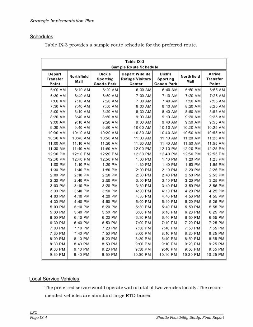
Strategic Implementation Plan
LSC
Page IX-4 Shuttle Feasibility Study, Final Report
Schedules
Table IX-3 provides a sample route schedule for the preferred route.
Table IX-3
Sam ple Ro ute Sc hedu le
Depart
Transfer
Point
North field
Mall
Dick's
Sporting
Good s Park
Depart Wildlife
Refuge Visitors
Center
Dick's
Sporting
Good s Park
North field
Mall
Arrive
Transfer
Point
6:00 AM 6:10 AM 6:20 AM 6:30 AM 6:40 AM 6:50 AM 6:55 AM
6:30 AM 6:40 AM 6:50 AM 7:00 AM 7:10 AM 7:20 AM 7:25 AM
7:00 AM 7:10 AM 7:20 AM 7:30 AM 7:40 AM 7:50 AM 7:55 AM
7:30 AM 7:40 AM 7:50 AM 8:00 AM 8:10 AM 8:20 AM 8:25 AM
8:00 AM 8:10 AM 8:20 AM 8:30 AM 8:40 AM 8:50 AM 8:55 AM
8:30 AM 8:40 AM 8:50 AM 9:00 AM 9:10 AM 9:20 AM 9:25 AM
9:00 AM 9:10 AM 9:20 AM 9:30 AM 9:40 AM 9:50 AM 9:55 AM
9:30 AM 9:40 AM 9:50 AM 10:00 AM 10:10 AM 10:20 AM 10:25 AM
10:00 AM 10:10 AM 10:20 AM 10:30 AM 10:40 AM 10:50 AM 10:55 AM
10:30 AM 10:40 AM 10:50 AM 11:00 AM 11:10 AM 11:20 AM 11:25 AM
11:00 AM 11:10 AM 11:20 AM 11:30 AM 11:40 AM 11:50 AM 11:55 AM
11:30 AM 11:40 AM 11:50 AM 12:00 PM 12:10 PM 12:20 PM 12:25 PM
12:00 PM 12:10 PM 12:20 PM 12:30 PM 12:40 PM 12:50 PM 12:55 PM
12:30 PM 12:40 PM 12:50 PM 1:00 PM 1:10 PM 1:20 PM 1:25 PM
1:00 PM 1:10 PM 1:20 PM 1:30 PM 1:40 PM 1:50 PM 1:55 PM
1:30 PM 1:40 PM 1:50 PM 2:00 PM 2:10 PM 2:20 PM 2:25 PM
2:00 PM 2:10 PM 2:20 PM 2:30 PM 2:40 PM 2:50 PM 2:55 PM
2:30 PM 2:40 PM 2:50 PM 3:00 PM 3:10 PM 3:20 PM 3:25 PM
3:00 PM 3:10 PM 3:20 PM 3:30 PM 3:40 PM 3:50 PM 3:55 PM
3:30 PM 3:40 PM 3:50 PM 4:00 PM 4:10 PM 4:20 PM 4:25 PM
4:00 PM 4:10 PM 4:20 PM 4:30 PM 4:40 PM 4:50 PM 4:55 PM
4:30 PM 4:40 PM 4:50 PM 5:00 PM 5:10 PM 5:20 PM 5:25 PM
5:00 PM 5:10 PM 5:20 PM 5:30 PM 5:40 PM 5:50 PM 5:55 PM
5:30 PM 5:40 PM 5:50 PM 6:00 PM 6:10 PM 6:20 PM 6:25 PM
6:00 PM 6:10 PM 6:20 PM 6:30 PM 6:40 PM 6:50 PM 6:55 PM
6:30 PM 6:40 PM 6:50 PM 7:00 PM 7:10 PM 7:20 PM 7:25 PM
7:00 PM 7:10 PM 7:20 PM 7:30 PM 7:40 PM 7:50 PM 7:55 PM
7:30 PM 7:40 PM 7:50 PM 8:00 PM 8:10 PM 8:20 PM 8:25 PM
8:00 PM 8:10 PM 8:20 PM 8:30 PM 8:40 PM 8:50 PM 8:55 PM
8:30 PM 8:40 PM 8:50 PM 9:00 PM 9:10 PM 9:20 PM 9:25 PM
9:00 PM 9:10 PM 9:20 PM 9:30 PM 9:40 PM 9:50 PM 9:55 PM
9:30 PM 9:40 PM 9:50 PM 10:00 PM 10:10 PM 10:20 PM 10:25 PM
Local Service Vehicles
The preferred service would operate with a total of two vehicles locally. The recom-
mended vehicles are standard large RTD buses.

Strategic Implementation Plan
LSC
Shuttle Feasibility Study, Final Report Page IX-5
Service Summary
The annual cost for transit service is approximately $700,000 based upon existing
estimates from RTD. The estimated ridership is 65,000 passengers annually. This
results in a cost per passenger-trip of $11.00. Following is a summary of the
estimated additional costs and passengers for the transit service:
• $11.00 cost per passenger-trip for all services
• $700,000 annual cost
• 6.0 passengers per hour
Benefits
• Residents will obtain increased connectivity and mobility in the area.
• Visitors will be provided an opportunity to use bus service to access thekey destinations without reliance on personal automobile.
• Reduction in vehicle traffic at Dick’s Sporting Goods Park.
Responsibility
• The Coordinating Council will be responsible for planning and imple-menting the preferred transit service plan for the study area.
• RTD will train the bus drivers on the operations of the new service.
• The Coordinating Council should establish fares which are similar toexisting RTD fares.
• The Coordinating Council will be responsible for developing a fair costallocation for generation of revenue.
• The stakeholders should develop an educational program for the newservice at least three months before the service changes are imple-mented. This should include public meetings to inform the public aboutthe new transit service and allow for public comments.
• RTD should conduct test runs of the proposed service and make anynecessary changes to the schedules.
FINANCIAL OPTIONS
This section presents preliminary financial plan options for the next five years for
the preferred transit service plan. This section presents the expenditures and

Strategic Implementation Plan
LSC
Page IX-6 Shuttle Feasibility Study, Final Report
revenues for the area for the years 2010 through 2014, with the assumption of an
annual eight percent inflation rate.
In 1973 citizens voted overwhelmingly for RTD’s plan to finance
the development of an integrated regional public transportation
system. After a little more than three years of operating public
transportation in Denver as Denver Metro Transit, the system
became part of RTD in 1974. RTD receives FTA Section 5307 as
part of the designated urban area. LSC recommends that the Coordinating Council
work with RTD to develop a reasonable cost of services which uses Section 5307
allocation to support these services. Since the area is part of the RTD service area,
these would be additional services which would be eligible under the FTA Section
5307 funding allocation to the urban area. The 5307 funding is a reimbursable
amount based upon maintenance costs to operate service. The remainder is then
local funding; however, RTD is already providing service in the area, so this expan-
sion would need to be coordinated with RTD.
The LSC team has developed financial plans based upon several assumptions of
potential sources. The financial plans are presented in Tables IX-4 and IX-5. These
financial plans include an eight percent annual rate of inflation to compensate for
the increasing fuel cost over the past few years, as the fuel cost will continue to
impact operational costs for all transit systems. The financial plan options are as
follows:
• Option I: Fares and Local Funds
• Option II: Fare and Equitable Allocation of Local Funds
It has been assumed that the full operating costs include the necessary vehicles
as part of the contract negotiation process with RTD.

Table IX-4Option I: Local/User Funded
OPERATIONS/ADMIN/MAINTENANCE 2009 2010 2011 2012 2013Route Operations 702,400$ 758,600$ 819,300$ 884,900$ 955,700$
Total 702,400$ 758,600$ 819,300$ 884,900$ 955,700$ ANNUAL FUNDING
Fares (10% Farebox Recovery) 70,240$ 73,752$ 77,440$ 81,312$ 85,377$ Local Funding 632,160$ 684,848$ 741,860$ 803,588$ 870,323$
Total 702,400$ 758,600$ 819,300$ 884,900$ 955,700$ Note: 8% operating cost inflation used, 5% ridership increases annually
Table IX-5Option II: Allocated Costs
OPERATIONS/ADMIN/MAINTENANCE 2009 2010 2011 2012 2013Route Operations 702,400$ 758,600$ 819,300$ 884,900$ 955,700$
Total 702,400$ 758,600$ 819,300$ 884,900$ 955,700$ FUNDING
Fares (10% Farebox Recovery) 70,240$ 73,752$ 77,440$ 81,312$ 85,377$ Commerce City 210,720$ 228,283$ 247,287$ 267,863$ 290,108$ Stapleton 210,720$ 228,283$ 247,287$ 267,863$ 290,108$ Rocky Mountain Arsenal/Wildlife Refuge 210,720$ 228,283$ 247,287$ 267,863$ 290,108$
Total 702,400$ 758,600$ 819,300$ 884,900$ 955,700$ Note: 8% operating cost inflation used, 5% ridership increases annually
LS
C
Sh
uttle
Fea
sib
ility S
tud
y, F
ina
l Report
Pa
ge IX
-7
Strategic Implementation Plan
LSC
Page IX-8 Shuttle Feasibility Study, Final Report
SHORT-TERM IMPLEMENTATION PLAN
A brief short-term implementation plan is presented in this section. Specific
actions with corresponding responsibilities and timing are described. This imple-
mentation plan represents data from previous sections of this chapter and pro-
vides guidance for future efforts for public transit service.
Formalize Transit Council
The first step is to formalize the transit council so that funding allocations can be
determined and decisions made. This should happen immediately. Memoranda of
Understanding and IGAs will need to be developed.
Create a Budget and Secure Funding for Services
The next step is to determine an equitable cost allocation, as detailed in the finan-
cial options section of this chapter. A financial account should be established in
the name of the Transit Council. Much of this could potentially be handled
through the Commerce City Accounting Department with the addition of a Transit
Account. Additionally, once a budget for services has been established, this
account should be used to fund the local match portion of services under contract
with RTD.
Obtain Funding
Funding must be established for implementation of the new
services. The stakeholders currently have a strong relationship
for the potential funding of services. This should continue with
allocation based upon dedication toward the system in terms of
funding from individual entities. The City will have to work diligently with the area
stakeholders if the decision is made to allocate costs. Additional sources of
revenues should be explored from various social service agencies which currently
provide their own transportation service as well as the local businesses.
Timing
The Coordinating Council should begin development of funding immediately. Final
budgets should be developed after the funding is obtained.

Strategic Implementation Plan
LSC
Shuttle Feasibility Study, Final Report Page IX-9
Responsibility
Funding will be a primary role for the City. Final budget items will be approved by
City Council and other boards.
Finalize Service Plan
The operating plan for the service must be finalized prior to implementation. This
will include identification of the exact routes and stops. The service schedule will
be finalized indicating the specific stops and scheduled times for the service.
Timing
The service plan should be finalized six months prior to the date established to
begin service.
Responsibility
The Coordination Council, working with RTD, will finalize the service plan, route,
and timings.
Develop Contract with RTD
Once the service plan is approved and refined, an operating contract with RTD will
need to be completed. This contract would be between Commerce City and RTD.
Timing
The contracts should be drafted as soon as possible. Contracts need multiple
approvals from City and RTD attorneys and the City Council.
Responsibility
Commerce City and RTD will be responsible for developing the contract.
Develop Marketing/Promotional Materials
Marketing and promotional materials will be needed to publicize the new type of
service to be offered in the area. The best marketing that can be done is to provide
services that people want. Many of the actions discussed in this Implementation
Program are a part of marketing. Providing high quality service is an element of

Strategic Implementation Plan
LSC
Page IX-10 Shuttle Feasibility Study, Final Report
marketing because it provides a desirable service to those who will use it. In order
to provide good service, it is essential to have information which may be used by
management for evaluation of the service and continuous improvement of that
service. The area must maintain a customer orientation in every part of the plan.
Several specific promotion activities have been identified which will enhance the
overall implementation and marketing efforts.
• Brochures should describe the services and include a map of the area to beserved. The brochures should include the schedule with times shown for eachdesignated stop.
• Posters and signs should be prepared which may be displayed in businesses,at places of employment, hospitals, and community bulletin boards. The signsor posters should provide a brief description of the service with a source toobtain additional information. If possible, the schedule brochures should bemade available where the posters are displayed.
• A speakers’ bureau made up of members of the Coordination Council shouldbe provided for community and civic groups, as well as other interestedparties. A standard presentation could be developed using display boards ora computer slide show which could be used by all of the speakers.
• Announcements should be made through local media such as newspapersand radio. Articles should be written and submitted to the local news mediadescribing the new service with information about when the service will start,why it is being provided, what people must do to use the service, how it willbe funded, and any other information of general interest.
• Publicity should also be sought when the service begins. News releasesshould be given to the local news media describing the start-up of the newservice.
• The use of RTD publication and promotion should be made. Additionally,information should be posted on the RTD website.
Timing
Brochures, signs, and posters should be prepared three months prior to imple-
mentation. Signs and posters should be displayed one month before beginning
new services with information about the start date. Speaking engagements should
begin immediately to develop support for the service.
Strategic Implementation Plan
LSC
Shuttle Feasibility Study, Final Report Page IX-11
Responsibility
RTD should have the primary responsibility for preparation of the materials with
assistance from other staff and the Council. This should be budgeted into the first
year of operations. RTD has the capability to provide in-house marketing for the
area.
Begin Services
Services should begin in mid-2009.
RECOMMENDED ADDITIONAL PLANS AND STUDIES
LSC has developed a short list of additional studies and plans that Commerce City
will need to conduct over the next few years:
• Onboard survey and analysis of the new service in order to identify possibleadjustments to the transit service to combine with Title VI requirements formonitoring the system.
• Detailed passenger boarding and alighting counts.