Shoalhaven Hydro Expansion Project - Origin Energy · The Shoalhaven Hydro Expansion Project,...
96
Shoalhaven Hydro Expansion Project Origin Energy Eraring Pty Ltd Geotechnical Investigation - Response to Submissions IA193700-0100-EN-RPT-006 | 1 10 April 2019
Transcript of Shoalhaven Hydro Expansion Project - Origin Energy · The Shoalhaven Hydro Expansion Project,...

Shoalhaven Hydro Expansion Project
Origin Energy Eraring Pty Ltd
Geotechnical Investigation - Response to Submissions
IA193700-0100-EN-RPT-006 | 1
10 April 2019
Geotechnical Investigation - R esponse to Submissi ons Origin Energ y Eraring Pty Ltd

Geotechnical Investigation - Response to Submissions
IA193700-0100-EN-RPT-006 i
Shoalhaven Hydro Expansion Project
Project No: IA193700
Document Title: Geotechnical Investigation - Response to Submissions
Document No.: IA193700-0100-EN-RPT-006
Revision: 1
Date: 10 April 2019
Client Name: Origin Energy Eraring Pty Ltd
Client No:
Project Manager: Mike Luger
Author: Thomas Muddle
File Name: J:\IE\Projects\04_Eastern\IA193700\Geotech EIS\IA193700_Origin_Shoalhaven Pumped
Hydro_Geotech Investigations_RtS_rev1.docx
Jacobs Group (Australia) Pty Limited
ABN 37 001 024 095
Level 7, 177 Pacific Highway
North Sydney NSW 2060 Australia
PO Box 632 North Sydney
NSW 2059 Australia
T +61 2 9928 2100
F +61 2 9928 2444
www.jacobs.com
© Copyright 2019 Jacobs Group (Australia) Pty Limited. The concepts and information contained in this document are the property of Jacobs. Use
or copying of this document in whole or in part without the written permission of Jacobs constitutes an infringement of copyright.
Limitation: This document has been prepared on behalf of, and for the exclusive use of Jacobs’ client, and is subject to, and issued in accordance with, the
provisions of the contract between Jacobs and the client. Jacobs accepts no liability or responsibility whatsoever for, or in respect of, any use of, or reliance
upon, this document by any third party.
Document history and status
Revision Date Description By Review Approved
1 10/04/2019 Final Report form TM LB ML

Geotechnical Investigation - Response to Submissions
IA193700-0100-EN-RPT-006 ii
Contents
1. Background ....................................................................................................................................... 1
2. Project Overview .............................................................................................................................. 1
3. Assessment Process ....................................................................................................................... 1
4. Submissions ..................................................................................................................................... 1
4.1 Public Feedback - Submission number 315472 ................................................................................. 2
4.2 NSW Department of Planning & Environment – Division of Resources & Geoscience, Geological Survey of New South Wales Comment .............................................................................................. 2
4.3 RMS Comments ................................................................................................................................. 2
4.4 OEH Submissions .............................................................................................................................. 4
4.4.1 Impacts to Morton National Park ........................................................................................................ 4
4.4.2 Biodiversity ......................................................................................................................................... 4
4.4.3 Heritage .............................................................................................................................................. 6
4.5 Shoalhaven Council Comment ........................................................................................................... 7
4.6 Environmental Protection Authority Comment ................................................................................... 7
4.7 Department of Industry Comment ...................................................................................................... 7
4.8 WaterNSW Comment ......................................................................................................................... 9
4.9 RFS Comment .................................................................................................................................... 9
5. Conclusions .................................................................................................................................... 10
Appendix A. Shoalhaven Hydro Expansion Project – Geotechnical Investigations Biodiversity Development Assessment Report Revision 2

Geotechnical Investigation - Response to Submissions
IA193700-0100-EN-RPT-006 1
1. Background
Origin Energy Eraring Pty Ltd (a subsidiary of Origin Energy Limited) (collectively, Origin) is the current operator
of the Shoalhaven Pumped Hydro Energy Storage Scheme (the existing scheme). The existing scheme is
located in the New South Wales (NSW) Southern Highlands, approximately 150km south east of Sydney. The
existing scheme was commissioned in 1977 and currently has a generating capacity of 240MW. Origin now
proposes to almost double the electricity generation capacity of the existing scheme with the Shoalhaven Hydro
Expansion Project, which will provide approximately an additional 235MW of pumped storage generation
capacity. Origin has completed a pre-feasibility study and is now undertaking a feasibility study for the
Shoalhaven Hydro Expansion Project. To confirm the feasibility of the Shoalhaven Hydro Expansion Project,
geotechnical investigations are required to provide confidence that the below ground structures can be
constructed and operated safely and cost effectively.
The Shoalhaven Hydro Expansion Project, including geotechnical investigations, was declared to be State
significant infrastructure and critical State significant infrastructure (CSSI) by an amendment made to the State
Environmental Planning Policy (State and Regional Development) 2011 (SRD SEPP) on 14 December 2018.
An Environmental Impact Statement (EIS) for the Project was publicly exhibited from 22 February 2019 to 23
March 2019. This letter responds to the submissions made in relation to the Project.
2. Project Overview
The geotechnical investigations are proposed on land owned by WaterNSW associated with the existing
Kangaroo Valley and Bendeela Power Stations and water transfer operations. Locations 1, 2, 7 and 8 are
positioned in currently cleared areas with evidence of prior ground disturbance and with existing established
access tracks. Locations 3, 4 and 5 are positioned within areas previously cleared for agricultural purposes that
have revegetated naturally following the exclusion of agriculture. Location 6 is within an area that appears to be
have been partially cleared and subsequently naturally revegetated. Access to borehole locations 3, 4, 5 and 6
would require limited clearing of shrubs to ground level to establish approximately 500 metres of temporary
access tracks up to two-metre-wide to facilitate the access of drill rigs, and daily travel of support vehicles and
utility vehicles. No excavation of the ground surface would be undertaken, and large, mature vegetation and
other habitat features will be avoided.
3. Assessment Process
The Project was declared to be Critical SSI for the purpose of the EP&A Act on 14 December 2018. Origin
lodged a State significant infrastructure application report with the Department of Planning and Environment
(DP&E) on 18 December 2018 and was issued with Environmental Assessment Requirements (EARs) on 25
January 2019. In preparing the EARs, the DP&E received input from each of the Environment Protection
Authority (EPA), Office of Environment and Heritage, WaterNSW and Shoalhaven Council.
The EIS was prepared to address these EARs and was placed on public exhibition for four weeks, between 22
February 2019 and 23 March 2019, during which time submissions were invited. The submissions received
were collated by the DP&E and provided to Origin for review and response.
4. Submissions
The following submissions were received in relation to the Project:
• Submissions, categorised as comments, were received from eight government agencies; and
Geotechnical Investigation - Response to Submissions
IA193700-0100-EN-RPT-006 2
• 1 submission, categorised as an objection, was received from a member of the general public.
The following sections respond to each submission.
4.1 Public Feedback - Submission number 315472
One objection was received from the public during the exhibition period. This submission consists of a general
objection to pumped hydro and suggested alternatives in terms of electricity generation and storage. The full
submission is available at
http://majorprojects.planning.nsw.gov.au/?action=view_submission&job_id=9816&submission_id=315472
The submission does not relate to the geotechnical investigations, and does not contain any explicit objection to
the geotechnical investigations. The issues and alternatives raised will be considered as part of the main works
EIS.
4.2 NSW Department of Planning & Environment – Division of Resources & Geoscience, Geological Survey of New South Wales Comment
Thank you for the opportunity to provide advice on the above matter. This is a response from NSW Department
of Planning & Environment – Division of Resources & Geoscience, Geological Survey of New South Wales
(GSNSW).
GSNSW has reviewed the Environmental Impact Statement (EIS) for the Shoalhaven Hydro Expansion Project
within the Shoalhaven LGA. As the study area does not preclude access to known resources or exploration for
future resource discovery and extraction, and there are no intended biodiversity offsets for the project, GSNSW
has no concerns or issues to raise in relation to resource sterilisation at this stage.
Comment noted.
4.3 RMS Comments
RMS provided two submissions during the exhibition period, the first requesting additional information and the
second providing comment on the additional information as follows:
Comment 1:
RMS has reviewed the provided information, focussing on the impact to the state road network. RMS notes for
this application:
• The key state road is Moss Vale Road;
• Access to sites 1 & 2 from Moss Vale Road are via the existing intersection with the Promised Land Trail;
• Access to sites 3-8 from Moss Vale Road are via the intersection Bendeela Road; and
• The proposed borehole locations in the attached plan.
It is unclear whether the existing intersection of Moss Vale Road and the Promised Land Trail can
accommodate storage of the largest vehicle (or number of vehicles if arriving/leaving at one time) requiring
access, clear of the through lanes of Moss Vale Road, while the access gate is being opened or closed. RMS

Geotechnical Investigation - Response to Submissions
IA193700-0100-EN-RPT-006 3
requires clarification of how access at this location will be safely managed with minimal impact to the through
traffic on Moss Vale Road.
Comment 2:
Roads and Maritime Services (RMS) refers to correspondence received from Mike Luger of Jacobs (see
attachment A) dated 21 March 2019 regarding RMS’ response to the subject State Significant Infrastructure.
RMS has reviewed the additional information provided and notes the following:
• There is approximately 21m of storage space available at the intersection of Moss Vale Road and the
Promised Land Trail.
• Prior to any large vehicle arriving, the site manager will open the gate located on the Promised Land Trail
to ensure the heavy vehicle can continue onto the Trail, without needing to store in the abovementioned
storage area.
Given the sight distance available at the intersection of Moss Vale Road and the Promised Land Trail is less
than the required Safe Intersection Sight Distance (SISD), as outlined in Austroads Guide to Road Design Part
4A, RMS considers a Traffic Management Plan (TCP) should be in place to manage the risks associated with
the identified heavy vehicle access at this location. Having regard for the above, RMS will not object the
application subject to the following being included in the conditions of any development consent issued:
• A Traffic Management Plan (TMP) to manage the impact of the heavy vehicle accessing the site via the
intersection of Moss Vale Road and The Promised Land Trail shall be developed in consultation with RMS
Southern Traffic Operations Unit and Council’s Local Traffic Committee (LTC). The TMP (and associated
Traffic Control Plans) shall be submitted to Council’s LTC for final acceptance.
• A copy of the accepted TMP shall be forwarded to RMS (via [email protected]) prior
to any transportation occurring or works commencing on site for this development
RMS highlights that in determining the DA under Part 4 of the Environmental Planning and Assessment Act,
1979, it is the consent authority's responsibility to consider the environmental impacts of any road works which
are ancillary to the development. This includes any works which form part of the proposal and/or any works
which are deemed necessary to include as requirements in the conditions of development consent (i.e. insert).
Depending on the level of environmental assessment undertaken to date and nature of the works, the consent
authority may require the developer to undertake further environmental assessment for any ancillary road
works.
Since the completion of the geotechnical investigation EIS, and correspondence of 21 March between Jacobs
and RMS, a preferred drilling contractor has been selected and specific information on the truck to be used to
transport the drill rig to be used to progress the borehole accessed from the Promised Land Trail has been
obtained. The truck will be approximately 11.8m long and with the drill rig will have a combined weight of
approximately 18 tonnes.
The drilling contractor has also confirmed that they can access the Promised Land Trail from the south so that
they can turn left onto the Promised Land Trail. This arrangement would negate the less desirable right turn
movement. The truck could also turn left when leaving the Promised Land Trail to again achieve a better safety
outcome. Additionally, the risk could further be mitigated through the provision of a spotter on each of the
approaches. In light of the above, the road safety risk associated with the delivery and recovery of the drill rig is
considered to be low.
In the absence of this specific information, the EIS adopted a “worst case” approach in assessing road safety
risks leading to identification of the potential need for mitigation measures that would have required the
consideration and approval of RMS Southern Traffic Operations Unit and Shoalhaven Traffic Committee as per
RMS delegated authority under the Transport Administration Act 1988. With the confirmation of smaller than
anticipated delivery vehicles and alternative available route the need for these mitigation measures has been
removed.

Geotechnical Investigation - Response to Submissions
IA193700-0100-EN-RPT-006 4
A Traffic Management Plan will still be prepared outlining the route to be taken for delivery and removal of the
drilling rig, including discussion of origin/destination and identification of a safe location for the transport vehicle
to turn around (if required). Similarly, the abovementioned would also be identified for the daily light vehicle
movements. RMS has confirmed that the TMP will not require approval of Council Local Traffic Committee.
For avoidance of doubt, the project does not seek approval under Part 4 of the Environmental Planning and
Assessment Act 1979 and instead is to be determined under Part 5.1 as State significant infrastructure by the
Minister for Planning.
4.4 OEH Submissions
4.4.1 Impacts to Morton National Park
We note that access across the Promised Land track within Morton National Park is the only aspect of the
geotechnical explorations project occurring on NPWS land. Access across locked WaterNSW lands will also be
required. No boreholes or associated staging works are proposed on-park. Access arrangements within the
Morton NP for Origin contractors are already in place and administered at the time of each entry.
Conditions of access include no dogs or firearms within the Morton NP, ensuring that gates are closed and
locked after access and prohibiting entry and after rain until roads can be used without causing damage.
Our preferred approach for the geotechnical explorations project is that the existing access arrangements are
utilised. It is anticipated that, prior to the more extensive period of access for the expansion project (which may
involve physical works such as track widening, vegetation trimming on-park and the like), a licence for access
under the National Parks & Wildlife Act 1974 will be issued.
Comment noted and Origin will continue to comply with existing access arrangements.
4.4.2 Biodiversity
We have reviewed the Biodiversity Development Assessment Report (BDAR) prepared in support of the EIS.
The BDAR states that the 0.21 ha of proposed vegetation clearing does not trigger the 0.25ha threshold above
which offsets are required. However, the clearing thresholds applicable for development assessed under Part 4
of the Environmental Planning & Assessment Act 1979 are not relevant for SSD/SSI projects. Under s7.14 of
the Biodiversity Conservation Act 2016, impacts for major projects are required to be offset unless a BDAR
waiver is granted (generally at SEARs stage). Therefore, the biodiversity credit liability calculated by the BDAR
will need to be offset and credit retirement provided for by way of condition.
We also note that the BDAR has included a number of species credit species as potentially present in the
suitability assessment, identifying these as "not excluded". As per the above comments, offsets for the project
will need to be provided. However, taking account of the streamlined assessment pathway, we support offsets
being provided for the ecosystem credits only in this case, given the fairly minimal impact upon species credit
species. The BDAR will need to be updated to reflect this. Finally, we also note that the online BAM calculator
will need to be submitted online and reviewed by our office at or prior to Response To Submissions stage.
It is acknowledged that the application of the offset scheme thresholds has been misinterpreted and that in the
absence of the offset scheme threshold S7.14 applies to an application for approval for State significant
infrastructure under Part 5.1 of the EP&A Act that is required to be accompanied by a biodiversity development
assessment report (BDAR). The credit calculation has been provided below and the updated BDAR is attached.
In determining the number of biodiversity credits in the online BAM calculator, additional biodiversity survey
effort has been completed in the broader study area for the Shoalhaven Hydro Expansion Project Main Works
and this has better informed plant community type classification. As a result, this information has indicated the

Geotechnical Investigation - Response to Submissions
IA193700-0100-EN-RPT-006 5
absence of Forest Red Gum - Thin-leaved Stringybark grassy woodland on coastal lowlands, southern Sydney
Basin Bioregion (PCT 838) and associated Illawarra Lowlands Grassy Woodland in the Sydney Basin Bioregion
TEC (BC Act and EPBC Act) in the study area. Previously this classification relied on data from a single floristic
plot which showed a dominance of Thin-leaved Stringybark (Eucalyptus eugenioides) and a lack of mid-storey
structure which was likely related to past logging disturbance. Broader searches and floristic plots in the same
vegetation community have indicated that Thin-leaved Stringybark co-dominates with Turpentine (Syncarpia
glomulifera), Red Bloodwood (Corymbia gummifera) and Sydney Peppermint (Eucalyptus pipertia) with a mesic
understorey species consistent with the Southern Lowland Wet Sclerophyll forests vegetation class and
representative of Turpentine - Red Bloodwood - Sydney Peppermint shrubby open forest on the foothills,
southern Sydney Basin Bioregion and northern South East Corner Bioregion (PCT 1283).
The online BAM calculator was interrogated to measure the total change in vegetation integrity (future value
scores) after impact for Plant Community Types (PCTs) assuming the loss of all native shrub composition and
structure, as well as minor disturbances to groundcover (future values reduce by half). Tree composition and
structure would remain intact and minor tree branch lopping would be negligible. Functional attributes would
also remain intact where impacts would avoid these biodiversity values. High Threat Weed cover of abundance
is assumed to remain unchanged. Biodiversity credits were calculated based on the future condition of PCTs
limited to residual impacts in the impact area and the total number of ecosystem credits required for offsetting is
summarised in Table 1.
Table 1 Summary of plant community types change in vegetation integrity and associated number of ecosystem credits
required for offset.
Plant Community Type Footprint
impact area
(ha)
Total change in VI
score (after
impact)
Ecosystem credits
required
Turpentine - Red Bloodwood - Sydney Peppermint shrubby open forest on the
foothills, southern Sydney Basin Bioregion and northern South East Corner
Bioregion (PCT 1283)
0.15 -25.5 1
Sydney Blue Gum x Bangalay - Lilly Pilly moist forest in gullies and on sheltered
slopes, southern Sydney Basin Bioregion (PCT 1245)
0.04 -28.3 1
River Peppermint - Rough-barked Apple - River Oak herb/grass riparian forest of
coastal lowlands, southern Sydney Basin Bioregion and South East Corner
Bioregion (PCT 1108)
River-Flat Eucalypt Forest on Coastal Floodplains of the New South Wales North
Coast, Sydney Basin and South East Corner Bioregions (BC Act)
0.02 -16.5 1
Total 0.21 - 3
Section 7.14 (3) states that:
If the Minister for Planning decides to grant consent or approval and the biodiversity offsets scheme
applies to the proposed development, the conditions of the consent or approval may require the
applicant to retire biodiversity credits to offset the residual impact on biodiversity values (whether of
the number and class specified in the report or other number and class). The residual impact is the
impact after the measures that are required to be carried out by the terms or conditions of the consent
or approval to avoid or minimise the impact on biodiversity values of the proposed development.
It was argued in the Scoping Report that no significant impacts to biodiversity values was likely. It was also
argued in the BDAR that there are no significant biodiversity impacts associated with the geotechnical
investigations (the usual trigger for an infrastructure activity to be elevated to State significant infrastructure and
as such the trigger for a BDAR and offsetting). It is further highlighted that the area of impact is capable of
rehabilitation to its current state in the long term and no permanent residual impacts will result from the
geotechnical investigations. The geotechnical investigations are also the location of proposed works associated

Geotechnical Investigation - Response to Submissions
IA193700-0100-EN-RPT-006 6
with the Shoalhaven Hydro Expansion Project and (should it proceed) would require offsetting. These factors
should be considered in the conditioning of any approval of the works as follows:
• Either offsetting is required, and rehabilitation (for biodiversity purposes) is not; and
• Any offsetting associated with the geotechnical works should not require offsetting for the Shoalhaven
Hydro Expansion Project if approved and commenced.
Should offsetting be required, Origin propose to satisfy this requirement through payment into the Biodiversity
Conservation Fund. Origin request that consideration of the timing of any required payment should be deferred
and based on actual area cleared after the Geotech exploration campaign is completed. This approach is
considered to have merit as it is likely that not all investigation locations will be drilled, and furthermore that
this would act as an incentive for Origin (and the contractor) to minimise the impact area.
4.4.3 Heritage
A due diligence assessment for Aboriginal cultural heritage is included in the EIS. Due diligence assessments
for Aboriginal cultural heritage are usually completed as a defence to the strict liability provisions under s87 of
the National Parks and Wildlife Act 1974 and, although OEH has no formal role in certifying such assessments,
comments are provided below.
The due diligence assessment indicates that no harm to Aboriginal objects from the proposed geotechnical
investigations is anticipated. We support boreholes 7 and 8 being moved to disturbed areas to avoid potential
archaeological sensitivity (Jacobs 2019:61). However, we do note that the areas of potential sensitivity are
based on surface survey and background research. These areas have not been confirmed through
archaeological test excavation.
Jacobs (2019:61) recommend that no further Aboriginal cultural heritage assessment is required for the
geotechnical investigations. The assessment has identified that each borehole location is in an area of low
archaeological sensitivity (Jacobs 2019:61).
The due diligence assessment indicates that the location of boreholes 7 and 8 were moved to disturbed areas
to avoid potential archaeological sensitivity. However, boreholes 7 and 8 are still located close to an area of
potential archaeological sensitivity. As such, we recommend that management measures, such as temporary
fencing, or inclusion of a "no-go" area as part of the recommended Aboriginal heritage induction for
geotechnical contractors, are included to prevent inadvertent impact. The EIS notes that ancillary works areas
are required. These ancillary works areas for borehole locations 7 and 8 could encroach on the archaeologically
sensitive area if management measures are not included.
If the impact footprint changes then an updated Aboriginal cultural heritage assessment should be completed.
This may require further works, including Aboriginal community consultation in accordance with the OEH
Consultation Requirements and archaeological test excavation in accordance with relevant OEH guidelines.
The unexpected finds protocol outlined in the EIS should be followed if Aboriginal objects are identified during
works.
Consultation regarding the proposed geotechnical investigations has occurred with the Nowra Local Aboriginal
Land Council (LALC) and the lllawarra LALC. Formal consultation in accordance with the OEH Consultation
Requirements has not been undertaken as part of this assessment as no harm to Aboriginal objects is
anticipated. As such, and although not required by the SEARs, we advise that there is a risk that unidentified
cultural values may be present in the study area. If any harm is proposed to occur to areas of potential
archaeological sensitivity or if Aboriginal objects are identified during works, Aboriginal community consultation
in accordance with the OEH Consultation Requirements should be completed.
Formal consultation with RAPs for broader components of the Shoalhaven Hydro Expansion Project is ongoing
and includes field surveys and where identified as necessary in consultation with RAPs, archaeological test

Geotechnical Investigation - Response to Submissions
IA193700-0100-EN-RPT-006 7
excavation of areas of potential archaeological deposit with the RAPs. These investigations are likely to be
completed prior to geotechnical investigations commencing.
The boundary between the identified low sensitivity and moderate sensitivity areas is designated by an existing
chain-wire fence associated with the existing Bendeela Power Station. No works outside this fence are
proposed and encroachment into the moderate sensitivity area is therefore unlikely. Geotechnical investigation
environmental management plans and inductions will include identification of no go areas to avoid inadvertent
impacts as recommended.
Should any cultural values associated with the project impacts be raised by the RAPs, or any additional areas of
potential archaeological sensitivity or potential archaeological deposit be identified in the vicinity of the
geotechnical investigation works areas, additional consultation and investigation will be undertaken, and
additional management measures developed to avoid impacts. The unexpected finds protocol would be
followed in case any unidentified cultural values are identified during the conduct of the geotechnical
investigations.
4.5 Shoalhaven Council Comment
Given the nature of the proposal and the sensitive location within which it is proposed to occur, Council requests
that it be appropriately accessed against all relevant legislation, any environmental impact is minimised and
managed and any damage/disturbance appropriately rehabilitated or restored.
Comment noted. The EIS commits to various impact minimisation and management measures. Origin is
committed to complying with any conditions of consent arising out of DPE assessment of the geotechnical
investigations.
4.6 Environmental Protection Authority Comment
The EPA has reviewed the Shoalhaven Pumped Hydro Energy Storage Expansion - Geotechnical
Investigations Environmental Impact Statement, 7 February 2019 (the EIS) and is satisfied that the EIS
addresses the EPA's concerns as detailed in previous correspondence on this matter.
The EPA advises that the Kangaroo Valley and Bendeela Hydro Electric Power Stations hold an Environment
Protection License (EPL) under the Protection of the Environment Operations Act 1997 for the generation of
electrical power (EPL No. 10595). The EPA notes that borehole location 8 (and potentially borehole 7
depending on final location) is situated adjacent to the Bendeela Power Station and within the licensed
premises (Lot 1 DP 1129355). This location(s) falls within the premises description and therefore the proponent
should be advised that activities undertaken at this location(s) will be subject to all conditions contained within
EPL No. 10595, and that the EPA would be the Appropriate Regulatory Authority for activities undertaken at this
location(s).
Comment noted.
4.7 Department of Industry Comment
I refer to your email of 15 February 2019 to the Department of Industry (DoI) in respect to the above matter.
Comment has been sought from relevant branches of Lands & Water and Department of Primary Industries.
The department provides the following comments and recommendations for consideration in assessment of the
proposal.

Geotechnical Investigation - Response to Submissions
IA193700-0100-EN-RPT-006 8
• It is likely that drilling 650+ metres will encounter thin and shallow coals. The proponent should identify gas
risk and undertake due diligence.
Section 7.7.2 of the Geotechnical Investigations Environmental Impact Statement notes the potential for
“intersection of potential gas bearing zones by some of the deeper boreholes, and the subsequent risk of
explosion. Methane monitoring will be undertaken at the surface of the boreholes that may intersect potential
gas bearing zones to monitor methane levels. Management measures will be implemented if methane
concentrations exceed 5% of the lower explosive limit.”
• Any monitoring bore would be required to target one formation at a time only and not be screened across
several formations. Groundwater conceptualisation requires each aquifer to be characterised
independently.
Section 7.7.2 of the Geotechnical Investigations Environmental Impact Statement notes that “the piezometers
will target only one aquifer unit and will not be screened across two or more aquifers”.
• Vibrating wire piezometers (VWP) are not recommended as they tend to drift, potentially leading to the
bore becoming lost. VWPs can also have low data reliability, and data cannot be checked to determine if
the measurements are accurate.
A borehole installed with multiple VWP’s allows measurement of groundwater pressure within multiple
hydrogeological units – this maximises the data available from a single borehole, and can be particularly useful
in characterising vertical aquifer connectivity. This feature of VWP-instrumented boreholes presents a significant
advantage over piezometers, because piezometers measure the pressure across the screened unit only (it is
noted that nested piezometers are possible within the same borehole, but these present significant risk of being
inadequately constructed).
All monitoring systems present risk. Piezometers may be incorrectly constructed (particularly in deep
boreholes), or damaged during construction or operation, or blocked during operation (rendering them
unusable). A combination of VWP and piezometer monitoring systems are proposed in an effort to
reduce/spread this risk.
• Assuming the bores are cored, logging of the core should include information on water inflows, fracturing
and whether the fractures are open/closed.
All boreholes will be cored and the borehole logs will note water inflows/loss. Rock core fractures will be logged
in accordance with AS1726 (2017).
• Packer testing or similar hydraulic tests should be done to support aquifer characterisation.
Packer test intervals will be selected to target distinct hydrogeological units in order to support aquifer
characterisation. Sections 3.2.1 and 3.5 of the Geotechnical Investigations Environmental Impact Statement
describe the proposed testing.
• Aquitards should be characterised for hydraulic conductivity
Packer test intervals will be selected to target low hydraulic conductivity hydrogeological units (aquitards) in
order to support aquifer characterisation.
• It may be necessary to consider separately monitoring two aquifers at a same location to characterise
relative head difference and gradient. This would be for the proponent to define with respect to impact on
environmental values.
Monitoring of separate hydrogeological units (aquifers) will be achieved by installation of multiple VWP’s within
the same borehole.

Geotechnical Investigation - Response to Submissions
IA193700-0100-EN-RPT-006 9
4.8 WaterNSW Comment
I refer to your e-mail dated 15 February 2019 inviting WaterNSW to comment on the Environmental Impact
Statement (EIS) for the Shoalhaven Pumped Hydro Energy Storage Expansion – Geotechnical Investigations
Project (the Project).
WaterNSW considers that the project sites can be accessed, drilled, monitored and rehabilitated without
impacting significantly on WaterNSW infrastructure and land subject to appropriate impact mitigation measures
being applied. WaterNSW also considers that the project can be undertaken so as to have a neutral or
beneficial effect on water quality subject to appropriate impact mitigation measures being applied.
WaterNSW has an interest in the project as:
1. Each of the drill sites are located on WaterNSW land.
2. The project area is located in the declared Sydney catchment area where WaterNSW has legislative
objectives and functions relating to protection of the catchment and the protection of both the quality
and quantity of water.
3. A number of the drill sites are located adjacent to or in close proximity to WaterNSW water supply
infrastructure.
WaterNSW requests that if the project is recommended for approval by the Minister for Planning, the approval
require:
1. Implementation of the mitigation measures stated in the EIS.
2. All drilling muds to be stored/recirculated via above ground tanks.
3. Consultation to occur with WaterNSW during the development of the Environmental Management Plan
(EMP). The EMP should include measures:
a. to protect water supply infrastructure at sites 1 and 2 and to enable WaterNSW to access this
infrastructure at all times
b. to avoid disturbing large trees and hollow bearing trees, rock outcrops and bushrock, termite mounds
and large hollow logs at sites 3, 4, 5 and 6, and
c. for verification at the completion of the works that all materials used as part of the project have been
removed and that the sites are free of contamination that may be caused by the project.
Origin Energy currently holds a consent from WaterNSW to enter WaterNSW lands to undertake non-invasive
environmental studies for the Shoalhaven Pumped Hydro Energy Storage Expansion project. Subject to
approval being granted by the Minister for Planning for the geotechnical investigations project, WaterNSW will
issue Origin Energy a new conditional consent to enter and undertake the geotechnical investigations.
Comment noted. WaterNSW comments are consistent with the commitments made in the EIS and the EMP will
be submitted to WaterNSW as part of the application for new conditional consent to enter and undertake
geotechnical investigations in WaterNSW land.
4.9 RFS Comment
The New South Wales Rural Fire Service (NSW RFS) has reviewed the information provided and raises no
objection subject to the following recommended condition:

Geotechnical Investigation - Response to Submissions
IA193700-0100-EN-RPT-006 10
1. Prior to the commencement of works, a Fire Safety Management Plan shall be implemented in
accordance with section 7.11.3 of the Environmental Impact Statement prepared by Jacobs Group
dated 7 February 2019
Comment noted, and a Fire Safety Management Plan will be implemented in accordance with the commitments
made in the EIS.
5. Conclusions
The geotechnical investigation planning, impacts, safeguards and management measures detailed in the EIS
allow for the proper management, development and conservation of natural and artificial resources. No changes
to the project description or mitigation measures are proposed in response to the submissions received.
Additional biodiversity survey has led to an improved understanding of vegetation types and as a result, an
impact to Illawarra Lowlands Grassy Woodland in the Sydney Basin Bioregion (BC Act) and Illawarra and south
coast lowland forest and woodland ecological community (EPBC Act) is no longer identified.
The geotechnical investigations are considered to have no long-term impacts and limited short-term
environmental impacts.
The geotechnical investigations are a necessary step in confirming the viability of the Shoalhaven Hydro
Expansion Project which, if approved and developed, would maximise the use of the existing WaterNSW
storage assets in the provision of energy storage and generation. If approved, the geotechnical investigations
are scheduled to commence as soon as possible to facilitate a financial investment decision in the Shoalhaven
Hydro Expansion Project. The Shoalhaven Hydro Expansion Project, including the required Geotechnical
investigations, has been declared Critical SSI and as such will be assessed under Division 5.2 of the EP&A Act.
Origin are targeting a financial investment decision as soon as possible such that this critical project can be
realised at the earliest opportunity and contribute to energy security and affordability.

Geotechnical Investigation - Response to Submissions
IA193700-0100-EN-RPT-006
Appendix A. Shoalhaven Hydro Expansion Project – Geotechnical Investigations Biodiversity Development Assessment Report Revision 2

Shoalhaven Pumped Hydro Energy Storage Expansion -Geotechnical Investigations
Origin Energy
Biodiversity Development Assessment Report (Small Area)
IA193700-0100-BD-RPT-001 | 02
3 April 2019
Biodiversity D evelo pm ent Asse ssme nt Re por tOrigin En ergy

Biodiversity Development Assessment Report
i
Shoalhaven Pumped Hydro Energy Storage Expansion - Geotechnical Investigations
Project No: IA193700Document Title:Biodiversity Development Assessment ReportDocument No.: IA193700-0100-BD-RPT-001Revision 02Date: 3 April 2019Client Name: Origin EnergyProjectManager:
Mike Luger
Author: Jonathan Carr & Lauren AscahFile Name: \\jacobs.com\ANZ\IE\Projects\04_Eastern\IA193700\Biodiversity\Geotech_BDAR\IA193700_Origin_Shoalhaven
Pumped Hydro_Geotech_BDAR_Final_Rev2_3April2019.docx
Jacobs Group (Australia) Pty LimitedABN 37 001 024 095710 Hunter StreetNewcastle West NSW 2302 AustraliaPO Box 2147 Dangar NSW 2309 AustraliaT +61 2 4979 2600F +61 2 4979 2666www.jacobs.com
© Copyright 2019 Jacobs Group (Australia) Pty Limited. The concepts and information contained in this document are the property of Jacobs. Useor copying of this document in whole or in part without the written permission of Jacobs constitutes an infringement of copyright.
Limitation: This document has been prepared on behalf of, and for the exclusive use of Jacobs’ client, and is subject to, and issued in accordance with, theprovisions of the contract between Jacobs and the client. Jacobs accepts no liability or responsibility whatsoever for, or in respect of, any use of, or relianceupon, this document by any third party.
Document history and status
Revision Date Description By Review Approved
Rev 0 17/01/2019 Draft report J.Carr C.Thomson C.Thomson
Rev 1 29/01/2019 Final J.Carr C.Thomson C.Thomson
Rev 2 03/04/2019 Revision addressing OEH Submission J.Carr C.Thomson C.Thomson
Biodiversity Development Assessment Report
ii
Contents1. Introduction ..................................................................................................................................11.1 Background and project overview ...................................................................................................11.2 Purpose of this report .....................................................................................................................41.3 Assessment Methodology ..............................................................................................................41.4 Sources of information ...................................................................................................................41.5 Site context ....................................................................................................................................5
1.5.1 The existing scheme ......................................................................................................................5
1.5.2 Morton National Park......................................................................................................................6
1.5.3 Surrounding landholdings ...............................................................................................................62. Project Description ......................................................................................................................72.1 Investigation footprint .....................................................................................................................72.2 Proposed activities ....................................................................................................................... 11
2.2.2 Ancillary works ............................................................................................................................. 12
2.2.3 Access ......................................................................................................................................... 12
2.2.4 Duration and Timing ..................................................................................................................... 12
2.2.5 Disturbance Requirements and Environmental Management ........................................................ 123. Legislative context ..................................................................................................................... 133.1 NSW Planning Framework ........................................................................................................... 13
3.1.1 Critical State significant infrastructure ........................................................................................... 13
3.1.2 Application of other parts of EP&A Act .......................................................................................... 143.2 Biodiversity Conservation Act 2016 .............................................................................................. 143.3 National Parks and Wildlife Act 1974 ............................................................................................ 143.4 Commonwealth referral requirements ........................................................................................... 154. Methodology............................................................................................................................... 164.1 Small area assessment module .................................................................................................... 164.2 Personnel .................................................................................................................................... 164.3 Background research ................................................................................................................... 164.4 Field survey timing ....................................................................................................................... 174.5 Stratification of native vegetation .................................................................................................. 174.6 Assessment of vegetation zones .................................................................................................. 174.7 Plot survey ................................................................................................................................... 184.8 Assessing vegetation integrity ...................................................................................................... 184.9 Limitations.................................................................................................................................... 205. Landscape context ..................................................................................................................... 215.1 IBRA Bioregions and sub-regions ................................................................................................. 215.2 BioNet NSW Landscapes (Mitchell landscapes) ........................................................................... 215.3 Rivers, streams and estuaries ...................................................................................................... 215.4 Wetlands ...................................................................................................................................... 215.5 Connectivity ................................................................................................................................. 245.6 Areas of geological significance and soil hazard features ............................................................. 24
Biodiversity Development Assessment Report
iii
5.7 Areas of outstanding biodiversity value ......................................................................................... 245.8 Native vegetation extent ............................................................................................................... 245.9 Patch sizes .................................................................................................................................. 246. Native Vegetation ....................................................................................................................... 256.1 Plant Community Types and vegetation zones ............................................................................. 25
6.1.1 Turpentine - Red Bloodwood - Sydney Peppermint shrubby open forest on the foothills, southernSydney Basin Bioregion and northern South East Corner Bioregion (PCT 1283)........................... 25
6.1.2 Sydney Blue Gum x Bangalay - Lilly Pilly moist forest in gullies and on sheltered slopes, southernSydney Basin Bioregion (PCT 1245) ............................................................................................ 27
6.1.3 River Peppermint - Rough-barked Apple - River Oak herb/grass riparian forest of coastal lowlands,southern Sydney Basin Bioregion and South East Corner Bioregion (PCT 1108) .......................... 29
6.2 Patch sizes .................................................................................................................................. 306.3 Vegetation integrity results ........................................................................................................... 317. Habitat Suitability for Threatened Species ............................................................................... 347.1 Ecosystem Credit Species Assessment ........................................................................................ 347.2 Species Credit Species Assessment ............................................................................................ 357.3 Biodiversity Risk Weighting .......................................................................................................... 378. Matter of National Environmental Significance ........................................................................ 388.1 Threatened ecological communities.............................................................................................. 388.2 Threatened species ...................................................................................................................... 388.3 Migratory species ......................................................................................................................... 389. Impact Assessment.................................................................................................................... 419.1 Avoiding and minimising impacts on native vegetation and habitat ................................................ 41
9.3.1 Impacts on native vegetation and habitat ...................................................................................... 42
9.3.2 Prescribed biodiversity impacts .................................................................................................... 469.4 Impacts on a potential entity that are serious and irreversible impacts .......................................... 4710. Mitigating and management impacts on biodiversity values ................................................... 4810.1 Native vegetation and flora habitat ............................................................................................... 4810.2 Fauna habitat ............................................................................................................................... 4810.3 Weeds and High Threat Weeds .................................................................................................... 4810.4 Water quality and hydrology ......................................................................................................... 4910.5 Induction of Construction Personnel ............................................................................................. 4911. Biodiversity offsets .................................................................................................................... 5012. Summary and Conclusions ....................................................................................................... 5113. References ................................................................................................................................. 52
Appendix A. Likelihood of occurrenceList of Figures
Figure 1.1: Shoalhaven Hydro Expansion Project location ................................................................................. 2Figure 1.2: Historic context ................................................................................................................................ 3Figure 2.1: Geotechnical locations .................................................................................................................... 8Figure 5.1: Site Map ........................................................................................................................................ 22Figure 5.2: Key Fish Habitat ............................................................................................................................ 23Figure 6.1: Distribution of Plant Community Types, TECs and Vegetation Zones ............................................. 33

Biodiversity Development Assessment Report
1
1. Introduction1.1 Background and project overview
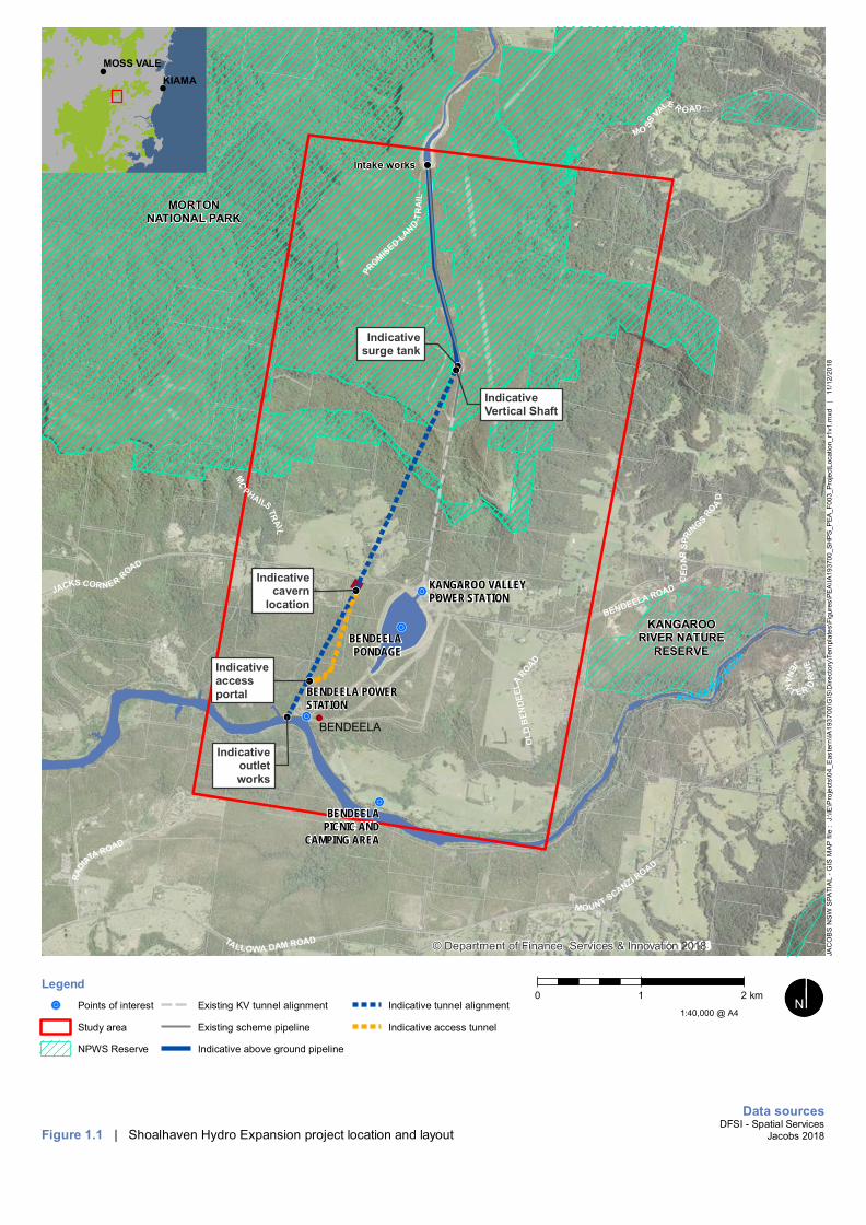
Origin Energy Eraring Pty Ltd (a subsidiary of Origin Energy Limited) (collectively, Origin) is the currentoperator of the Shoalhaven Pumped Hydro Energy Storage (PHES) Scheme (the existing scheme). Theexisting scheme is located in the NSW Southern Highlands, approximately 150km south east of Sydney(refer to Figure 1.1). The existing scheme was commissioned in 1977 and currently has a generatingcapacity of 240MW.
The existing scheme was designed and constructed as a dual-purpose system, having both pumped storagegeneration capacity and inter-region water supply ability to move water from the Shoalhaven catchment tothe Sydney drinking water catchment. The existing scheme was designed in the late 1960’s and Stage 1Phase 1 was constructed in the 1970’s including two generating / pumping units at Kangaroo Valley PowerStation and two generating units at the Bendeela Power Station.
The existing scheme was designed to allow for expansion and much of the required infrastructure neededfor duplicating the scheme is already in place.
Origin now proposes to almost double the electricity generation capacity of the existing scheme with theShoalhaven Hydro Expansion Project , which will provide approximately an additional 235MW of pumpedstorage generation capacity. Origin has completed a Pre Feasibility Study and is now undertaking aFeasibility Study for the Shoalhaven Hydro Expansion Project.
To confirm the feasibility of the Shoalhaven Hydro Expansion Project, geotechnical investigations arerequired to provide confidence that the below ground structures can be constructed and operated safely andcost effectively. The purpose of this report is to address Secretary’s Environmental AssessmentRequirements (SEARs) issued by New South Wales Department of Planning and Environment under section5.16 of the EP&A Act for these geotechnical investigations.
The geotechnical investigations are limited to the drilling of up to eight boreholes ranging in depth from 25 to650 metres below ground level and ancillary works to establish temporary access and works areas,geotechnical testing, decommissioning and rehabilitation. The target locations of the geotechnicalinvestigations are located at the proposed locations of key components of the Shoalhaven Hydro ExpansionProject or are aimed at facilitating improved understanding of identified higher risk ground conditions. In theevent that the project is deemed unfeasible, all geotechnical drilling locations would be decommissioned andrehabilitated to match the existing land use and habitat values of each location. Some bores would beconverted to monitoring bores.
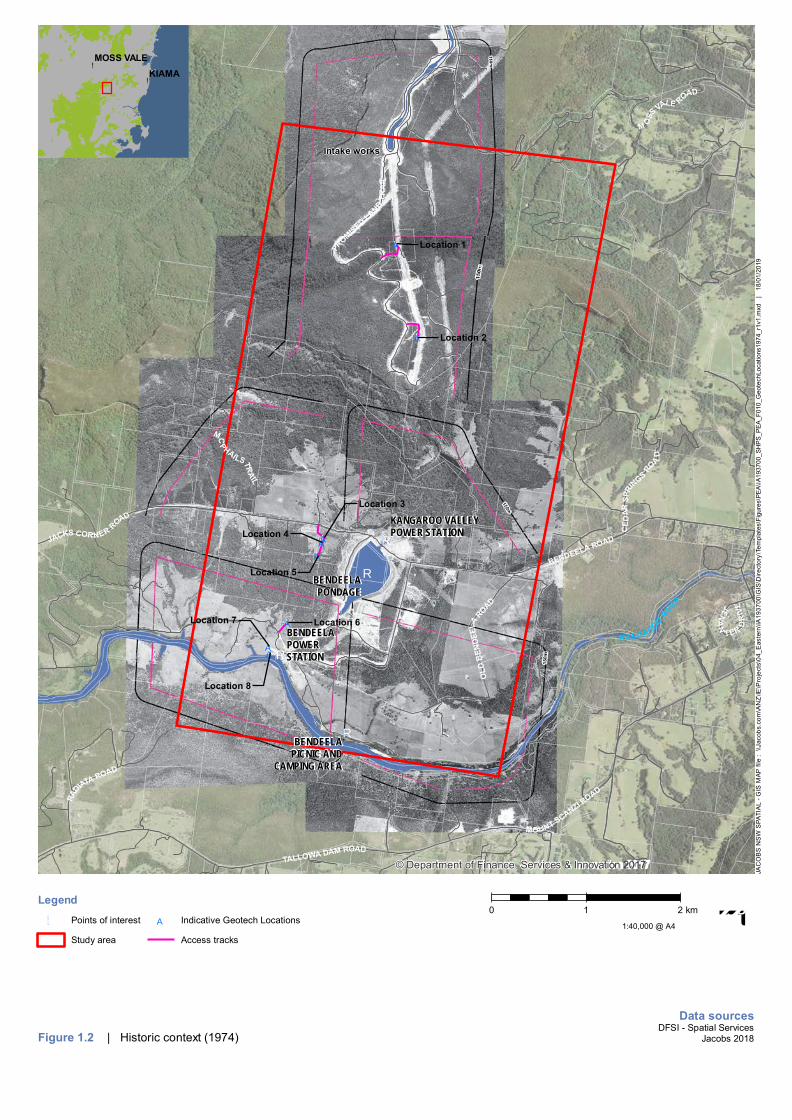
The geotechnical investigations are located in close proximity to the existing scheme and generally in areasof prior disturbance as illustrated in Figure 1.2. Locations 1, 2, 7 and 8 and their access tracks are positionedin currently cleared areas with evidence of prior ground disturbance. Locations 3, 4 and 5 are positionedwithin areas previously cleared for agricultural purposes that have revegetated naturally following theexclusion of agriculture. Location 6 is within an area that appears to be have been partially cleared andsubsequently naturally revegetated.
Clearing is only required for access and works areas at geotechnical investigation locations 3, 4, 5 and 6. Assuch, the focus of the Biodiversity Development Assessment Report is on these locations. Backgroundinformation review and site visits have covered locations 1, 2, 7 and 8 and it is confirmed that the findingsand conclusions of this report apply to the completion of the geotechnical investigations at all locations.
!!
!!
!!
!!
!!
!!!!
!!
!!R
!R
!R
!R
Intake works
Indicativecavern
location
Indicativesurge tank
Indicativeoutletworks
Indicativeaccessportal
IndicativeVertical Shaft
BENDEELA ROAD
OLD
BEN
DEEL
AROAD
JACKS CORNER ROAD
RADI
ATA ROAD
CED
ARSP
RINGS
RO
AD
MOUNT SCANZI ROAD
PROMISED LAND
TRA
I L
TALLOWA DAM ROAD
JENA
N
T ER DR
IVE
MC
PHAILSTRAIL
MO SS
VALER OAD
BENDEELA
KANGAROORIVER NATURE
RESERVE
MORTONNATIONAL PARK
BENDEELA POWERSTATION
KANGAROO VALLEYPOWER STATION
BENDEELAPONDAGE
BENDEELAPICNIC AND
CAMPING AREA
KANGAROO RIVER
© Department of Finance, Services & Innovation 2018
Legend
!R Points of interest
Study area
NPWS Reserve
Existing KV tunnel alignment
Existing scheme pipeline
Indicative above ground pipeline
Indicative tunnel alignment
Indicative access tunnel
Figure 1.1 | Shoalhaven Hydro Expansion project location and layout
!
!
KIAMAMOSS VALE
0 1 2 km
Data sourcesDFSI - Spatial Services
Jacobs 2018
1:40,000 @ A4 ¬«³³N
JAC
OB
S N
SW
SPA
TIA
L - G
IS M
AP fi
le :
J:\I
E\P
roje
cts\
04_E
aste
rn\IA
1937
00\G
IS\D
irect
ory\
Tem
plat
es\F
igur
es\P
EA\IA
1937
00_S
HPS
_PEA
_F00
3_Pr
ojec
tLoc
atio
n_r1
v1.m
xd
| 1
1/12
/201
8
!A
!A
!A!A
!A
!A
!A!A!R
!R
!R
!R
Intake works
Location 1
Location 2
Location 3
Location 4
Location 5
Location 6Location 7
Location 8
BENDEELA ROAD
OLD
BEN
DEEL
AROAD
JACKS CORNER ROAD
RADIATA ROAD
CED
ARSP
RINGS
RO
AD
MOUNT SCANZI ROAD
PROMISED LAND
TRA
I L
TALLOWA DAM ROAD
JENA
N
TER
DR
IVE
MCPHAILSTR
AIL
M OSS
VALE ROAD
BENDEELAPOWERSTATION
KANGAROO VALLEYPOWER STATION
BENDEELAPONDAGE
BENDEELAPICNIC AND
CAMPING AREA
KANGAROO RIVER
© Department of Finance, Services & Innovation 2017
Legend
!R Points of interest
Study area
!A Indicative Geotech Locations
Access tracks
Figure 1.2 | Historic context (1974)
!
!
KIAMAMOSS VALE
0 1 2 km
Data sourcesDFSI - Spatial Services
Jacobs 2018
1:40,000 @ A4 ¬«³³N
JAC
OB
S N
SW
SPA
TIA
L - G
IS M
AP fi
le :
\\Ja
cobs
.com
\AN
Z\IE
\Pro
ject
s\04
_Eas
tern
\IA19
3700
\GIS
\Dire
ctor
y\Te
mpl
ates
\Fig
ures
\PEA
\IA19
3700
_SH
PS_P
EA_F
010_
Geo
tech
Loca
tions
1974
_r1v
1.m
xd
| 1
8/01
/201
9

Biodiversity Development Assessment Report
4
1.2 Purpose of this report
This Biodiversity Development Assessment Report (BDAR) has been prepared in accordance with theBiodiversity Assessment Methodology 2017 (BAM), which is the central element of the NSW BiodiversityOffsets Scheme established under Part 6 of the Biodiversity Conservation Act 2016 (BC Act). The BDARidentifies the biodiversity values on the land proposed for geotechnical investigations, outlines the initiativesto avoid and minimise impacts to biodiversity as well as any offset requirements, where needed forunavoidable residual impacts. The report is structured as follows:
Chapter 1 introduces geotechnical investigations and their context and describes the assessmentmethodology;
Chapter 2 describes the proposed geotechnical investigations;
Chapter 3 summarises the relevant planning approval pathway and the associated environmentalassessment requirements for the geotechnical investigations;
Chapters 4 through to 8 document the methods and results of the assessment of the biodiversity values inthe study area by assessing the:
· Landscape features and site context in accordance with Chapter 4 of the BAM (results presented inChapter 5 of report);
· Presence of Threatened Ecological Communities (TECs), Plant Community Types (PCTs) and thecondition (vegetation integrity) of native vegetation in accordance with Chapter 5 of the BAM (resultspresented in Chapter 6 of report);
· Habitat suitability for threatened species on the geotechnical investigation locations in accordance withChapter 6 of the BAM (results are presented in Chapter 7 of report); and
· Matters of National Significance for threatened species and ecological communities listed under theEPBC Act presented in Chapter 8;
Chapter 9 and 10 identify potential impacts of the geotechnical investigations on biodiversity values andoutlines recommendations to avoid and minimise impacts;
Chapter 11 provides context to the size of the impact in relation to biodiversity offsets set out in the BAM,and hence applicability to the biodiversity offsets scheme; and
Chapter 12 provides a summary of the outcomes and conclusions of the assessment.
1.3 Assessment Methodology
The geotechnical investigations have been purposely designed to avoid and minimise disturbance to nativevegetation. This includes planning to work in existing cleared landscapes as much as possible. Whereclearing of native vegetation is required, each temporary work area and planning for access will be relativelysmall in area, hence the streamlined assessment module of the BAM (s.3.2 and Appendix A) is applicableand has been addressed. The components of the geotechnical investigations meet the area limits criteria forassessment as a small area, and are not located within the Biodiversity Values Map.
1.4 Sources of information
A background review of available online information was undertaken to identify the existing environment ofthe geotechnical investigation locations within a search area of 10 kilometres. The review focussed ondatabase searches, relevant ecological reports pertaining to the study area, property boundaries, andrelevant GIS layers. The review was used to prepare a list of threatened species, populations andcommunities as well as important habitat for migratory species with a likelihood of occurrence in the study
Biodiversity Development Assessment Report
5
area and locality. The searches were also undertaken to identify if any Areas of Outstanding BiodiversityValue were present.
The following database searches were performed:
· BioNet - the website for the Atlas of NSW Wildlife and OEH Threatened Species Profile Database;
· The federal Department of Environment and Energy Protected Matters Search Tool;
· The Biodiversity Assessment Method (BAM) calculator predicted species function;
· NSW Department of Primary Industries freshwater threatened species distribution maps (DPI, 2016);
· OEH BioNet Vegetation Classification System database;
· The Federal Bureau of Meteorology’s Atlas of Groundwater Dependent Ecosystems (GDE);
· Department of Environment and Energy directory of important wetlands;
· Atlas of Living Australia;
· Register of Declared areas of Outstanding Biodiversity Value; and
· Key fish habitat maps (DPI, 2007)
Spatial data used in the assessment included,
· Available regional vegetation mapping: Shoalhaven Biometric VIS 3900 v2 (OEH, 2013) and SoutheastNSW Native Vegetation Classification and Mapping – SCIVI (VIS_ID 2230) (Tozer et al. 2010).
· Mitchell Landscapes Version V3.1 (OEH, 2016);
· Interim Biogeographic Regionalisation of Australia (IBRA) Version 7 (DoEE, 2017); and
· Waterways stream orders (DPI, 2013)
1.5 Site context
The geotechnical investigations for the Shoalhaven Hydro Expansion Project would be undertaken in theNSW Southern Highlands, approximately 150 km south east of Sydney within the Shoalhaven LocalGovernment Area (Refer to Figure 1.1).
The geotechnical investigations are proposed in land owned by WaterNSW associated with the existingKangaroo Valley and Bendeela Power Stations and water transfer operations (Refer to Figure 1.1).WaterNSW land includes land either side of the existing surface pipeline and surge tank at the top of theplateau and land between Jacks Corner Road and Lake Yarrunga.
Access to geotechnical investigation locations on the plateau would be required via existing access tracksthrough the Morton National Park.
The major features of the area surrounding the geotechnical investigations include:
· The existing scheme;
· Morton National Park; and
· Rural landholdings.
1.5.1 The existing scheme
The existing Shoalhaven Scheme comprises the Fitzroy Falls reservoir, Fitzroy Falls canal, KangarooPipeline, Kangaroo Valley Power Station, Bendeela Pondage, Bendeela Pipeline, Bendeela Power Station,Tallowa Dam (Lake Yarrunga). The geotechnical investigations would require access through landassociated with the existing scheme but would not lead to any cumulative or ongoing impacts affecting thescheme or the environment.

Biodiversity Development Assessment Report
6
1.5.2 Morton National Park
The Morton and Budawang National Parks together comprise an area of over 190,000 hectares on theeastern escarpment of the Southern Tablelands. The park stretches from Bundanoon in the north tosoutheast of Braidwood and covers a diverse, rugged and scenically magnificent landscape. The MortonNational Park is managed in accordance with the Morton and Budawang National Parks Plan ofManagement (NSW NPWS, 2001). This document recognises the important landscape, geology,biodiversity, heritage and wilderness values of the Morton National Park. The document also recognisesexisting uses associated with water and electricity infrastructure.
The geotechnical investigations would require access via short sections of existing access tracksestablished as part of the construction of the existing Shoalhaven Scheme. No impacts to the MortonNational Park will result from the geotechnical investigations.
1.5.3 Surrounding landholdings
There are several communities and townships within the zone of influence of the Shoalhaven HydroExpansion Project. These include Barrengarry and Kangaroo Valley, Fitzroy Falls, Wildes Meadow, Avocaand Burrawang. The scale of the geotechnical investigations would not impact any of these populationcentres.
Landholdings surrounding the geotechnical investigation areas are rural in nature consisting of isolateddwellings. The Scots Collage Glengarry Campus is located approximately 500 metres to the west of thegeotechnical investigations.

Biodiversity Development Assessment Report
7
2. Project Description2.1 Investigation footprint
The geotechnical investigations includes eight cored borehole locations as described in Table 2-1 andillustrated on Figure 2.1. At each location the proposed activity will require the establishment of a temporaryworks area of less than 400 square metres. Accessing locations 3, 4, 5 and 6, would require theestablishment of temporary access tracks of under 500 metres in length and 2 metres in width with less than300 metres of this requiring clearing. In total, 0.21 hectares of clearing is anticipated.
Table 2-1: Preliminary borehole collar locations and depths
Borehole ID Location Inclination (°) ApproximateElevation RL (m)
HoleLength (m)
Location 1 Pipeline anchor block 90 548 25
Location 2 Vertical shaft 90 636 480 - 650
Location 3 Cavern Area 90 179 250
Location 4 Cavern Area 60 178 235
Location 5 Tailrace and crest of cliff 90 185 210
Location 6 Access tunnel portal + tailrace tunnel 90 69 70
Location 7 Tailrace Tunnel initial portal drive 90 73 55
Location 8 Tailrace channel cut 90 73 45
A brief description of each geotechnical investigation location is provided in Table 2-2, this table providesdetails of the existing conditions at the locations and the area expected to be cleared to complete theactivity. Specific information on the ecological values at each geotechnical investigation location is providedin Chapters 5 to 8.

!A
!A
!A!A
!A
!A
!A!A!R
!R
!R
!R
Intake works
Location 1
Location 2
Location 3
Location 4
Location 5
Location 6Location 7
Location 8
BENDEELA ROAD
OLD
BEN
DEEL
AROAD
JACKS CORNER ROAD
RADI
ATA ROAD
CED
ARSP
RINGS
RO
AD
MOUNT SCANZI ROAD
PROMISED LAND
TRA
I L
TALLOWA DAM ROAD
JENA
N
T ER DR
IVE
MC
PHAILSTRAIL
MO SS
VALER OAD
KANGAROORIVER NATURE
RESERVE
MORTONNATIONAL PARK
BENDEELAPOWERSTATION
KANGAROO VALLEYPOWER STATION
BENDEELAPONDAGE
BENDEELAPICNIC AND
CAMPING AREA
KANGAROO RIVER
© Department of Finance, Services & Innovation 2018
Legend
!R Points of interest
Study area
NPWS Reserve
!A Indicative Geotech Locations
Access tracks
Figure 2.1 | Geotechnical Investigation Locations
!
!
KIAMAMOSS VALE
0 1 2 km
Data sourcesDFSI - Spatial Services
Jacobs 2018
1:40,000 @ A4 ¬«³³N
JAC
OB
S N
SW
SPA
TIA
L - G
IS M
AP fi
le :
J:\I
E\P
roje
cts\
04_E
aste
rn\IA
1937
00\G
IS\D
irect
ory\
Tem
plat
es\F
igur
es\P
EA\IA
1937
00_S
HPS
_PEA
_F00
2_G
eote
chLo
catio
ns_r
1v1.
mxd
|
11/
12/2
018

Biodiversity Development Assessment Report
9
Table 2-2: Geotechnical investigation location photolog
Photo Location and description
Location 1Proposed anchor block location with works tobe limited to the existing area of disturbanceand concrete and access via existing accesstrack requiring no vegetation clearing.
Location 2Proposed vertical shaft location with works tobe limited to areas largely devoid of vegetationand within an area previously disturbed byconstruction of the original scheme.
Locations 3 and 4Ground above indicative power station cavernlocation require establishment of anapproximately 200 metre long and 2 metrewide temporary access track positioned toavoid disturbance of habitat features.Establishment of two works areas one foreach location (Location 3 above photo,Location 4 below photo), would requireestablishment of two temporary works areasof less than 20 metre by 20 metre dimensionavoiding habitat features.No ground disturbance is proposed other thanthe bore hole and access track.

Biodiversity Development Assessment Report
10
Photo Location and description
Location 5Location 5 is targeting the indicative tailraceand access tunnels and is aimed at providingimproved understanding of ancient landslideformation.Drilling location and works areas would be inan area previously cleared and naturallyrevegetated.Location 5 would require establishment of anapproximate 120 metre long and 2 metre widetemporary access track extending fromlocation 4 and positioned to avoid disturbanceof habitat features. The establishment of atemporary works area of less than 20 metre by20 metre dimension avoiding habitat featureswould also be required.No ground disturbance is proposed other thanthe bore hole and access track.
Location 6Indicative access tunnel portal location withgeotechnical investigations positioned to limitclearing to the extent possible and accessprovided by a 175 metre long, and 2 metrewide temporary access track and less than 20metre by 20 metre dimension temporary worksarea positioned to avoid disturbance of habitatfeatures.No ground disturbance is proposed other thanthe bore hole and access track.

Biodiversity Development Assessment Report
11
Photo Location and description
Location 7Indicative tailrace tunnel initial drive locationwith works to be limited to cleared andpreviously disturbed area within the Bendeelapower station site as shown. No new clearingis required for establishment of access orworks area.No ground disturbance is proposed other thanthe bore hole.
Location 8Targeting geotechnical properties of theindicative intake structure, with bore locationrelocated further east with the existing accessto the Bendeela power station forebay, out ofan adjacent area identified as moderatearchaeological potential.
2.2 Proposed activities
2.2.1 Drilling method and core sizes
General methods and requirements for drilling are expected to involve the following:
· Preparation of a bunded work area lined with a basal geotextile mat and then overlain by a heavy-dutyplastic impervious sheet. Bunded above ground mud pits/ tanks to prevent off site drilling fluiddischarges and other requirements. The mud pits will be fully impervious using both geotextile andplastic sheeting and additional barriers and redundancy to prevent any discharges;
· Boreholes may be advanced by augering in the upper soil profile, followed by wash boring to the rockhead which is expected to be a maximum of about 10 m below the surface. For drilling in soils,Standard Penetration Tests (SPT) may be performed in soils and undisturbed tube samples may becollected in cohesive or fine-grained soils; and
· Rock core drilling would commence from the top of bedrock and advanced to the target depth.
The drilling hole sizes are likely to range from 75 to 140 millimetres in diameter.
Biodiversity Development Assessment Report
12
2.2.2 Ancillary works
The following ancillary works would be undertaken at each geotechnical investigation location:
· Packer Testing - Down-hole water injection (Lugeon) rock mass permeability testing will be carriedwithin various boreholes using a gas-inflated packer wireline apparatus with a single packerconfiguration as the hole is advanced to the required depth for each test interval.
· In situ stress testing – A narrow 0.5m deep pilot hole drill will be drilled into the base of the borehole atvarious depths and a stress testing tool wedged into pilot hole. The pilot hole will then be over-coredand the stress testing tool will record deformations in the pilot hole resulting from relief of in situ stressduring the over coring process.
· Borehole Geophysics and Televiewer Surveys - All borehole walls will be imaged using acousticteleviewer (ATV) below the water table and optical televiewer (OTV) in dry sections of borehole.Geophysical surveys including full wave sonic, natural gamma, density and temperature profiles for thefull depth for each hole will also be undertaken. These surveys will be undertaken at the completion ofthe drilling and prior to installation of groundwater monitoring installations and or back-grouting of holes
· Groundwater Monitoring Installations - Groundwater monitoring installations will include a combinationof screened standpipe piezometers and grouted-in vibrating wire piezometers (VWP). The standpipepiezometers will allow for periodic groundwater quality sampling and level monitoring.
· Bore Completion Works - All holes that are not to be instrumented for long term groundwater monitoringwill be fully grouted at the completion of drilling work. The remaining holes that are to be completed forgroundwater monitoring will be fully grouted to the base depth of the monitoring well. The piezometerwill be finished with stick up of between 0.6m and 0.8m above ground level and finished with installationof a steel lockable monument.
2.2.3 Access
Access to bore holes 1 and 2 would be via the existing Promised Lands Trail off Moss Vale Road betweenFitzroy Falls and Barrengarry. The Promised Lands Trail runs through WaterNSW land and the MortonNational Park and was constructed to facilitate construction and operation of the existing scheme. No new,or modified access tracks are required for these locations.
Access to the remaining bore holes would be via Jacks Corner Road and Lower Bendeela Road off MossVale Road between Shoalhaven and Barrengarry. No upgrades to public roads would be required. Accessto boreholes 3 to 6 would require limited clearing of shrubs to ground level to establish a corridor to facilitatethe daily access of a drill rig, support vehicles and worker vehicles. No excavation of the ground surfacewould be undertaken and large, mature vegetation is expected to be avoidable due to historic clearing.
2.2.4 Duration and Timing
The deepest borehole drilling associated with the geotechnical investigations are anticipated to take up tothree months. Shallow bores would be completed over a period of a few weeks. Drilling is proposed to belimited to 10 hours per day, six days per week and during daylight hours.
2.2.5 Disturbance Requirements and Environmental Management
As identified in Table 2-2, minimal clearing for access and a work area is required at geotechnicalinvestigation locations 3, 4, 5 and 6. This involves providing access for a drill rig and clearing a temporaryworks area at the drill site. Clearing of vegetation would be done by hand removing shrubs, small trees andgroundcover vegetation to ground level, there will be no clearing of moderate and large sized trees anddeliberate disturbance of the soil layer would be avoided. This is expected to be a temporary disturbance ofmedium duration.
Works would be undertaken generally in accordance with Department of Planning and Environment (2017a)Exploration Code of Practice: Environmental Management and Department of Planning and Environment(2017b) Exploration Code of Practice: Rehabilitation.

Biodiversity Development Assessment Report
13
3. Legislative context3.1 NSW Planning Framework
The Environmental Planning and Assessment Act 1979 (EP&A Act) establishes the planning and approvalsprocess in NSW. The EP&A Act provides for the making of Environmental Planning Instruments (EPIs)including Local Environmental Plans (LEPs) and State Environmental Planning Policies (SEPPs), which setout requirements for particular localities and/or particular types of development. The applicable EPIs and theRegulations made under the EP&A Act determine the relevant planning approval pathway and theassociated environmental assessment requirements for proposed development activities.
3.1.1 Critical State significant infrastructure
Clause 16 of the State Environmental Planning Policy (State and Regional Development) 2011 (SRD SEPP)provides that:
Development specified in Schedule 5:
(a) may be carried out without development consent under Part 4 of the Act, and
(b) is declared to be State significant infrastructure for the purposes of the Act if it is not otherwise sodeclared, and
(c) is declared to be critical State significant infrastructure for the purposes of the Act.
Schedule 5 of the SRD SEPP lists:
(1) Development for the purposes of the Shoalhaven Hydro Expansion Project.
(2) The Shoalhaven Hydro Expansion Project includes the following:
a. exploratory geotechnical works for the design of the project,
b. A new underground pumped hydro station,
c. tunnels and underground and overground water pipelines,
d. surge tanks and intake and outlet structures,
e. the decommissioning of the underground pumped hydro power station and rehabilitation ofthe site.
(3) Development that is ancillary to other development in this clause (including the upgrading orconstruction of access roads, utilities infrastructure, construction accommodation, constructioncompounds).
(4) The development is to be carried out on land in Kangaroo Valley, Barrengarry and Fitzroy Falls.
(5) In this clause, development does not include the carrying out of surveys, sampling, environmentalinvestigations, archaeological excavations or other tests or investigations for the assessment of theproject.
Accordingly, the project is Critical SSI which requires approval under Division 5.2 of the EP&A Act and theNSW Minister for Planning is the determining authority.
Biodiversity Development Assessment Report
14
3.1.2 Application of other parts of EP&A Act
Under Division 5.2, Section 5.22 (Application of other provisions of Act):
“(1) Part 4 and Division 5.1 do not, except as provided by this Division, apply to or in respect of Statesignificant infrastructure (including the declaration of the infrastructure as State significantinfrastructure and any approval or other requirement under this Division for the infrastructure)”.
(2) Part 3 and environmental planning instruments do not apply to or in respect of State significantinfrastructure, except that:
(a) they apply to the declaration of infrastructure as State significant infrastructure or as criticalState significant infrastructure (and to the declaration of development that does not requireconsent), and
(b) they apply in so far as they relate to section 3.16, and for that purpose a reference in thatsection to enabling development to be carried out in accordance with an environmental planninginstrument or in accordance with a consent granted under this Act is to be construed as areference to enabling State significant infrastructure to be carried out in accordance with anapproval granted under this Division.
Accordingly, SEPPs and the LEPs do not affect the permissibility or assessment process for thegeotechnical investigations.
3.2 Biodiversity Conservation Act 2016
Part 7 of the Biodiversity Conservation Act 2016 (BC Act) requires that an application for State significantinfrastructure approval under Division 5.2 of the EP&A Act be accompanied by a "biodiversity developmentassessment report unless " the Secretary of the Department of Planning and the Chief Executive of theOffice of Environment and Heritage” determine that the proposed development is not likely to have anysignificant impact on biodiversity values".
The project SEARS, requested completion of a BDAR for the geotechnical investigations.
3.3 National Parks and Wildlife Act 1974The objects of the National Parks and Wildlife Act 1974 Act (NPW Act) are as follows:
(a) the conservation of nature, including, but not limited to, the conservation of:
(i) habitat, ecosystems and ecosystem processes, and
(ii) biological diversity at the community, species and genetic levels, and
(iii) landforms of significance, including geological features and processes, and
(iv) landscapes and natural features of significance including wilderness and wild rivers,
(b) the conservation of objects, places or features (including biological diversity) of cultural value withinthe landscape, including, but not limited to:
(i) places, objects and features of significance to Aboriginal people, and
(ii) places of social value to the people of New South Wales, and
(iii) places of historic, architectural or scientific significance,
(c) fostering public appreciation, understanding and enjoyment of nature and cultural heritage and theirconservation,
(d) providing for the management of land reserved under this Act in accordance with the managementprinciples applicable for each type of reservation.
The Morton National Park is reserved under the NPW Act and the use of existing roads within the reservedlands is required to access geotechnical investigation locations 1 and 2. The proposed geotechnical
Biodiversity Development Assessment Report
15
investigation locations 1 and 2 are approximately 40 metres from the Morton National Park. No works oractivities are proposed within the Morton National Park.
Part 12 of the NPW Act allows for the granting of leases, licences, easements and rights of way for activitieswithin reserved lands. Origin has agreed formal access arrangements for the use of existing access trackthrough the Morton National Park with National Parks and Wildlife services and no additional approvals areunderstood to be necessary.
3.4 Commonwealth referral requirements
The Environment Protection and Biodiversity Conservation Act 1999 (EPBC Act) is the primaryCommonwealth legislation relating to the environment. Under Part 3 of the EPBC Act, approval from theAustralian Minister for the Environment and Energy is required for a controlled action being an action that:
· Has, will have, or is likely to have a significant impact on a matter of national environmentalsignificance;
· Is undertaken on Commonwealth land and has, will have, or is likely to have a significant impact on theenvironment;
· Is undertaken outside Commonwealth land and has, will have or is likely to have a significant impact onthe environment of Commonwealth land; or
· Is undertaken by the Commonwealth and has, will have or is likely to have a significant impact on theenvironment.
A significant impact under the EPBC Act is an impact which is important, notable, or of consequence, havingregard to its context or intensity. Whether or not an action is likely to have a significant impact depends uponthe sensitivity, value, and quality of the environment which is impacted, and upon the intensity, duration,magnitude and geographic extent of the impacts. Matters of national environmental significance (MNES)include:
· World heritage properties;
· National heritage places;
· Wetlands of international importance (often called 'Ramsar' wetlands after the international treaty underwhich such wetlands are listed);
· Nationally threatened species and ecological communities;
· Migratory species;
· Commonwealth marine areas;
· The Great Barrier Reef Marine Park;
· Nuclear actions (including uranium mining); and
· A water resource, in relation to coal seam gas development and large coal mining development.
It is generally the responsibility of the proponent (or the land owner if owned by the Commonwealth) of aproposed action to determine whether the Project, or action, has the potential to impact upon a MNES andconstitute the need for a referral to the Commonwealth for determination. An action that is referred forconsideration by the Australian Minister for the Environment and Energy cannot be undertaken until theoutcome of the referral process is completed - either through the decision of the Minister that the action isnot a controlled action or that the assessment and approval process has been completed.
Impacts to MNES are considered in Chapter 8 and it is concluded that a significant impact is not likely andas such a referral is not required.

Biodiversity Development Assessment Report
16
4. Methodology4.1 Small area assessment module
The BAM module for assessing small areas has been applied for this BDAR on the basis that thecumulative area to be disturbed by the geotechnical investigations is below the maximum clearingarea threshold set out in the BAM. In this regard the minimum lot size associated with the study areais 1 ha and the proposed activity would involve clearing/disturbance to less than 1ha of nativevegetation (i.e. less than 0.25 ha).
The assessment approach adopted included a site survey and collection of plot-based survey data toidentify Plant Community Types (PCTs), vegetation zones and vegetation integrity. Survey data wasused to determine the habitat suitability for threatened species.
The streamlined assessment module for small area development component of the BAM CreditCalculator only accepts assessment of one PCT, therefore the assessor has used the standardassessment module for this assessment.
4.2 Personnel
This BDAR has been prepared by an accredited assessor in accordance with Section 6.10 of the BCAct; and qualified and experienced ecologists. The fieldwork undertaken during the preparation of thisBDAR was led by Jonathan Carr (BAAS18009) and Lauren Ascah.
4.3 Background research
A background review of available online information was undertaken to identify the existingenvironment of the geotechnical investigation locations within a search area of 10 kilometres. Thereview focussed on database searches, relevant ecological reports pertaining to the study area,property boundaries, and relevant GIS layers. The review was used to prepare a list of threatenedspecies, populations and communities as well as important habitat for migratory species with alikelihood of occurrence in the study area and locality. The searches were also undertaken to identifyif any Areas of Outstanding Biodiversity Value were present.
The following database searches were performed:
· BioNet - the website for the Atlas of NSW Wildlife and OEH Threatened Species ProfileDatabase;
· The federal Department of Environment and Energy Protected Matters Search Tool;
· The Biodiversity Assessment Method (BAM) calculator predicted species function;
· OEH BioNet Vegetation Classification System database;
· The Federal Bureau of Meteorology’s Atlas of Groundwater Dependent Ecosystems (GDE);
· Atlas of Living Australia; and
· Register of Declared areas of Outstanding Biodiversity Value.
Spatial data used in the assessment included:
· Available regional vegetation mapping: Shoalhaven Biometric VIS 3900 v2 (OEH, 2013) andSoutheast NSW Native Vegetation Classification and Mapping – SCIVI (VIS_ID 2230) (Tozer etal. 2010).
· Mitchell Landscapes Version V3.1 (OEH 2016);
Biodiversity Development Assessment Report
17
· Interim Biogeographic Regionalisation of Australia (IBRA) Version 7 (DoEE 2017); and
· Waterways stream orders (DPI, 2013).
Likelihood of occurrence for each species identified in the desktop search was assigned based onknowledge of the species’ preferred habitats and known distributions, confirmed against the assumedhabitat in the study area. Verified sightings of threatened species were also used to determine aspecies’ presence in the area.
The likelihood of occurrence table (Appendix A) summarises all potential threatened species whichmay occur at the site based on the above searches. The table indicates which search the species waslisted in, as well as the species known range/habitat, and the deemed likelihood of occurrence at thesite.
4.4 Field survey timing
Each geotechnical investigation location and temporary access track was identified in the field andtraversed on foot to search for threatened species and complete vegetation integrity plots. The fieldsurveys were undertaken over 2 days on 10 and 11 January 2019.
4.5 Stratification of native vegetation
A streamlined assessment allows the use of existing information such as VIS Flora Survey Module inBioNet and existing vegetation maps and ecological reports. No local floristic data in surveys or sitesin the VIS Flora Survey were found.
The preliminary extent of each PCT within the proposal area was firstly reviewed using regionalvegetation mapping spatial layers in Shoalhaven Biometric VIS 3900 v2 (OEH, 2013) and SCIVIVIS_ID 2230. The regional mapping was used to develop a survey design for stratifying vegetationzones and sampling the required number of plots based on the existing broad condition state ofvegetation types. Prior to the field survey, proposed plots/mid-lines were randomly marked on mapwithin each area of mapped vegetation or direct geotechnical locations to provide a representativeassessment of the vegetation. At each point, a random number was selected between 1-360 togenerate a compass bearing for the direction of plots/mid-lines. Plots were positioned to provide awide spatial coverage of the proposal area and where possible, avoided locations on ecotones, tracks(their edges) and/or disturbed areas distinguishably different to the target vegetation zones.
The preliminary vegetation mapping was examined and where possible vegetation within the proposalarea was identified according to the Plant Community Types (PCTs) classification as described in theNSW Vegetation Information System (VIS) Classification database. In addition to the descriptions ofPCTs provided in the VIS database, broad scale vegetation mapping of the area including the Nativevegetation of southeast NSW: a revised classification and map for the coast and eastern tablelands(Tozer et al. 2010) was used to inform the identification of PCTs. Many PCTs could not be confidentlyidentified before further detailed floristic data and vegetation structure data was collected on site. Inthese cases, PCTs were assigned upon examination of the field data. The preliminary vegetationmapping was altered in some areas, but generally kept within the same vegetation class.
4.6 Assessment of vegetation zones
The field surveys were designed to assess the environmental variation within the site. The conditionof PCTs was assessed in accordance with Chapter 5 of the BAM and vegetation zones assigned bycomparing the dominant species, the general description of location, soil type and other attributes asdescribed in the VIS classification database. Each PCT was divided into vegetation zones (an area of

Biodiversity Development Assessment Report
18
native vegetation in the proposed area that is the same PCT and has a similar broad condition state).The PCTs identified within the proposal area are outlined in detail in Chapter 6.
Four vegetation zones were identified (labelled 1 to 4) (see Table 4.1) based on the PCT and broadcondition state. Vegetation was assigned to two broad condition classes: Moderate to Good(Regrowth) and Low condition regrowth.
The vegetation zones assigned as Moderate to Low and included regrowth condition class mostlycomprised of tree and shrub regrowth or regeneration with evidence of old clearing activities greaterthan 40 years old.
Rapid data points (RDPs) and walked tracks were mapped in the field using a GPS tablet (TrimbleYuma and Garmin 64S). RDPs were used to map and identify PCTs/vegetation zone boundaries(ecotones) and broad condition state by assessing the presence of dominant plant species.
4.7 Plot survey
A plot-based full floristic survey was undertaken according to the BAM using a series of 20 x 20 metreplots (or 400 m2 equivalent area) nested inside a 20 x 50 metre plot (or equivalent 1,000 m2
equivalent area). The number of plots/mid-lines required per vegetation zone area were completedaccording to the BAM (see Table 4-1). The location of each plots/mid-lines undertaken during thesurvey is illustrated in Figure 6.1. Plots/mid-lines were established to provide a representativeassessment of the vegetation integrity of the vegetation zone, accounting for the level of variation inthe broad condition state of the vegetation zone.
Table 4-1: Number of plots/mid-lines completed per vegetation zone
VegetationZone
Plant Community Type name PCTID
Vegetationzone(condition)
Vegetationzone area(ha)
Minimumnumber ofplots/mid-lines required
Number ofplots/mid-linescompleted
1 Turpentine - Red Bloodwood -Sydney Peppermint shrubby openforest on the foothills, southernSydney Basin Bioregion andnorthern South East CornerBioregion
1283 Moderate toGood(regrowth)
0.16 1 2
2 Sydney Blue Gum x Bangalay -Lilly Pilly moist forest in gullies andon sheltered slopes, southernSydney Basin Bioregion
1245 Moderate toGood(regrowth)
0.05 1 1
4 River Peppermint - Rough-barkedApple - River Oak herb/grassriparian forest of coastal lowlands,southern Sydney Basin Bioregionand South East Corner Bioregion
1108 Low(regrowth)
0.09 1 2
Total 3 5
4.8 Assessing vegetation integrityThe minimum number of plots/mid-lines were completed for each vegetation zone and recordedcomposition, structure and function attributes to assess vegetation integrity (site condition). Theseattributes were ranked against benchmark data for the relevant PCT and a vegetation integrity score
Biodiversity Development Assessment Report
19
for each vegetation zone was determined in accordance with subsection 5.3 of the BAM. Thefollowing vegetation integrity attributes collected are described below.
Composition
Composition was assessed using the following information in each 400m2 plot:
· Total number of native plant species (richness) was observed and recorded;
· Full species names (to the lowest taxonomic order) of above ground vascular plant species wererecorded where sufficient plant material was available for identification using nomenclatureconsistent with PlantNet NSW;
· At least the three dominant native plants identified to species level;
· Stratum and layer - in which each species occurs;
· Growth form - for each recorded species;
· Exotic and High Threat Exotic (HTE) plant species were also recorded;
· The composition of each allocated growth form was assessed by counting the number ofdifferent native plant species within each growth form group (i.e. tree, shrub, grass and grasslike, forb, fern and other); and
· Abundance rating – A relative measure of the number of individuals or shoots of a species withinthe plot. The following intervals were used; numbers above about 20 are estimates only:1,2,3,4,5,6,7,8,9,10,20,50,100,500,1000. Numbers between 20 and 1000 individuals wereestimated only as it is not possible to accurately count large numbers of some species in the plot.
Structure
Structure was assessed using the following information in each 400m2 plot:
· Foliage cover was measured or estimated as a percentage for each growth form group from allliving plant material of all individual plant species rooted or overhanging in the plot;
· Cover was recorded in decimals if less than 1% or whole numbers up to 5% or to the nearest 5%where greater than 5% cover;
· Cover - a measure or estimate of the appropriate cover measure for each recorded species;recorded from 1–5 per cent and then to the nearest 5 per cent. If the cover of a species is lessthan 1 per cent and the species is considered important, then the estimated cover should beentered (e.g. 0.4);
· Structure was calculated as the sum of all the individual foliage cover estimates of all native plantspecies recorded within each growth form group within each plot; and
· Each non-native (exotic) plant species foliage cover estimate and either Exotic and High ThreatExotic (HTE).
Function
Function was assessed using the following information in each 1,000 m2 plot:
· Number of large trees - count of all living stems with a DBH equal to or greater than the largetree benchmark DBH size for that PCT or vegetation class. For the PCTs on this site, the largetree benchmark DBH size is greater than 50cm;
· Tree regeneration – recorded presence or absence of living trees with stems <5cm DBH;
· Stem size class - recorded presence or absence of living tree stems that fall betweenregenerating stems (<5cm DBH) and the large tree benchmark DBH size(s) (i.e. <5, 5–9, 10–19,20–29, 30–49, 50–79, and 80+ cm DBH) and include all species in the tree growth form group;

Biodiversity Development Assessment Report
20
· Total length of fallen logs - total length in metres of all woody material greater than 10cm indiameter that is dead and entirely or in part on the ground in each plot;
· Litter cover - percentage litter cover was measured in five 1 m x 1 m sub-plots located fivemetres out from 50 metre mid-line marked at 5m, 15m, 25m, 35m and 45m. Litter was taken asplant material detached from a plant including leaves, seeds, twigs, branchlets and branches withdiameter of <10 cm. Litter not in contact with the ground is not recorded. The estimated littercover from each five sub-plots were averaged to generate the average percentage litter cover forthe entire plot;
· High threat exotic vegetation cover – was collected from the structure data assessment in 400 m2
plot, but entered into the function data section in the BAM calculator; and
· Hollow bearing trees – number of hollow-bearing trees (living or dead) were counted with at leastone hollow with an opening width greater than or equal to five centimetres and the hollow at leastone metre above the ground. Hollows in the shrub growth form group were also counted if metrequirements.
4.9 Limitations
The vegetation field survey was able to provide good spatial coverage and survey effort of each PCTpresent on the site, meeting the requirements of the BAM. The vegetation within the study area hasbeen assigned to a PCT as listed in the VIS database based on the observed species composition,vegetation structure, landscape position, and underlying geology and soils. The mapping provided inthis report is supported by on ground observations and quantitative data. Plant communities arenaturally variable and the boundaries between different PCTs overlap considerably. Often theboundary between PCTs is indistinct and the boundaries between PCTs usually involve ecotones,with a gradual transition from one community to another. However, a choice must be made to mapand assign a PCT to a particular area of the site. As mapping necessitates that a hard boundary isdrawn to separate PCTs, boundaries of PCTs and vegetation zones have been mapped as best aspossible based on observations made during the field survey and aerial photography. It is likely thatthe boundaries of PCTs and vegetation zones will change with time. The descriptions of the PCTs inthe VIS database represented in the proposal area mostly have a classification confidence level ofVery Low and in many cases, the PCTs have a highly variable mixed canopy, shrub layer and groundcover species complement. The vegetation has been assigned to a PCT that was considered themost likely PCT based on the published descriptions of PCTs available in the VIS database based onthe field data collected from site.
The list of species recorded in each PCT during this study should not be seen to be fullycomprehensive, but rather an indication of the species apparent at the time of the survey. The surveywas undertaken in summer. A period of several seasons or years is needed to identify all the speciespresent in an area, especially as some species are only apparent at certain times of the year (e.g.orchids, annual herbs and grasses). Some species require specific prevailing weather conditions (e.g.recent rainfall) for optimum detection.
The conclusions of this report are based upon available data and the field surveys and are thereforeindicative of the environmental condition of the study area at the time of the survey. It should berecognised that conditions, including the presence of threatened species, can change with time.

Biodiversity Development Assessment Report
21
5. Landscape contextThe majority of the footprint of the geotechnical investigation locations have been previously disturbedduring the construction of the existing scheme. However, a review of satellite imagery indicatesconsiderable regeneration and the surrounding locality is known to retain considerable biodiversityvalues including a number of threatened or endangered species and communities listed under Stateand Commonwealth legislation. Landscape features and site context are illustrated in Figure 5.1.
5.1 IBRA Bioregions and sub-regions
The geotechnical investigations are located in the Sydney Basin bioregion, on the border between twoSub-regions; Ettrema and Illawarra, as defined by the Interim Biogeographic Regionalisation forAustralia (IBRA 7) (SA Department of Environment Water and Natural Resources, 2015).
5.2 BioNet NSW Landscapes (Mitchell landscapes)
The geotechnical investigation locations requiring clearing are located within the Kangaroo ValleyMitchell landscape, while locations 1 and 2 are located within the bordering Fitzroy Falls EscarpmentMitchell landscape, as mapped by the NSW National Parks and Wildlife Service (2002) and describedby the NSW Department of Environment and Climate Change (2008).
The Kangaroo Valley landscape, located in the Ettrema and Illawarra IBRA sub-regions contains anenclosed, narrow, western facing valley surrounded by sandstone escarpment features. Soils on theslopes are loamy sand matrix in a sandstone rubble beneath cliff lines, then yellow texture-contrastprofiles grading to deep loam on the valley floors. The general elevation of the valley floor is 80 to100 m, with local relief 180 m. Vegetation below the escarpment is broadly characterised by tallforests of yellow stringybark (Eucalyptus muelleriana), Sydney peppermint (Eucalyptus piperita),silvertop ash (Eucalyptus sieberi), turpentine (Syncarpia glomulifera), two-veined hickory (Acaciabinervata), narrow-leaved geebung (Persoonia linerais), and sandfly zieria (Zieria smithii). Openforests on the foothills of the escarpment broadly contain forest oak (Allocasuarina torulosa), forestred gum (Eucalyptus tereticornis), rough-barked apple (Angophora floribunda), southern mahogany(Eucalyptus botryoides), river peppermint (Eucalyptus elata), and Breynia sp. The percentage ofcleared land in this landscape is 42%.
5.3 Rivers, streams and estuariesGeotechnical investigation location 1 is at the foot of a valley in an area that was filled associated withthe construction of the anchor block for the existing scheme surface pipeline. This valley is mappedas containing a first order creek up stream of Trimbles Creek which is mapped as Key Fish Habitatapproximately 1.3 kilometres downstream of geotechnical investigation location 1 (refer to Figure 5.2).
Geotechnical investigation locations 3, 4, and 5 and 6, where clearing is required, are within thecatchment of Kings Creek which is mapped as Key Fish Habitat. These locations are over 100 metresfrom the creek and no direct or indirect impacts to Kings Creek are likely.
Geotechnical investigation locations 7 is adjacent to, and location 8 is within, the mapped area of KeyFish Habitat for Lake Yarrunga. No clearing or impact to key fish habitat is likely due to the nature ofthe works proposed and control measures to be employed.
5.4 WetlandsNearby Bendeela Pondage and Lake Yarrunga are both classified as wetlands, however they do notintrude onto the area impacted by the geotechnical investigations.
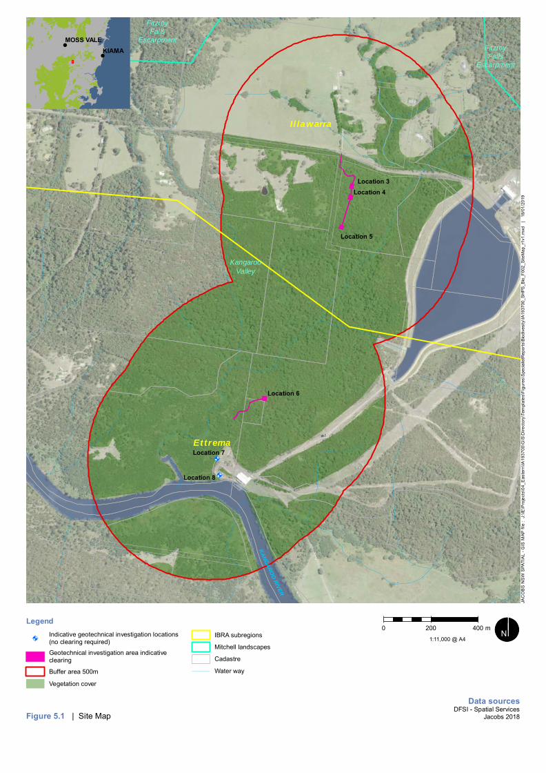
!A
!A
KANGAROO RIVER
I l lawarra
Ettrema
FitzroyFalls
Escarpment
FitzroyFalls
Escarpment
KangarooValley
Location 3Location 4
Location 5
Location 6
Location 7
Location 8
Legend
!AIndicative geotechnical investigation locations(no clearing required)
Geotechnical investigation area indicativeclearing
Buffer area 500m
Vegetation cover
IBRA subregions
Mitchell landscapes
Cadastre
Water way
Figure 5.1 | Site Map
!
!
KIAMAMOSS VALE
0 200 400 m
Data sourcesDFSI - Spatial Services
Jacobs 2018
1:11,000 @ A4 ¬«³³N
JAC
OB
S N
SW
SPA
TIA
L - G
IS M
AP fi
le :
J:\I
E\P
roje
cts\
04_E
aste
rn\IA
1937
00\G
IS\D
irect
ory\
Tem
plat
es\F
igur
es\S
peci
alis
tRep
orts
\Bio
dive
sity
\IA19
3700
_SH
PS_B
io_F
002_
Site
Map
_r1v
1.m
xd
| 1
8/01
/201
9

!A
!A
!A!A
!A
!A
!A!A!R
!R
!R
!R
Intake works
Location 1
Location 2
Location 3
Location 4
Location 5
Location 6Location 7
Location 8
BENDEELA ROAD
OL DB
ENDE
ELA
RO
AD
JACKS CORNER ROAD
RADIATA ROAD
CED
ARSP
RINGS
RO
AD
MOUNT SCANZI ROAD
PROMISED LAND
TRA
I L
TALLOWA DAM ROAD
JENA
N
TER
DR
IVE
MCPHAILSTR
AIL
M O SS
VALE R OAD
KANGAROORIVER NATURE
RESERVE
MORTONNATIONAL PARK
BENDEELAPOWERSTATION
KANGAROO VALLEYPOWER STATION
BENDEELAPONDAGE
BENDEELAPICNIC AND
CAMPING AREA
KANGAROO RIVER
Legend
!R Points of interest
Study area
NPWS Reserve
!A Indicative Geotech Locations
Access tracks
Key fish habitat (NSW DPI2015)
Figure 5.2 | Key Fish Habitat
!
!
KIAMAMOSS VALE
0 1 2 km
Data sourcesDFSI - Spatial Services
Jacobs 2018
1:40,000 @ A4 ¬«³³N
JAC
OB
S N
SW
SPA
TIA
L - G
IS M
AP fi
le :
J:\I
E\P
roje
cts\
04_E
aste
rn\IA
1937
00\G
IS\D
irect
ory\
Tem
plat
es\F
igur
es\P
EA\IA
1937
00_S
HPS
_PEA
_F00
2_G
eote
chLo
catio
ns_r
1v1.
mxd
|
18/
01/2
019

Biodiversity Development Assessment Report
24
5.5 Connectivity
The assessed area is well connected to the forests to the West of locations 3 to 8 with the areas eastof Bendeela Pondage largely cleared. Geotechnical investigation locations 1 and 2 are located in anexisting cleared areas within a narrow strip of WaterNSW land running through the Morton NationalPark and in areas of good connectivity.
5.6 Areas of geological significance and soil hazard features
Areas of geological significance generally include karst, caves, crevices and cliffs. Some rocky habitatpresent near the geotechnical investigation locations contained small crevices. The escarpment to thesouth of location 1 and 2 contain cliffs and crevices.
Soil hazard features such as dryland salinity, acidification, structural breakdown, sodicity andcontamination were not noted during the field surveys. There were no apparent plant growth problemsnoted due to soil health. Soils at the site were generally sandy-loam, and drainage was good in allassessed areas. The acid sulfate soil risk has not been mapped for the study area. Based onsurrounding topography, it is assumed to be low risk.
5.7 Areas of outstanding biodiversity value
The study area does not contain any areas of outstanding biodiversity value listed on the register ofdeclared areas of outstanding biodiversity value.
5.8 Native vegetation extent
To assess percent current extent of native vegetation in the buffer area around locations requiringclearing, a buffer of 500 metres was placed around the centre boundaries of each linear proposalarea. Native over storey vegetation was digitised off an aerial photograph to determine the extent ofnative vegetation cover within the 500 metre landscape buffer (see Figure 5.1). Obviously clearedareas were excluded from the mapping. However, the calculations are however subject to a degree oferror as the mapping is an abstraction of reality. The extent of native vegetation cover within the 500metre landscape buffer was then calculated in a GIS.
There are approximately 161 hectares of native vegetation within the 500 metre landscape buffer. Thelandscape buffer is 224 hectares in size. This results in a percent native vegetation cover of 72%.Therefore, the cover class for the development site is >70%.
5.9 Patch sizes
The patch sizes for each vegetation zone in the proposed stewardship site has been determined inaccordance with Section 5.3.2 of the BAM. The BAM defines patch size as an area of nativevegetation (intact) that:
a) occurs on the development site or biodiversity stewardship site; and
b) includes native vegetation that has a gap of less than 100m from the next area of moderate togood condition native vegetation (or ≤30m for non-woody ecosystems).
Patch size may extend onto adjoining land that is not part of the development site. Intact vegetationmust include all structural layers (strata) characteristic of the PCT. The site comprises of all woodyecosystems with a very high connectivity with large areas of intact contiguous native vegetation.Patch size area was assigned to each vegetation zone as a class, being <5ha, 5–24ha, 25–100ha or≥100ha. The results of patch size assessment are shown in Section 6.2 of this report.

Biodiversity Development Assessment Report
25
6. Native Vegetation6.1 Plant Community Types and vegetation zones
A description of each Plant Community Type (PCT) in the area surrounding locations requiringclearing is provided in this section. This BDAR describes PCTs in terms of their floristic composition,geological substrate, landscape position and relevant regional vegetation classification according tothe VIS classification database and plot data. Table 6.1 summarises each PCT including thecorresponding threatened ecological community (if applicable). The distribution of PCTs within thesurrounding areas requiring clearing is outlined in Figure 6.1.
Vegetation zones are defined under the BAM as a relatively homogenous area of native vegetationthat is the same PCT and broad condition state. The vegetation was first split into PCTs then thebroad condition states of the PCTs were investigated on-ground to determine the number ofvegetation zones within the proposal area.
Table 6.1 : Summary of PCTS and TECs located in the proposal area
Vegetationzones
Plant Community Type Vegetationformation
Percentcleared inmajorcatchmentarea
CorrespondingThreatened EcologicalCommunity (TEC)
Area(ha)
Patchsize
1 Turpentine - RedBloodwood - SydneyPeppermint shrubby openforest on the foothills,southern Sydney BasinBioregion and northernSouth East CornerBioregion (PCT 1283)
WetSclerophyllForests(Grassy sub-formation)
15% N/A 0.15 >100
2 Sydney Blue Gum xBangalay - Lilly Pilly moistforest in gullies and onsheltered slopes,southern Sydney BasinBioregion (PCT 1245)
WetSclerophyllForests(Shrubby sub-formation)
43% N/A 0.05 >100
3 River Peppermint -Rough-barked Apple -River Oak herb/grassriparian forest of coastallowlands, southernSydney Basin Bioregionand South East CornerBioregion (PCT 1108)
ForestedWetlands
50% River-Flat Eucalypt Foreston Coastal Floodplains ofthe New South WalesNorth Coast, Sydney Basinand South East CornerBioregions (BC Act)
0.06 >100
6.1.1 Turpentine - Red Bloodwood - Sydney Peppermint shrubby open forest on thefoothills, southern Sydney Basin Bioregion and northern South East CornerBioregion (PCT 1283)
Vegetation formation: Wet Sclerophyll Forests (Grassy sub-formation)
Vegetation class: Southern Lowland Wet Sclerophyll forests

Biodiversity Development Assessment Report
26
Threatened Ecological Community: N/A
Vegetation zones / survey effort / extent on site:
· Zone 1 (Moderate - Regrowth): 2 plots (1 and 3) / 0.16 ha
Turpentine - Red Bloodwood - Sydney Peppermint shrubby open forest on the foothills, southernSydney Basin Bioregion and northern South East Corner Bioregion is a tall open forest with a denseshrub understorey occurring on sheltered slopes with loamy soil.
On site, PCT 1283 was dominated by a mix of regrowth tree species including Syncarpia glomuliferasubsp. glomulifera, Angophora floribunda, Eucalyptus eugenioides, and occasional Eucalyptus sciassubsp. callimastha, Eucalyptus saligna x botroyoides and Corymbia gummifera in the canopy. Theshrub layer was very dense with regrowth dominated by Kunzea ambiguea and Hakea salicifolia andhad a high richness of other shrubs (n=19) Leptospermum trinerivum, Acacia irrorata, Callistemoncitrinus and Melaleuca linariifolia.
Diagnostic shrubs includes Banksia spinulosa subsp. spinulosa and Persoonia linearis. Thegroundcover had a high cover of leaf litter with a range of perennial herbs as well as some grasses,climbers and ferns. Species included Dianella caerulea, Entolasia stricta and Pteridium esculentum.
On the lower foothills closer to the Kangaroo Valley River floodplain there was a richness of shrubsincluding Breynia oblongifolia, Pittosporum undulatum, Leucopogon juniperinus, Persoonia linearis,Allocasuarina littoralis, Bursaria spinosa and Daviesia ulicifolia. The groundcover had a high cover ofleaf litter with a range of grasses including Microlaena stipoides, Panicum simile, Paspalidium distans,Eragrostis brownii, Entolasia stricta and Oplismenus aemulus. There were also a range of herbs,rushes, and Glycine spp. climbers.

Biodiversity Development Assessment Report
27
Photograph 1: Plot 1 of Vegetation Zone 1 (Moderate - Regrowth) with Turpentine - Red Bloodwood - SydneyPeppermint shrubby open forest on the foothills, southern Sydney Basin Bioregion and northern South East CornerBioregion (PCT 1283)
This vegetation is considered most likely to be representative of PCT 1283 for the following reasons:
· Dominance of Syncarpia glomulifera with a mix of other diagnostic tree species, includingoccasional Eucalyptus scias subsp. callimastha, and Corymbia gummifera; as well as Eucalyptuspipertia on the lower foothills;
· The middle stratum was generally dense and rich with sclerophyllous shrub species includingcharacteristic species Acacia obtusifolia, Persoonia linearis, Banksia spinulosa, Elaeocarpusreticulatus;
· The ground stratum is characterised Dianella caerulea; Entolasia stricta; Pteridium esculentumand a suite of ground stratum species common to other PCTs on the site; and
· Semi-sheltered west facing slope with sandy loam soils on lowlands/foothills below theescarpment, transitioning into Kangaroo Valley River floodplain (PCT1108).
Given the past disturbance and high level of tree and shrub regrowth on the site, it was difficult toascertain a definitive PCT. The broader patch was also dominated by Eucalyptus eugenioides andAngophora floribunda typical of Forest Red Gum - Thin-leaved Stringybark grassy woodland oncoastal lowlands, southern Sydney Basin Bioregion (PCT 838), however lacked any regrowth ofEucalyptus tereticornis and continuous grassy cover, perhaps a result of past selective logging. Thereis potential for PCT 838 listed as a Threatened Ecological Community Illawarra Lowlands GrassyWoodland in the Sydney Basin Bioregion (BC Act) in the broader region. As the study area hascharacteristic tree species present and occurrence of wet sclerophyllous and mesic rainforest shrubsand low cover of grasses, the community is best suited within the Wet Sclerophyll Forests (Grassysub-formation) Vegetation Formation.
The site also intergrades with a mix of Eucalyptus saligna x botroyoides likely transitioning into PCT1245 especially down slope to the west and south where a dominance of rainforest shrubs are moreprevalent. Regrowth comprised of high densities of natural tree and shrub regeneration with a lowabundance of weeds. High Threat Weed Ligustrum sinense was observed in PCT with a low cover ofabundance.
6.1.2 Sydney Blue Gum x Bangalay - Lilly Pilly moist forest in gullies and on shelteredslopes, southern Sydney Basin Bioregion (PCT 1245)
Vegetation formation: Wet Sclerophyll Forests (Shrubby sub-formation)
Vegetation class: North Coast Wet Sclerophyll Forests
Threatened Ecological Community: N/A
Vegetation zones / survey effort / extent on site:
· Zone 2 (Moderate - Regrowth): 1 plot (2) / 0.04 ha
Sydney Blue Gum x Bangalay - Lilly Pilly moist forest in gullies and on sheltered slopes, southernSydney Basin Bioregion is a very tall open forest which can have multiple layers of rainforest trees,palms and shrubs. Grows on deep chocolate clay soils on escarpment benches, alluvial flats andprotected gullies.
On site, PCT 1245 was dominated by a mix of regrowth tree species including Eucalyptus saligna,Eucalyptus botroyoides and Eucalyptus saligna x botroyoides and Syncarpia glomulifera subsp.glomulifera, with occasional Angophora floribunda and Eucalyptus eugenioides. Parts of themidstorey was dense with Kunzea ambigua as well as dominated by Acacia mearnsii, Notelaea

Biodiversity Development Assessment Report
28
venosa, Leucopogon juniperinus and Clerodendrum tomentosum. The groundcover had a high coverof leaf litter with a range of grasses perennial herbs as well as some grasses, climbers and ferns.
The shrub layer was very variable, dominated by dense regrowth of Kunzea ambiguea and Hakeasalicifolia as well as Leptospermum trinerivum, Callistemon citrinus and Melaleuca linariifolia.Diagonstic shrubs includes Banksia spinulosa subsp. spinulosa and Persoonia linearis. Thegroundcover had a high cover of leaf litter with a range of grasses, herbs, climbers and ferns.Dominant species included Entolasia marginata, Microlaena stipoides, Oplismenus aemulus, Morindajasminoides, and Marsdenia rostrata.
Photograph 2: Plot 2 of Vegetation Zone 2 (Moderate - Regrowth) with Sydney Blue Gum x Bangalay - Lilly Pillymoist forest in gullies and on sheltered slopes, southern Sydney Basin Bioregion (PCT 1245)
This vegetation is considered most likely to be representative of PCT 1245 for the following reasons:
· Dominance of Eucalyptus saligna x botroyoides, Eucalyptus saligna and Syncarpia glomuliferasubsp. glomulifera with a mix of other tree species;
· The middle stratum was generally dense and rich with sclerophyllous shrub species includingcharacteristic species Notelaea venosa, Clerodendrum tomentosum;
· The ground stratum lacked many of the characteristic ferns, but many were nearby in bettersheltered slopes to west and south; and
· Semi-sheltered west facing slope with sandy loam soils.
Given the past disturbance and high level of tree and shrub regrowth on the site, it was difficult toascertain a definitive PCT. Better examples of this PCT where noted further down slope to the west.

Biodiversity Development Assessment Report
29
As the study area has characteristic tree species present and occurrence of wet sclerophyllous andmesic rainforest shrubs and low cover of grasses, the community is best suited within the WetSclerophyll Forests (Shrubby sub-formation) Vegetation Formation. Regrowth comprised of highdensities of natural tree and shrub regeneration with no weeds.
6.1.3 River Peppermint - Rough-barked Apple - River Oak herb/grass riparian forest ofcoastal lowlands, southern Sydney Basin Bioregion and South East Corner Bioregion(PCT 1108)
Vegetation formation: Forested Wetlands
Vegetation class: Eastern Riverine Forests
Threatened Ecological Community: River-Flat Eucalypt Forest on Coastal Floodplains of the NewSouth Wales North Coast, Sydney Basin and South East Corner Bioregions (BC Act)
Vegetation zones / survey effort / extent on site:
· Zone 4 (Low - Regrowth): 2 plots (4,5) / 0.05 ha
River Peppermint - Rough-barked Apple - River Oak herb/grass riparian forest of coastal lowlands,southern Sydney Basin Bioregion and South East Corner Bioregion is an open eucalypt forest with anopen shrub layer and dense cover of grasses and forbs. Grows on sandy alluvial flats, floodplainmargins and in riverine corridors.
On site, PCT 1108 lacked a tree canopy. Eucalyptus elata, Angophora floribunda, Casuarinacunninghamiana, Eucalyptus saligna and Eucalyptus amplifolia subsp. amplifolia were observednearby in better condition patches.
The midstorey was dominated by Acacia mearnsii, with occasional Melicytus dentatus. There was avery high cover of Microlaena stipoides (83%) with some native grasses and forbs includingOplismenus aemulus, Commelina cyanea and Dichondra repens.
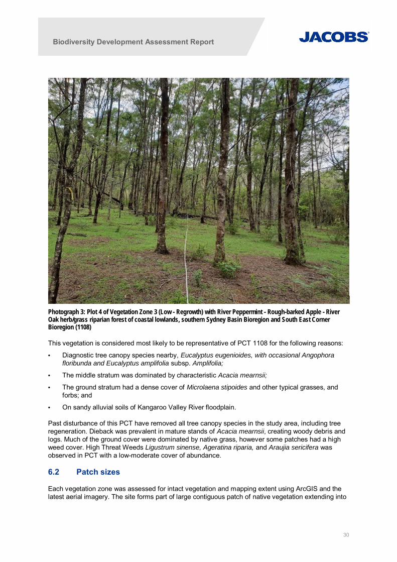
Biodiversity Development Assessment Report
30
Photograph 3: Plot 4 of Vegetation Zone 3 (Low - Regrowth) with River Peppermint - Rough-barked Apple - RiverOak herb/grass riparian forest of coastal lowlands, southern Sydney Basin Bioregion and South East CornerBioregion (1108)
This vegetation is considered most likely to be representative of PCT 1108 for the following reasons:
· Diagnostic tree canopy species nearby, Eucalyptus eugenioides, with occasional Angophorafloribunda and Eucalyptus amplifolia subsp. Amplifolia;
· The middle stratum was dominated by characteristic Acacia mearnsii;
· The ground stratum had a dense cover of Microlaena stipoides and other typical grasses, andforbs; and
· On sandy alluvial soils of Kangaroo Valley River floodplain.
Past disturbance of this PCT have removed all tree canopy species in the study area, including treeregeneration. Dieback was prevalent in mature stands of Acacia mearnsii, creating woody debris andlogs. Much of the ground cover were dominated by native grass, however some patches had a highweed cover. High Threat Weeds Ligustrum sinense, Ageratina riparia, and Araujia sericifera wasobserved in PCT with a low-moderate cover of abundance.
6.2 Patch sizes
Each vegetation zone was assessed for intact vegetation and mapping extent using ArcGIS and thelatest aerial imagery. The site forms part of large contiguous patch of native vegetation extending into

Biodiversity Development Assessment Report
31
state owned land, private property and national parks which eventually reaches the coast at JervisBay and west to the Snowy Mountains.
All vegetation zones in the site fall within the patch size class ≥100ha.This information was used in theBAM calculator to predict habitat suitability for threatened species.
6.3 Vegetation integrity results
The results of vegetation integrity scores produced by the BAM calculator (streamlined assessmentmodule) is summarised as the observed mean of all plots for composition, structure and function eachvegetation zone in Refer Table 6.2, Table 6.3 and Table 6.4.
Table 6.2 : Summary of current vegetation integrity scoresVegetationZone No.
Plant Community Type (PCT code) Current VIscores
1 Turpentine - Red Bloodwood - Sydney Peppermint shrubby open forest on the foothills,southern Sydney Basin Bioregion and northern South East Corner Bioregion (PCT1283)
48.3
2 Sydney Blue Gum x Bangalay - Lilly Pilly moist forest in gullies and on sheltered slopes,southern Sydney Basin Bioregion (PCT 1245)
58.8
3 River Peppermint - Rough-barked Apple - River Oak herb/grass riparian forest of coastallowlands, southern Sydney Basin Bioregion and South East Corner Bioregion (PCT1108)
48.9

Biodiversity Development Assessment Report
32
Table 6.3 : Summary of mean vegetation composition and structure scores
Zone Plots Trees Shrubs Grasses Forbs Ferns Other High ThreatWeed Cover
VI scores
N. spp Cover N. spp Cover N. spp Cover N. spp Cover N. spp Cover N. spp Cover Composition Structure
1 1 4 14.6 19 78.7 6 3.6 12 1.2 3 0.3 7 0.9 0 96.6 25
3 6 16.8 10 1.6 10 1.3 15 1.6 2 0.3 5 0.6 0.1
2 2 8 24.3 11 33 3 3.2 10 1 1 0.1 9 0.9 0 81.6 38.2
4 4 1 0.5 4 51.6 3 70.2 9 1 2 0.3 3 0.3 0.1 58.3 58.2
5 1 0.1 5 40.8 3 95.6 10 8.6 1 0.1 1 0.2 0.9
Table 6.4: Summary of vegetation function
Zone Plots Stem classes (1 = present, 0= absent): diameter at breast height Numberof largetrees(80+ cm)
Numberof Hollowbearingtrees
Loglengths(m)
Littercover
VI score(function)50-79 cm 30-49 cm 20-29 cm 10-19 cm 5-9 cm < 5cm
(regen)
1 1 0 1 1 1 1 1 0 0 24 79.6 46.7
3 3 1 1 1 1 1 1 0 0 11
2 2 0 1 1 1 1 1 0 0 48 95 65
4 4 0 0 0 0 0 0 0 0 44 92.8 34.4
5 0 0 0 0 0 0 0 0 17 78

----
River Peppermint -Rough-barked Apple - River Oakherb/grass riparian forestof coastal lowlands, southernSydney Basin Bioregion andSouthEast Corner Bioregion(PCT 1108)
-
Sydney Blue Gum xBangalay - Lilly Pillymoist forest in gulliesand on shelteredslopes, southern SydneyBasin Bioregion(PCT 1245)
Turpentine - Red Bloodwood - SydneyPeppermint shrubby open forest on thefoothills, southern Sydney Basin Bioregionand northern South East Corner Bioregion(PCT 1283)
e
Turpentine - RedBloodwood- Sydney Peppermintshrubby open forest onthe foothills, southernSydney Basin Biore-gion and northernSouth East CornerBioregion (PCT 1283)
JACKS CORNER ROAD
JIME D
WA
RDE
SPL
AC
E
MCP
HA
ILS
TRA
I L
KANGARO
ORIVER
Location 3
Location 4
Location 5
Location 6
Location 7
Location 8
Legend
Plots
Indicative geotechnical investigation locations (no clearing required)
Geotechnical investigation area indicative clearing
River-Flat Eucalypt Forest on Coastal Floodplains of the New South Wales North Coast, Syd-ney Basin and South East Corner Bioregions (BC Act)
Plant community types
Figure 6.1 | Distribution of Plant Community Types, TECs and VegetationZones
KIAMAMOSS VALE
0 200 400 m
Data sourcesDFSI - Spatial Services
Jacobs 2018
1:10,000 @ A4N
JAC
OB
SN
SW
SPA
TIA
L-G
ISM
APfil
e:
J:\IE
\Pro
ject
s\04
_Eas
tern
\IA19
3700
\GIS
\Dire
ctor
y\Te
mpl
ates
\Fig
ures
\Spe
cial
istR
epor
ts\B
iodi
vesi
ty\IA
1937
00_S
HPS
_Bio
_F00
1_Pl
antC
omm
unity
Type
st_r
1v1.
mxd
|18
/01/
2019

Biodiversity Development Assessment Report
34
7. Habitat Suitability for Threatened Species7.1 Ecosystem Credit Species Assessment
A list of ecosystem credit species predicted by the BAM calculator to occur within the study area are shownbelow in Table 7-1. These predictions are based on habitat assessment and PCTs identified during field survey.As the development is classified as linear, the table includes species from both the Illawarra and Ettrema IBRAsubregions. Potential for these species to occur within the survey area was assessed, and any exclusionsjustified based on habitat constraints or the species potential to utilise vegetation zones.
Table 7-1: Ecosystem Credit Species Habitat Suitability Assessment
Scientific Name Species Exclusions
Anthochaera phrygia Regent Honeyeater(foraging)
Not excluded
Callocephalon fimbriatum Gang-gang Cockatoo(foraging)
Not excluded
Calyptorhynchus lathami Glossy Black-Cockatoo(foraging)
Excluded as the geotechnical investigation locations lack suitable numbersof mature Allocasuarina spp.
Circus assimilis Spotted Harrier Not excluded
Daphoenosittachrysoptera
Varied Sittella Not excluded
Dasyurus maculatus Spotted-tailed Quoll Not excluded
Falsistrellus tasmaniensis Eastern False Pipistrelle Excluded as the geotechnical investigation locations are primarily regrowthand lacks suitable tall trees (>20m) and no tree hollows
Glossopsitta pusilla Little Lorikeet Not excluded
Haliaeetus leucogaster White-bellied Sea-Eagle(foraging)
Not excluded
Hieraaetus morphnoides Little Eagle (foraging) Not excluded
Hoplocephalusbungaroides
Broad-headed Snake(foraging)
Excluded as the geotechnical investigation locations lack suitable sun-exposed rocky habitat and exposed cliff edges
Kerivoula papuensis Golden-tipped Bat Not excluded
Lathamus discolour Swift Parrot (foraging) Excluded as the geotechnical investigation locations lack the preferred foodtrees (Eucalyptus robusta, Corymbia maculata, E. sideroxylon, E. albens)
Lophoictinia isura Square-tailed Kite(foraging)
Not excluded
Miniopterus australis Little Bentwing-bat(foraging)
Not excluded
Miniopterus schreibersiioceanensis
Eastern Bentwing-bat(foraging)
Not excluded
Mormopterusnorfolkensis
Eastern Freetail-bat Not excluded
Neophema pulchella Turquoise Parrot Not excluded
Ninox connivens Barking Owl (foraging) Not excluded
Ninox strenua Powerful Owl (foraging) Not excluded

Biodiversity Development Assessment Report
35
Scientific Name Species Exclusions
Pachycephala olivacea Olive Whistler Not excluded
Petaurus australis Yellow-bellied Glider Excluded as the geotechnical investigation locations lack mature food treesand suitable tall eucalypts with hollows for sheltering and breeding
Petroica boodang Scarlet Robin Not excluded
Petroica phoenicea Flame Robin Not excluded
Phascolarctos cinereus Koala (foraging) Excluded as the geotechnical investigation locations lack a suitableabundance of preferred food trees, as well as other eucalypts matureenough to shelter in
Potorous tridactylus Long-nosed Potoroo Not excluded
Pteropus poliocephalus Grey-headed Flying-fox(foraging)
Not excluded
Ptilinopus regina Rose-crowned Fruit-Dove Excluded as the geotechnical investigation locations are outside the species’normal range
Ptilinopus superbus Superb Fruit-dove Excluded as the geotechnical investigation locations are outside the species’normal range
Saccolaimus flaviventris Yellow-bellied Sheathtail-Bat
Not excluded
Scoteanax rueppellii Greater Broad-nosed Bat Not excluded
Stagonopleura guttata Diamond Firetail Excluded as the geotechnical investigation locations lack temperategrassland habitat and existing grassy woodland habitat is primarily shrubbyregrowth and lacking in grasses
Tyto novaehollandiae Masked Owl (foraging) Excluded as the geotechnical investigation locations lack the open woodlandwith low shrub density that the species prefers
Tyto tenebricosa Sooty Owl (foraging) Not excluded
7.2 Species Credit Species Assessment
Additional threatened fauna species identified by the BAM calculator, which have the potential to utilise thestudy area as suitable habitat are identified in Table 7-2 below. For the streamlined assessment, targetedsurveys for these species are not required, and flora species are excluded from the list. As the development isclassified as linear, the table includes species from both the Illawarra and Ettrema IBRA subregions. Speciescredit species which are in the “very high” sensitivity to gain class are highlighted.
Table 7-2: Species Credit Species Habitat Suitability Assessment
Scientific Name Species Sensitivityto GainClass
Exclusions and habitat constraints
Anthochaera phrygia Regent Honeyeater(breeding)
High Excluded as the geotechnical investigation locations lacksuitably mature eucalypts for nesting
Burhinus gallarius Bush Stone-Curlew High Not excluded - Habitat constraints of fallen/standing deadtimber were present within the geotechnical investigationlocations.
Callocephalon fimbriatum Gang-gang Cockatoo(breeding)
High Excluded as the geotechnical investigation locations lack treehollows

Biodiversity Development Assessment Report
36
Scientific Name Species Sensitivityto GainClass
Exclusions and habitat constraints
Calyptorhynchus lathami Glossy Black-Cockatoo(breeding)
High Excluded as the geotechnical investigation locations lack treehollows
Cercartetus nanus Eastern Pygmy-possum High Not excluded
Chalinolobus dwyeri Large-eared Pied Bat Very High Not excluded – geotechnical investigation locations are within2km of rocky areas containing escarpments.
Haliaeerus leucogaster White-bellied Sea-Eagle (breeding)
High Excluded as the geotechnical investigation locations lacksuitably mature eucalypts for nesting.
Heleioporus australiacus Giant Burrowing Frog Moderate Not excluded
Hieraaetus morphnoides Little eagle (breeding) Moderate Excluded as the geotechnical investigation locations lacksuitably tall trees for nesting
Hoplocephalusbungaroides
Broad-headed Snake(breeding)
Very High Excluded as the geotechnical investigation locations lacksuitable sun-exposed rocky escarpments and tree hollows
Isoodon obesulusobesulus
Southern BrownBandicoot (eastern)
High Excluded as the geotechnical investigation locations do notcontain evidence of post-fire vegetation or regular burning
Lathamus discolor Swift Parrot (breeding) Moderate Excluded as the species breeds exclusively in Tasmania
Litoria aurea Green and Golden BellFrog
High Not excluded – geotechnical investigation locations are within1km of wet areas / waterbodies.
Lophoictinia isura Square-tailed Kite(breeding)
Moderate Excluded as the geotechnical investigation locations lacksuitably large trees for breeding
Miniopterus australis Little Bentwing-Bat(breeding)
Very High Excluded as the geotechnical investigation locations lacksuitable tree hollows for breeding
Miniopterus schreibersiioceanensis
Eastern Bentwing-Bat(breeding)
Very High Excluded as the geotechnical investigation locations lacksuitable caves or man-made structures for breeding.
Mixophyes balbus Stuttering Frog Very High Excluded as the geotechnical investigation locations lacksuitable rainforest habitat, and is outside the species normalrange.
Myotis macropus Southern Myotis High Excluded as the geotechnical investigation locations lackhollow bearing trees and is greater than 200m from riparianzones.
Ninox connivens Barking Owl (breeding) High Excluded as the geotechnical investigation locations lacksuitable tree hollows for nesting
Ninox strenua Powerful Owl(breeding)
High Excluded as the geotechnical investigation locations lacksuitable tree hollows for nesting
Petaurus norfolcensis Squirrel Glider High Excluded as the geotechnical investigation locations lack thespecies preferred box/ironbark woodlands or river red gums.
Petrogale penicillate Brush-tailed Rock-wallaby
Very High Not excluded – geotechnical investigation locations are within1km of rocky escarpments.
Petroica rodinogaster Pink Robin High Excluded as the geotechnical investigation locations areoutside the species normal range
Phascolarctos cinereus Koala (breeding) High Excluded as the geotechnical investigation locations lack asuitable abundance of preferred food trees, as well as othereucalypts mature enough to shelter in

Biodiversity Development Assessment Report
37
Scientific Name Species Sensitivityto GainClass
Exclusions and habitat constraints
Pseudophryne australis Red-crowned Toadlet Moderate Not excluded
Pteropus poliocephalus Grey-headed Flying-fox(breeding)
High Excluded as the geotechnical investigation locations are notlocated in close proximity to any known roosting camps.
Sminthopsis leucopus White-footed Dunnart Moderate Not excluded
Tyto novaehollandiae Masked Owl (breeding) High Excluded as the geotechnical investigation locations lacksuitable tree hollows for nesting
Tyto tenebricosa Sooty Owl (breeding) Very High Excluded as the geotechnical investigation locations lacksuitable tree hollows for nesting
7.3 Biodiversity Risk Weighting
For streamlined assessments, biodiversity risk weighting is only required for threatened species found on thegeotechnical investigation locations. No threatened species were identified during site visits on 10 and 11January 2019 and no biodiversity risk weighting was needed.

Biodiversity Development Assessment Report
38
8. Matter of National Environmental Significance8.1 Threatened ecological communities
No threatened ecological communities listed under the EPBC Act were identified in the study area.
8.2 Threatened species
Six threatened species listed under the EPBC Act have potential foraging habitat in the study area based on thehabitat assessment in Section 7 shown above. Given that the study area is small, and much of the habitat wouldremain intact, these threatened species are considered to have a low likelihood of occurrence and anassessment of significance is not necessary. Justification for low likelihood of occurrence for each species ispresented below.
Large-eared Pied Bat (listed as vulnerable) may occur in caves within nearby escarpments, and may utilise thesite for foraging. The vegetation clearance and geotechnical work will not impact on any escarpments orpotential roosting habitat for the species. While the vegetation removal will potentially remove some foraginghabitat, the area is well connected to the surrounding landscape and the overall impacts on available foraginghabitat is low.
Green and Golden Bell Frog (listed as endangered) occurs in approximately 50 recorded locations in NSW,most of which are small, coastal, or near coastal populations. These locations occur over the species’ formerrange, however they are widely separated and isolated. Large populations in NSW are located around themetropolitan areas of Sydney, Shoalhaven and mid north coast. Waterways nearby the study area are unlikelyto support habitat for this species.
Grey-Headed Flying-Fox (listed as vulnerable) may forage in the area. No roost camps are present within thegeotechnical footprint, with the closest recorded roost camp in Kangaroo Valley, approximately 5 km away. TheGrey-headed Flying-fox is likely to limit its foraging in the area to flowering tree species, which will not beimpacted by the vegetation clearance and the overall impacts on available foraging habitat is low.
Regent Honeyeater (listed as critically endangered) may forage in the area. The vegetation clearance will avoidall trees and remove the shrub layer and understory only. While this will potentially remove some foraginghabitat for the regent honeyeater, the area is well connected to the surrounding landscape and the overallimpacts on available foraging habitat is low.
Giant Burrowing Frog (listed as vulnerable) may occur in the area. The geotechnical investigations will notimpact upon the nearby Kings Creek, and will thus have no impact on the frog’s potential breeding ground. Thefrogs may utilise other space within the vegetation clearing site as habitat during the non-breeding season.Given that the impacted area consists of a very small portion within a highly connected landscape, any impactson the burrowing frog are likely to be low.
Brush-tailed Rock-wallaby (listed as endangered) may utilise the boulders, outcrops and escarpments whichoccur near the site. These rock areas will not be impacted by the geotechnical investigations, and any adjacentvegetation clearance will be minimal, and is unlikely to impact the resources available to the Brush-tailed Rock-wallaby.
8.3 Migratory speciesUnder the EPBC Act, an action requires approval from the Australian Government Environmental Minister if theactions has, will have, or is likely to have a significant impact on a listed migratory species. An action is likely tohave a significant impact on a migratory species if there is a real chance or possibility that it will:
· Substantially modify (including by fragmenting, altering fire regimes, altering nutrient cycles or alteringhydrological cycles), destroy or isolate an area of important habitat for a migratory species

Biodiversity Development Assessment Report
39
· Result in an invasive species that is harmful to the migratory species becoming established in an area ofimportant habitat for the migratory species, or
· Seriously disrupt the lifecycle (breeding, feeding, migration or resting behaviour) of an ecologicallysignificant proportion of the population of a migratory species.
An area of ‘important habitat’ for a migratory species is:
· Habitat used by a migratory species occasionally or periodically within a region that supports anecologically significant proportion of the population of the species, and/or
· Habitat that is of critical importance to the species at particular life-cycle stages, and/or
· Habitat used by a migratory species which is at the limit of the species range, and/or
· Habitat within an area where the species is declining.
· Listed migratory species cover a broad range of species with different life cycles and population sizes.Therefore, what is an ‘ecologically significant proportion’ of the population varies with the species. Somefactors that should be considered include the species’ population status, genetic distinctiveness andspecies specific behavioural patterns (for example, site fidelity and dispersal rates). These factors havebeen considered in the following assessment.
Sixteen listed migratory species were identified in the EPBC Protected Matters Search Tool as potentiallyoccurring the locality based on the distributional range of the species and modelled habitat in the area. Thesespecies are listed in the table below.
Table 6-2 EPBC listed migratory species identified by the Protected Matters Search Tool
Species Potential to Utilize the Site?
Migratory Terrestrial Species
Fork Tailed Swift (Apus pacificus) Yes
Horsfield’s Cuckoo (Cuculus optatus) Yes
White-throated Needletail (Hirundapus caudacutus) Yes
Black-faced Monarch (Monarcha melanopsis) Yes
Spectacled Monarch (Monarcha trivirgatus) Yes
Yellow Wagtail (Motacilla flava) No – outside of normal range
Stain Flycatcher (Myiagra cyanoleuca) Yes
Rufous Fantail (Rhipidura rufifrons) Yes
Migratory Wetland Species
Common Sandpiper (Actitis hypoleucos) No
Sharp-tailed Sandpiper (Calidris acuminata) No
Curlew Sandpiper (Calidris ferruginea) No
Pectoral Sandpiper (Calidris melanotos) No
Latham’s Snipe (Gallinago hardwickii) No
Eastern Curlew (Numenius madagascariensis) No
Osprey (Pandion haliaetus) No
Common Greenshank (Tringa nebularia) No

Biodiversity Development Assessment Report
40
Seven of the eight woodland species listed are considered likely to fly over and forage within the geotechnicalinvestigations site, but would not likely use it as long-term habitat. While the area may provide some foragingopportunity for the woodland species, the site would not be classified as an “important habitat”. The remainingeight wetland species are not likely to utilise the study area. An assessment of significance for Migratoryspecies is provided as follows:
Substantially modify (including by fragmenting, altering fire regimes, altering nutrient cycles or alteringhydrological cycles), destroy or isolate an area of important habitat for a migratory species
The geotechnical investigation locations are not considered to provide important habitat for migratory speciesand are unlikely to substantially modify the habitat present.
The geotechnical investigation locations provide only marginal habitat for terrestrial migratory birds species andare very unlikely to support important habitat. This is further supported by the generally poor condition ofvegetation within. There are no breeding records from the site or surrounds and the extent of habitat remainingin the study area would provide sufficient resources to sustain future visitation.
Based on the minor and temporary nature of the geotechnical investigations, the avoidance of habitat featuresin locating works areas and access tracks and the low to moderate condition of plant community types andthreatened ecological communities present it is considered unlikely that the geotechnical investigations wouldsubstantially modify the habitat present. Following completion of geotechnical investigations, all locations wouldbe allowed to, or actively managed to, rehabilitate to their current standard.
Result in an invasive species that is harmful to the migratory species becoming established in an areaof important habitat for the migratory species
As discussed above, there is no evidence to suggest that an area of important habitat exists in the study area forany listed migratory species. Suitable measures are proposed to control the spread o f weeds during theimplementation of the geotechnical investigations.
Seriously disrupt the lifecycle (breeding, feeding, migration or resting behaviour) of an ecologicallysignificant proportion of the population of a migratory species
The background searches and field investigations found no evidence to suggest that an area of ‘importanthabitat’ exists at the site for a migratory species, or that the study area is occupied by an ecologically significantproportion of the populations of migratory species. The minor and temporary nature of the geotechnicalinvestigations would be unlikely to disrupt the lifecycle of migratory species.
Based on the above, it is therefore unlikely that the proposed works would impact on any listed migratoryspecies.

Biodiversity Development Assessment Report
41
9. Impact AssessmentThis section of the BDAR demonstrates the efforts taken to avoid and minimise impacts on biodiversity values inaccordance with Section 8 of the BAM.
Combined with appropriate mitigation measures and safeguards, the siting and planning of the geotechnicalinvestigations is expected to be sufficient to ensure that the requirements to avoid and minimise impacts onbiodiversity values as set out in Section 8 of the BAM are met. The geotechnical investigation locations andtemporary access tracks have been selected to avoid impacts on biodiversity values to the greatest extentpossible.
A key part of Origin Energy’s management of biodiversity for the geotechnical investigations is the application ofthe ‘avoid, minimise, mitigate and offset’ hierarchy as follows:
1) Avoid and minimise impacts as the highest priority;
2) Mitigate impacts where avoidance is not feasible or practicable in the particular circumstance; and
3) Offset where residual, significant unavoidable impacts would occur (if required).
9.1 Avoiding and minimising impacts on native vegetation and habitat
The selection of geotechnical investigation locations has been undertaken to target the locations of keycomponents of the Shoalhaven Hydro Expansion Project with most susceptibility to geotechnical risks, whileavoiding to the extent possible the need for clearing or ground disturbance.
The geotechnical investigations would impact on a total of 0.21 hectares of native vegetation, including:
· 0.06 ha of Endangered Ecological Communities (EECs) or Critically Endangered Ecological Communities(CEECs); and
· 0.21 ha of PCTs that contain threatened species habitat.
To avoid and minimise impacts, four of the eight locations have been positioned in cleared and previouslydisturbed areas with existing established access tracks. For the remaining four locations, clearing is beingminimised through:
· The restricted to access tracks 2 metres wide;
· Clearing only native shrubs where necessary and lopping of low lying tree branches;
· Avoiding habitat features;
· Using existing open spaces within the PCTs where available; and
· Limiting geotechnical investigation works areas to under 20m x 20m in size.
There is no area of land that the Minister for Environment has declared as an area of outstanding biodiversityvalue in accordance with Section 3.1 of the BC Act;
There are no riparian areas of 4th order or higher streams and rivers, important wetlands or estuaries; or Statesignificant biodiversity links.
9.2 Avoiding and minimising prescribed biodiversity impacts
Some types of projects may have impacts on biodiversity values in addition to, or instead of, impacts fromclearing vegetation and/or loss of habitat. For many of these impacts, the biodiversity values may be difficult toquantify, replace or offset, making avoiding and minimising impacts critical.
The BC Regulation (clause 6.1) identifies actions that are prescribed as impacts to be assessed under thebiodiversity offsets scheme:
a) Impacts of development on the habitat of threatened species or ecological communities associated with:
Biodiversity Development Assessment Report
42
i. karst, caves, crevices, cliffs and other geological features of significance; or
ii. rocks; or
iii. human made structures; or
iv. non-native vegetation.
4) Impacts of development on the connectivity of different areas of habitat of threatened species thatfacilitates the movement of those species across their range;
5) Impacts of development on movement of threatened species that maintains their life cycle;
6) Impacts of development on water quality, water bodies and hydrological processes that sustain threatenedspecies and threatened ecological communities (including from subsidence or upsidence resulting fromunderground mining);
7) Impacts of wind turbine strikes on protected animals; and
8) Impacts of vehicle strikes on threatened species or on animals that are part of a TEC.
There are no impacts to:
· Karst, caves, crevices, cliffs and other geological features of significance; or
· water quality, water bodies and hydrological processes that sustain threatened species and threatenedecological communities.
Rock habitats are present near geotechnical locations 3, 4 and 5. The project has deliberately selected anaccess route and drilling locations to avoid exposed rocks and outcrops. None of the listed habitat featureswould be impacted.
The geotechnical investigations are not a wind farm development so turbine strike is not an issue. Thegeotechnical investigations do not involve construction or upgrade of a roadway so vehicle strike is not animpact requiring consideration.
9.3 Assessment of impacts
9.3.1 Impacts on native vegetation and habitat
There is native vegetation (according to the definition of native vegetation provided in the LLS Act – see Section3.8) in the development site (see Figure 6.1). Impacts on native vegetation and habitat is assessed inaccordance with Subsections 9.1.2, 9.1.3 and 9.1.4 of the BAM. This includes:
· describing impacts on clearing of native vegetation, threatened ecological communities and threatenedspecies habitat
· describing the nature, extent, frequency, duration and timing of indirect impacts of the proposal
· describing the nature, extent, frequency, duration and timing of prescribed biodiversity impacts relevant tothe proposal
· evaluating the consequences of indirect impacts on biodiversity values
· evaluating the consequences of prescribed biodiversity impacts
· documenting any limitations to data, assumptions and predictions with respect to impacts on biodiversity
Assessing the impact of clearing native vegetation, threatened ecological communities and threatenedspecies habitat.
The geotechnical investigations will involve accessing eight locations for drilling, approximately 20m x 20m insize. Temporary access tracks will be 2 metres wide to avoid impacts to vegetation.
· Locations 1, 2, 7 and 8 are located on existing cleared land and access tracks, and no clearing ofvegetation is required.
Biodiversity Development Assessment Report
43
· Locations 3, 4 and 5 will be accessed along temporary access tracks, utilising a paper road via anovergrown gate on Jacks Corner Road. Removal of native shrubs will be required to gain access throughthe gate, including Acacia irrorata and Bursaria spinosa. The first portion of the paper road is devoid ofshrubs and trees for around 50 metres. Access to Location 3 will require removal of some native shrubsand lopping of low tree branches. Species affected will include Persoonia linearis, Leptospermumpolygalifolium, Acacia obtusifolia, Melaleuca thymifolia, Acacia ulicifolia, Melaleuca linariifolia, Breyniaobtusifolia and Leucopogon juniperinus shrubs and branches of Eucalyptus scias subsp. callimastha,Syncarpia glomulifera subsp. glomulifera and Eucalyptus eugenioides. From Location 3 through to Location5, access through dense regrowth of Kunzea ambigua and Hakea salicifolia is required and shrubs will beremoved. No trees, hollows, large logs, surface rocks will be removed during access and drilling.
· Access to Location 6 and 7 will involve using existing tracks and cleared areas as much as possible. Theselocations and access are within threatened ecological community River-Flat Eucalypt Forest on CoastalFloodplains of the New South Wales North Coast, Sydney Basin and South East Corner Bioregions. Onlyremoval of several senescent Acacia mearnsii and lopping of some branches will be required. Thegroundcover is generally dense native grass comprising Microlaena stipoides and leaf litter and willgenerally remain intact, particularly along tracks.
The future value scores for native vegetation after impact was estimated with the assumption of removing allnative shrubs and minor disturbance of groundcover within the study area. The BAM calculator was used toestimate future condition scores for composition, structure by changing shrub growth form to zero and reducingother growth form groups (except trees) in the groundcover by half for each growth form group to account forminor disturbances from drilling at geotechnical investigation locations. Lopping of tree branches wasconsidered negligible and tree growth form wasn’t changed. It is also assumed that High Threat Weed cover ofabundance would remain unchanged with weed management measures in place. Future condition scores arepresented in Table 9-1. Future function condition scores remained unchanged, as the proposed works wouldavoid impacts to these biodiversity values.
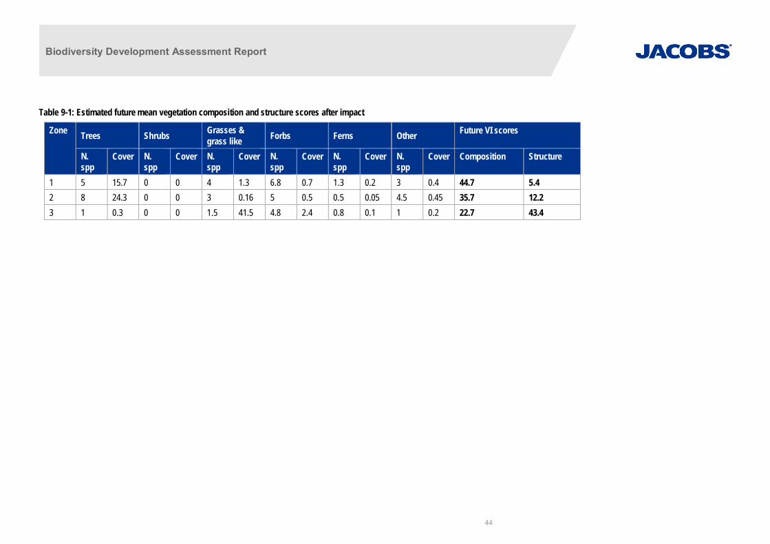
Biodiversity Development Assessment Report
44
Table 9-1: Estimated future mean vegetation composition and structure scores after impact
Zone Trees Shrubs Grasses &grass like Forbs Ferns Other Future VI scores
N.spp
Cover N.spp
Cover N.spp
Cover N.spp
Cover N.spp
Cover N.spp
Cover Composition Structure
1 5 15.7 0 0 4 1.3 6.8 0.7 1.3 0.2 3 0.4 44.7 5.42 8 24.3 0 0 3 0.16 5 0.5 0.5 0.05 4.5 0.45 35.7 12.23 1 0.3 0 0 1.5 41.5 4.8 2.4 0.8 0.1 1 0.2 22.7 43.4

Biodiversity Development Assessment Report
45
Change in the vegetation integrity score for clearing of native vegetation, threatened ecologicalcommunities threatened species habitat
The change in the vegetation integrity (VI) score is a measure of the direct impact on native vegetation andhabitat in the area. The future vegetation score was calculated by assuming a clearing of all existing vegetationexcept for the tree layer. Shrubs were also assumed to be completely cleared. Leaf litter coverage and fallentimber was assumed to remain unchanged.
Table 9-2 shows the calculated change in the VI score after the clearing of the required area.
Table 9-2: Change in Vegetation Integrity (VI) Score for all PCTs impacted by the vegetation removal
Plant Community Type Corresponding ThreatenedEcological Community (TEC)
RemovalFootprintArea (ha)
Current VIScore
Future VIScore
Change inVI Score
Turpentine - Red Bloodwood - SydneyPeppermint shrubby open forest on thefoothills, southern Sydney BasinBioregion and northern South EastCorner Bioregion (PCT 1283)
N/A 0.15 48.3 22.4 -25.9
Sydney Blue Gum x Bangalay - Lilly Pillymoist forest in gullies and on shelteredslopes, southern Sydney Basin Bioregion(PCT 1245)
N/A 0.04 58.8 30.5 -28.3
River Peppermint - Rough-barked Apple- River Oak herb/grass riparian forest ofcoastal lowlands, southern Sydney BasinBioregion and South East CornerBioregion (PCT 1108)
River-Flat Eucalypt Forest onCoastal Floodplains of the NewSouth Wales North Coast, SydneyBasin and South East CornerBioregions (BC Act)
0.02 48.9 32.4 -16.5
Total 0.21
The reduction in vegetation integrity score is largely a result of the reduction of biodiversity values in the studyarea due to the clearing of the shrub layer and understorey.
Assessing indirect impacts on native vegetation and habitat
Indirect impacts would be limited to edge effects in areas of cleared native shrubs along access tracks. Theconstruction and operation of the geotechnical investigations is restricted to a discreet area and there are noadjoining areas of native vegetation beyond the geotechnical investigation locations that would be impacted. Allequipment and resources (wastewater) brought on to site will be contained and removed from site aftercompletion. All native vegetation will already regrowing from previous disturbances and will recover afterproposed geotechnical works. Although a small amount of fauna foraging habitat will be removed it will notcreate a barrier or restrict food resources or shelter.
Proliferation of weed and pest species is an indirect impact (i.e. not a direct result of proposal activities). Themost likely causes of weed dispersal and importation associated with the geotechnical investigations includemovement of soil and attachment of seed (and other propagules) to vehicles and machinery duringtransportation to and from the geotechnical investigation locations. High threat weed species Ligustrum sinense,Ageratina riparia, and Araujia sericifera are present near and within Locations 6.
Several pathogens known from NSW have potential to impact on biodiversity as a result their movement andinfection during construction. Of these, three are listed as a key threatening process under either the EPBC Actand/or BC Act including:
· Dieback caused by Phytophthora (Root Rot; EPBC Act and BC Act);

Biodiversity Development Assessment Report
46
· Infection of frogs by amphibian chytrid fungus causing the disease chytridiomycosis (EPBC Act and BCAct); and
· Introduction and establishment of exotic Rust Fungi of the order Pucciniales on plants of the familyMyrtaceae (BC Act).
While these pathogens were not observed or tested for in the study area the potential for pathogens to occurshould be treated as a risk during geotechnical investigations. The most likely causes of pathogen dispersal andimportation associated with the geotechnical investigations include minor earthworks, movement of soil, andattachment of plant matter to vehicles and machinery during all of the project phases (construction andoperation).
There is potential for impacts to fauna from noise and vibration during geotechnical investigations, which mayresult in fauna temporarily avoiding habitats adjacent to the construction. The magnitude of this impact would below and mitigation measures are not deemed necessary.
9.3.2 Prescribed biodiversity impacts
Impacts of development on rocks that provide habitat for threatened species
The assessment of the impacts of the geotechnical investigations on the habitat of threatened species orecological communities associated with rocks must:
· Identify the species and ecological communities likely to use the habitat;
· Describe, with reference to relevant literature and other reliable published sources of information, theimportance of scattered rock for connectivity and refuge nature;
· Predict the nature, extent and duration of short and long-term impacts due to rock removal; and
· Predict the consequences of the impacts for the local and bioregional persistence of the suite of threatenedspecies and communities likely to use these areas as habitat, with reference to relevant literature and otherpublished sources of information.
Rock habitats are present near geotechnical investigation locations 3, 4 and 5. The project has deliberatelyselected temporary access routes and drilling locations to avoid exposed rocks and outcrops. No rocky habitatswill be removed. Geotechnical drilling would disturb potential subsurface bedrock near these locations, but isunlikely to affect habitat used by threatened species such as Broad-headed Snake or Rosenberg’s Goanna.
Impacts of development on the connectivity of different areas of habitat of threatened species thatfacilitates the movement of those species across their range
The geotechnical investigation locations 3, 4, 5 and 6 are located within a dense native vegetation regrowthwhere the majority of habitats have connectivity to larger contiguous areas of intact native vegetation . Thehabitats are not fragmented or isolated and facilitate the movement of threatened species across the landscape.There is physical habitat connectivity through native vegetation and associated with Kings Creek.
Functional connectivity exists for ground, arboreal and flying animals such as mammals, reptiles, birds and bats,as well as frogs in proximity to waterways.
The geotechnical investigations are considered unlikely to have a detrimental effect on habitat connectivity. Theworks are unlikely to directly impact fauna corridors but rather require lopping and trimming of tree branchesand clearing of shrubs along temporary access tracks. The only ground disturbance activity that will occur at thetemporary work areas will be the drilling of the borehole itself. The threatened species that may use thegeotechnical investigation locations are capable flyers able to cover large distances between habitat patches.Other ground species will still be able to travel through area after work is complete without any impediments.The habitats in the geotechnical investigation locations are unlikely to be important or unique in the landscapeand the geotechnical investigations will have no effect on the current dispersal and movement of speciesthroughout the locality. No barriers to movement will be introduced and no further fragmentation of habitats will
Biodiversity Development Assessment Report
47
occur. Mitigation is not required as there will be negligible impact to the bioregional persistence of threatenedspecies that currently benefit from the limited connectivity in the locality.
Impacts of the development on movement of threatened species that maintains their life cycle
The assessment of the impacts of the geotechnical investigations on movement of threatened species thatmaintains their life cycle must:
· identify movement patterns key to the life cycle of relevant threatened species that intersect with the studyarea;
· describe the nature, extent and duration of short and long-term impacts;
· describe, with reference to relevant literature and other reliable published sources of information, theimportance of the movement of the threatened species to their life cycle; and
· predict the consequences of the impacts for the bioregional persistence of the threatened species, withreference to relevant literature and other published sources of information.
The geotechnical investigation locations are located within a dense native vegetation regrowth where themajority of habitats have connectivity to larger contiguous areas of intact native vegetation . The habitats are notfragmented or isolated and facilitate the movement of threatened species across the landscape. There isphysical habitat connectivity through native vegetation and associated with Kings Creek near the geotechnicalinvestigation locations.
Functional connectivity exists for ground, arboreal and flying animals such as mammals, reptiles, birds and bats,as well as frogs in proximity to waterways.
The geotechnical investigations are considered unlikely to have a detrimental effect on movement of threatenedspecies. The geotechnical investigations are unlikely to direct impact fauna corridors but rather require loppingand trimming of tree branches and clearing of shrubs along access tracks and minor ground disturbance atdrilling sites.
No barriers to movement will be introduced and no further fragmentation of habitats will occur. The geotechnicalinvestigations locations are not part of a recognised movement corridor between breeding grounds, foraginggrounds, or other habitats important for the lifecycle of species such as staging points for migration. Mitigation isnot required as there will be negligible impact to the bioregional persistence of threatened species that currentlybenefit from the limited connectivity in the locality.
9.4 Impacts on a potential entity that are serious and irreversible impacts
There are no impacts on a potential entity that are serious and irreversible impacts. There will be no impacts toa potential serious and irreversible impact entity that is listed in the Guidance to assist a decision-maker todetermine a serious and irreversible impact that would be impacted on by the proposed development.
The geotechnical investigations will not have any serious and irreversible impacts.

Biodiversity Development Assessment Report
IA193700-0100-BD-RPT-001 48
10. Mitigating and management impacts on biodiversity valuesOnce all practicable steps to avoid or minimise impacts have been implemented at the design phase, mitigationmeasures will be implemented to further lessen the potential ecological impacts of the geotechnicalinvestigations. Mitigation measures are to be undertaken during the construction and operational phases. Theproposed techniques for implementing mitigation measures are outlined below.
The geotechnical investigations will not result in:
· removal of breeding habitat or other habitat features during construction;
· disruption to established home ranges; and
· disruption to connections between suitable habitat for foraging and dispersal.
The main impacts associated with the geotechnical investigations are those resulting from the removal of nativeshrubs and lopping of native tree branches. The potential for fauna injury or death during construction maypotentially occur due to the good condition of native vegetation and connectivity to large areas of vegetation.
10.1 Native vegetation and flora habitatThe following avoidance measures would be implemented to ensure impacts to existing vegetation and habitatis minimised:
· Where possible, vegetation clearance has been a voided or mi nimised through appropriate siting of thegeotechnical investigation locations and associated access routes in the identified locations in this report;
· Modified and degraded areas such as trails and easements have been utilised where possible;
· Lopping and direct avoidance should always be used to protect tree cover where possible, this could involvetying back tree branches during the investigation rather than lopping;
· Native vegetation shrub and ground cover should be driv en over rather than completely removed wherepossible to minimise direct impacts to smaller shrubs and tree seedlings;
· The drip-line of remnant trees is t o be avoided including storing materials and equi pment, and w henundertaking excavations;
· No native vegetation material should be removed from site; and
· Stockpile, storage and depot sit es should be si tuated in cleared/disturbed areas, such as maintainedgrassland areas and industrial lands.
10.2 Fauna habitatHabitat disturbance for threatened fauna species is generally limited to regenerating shrubs and lopping of treebranches. The following mitigation measures (as well as those listed above) would minimise fauna mortality andinjury and avoid impacts to important habitats.
No trees, hollows, large logs, surface rocks will be removed during access and drilling.
Excavations should not be left open overnight to avoid trapping fauna. If this unavoidable excavations are to beinspected prior to work commencing and any trapped fauna relocated into adjacent habitats. Excavations wouldbe backfilled as soon as possible after work on them has been completed.
10.3 Weeds and High Threat WeedsThe use of the construction machinery and exposure of the ground surface could potentially result in increasedspread of weeds including high threat weed species Ligustrum sinense, Ageratina riparia, and Araujia sericiferain Locations 6. Weed management practices need to be incorporated into the geotechnical investigationactivities to minimise the spread of weeds.
Biodiversity Development Assessment Report
IA193700-0100-BD-RPT-001 49
10.4 Water quality and hydrologyThe preservation of water quality is an important issue which needs to be managed effectively. Activitiesadjacent to Trimbles Creek. upslope of Kings Creek and up slope and within the Kangaroo Valley Riverfloodplain need to be managed to minimise sediment laden, high nutrient run-off as well as hydrocarbons andother pollutants associated with machinery. The following mitigation measures are required to minimisepotential impacts to water quality and hydrology regimes:
· At geotechnical investigation locations where there is a groundcover, no excavation should be undertakenand the existing ground layer should be protected and allowed to re-establishment following completion ofworks to minimise the area of exposed soil and encourage the regeneration of the existing native species;
· Best-practice sediment and erosion controls would be adopted where required to prevent impacts to waterquality and minimise run-off into adjacent ecologically sensitive areas where present; and
· Appropriate measures to store and manage fuels and oils are to be adopted and spill containmentequipment would be carried at all times.
10.5 Induction of Construction PersonnelGeotechnical field personnel would be made aware of the importance of the surrounding areas of threatenedecological communities and fauna habitats in the area. All geotechnical field personnel would be inducted priorto commencing and be made aware of their environmental responsibilities, including the preservation andavoidance of vegetation.

Biodiversity Development Assessment Report
IA193700-0100-BD-RPT-001 50
11. Biodiversity offsetsThe assessment of site context, native vegetation, threatened ecological communities and the assessment ofhabitat suitability for threatened species under Stage 1 of the BAM, and the location of the project in an existinglandscape suggest that the geotechnical investigation locations are appropriate for the activity.
This section of the BDAR identifies the biodiversity offsets that the assessor must apply including:
b) Impacts on a potential entity that are serious and irreversible impacts;
c) Impacts for which the assessor is required to determine an offset requirement; and
d) Impacts that do not require further assessment by the assessor.
The process of site selection and documented mitigation strategy has aimed at avoiding and minimising impactsto biodiversity in the first instance. There would be no significant biodiversity impacts associated with thegeotechnical investigations and only minor residual impacts on biodiversity values on PCTs and low conditionTECs would remain. In accordance with the BAM these residual impacts are required to be offset and thequantum of biodiversity credits required have been calculated using the online BAM calculator. Only ecosystemcredits were calculated based on the future condition of PCTs limited to residual impacts in the impact area andare summarised in Table 11-1.
Table 11-1 Summary of plant community types future and change in vegetation integrity score and associated number ofecosystem credits required for offset.
Plant Community Type Footprintimpact area(ha)
Future VIscore (afterimpact)
Total changein VI score(after impact)
Ecosystemcreditsrequired
Turpentine - Red Bloodwood - SydneyPeppermint shrubby open forest on the foothills,southern Sydney Basin Bioregion and northernSouth East Corner Bioregion (PCT 1283)
0.15 22.4 -25.5 1
Sydney Blue Gum x Bangalay - Lilly Pilly moistforest in gullies and on sheltered slopes,southern Sydney Basin Bioregion (PCT 1245)
0.04 30.5 -28.3 1
River Peppermint - Rough-barked Apple - RiverOak herb/grass riparian forest of coastallowlands, southern Sydney Basin Bioregion andSouth East Corner Bioregion (PCT 1108)River-Flat Eucalypt Forest on CoastalFloodplains of the New South Wales NorthCoast, Sydney Basin and South East CornerBioregions (BC Act)
0.02 32.4 -16.5 1
Total 0.21 - 3

Biodiversity Development Assessment Report
IA193700-0100-BD-RPT-001 51
12. Summary and ConclusionsThe Biodiversity Offset Scheme applies to State Significant Infrastructure projects unless the Secretary of theDepartment of Planning and Environment and the Chief Executive of OEH determine that the project is not likelyto have a significant impact. This document is the BDAR for the project as required under the BiodiversityAssessment Method (BAM). This BDAR documents the results of the biodiversity streamlined assessmentundertaken for the geotechnical investigations is in line with the relevant State and Commonwealthenvironmental and threatened species legislation and policy.
Based on the minor and temporary nature of the geotechnical investigations, the avoidance of habitat featuresin locating works areas and access tracks and the low to moderate condition of plant community types andthreatened ecological communities present it is considered unlikely that significant impacts to biodiversity valueswould occur. Following completion of the geotechnical investigations, all locations would be allowed to, oractively managed to, rehabilitate to their current standard.
There is unlikely to be any significant impacts to any threatened ecological communities and threatened ormigratory species listed as a Matter of National Environmental Significance. The geotechnical investigations donot require a referral to the Federal Department of the Environment and Energy for these matters.
Other impacts relevant to the geotechnical investigations in relation to the BAM include prescribed impacts. Theprescribed impacts of relevance include:
· Impacts of development on rocks that provide habitat for threatened species;
· Impacts of development on the connectivity of different areas of habitat of threatened species thatfacilitates the movement of those species across their range; and
· Impacts of the development on movement of threatened species that maintains their life cycle.
The effects of the prescribed impacts are considered to be minor in the context of the geotechnicalinvestigations and would likely be avoided.
There are no impacts on a potential entity that are serious and irreversible impacts. Overall, the biodiversityimpacts of the geotechnical investigations are considered to be minor but some mitigation is required and will beplanned.
No clearing or permanent impacts are proposed in areas mapped as Key Fish Habitat and with all drilling waterand wastes to be contained and disposed of off site no impacts to Key Fish Habitat are likely.

Biodiversity Development Assessment Report
IA193700-0100-BD-RPT-001 52
13. ReferencesDepartment Of Environment And Climate Change. (2008). Descriptions for NSW (Mitchell) Landscapes Version2 (2002) [Online]. Available:http://maps.environment.nsw.gov.au/Metadata/NSW%20Landscapes%20descriptions.pdf 2010].
NSW National Parks And Wildlife Service. (2002). Landscapes (Mitchell) of NSW. Hurstville NSW NationalParks and Wildlife Service.
NSW Office Of Environment And Heritage (2011). Climate Change Corridors (Dry Habitat) for North East NSW.Bioregional Assessment Source Dataset.
NSW Office Of Environement And Heritage, (2017). Biodiversiy Assessment Method. NSW Government.
SA Department Of Environment Water And Natural Resources. (2015). IBRA Subregion Australia Version 7.0 -PED. Bioregional Assessment Source Dataset. [Online]. Available:http://data.bioregionalassessments.gov.au/dataset/e5a6d60a-009c-4fc3-b27d-67ed108b38ba.
Tozer MG, Turner K, Keith DA, Tindall D, Pennay C, Simpson C, MacKenzie B, Beukers P (2010) Nativevegetation of southeast NSW: a revised classification and map for the coast and eastern tablelands.Cunninghamia 11, 359-406. Botanic gardens Trust, Sydney

Biodiversity Development Assessment Report
IA193700-0100-BD-RPT-001
Appendix A. Likelihood of occurrenceLikelihood of occurrence indicates how likely it is that a threatened species will be present within the study area. Species are assigned a likelihood of occurrence from unlikelyto high based on the following criteria:
Likelihood of Occurrence Criteria
Unlikely · Species highly restricted to certain geographical areas not within the proposal footprint· Species has specific habitat requirements that are not present in the study area
Low Species that fit into one or more of the following criteria:· Have not been recorded previously in the study area/surrounds, and for which the study area is beyond the current distribution range· Use specific habitats or resources not present in the study area.· Are non-cryptic perennial flora species that were targeted by surveys and were not recorded.
Moderate Species that fit into one or more of the following criteria:· Have infrequently been recorded previously in the study area/surrounds· Use specific habitats or resources present in the study area but it poor or modified condition· Are unlikely to maintain sedentary populations, however may seasonally use resources within the study area opportunistically or during
migration· Are cryptic flowering species what were not seasonally targeted by surveys and have not been recorded.
High Species that fit into one or more of the following criteria:· Have frequently been recorded previously in the study area/surrounds· Use habitat types or resources that are present in the study area in abundance and/or in good condition· Are known or likely to maintain resident populations surrounding the study area· Are known or likely to visit the site during regular seasonal movements or migration

Biodiversity Development Assessment Report
IA193700-0100-BD-RPT-001
Species BC Act EPBC Act Distribution and Habitat Data Source
*see notes on page 1
Likelihood ofOccurrence withinproposal area
TargetedSurvey Timing
*BAM P: Means species was listed in the BAM Predicted Species Report based on PCTs
*BAM C: Means the species was listed in the BAM Candidate Species Report based on PCTs
*# records: number of records from OEH BioNet Species Sightings Search
Birds
Burhinus grallariusBush Stone-curlew
E - Open forests and woodlands with a sparse grassyground layer and fallen timber.
BAM C Low Year round
Calyptorhynchus lathamiGlossy Black-Cockatoo
V - The species is uncommon although widespreadthroughout suitable forest and woodland habitats,from the central Queensland coast to East Gippslandin Victoria, and inland to the southern tablelands andcentral western plains of NSW, with a smallpopulation in the Riverina. An isolated populationexists on Kangaroo Island, South Australia. Inhabitsopen forest and woodlands of the coast and the GreatDividing Range where stands of Sheoak occur. BlackSheoak (Allocasuarina littoralis) and Forest Sheoak(A. torulosa) are important foods. Inland populationsfeed on a wide range of Sheoaks, including DroopingSheoak, Allocasuarina diminuta, and A. gymnanthera.Belah is also utilised and may be a critical foodsource for some populations. In the Riverina, birdsare associated with hills and rocky rises supportingDrooping Sheoak, but also recorded in openwoodlands dominated by Belah (Casuarina cristata).
BioNet Atlas 8RecordsBAM P
Low Mar-Aug
Lathamus discolorSwift Parrot
E CE Where eucalypts are flowering profusely or wherethere is abundant lerp infestations. Favour SwampMahogany (Eucalyptus robusta), Spotted Gum(Corymbia maculata), Red Ironbark (E. sideroxylon),and White Box (E. albens).
PMSTBAM P C
Low May-Aug
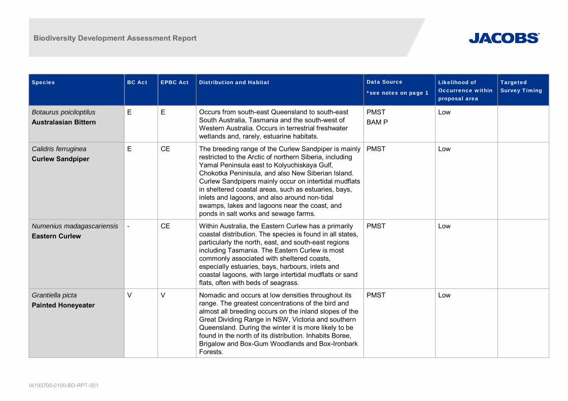
Biodiversity Development Assessment Report
IA193700-0100-BD-RPT-001
Species BC Act EPBC Act Distribution and Habitat Data Source
*see notes on page 1
Likelihood ofOccurrence withinproposal area
TargetedSurvey Timing
Botaurus poiciloptilusAustralasian Bittern
E E Occurs from south-east Queensland to south-eastSouth Australia, Tasmania and the south-west ofWestern Australia. Occurs in terrestrial freshwaterwetlands and, rarely, estuarine habitats.
PMSTBAM P
Low
Calidris ferrugineaCurlew Sandpiper
E CE The breeding range of the Curlew Sandpiper is mainlyrestricted to the Arctic of northern Siberia, includingYamal Peninsula east to Kolyuchiskaya Gulf,Chokotka Peninisula, and also New Siberian Island.Curlew Sandpipers mainly occur on intertidal mudflatsin sheltered coastal areas, such as estuaries, bays,inlets and lagoons, and also around non-tidalswamps, lakes and lagoons near the coast, andponds in salt works and sewage farms.
PMST Low
Numenius madagascariensisEastern Curlew
- CE Within Australia, the Eastern Curlew has a primarilycoastal distribution. The species is found in all states,particularly the north, east, and south-east regionsincluding Tasmania. The Eastern Curlew is mostcommonly associated with sheltered coasts,especially estuaries, bays, harbours, inlets andcoastal lagoons, with large intertidal mudflats or sandflats, often with beds of seagrass.
PMST Low
Grantiella pictaPainted Honeyeater
V V Nomadic and occurs at low densities throughout itsrange. The greatest concentrations of the bird andalmost all breeding occurs on the inland slopes of theGreat Dividing Range in NSW, Victoria and southernQueensland. During the winter it is more likely to befound in the north of its distribution. Inhabits Boree,Brigalow and Box-Gum Woodlands and Box-IronbarkForests.
PMST Low

Biodiversity Development Assessment Report
IA193700-0100-BD-RPT-001
Species BC Act EPBC Act Distribution and Habitat Data Source
*see notes on page 1
Likelihood ofOccurrence withinproposal area
TargetedSurvey Timing
A specialist feeder on the fruits of mistletoes growingon woodland eucalypts and acacias. Prefersmistletoes of the genus Amyema.
Rostratula australisAustralian Painted Snipe
E E Most records are from the south east, particularly theMurray Darling Basin, with scattered records acrossnorthern Australia and historical records from aroundthe Perth region in Western Australia. Prefers fringesof swamps, dams and nearby marshy areas wherethere is a cover of grasses, lignum, low scrub or opentimber. Nests on the ground amongst tall vegetation,such as grasses, tussocks or reeds.
PMST Unlikely
Lophoictinia isuraSquare-tailed Kite
V - In NSW it is often associated with ridge and gullyforests dominated by Eucalyptus longifolia, Corymbiamaculata, E. elata, or E. smithii. Individuals appear tooccupy large hunting ranges of more than 100 km2.They require large living trees for breeding,particularly near water with surrounding woodland/forest close by for foraging habitat. Nest sites aregenerally located along or near watercourses, in atree fork or on large horizontal limbs.
BioNet Atlas 1RecordBAM P C
Low Sep-Jan
Hieraaetus morphnoidesLittle Eagle
V - Occupies open eucalypt forest, woodland or openwoodland. Sheoak or Acacia woodlands and riparianwoodlands of interior NSW are also used.
BAM P C Low Aug-Oct
Haliaeetus leucogasterWhite-bellied Sea-Eagle
V M Found in coastal habitats and terrestrial wetlands intropical and temperate regions of mainland Australiaand its offshore islands. Nests require living or deadmature trees within suitable vegetation within 1km ofrivers, lakes, large dams or creeks, wetlands andcoastlines
BAM P C Low Jul-Dec
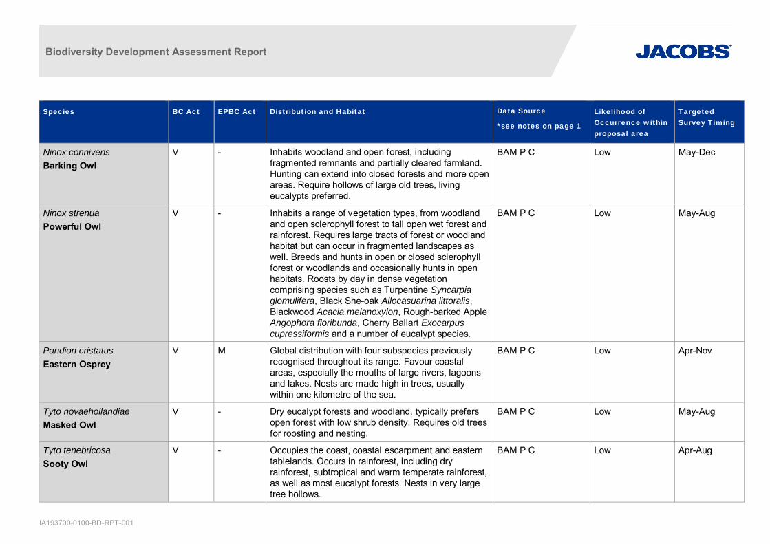
Biodiversity Development Assessment Report
IA193700-0100-BD-RPT-001
Species BC Act EPBC Act Distribution and Habitat Data Source
*see notes on page 1
Likelihood ofOccurrence withinproposal area
TargetedSurvey Timing
Ninox connivensBarking Owl
V - Inhabits woodland and open forest, includingfragmented remnants and partially cleared farmland.Hunting can extend into closed forests and more openareas. Require hollows of large old trees, livingeucalypts preferred.
BAM P C Low May-Dec
Ninox strenuaPowerful Owl
V - Inhabits a range of vegetation types, from woodlandand open sclerophyll forest to tall open wet forest andrainforest. Requires large tracts of forest or woodlandhabitat but can occur in fragmented landscapes aswell. Breeds and hunts in open or closed sclerophyllforest or woodlands and occasionally hunts in openhabitats. Roosts by day in dense vegetationcomprising species such as Turpentine Syncarpiaglomulifera, Black She-oak Allocasuarina littoralis,Blackwood Acacia melanoxylon, Rough-barked AppleAngophora floribunda, Cherry Ballart Exocarpuscupressiformis and a number of eucalypt species.
BAM P C Low May-Aug
Pandion cristatusEastern Osprey
V M Global distribution with four subspecies previouslyrecognised throughout its range. Favour coastalareas, especially the mouths of large rivers, lagoonsand lakes. Nests are made high in trees, usuallywithin one kilometre of the sea.
BAM P C Low Apr-Nov
Tyto novaehollandiaeMasked Owl
V - Dry eucalypt forests and woodland, typically prefersopen forest with low shrub density. Requires old treesfor roosting and nesting.
BAM P C Low May-Aug
Tyto tenebricosaSooty Owl
V - Occupies the coast, coastal escarpment and easterntablelands. Occurs in rainforest, including dryrainforest, subtropical and warm temperate rainforest,as well as most eucalypt forests. Nests in very largetree hollows.
BAM P C Low Apr-Aug

Biodiversity Development Assessment Report
IA193700-0100-BD-RPT-001
Species BC Act EPBC Act Distribution and Habitat Data Source
*see notes on page 1
Likelihood ofOccurrence withinproposal area
TargetedSurvey Timing
Circus assimilisSpotted Harrier
V - The Spotted Harrier occurs throughout the Australianmainland, except in densely forested or woodedhabitats of the coast, escarpment and ranges, andrarely in Tasmania. Individuals disperse widely inNSW and comprise a single population. Occurs ingrassy open woodland including Acacia and malleeremnants, inland riparian woodland, grassland andshrub steppe. It is found most commonly in nativegrassland, but also occurs in agricultural land,foraging over open habitats including edges of inlandwetlands.
BAM P Low
Anthochaera phrygiaRegent Honeyeater
CE CE Dry open forest in temperate woodlands, particularlyBox-Ironbark woodland, and riparian forests of RiverSheoak. Nest in horizontal branches or forks in tallmature eucalypts and Sheoaks.
PMSTBAM P
Low Sep-Dec
Callocephalon fimbriatumGang-gang Cockatoo
V - In summer, tall montane forests and woodlands,particularly in heavily timbered and mature wetsclerophyll forests. In winter, lower altitudes in drier,more open eucalypt woodlands. Require tree hollowsfor breeding.
BioNet Atlas 12recordsBAM P C
Low Oct-Jan
Petroica rodinogasterPink Robin
V - On the mainland, the species disperses north andwest and into more open habitats in winter, regularlyas far north as the ACT area, and sometimes beingfound as far north as the central coast of NSW.Inhabits rainforest and tall, open eucalypt forest,particularly in densely vegetated gullies.
BAM C Low Year round
Petroica phoeniceaFlame Robin
V - The Flame Robin is endemic to south easternAustralia, and ranges from near the Queenslandborder to south east South Australia and also inTasmania. In NSW, it breeds in upland areas and in
BAM P Low

Biodiversity Development Assessment Report
IA193700-0100-BD-RPT-001
Species BC Act EPBC Act Distribution and Habitat Data Source
*see notes on page 1
Likelihood ofOccurrence withinproposal area
TargetedSurvey Timing
winter, many birds move to the inland slopes andplains. It is likely that there are two separatepopulations in NSW, one in the Northern Tablelands,and another ranging from the Central to SouthernTablelands. Breeds in upland tall moist eucalyptforests and woodlands, often on ridges and slopes.Prefers clearings or areas with open understoreys.The groundlayer of the breeding habitat is dominatedby native grasses and the shrub layer may be eithersparse or dense. Occasionally occurs in temperaterainforest, and also in herbfields, heathlands,shrublands and sedgelands at high altitudes.
Petroica boodangScarlet Robin
V - The Scarlet Robin lives in dry eucalypt forests andwoodlands. The understorey is usually open andgrassy with few scattered shrubs. This species lives inboth mature and re-growth vegetation. It occasionallyoccurs in mallee or wet forest communities, or inwetlands and tea-tree swamps.
BioNet Atlas 4recordsBAM P
Low
Artamus cyanopterusDusky Woodswallow
V - Dusky woodswallows are widespread in eastern,southern and south western Australia. The speciesoccurs throughout most of New South Wales, but issparsely scattered in, or largely absent from, much ofthe upper western region. Most breeding activityoccurs on the western slopes of the Great DividingRange.
BioNet Atlas 4records
Low Year round
Dasyornis brachypterusEastern Bristlebird
E E The distribution of the Eastern Bristlebird hascontracted to three disjunct areas of south-easternAustralia. There are three main populations: Northern- southern Queensland/northern NSW, Central -Barren Ground NR, Budderoo NR, Woronora Plateau,Jervis Bay NP, Booderee NP and Beecroft Peninsula
PMSTBioNet Atlas 2records
Low

Biodiversity Development Assessment Report
IA193700-0100-BD-RPT-001
Species BC Act EPBC Act Distribution and Habitat Data Source
*see notes on page 1
Likelihood ofOccurrence withinproposal area
TargetedSurvey Timing
and Southern - Nadgee NR and Croajingalong NP inthe vicinity of the NSW/Victorian border. Theestimated population size is less than 2000individuals occupying a total area of about 120 sq km.There are now only four populations in the southernQueensland/northern NSW area with a total of 35birds, compared to 15 years ago when 14 populationsand 154 birds were recorded. This population onceextended as far south as at least Dorrigo and hasrecently been identified as a separate ultrataxon(monoides) but further research is being undertakento determine the validity of this. The remainingpopulations are the nominate ultrataxon(brachypterus) and once extended at least to what isnow the Sydney urban area. The central populationcomprises an estimated 1600 birds, mainly fromBarren Grounds Nature Reserve, Budderoo NationalPark and the Jervis Bay area. The southernpopulation in Nadgee Nature Reserve and Howe'sFlat is around 200 birds. Further surveys are requiredin parts of Ben Boyd National Park and SydneyCatchment Authority lands to determine whetherfurther populations of the Eastern Bristlebird occur inthese areas.
Daphoenositta chrysopteraVaried Sittella
V - The Varied Sittella is sedentary and inhabits most ofmainland Australia except the treeless deserts andopen grasslands. Distribution in NSW is nearlycontinuous from the coast to the far west. The VariedSittella's population size in NSW is uncertain but isbelieved to have undergone a moderate reductionover the past several decades. Inhabits eucalyptforests and woodlands, especially those containing
BioNet Atlas 2recordsBAM P
Low
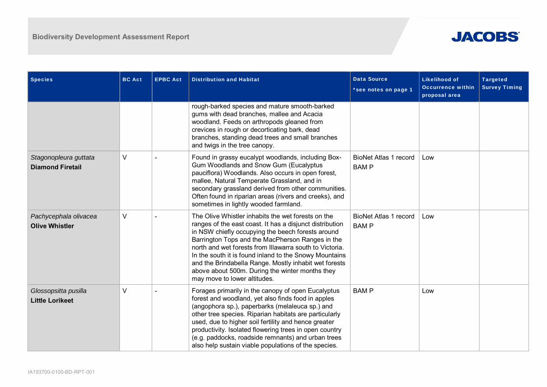
Biodiversity Development Assessment Report
IA193700-0100-BD-RPT-001
Species BC Act EPBC Act Distribution and Habitat Data Source
*see notes on page 1
Likelihood ofOccurrence withinproposal area
TargetedSurvey Timing
rough-barked species and mature smooth-barkedgums with dead branches, mallee and Acaciawoodland. Feeds on arthropods gleaned fromcrevices in rough or decorticating bark, deadbranches, standing dead trees and small branchesand twigs in the tree canopy.
Stagonopleura guttataDiamond Firetail
V - Found in grassy eucalypt woodlands, including Box-Gum Woodlands and Snow Gum (Eucalyptuspauciflora) Woodlands. Also occurs in open forest,mallee, Natural Temperate Grassland, and insecondary grassland derived from other communities.Often found in riparian areas (rivers and creeks), andsometimes in lightly wooded farmland.
BioNet Atlas 1 recordBAM P
Low
Pachycephala olivaceaOlive Whistler
V - The Olive Whistler inhabits the wet forests on theranges of the east coast. It has a disjunct distributionin NSW chiefly occupying the beech forests aroundBarrington Tops and the MacPherson Ranges in thenorth and wet forests from Illawarra south to Victoria.In the south it is found inland to the Snowy Mountainsand the Brindabella Range. Mostly inhabit wet forestsabove about 500m. During the winter months theymay move to lower altitudes.
BioNet Atlas 1 recordBAM P
Low
Glossopsitta pusillaLittle Lorikeet
V - Forages primarily in the canopy of open Eucalyptusforest and woodland, yet also finds food in apples(angophora sp.), paperbarks (melaleuca sp.) andother tree species. Riparian habitats are particularlyused, due to higher soil fertility and hence greaterproductivity. Isolated flowering trees in open country(e.g. paddocks, roadside remnants) and urban treesalso help sustain viable populations of the species.
BAM P Low

Biodiversity Development Assessment Report
IA193700-0100-BD-RPT-001
Species BC Act EPBC Act Distribution and Habitat Data Source
*see notes on page 1
Likelihood ofOccurrence withinproposal area
TargetedSurvey Timing
Neophema pulchellaTurquoise Parrot
V - Range extends from southern Queensland through tonorthern Victoria, from the coastal plains to thewestern slopes of the Great Dividing Range. Lives onthe edges of eucalypt woodland adjoining clearings,timbered ridges and creeks in farmland.
BAM P Low
Ptilinopus reginaRose-crowned Fruit Dove
V - Coast and ranges of eastern NSW and Queensland,from Newcastle to Cape York. Vagrants areoccasionally found further south to Victoria. Rose-crowned Fruit-doves occur mainly in sub-tropical anddry rainforest and occasionally in moist eucalyptforest and swamp forest, where fruit is plentiful.
BAM P Low
Ptilinopus superbusSuperb Fruit-Dove
V - The Superb Fruit-dove occurs principally from north-eastern in Queensland to north-eastern NSW.Inhabits rainforest and similar closed forests where itforages high in the canopy, eating the fruits of manytree species such as figs and palms. It may alsoforage in eucalypt or acacia woodland where thereare fruit-bearing trees.
BAM P Low
Ixobrychus flavicollisBlack Bittern
V - Occurs from south-east Queensland to south-eastSouth Australia, Tasmania and the south-west ofWestern Australia. Occurs in terrestrial freshwaterwetlands and, rarely, estuarine habitats.
BAM P Low
Mammals
Chalinolobus dwyeriLarge-eared Pied Bat
V V Forages over a broad range of open forest andwoodland habitats. Cave roosting bat which favourssandstone escarpment habitats for roosting, inshallow overhands, crevices, and caves.
PMSTBAM C
Low Sep-Mar
Cercartetus nanus V - Found in a broad range of habitats from rainforestthrough to wet and dry sclerophyll forest and
BAM C Low October-March

Biodiversity Development Assessment Report
IA193700-0100-BD-RPT-001
Species BC Act EPBC Act Distribution and Habitat Data Source
*see notes on page 1
Likelihood ofOccurrence withinproposal area
TargetedSurvey Timing
Eastern Pygmy-possum woodland to heath, but in most areas woodlands andheath appear to be preferred.
Dasyurus maculatusSpotted-tail Quoll
V E Wet and dry sclerophyll forests and rainforests, andadjacent open agricultural areas. Generallyassociated with large expansive areas of habitat tosustain territory size. Requires hollow-bearing trees,fallen logs, small caves, rock crevices, boulder fieldsand rocky-cliff faces as den sites.
PMSTBioNet Atlas 6recordsBAM P
Low
Miniopterus australisLittle Bentwing-bat
V - Eastern coast and ranges from Cape York toWollongong. Roost in caves, tunnels, tree hollows,stormwater drains, culverts, bridges, and sometimebuildings.
BAM P C Low Dec-Feb
Miniopterus schreibersiioceanensisEastern Bentwing-bat
V - East and north-west coasts of Australia. Primarilyroost in caves, but also use abandoned mines,stormwater tunnels, buildings and other man-madestructures.
BioNet Atlas 7recordsBAM P C
Low Nov-Feb
Mormopterus norfolkensisEastern Freetail-bat
V - Occur in dry sclerophyll forest and woodland east ofthe Great Dividing Range. Roosts mainly in treehollows but will also roost under bark or in human-made structures.
BioNet Atlas 6recordsBAM P
Low
Myotis macropusSouthern Myotis
V Roosts close to water in caves, mine shafts, hollow-bearing trees, buildings, bridges, and in dense foliage.Forages over streams and ponds.
BioNet Atlas 2recordsBAM C
Low Nov-Mar
Kerivoula papuensisGolden-tipped Bat
V - The Golden-tipped Bat is distributed along the eastcoast of Australia in scattered locations from CapeYork Peninsula in Queensland to south of Eden insouthern NSW. It also occurs in New Guinea. Foundin rainforest and adjacent wet and dry sclerophyll
BAM P Low

Biodiversity Development Assessment Report
IA193700-0100-BD-RPT-001
Species BC Act EPBC Act Distribution and Habitat Data Source
*see notes on page 1
Likelihood ofOccurrence withinproposal area
TargetedSurvey Timing
forest up to 1000m. Also recorded in tall open forest,Casuarina-dominated riparian forest and coastalMelaleuca forests. Roost mainly in rainforest gullieson small first- and second-order streams in usuallyabandoned hanging Yellow-throated Scrubwren andBrown Gerygone nests modified with an access holeon the underside. Bats may also roost under thickmoss on tree trunks, in tree hollows, dense foliageand epiphytes.
Scoteanax rueppelliiGreater Broad-nosed Bat
V - Utilises a variety of habitats from woodland through tomoist and dry eucalypt forest and rainforest, though itis most commonly found in tall wet forest. Althoughthis species usually roosts in tree hollows, it has alsobeen found in buildings.
BAM P Low
Saccolaimus flaviventrisYellow-bellied SheathtailBat
V - Wide-ranging species found across northern andeastern Australia. Roosts singly or in groups of up tosix, in tree hollows and buildings; in treeless areasthey are known to utilise mammal burrows.
BAM P Low
Phascolarctos cinereusKoala
V V In NSW it mainly occurs on the central and northcoasts with some populations in the west of the GreatDividing Range. Inhabit eucalypt woodlands andforests. Feed on the foliage of more than 70 eucalyptspecies and 30 non-eucalypt species, but in any onearea will select preferred browse species.
PSMTBioNet Atlas 1 recordBAM P C
Low Year round
Pteropus poliocephalusGrey-headed Flying-fox
V V Generally found within 200kn of the eastern coast.Occur in subtropical and temperate rainforests, tallsclerophyll forests and woodlands, heaths andswamps as well as urban gardens and cultivated fruitcrops. Roosting camps are generally located within 20km of a regular food source and are commonly found
PMSTBioNet Atlas 4recordsBAM P C
Low October-December

Biodiversity Development Assessment Report
IA193700-0100-BD-RPT-001
Species BC Act EPBC Act Distribution and Habitat Data Source
*see notes on page 1
Likelihood ofOccurrence withinproposal area
TargetedSurvey Timing
in gullies, close to water, in vegetation with a densecanopy.
Potorous tridactylusLong-nosed Potoroo
V V The long-nosed potoroo is found on the south-easterncoast of Australia, from Queensland to easternVictoria and Tasmania, including some of the BassStrait islands. Inhabits coastal heaths and dry and wetsclerophyll forests. Dense understorey withoccasional open areas is an essential part of habitat,and may consist of grass-trees, sedges, ferns orheath, or of low shrubs of tea-trees or melaleucas. Asandy loam soil is also a common feature. The fruit-bodies of hypogeous (underground-fruiting) fungi area large component of the diet of the Long-nosedPotoroo. They also eat roots, tubers, insects and theirlarvae and other soft-bodied animals in the soil.
PSMTBioNet Atlas 8recordsBAM P
Low
Pseudomys novaehollandiaeNew Holland Mouse
V Distribution is fragmented across all eastern states ofAustralia, where it inhabits open heath lands, openwoodlands with heath understorey and vegetatedsand dunes.
PMST Low
Isoodon obesulus obesulusSouthern Brown Bandicoot(eastern)
E E This species prefers sandy soils with scrubbyvegetation and/or areas with low ground cover thatare burned from time to time. A mosaic of post firevegetation is important for this species.
PMST Low Year round
Petaurus norfolcensisSquirrel Glider
V - Dispersed widely but sparsely through easternAustralia. Prefers mixed species stands with a shrubor Acacia midstorey.
BioNet Atlas 1 recordBAM C
Low Year round
Petrogale penicillataBrush-tailed Rock-wallaby
E V Range follows roughly the line of the Great DividingRange. Occupies rocky escarpments, outcrops, and
PMSTBioNet Atlas 14records
Low Year Round

Biodiversity Development Assessment Report
IA193700-0100-BD-RPT-001
Species BC Act EPBC Act Distribution and Habitat Data Source
*see notes on page 1
Likelihood ofOccurrence withinproposal area
TargetedSurvey Timing
cliffs with a preference for complex structures. Browseon vegetation in and adjacent to rocky areas.
BAM C
Sminthopsis leucopusWhite-footed Dunnart
The White-footed Dunnart occurs in Tasmania andalong the Victorian and southern NSW coast. TheShoalhaven area is the species' northern-most limit. Ithas not been recorded west of the coastalescarpment with the western-most record being fromCoolangubra State Forest, approximately 10 kmsouth-east of Bombala. In NSW, the species seems tofavour vegetation communities with an openunderstorey structure (contrasting with populations inVictoria which apparently prefer dense shrub andground layers). It is patchily distributed across thesehabitats and, where present, typically occurs at lowdensities. Breeding populations have been recordedin logged forest shortly after disturbance, but theseusually do not persist as regeneration proceeds and adense ground cover of vegetation establishes.
BAM C Low
Petaurus australisYellow-bellied Glider
V - Found along the eastern coast to the western slopesof the Great Dividing Range, from southernQueensland to Victoria. Occur in tall mature eucalyptforest generally in areas with high rainfall and nutrientrich soils. Forest type preferences vary with latitudeand elevation; mixed coastal forests to dryescarpment forests in the north; moist coastal gulliesand creek flats to tall montane forests in the south.Feed primarily on plant and insect exudates, includingnectar, sap, honeydew and manna with pollen andinsects providing protein. Extract sap by incising (orbiting into) the trunks and branches of favoured foodtrees, often leaving a distinctive ‘V’-shaped scar.
BioNet Atlas 12recordsBAM P
Low

Biodiversity Development Assessment Report
IA193700-0100-BD-RPT-001
Species BC Act EPBC Act Distribution and Habitat Data Source
*see notes on page 1
Likelihood ofOccurrence withinproposal area
TargetedSurvey Timing
Falsistrellus tasmaniensisEastern False Pipistrelle
V - The Eastern False Pipistrelle is found on the south-east coast and ranges of Australia, from southernQueensland to Victoria and Tasmania.
BioNet Atlas 1 recordBAM P
Low
Petauroides volansGreater Glider
- V The Greater Glider occurs in eucalypt forests andwoodlands along the east coast of Australia fromnorth east Queensland to the Central Highlands ofVictoria. This population of Greater Gliders on thesouth coast of NSW is bounded by the Moruya Riverto the north, Coila Lake to the south and the PrincesHighway and cleared land exceeding 700 m in widthto the west. Feeds exclusively on eucalypt leaves,buds, flowers and mistletoe. Shelter during the day intree hollows and will use up to 18 hollows in theirhome range. Occupy a relatively small home rangewith an average size of 1 to 3 ha.
PMSTBioNet Atlas 2records
Low
Reptiles & Amphibians
Hoplocephalus bungaroidesBroad-headed Snake
V V Shelters in rock crevices and under flat sandstonerocks on exposed cliff edges during autumn, winterand spring. Shelters in hollows of large trees within200m of escarpments in summer
BioNet Atlas 2recordsBAM P C
Low Aug-Sep
Litoria aureaGreen and Golden Bell Frog
E V 50 recorded locations in NSW, mostly coastal or nearcoastal. Large populations are located aroundmetropolitan Sydney, Shoalhaven, and mid northcoast.
PMSTBAM C
Low November-March
Mixophyes balbusStuttering Frog
V V Found in rainforest and wet, tall open forest in thefoothills and escarpment on the eastern side of theGreat Dividing Range. Outside the breeding seasonadults live in deep leaf litter and thick understoreyvegetation on the forest floor.
PMSTBAM C
Low Sep-Mar

Biodiversity Development Assessment Report
IA193700-0100-BD-RPT-001
Species BC Act EPBC Act Distribution and Habitat Data Source
*see notes on page 1
Likelihood ofOccurrence withinproposal area
TargetedSurvey Timing
Heleioporus australiacusGiant Burrowing Frog
V V Northern population largely confined to the sandstonegeology of the Sydney Basin and extending as farsouth as Ulladulla. Found in heath, woodland andopen dry sclerophyll forest on a variety of soil typesexcept those that are clay based.
PMSTBAM C
Low Sep-May
Litoria littlejohniLittlejohn's Tree Frog
V V Distribution includes the plateaus and eastern slopesof the Great Dividing Range. Breeds in the upperreaches of permanent streams and in perchedswamps. Non-breeding habitat is heath based forestsand woodlands where it shelters under leaf litter andlow vegetation.
PMSTBAM C
Low July-Nov
Pseudophryne australisRed-crowned Toadlet
V - It has restricted distribution from Pokolbin to Nowraand west to Mt Victoria. Occurs in open forests andwet drainage lines below sandstone ridges that oftenhave shale lenses or cappings in the Hawkesbury andNarrabeen Sandstones.
BAM C Low Year round
Varanus rosenbergiRosenberg’s Goanna
V - Rosenberg's Goanna occurs on the SydneySandstone in Wollemi National Park to the north-westof Sydney, in the Goulburn and ACT regions and nearCooma in the south. There are records from theSouth West Slopes near Khancoban and ToomaRiver. Also occurs in South Australia and WesternAustralia. Found in heath, open forest and woodland.Associated with termites, the mounds of which thisspecies nests in; termite mounds are a critical habitatcomponent. Shelters in hollow logs, rock crevices andin burrows, which they may dig for themselves, orthey may use other species' burrows, such as rabbitwarrens.
BioNet Atlas 1 recordBAM P
Low

Biodiversity Development Assessment Report
IA193700-0100-BD-RPT-001
Species BC Act EPBC Act Distribution and Habitat Data Source
*see notes on page 1
Likelihood ofOccurrence withinproposal area
TargetedSurvey Timing
Plants
Haloragis exalata subsp.exalataSquare Raspwort /Wingless Raspwort
V V Four scattered localities in eastern NSW. Requiresprotected and shaded damp situations in riparianhabitats.
PMSTBAM C
Low Year round
Cryptostylis hunterianaLeafless Tongue Orchid
V V Larger populations typically occur in woodlanddominated by Scribbly Gum (Eucalyptus sclerophylla),Silvertop Ash (E. sieberi), Red Bloodwood (Corymbiagummifera) and Black Sheoak (Allocasuarinalittoralis); appears to prefer open areas in theunderstorey of this community and is often found inassociation with the Large Tongue Orchid (C.subulata) and the Tartan Tongue Orchid (C. erecta).
PSMTBioNet Atlas 1 recordBAM C
Low November-February
Cynanchum elegansWhite-flowered Wax Plant
E E Occurs on the edge of dry rainforest vegetation. Otherassociated vegetation types include littoral rainforest,Coastal Tea-tree (Leptospermum laevigatum) –Coastal Banksia (Banksia integrifolia subsp.integrifolia) coastal scrub; Forest Red Gum(Eucalyptus tereticornis) aligned open forest andwoodland; Spotted Gum (Corymbia maculata) alignedopen forest and woodland; and Bracelet Honeymyrtle(Melaleuca armillaris) scrub to open scrub.
PMSTBAM C
Low Year round
Daphnandra johnsoniiIllawarra Socketwood
E E Restricted to the Illawarra region where it has beenrecorded from the local government areas ofShoalhaven, Kiama, Shellharbour and Wollongong.Occupies the rocky hillsides and gullies of theIllawarra lowlands, occasionally extending onto theupper escarpment slopes. Associated vegetationincludes rainforest and moist eucalypt forest.
BAM C Low Year round

Biodiversity Development Assessment Report
IA193700-0100-BD-RPT-001
Species BC Act EPBC Act Distribution and Habitat Data Source
*see notes on page 1
Likelihood ofOccurrence withinproposal area
TargetedSurvey Timing
Irenepharsus trypherusIllawarra Irene
E E Prefers to grow on steep rocky slopes near cliff linesand ridge tops that extend south and east of theIllawarra escarpment. Has also been recorded indeep sandstone gorges along the Shoalhaven River.
PMSTBioNet Atlas 15recordsBAM C
Low
Chorizema parviflorum -endangered populationChorizema parviflorumBenth. in the Wollongongand Shellharbour LocalGovernment Areas
EP - Endangered population recorded between Austinmerand Albion Park in local government areas ofWollongong and Shellharbour. Occupy woodlanddominated by Forest Red Gum (Eucalyptustereticornis) and/or Woollybutt (E. longifolia).
BAM C Low
Lespedeza juncea subsp.sericea - endangeredpopulationLespedeza juncea subsp.sericea in the WollongongLocal Government Area
EP - Just south of Dapto in the Wollongong localgovernment area. This population is distinct from theother (non-endangered) populations of the species inNSW. Known from its singular roadside population ofapproximately 200 plants, located in a small strip ofopen forest dominated by Eucalyptus tereticornis(Forest Red Gum), E. longifolia (Woollybutt), andMelaleuca decora (White Feather Honeymyrtle), onBudgong Sandstone.
BAM C Low
Pimelea curviflora var.curvifloraPimelea curviflora var.curviflora
V V Confined to the coastal area of Sydney betweennorthern Sydney in the south and Maroota in thenorth-west. Former range extended south to theParramatta River and Port Jackson region includingFive Dock, Bellevue Hill and Manly. Occurs onshaley/lateritic soils over sandstone andshale/sandstone transition soils on ridgetops andupper slopes amongst woodlands.
BAM C Low Year round
Pimelea spicata E E Broad distribution in western Sydney, occurring on theCumberland Plain (Narellan, Marayong, Prospect
PMST Low
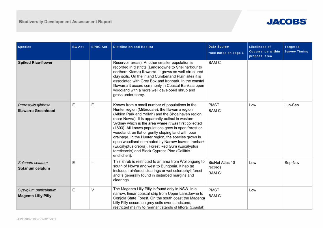
Biodiversity Development Assessment Report
IA193700-0100-BD-RPT-001
Species BC Act EPBC Act Distribution and Habitat Data Source
*see notes on page 1
Likelihood ofOccurrence withinproposal area
TargetedSurvey Timing
Spiked Rice-flower Reservoir areas). Another smaller population isrecorded in districts (Landsdowne to Shellharbour tonorthern Kiama) Illawarra. It grows on well-structuredclay soils. On the inland Cumberland Plain sites it isassociated with Grey Box and Ironbark. In the coastalIllawarra it occurs commonly in Coastal Banksia openwoodland with a more well developed shrub andgrass understorey.
BAM C
Pterostylis gibbosaIllawarra Greenhood
E E Known from a small number of populations in theHunter region (Milbrodale), the Illawarra region(Albion Park and Yallah) and the Shoalhaven region(near Nowra). It is apparently extinct in westernSydney which is the area where it was first collected(1803). All known populations grow in open forest orwoodland, on flat or gently sloping land with poordrainage. In the Hunter region, the species grows inopen woodland dominated by Narrow-leaved Ironbark(Eucalyptus crebra), Forest Red Gum (Eucalyptustereticornis) and Black Cypress Pine (Callitrisendlicheri).
PMSTBAM C
Low Jun-Sep
Solanum celatumSolanum celatum
E - This shrub is restricted to an area from Wollongong tosouth of Nowra and west to Bungonia. It habitatincludes rainforest clearings or wet sclerophyll forestand is generally found in disturbed margins andclearings.
BioNet Atlas 10recordsBAM C
Low Sep-Nov
Syzygium paniculatumMagenta Lilly Pilly
E V The Magenta Lilly Pilly is found only in NSW, in anarrow, linear coastal strip from Upper Lansdowne toConjola State Forest. On the south coast the MagentaLilly Pilly occurs on grey soils over sandstone,restricted mainly to remnant stands of littoral (coastal)
PMSTBAM C
Low

Biodiversity Development Assessment Report
IA193700-0100-BD-RPT-001
Species BC Act EPBC Act Distribution and Habitat Data Source
*see notes on page 1
Likelihood ofOccurrence withinproposal area
TargetedSurvey Timing
rainforest. On the central coast Magenta Lilly Pillyoccurs on gravels, sands, silts and clays in riversidegallery rainforests and remnant littoral rainforestcommunities.
Zieria granulataIllawarra Zieria
E E Illawarra Zieria is a bushy shrubs restricted to theIllawarra region primarily in coastal lowlands. Ittypically occupies dry ridges and rocky outcrops onshallow volcanic soils and less frequently found onmoist slopes of the Illawarra escarpment. It grows inassociation with vegetation comprising Melaleucaarmillaris scrub and Eucalyptus tereticornis woodlandand rainforest margins.
BAM C Low Year round
Hibbertia stricta subsp.furcatulaHibbertia stricta subsp.furcatula
E - Known to occur in two populations, one in thesouthern outskirts of Sydney, and one near Nowra onthe mid-South Coast of NSW. Habitat of the SouthernSydney population is broadly dry eucalypt forest andwoodland. This population appears to occur mainly onupper slopes and above the Woronora River gorgeescarpment, at or near the interface between theLucas Heights soil landscape and Hawkesburysandstone. The species usually grows in 'gravellyloam or clay soil in heath under open woodland'.Habitat of the South Coast population is poorlyrecorded, but appears to be dry sclerophyll forest orwoodland associations in sandy soils over sandstone.
BAM C Low Oct-Mar
Acacia bynoeanaBynoe’s Wattle
E V Found in central eastern NSW, from the HunterDistrict south to the Southern Highlands and west tothe Blue Mountains. It has recently been found in theColymea and Parma Creek areas west of Nowra.
PSMT Low Sep-Mar

Biodiversity Development Assessment Report
IA193700-0100-BD-RPT-001
Species BC Act EPBC Act Distribution and Habitat Data Source
*see notes on page 1
Likelihood ofOccurrence withinproposal area
TargetedSurvey Timing
Occurs in heath or dry sclerophyll forest on sandysoils. Seems to prefer open, sometimes slightlydisturbed sites such as trail margins, edges ofroadside spoil mounds and in recently burnt patches.Associated overstorey species include RedBloodwood (Corymbia gummifera), Scribbly Gum(Eucalyptus haemastoma), Drooping Red Gum (E.parramattensis), Old Man Banksia (Banksia serrata)and Small-leaved Apple (Angophora bakeri).
Boronia deanei V V There are scattered populations of Deane's Boroniabetween the far south-east of NSW and the BlueMountains (including the upper Kangaroo River nearCarrington Falls, the Endrick River near Nerriga andNalbaugh Plateau), mainly in conservation reserves.Wildfires have depleted some populations.
PMST Low
Asterolasia elegans E E Occurs north of Sydney, in the Baulkham Hills,Hawkesbury and Hornsby local government areas.Also likely to occur in the western part of Gosfordlocal government area. Known from only sevenpopulations, only one of which is wholly within aconservation reserve. Occurs on Hawkesburysandstone. Found in sheltered forests on mid- tolower slopes and valleys, e.g. in or adjacent to gullieswhich support sheltered forest. The canopy at knownsites includes Turpentine (Syncarpia glomuliferasubsp. glomulifera), Smooth-barked Apple(Angophora costata), Sydney Peppermint (Eucalyptuspiperita), Forest Oak (Allocasuarina torulosa) andChristmas Bush (Ceratopetalum gummiferum).
PMST Low
Caladenia tessellate E V Known from the Sydney area (old records), Wyong,Ulladulla and Braidwood in NSW. Populations in
PMST Low
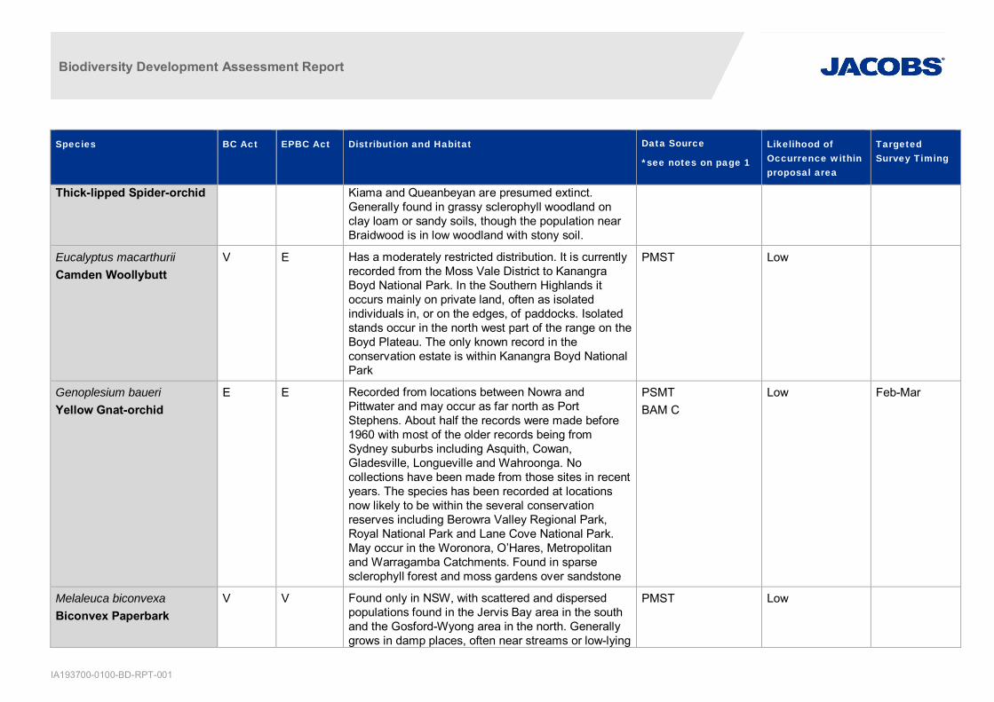
Biodiversity Development Assessment Report
IA193700-0100-BD-RPT-001
Species BC Act EPBC Act Distribution and Habitat Data Source
*see notes on page 1
Likelihood ofOccurrence withinproposal area
TargetedSurvey Timing
Thick-lipped Spider-orchid Kiama and Queanbeyan are presumed extinct.Generally found in grassy sclerophyll woodland onclay loam or sandy soils, though the population nearBraidwood is in low woodland with stony soil.
Eucalyptus macarthuriiCamden Woollybutt
V E Has a moderately restricted distribution. It is currentlyrecorded from the Moss Vale District to KanangraBoyd National Park. In the Southern Highlands itoccurs mainly on private land, often as isolatedindividuals in, or on the edges, of paddocks. Isolatedstands occur in the north west part of the range on theBoyd Plateau. The only known record in theconservation estate is within Kanangra Boyd NationalPark
PMST Low
Genoplesium baueriYellow Gnat-orchid
E E Recorded from locations between Nowra andPittwater and may occur as far north as PortStephens. About half the records were made before1960 with most of the older records being fromSydney suburbs including Asquith, Cowan,Gladesville, Longueville and Wahroonga. Nocollections have been made from those sites in recentyears. The species has been recorded at locationsnow likely to be within the several conservationreserves including Berowra Valley Regional Park,Royal National Park and Lane Cove National Park.May occur in the Woronora, O’Hares, Metropolitanand Warragamba Catchments. Found in sparsesclerophyll forest and moss gardens over sandstone
PSMTBAM C
Low Feb-Mar
Melaleuca biconvexaBiconvex Paperbark
V V Found only in NSW, with scattered and dispersedpopulations found in the Jervis Bay area in the southand the Gosford-Wyong area in the north. Generallygrows in damp places, often near streams or low-lying
PMST Low

Biodiversity Development Assessment Report
IA193700-0100-BD-RPT-001
Species BC Act EPBC Act Distribution and Habitat Data Source
*see notes on page 1
Likelihood ofOccurrence withinproposal area
TargetedSurvey Timing
areas on alluvial soils of low slopes or shelteredaspects.
Melaleuca deaneiDeane’s Melaleuca
V V Deane’s Paperbark occurs in two distinct areas, in theKu-ring-gai, Berowra, Holsworthy and Wedderburnareas, and there are also more isolated occurrencesat Springwood, Wollemi National Park, Yalwal and theCentral Coast areas. The species grows in heath onsandstone
PMST Low
Pelargonium sp. StriatellumOmeo Stork’s-bill
E E Known from only 3 locations in NSW, with two onlake-beds on the basalt plains of the Monaro and oneat Lake Bathurst. A population at a fourth known siteon the Monaro has not been seen in recent years.The only other known population is at Lake Omeo,Victoria. It occurs at altitudes between 680 to 1030 m.It is known to occur in the local government areas ofGoulburn-Mulwaree, Cooma-Monaro, and SnowyRiver, but may occur in other areas with suitablehabitat; these may include Bombala, Eurobodalla,Palerang, Tumbarumba, Tumut, Upper Lachlan, andYass Valley local government areas. It has a narrowhabitat that is usually just above the high-water levelof irregularly inundated or ephemeral lakes, in thetransition zone between surrounding grasslands orpasture and the wetland or aquatic communities. Itsometimes colonises exposed lake beds during dryperiods.
PMST Low
Persoonia glaucescensMittagong Geebung
E V The Mittagong Geebung's historical distributionplaces the northern and eastern limit at Couridjah(Thirlmere Lakes), the southern limit at Fitzroy Fallsand the western limit at High Range. However, recentsurveys have indicated that the species no longer
PMST Low
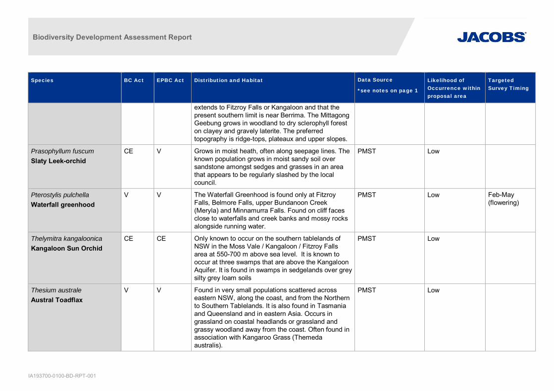
Biodiversity Development Assessment Report
IA193700-0100-BD-RPT-001
Species BC Act EPBC Act Distribution and Habitat Data Source
*see notes on page 1
Likelihood ofOccurrence withinproposal area
TargetedSurvey Timing
extends to Fitzroy Falls or Kangaloon and that thepresent southern limit is near Berrima. The MittagongGeebung grows in woodland to dry sclerophyll foreston clayey and gravely laterite. The preferredtopography is ridge-tops, plateaux and upper slopes.
Prasophyllum fuscumSlaty Leek-orchid
CE V Grows in moist heath, often along seepage lines. Theknown population grows in moist sandy soil oversandstone amongst sedges and grasses in an areathat appears to be regularly slashed by the localcouncil.
PMST Low
Pterostylis pulchellaWaterfall greenhood
V V The Waterfall Greenhood is found only at FitzroyFalls, Belmore Falls, upper Bundanoon Creek(Meryla) and Minnamurra Falls. Found on cliff facesclose to waterfalls and creek banks and mossy rocksalongside running water.
PMST Low Feb-May(flowering)
Thelymitra kangaloonicaKangaloon Sun Orchid
CE CE Only known to occur on the southern tablelands ofNSW in the Moss Vale / Kangaloon / Fitzroy Fallsarea at 550-700 m above sea level. It is known tooccur at three swamps that are above the KangaloonAquifer. It is found in swamps in sedgelands over greysilty grey loam soils
PMST Low
Thesium australeAustral Toadflax
V V Found in very small populations scattered acrosseastern NSW, along the coast, and from the Northernto Southern Tablelands. It is also found in Tasmaniaand Queensland and in eastern Asia. Occurs ingrassland on coastal headlands or grassland andgrassy woodland away from the coast. Often found inassociation with Kangaroo Grass (Themedaaustralis).
PMST Low

Biodiversity Development Assessment Report
IA193700-0100-BD-RPT-001
Species BC Act EPBC Act Distribution and Habitat Data Source
*see notes on page 1
Likelihood ofOccurrence withinproposal area
TargetedSurvey Timing
Triplarina nowraensisNowra Heath-myrtle
E E There are five known populations of Nowra HeathMyrtle. Three of these form a cluster to the immediatewest of Nowra. A fourth, much smaller population isfound 18km south-west of Nowra in the BoolijongCreek Valley. The fifth population is located north ofthe Shoalhaven River on the plateau aboveBundanon.
PMSTBAM C
Low Year round
Xerochrysum palustreSwamp Everlasting
V V Found in Kosciuszko National Park and the easternescarpment south of Badja. Also found in easternVictoria. Grows in swamps and bogs which are oftendominated by heaths. Also grows at the edges of bogmargins on peaty soils with a cover of shrubs orgrasses.
PMST Low
Pomaderrus cotoneasterCotoneaster Pomaderris
E E Cotoneaster Pomaderris has a very disjunctdistribution, being known from the Nungatta area,northern Kosciuszko National Park (near Tumut), theTantawangalo area in South-East Forests NationalPark and adjoining freehold land, Badgery’s Lookoutnear Tallong, Bungonia State Conservation Area, theYerranderie area, Kanangra-Boyd National Park, theCanyonleigh area and Ettrema Gorge in MortonNational Park. The species has also been recordedalong the Genoa River in Victoria
BioNet Atlas 2records
Low Oct-Nov
Eucalyptus langleyiAlbatross Mallee
V - The main occurrence of the Albatross Mallee is to thesouth-west of Nowra as far as Yarramunmun Creek.A very small population is found to the north of theShoalhaven River in the Bomaderry Creek RegionalPark.
BAM C Low Year round
Callistemon linearifolius V - Recorded from the Georges River to HawkesburyRiver in the Sydney area, and north to the Nelson Bay
BioNet Atlas 1 record Low

Biodiversity Development Assessment Report
IA193700-0100-BD-RPT-001
Species BC Act EPBC Act Distribution and Habitat Data Source
*see notes on page 1
Likelihood ofOccurrence withinproposal area
TargetedSurvey Timing
Netted bottle brush area of NSW. Recorded in 2000 at Coalcliff in thenorthern Illawarra. For the Sydney area, recentrecords are limited to the Hornsby Plateau area nearthe Hawkesbury River. The species was morewidespread in the past, and there are currently only 5-6 populations remaining from the 22 populationshistorically recorded in the Sydney area. Three of theremaining populations are reserved in Ku-ring-gaiChase National Park, Lion Island Nature Reserve andSpectacle Island Nature Reserve. The species hasalso been recorded from Yengo National Park.
Gossia acmenoidesGossia acmenoidespopulation in the SydneyBasin Bioregion south ofthe Georges River
EP - Gossia acmenoides grows in dry rainforest, as well asin subtropical rainforest, on the ranges and coastalplain of eastern Australia from the Illawarra (in thesouth) to Queensland. The population of Gossiaacmenoides in the Sydney Basin Bioregion south ofthe Georges River is found in the local governmentareas of Wollongong, Shellharbour and Kiama. Thereare currently about 30 sites where G. acmenoides isfound, often as single individual plants or as a smallgroup of up to four individuals. There are estimated tobe less than 100 mature G. acmenoides plants in thepopulation.
BAM C Low Not specified