Shire of Wyndham East Kimberley Trails Master · PDF file6.4 Kayaking and non-motorised water...
68
Revised Draft FINAL REPORT | 11 September 2017 Shire of Wyndham East Kimberley Trails Master Plan
Transcript of Shire of Wyndham East Kimberley Trails Master · PDF file6.4 Kayaking and non-motorised water...
Revised Draft FINAL REPORT | 11 September 2017
Shire of Wyndham East Kimberley Trails Master Plan
i SHIRE OF WYNDHAM EAST KIMBERLEY | TRAILS MASTER PLAN | 11 September, 2017
Acknowledgements
The Wyndham East Kimberley Trails Master Plan has been prepared by TRC
Tourism Pty Ltd (www.trctourism.com) for the Shire of Wyndham East
Kimberley.
Authors: Chris Halstead, Janet Mackay.
Disclaimer
Any representation, statement, opinion or advice, expressed or implied in this
document is made in good faith but on the basis that TRC Tourism is not liable
to any person for any damage or loss whatsoever which has occurred or may
occur in relation to that person taking or not taking action in respect of any
representation, statement or advice referred to in this document.

ii SHIRE OF WYNDHAM EAST KIMBERLEY | TRAILS MASTER PLAN | 11 September, 2017
Contents Executive Summary IV
1 Introduction 1
1.1 Purpose of the Master Plan 1
1.2 What are Trails 1
1.3 Trends in Trails Use and Development 3
1.4 Benefits of Trails 3
1.5 State Strategic Trail Blueprint 4
1.6 Trail Classification 5
2 Planning Context 6
2.1 Land Use 6
2.2 Shire Land Use Planning 8
2.3 Economic Development 9
2.4 Tourism Planning 10
3 Demand for Trails 12
3.1 Local Residents 12
3.2 Visitors to the Shire 13
4 Current Situation 15
4.1 Current Trails and Trail Use 15
4.2 Strengths and Challenges 20
4.3 Opportunities 22
5 Vision for the Future 26
5.1 Trail Vision 26
5.2 Guiding Principles 27
6 Proposed Trail Development 29
6.1 Kununurra Lakeside Trails - Lily Creek Lagoon to Diversion Dam via Celebrity Tree Park 30
6.2 Celebrity Tree Park to the Pump House West 34
6.3 Lakeside to Equestrian Park, BMX Skills Park and Mirima National Park Mountain Biking 39
6.4 Kayaking and non-motorised water activity 45
6.5 Wyndham 46
6.6 Lake Argyle, Spillway Creek and Ord River 52
7 Implementation Plan 53

iii SHIRE OF WYNDHAM EAST KIMBERLEY | TRAILS MASTER PLAN | 11 September, 2017
Executive Summary The Shire of Wyndham East Kimberley Trails Master Plan
The Shire of Wyndham East Kimberley initiated a Trails Master Plan to establish a sustainable and strategic
approach to providing recreational trails for the use of residents and visitors in the Shire of Wyndham East
Kimberley, Western Australia.
The purpose of the Trails Master Plan is to:
review the Shire’s existing trails network
provide an evidence based strategic approach for the future development of trails and tracks within
the Shire
provide an evidence based strategic approach for the future development of integrated pathways for
bike and pedestrian uses that links key destinations, open space and residential areas within the
town sites of Kununurra and Wyndham.
The Master Plan aims at consolidation, further development and sustainable management of the walking and
cycling trail network and mountain biking opportunities in and near the population centres of Kununurra and
Wyndham.
Local Strategies and Plans
The Draft Shire of Wyndham East Kimberley Local Planning Strategy aims to:
[enable] the growth and development of tourism and tourism-related opportunities that are
appropriate, sensitive and integrated into the natural landscape
facilitate accessible, safe, walkable town centres that provide environmental, economic, social and
lifestyle opportunities and benefits
preserve the values of natural resources by managing the impacts of land use and development on
the environment
ensure planning decisions value and respect multi-cultural heritage.
The Shire’s Lake Kununurra Foreshore and Aquatic Use Plan, prepared in 2006 and updated in 2011, sets out
plans for the management, conservation, recreational and tourism use of the lake and foreshore and
identified proposals for an extended walking and cycling trail network, the development of bird hides, jetties
and areas for canoes/kayaks and hire and tour facilities.
Existing Use
In the Kununurra area walking, running and cycling occur on town paths in the vicinity of Lily Creek lagoon,
Lake Kununurra and the Kelly’s Knob area and on informal trails in the Lakeside, Packsaddle and Sleeping
Buddha area. The walking trails in the adjacent Mirima National Park appeal to both residents and visitors.
Boating and kayaking occurs in Lily Creek Lagoon, Lake Kununurra and the Upper Ord River.
In the Wyndham area walking trails and lookouts on the Bastion Range provide spectacular views of the
estuary of the five rivers as well as Wyndham Port and the Kimberley landscape. Formed pathways provide a
shared cycling, walking and running experience for locals and visitors between Wyndham and the Port and to
the Six Mile Community. The use of the Port to Wyndham section of this trail is currently limited due to
extensive damage to the trail surface.
iv SHIRE OF WYNDHAM EAST KIMBERLEY | TRAILS MASTER PLAN | 11 September, 2017
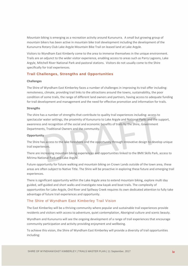
Mountain biking is emerging as a recreation activity around Kununurra. A small but growing group of
mountain bikers has been active in mountain bike trail development including the development of the
Kununurra Rotary Club Lake Argyle Mountain Bike Trail on leased land at Lake Argyle.
Visitors to Wyndham East Kimberly come to the area to immerse themselves in the unique environment.
Trails are an adjunct to the wider visitor experience, enabling access to areas such as Parry Lagoons, Lake
Argyle, Mitchell River National Park and pastoral stations. Visitors do not usually come to the Shire
specifically for trail experiences.
Trail Challenges, Strengths and Opportunities
Challenges
The Shire of Wyndham East Kimberley faces a number of challenges in improving its trail offer including:
remoteness, climate, providing trail links to the attractions around the towns, sustainability, the poor
condition of some trails, the range of different land owners and partners, having access to adequate funding
for trail development and management and the need for effective promotion and information for trails.
Strengths
The shire has a number of strengths that contribute to quality trail experiences including: access to
spectacular water settings, the proximity of Kununurra to Lake Argyle and National Parks and the support,
awareness and recognition of the social and economic benefits of trails by the Shire, Government
Departments, Traditional Owners and the community.
Opportunity
The Shire has access to the lake foreshore and the opportunity through innovative design to develop unique
trail experiences.
There are increasing mountain biking experiences and opportunities linked to the BMX Skills Park, access to
Mirima National Park and Lake Argyle.
Future opportunity for future walking and mountain biking on Crown Lands outside of the town area, these
areas are often subject to Native Title. The Shire will be proactive in exploring these future and emerging trail
experiences.
There is significant opportunity within the Lake Argyle area to extend mountain biking, explore multi day
guided, self-guided and short walks and investigate new kayak and boat trails. The complexity of
opportunities for Lake Argyle, Ord River and Spillway Creek requires its own dedicated attention to fully take
advantage of future trail experiences and opportunity.
The Shire of Wyndham East Kimberley Trail Vision
The East Kimberley will be a thriving community where popular and sustainable trail experiences provide
residents and visitors with access to adventure, quiet contemplation, Aboriginal culture and scenic beauty.
Wyndham and Kununurra will see the ongoing development of a range of trail experiences that encourage
community participation and activity providing enjoyment and wellbeing.
To achieve this vision, the Shire of Wyndham East Kimberley will provide a diversity of trail opportunities
including:

v SHIRE OF WYNDHAM EAST KIMBERLEY | TRAILS MASTER PLAN | 11 September, 2017
distinctive short trails that showcase the Kununurra and Wyndham landscape and waterside
environment to visitors through easily accessible and sustainable trails
trails that encourage the community to get out and enjoy the Kimberley lifestyle while improving
fitness and wellbeing
a hub for sustainable mountain biking including skill development and a variety of trails to challenge
a range of abilities
trails that encourage use and provide safe, sociable and well used linkages between communities,
services and activity
promoting and fostering a range of remarkable adventure trails across the Kimberley.
Shire of Wyndham East Kimberley Proposed Trail Development
Celebrity Tree Park to Lakeside Footbridge
The Celebrity Tree Park and its broad grassed areas provide a pleasant open area for unstructured walking
and play beneath the shade trees. To the north east of the park the trail runs close to the highway with heavy
traffic on one side and a steep eroded slope to Lily Creek Lagoon on the other causing concern and risk to
trail users.
The trail experience can be improved through the development of a raised platform along the shoreline and a
wetland boardwalk on the waters of Lily Creek Lagoon.
The shoreline area and the flat grassed area that adjoins the lagoon in front of the town provide an ideal
launching and retrieval site for kayaks and non-motorised craft. The development of the kayak launching and
retrieval area would relieve pressure and potential conflicts between users at the Old Darwin Road Boat
Ramp
The open ground adjacent to the Highway surrounding the significant boab tree (proposed site for a
Kununurra Welcome and Visitor Centre) provides an ideal site for a future Trail Head, the hub for Kununurra
Trails.
There is a history of antisocial behaviour around the Lakeside Footbridge. A new section of shared use trail
proposed to link to the footbridge should be placed where the Highway will be in view and trail users can be
seen from the Highway. There should also be clear sight lines along the trail with the trail edges not obscured
by vegetation to assist with trail users safety and wellbeing.
Celebrity Tree Park to the Pump House West
From the Celebrity Tree Park it is proposed to develop a trail along the water frontage and through the
bushland of the Kununurra Water Reserve to the significant wetlands of the Lily Creek Lagoon via a wetland
boardwalk with decking areas and kayak landings.
Beyond the wetland the trail passes through shaded bushland to join the shore of Lake Kununurra and a
small creek crossing on a short boardwalk and then to Lakeview Drive. The trail then follows the road side to
the Pump House and from there on the raised levee bank to the Swim Beach, the Diversion Dam and to link
up with the Highway shared path.
A significant part of this trail is situated on the Kununurra Water Reserve and on areas subject to inundation
which adds to the trails attraction. To make this trail environmentally sustainable, low maintenance and have
no impact on water quality it is recommended the trail within the water reserve be of a raised
platform/boardwalk design constructed off site of reinforced concrete or similar and assembled on site.

vi SHIRE OF WYNDHAM EAST KIMBERLEY | TRAILS MASTER PLAN | 11 September, 2017
Lakeside to Equestrian Park, BMX Skills Park and Mirima National Park
Mountain Biking
Water access is an important theme in the development of trail opportunities in Kununurra. It is proposed to
develop a trail circuit around the Lakeside residential area on the Lagoon edge with a significant feature
being a wetland boardwalk across the lagoon creek on the western shore of Lakeside.
The wetland boardwalk would provide unique access to Lily Creek Lagoon through a looped walking
experience whilst also providing shared use access to the Old Darwin Road thus providing year round access
to the BMX Skills Park and other attractions to the south of Lakeside.
There is a commitment from the small but enthusiastic Kununurra mountain bike community to develop
trails in the Mirima National Park. The proposal has in principle the support of the Department Biodiversity,
Conservation and Attractions, Parks and Wildlife Service subject to environmental, social and cultural
heritage assessment.
Mountain biking and other recreational trail access to Mirima National Park from Lakeside and trails linked to
the BMX Skills Park south of Lakeside are proposed. The BMX facility would greatly benefit from safe off
road/Highway trail access from Kununurra.
Kayaking and Non-motorised Water Activity
Lake Kununurra, Lily Creek Lagoon and the associated wetlands provide excellent sheltered water for
canoeing, kayaking and other activities such as stand up paddle boarding.
The development of defined kayak trails is not recommended however it is important that Information for
visitors on locations and kayaking routes is coordinated and provided through visitor centres and information
outlets. Information on smart phones and on signs at launching sites would provide visitors and locals with
the directions and information on how to enjoy the waterways.
The Ord River overnight kayak trail is an iconic experience which can only develop over time. This experience
has the potential to be marketed as a future trail of State Significance. This experience needs to be assessed
in the future linked to Lake Argyle trail and visitor experiences that require specific planning.
Wyndham
The two Bastion trails that link to the Five Rivers Lookout on the Bastion provide great views and an
interesting walking experience and should be retained. The trails need upgrading together with
improvements to the lower car park including restoration and revegetation to make the area more
welcoming. Trail head signs and way marker posts will improve the trail experience and ensure people don’t
lose their way and enjoy the views without having to look at their feet to avoid tripping.
The repair of the Wyndham Port Path is recommended due to its importance to the local community and
further analysis of sustainability surface options needs to be undertaken.
Maintenance of the Six Mile Community Trail is required and recommended together with the replacement
of the damaged river crossing.
Further community interest needs to be developed in providing maintenance and stewardship of the trails
and further exploration of community interest is required prior to any downhill mountain bike trail on the
Bastion.
vii SHIRE OF WYNDHAM EAST KIMBERLEY | TRAILS MASTER PLAN | 11 September, 2017
Lake Argyle, Spillway Creek and Ord River
Lake Argyle is Western Australia's largest and Australia's second largest freshwater man-made reservoir by
volume. The Lake, Ord River, Spillway Creek and the surrounding remote ranges provide the ideal setting for
trail based experiences. The area is utilised for walking, water sports, guided overnight walking, mountain
biking and for endurance events such as the Lake Argyle Adventure Race, an annual swim, paddle, run and
mountain biking race.
Mountain biking takes place on the Rotary Lake Argyle Mountain Bike Track, a 4.95 km moderate grade track
overlooking the lake.
Guided wilderness walking take place in the ranges that surround Lake Argyle and guided kayak trips take
place from the dam wall to Kununurra.
Many people access the Spillway Creek for walking and fishing both on foot and by vehicle. The Spillway
Creek Visitor Area has been closed for many years due to the perceived significant public risk issues associate
with the high flows around the outlet from Lake Argyle.
The distance and cost of getting to the East Kimberley and Lake Argyle area by visitors from the capital cities
is a constraint on the development of future trail based experiences. There are initiatives being developed to
encourage visitors from the capital cities including direct flights from Melbourne, these are expected to
commence in 2018.
The Lake Argyle area is a popular recreation destination for the residents of the East Kimberley being 70
kilometres from Kununurra.
The development of a range of successful trails on Lake Argyle, around the hills and ranges and on the rivers
outflowing from the Lake requires significant planning and assessment which is beyond the scope of this
plan. It is recommended that further investigation and analysis of recreation tourism and trail opportunities
be undertaken in the near future for Lake Argyle and the surrounding area.

1 SHIRE OF WYNDHAM EAST KIMBERLEY | TRAILS MASTER PLAN | 11 September, 2017
1 Introduction
1.1 Purpose of the Master Plan
This Trails Master Plan provides a strategic approach
for the provision of recreational trails for use by
residents and visitors in the Shire of Wyndham East
Kimberley, Western Australia.
The focus will be to provide strategic advice
regarding the trail experiences and trail alignments
within and around the town sites of Kununurra and
Wyndham. Other trail experiences within the large
geographical area of the Shire are being addressed
through tourism related planning referred to in this
plan and some areas such as Lake Argyle have some
developing trail opportunities that require further
detailed analysis and are beyond the scope of this
plan.
The purpose of the Master Plan is to:
review the Shire’s existing trails network
provide an evidence based strategic approach for the future development of trails and tracks
within the Shire
provide an evidence based strategic approach for the future development of integrated pathways for bike and pedestrian uses that links key destinations, open space and residential areas within the town sites of Kununurra and Wyndham.
The Master Plan aims at consolidation, further
development and sustainable management of the
walking and cycling trail network and mountain
biking opportunities in and near the population
centres of Kununurra and Wyndham to improve the
area’s liveability and outdoor recreation
opportunities at a time of anticipated population
growth. These trail developments will also
contribute to the Shire’s visitor offer and showcasing
of the area’s significant natural heritage, biodiversity
and landscapes.
1TRC 2016. Draft Western Australia Strategic Trails Blueprint
2016 -2021, Draft Report for WA Trails Reference Group, TRC
Australia.
The Trails Master Plan addresses:
The current situation of trails in the Shire of Wyndham East Kimberley
The context, trends and markets in trails in Australia and internationally
The appropriate mix and standard of trail experiences to be provided to meet market needs (both community and visitors)
Current events and opportunities for improvement
Sustainable management, maintenance and partnerships for trail networks
Investment needs and opportunities.
1.2 What are Trails
The Draft Western Australia Strategic Trails Blueprint
(shortly to be released) defines trails as pathways or
routes that are developed and/or used for
commuting and travel, recreation, tourism and
appreciation of natural and cultural values.
Trails may be:
short or long, on land or water
part of a trail network or a single journey
used for one activity or shared by several different uses
primarily used by local residents or form a visitor
attraction
purpose-built paths or routes designated by signage and information.
Many trails are developed as local community
infrastructure and as a visitor experience with
associated products, services, accommodation and
interpretation (TRC 2016)1.

2 SHIRE OF WYNDHAM EAST KIMBERLEY | TRAILS MASTER PLAN | 11 September, 2017
Image 1. Kimberley Wet Season at The Grotto off the Great Northern Highway Image1: Kimberley Wet Season at The Grotto off the Great Northern Highway
3 SHIRE OF WYNDHAM EAST KIMBERLEY | TRAILS MASTER PLAN | 11 September, 2017
1.3 Trends in Trails Use and
Development
There has been a global increase in the
development, use and demand for trails reflecting
growth and change in participation in outdoor
activity and the trend to experience-based tourism
in which visitors seek more immersive and
authentic ways to experience people and places.
World-wide the development and use of trails for
local leisure activities and tourism has been
expanding. Trails are now an integral part of the
lifestyle of many communities and of many tourism
destinations.
Walking and bushwalking as ways of experiencing
natural environments have been joined by
mountain biking, horse riding and trail running, and
the emerging trend of riding electric bikes. The
growth of paddling and underwater sports has led
to demand for water-based trail facilities, while the
popularity of four-wheel driving and off-road trail
biking has resulted in development of trails and
routes for these activities. Trails also provide ways
to experience and interpret cultural features in
addition to the natural environment. Art and
culture trails inspire the trail user through a
progression of art works or cultural features that
link to landscape, culture, history or people and can
significantly add value to the trail experience.
Many of these new activities have a strong lifestyle
and/or adventure focus and have motivated
supporters who are closely involved in the
development and maintenance of trails and trail
events. The provision of well-constructed trails is
vital to ensure that these activities are undertaken
in a way that protects natural and cultural values
and is environmentally and socially sustainable over
the long term whilst offering excellent experiences
for participants. Consumers are increasingly
seeking trails that facilitate their overall enjoyment
and appreciation of an area and now expect trails to
provide ‘total experiences’ through the provision of
supporting services, visitor products, interpretation
2 TRC 2016. Draft Western Australia Strategic Trails Blueprint
2016 -2021, Draft Report for WA Trails Reference Group,
TRC Australia
and accessible information. The growth in the
range of people seeking support to explore natural
areas (including growth in the retiree generation)
has resulted in development of ‘soft adventure’
trails and guided or self-guided experience packages
that provide information, accommodation,
transport and equipment.
People are also using digital technologies (such as
smartphones and apps) and social media to access
information about trails and record their trail
activities. There are increasing expectations for
delivery of trail interpretation through digital
sources.
1.4 Benefits of Trails
Globally the provision of trails has been shown to
lead to multiple health, lifestyle, social and economic
benefits for communities, including:
encouraging more outdoor physical activity leading to improved physical and mental wellbeing
improved lifestyle opportunities
low cost facilities for recreation accessible to many different groups in the community
improved awareness of and appreciation of the natural environment and support for its
protection
economic benefits from employment and business opportunities in trail development, management, maintenance, events and supporting products and services
tourism growth to trail destinations with resulting economic stimulus of local economies
protection and showcasing of natural, cultural and historic areas by providing sustainable access
improved sustainability of local communities by making them more attractive places to live
opportunities for social interaction and development of community identity through participation in trail activities, maintenance and
conservation2.
4 SHIRE OF WYNDHAM EAST KIMBERLEY | TRAILS MASTER PLAN | 11 September, 2017
1.5 State Strategic Trail Blueprint
The Wyndham East Kimberley Trails Master Plan fits
within a State-wide planning structure which guides
consistent planning, development and management
of trails throughout the State through:
the Western Australian Strategic Trails Blueprint 2017-2021 (in preparation) which provides broad principles, guidelines and strategies for trail planning, development and management
State-wide Activity-Based Trail strategies – to date for cycling, mountain biking, equestrian and trail bike riding activities
regional trails master plans and localised trail plans.
Key strategies in the Blueprint are:
effective governance to coordinate and facilitate trail development, management and
promotion among the range of stakeholders
consistent and collaborative planning at the state, local and regional levels
sustainable trail design and maintenance
a sound knowledge base to assess trail demand, use and impacts; inform management and enable adaptation to changes over time
community engagement to encourage community stewardship for trails and participation in management
investment and financing sources to support trail development, management and
maintenance
building greater trail use and awareness through improved facilities, interpretation,
events, promotion and marketing
growing the visitor economy through high quality trail experiences that attract visitors and contribute to business and local economic development.
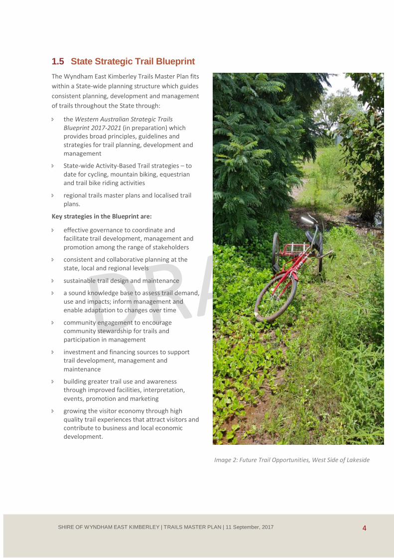
Image 2: Future Trail Opportunities, West Side of Lakeside
5 SHIRE OF WYNDHAM EAST KIMBERLEY | TRAILS MASTER PLAN | 11 September, 2017
1.6 Trail Classification
The WA Strategic Trails Blueprint envisages that trails in the State will be classified according to their state,
regional and local significance.
Table 1: Trail Classification
Classification Attributes
State trail An extended trail or trail network that is of sufficient quality and with appropriate facilities, products and services to be recognised beyond the State and to attract visitors to WA.
Significant intrastate and interstate (and some international) visitation, interest and appeal.
Showcases the State’s significant natural and cultural landscapes.
High standard of management and promotion.
Government priority support at the state and regional level.
Some trails of State significance have the potential to be developed as world-class trail experiences uniquely representative of Australia’s natural and cultural landscape values and attracting international visitation. Such trails (for example Tasmania’s Overland Track and Victoria’s Great Ocean Walk) are destinations in their own right. They have a high standard of infrastructure and facilities and are supported by high-yield tourism products, accommodation and services.
Regional trail A major trail or trail network that services a population centre or large regional community, with facilities and services of a standard and appeal that could attract visitors from outside the region.
Quality infrastructure and facilities appropriate to the type of trail and use.
Supported by viable trail-based and associated regional tourism facilities, products
and services.
Representative of a region’s natural and cultural landscape values.
Well managed and promoted.
Regional government priority support.
Local trails A trail or trail network that services the local community and provides facilities suited to local use.
May also be used by visitors.
Infrastructure, facilities, services and programs appropriate to the type of trail and use.
Some local trails may have potential for development to regional status.
6 SHIRE OF WYNDHAM EAST KIMBERLEY | TRAILS MASTER PLAN | 11 September, 2017
2 Planning Context
2.1 Land Use
2.1.1 Overview
The Shire of Wyndham East Kimberley covers an area
of 121,000 square kilometres in the far north of
Western Australia. The area has a tropical savanna
climate with distinct wet and dry seasons. Most of the
rainfall occurs in the wet season from November to
February when maximum temperatures exceed 40oC
and heavy rainfall events are common. In the dry
season from April to October average maximum
temperatures range from the low to mid 30s with
night time temperatures falling to between 15oC and
20oC.
The main towns in the Shire are Kununurra, the Shire’s
main town developed to service the Ord River
Scheme, and Wyndham, the region’s historic port
town. Kununurra is the community, transport,
industrial and commercial service centre and operates
as a tourism gateway to the Kimberley (due to its
strategic location on the major highway between
Western Australia (WA) and the Northern Territory)
and a centre for visiting the surrounding areas.
Near Kununurra there are irrigated agricultural areas
associated with the damming of the Ord River to
create Lake Argyle. Inland there are large pastoral
leases, some of which have diversified to support
activities such as Aboriginal land management and
tourism enterprises. Large parts of the Shire in the
north and west are Aboriginal land and conservation
reserves. Many of these areas are remote and
accessible only by 4WD vehicle, sea or air.
Parts of the Shire, including the areas in and around
Kununurra and Wyndham, are subject to multiple land
tenure and land and water management
arrangements. Tenures include freehold, Crown and
Government land and native title. Land and water
managers include the Shire of Wyndham East
Kimberley, Department Biodiversity, Conservation and
Attractions, Parks and Wildlife Service, the
Department of Transport (DOT), the Water
Corporation WA and Aboriginal Corporations.
2.1.2 Native Title
Native title has been determined over large areas of
the Shire. The traditional rights and interests of the
native title holders are recognised and protected
under the Native Title Act 1993 and need to be taken
into account in the planning and development
activities including the terms of any applicable
Indigenous Land Use Agreements (ILUA) with native
titleholders. Such an agreement, the Ord Final
Agreement, was concluded with the Yawoorroong
Miriuwung Gajerrong Yirrgeb Noong Dawang
Aboriginal Corporation (MG Corporation) for the
Miriuwung and Gajerrong country around Kununurra
and Lake Argyle.
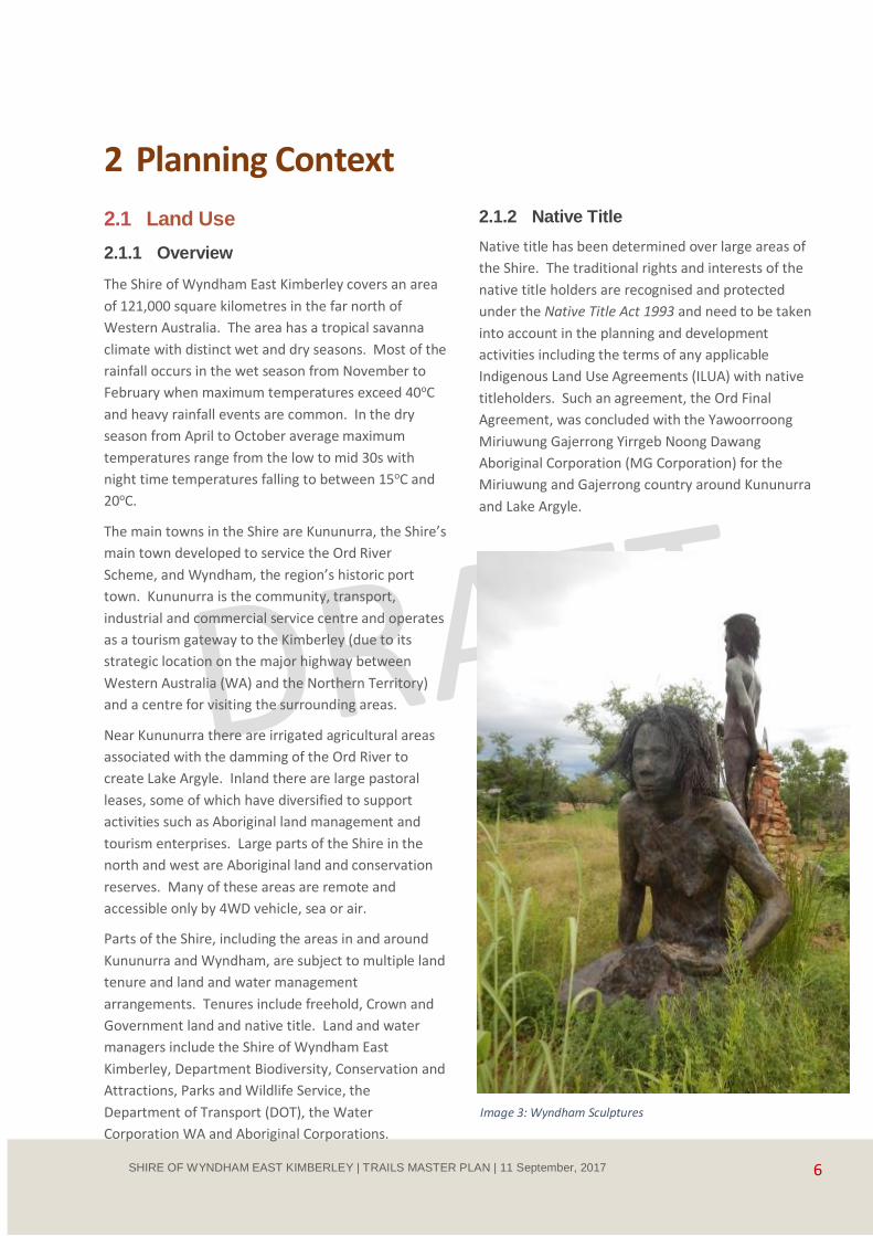
Image 3: Wyndham Sculptures

7 SHIRE OF WYNDHAM EAST KIMBERLEY | TRAILS MASTER PLAN | 11 September, 2017
2.1.3 Conservation Areas
Wyndham East Kimberley has internationally significant terrestrial and marine environmental and biodiversity
values and includes some of the world’s most pristine landscapes and one of the world’s largest wilderness
areas. Lake Argyle, Lake Kununurra and the Ord River Floodplain (near Wyndham) are listed as Wetlands of
International Importance (as habitat for water birds, fish and other species) under the Ramsar Convention.
These Ramsar sites are recognised as matters of national significance under the Commonwealth Government’s
Environment Protection and Biodiversity Conservation Act 1999 (EPBC Act) and developments and activities
with the potential for significant impact on the sites must undergo assessment and approval processes under
that legislation.
The Shire has many conservation reserves declared under the WA Conservation and Land Management Act
1984 including:
Mirima National Park and the Yoorrooyang Dawang Regional Parks near Kununurra
Parry Lagoons Nature Reserve south of Wyndham
remote parks of the north-west Kimberley including Mitchell River National Park, Prince Regent National Park and Drysdale River National Park
existing and proposed marine parks along the coastline.
The area west of Wyndham is also part of the West Kimberley area placed on the National Heritage List under
the EPBC Act for its outstanding natural, cultural, historic and scientific values.
In initiatives stemming from the Kimberley Science and Conservation Strategy, the WA Government has
committed to create a mosaic of national parks. Aboriginal lands, marine areas and some pastoral leases are
also being managed to enhance biodiversity and manage environmental threats.
Traditional Owners are involved in cooperative management of existing and proposed reserves and formal
joint management arrangements are proposed. Yoorrooyang Dawang Regional Parks Reserves near Kununurra
are already being managed under joint management arrangements with the MG Corporation and DBCA.
Image 4: Kayaking and Canoeing Opportunities - Lagoons off Lake Kununurra
8 SHIRE OF WYNDHAM EAST KIMBERLEY | TRAILS MASTER PLAN | 11 September, 2017
2.2 Shire Land Use Planning
The Shire of Wyndham East Kimberley Draft Local Planning Strategy and the associated Draft Shire of
Wyndham East Kimberley Local Planning Scheme No 9, which are in the process of being approved, provide a
guide for future land use and development with implications for the development and location of trails for
local and tourism use. The Draft Local Planning Strategy aims to:
[enable] the growth and development of tourism and tourism-related opportunities that are appropriate,
sensitive and integrated into the natural landscape
facilitate accessible, safe, walkable town centres that provide environmental, economic, social and lifestyle opportunities and benefits
preserve the values of natural resources by managing the impacts of land use and development on the environment
ensure planning decisions value and respect multi-cultural heritage.
Lake Kununurra and the foreshore reserves at Kununurra are an important recreation, conservation and
amenity resource for residents and visitors. Lake Kununurra was formed from the flooding of the Ord River
between the Ord River Dam at Lake Argyle and the Diversion Dam at Kununurra. The foreshore areas are
owned or managed by a variety of agencies including the Shire, the Department of Water, the Water
Corporation, the Department for Regional Development and Lands, the MG Corporation and DBCA. A number
of community organisations and private operators also have leases over portions of the foreshore.
The Shire’s Lake Kununurra Foreshore and Aquatic Use Plan, prepared in 2006 and updated in 2011, sets out
plans for management, conservation, recreational and tourism use of the lake and foreshore. In relation to the
potential for trail development, the Plan includes proposals for an extended walking and cycling trail network,
the development of bird hides, jetties and areas for canoes/kayaks and hire and tour facilities. Delivery of the
Plan’s recommendations is part of the Draft Local Planning Strategy and Local Planning Scheme (see above)
which includes enhanced pedestrian access to the Lake Kununurra Foreshore and provide for passive
recreational and tourism structures (including boardwalks, walking trails, picnic areas) in the area.
In Wyndham the Draft Local Planning Strategy and Scheme propose that detailed planning be undertaken to
facilitate redevelopment of the town site. The foreshore at Anthon Landing, a popular recreation, boating and
fishing site and a historic heritage location, has been improved including the development of community and
tourism facilities based on the recommendations of the Draft Local Planning Strategy. The cycle trail between
the Port and Six Mile requires significant upgrading and maintenance.
The Shire of Wyndham-East Kimberley is considering the future of the leisure and aquatic centre in Kununurra,
which is currently reaching the end of its facility life cycle. The Shire is proactively considering the future
location of leisure facilities and the long-term growth of the town. A business case has been endorsed by Shire
Council which recognises the need to provide ongoing leisure and aquatic facilities whilst developing the most
functional, cost effective and flexible facilities possible. The business case has considered a number of
alternatives for both the type of facilities and the location of facilities. East Lily Creek on the eastern side of
Victoria Highway bounded by Lily Creek and Mirima National Park has been identified as an appropriate
location for future leisure and aquatic facilities in Kununurra. This requires a planning response via structure
plans for the areas known as the Kununurra Civic Precinct and the East Lily Creek area.

9 SHIRE OF WYNDHAM EAST KIMBERLEY | TRAILS MASTER PLAN | 11 September, 2017
The East Lily Creek area identified as an appropriate location for urban development, community centres and
leisure and aquatic facilities provides opportunity for trail linkages and to assist in finding solutions for
pedestrian and cycling crossing of the Victoria Highway sought for mountain biking and other recreational trail
access to Mirima National Park from Lakeside and future trails planned for that area. It is anticipated that
planning for this facility and development will commence in 20183.
2.3 Economic Development
Wyndham East Kimberley is expected to experience economic expansion associated with existing and
proposed economic, infrastructure and community planning investment and initiatives. These initiatives
include agricultural developments under the Ord East Kimberley Expansion Project and Royalties for Regions
funded tourism, housing, recreation facility and transport infrastructure upgrades.
In its 2015 Regional Investment Blueprint for the Kimberley4 the Kimberley Development Commission sets out
strategies for regional economic and services development, improvement of employment and education
opportunities and sustainable communities with a high level of health, amenity and lifestyle advantages that
would attract and retain people in the region. It is envisaged that the scale and quality of community and
recreational facilities in the Shire’s towns and recreation destinations will be improved to accommodate the
needs of this anticipated population growth, as will the design of towns to improve liveability and walkability5.
The Shire of Wyndham East Kimberley Strategic Community Plan 2012-20226 aims to improve lifestyle
opportunities including through development of a well-connected and maintained network of shared paths,
improvement of public parks and increasing access to Lake Kununurra.
3www.swek.wa.gov.au/Assets/Documents/.../Kununurra_Draft_Structure_Plans.pdf 4 Kimberley Development Commission (July 2015), 2036 and Beyond: A Regional Investment Blueprint for the Kimberley 5 Department of Planning and West Australian Planning Commission (December 2015); Kimberley Development Commission (July
2015) 6 Shire of Wyndham East Kimberley (2012), Strategic Community Plan 2012-2022
Image 5: Kununurra Diversion Dam
10 SHIRE OF WYNDHAM EAST KIMBERLEY | TRAILS MASTER PLAN | 11 September, 2017
2.4 Tourism Planning
As a significant contributor to the Shire’s economy,
tourism development is recognised by the Shire and
the Kimberley Development Commission as an
important part of the Shire’s plans for economic
growth.
The East Kimberley Tourism Plan 7 provides
strategies to strengthen the Shire’s tourism sector
and increase tourism yield by 2022 through:
targeting current and potential growth markets
improving air and road access to and around the
Shire
improving quality and standards
developing products, infrastructure, services and events that meet the expectations of target markets, including more water based events, Aboriginal cultural products, and eco-tourism products and experiences. Proposals for the development of new trails and trail-related products in the Cockburn Ranges and Ngamoowalem Conservation Park are mentioned.
7 Kadar Pearson & Partners Pty Ltd (November 2013)
In addition to providing infrastructure that increases
visitor access and experience quality, as tourism
expands infrastructure such as trails and camping
areas will be necessary to minimise visitor impacts
on conservation values and provide for visitor safety
in remote and dangerous environments.
The Shire of Wyndham East Kimberley Draft Local
Planning Strategy No 9 and Local Planning Scheme
includes provision for future tourism development at
Kununurra and Wyndham, Lake Argyle and a number
of other designated tourism nodes throughout the
Shire.
Lake Argyle is a significant destination for local
residents and visitors for sightseeing, land and water
based activities and overnight stays at the Lake
Argyle Resort. There are some bushwalking and
mountain bike trails in the area and remote guided
multiday wilderness walks occur in the ranges
around Lake Argyle. The Draft Local Planning
Strategy and Scheme designates the area as a major
tourism node. It is proposed to facilitate tourism
expansion at Lake Argyle through exploring
enhancement of service provision and reviewing
governance arrangements for infrastructure and
tourism assets.
A major tourism node is proposed for the Drysdale
River Station and minor tourism nodes are proposed
for Mitchell Falls and for Honeymoon Bay near
Kalumburu and the remote Berkley River coastal
resort.
The Kununurra foreshore and waterway directly
support a large part of the local tourism industry.
Visitors to Kununurra often take advantage of
commercial tourism opportunities during their stay.
These tourism enterprises, such as caravan parks,
tour boat operators and the annual Ord Valley
Muster events all contribute directly to the local
economy and provide local employment.
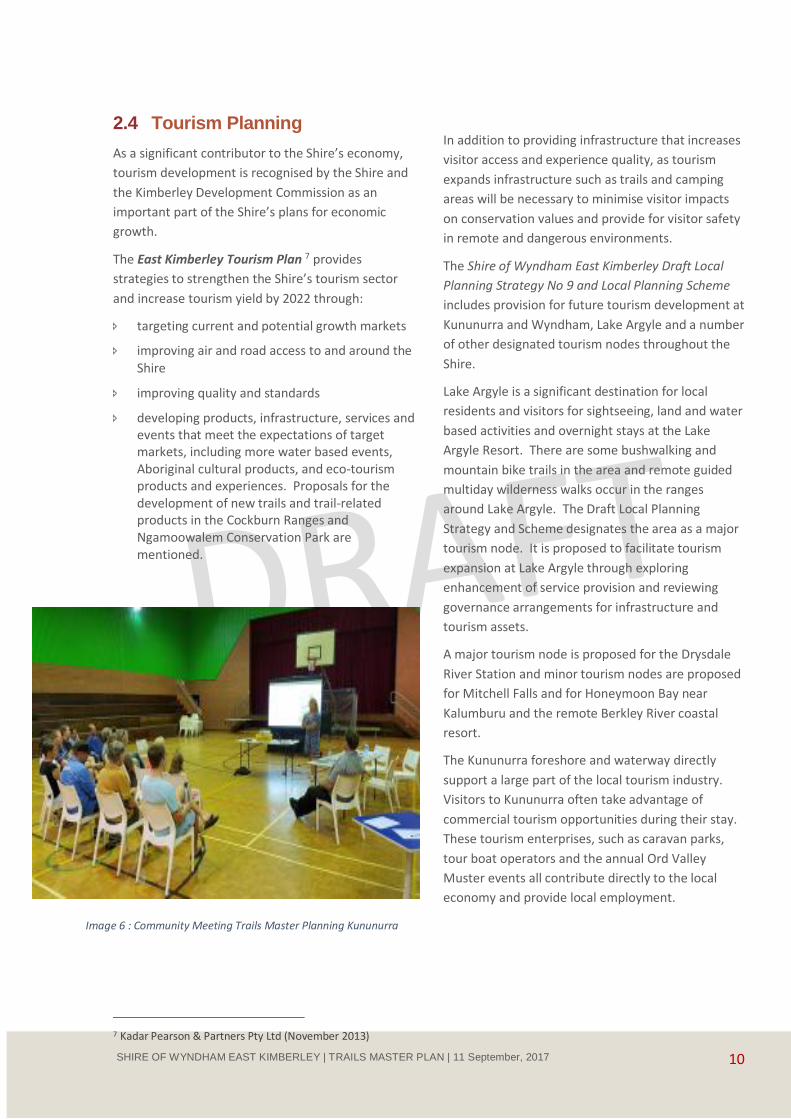
Image 6 : Community Meeting Trails Master Planning Kununurra
11 SHIRE OF WYNDHAM EAST KIMBERLEY | TRAILS MASTER PLAN | 11 September, 2017
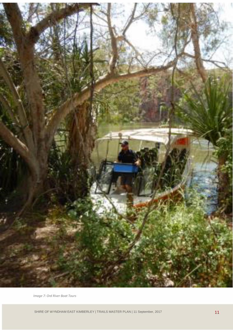
Image 7: Ord River Boat Tours
12 SHIRE OF WYNDHAM EAST KIMBERLEY | TRAILS MASTER PLAN | 11 September, 2017
3 Demand for Trails
3.1 Local Residents
Wyndham East Kimberley had an estimated resident population of 8,713 people in 20148. The population is
concentrated in the towns of Kununurra (which had a resident population of 4,573 people in 2011) and
Wyndham (which had 787 people in 2011)9. Aboriginal people comprised 34.8% of the Shire’s population at
the time of the 2011 Census. The Aboriginal population lives in Kununurra and Wyndham and in several
Aboriginal towns and settlements, the largest of which is Kalumburu, which had 467 people in 2011.
The Shire also has a significant transient population made up of short term workers and dry season visitors.
Town populations are also boosted temporarily during the wet season when flooding makes it difficult to
access some Aboriginal communities.
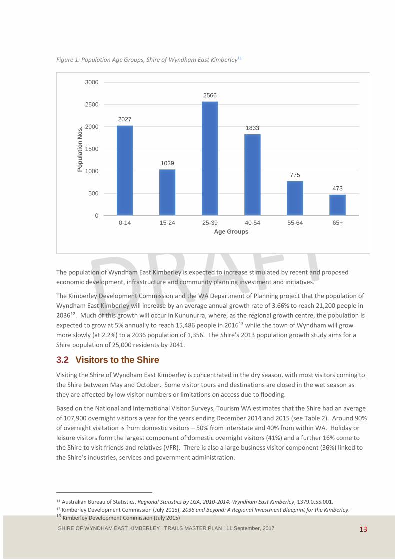
The Shire’s population is younger than the WA average10. In 2014 an estimated 23.2% of the Shire’s residents
were aged 14 years or younger; 12% were aged between 15 and 24; 29.5% between 25 and 39.
8 Australian Bureau of Statistics, Regional Statistics by LGA, 2010-2014: Wyndham East Kimberley, 1379.0.55.001. 9 Department of Planning and West Australian Planning Commission (December 2015), Kimberley Regional Planning and
Infrastructure Framework – Part A: Regional Strategic Planning. 10 MacroPlan Dimasi (November 2013), East Kimberley @ 25K, prepared for the Shire of Wyndham East Kimberley
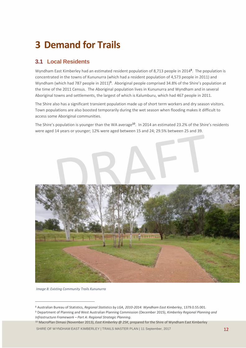
Image 8: Existing Community Trails Kununurra
13 SHIRE OF WYNDHAM EAST KIMBERLEY | TRAILS MASTER PLAN | 11 September, 2017
Figure 1: Population Age Groups, Shire of Wyndham East Kimberley11
The population of Wyndham East Kimberley is expected to increase stimulated by recent and proposed
economic development, infrastructure and community planning investment and initiatives.
The Kimberley Development Commission and the WA Department of Planning project that the population of
Wyndham East Kimberley will increase by an average annual growth rate of 3.66% to reach 21,200 people in
203612. Much of this growth will occur in Kununurra, where, as the regional growth centre, the population is
expected to grow at 5% annually to reach 15,486 people in 201613 while the town of Wyndham will grow
more slowly (at 2.2%) to a 2036 population of 1,356. The Shire’s 2013 population growth study aims for a
Shire population of 25,000 residents by 2041.
3.2 Visitors to the Shire
Visiting the Shire of Wyndham East Kimberley is concentrated in the dry season, with most visitors coming to
the Shire between May and October. Some visitor tours and destinations are closed in the wet season as
they are affected by low visitor numbers or limitations on access due to flooding.
Based on the National and International Visitor Surveys, Tourism WA estimates that the Shire had an average
of 107,900 overnight visitors a year for the years ending December 2014 and 2015 (see Table 2). Around 90%
of overnight visitation is from domestic visitors – 50% from interstate and 40% from within WA. Holiday or
leisure visitors form the largest component of domestic overnight visitors (41%) and a further 16% come to
the Shire to visit friends and relatives (VFR). There is also a large business visitor component (36%) linked to
the Shire’s industries, services and government administration.
11 Australian Bureau of Statistics, Regional Statistics by LGA, 2010-2014: Wyndham East Kimberley, 1379.0.55.001. 12 Kimberley Development Commission (July 2015), 2036 and Beyond: A Regional Investment Blueprint for the Kimberley. 13 Kimberley Development Commission (July 2015)
2027
1039
2566
1833
775
473
0
500
1000
1500
2000
2500
3000
0-14 15-24 25-39 40-54 55-64 65+
Po
pu
lati
on
No
s.
Age Groups
14 SHIRE OF WYNDHAM EAST KIMBERLEY | TRAILS MASTER PLAN | 11 September, 2017
Table 2: Overnight Visitation to Shire of Wyndham East Kimberley, annual average for 2014 and 201514
Visitors Overnight Visitors Purpose of Visit
Nos. % ALOS Holiday Business VFR Other
Intrastate 43,000 40% 8.2 40,000
(41%)
35,000
(36%)
15,500
(16%)
12,000
(12%) Interstate 53,500 50% 8.7
International 11,400 11% No data15 10,200
(90%)
200
(2%)
300
(3%)
800
(7%)
TOTAL 107,900
The main sources of international visitors to the Shire are Europe and the United Kingdom16..
The Shire’s domestic overnight visitors are mainly within the working age groups - 37% of domestic visitors
are aged 25 and 44 years, and 37% are aged between 45 and 64 years. There is also strong visitation from
retired, Grey Nomad visitors. International visitors tend to be somewhat younger than domestic visitors –
19% are aged between 15 and 24 and 37% between 25 and 44.
A large proportion of holiday visitors to Wyndham East Kimberley are on extended drive journeys staying
mainly in caravan and camping accommodation. These include Grey Nomads - a mainstay of visitation to the
Kimberley and north west WA – who travel with self-contained camping equipment, campervans or caravans.
They are either on journeys from the central or eastern States or are Western Australians on trips to escape
the southern winter. There is also some shorter stay visitation for family holidays or short breaks from
nearby regions and the NT. Some holiday visitors fly into Kununurra and hire a car or join tours or cruises.
Business visitors mainly access the Shire by air17..
The Shire also attracts seasonal workers who find work commonly between May to September with citrus,
melons, and tree planting industries and service industries including tourism. The postcode 6743 makes it an
area eligible for backpackers and people wanting to come and travel Australia and to extend their Working
Holiday Visa to an Extended Working Holiday Visa.
The East Kimberley Tourism Plan identifies the following target market segments for Wyndham East
Kimberley based on Tourism WA’s lifestyle-based market segments:
Grey Explorers (or Grey Nomads) – a vital market that needs to be maintained
Dedicated Discoverers – increasing visitation by this a high yielding group that seeks adventure, nature and eco-tourism experiences and requires improved access and products
Business and Corporate – improved provision for existing, and attracting more, short term visitors undertaking work or corporate activities and who require improved local services, access and spare time
activities
Aspirational Achievers – a medium priority, high yielding segment interested in fly/drive, shorter break visits to aspirational destinations and high-end experiences
Family Connectors – a lower priority segment of people living in the region and surrounding areas seeking shorter holiday breaks.
14 Tourism Western Australia (2015), Shire of Wyndham East Kimberley – Overnight Visitor Fact Sheet, Years Ending December
2014/2015. 15 Sample size too small to provide an estimate. 16 Tourism Research Australia (2015), Local Government Area Profiles, 2015 – Wyndham East Kimberley (S), Western Australia. 17 Information sourced from a 2013 visitor survey in Kadar Pearson & Partners Pty Ltd (November 2013), East Kimberley
Tourism Plan 2022, Shire of East Kimberley.
15 SHIRE OF WYNDHAM EAST KIMBERLEY | TRAILS MASTER PLAN | 11 September, 2017
4 Current Situation
4.1 Current Trails and Trail Use
The Shire’s existing trails in and near the main population centres of Kununurra and Wyndham have
developed generally in an ad hoc manner. They are however important to residents for recreation, fitness,
health and wellbeing and ways to access and explore the landscape and its outstanding natural values.
In the Kununurra area walking, running and cycling occur on town paths in the vicinity of Lily Creek lagoon,
Lake Kununurra and the Kelly’s Knob area and on informal trails in the Lakeside, Packsaddle and Sleeping
Buddha area. The walking trails in the adjacent Mirima National Park appeal to both residents and visitors.
Boating and kayaking occurs in Lily Creek Lagoon, Lake Kununurra and the Upper Ord River.
In the Wyndham area walking trails and lookouts on the Bastion Range provide spectacular views of the
estuary of the five rivers as well as Wyndham Port and the Kimberley landscape. Formed pathways provide
a shared cycling, walking and running experience for locals and visitors between Wyndham and the Port
and to the Six Mile Community. The use of the Port to Wyndham section of this trail is currently limited
due to extensive damage to the trail surface.
Mountain biking is emerging as a recreation activity around Kununurra. A small but growing group of
mountain bikers has been active in mountain bike trail development including the development of the
Kununurra Rotary Club Lake Argyle Mountain Bike Trail on leased land at Lake Argyle.
Visitors to Wyndham East Kimberly come to the area to immerse themselves in the unique environment.
Trails are an adjunct to the wider visitor experience, enabling access to areas such as Parry Lagoons, Lake
Argyle, Mitchell River National Park and pastoral stations. Visitors do not usually come to the Shire
specifically for trail experiences.
Other experiences beyond the focus of this Plan include a 2013 proposal to develop a walk in the Cockburn
Ranges to be operated as a guided, fly-in, fly-out 2-night gorge adventure guided by Traditional Owners or
a 4-night independent walk. Some guided walking tours currently appear to access the Cockburn Ranges
gorges.
Other trail experiences within the large geographical area of the Shire are being addressed through tourism
related planning referred to in this plan and some areas such as Lake Argyle have some developing trail
opportunities that require further detailed analysis and are beyond the scope of this plan. This plan will
not be investigating the Lake Argyle trail experiences in detail but recognises the potential for valuable trail
based visitor experiences based on the lake, Ord River and surrounding landscape.
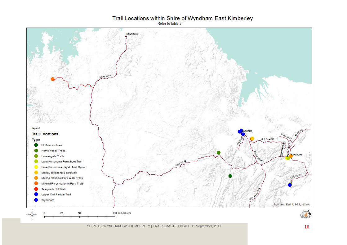
The existing trails in the Shire are summarised in Table 3.
There are a number of trail events held within the Shire:
Lake Argyle Adventure Race
Kununurra Half Marathon
Gibb River Challenge.
16 SHIRE OF WYNDHAM EAST KIMBERLEY | TRAILS MASTER PLAN | 11 September, 2017

17 SHIRE OF WYNDHAM EAST KIMBERLEY | TRAILS MASTER PLAN | 11 September, 2017
Table 3: Existing trails in the Shire of Wyndham East Kimberley
Location Trail Description Condition/Experience
Kununurra Lily Creek Lagoon to Diversion Dam via Celebrity Tree Park
Bitumen shared path parallel to the Victoria Highway. Includes connection to the Levey Bank Pathway – Swim Beach to Pump House.
A network of shared paths has been proposed for Lake Kununurra Foreshore by the Draft Local Planning Strategy and Scheme.
The current network lacks a safe and useable loop for cyclists and walkers as the shared path follows the highway and is subject to inundation. A section of trail near the town is situated with the Highway close on one side and a steep drop to the lake on the other.
Road access is available on Lakeview Drive and Irrigation Channel Road. Lakeview Drive is not safe for cycling or foot traffic as it is narrow with steep drop offs on both sides of the road edge.
The pathways and the trail on the levee bank provide little shade from the sun.
Pathways adjacent to the town link to pleasant walks in the Celebrity Tree Park but in most other areas are close to the highway, which limits the opportunity for quiet lakeside contemplation.
Trails have little or no access to the water and foreshore.
Town to Lakeside Estate via footbridge over Lily Creek and optional highway path over road bridge
Shared use access from the town to the residential area of Lakeside and Lakeside Resort and Caravan Park.
This is popular with locals and is the main pedestrian corridor to the town for shopping and other activities. It is well used during daylight by recreational walkers including dog walkers.
The path is somewhat indistinct on the town side of the bridge. There is evidence of anti-social behaviour seen in broken pedestrian lights on the bridge and approaches and shopping trolleys and rubbish in the creek. Trail users often feel uncomfortable on this section of path particularly after dark.
Kellys Knob Lookout Trail
Access via Kelly Road to the car park and two steep trails to the lookouts and to the communications tower.
Excellent views of the town and Mirima National Park in an area well used by walkers and fitness runners who utilise the steep road way and trails.
Strong community action established public access to the area around the communication tower.
The trail is popular in the morning and afternoon year-round with locals and visitors.
Step work is not attractive but functional.
Various trails south east of Lakeside
A number of informal trails and vehicle tracks are situated along the bushland run out area of Lily Creek and on the old cattle experimental land currently vested with the Shire.
The area is well used by residents of Lakeside and others, but the informal nature of the trails discourages regular use by those not familiar with the site.
Serious erosion is evident due to run off from the new subdivision and the Mirima National Park catchment. The flat and sandy nature of the soil

18 SHIRE OF WYNDHAM EAST KIMBERLEY | TRAILS MASTER PLAN | 11 September, 2017
Location Trail Description Condition/Experience
The area is popular with recreational walkers, dog walkers and mountain bikers.
The proposed East Lily Creek Structure Plan proposes new leisure and community facilities and a highway pedestrian and cycling crossing. The new plan provides links to a new subdivided area and Mirima National Park.
makes for challenging trail construction and maintenance.
Access to the area is not defined through the Lakeview Estate.
The proposed East Lily Creek Structure Plan will provide safe access across Victoria Highway and if planned with trail links will enable mountain biking and walking access to Mirima National Park from Lakeside.
Adjacent to the Ord River Kununurra Race Club and Rodeo Grounds
A recreational precinct is being developed on the banks of the Ord River near the equestrian area including BMX, mountain bike skills park and dragon boat racing
The development by Kimberley Action Sports Inc. of a cycling skills park in this area is an important step in developing mountain biking as a popular sport in Kununurra.
Walking takes place to the hill area referred to as the Sleeping Buddha generally by local people who have access on unmarked trails.
Horse Trail Riding
Guided trail riding is available south of the town adjacent to the Kununurra Race Club.
Lake Kununurra Kayaking and non-motorised water activity
Kayaking and other activities (including stand up paddle boarding) occurs on Lake Kununurra, Lily Creek Lagoon and lagoons off the lake in Darram Conservation Park and upstream of Kununurra Race Club.
Water based activity provides a unique experience and guided tours and hire equipment is provided. Visitors are often not aware of the opportunities available.
Mirima National Park
Gerliwany-gerring Bana Trail
2 km return valley walk through sandstone formations.
Derdbe-gerring Banan Lookout Trail
800 metre return Class 4 (moderate to difficult) walk on a steep trail with views over the Ord Valley and ranges.
Looking at Plants Nature Trail
400 metres interpreted nature trail.
Demboong Bana Gap Trail
500 km return moderate trail with views over Kununurra.
Mirima National Park is an area of 2,067 hectares with spectacular rock formations and abundant wildlife. The park is significant to the Miriwoong people.
The park is 2 km east of Kununurra and is popular for walking, photography and nature observation. It is managed as a day use area.
The park is managed by DBCA in partnership with MG Traditional Owners. There is no approved management plan.
DBCA support the development of mountain biking in the eastern section of the Mirima National Park subject to cultural, heritage and environmental assessment.

19 SHIRE OF WYNDHAM EAST KIMBERLEY | TRAILS MASTER PLAN | 11 September, 2017
Location Trail Description Condition/Experience
Ord River Ord River Paddle Trail
http://trailswa.com.au/trails/ord-river
45 km paddle journey from the Ord River Dam to Kununurra of moderate difficulty and requiring self-reliance.
The three or four day kayaking experience that follows the Ord River from the Lake Argyle dam wall provides a popular regional trail experience.
Lake Argyle Resort Rotary Lake Argyle Mountain Bike Track
4.95 km moderate grade track www.lakeargyle.com/discover-and-experience/mountain-biking
Situated on leased land, the track was built by volunteers from Kimberley Action Sports Inc. with support from Rotary Kununurra, Lake Argyle Resort and Metaland Kununurra.
Wyndham Port Path
Approximately 4.16 km cycle (shared use) path from Wyndham to the Port of Wyndham parallel to the highway.
The use of the path is currently limited due to extensive damage to the trail surface. The path was proposed for upgrading under the Draft Local Planning Strategy and Scheme. Path upgrading options are provided in the report Dual Use Path Improvements, prepared by Blackwell & Associates for SWEK August 2012.
Six Mile Community Trail
Cycle (shared use) 2.5 km path from Wyndham to the Six Mile Community
This trail is used by the community - including the local football club for fitness training. This path is serviceable and is in better condition than the Port Path. The creek crossing at Six Mile is damaged beyond repair.
Walking Trails to the Five Rivers Lookout on The Bastion
Two walking trails loop around the Bastion starting at the quarry car park mid-way (2.6 km) up Hugo Austla Drive.
The trails provide good views of the Five Rivers, the Cambridge Gulf and Kimberley landscape and are an attraction for visitors. The trail routes are obscure due to grass growth and use of rocks as way marking. The trails require maintenance including grade reversal work to reduce erosion and placement of trail head and way marking signs.
Trails from the Three Mile Valley and to Five Rivers Lookout
A short walk to waterholes from the picnic area
A walking trail was established from the valley floor to the Five Rivers Lookout (approx. 3.5 km)
The walking trails are overgrown and difficult to identify. Most users take advantage of the Hugo Austla Drive for exercise.
Other than concrete markers at the start there is little in the way of trail way marking and the trails are overgrown.
Trails Outside of the Study Area or Managed by DBCA
Parry Lagoons Nature Reserve
Marlgu Billabong Boardwalk
Short, wheelchair accessible, interpreted boardwalk and bird hide on the edge of the Ord River floodplain.
Telegraph Hill Walk
800 metre interpreted walk through the foundation of the 1914 wireless
Parry Lagoons Nature Reserve is 80 km north west of Kununurra and 50 km south east of Wyndham.
The reserve is managed in accordance with the Ord River and Parry Lagoons Nature Reserves Management Plans 77, 2012 and in cooperation with Balanggarra and Miriuwung Gajerrong Traditional Owners.

20 SHIRE OF WYNDHAM EAST KIMBERLEY | TRAILS MASTER PLAN | 11 September, 2017
Location Trail Description Condition/Experience
station, with views of the Ord River floodplain and Parry’s Creek.
The Reserve is managed as a day use area with limited visitor facilities and no formal camping facilities. The Ord River Floodplain is a wetland of international significance (for water birds) under the Ramsar Convention.
Mitchell River National Park
Punamii-unpuu/Mitchell Falls Walk
8.6 km return Class 5 walk to spectacular waterfall from Mitchell Falls Campground.
River View Walk
2 km return Class 4 walk.
Aunauyu/ Surveyors Pool Walk
2 km return easy to moderate (Class 4) walk.
Little Mertens Falls Walk
1.6 km return Class 3 walk.
This remote park, situated 500 km north west of Kununurra, is accessible only by 4WD vehicle and by boat or air. Road access may be closed in the wet season.
The park is managed by DBCA cooperatively with the Traditional Owners. There is no approved management plan.
A network of walking trails has been established in the main visitor areas. In addition to park camping facilities there is nearby commercial accommodation. Commercial tour /products offered include fly in and 4WD coach tours, scenic flights.
Private walking trails on pastoral stations and resorts
Examples are:
Lake Argyle Resort (70 km from Kununurra) - www.lakeargyle.com
El Questro Station (110 km from Kununurra) - www.elquestro.com.au
Home Valley Station (120 km from Kununurra) - www.hvstation.com.au
Unofficial Trails in the region
The Shire recognises that there are a number of unauthorised/ unofficial trails within the Kununurra, Wyndham and the surrounding areas. These unauthorised trails are well utilised by various user groups and members of the community without the approval of the land manager/owner. Future consideration to formalise these trails needs to be addressed, this may be done by forming a steering group which could consist of relevant government agencies, land manager/owners, community groups and other relevant stakeholders who could work through numerous issues such as land tenure.
4.2 Strengths and Challenges
The distinctive features of Kununurra are its lagoon and riverine environments and the rugged nature of
the adjacent ranges. Wyndham is steeped in history and the Bastion provides the magnificent views of the
Kimberley and the five rivers estuaries. The distinctive natural assets of the Shire provide unique trail
experiences providing recreational experiences for visitors and locals.
The visitor focus is the broader attractions of the Kimberley, and Kununurra and Wyndham are generally
places that people visit on their way to and from the main attractions. The climatic conditions including hot
summers with monsoonal rainfall and distance from large population centres means that trail activity is
likely to be limited to local people through the year and visitors during the cooler dry season. For most
visitors to the area, it is likely that trails within the study area will contribute to the experience rather than
be the core driver for their visit.
21 SHIRE OF WYNDHAM EAST KIMBERLEY | TRAILS MASTER PLAN | 11 September, 2017
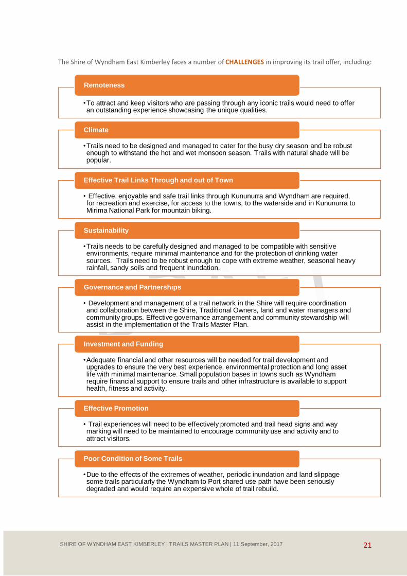
The Shire of Wyndham East Kimberley faces a number of CHALLENGES in improving its trail offer, including:
•To attract and keep visitors who are passing through any iconic trails would need to offer an outstanding experience showcasing the unique qualities.
Remoteness
•Trails need to be designed and managed to cater for the busy dry season and be robust enough to withstand the hot and wet monsoon season. Trails with natural shade will be popular.
Climate
• Effective, enjoyable and safe trail links through Kununurra and Wyndham are required, for recreation and exercise, for access to the towns, to the waterside and in Kununurra to Mirima National Park for mountain biking.
Effective Trail Links Through and out of Town
•Trails needs to be carefully designed and managed to be compatible with sensitive environments, require minimal maintenance and for the protection of drinking water sources. Trails need to be robust enough to cope with extreme weather, seasonal heavy rainfall, sandy soils and frequent inundation.
Sustainability
• Development and management of a trail network in the Shire will require coordination and collaboration between the Shire, Traditional Owners, land and water managers and community groups. Effective governance arrangement and community stewardship will assist in the implementation of the Trails Master Plan.
Governance and Partnerships
•Adequate financial and other resources will be needed for trail development and upgrades to ensure the very best experience, environmental protection and long asset life with minimal maintenance. Small population bases in towns such as Wyndham require financial support to ensure trails and other infrastructure is available to support health, fitness and activity.
Investment and Funding
• Trail experiences will need to be effectively promoted and trail head signs and way marking will need to be maintained to encourage community use and activity and to attract visitors.
Effective Promotion
•Due to the effects of the extremes of weather, periodic inundation and land slippage some trails particularly the Wyndham to Port shared use path have been seriously degraded and would require an expensive whole of trail rebuild.
Poor Condition of Some Trails
22 SHIRE OF WYNDHAM EAST KIMBERLEY | TRAILS MASTER PLAN | 11 September, 2017
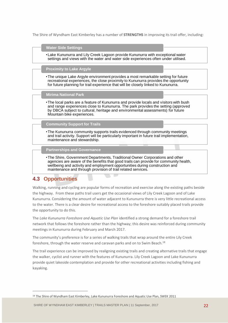
The Shire of Wyndham East Kimberley has a number of STRENGTHS in improving its trail offer, including:
4.3 Opportunities
Walking, running and cycling are popular forms of recreation and exercise along the existing paths beside
the highway. From these paths trail users get the occasional views of Lily Creek Lagoon and of Lake
Kununurra. Considering the amount of water adjacent to Kununurra there is very little recreational access
to the water. There is a clear desire for recreational access to the foreshore suitably placed trails provide
the opportunity to do this.
The Lake Kununurra Foreshore and Aquatic Use Plan identified a strong demand for a foreshore trail
network that follows the foreshore rather than the highway; this desire was reinforced during community
meetings in Kununurra during February and March 2017.
The community’s preference is for a series of walking trails that wrap around the entire Lily Creek
foreshore, through the water reserve and caravan parks and on to Swim Beach.18
The trail experience can be improved by realigning existing trails and creating alternative trails that engage
the walker, cyclist and runner with the features of Kununurra. Lily Creek Lagoon and Lake Kununurra
provide quiet lakeside contemplation and provide for other recreational activities including fishing and
kayaking.
18 The Shire of Wyndham East Kimberley, Lake Kununurra Foreshore and Aquatic Use Plan, SWEK 2011
•Lake Kununurra and Lily Creek Lagoon provide Kununurra with exceptional water settings and views with the water and water side experiences often under utilised.
Water Side Settings
•The unique Lake Argyle environment provides a most remarkable setting for future recreational experiences, the close proximity to Kununurra provides the opportunity for future planning for trail experience that will be closely linked to Kununurra.
Proximity to Lake Argyle
•The local parks are a feature of Kununurra and provide locals and visitors with bush and range experiences close to Kununurra. The park provides the setting (approved by DBCA subject to cultural, heritage and environmental assessments) for future Mountain bike experiences.
Mirima National Park
•The Kununurra community supports trails evidenced through community meetings and trail activity. Support will be particularly important in future trail implementation, maintenance and stewardship.
Community Support for Trails
•The Shire, Government Departments, Traditional Owner Corporations and other agencies are aware of the benefits that good trails can provide for community health, wellbeing and activity and employment opportunities during construction and maintenance and through provision of trail related services.
Partnerships and Governance

23 SHIRE OF WYNDHAM EAST KIMBERLEY | TRAILS MASTER PLAN | 11 September, 2017
To access the foreshore and to ensure a good lakeside experience trail design will need to incorporate an
innovative approach to trail materials, raised decking and walkways that have little impact on the
environment, require little maintenance and are value for money.
The opportunities within the study area include increasing mountain biking experiences linked to the BMX
Skills Park development adjacent to Lake Kununurra, within Mirima National Park and at Lake Argyle.
Further mountain bike opportunities may develop over time driven by the mountain bike community. As
the sport develops this may include a community developed downhill track at the Bastion outside of
Wyndham.
Future opportunity for walking and mountain biking may be found on Crown Lands outside of the town
area, these areas are often subject to Native Title. These areas will not be detailed within this Plan however
it is recommended that the Shire be proactive in exploring these future trail experiences and be engaged
with partner agencies in looking at the benefits of emerging trail opportunities.
On water opportunities include kayaking, stand up paddle boarding and other non-motorised water sports.
The plan recommends the promotion of the kayaking experiences on the lagoon and lake but due to the
numerous opportunities it is recommended that no defined trails be identified but areas and destinations
be promoted through brochures, maps and digital technologies such as Apps.
There are significant opportunities within the Lake Argyle Area including extended mountain biking, further
multi day guided and self-guided walking, short walks, kayak trails and boat trails both on the lake, Ord
River and Spillway Creek. The complexity of opportunities for Lake Argyle requires its own dedicated
attention and should be the focus of future trails and visitor planning.
Table 4: Visitor markets for trails in the Shire of Wyndham East Kimberley
Market Segment
Characteristics Trail Preferences Potential in Shire of Wyndham East Kimberley
LOCAL RESIDENTS
Local Residents People with an interest in outdoor activities for recreation, transport, exploring the natural environment and health and activity.
Recreational and sporting groups including future BMX track and skills park.
Mountain Bikers – a small, but growing group that has been active in trail development at Lake Argyle and in and around Kununurra.
The proposed East Lily Creek Structure Plan with new leisure and community facilities and a highway pedestrian and cycling crossing.
Pedestrian and cycling trails to destinations within towns.
A variety of trails for walking, running, horse-riding, cycling, mountain biking and water-based activities and for weekend and holiday activities in surrounding areas.
Existing
Shared path to Diversion Dam.
Wyndham Port Path.
Mirima National Park trails.
Walking trails at Lake Argyle.
Mountain biking trails at lake Argyle.
Kellys Knob.
Potential
Trails to improve walking and cycling linkages in Kununurra and Wyndham.
Trails around Lakeside and over the water trail link to Old Darwin Road and to skills park and mountain bike sites.
Lily Creek Lagoon and Lake Kununurra foreshore and on water wetland trails.

24 SHIRE OF WYNDHAM EAST KIMBERLEY | TRAILS MASTER PLAN | 11 September, 2017
Market Segment
Characteristics Trail Preferences Potential in Shire of Wyndham East Kimberley
Promotion of kayaking routes and experiences on Lake Kununurra
Development of mountain bike trails around Kununurra including Mirima National Park. Links to future mountain bike trails and to other recreation facilities including the BMX facility and skills park on the lake edge south of Lakeside
VISITORS
Grey Explorers Retired couples aged from around 60 years and over from WA travelling north during the winter or from interstate on extended camping and caravanning trips.
May be on fixed incomes and therefore budget conscious.
Tend to be interested in iconic or well-known destinations such as Lake Argyle, the Gibb River Road, Mitchell Falls
Short and medium length trails for sightseeing and exploring on land and water day trips.
Trails suited for people with limited mobility.
Existing
Mirima National Park and Parry Lagoon trails.
Celebrity Tree Park paths.
Wyndham Bastion short walks.
Lake Argyle bushwalking trails.
Potential
Shared use paths Lily Creek Lagoon and Lake Kununurra foreshore and on water wetland trails.
Promotion of kayaking routes and experiences on Lake Kununurra
Dedicated Discoverers
Domestic and international visitors around 35 to 64 years, though they may be younger.
Fly/drive, drive visitors or tour visitors.
Interested in:
• discovering new places and people
• immersive experiences of nature and culture.
Experiences in the region tend to focus on:
• adventure
• eco-tourism
• Aboriginal cultural experiences
• events.
Iconic day walks or water-based trails showcasing natural and cultural features with interpretation and guided options. Possibly part of eco-tourism or adventure packages or tours.
Soft adventure multi-day trails (on land or water) offering 2 to 4 day experiences with quality self-guided and guided options.
May attend trail events if they have an interest in the specific activities such as mountain biking, kayaking, running and the event provides a unique experience.
May require equipment hire.
Existing
Lake Kununurra Paddle Trail (multi-day experience).
Wyndham Bastion short walks.
Potential
Shared use paths Lily Creek Lagoon and Lake Kununurra foreshore and on water wetland trails.
Promotion of kayaking routes and experiences on Lake Kununurra.
Development of mountain bike trails around Kununurra including Mirima National Park.
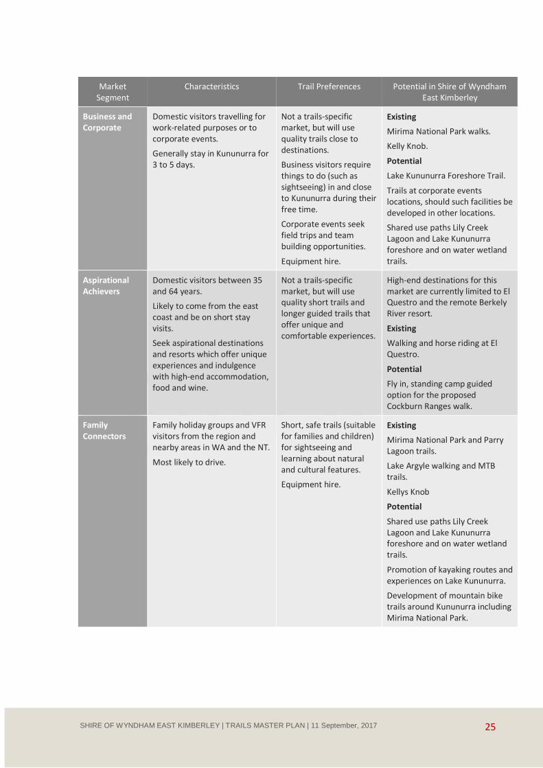
25 SHIRE OF WYNDHAM EAST KIMBERLEY | TRAILS MASTER PLAN | 11 September, 2017
Market Segment
Characteristics Trail Preferences Potential in Shire of Wyndham East Kimberley
Business and Corporate
Domestic visitors travelling for work-related purposes or to corporate events.
Generally stay in Kununurra for 3 to 5 days.
Not a trails-specific market, but will use quality trails close to destinations.
Business visitors require things to do (such as sightseeing) in and close to Kununurra during their free time.
Corporate events seek field trips and team building opportunities.
Equipment hire.
Existing
Mirima National Park walks.
Kelly Knob.
Potential
Lake Kununurra Foreshore Trail.
Trails at corporate events locations, should such facilities be developed in other locations.
Shared use paths Lily Creek Lagoon and Lake Kununurra foreshore and on water wetland trails.
Aspirational Achievers
Domestic visitors between 35 and 64 years.
Likely to come from the east coast and be on short stay visits.
Seek aspirational destinations and resorts which offer unique experiences and indulgence with high-end accommodation, food and wine.
Not a trails-specific market, but will use quality short trails and longer guided trails that offer unique and comfortable experiences.
High-end destinations for this market are currently limited to El Questro and the remote Berkely River resort.
Existing
Walking and horse riding at El Questro.
Potential
Fly in, standing camp guided option for the proposed Cockburn Ranges walk.
Family Connectors
Family holiday groups and VFR visitors from the region and nearby areas in WA and the NT.
Most likely to drive.
Short, safe trails (suitable for families and children) for sightseeing and learning about natural and cultural features.
Equipment hire.
Existing
Mirima National Park and Parry Lagoon trails.
Lake Argyle walking and MTB trails.
Kellys Knob
Potential
Shared use paths Lily Creek Lagoon and Lake Kununurra foreshore and on water wetland trails.
Promotion of kayaking routes and experiences on Lake Kununurra.
Development of mountain bike trails around Kununurra including Mirima National Park.

26 SHIRE OF WYNDHAM EAST KIMBERLEY | TRAILS MASTER PLAN | 11 September, 2017
5 Vision for the Future
5.1 Trail Vision
The East Kimberley will be a thriving
community where popular and
sustainable trail experiences provide
residents and visitors with access to
adventure, quiet contemplation,
Aboriginal culture and scenic beauty.
Wyndham and Kununurra will see the
ongoing development of a range of
trail experiences that encourage
community participation and activity
providing enjoyment and wellbeing.
To achieve this vision, the Shire of Wyndham East
Kimberley will provide a diversity of trail
opportunities including:
distinctive short trails that showcase the Kununurra and Wyndham landscape and waterside environment to visitors through easily accessible and sustainable trails
trails that encourage the community to get out and enjoy the Kimberley lifestyle while improving fitness and wellbeing
a hub for sustainable mountain biking including skill development and a variety of
trails to challenge a range of abilities
trails that encourage use and provide safe, sociable and well used linkages between communities, services and activity
promoting and fostering a range of remarkable
adventure trails across the Kimberley.
Image9 : Wet Season Boab Trees

27 SHIRE OF WYNDHAM EAST KIMBERLEY | TRAILS MASTER PLAN | 11 September, 2017
5.2 Guiding Principles
Delivering the Vision is guided by the following principles.
• A focus on the management and development of trails for a range of recreational pursuits including walking, running, bike riding and kayaking incorporating:
•high quality sustainable trails, trailheads and signage
•consistency in trail standards across tenures
•consistent design principles for sustainable high quality trails
• trail experiences for different skill levels and abilities that encourage community use and activity
•a focus on a small number of outstanding experiences, rather than a larger number of mediocre experiences
• trails that compliment and encourage sustainable tourism activities
High quality, and diverse trail experiences
• Trails will be based on sound, realistic data and assumptions in relation to the long-term financial viability of building, managing and maintaining any trails. Trails development will:
•contribute to environmental protection
•meet the needs of the users
• require little maintenance
•minimise conflict between different user groups
•provide the greatest return to the community, whilst recognising the limited resources available
Sustainability
• Trails will be accessible to local people and visitors through well planned pathway connections and trail heads. Trails will be designed and maintained to encourage use and will be safe for the user. Trails will link to services, visitor facilities, and recreation. Wyndham and Kununurra will be trail friendly communities.
Accessible, safe and well connected trails
• Governance arrangements that facilitate effective collaboration between the multiple land owners, partners and stakeholders will be required for trails.
• Good communication with stakeholders and observation of required approval processes will be important in developing trails and experiences.
Good governance and strong
partnerships
• Trails will encourage social interaction, participation and contribute to improved community physical and mental wellbeing. Trails will provide opportunity for frequent low cost popular outdoor physical activity for all age groups and abilities.
Community benefits
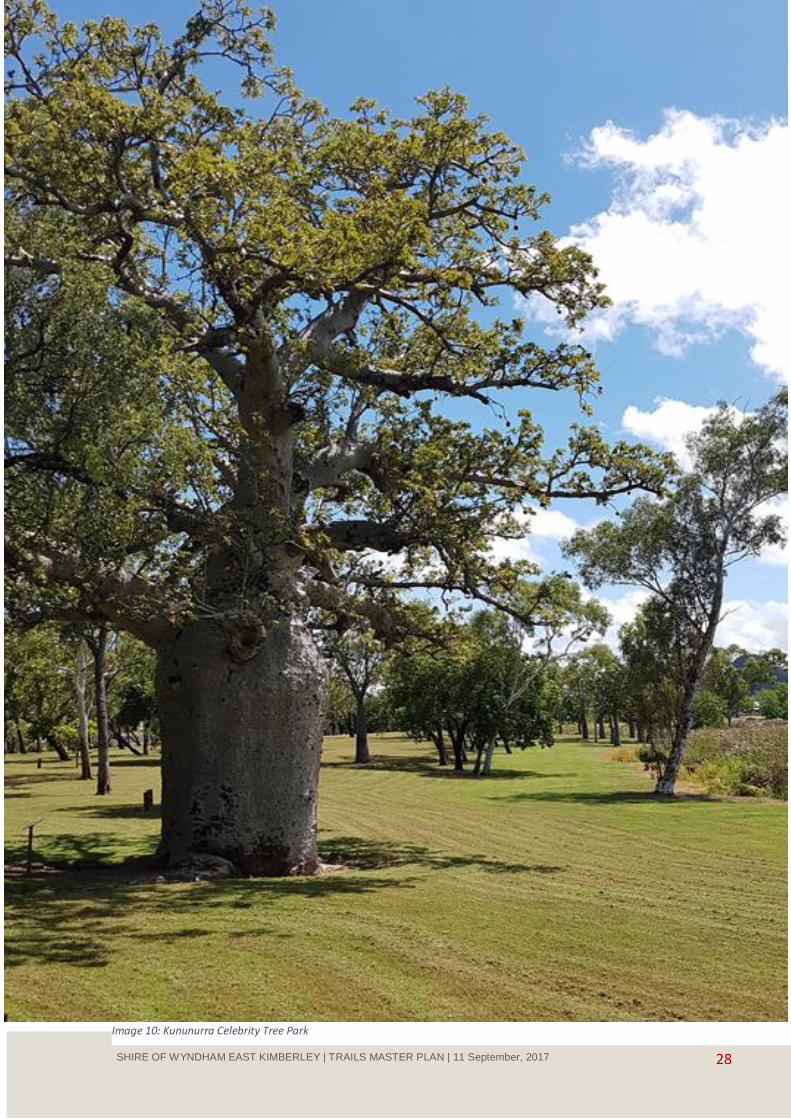
28 SHIRE OF WYNDHAM EAST KIMBERLEY | TRAILS MASTER PLAN | 11 September, 2017
Image 10: Kununurra Celebrity Tree Park
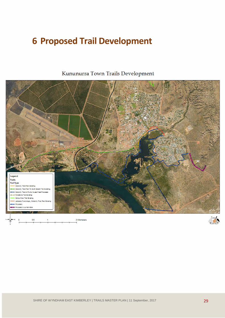
29 SHIRE OF WYNDHAM EAST KIMBERLEY | TRAILS MASTER PLAN | 11 September, 2017
6 Proposed Trail Development
30 SHIRE OF WYNDHAM EAST KIMBERLEY | TRAILS MASTER PLAN | 11 September, 2017
6.1 Kununurra Lakeside Trails - Lily Creek Lagoon to Diversion Dam via
Celebrity Tree Park
Celebrity Tree Park to Lakeside Footbridge
Description
The Celebrity Tree Park and its broad grassed areas provide a pleasant open area for unstructured walking
and play beneath the shade trees. To the north east of the park the trail runs close to the highway with
heavy traffic on one side and a steep eroded slope to Lily Creek Lagoon on the other causing concern and
risk to trail users.
This section of trail is situated on the road reserve managed by Main Roads Western Australia who share the
concern regarding the steep bank and stability and erosion issues. Main Roads are looking at providing
engineering solutions to mitigate the erosion through placement of gabion rock walling or similar. It is
important that any future works are planned with consideration of future trail users and recommendations
from the Trails Master Plan.
The trail experience can be improved through the development of a spur trail leading to a raised platform
along the shoreline and via a boardwalk over the waters of Lily Creek Lagoon and then to join the existing
trail on the grassed area west of the pump shed.
Before the pump shed the existing trail takes a right angle turn to link up to the Highway and the town. The
direction of the trail is good for town access however it is not consistent with the principle of providing a
popular shoreline trail experience and a continuation of a shoreline alignment through the pump area is
proposed. This general area is dominated by bare ground, the pump shed, and drains from the town to the
lagoon.
The shoreline area adjacent to the pump shed and the flat grassed area that adjoins the lagoon provide an
ideal launching and retrieval site for kayaks and non-motorised craft. Infrastructure required would include
formalising and hardening of the car park, construction of a landing stage which could be attached to the
trail boardwalk and information signs. Water weed maintenance would be required to assist water craft
movement. The development of the kayak launching and retrieval area would relieve pressure and potential
conflicts between users at the Old Darwin Road Boat Ramp
There is also a large expanse of bare ground adjacent to the Highway surrounding a significant boab tree
which has been proposed as the entry to the town and the site for the Kununurra Visitor centre. If this was
to proceed the Visitor Centre would be an ideal site for the Kununurra Trail Head, the hub for trails within
the town.
There is a bare earth public desire line from the town to the foot bridge to Lakeside indicating user
preferences. It is proposed that a new section of trail cross the pump shed area from the 90⁰ bend in the
trail and via a low level drain crossing join a new shared use trail and link up with the trail intersection west
of the Lakeside Bridge.
Discussions at the community meeting and with the Shire indicate a history of antisocial behaviour in this
area and towards the Lakeside Footbridge requiring consideration of appropriate trail design. This new
section of shared use trail should follow the grassed area and the existing desire line and be placed where
the Highway will be in view and trail users can be seen from the Highway. There should also be clear sight
lines along the trail with the trail edges not obscured by vegetation to assist with trail user safety and
wellbeing.

31 SHIRE OF WYNDHAM EAST KIMBERLEY | TRAILS MASTER PLAN | 11 September, 2017
Urban trail alignments need to encourage social interaction and provide feelings of wellbeing and thus be
popular and well used. By encouraging use and being popular, trails provide the perception of safety and
comfort. The trail in this area should incorporate good sight lines, wide avenues and few hidden corners with
few surprises. This is often counter to good natural area trail design which seeks to provide new experiences
around every corner. These design principles shouldn’t however detract from natural trail flow and natural
trail aspects that are the feature of good trails.
It is proposed that the trails be shared paths allowing for walking and bicycles and on dry land be
constructed from bitumen spray seal over a formed surface. For shared use it is recommended that the
trafficable width be at least 2.5 m wide. For sustainability, reduce impact on the lagoon environment and to
ensure long life cycles the boardwalk and decking should be constructed of reinforced concrete or similar. It
is not anticipated that there will be vehicle use on the boardwalk so heavy reinforcing should not be
required.
Demand
This section of trail leading to the footbridge is one of the most used trails in Kununurra as it provides the
pedestrian corridor between Lakeside and the town, predominantly used by local people.
There is demonstrated demand for more access to the waterside by locals and visitors evidenced through
the Lake Kununurra Foreshore and Aquatic Use Plan and reinforced at community meetings. The
unsatisfactory trail alignment adjacent to the Highway puts people off using the trail in the area as does the
concerns regarding anti-social behaviour at the footbridge.
Improvements to this area including the on water boardwalk, water craft launching area and the proposed
Kununurra Visitor Centre will attract locals and visitors to this site. This will in turn contribute to the
community winning back this area from those that create the public concern. This will in turn add to the
demand for this area.
There is a strong demand for unpowered water craft use on Lily Creek Lagoon and with further promotion
recommended in this plan water craft use may grow. The placement of a launching facility for kayaks and
other craft will contribute to interest and growth in this use.
Why is it Important?
The improvement to this section of trail is important for public safety as the existing situation where trail
users have the Highway on one side and a steep slope to the lagoon is not satisfactory for public safety or as
one of the main trail features in the town.
There is great opportunity to change an unpopular trail experience to an attractive on the water experience
where locals and visitors can interact with the lagoon. The location for this is also important being adjacent
to the main street and the welcome statement to the town which may in future include a visitor centre.
The trail from the Town to the Lakeside Estate is one of the most used trails in Kununurra as it provides the
shortest route between the Estate and the Town for shopping and other activities. The trail is also used for
recreation as many walkers and bike riders use the trails for access to the Celebrity Tree Park, the dog
walking area and to the unformed trails in the bushland south of the Estate for walking, running and
mountain biking.
Some walkers also use the road crossing from Casuarina Way to the Highway Bridge and follow the footpath
to the Town.
Concern has been expressed about safety and anxiety when crossing the footbridge, particularly after dark
and when people are in the swamp area beneath the bridge (mostly during the dry season). The Shire has
32 SHIRE OF WYNDHAM EAST KIMBERLEY | TRAILS MASTER PLAN | 11 September, 2017
replaced the path way lights on numerous occasions and on inspection in February 2017 they were all
broken.
The comfort and security of trail users is an important consideration and challenge for this area. The
approaches to the bridge are clear with good site lines on the Town side however the Lakeside area has
some encroaching vegetation which could be trimmed back to improve the views to the end of the bridge to
avoid surprise. A more robust lighting system could be considered and improvements to bridge balustrading
could provide more reassurance to bridge users.
Improvements to the overall trail system could see greater use which in many cases is the best deterrent to
anti-social behaviour. The upgrading of trails to and in the area would see increased use and popularity
including mountain biking resulting in more use in this section to cross the creek.
What needs to be done to deliver the Project?
These proposals sit on land vested in the Shire and on land managed by Main Roads Western Australia. The
implementation of this project would be the responsibility of the Shire and coordination would be required
between the Main Roads Department and Shire.
The pump house area is designated as a dog walking area which would require some advice to the
community due to change in use for the site.
During community consultation, there was some discussion about the desire from children for swimming
areas. Swimming off the boardwalk structure should not be encouraged however where possible the
boardwalk should be sited over deeper clear water where there is less likelihood of entanglement in weed or
striking the bottom. Further risk assessment will be required by the Shire in the development phase of this
project.
The responsibility for the development and maintenance of this initiative rests with the Shire of Wyndham
East Kimberley.
The project requires:
Class one walking trail (AS 2165.1) with shared cycling use from Old Darwin Road Boat Ramp through Celebrity Tree Park to link up with on the water boardwalk and from the end of the boardwalk to meet with existing path then from the bend in the path to the foot bridge – Recommended spray seal bitumen or similar with gradient grades in accordance with AS 1428 and maximum 7% ramp slope suitable for all trail users.
On water boardwalk from the bottom of slope below Celebrity Tree Park to connect with existing trail recommend concrete boardwalk or similar.
Low level crossing on the drain above the pump house using concrete boardwalk material.
Landing deck for kayaks.
Information and direction signs.
Proposal will require additional engineering, landscape design and survey for pathway and boardwalk footings and unknown set up costs.
Proposal for the kayak launching area does not include design and upgrading of the car park area
adjacent to the pump house which could be undertaken as part of proposed future visitor centre works.

33 SHIRE OF WYNDHAM EAST KIMBERLEY | TRAILS MASTER PLAN | 11 September, 2017
Estimated Cost
Shared use paths
• 850 m new spay seal path – base material $26,000 spay seal bitumen
$34,000
Approx. $60,000
On the water boardwalks
• 320 m concrete boardwalk Approx. $320,000
• Low level pedestrian crossing over drain Approx. $8,000
• Kayak landing area Approx. $15,000
• Engineering, landscape design and survey Approx. $10,000
• Information signs Approx. $2,000
Approximate total for Celebrity Tree Park to Lakeside Footbridge $415,000
*cost estimates based on Perth contractor rates and for advice only, further assessments will need to be
undertaken through the development of the implementation stage of the Trail Master Plan
6.1 Celebrity Tree Park to Lakeside Footbridge
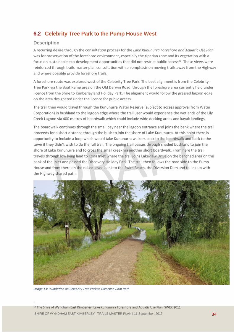
34 SHIRE OF WYNDHAM EAST KIMBERLEY | TRAILS MASTER PLAN | 11 September, 2017
6.2 Celebrity Tree Park to the Pump House West
Description
A recurring desire through the consultation process for the Lake Kununurra Foreshore and Aquatic Use Plan
was for preservation of the foreshore environment, especially the riparian zone and its vegetation with a
focus on sustainable eco-development opportunities that did not restrict public access19. These views were
reinforced through trails master plan consultation with an emphasis on moving trails away from the Highway
and where possible provide foreshore trails.
A foreshore route was explored west of the Celebrity Tree Park. The best alignment is from the Celebrity
Tree Park via the Boat Ramp area on the Old Darwin Road, through the foreshore area currently held under
licence from the Shire to Kimberleyland Holiday Park. The alignment would follow the grassed lagoon edge
on the area designated under the licence for public access.
The trail then would travel through the Kununurra Water Reserve (subject to access approval from Water
Corporation) in bushland to the lagoon edge where the trail user would experience the wetlands of the Lily
Creek Lagoon via 400 metres of boardwalk which could include wide decking areas and kayak landings.
The boardwalk continues through the small bay near the lagoon entrance and joins the bank where the trail
proceeds for a short distance through the bush to join the shore of Lake Kununurra. At this point there is
opportunity to include a loop which would take Kununurra walkers back to the boardwalk and back to the
town if they didn’t wish to do the full trail. The ongoing trail passes through shaded bushland to join the
shore of Lake Kununurra and to cross the small creek via another short boardwalk. From here the trail
travels through low lying land to Kona Inlet where the trail joins Lakeview Drive on the benched area on the
bank of the Inlet and passed the Discovery Holiday Park. The trail then follows the road side to the Pump
House and from there on the raised levee bank to the Swim Beach, the Diversion Dam and to link up with
the Highway shared path.
19 The Shire of Wyndham East Kimberley, Lake Kununurra Foreshore and Aquatic Use Plan, SWEK 2011
Image 13: Inundation on Celebrity Tree Park to Diversion Dam Path

35 SHIRE OF WYNDHAM EAST KIMBERLEY | TRAILS MASTER PLAN | 11 September, 2017
Demand
A trail through the Water Reserve will contribute significantly to the Kununurra visitor experience by
providing shoreline, wetland experience that is accessible by a range of people. The trail will also provide a
range of activities on the boardwalk including fishing, bird and wildlife watching and kayaking activities that
are not readily available to locals and visitors because of the limited access to the water.
Local people have made it clear from the Lake Kununurra Foreshore and Aquatic Use Plan and through
community feedback that recreational access to the shoreline is important and is currently limited. Visitors
to Kununurra area have limited access to the shoreline for walking, cycling and enjoying the unique and
internationally important wetlands of Lilly Creek Lagoon and Lake Kununurra.
Providing a new shoreline experience would be of interest to a range of visitors who visit and pass through
or visit Kununurra. It is anticipated that all market segments would benefit from and use this trail due to its
great water based experiences, its relatively short distance from town, the loop trail options and the range
of pick up and drop off opportunities.
The existing shared path alongside Victoria Highway is well used by walkers, runners and cyclists however
this activity is undertaken next to heavy vehicles, in the full sun and on a path that is subject to inundation
leaving the section of trail closed during the wet season. A shared use trail through the bushland and
wetlands would be well used and contribute to physical activity by existing users and encourage new
participants in activity.
Image 14: Lily Creek Lagoon Edge, Proposed Wetland Boardwalk Area
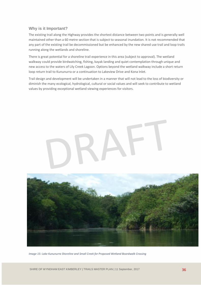
36 SHIRE OF WYNDHAM EAST KIMBERLEY | TRAILS MASTER PLAN | 11 September, 2017
Why is it Important?
The existing trail along the Highway provides the shortest distance between two points and is generally well
maintained other than a 60 metre section that is subject to seasonal inundation. It is not recommended that
any part of the existing trail be decommissioned but be enhanced by the new shared use trail and loop trails
running along the wetlands and shoreline.
There is great potential for a shoreline trail experience in this area (subject to approval). The wetland
walkway could provide birdwatching, fishing, kayak landing and quiet contemplation through unique and
new access to the waters of Lily Creek Lagoon. Options beyond the wetland walkway include a short return
loop return trail to Kununurra or a continuation to Lakeview Drive and Kona Inlet.
Trail design and development will be undertaken in a manner that will not lead to the loss of biodiversity or
diminish the many ecological, hydrological, cultural or social values and will seek to contribute to wetland
values by providing exceptional wetland viewing experiences for visitors.
Image 15: Lake Kununurra Shoreline and Small Creek for Proposed Wetland Boardwalk Crossing

37 SHIRE OF WYNDHAM EAST KIMBERLEY | TRAILS MASTER PLAN | 11 September, 2017
What needs to be done to deliver the Project?
The water side trail and wetland boardwalk is contained within or accessed through the Kununurra Water
Reserve (Priority One Protection Area - P1), important for Kununurra water supply and vested in the Water
Corporation. In P1 areas the objective is risk avoidance and any additional land use intensification is not
typically supported. Accordingly, any development proposals within the land and along the adjoining
foreshore reserve must be assessed for impact on the quality of Kununurra’s drinking water source. The
Water Corporation manages the Public Drinking Water Protection Zone and the bore fields that supply the
town with good quality drinking water and would need to approve any trail development within this area.
In addition to the approval process there are significant challenges in providing sustainable trails through
this area as much of the southern and western area is subject to seasonal inundation. Trails would need to
be raised through a combination of raised compacted gravel with spray seal bitumen, duckboards,
boardwalks and the wetland walkway. The construction method will be determined however there are
innovative and contemporary products that could be utilised that support the principles of environmental
protection (Lake Kununurra is an internationally significant wetland protected under the Ramsar
Convention), sustainability, long asset life, and low maintenance. Site specific management issues such as
control of the reed Cumbungie would need to be incorporated in any on the water design.
The Kimberley Land Holiday Park is licensed to occupy the foreshore of Lily Creek Lagoon, it is a condition of
the licence that public access is provided to the foreshore. Access issues should be minimised and
consultation should take place regarding trail routes through the Holiday Park.
It is anticipated there will be strong community support for this initiative. Community assistance in
stewardship and management of this trail will be important for its success and to assist in reducing any
potential impacts on the sensitive water supply area.
To implement this project will require additional engineering, landscape design and cultural heritage and
environmental assessment.
The Shire of Wyndham Kununurra will have responsibility for this project in partnership with the Water
Corporation as the primary land owner.
Image 16: Examples of Concrete Boardwalk Wetland Trails
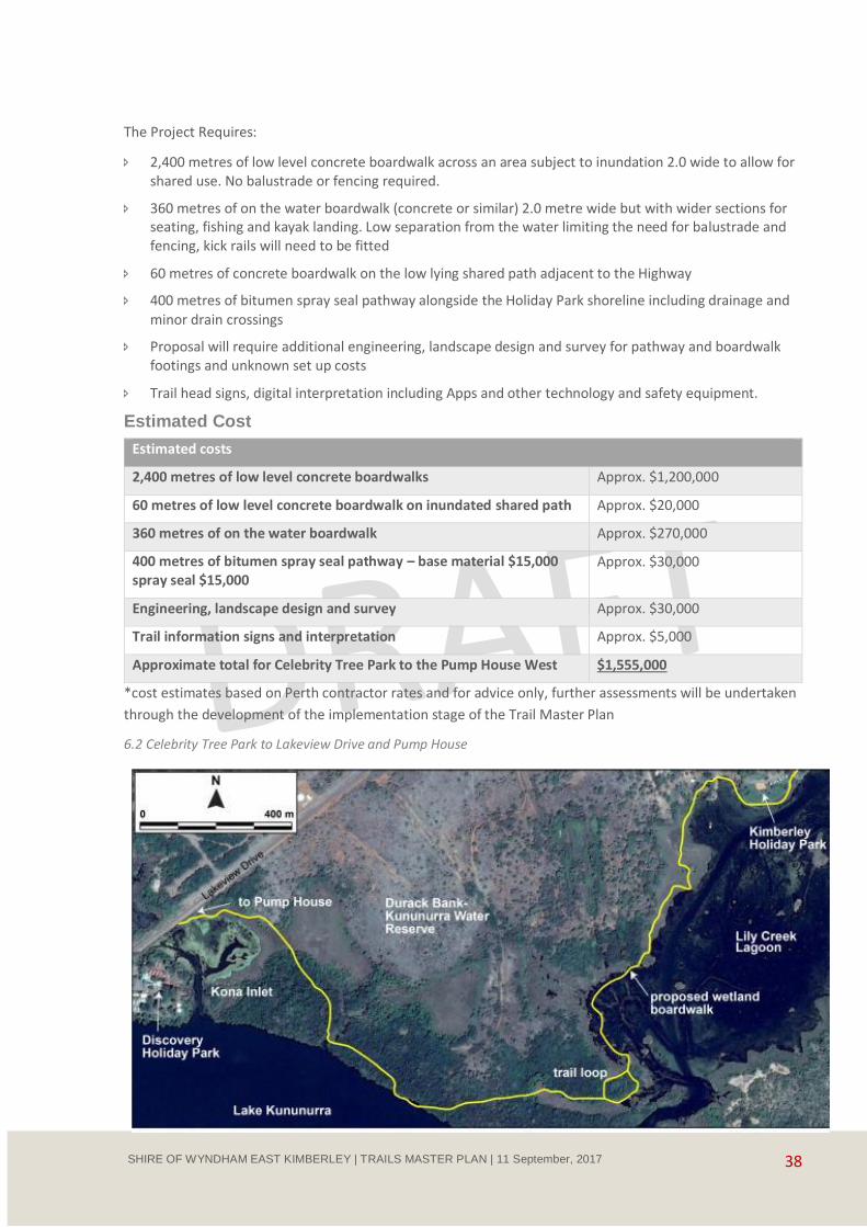
38 SHIRE OF WYNDHAM EAST KIMBERLEY | TRAILS MASTER PLAN | 11 September, 2017
The Project Requires:
2,400 metres of low level concrete boardwalk across an area subject to inundation 2.0 wide to allow for shared use. No balustrade or fencing required.
360 metres of on the water boardwalk (concrete or similar) 2.0 metre wide but with wider sections for seating, fishing and kayak landing. Low separation from the water limiting the need for balustrade and fencing, kick rails will need to be fitted
60 metres of concrete boardwalk on the low lying shared path adjacent to the Highway
400 metres of bitumen spray seal pathway alongside the Holiday Park shoreline including drainage and
minor drain crossings
Proposal will require additional engineering, landscape design and survey for pathway and boardwalk footings and unknown set up costs
Trail head signs, digital interpretation including Apps and other technology and safety equipment.
Estimated Cost
Estimated costs
2,400 metres of low level concrete boardwalks Approx. $1,200,000
60 metres of low level concrete boardwalk on inundated shared path Approx. $20,000
360 metres of on the water boardwalk Approx. $270,000
400 metres of bitumen spray seal pathway – base material $15,000 spray seal $15,000
Approx. $30,000
Engineering, landscape design and survey Approx. $30,000
Trail information signs and interpretation Approx. $5,000
Approximate total for Celebrity Tree Park to the Pump House West $1,555,000
*cost estimates based on Perth contractor rates and for advice only, further assessments will be undertaken
through the development of the implementation stage of the Trail Master Plan
6.2 Celebrity Tree Park to Lakeview Drive and Pump House

39 SHIRE OF WYNDHAM EAST KIMBERLEY | TRAILS MASTER PLAN | 11 September, 2017
6.3 Lakeside to Equestrian Park, BMX Skills Park and Mirima National
Park Mountain Biking
Description
A focus of this trail plan is to develop high quality and diverse trail experiences for a range of recreational
pursuits. The racecourse and associated lands south of Kununurra have been identified as an area of high
potential for tourism activities, other sports and public events and possibly a caravan park.20 This area will
have strong trail connections to the town, to Lakeside Residential Estate, to the new subdivisions to the
south east of the Estate and to the future recreational themes including BMX Skills Park, Dragon Boat Racing
and potential Mountain Biking destinations in Mirima National Park.
There are currently uncoordinated trails around the western side of Lakeside and to the south of the Estate
where local people undertake casual recreation activities including running, walking, dog exercising and bike
riding. The area to the south is also used for off road motor bike and quad bike riding.
Water access is an important theme in the development of trail opportunities in Kununurra. There are
currently random trails to the west of Lakeside that can be improved to provide access for the range of users
together with providing non-urban trail access to the trail and recreation facilities to the south. It is
proposed to develop a trail circuit around Lakeside on the Lagoon edge and including the public access
corridor in the area Licenced by the Shire to the Lakeside Caravan Park.
The Shire of Wyndham-East Kimberley is considering the future of the leisure and aquatic centre in
Kununurra, which is currently reaching the end of its facility life cycle. The Shire is proactively considering the
future location of leisure facilities and the long term growth of the town. A business case has been
developed which recognises the need to provide ongoing leisure and aquatic facilities whilst developing the
most functional, cost effective and flexible facilities possible. The business case has considered the East Lily
Creek area on the eastern side of Victoria Highway bounded by Lily Creek and Mirima National Park.
The East Lily Creek area identified as an appropriate location for urban development, community centres
and leisure and aquatic facilities provides both a trail destination and a trail link. It has the potential to
provide a solution for pedestrian and cycling access across the Victoria Highway for mountain biking and
other recreational trail access to Mirima National Park from Lakeside and trails planned for that area as the
East Lily Creek area proposal includes a significant pedestrian crossing facility. It is anticipated that planning
for this facility and development will commence in 201821.
A BMX Skills Park facility has been approved for development on the shore of Lake Kununurra which will
provide a local focus for biking and other recreation. The BMX facility would greatly benefit from off road
trail access from Kununurra.
There is a commitment from the small but enthusiastic Kununurra mountain bike community to develop
trails in the Mirima National Park, this proposal has the support of the Department Biodiversity,
Conservation and Attractions, Parks and Wildlife Service.
Mirima National Park provides great potential for mountain biking particularly in the central and eastern
areas of the park. There is a small but growing interest in mountain bike riding in the community and the
commencement of a BMX track on the shore of Lake Kununurra 2-3 kilometres from the park provides a
20 The Shire of Wyndham East Kimberley, Lake Kununurra Foreshore and Aquatic Use Plan, SWEK 2011 21 www.swek.wa.gov.au/Assets/Documents/.../Kununurra_Draft_Structure_Plans.pdf
40 SHIRE OF WYNDHAM EAST KIMBERLEY | TRAILS MASTER PLAN | 11 September, 2017
local focus for biking. Kununurra is not considered as an iconic national mountain biking destination but it
has the potential for strong local and developing regional importance.
There is currently no adopted management plan for Mirima National Park therefore future access for
mountain biking in the park will be considered based on the merits of the proposal including level of demand
and assessment of risk to the cultural, heritage, social and environmental values of the park. Future
mountain bike trail development will also be based on the Draft Western Australian Mountain Bike
Guidelines (in preparation) which provides a compatibility guide for sustainable mountain bike trails on Parks
and Wildlife-managed land22. It is proposed that a mountain bike trail network which may include feeder
trails, single track, cross country, all mountain and touring trails be considered for an area of the park with
suitable topography and soil and rock type east of the main range.
The mountain bike zone would allow for a range of trail difficulty levels varying from easy to intermediate to
difficult. It is not the intention of this plan to identify the exact location for individual trails but it will
consider a zoning area identified for future sustainable mountain bike trail construction and will be subject
to DBCA policy and approval process. A specific and detailed trail plan will be required for future trail
construction utilising mountain bike planning and construction expertise.
Links and access to the BMX track, future recreation activities and mountain bike experiences would benefit
from shared use trails from Kununurra through Lakeside and the bushland area to the Lake Kununurra
shoreline and Mirima National Park. Appropriate planned trails would provide a range of riders the
opportunity to undertake activities safely without having to use the Highway.
Two trail routes are proposed one will utilise existing trails and will incorporate new trail alignments around
the western shoreline of the Estate and where possible connecting with Lily Creek Lagoon. The trail will be
designed for shared use and will start at the Lily Creek footbridge and connect with a trail junction at the
small causeway south of Setosa Pass.
The trail junction near Sentosa Pass will also join an urban marked trail option through the Estate that
provides access following reserves from Flametree Street via Hibiscus Drive and on to the pathways along
Setosa Pass and Gardenia Drive.
Trails south of this area are subject to inundation and are generally on sandy or black soils, both soil profiles
are problematic for sustainable trail building. The Old Darwin Road runs in a north west -south east direction
west of Lakeside and is virtually disused. This road provides a solid base for trails and other than a few small
bog holes during the wet season the trail is the best option for a sustainable trail route. The road is however
not directly accessible from Lakeside due to a tributary of Lily Creek running between the road and Lakeside.
It is proposed to provide a trail crossing and wetland trail on the tributary and making the crossing a loop
trail from the Lakeside that provides walking opportunities for the people of Lakeside, the town and visitors.
The trail up to the wetland crossing should be a shared use trail designed for a broad range of users, beyond
the crossing the trails can be rubble suitable for walkers, mountain bikers and dog exercising.
An additional short cut will be required off the Old Darwin Road to the west towards the BMX and cycling
Skills Park and this will be subject to further assessments of suitable alignments and soil type.
22 Department of Parks and Wildlife 2017. Draft Western Australian Mountain Bike Management Guidelines, Draft Report for
Western Australian Mountain Bike Management Guidelines Working Group,
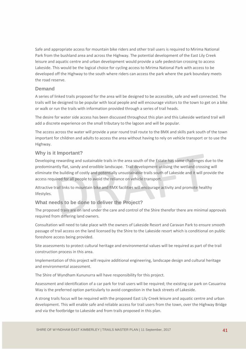
41 SHIRE OF WYNDHAM EAST KIMBERLEY | TRAILS MASTER PLAN | 11 September, 2017
Safe and appropriate access for mountain bike riders and other trail users is required to Mirima National
Park from the bushland area and across the Highway. The potential development of the East Lily Creek
leisure and aquatic centre and urban development would provide a safe pedestrian crossing to access
Lakeside. This would be the logical choice for cycling access to Mirima National Park with access to be
developed off the Highway to the south where riders can access the park where the park boundary meets
the road reserve.
Demand
A series of linked trails proposed for the area will be designed to be accessible, safe and well connected. The
trails will be designed to be popular with local people and will encourage visitors to the town to get on a bike
or walk or run the trails with information provided through a series of trail heads.
The desire for water side access has been discussed throughout this plan and this Lakeside wetland trail will
add a discrete experience on the small tributary to the lagoon and will be popular.
The access across the water will provide a year round trail route to the BMX and skills park south of the town
important for children and adults to access the area without having to rely on vehicle transport or to use the
Highway.
Why is it Important?
Developing rewarding and sustainable trails in the area south of the Estate has some challenges due to the
predominantly flat, sandy and erodible landscape. Trail development utilising the wetland crossing will
eliminate the building of costly and potentially unsustainable trails south of Lakeside and it will provide the
access required for all people to avoid the reliance on vehicle transport.
Attractive trail links to mountain bike and BMX facilities will encourage activity and promote healthy
lifestyles.
What needs to be done to deliver the Project?
The proposed trails are on land under the care and control of the Shire therefor there are minimal approvals
required from differing land owners.
Consultation will need to take place with the owners of Lakeside Resort and Caravan Park to ensure smooth
passage of trail access on the land licensed by the Shire to the Lakeside resort which is conditional on public
foreshore access being provided.
Site assessments to protect cultural heritage and environmental values will be required as part of the trail
construction process in this area.
Implementation of this project will require additional engineering, landscape design and cultural heritage
and environmental assessment.
The Shire of Wyndham Kununurra will have responsibility for this project.
Assessment and identification of a car park for trail users will be required; the existing car park on Casuarina
Way is the preferred option particularly to avoid congestion in the back streets of Lakeside.
A strong trails focus will be required with the proposed East Lily Creek leisure and aquatic centre and urban
development. This will enable safe and reliable access for trail users from the town, over the Highway Bridge
and via the footbridge to Lakeside and from trails proposed in this plan.
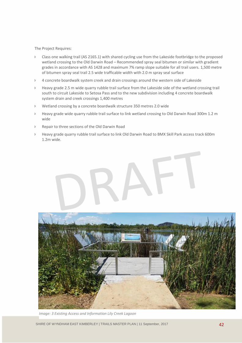
42 SHIRE OF WYNDHAM EAST KIMBERLEY | TRAILS MASTER PLAN | 11 September, 2017
The Project Requires:
Class one walking trail (AS 2165.1) with shared cycling use from the Lakeside footbridge to the proposed wetland crossing to the Old Darwin Road – Recommended spray seal bitumen or similar with gradient grades in accordance with AS 1428 and maximum 7% ramp slope suitable for all trail users. 1,500 metre of bitumen spray seal trail 2.5 wide trafficable width with 2.0 m spray seal surface
4 concrete boardwalk system creek and drain crossings around the western side of Lakeside
Heavy grade 2.5 m wide quarry rubble trail surface from the Lakeside side of the wetland crossing trail south to circuit Lakeside to Setosa Pass and to the new subdivision including 4 concrete boardwalk
system drain and creek crossings 1,400 metres
Wetland crossing by a concrete boardwalk structure 350 metres 2.0 wide
Heavy grade wide quarry rubble trail surface to link wetland crossing to Old Darwin Road 300m 1.2 m wide
Repair to three sections of the Old Darwin Road
Heavy grade quarry rubble trail surface to link Old Darwin Road to BMX Skill Park access track 600m 1.2m wide.
Image: 3 Existing Access and Information Lily Creek Lagoon

43 SHIRE OF WYNDHAM EAST KIMBERLEY | TRAILS MASTER PLAN | 11 September, 2017
Estimated costs
Lakeside footbridge to wetland crossing
1,500 metres of bitumen spray seal pathway – base material $45,000 spray seal $60,000
4 creek and drain crossings $40,000
This section $145,000
Wetland Crossing to Setosa Pass and new subdivision
1,400 metres quarry rubble track $525,000
4 creek and drain crossings $40,000
This section $565,000
Wetland Crossing and Old Darwin Road
350 metre concrete boardwalk $210,000
300 m quarry rubble track to Old Darwin Road 1.2m $6,000
3 sections repair Old Darwin Road $4,000
This section $220,000
Old Darwin Road to Recreation Area Lake Kununurra Shore
600 m quarry rubble track to BMX Skill Park 1.2m $10,000
This section $10,000
Engineering, landscape design and survey Approx. $30,000
Trail information signs and interpretation Approx $5,000
Lakeside to Equestrian Park, BMX, Skills Park and Mirima National Park Mountain Biking
Estimated Total $975,000
6.3 Lakeside Trails

44 SHIRE OF WYNDHAM EAST KIMBERLEY | TRAILS MASTER PLAN | 11 September, 2017
6.4 Lakeside and Old Darwin Road Trails - Lakeside to Equestrian Park and Proposed East Lily Creek Area

45 SHIRE OF WYNDHAM EAST KIMBERLEY | TRAILS MASTER PLAN | 11 September, 2017
6.4 Kayaking and non-motorised water activity
Description
Lake Kununurra, Lily Creek Lagoon and the associated wetlands provide excellent sheltered water for
canoeing, kayaking and other activities such as stand up paddle boarding.
The southern shore of Lake Kununurra including Packsaddle Lagoon that is jointly managed by the
Miriuwung Gajerrong Corporation and the DBCA provides excellent kayaking experiences in amongst the
snags, overhanging trees and wetlands.
Upstream from the Kununurra Racecourse Elephant Rock and adjacent lagoons, backwaters and inlets
provide memorable kayaking experiences that can be combined with an energetic hike to the top of the
Buddha escarpment.
Commercial canoe camps and tour rest areas between Spillway Creek and Carlton Gorge are used by
customers of commercial tourism companies enjoying either overnight canoeing or sightseeing day and half
day trips.
Kayak tours on Lake Kununurra, Lily Creek Lagoon and the adjacent lagoons are available and kayaks and
canoes can be hired from a number of places around the lakes.
The introduction of Barramundi fingerlings into Lake Kununurra is establishing a stable fish population which
should increase the interest in fishing within the lake which in turn is likely to attract increased numbers of
recreational kayak fishers.
Demand
Experiencing Lake Kununurra, its inlets and wetlands and the more adventurous overnight canoeing trips
from Lake Argyle are unique Ord River experiences that will see increased interest from visitors and locals.
The development of a purpose built kayak and non-motorised launching facility east of the Celebrity Tree
Park would provide a greater focus on water sports and would build awareness of visitors as to water based
opportunities and build demand.
The development of further water based information and opportunity would increase awareness.
Image 17: Ord River, Carlton Gorge
46 SHIRE OF WYNDHAM EAST KIMBERLEY | TRAILS MASTER PLAN | 11 September, 2017
Why is it Important?
There are opportunities to further promote these non-motorised water based experiences.
The plan does not recommend the establishment of marked kayak trails and considers self-exploration
guided by good pre-visit and self-guided maps, Apps and launch site trail signs as the most appropriate way
to guide rewarding on water experiences.
What needs to be done to deliver the Project?
Information for visitors on locations and kayaking routes would need to be coordinated and provided
through visitor centres and information outlets. The placement of information signs at boat ramps and no-
motorised launching sites could provide visitors and locals with the directions and information on how to
enjoy the waterways.
The proposed trail and wetland boardwalk near the entrance channel to Lilly Creek Lagoon (see 6.1.1 above)
would provide an excellent destination where kayakers could step on to the landing and explore the trails
through the bush.
The Ord River overnight kayak trail is an iconic experience which can only develop over time. This experience
has the potential to be marketed as a future trail of State Significance. This experience needs to be assessed
in the future linked to Lake Argyle trail and visitors experiences that require specific planning.
Estimated Cost
Promotion
pre-visit and self-guided maps, apps and launch site trail signs Approx $40,000
6.5 Wyndham
Description
The main visitor attractions in Wyndham are the historic port and the spectacular views from the Five Rivers
Lookout on the Bastion. Trails provide a small contribution to the Wyndham visitor experience and provide
facilities where the community can exercise. For example the Wyndham Port Path, when not damaged
provides a safe alternative to the Highway for walking and cycling between the communities.
The Port Path is a 4.2 km cycle (shared use) path from Wyndham to the port running parallel to the Highway.
Use of the Port path is limited due to extensive damage to the trail surface caused by flooding, erosion and
deposition of material on the path from land slips and run off from the hills above the path.
The path was proposed for upgrading under the Draft Local Planning Strategy and Scheme and a proposal for
the upgrading of the path was documented in the report Dual Use Path Improvements, prepared by
Blackwell & Associates for SWEK August 2012.
In addition to the Port Path the Six Mile Community Trail is a 2.5 km Cycle (shared use) path from Wyndham
to the Six Mile Community used generally by local people e.g. the local football club for fitness training. This
section of path is serviceable and is in better condition than the Port Path however the creek crossing at Six
Mile is damaged beyond repair.
There are walking trails to the Five Rivers Lookout on The Bastion. Two trails loop around the Bastion on the
west and east sides starting at the quarry car park mid-way (2.6 km) up the Hugo Austla Drive. The trails
provide exceptional views of the Five Rivers, the Cambridge Gulf and Kimberley Landscape.
47 SHIRE OF WYNDHAM EAST KIMBERLEY | TRAILS MASTER PLAN | 11 September, 2017
The trail routes are difficult to follow due to grass growth and the rocks used as way marking are hidden. The
gradient is good on the wester trail with average 5.6% whilst the eastern trail has a steeper average gradient
of 9%. The trails require some maintenance including grade reversal work to reduce erosion on a section
near the lookout on the western trail as the eastern trail is steeper there is more erosion control required
and in parts the trail is placed on a drainage line. At times better walking on the eastern trail is off the trail
indicating the need for rerouting short sections.
A walking trail from the Three Mile Valley to Five Rivers Lookout was established however there has been
little maintenance and the walking trail is now overgrown and difficult to identify.
Demand
The Port Path and Six Mile Community Trail provides a valuable community resource that with significant
maintenance and promotion could encourage activity, recreation and social interaction.
There is some benefit for visitors to Wyndham who may use the Port Path to walk to and from the Port
however the use by visitors is considered limited. It is recommended that for community benefit the Port
Path be reinstated.
The two trails around the Bastion and to the Five Rivers Lookout provide good experiences (as Class 3 Trails)
for visitors picking up on some of the best views. The Trail from Three Mile Valley to Five Mile Lookout has
virtually disappeared and would require significant investment to reinstate the trail to an appropriate
standard (Class 4). The anticipated use of this trail would not justify the investment of the ongoing
maintenance required. A small number of local people use the Hugo Austla Drive for exercise and training
for endurance sports utilising the roads steep ascent.
Some interest has been expressed from the mountain bike community to develop a downhill mountain bike
trail from the Bastion to the Three Mile Valley. The potential downhill trail would be a good mountain biking
experience based on the opportunity for vehicle bike pick up and drop off via the road to the top, the
spectacular landscapes, the geology of the area and the gradient. The demand for the downhill trail would
need to be demonstrated together with an ability and desire of the community to develop and maintain the
trail using community resources. The Shire has care and control and ultimate responsibility for the land and
trails and would need to be assured that there is little further impact on the Shires limited resources.
Upgrading of the walking trail from the bottom to the top would need to be developed to sustainable
standards and be less than a 10% average slope. In this area this would be problematic as evidenced by the
eastern Bastion trail which tends to follow the contour and is not that steep but is suffering from erosion. If
the modified sustainable gradient was achieved it would not necessarily suit the regular users of the Hugo
Austla Drive who seek the endurance style of exercise. It is recommended that suitable advisory signs be
placed on the Hugo Austla Drive to make the road more friendly for walkers and runners and that no
reinstatement be undertaken on the trail from the bottom to the top.
The short walk from the Three Mile day visit area to the waterholes is an easy and locally popular walk
however only locals know where it is. This can easily be rectified by placement of a trail head sign and some
simple way marking signs.
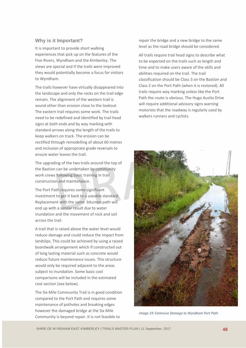
48 SHIRE OF WYNDHAM EAST KIMBERLEY | TRAILS MASTER PLAN | 11 September, 2017
Why is it Important?
It is important to provide short walking
experiences that pick up on the features of the
Five Rivers, Wyndham and the Kimberley. The
views are special and if the trails were improved
they would potentially become a focus for visitors
to Wyndham.
The trails however have virtually disappeared into
the landscape and only the rocks on the trail edge
remain. The alignment of the western trail is
sound other than erosion close to the lookout.
The eastern trail requires some work. The trails
need to be redefined and identified by trail head
signs at both ends and by way marking with
standard arrows along the length of the trails to
keep walkers on track. The erosion can be
rectified through remodelling of about 60 metres
and inclusion of appropriate grade reversals to
ensure water leaves the trail.
The upgrading of the two trails around the top of
the Bastion can be undertaken by community
work crews following basic training in trail
construction and maintenance.
The Port Path requires some significant
investment to get it back to a useable standard.
Replacement with the same bitumen path will
end up with a similar result due to water
inundation and the movement of rock and soil
across the trail.
A trail that is raised above the water level would
reduce damage and could reduce the impact from
landslips. This could be achieved by using a raised
boardwalk arrangement which if constructed out
of long lasting material such as concrete would
reduce future maintenance issues. This structure
would only be required adjacent to the areas
subject to inundation. Some basic cost
comparisons will be included in the estimated
cost section (see below).
The Six Mile Community Trail is in good condition
compared to the Port Path and requires some
maintenance of potholes and breaking edges
however the damaged bridge at the Six Mile
Community is beyond repair. It is not feasible to
repair the bridge and a new bridge to the same
level as the road bridge should be considered.
All trails require trail head signs to describe what
to be expected on the trails such as length and
time and to make users aware of the skills and
abilities required on the trail. The trail
classification should be Class 3 on the Bastion and
Class 2 on the Port Path (when it is restored). All
trails require way marking unless like the Port
Path the route is obvious. The Hugo Austla Drive
will require additional advisory signs warning
motorists that the roadway is regularly used by
walkers runners and cyclists.
Image 19: Extensive Damage to Wyndham Port Path
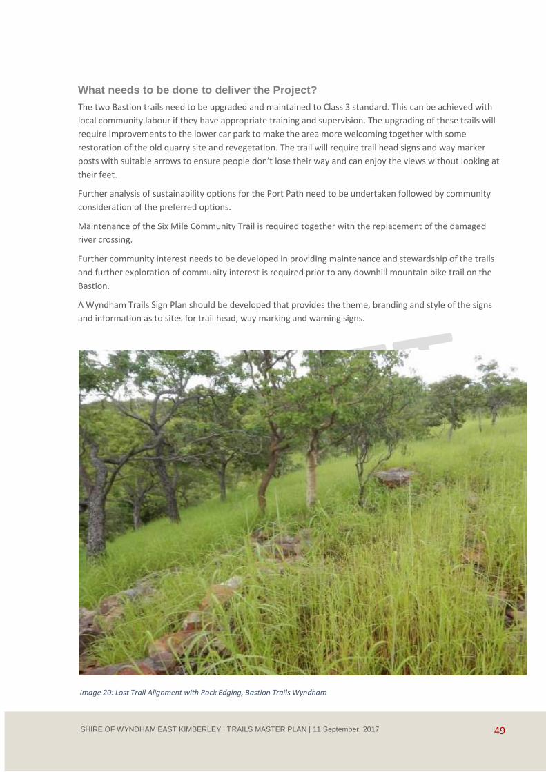
49 SHIRE OF WYNDHAM EAST KIMBERLEY | TRAILS MASTER PLAN | 11 September, 2017
What needs to be done to deliver the Project?
The two Bastion trails need to be upgraded and maintained to Class 3 standard. This can be achieved with
local community labour if they have appropriate training and supervision. The upgrading of these trails will
require improvements to the lower car park to make the area more welcoming together with some
restoration of the old quarry site and revegetation. The trail will require trail head signs and way marker
posts with suitable arrows to ensure people don’t lose their way and can enjoy the views without looking at
their feet.
Further analysis of sustainability options for the Port Path need to be undertaken followed by community
consideration of the preferred options.
Maintenance of the Six Mile Community Trail is required together with the replacement of the damaged
river crossing.
Further community interest needs to be developed in providing maintenance and stewardship of the trails
and further exploration of community interest is required prior to any downhill mountain bike trail on the
Bastion.
A Wyndham Trails Sign Plan should be developed that provides the theme, branding and style of the signs
and information as to sites for trail head, way marking and warning signs.
Image 20: Lost Trail Alignment with Rock Edging, Bastion Trails Wyndham
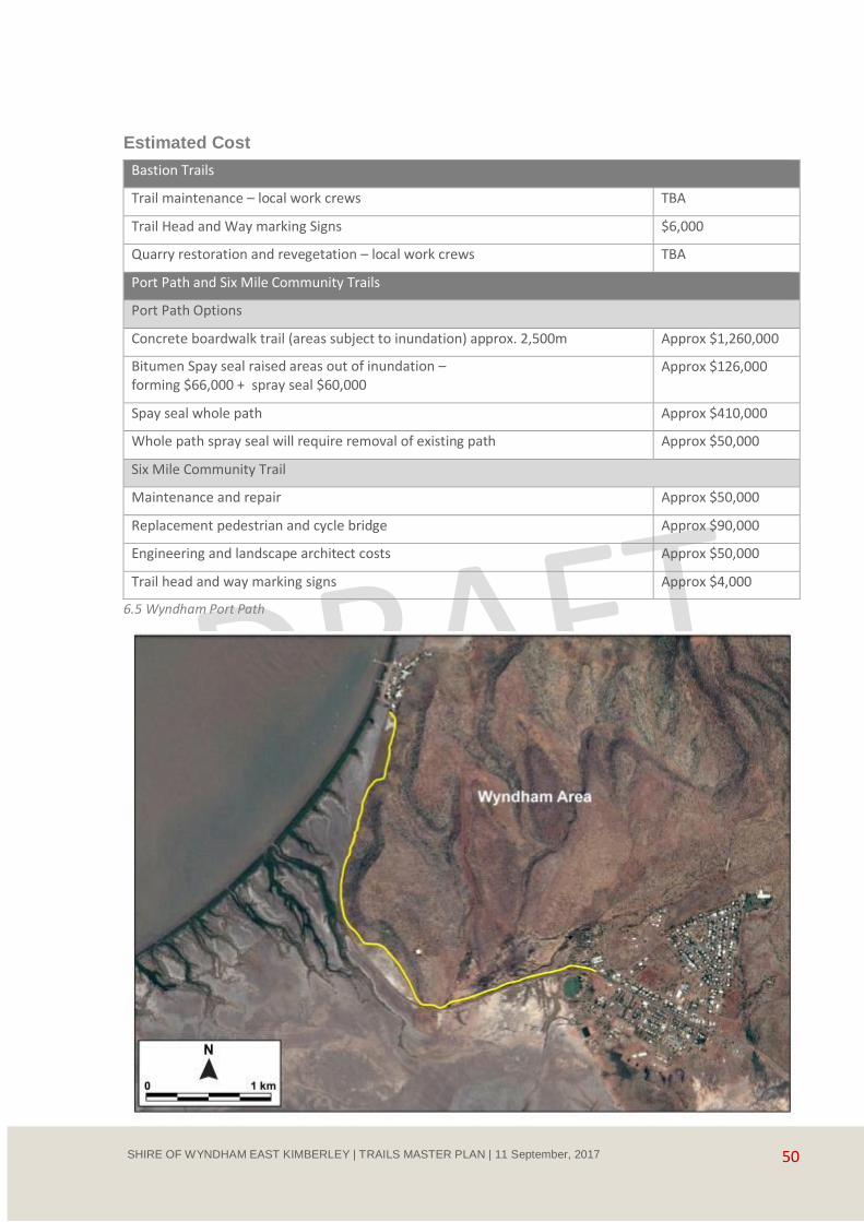
50 SHIRE OF WYNDHAM EAST KIMBERLEY | TRAILS MASTER PLAN | 11 September, 2017
Estimated Cost
Bastion Trails
Trail maintenance – local work crews TBA
Trail Head and Way marking Signs $6,000
Quarry restoration and revegetation – local work crews TBA
Port Path and Six Mile Community Trails
Port Path Options
Concrete boardwalk trail (areas subject to inundation) approx. 2,500m Approx $1,260,000
Bitumen Spay seal raised areas out of inundation – forming $66,000 + spray seal $60,000
Approx $126,000
Spay seal whole path Approx $410,000
Whole path spray seal will require removal of existing path Approx $50,000
Six Mile Community Trail
Maintenance and repair Approx $50,000
Replacement pedestrian and cycle bridge Approx $90,000
Engineering and landscape architect costs Approx $50,000
Trail head and way marking signs Approx $4,000
6.5 Wyndham Port Path
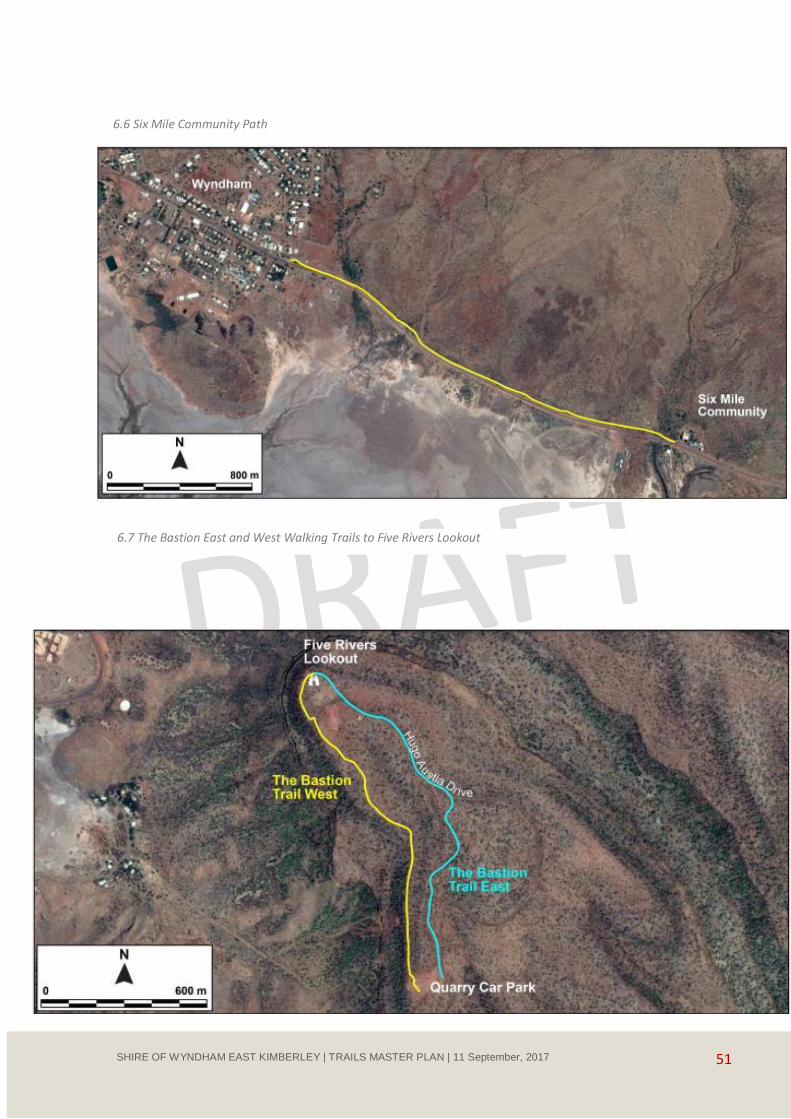
51 SHIRE OF WYNDHAM EAST KIMBERLEY | TRAILS MASTER PLAN | 11 September, 2017
6.6 Six Mile Community Path
6.7 The Bastion East and West Walking Trails to Five Rivers Lookout

52 SHIRE OF WYNDHAM EAST KIMBERLEY | TRAILS MASTER PLAN | 11 September, 2017
6.6 Lake Argyle, Spillway Creek and Ord River
Lake Argyle is Western Australia's largest and Australia's second largest freshwater man-made reservoir by
volume. The Lake, Ord River, Spillway Creek and the surrounding remote ranges provide the ideal setting for
trail based experiences. The area is utilised for walking, water sports, guided overnight walking, mountain
biking and for endurance events such as the Lake Argyle Adventure Race, an annual swim, paddle, run and
mountain biking race.
Mountain biking takes place on the Rotary Lake Argyle Mountain Bike Track, a 4.95 km moderate grade track
overlooking the lake.
Guided wilderness walking take place in the ranges that surround Lake Argyle and guided kayak trips take
place from the dam wall to Kununurra.
Many people access the Spillway Creek for walking and fishing both on foot and by vehicle. The Spillway
Creek Visitor Area has been closed for many years due to the significant public risk issues associate with the
high flows around the outlet from Lake Argyle.
The distance and cost of getting to the East Kimberley and Lake Argyle area by visitors from the capital cities
is a constraint on the development of future trail based experiences. There are initiatives being developed to
encourage visitors from the capital cities including direct flights from Melbourne, these are expected to
commence in 2018.
The Lake Argyle area is a popular recreation destination for the residents of the East Kimberley being 70
kilometres from Kununurra.
The development of a range of successful trails on Lake Argyle, around the hills and ranges and on the rivers
outflowing from the Lake requires significant planning and assessment which is beyond the scope of this
plan. It is recommended that further investigation and analysis of recreation tourism and trail opportunities
be undertaken in the near future for Lake Argyle and the surrounding area.
6.7 Cockburn Ranges
A feasibility study was undertaken in 2013 (TRC Tourism 2013) for an iconic walk in the south-east part of
the Cockburn Range lying west of Kununurra in the northern Kimberley. The area is bounded to the south by
the northern end of the Gibb River Road and to the north of the Emma Gorge Resort. The land is currently
part of the 4,000 square kilometre El Questro pastoral lease.
As part of the process for renewal of Western Australian pastoral leases, the Cockburn Range was
surrendered from the El Questro lease in 2015 to become a national park jointly-managed by the
Department of Biodiversity, Conservation and Attractions and the Balangarra Aboriginal Corporation.
While negotiations are yet to be concluded, it is proposed that an icon walk in the south-east Cockburn
Range be established with two components:
• the Kimberley Wilderness Experience – a fully guided fly-in and fly-out experience utilising quality tented
or other semi-permanent accommodation at a base camp
• the Kimberley Trail - an independent walk for well-equipped, self-sufficient walkers, potentially with
overnight camping in small huts similar to the Bibbulmun Track
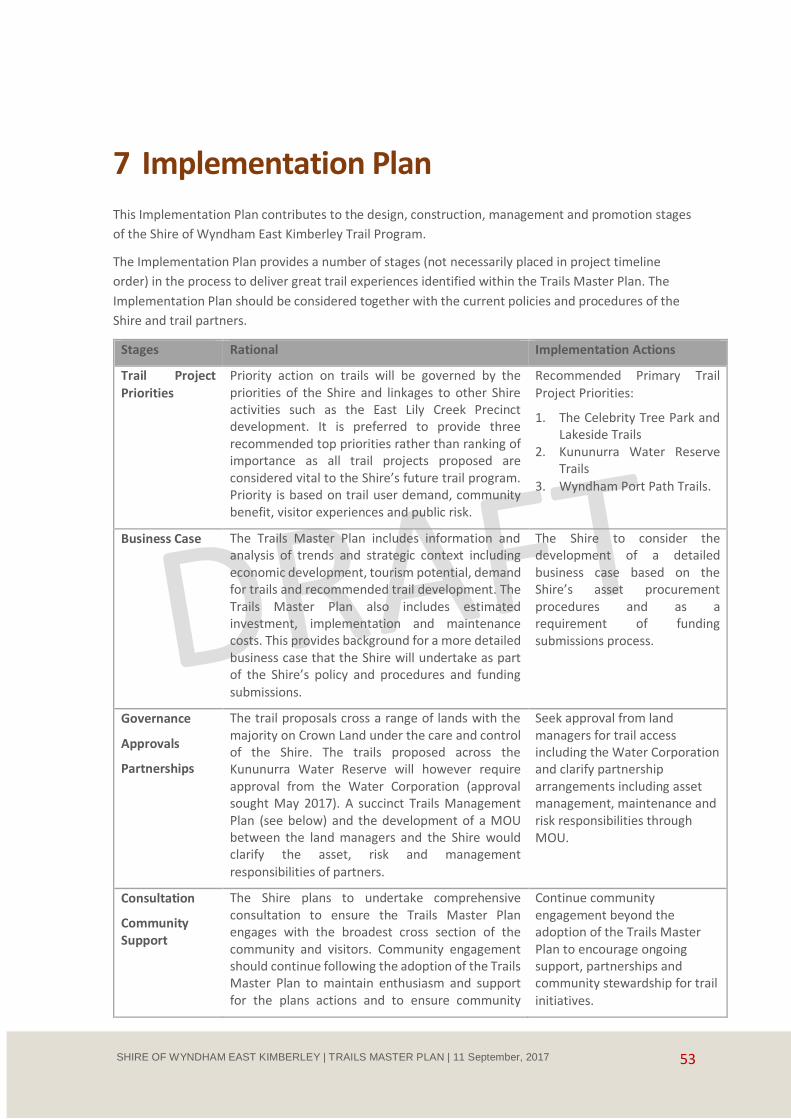
53 SHIRE OF WYNDHAM EAST KIMBERLEY | TRAILS MASTER PLAN | 11 September, 2017
7 Implementation Plan
This Implementation Plan contributes to the design, construction, management and promotion stages
of the Shire of Wyndham East Kimberley Trail Program.
The Implementation Plan provides a number of stages (not necessarily placed in project timeline
order) in the process to deliver great trail experiences identified within the Trails Master Plan. The
Implementation Plan should be considered together with the current policies and procedures of the
Shire and trail partners.
Stages Rational Implementation Actions
Trail Project
Priorities
Priority action on trails will be governed by the priorities of the Shire and linkages to other Shire activities such as the East Lily Creek Precinct development. It is preferred to provide three recommended top priorities rather than ranking of importance as all trail projects proposed are considered vital to the Shire’s future trail program. Priority is based on trail user demand, community benefit, visitor experiences and public risk.
Recommended Primary Trail
Project Priorities:
1. The Celebrity Tree Park and Lakeside Trails
2. Kununurra Water Reserve Trails
3. Wyndham Port Path Trails.
Business Case The Trails Master Plan includes information and analysis of trends and strategic context including economic development, tourism potential, demand for trails and recommended trail development. The Trails Master Plan also includes estimated investment, implementation and maintenance costs. This provides background for a more detailed business case that the Shire will undertake as part of the Shire’s policy and procedures and funding
submissions.
The Shire to consider the development of a detailed business case based on the Shire’s asset procurement procedures and as a requirement of funding submissions process.
Governance
Approvals
Partnerships
The trail proposals cross a range of lands with the majority on Crown Land under the care and control of the Shire. The trails proposed across the Kununurra Water Reserve will however require approval from the Water Corporation (approval sought May 2017). A succinct Trails Management Plan (see below) and the development of a MOU between the land managers and the Shire would clarify the asset, risk and management
responsibilities of partners.
Seek approval from land managers for trail access including the Water Corporation and clarify partnership arrangements including asset management, maintenance and risk responsibilities through MOU.
Consultation
Community Support
The Shire plans to undertake comprehensive consultation to ensure the Trails Master Plan engages with the broadest cross section of the community and visitors. Community engagement should continue following the adoption of the Trails Master Plan to maintain enthusiasm and support for the plans actions and to ensure community
Continue community engagement beyond the adoption of the Trails Master Plan to encourage ongoing support, partnerships and community stewardship for trail
initiatives.
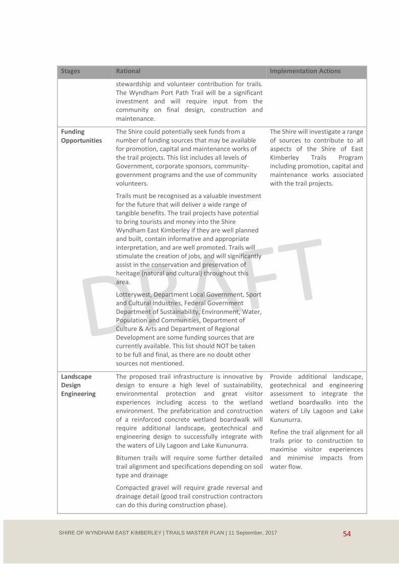
54 SHIRE OF WYNDHAM EAST KIMBERLEY | TRAILS MASTER PLAN | 11 September, 2017
Stages Rational Implementation Actions
stewardship and volunteer contribution for trails. The Wyndham Port Path Trail will be a significant investment and will require input from the community on final design, construction and
maintenance.
Funding
Opportunities
The Shire could potentially seek funds from a number of funding sources that may be available for promotion, capital and maintenance works of the trail projects. This list includes all levels of Government, corporate sponsors, community-government programs and the use of community volunteers.
Trails must be recognised as a valuable investment for the future that will deliver a wide range of tangible benefits. The trail projects have potential to bring tourists and money into the Shire Wyndham East Kimberley if they are well planned and built, contain informative and appropriate interpretation, and are well promoted. Trails will stimulate the creation of jobs, and will significantly assist in the conservation and preservation of heritage (natural and cultural) throughout this area.
Lotterywest, Department Local Government, Sport and Cultural Industries, Federal Government Department of Sustainability, Environment, Water, Population and Communities, Department of Culture & Arts and Department of Regional Development are some funding sources that are currently available. This list should NOT be taken to be full and final, as there are no doubt other sources not mentioned.
The Shire will investigate a range of sources to contribute to all aspects of the Shire of East Kimberley Trails Program including promotion, capital and maintenance works associated with the trail projects.
Landscape Design Engineering
The proposed trail infrastructure is innovative by design to ensure a high level of sustainability, environmental protection and great visitor experiences including access to the wetland environment. The prefabrication and construction of a reinforced concrete wetland boardwalk will require additional landscape, geotechnical and engineering design to successfully integrate with the waters of Lily Lagoon and Lake Kununurra.
Bitumen trails will require some further detailed trail alignment and specifications depending on soil type and drainage
Compacted gravel will require grade reversal and drainage detail (good trail construction contractors can do this during construction phase).
Provide additional landscape, geotechnical and engineering assessment to integrate the wetland boardwalks into the waters of Lily Lagoon and Lake
Kununurra.
Refine the trail alignment for all trails prior to construction to maximise visitor experiences and minimise impacts from
water flow.

55 SHIRE OF WYNDHAM EAST KIMBERLEY | TRAILS MASTER PLAN | 11 September, 2017
Stages Rational Implementation Actions
Design and -
Construct
Prefabrication of wetland
boardwalk
Engage appropriately skilled and qualified track construction teams
Cost estimates in the Trails Master Plan are based on Perth contractor rates. Mobilisation rates vary from $60,000 to $80,000 which is a significant additional project cost.
Investigation should be undertaken to establish cost effective local prefabrication of the concrete boardwalk through arrangements with local concrete fabricators and employment suppliers.
Future maintenance demands will be reduced through careful planning and good construction.
Investigate opportunities for local companies, employment providers and the MG Corporation to manufacture and construct the prefabricated wetland boardwalk.
Consider opportunities to employ and train local workers in the development of all aspects of the trails program.
Engage a skilled trail construction company to design and construct the quarry rubble trails south of Lakeside with an emphasis on good trail alignment understanding the user’s needs, water management and maintenance
planning.
Consider engaging a skilled and qualified trail builder to induct and train local workers in the repair and maintenance of the Bastion Trails at Wyndham.
Trail Management Plans
Maintenance Plan
Water Weed
Management
Water Reserve Water Quality Protection
Stewardship
Monitoring
A clear, concise Trail Management Plan is recommended to direct critical trail resources including trail maintenance.
Defining the level of service required to maintain a trail is an important component of a Trail Management plan. The Level of Service is the defined service quality for a particular class of trail against which service performance may be measured.
A risk assessment process should measure the condition of the trail against the walking trail or cycling classification and level of service to ensure the trail meets the expectation of the user and the duty of care of the trail manager. It should also reflect the trail vision and contribute to the protection of the trail and environmental values. In the case of the Water Reserve it may include agreements for water protection measures.
Trail maintenance costs vary depending on conditions such as weather, soil types, construction standards, usage patterns, type of trail and whether the maintenance is outsourced at full professional trail contractor rates. The
Develop a Trails Management Plan with a key focus on trail monitoring and maintenance including site specific issues such as water weed management to ensure the trails meet users expectations, encourage use and are sustainable.
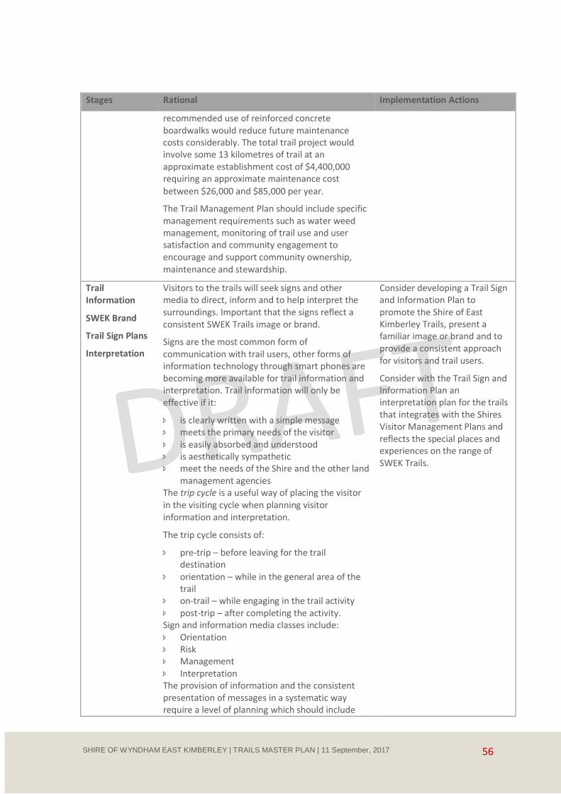
56 SHIRE OF WYNDHAM EAST KIMBERLEY | TRAILS MASTER PLAN | 11 September, 2017
Stages Rational Implementation Actions
recommended use of reinforced concrete boardwalks would reduce future maintenance costs considerably. The total trail project would involve some 13 kilometres of trail at an approximate establishment cost of $4,400,000 requiring an approximate maintenance cost
between $26,000 and $85,000 per year.
The Trail Management Plan should include specific management requirements such as water weed management, monitoring of trail use and user satisfaction and community engagement to encourage and support community ownership, maintenance and stewardship.
Trail Information
SWEK Brand
Trail Sign Plans
Interpretation
Visitors to the trails will seek signs and other media to direct, inform and to help interpret the surroundings. Important that the signs reflect a consistent SWEK Trails image or brand.
Signs are the most common form of communication with trail users, other forms of information technology through smart phones are becoming more available for trail information and interpretation. Trail information will only be effective if it:
is clearly written with a simple message meets the primary needs of the visitor is easily absorbed and understood is aesthetically sympathetic meet the needs of the Shire and the other land
management agencies The trip cycle is a useful way of placing the visitor in the visiting cycle when planning visitor information and interpretation.
The trip cycle consists of:
pre-trip – before leaving for the trail destination
orientation – while in the general area of the trail
on-trail – while engaging in the trail activity post-trip – after completing the activity. Sign and information media classes include: Orientation Risk Management Interpretation The provision of information and the consistent presentation of messages in a systematic way require a level of planning which should include
Consider developing a Trail Sign and Information Plan to promote the Shire of East Kimberley Trails, present a familiar image or brand and to provide a consistent approach for visitors and trail users.
Consider with the Trail Sign and Information Plan an interpretation plan for the trails that integrates with the Shires Visitor Management Plans and reflects the special places and experiences on the range of SWEK Trails.
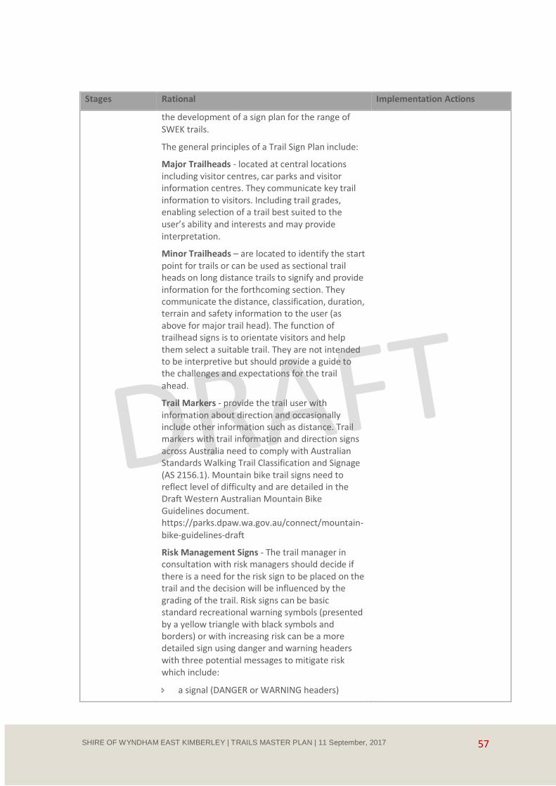
57 SHIRE OF WYNDHAM EAST KIMBERLEY | TRAILS MASTER PLAN | 11 September, 2017
Stages Rational Implementation Actions
the development of a sign plan for the range of
SWEK trails.
The general principles of a Trail Sign Plan include:
Major Trailheads - located at central locations including visitor centres, car parks and visitor information centres. They communicate key trail information to visitors. Including trail grades, enabling selection of a trail best suited to the user’s ability and interests and may provide interpretation.
Minor Trailheads – are located to identify the start point for trails or can be used as sectional trail heads on long distance trails to signify and provide information for the forthcoming section. They communicate the distance, classification, duration, terrain and safety information to the user (as above for major trail head). The function of trailhead signs is to orientate visitors and help them select a suitable trail. They are not intended to be interpretive but should provide a guide to the challenges and expectations for the trail
ahead.
Trail Markers - provide the trail user with information about direction and occasionally include other information such as distance. Trail markers with trail information and direction signs across Australia need to comply with Australian Standards Walking Trail Classification and Signage (AS 2156.1). Mountain bike trail signs need to reflect level of difficulty and are detailed in the Draft Western Australian Mountain Bike Guidelines document. https://parks.dpaw.wa.gov.au/connect/mountain-
bike-guidelines-draft
Risk Management Signs - The trail manager in consultation with risk managers should decide if there is a need for the risk sign to be placed on the trail and the decision will be influenced by the grading of the trail. Risk signs can be basic standard recreational warning symbols (presented by a yellow triangle with black symbols and borders) or with increasing risk can be a more detailed sign using danger and warning headers with three potential messages to mitigate risk which include:
a signal (DANGER or WARNING headers)

58 SHIRE OF WYNDHAM EAST KIMBERLEY | TRAILS MASTER PLAN | 11 September, 2017
Stages Rational Implementation Actions
a statement of the exact nature of the risk
how to avoid the risk (optional
Interpretive planning - for the SWEK Trails should fit within the Shire’s business, marketing or visitor management plans. It is recommended that a SWEK Trails interpretation plan should include:
What are the objectives or what the interpretation seeks to achieve?
Who should be involved in the interpretive process?
What are you interpreting?
Who are you interpreting for?
What stories do you want to tell?
What media will you use?
How will your interpretation be implemented?
How will it be monitored and evaluated?
How will it be maintained?

59 SHIRE OF WYNDHAM EAST KIMBERLEY | TRAILS MASTER PLAN | 11 September, 2017
Appendix A. Useful Links Walking Trail Classification Guide
https://parks.dpaw.wa.gov.au/sites/default/files/docs/activities/users-guide-walks-classification-
standards.pdf
draft Western Australian Mountain Bike Management Guidelines
https://parks.dpaw.wa.gov.au/connect/mountain-bike-guidelines-draft
Walking Trail Standards
https://infostore.saiglobal.com/store/PreviewDoc.aspx?saleItemID=294324