SHELLFISH HARVESTING AREA CLASSIFICATION...
51
DACS-P-01773 SHELLFISH HARVESTING AREA CLASSIFICATION MAPS Revised February, 2012 Florida Department of Agriculture & Consumer Services Division of Aquaculture Shellfish Environmental Assessment Section 1203 Governors Square Boulevard, 5th Floor Tallahassee, Florida 32301 850/488-5471, Suncom 278-5471
Transcript of SHELLFISH HARVESTING AREA CLASSIFICATION...

DACS-P-01773
SHELLFISHHARVESTING
AREACLASSIFICATION
MAPS
Revised February, 2012
Florida Department of Agriculture & Consumer Services Division of Aquaculture
Shellfish Environmental Assessment Section 1203 Governors Square Boulevard, 5th Floor
Tallahassee, Florida 32301 850/488-5471, Suncom 278-5471

PREFACE(Revised: July 6, 2007)
This document, SHELLFISH HARVESTING AREA CLASSIFICATION MAPS, illustrates classification boundaries of shellfish harvesting areas in Florida. Each shellfish harvesting area and shellfish harvesting area map has a unique name and area number. Shellfish areas are classified by the Florida Department of Agriculture and Consumer Services (DACS) to protect shellfish consumers from shellfish borne illnesses and to maximize the harvest of shellfish resources. Shellfish are defined in this context as oysters, clams and mussels. The Department is authorized by Chapter 597.020, Florida Statutes to establish regulations, specifications, and codes relating to sanitary practices for catching, handling, processing, preserving, canning, smoking, and storing of shellfish. Criteria for classification are contained in Chapter 5L-1, Florida Administrative Code (FAC), which incorporates by reference the National Shellfish Sanitation Program (NSSP) Model Ordinance. The NSSP is a voluntary and cooperative program that is designed to prevent human illness associated with the consumption of fresh and fresh-frozen shellfish through the sanitary control over all phases of growing, harvesting, shucking, packing and transportation. Participants in the NSSP include the U.S. Food and Drug Administration (FDA), U.S. Environmental Protection Agency, National Marine Fisheries Service, coastal producing and receiving states, and the shellfish industry. Only shellfish products harvested from areas that are classified and managed by a state in accordance with the NSSP are approved for harvest. Classifications are based on pollution source, hydrographic, meteorologic and bacteriological surveys to identify where sanitary conditions are suitable for the harvest of wholesome shellfish. Pollution source, hydrographic, and meteorologic surveys characterize the introduction and distribution of contaminants that may be present in amounts that present a health hazard; hence, should not be open to harvest. The bacteriological survey identifies waters meeting NSSP fecal coliform standards. Fecal coliform is an indicator group of bacteria used by DACS. Fecal coliform live in the intestinal tract of warm-blooded animals, and each person excretes approximately two billion of these bacteria per day. Few fecal coliform are pathogenic; however, the presence of fecal coliform bacteria in coastal waters indicates feces from warm-blooded animals is present and human pathogens are likely to also be present. The NSSP has established bacteriological standards for shellfish harvesting area classification. For areas to be classified Approved or Conditionally Approved, the level of fecal coliform in surface water samples must meet the NSSP 14/43 standard. For areas to be classified Restricted or Conditionally Restricted, the level of fecal coliform in surface water samples must meet the NSSP 88/260 standard.
NSSP 14/43 standard: The fecal coliform median or geometric mean must not exceed 14 MPN/100 ml, and not more than 10 percent may exceed 43 MPN/100 ml.
NSSP 88/260 standard: The fecal coliform median or geometric mean must not exceed 88 MPN/100 ml, and not more than 10 percent may exceed 260 MPN/100 ml.
A comprehensive shellfish harvesting area survey is written for each shellfish harvesting area to document the methods and findings of these surveys, as well as proposed changes in classification and management. NSSP guidelines require that these reports, at a minimum, be maintained annually, reevaluated every three years and resurveyed every 12 years. Areas that do not comply with sanitary requirements are immediately reclassified or closed. Shellfish harvesting areas are classified as Approved, Conditionally Approved, Restricted, Conditionally Restricted, Prohibited and Unclassified (= Unapproved). These classifications are defined in Chapter 5L-1.003. The following provides generalized descriptions for these classifications:
Approved Area Normally open to shellfish harvesting; may be temporarily closed under extraordinary circumstances such as red tides, hurricanes and sewage spills. The 14/43 standard must be met for all combinations of defined adverse pollution conditions (tide, rainfall, river, tide/rainfall, tide/river and tide/rainfall/river).
Conditionally Approved Area Periodically closed to shellfish harvesting based on pollution events, such as rainfall or increased river flow. The 14/43 standard must be met when rainfall, river

stage, and/or river discharge is less than the management plan level for temporary closure and during all other adverse pollution conditions.
Restricted Area Normally open to relaying or controlled purification, allowed only by special permit and supervision; may be temporarily closed under extraordinary circumstances such as red tides, hurricanes and sewage spills. The 88/260 standard must be met for all combinations of defined adverse pollution conditions (tide, rainfall, river, tide/rainfall, tide/river and tide/rainfall/river).
Conditionally Restricted Area Periodically, relay and controlled purification activity is temporarily suspended based on pollution events, such as rainfall or increased river flow. The 88/260 standard must be met when rainfall, river stage, and/or river discharge is less than the management plan level for temporary closure and during all other adverse pollution conditions.
Prohibited Shellfish harvesting is not permitted due to actual or potential pollution. This classification is least desirable, and is used only when standards are exceeded for Approved, Conditionally Approved, Restricted and Conditionally Restricted classification management schemes.
Unclassified Shellfish harvesting is not permitted pending bacteriological and sanitary surveys.
The verbal descriptions of shellfish harvesting areas are presented in this document from the northwesternmost shellfish harvesting area located in Escambia and Santa Rosa Counties counterclockwise along the coastline of Florida to the northeasternmost shellfish harvesting area located in Duval County. Surface waters that lack a map in this document for shellfish harvesting area boundaries are Unclassified. Harvest of shellfish from these Unclassified waters is not lawful (Chapter 5L-1.003(7)), because the current sanitary conditions of the area have not been characterized for the protection of the health of shellfish consumers. Counties where all coastal waters classified as Unclassified are: Jefferson, Taylor, Hernando, Pasco, Monroe, Dade, Broward, Palm Beach, Martin, Flagler, and Nassau. Shellfish harvesting areas may be in the open or closed status. Harvesting of shellfish from an area in the closed status is not permitted [Chapter 5L-1.003(2)(b), .003(3), .003(4), and .003(5), FAC]. Closed areas include prohibited and unclassified areas as well as temporarily closed approved, conditionally approved, restricted, and conditionally restricted areas. The open/closed status of shellfish harvesting areas is available from the field and headquarter offices of the DACS Shellfish Environmental Assessment Section. Verbal descriptions of classification boundaries and management of shellfish harvesting areas are available from the Department. The locations and phone numbers of offices of the DACS Shellfish Environmental Assessment Section are presented below.
Headquarters 1203 Governors Square Boulevard, 5th Floor, Tallahassee 32301 850/488-4033, 488-5473, FAX 850/410-0893
Western Gulf Coast 4408 Delwood Lane, Panama City Beach, FL 32408 850/236-2200, FAX 850/236-2202
North Central Gulf Coast 260 7th Street, Apalachicola, FL 32320 850/653-8317/9440, FAX 850/653-4735
Big Bend Gulf Coast Cedar Key Field Station, 11350 SW 153rd Court, Cedar Key, FL 32625 352/543-5181, FAX 352/543-6958
Southern Gulf Coast Riverside Commercial Park, 25418 East Marion Ave, Unit #1, Space A, Punta Gorda, FL 33950, 941-833-2552, FAX 941-833-2553
Atlantic Coast 1220 Prospect Ave, Suite 216, Melbourne, FL 32901 321/984-4890, FAX 321/984-4892

INDEX OF SHELLFISH HARVESTING AREA CLASSIFICATION MAPS, BOUNDARIES AND MANAGEMENT PLANS
Revised February, 2012
Shellfish Harvesting Area Name Area Number Map Number(s) Effective Date
Apalachicola Bay System 16 16A, 16B February 9, 2011 Alligator Harbor 18 18 August 2012 Boca Ciega Bay 42 42 May 5, 2009
Body A 80 80 May 5, 2009 Body B 78 78 May 5, 2009 Body C 77 77A, 77B May 5, 2009 Body D 76 76 May 5, 2009 Body E 75 75 May 5, 2009 Body F 74 74 May 5, 2009
Cedar Key 30 30 May 5, 2009 Choctawhatchee Bay 06 06 May 5, 2009
Citrus County 37 37A, 37B May 5, 2009 Duval County 96 96 May 5, 2009
East Bay 12 12 May 5, 2009 Gasparilla Sound 58 58 May 5, 2009 Horseshoe Beach 25 25A, 25B May 5, 2009
Indian Lagoon 15 15A, 15B May 5, 2009 Indian River/St. Lucie Counties 70 70 May 5, 2009
Lemon Bay 56 56 May 5, 2009 Lower Tampa Bay 48 48 May 5, 2009
Myakka River 60 60 August, 2012 North Bay 10 10 May 5, 2009
North Indian River 72 72 May 5, 2009 North St. Johns 92 92 May 5, 2009
Ochlockonee Bay 20 20 May 5, 2009 Pensacola Bay System 02 02 May 5, 2009
Pine Island Sound 62 62 May 5, 2009 Sarasota Bay 54 54 May 5, 2009
South Banana River 79 79 December 28, 2009 South St. Johns 88 88 December 28, 2009 South Volusia 82 82A, 82B August, 2012 St. Joseph Bay 14 14 November 1986
St. Marks 23 23 June 18, 2009 Suwannee Sound 28 28 A, 28 B May 5, 2009
Ten Thousand Islands 66 66 May 5, 2009 Waccasassa Bay 32 32 May 5, 2009 Wakulla County 22 22A, 22B May 5, 2009
West Bay 08 08 August, 2012 Withlacoochee Bay 34 34 May 5, 2009

Curr
ent S
tatu
s of
this
are
a
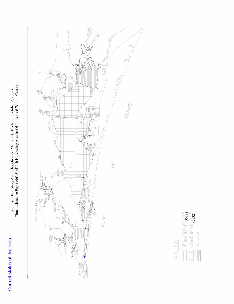
(062
2)
(063
2)
Sh
ellfi
sh H
arve
stin
g A
rea
Cla
ssifi
catio
n M
ap #
06 (E
ffec
tive:
O
ctob
er 2
, 200
7)
Cho
ctaw
hatc
hee
Bay
(#06
) She
llfis
h H
arve
stin
g A
rea
in O
kalo
osa
and
Wal
ton
Cou
nty
Cur
rent
sta
tus
of th
is a
rea

Aug
ust 2
012
)

(1006) EASTERN SECTION
SHELLFISH HARVESTING AREA CLASSIFICATION MAP #10 (Effective: August 17, 2004) North Bay (#10) Shellfish Harvesting Area in Bay County
Current status of this area

SH
ELL
FIS
H H
AR
VE
STI
NG
AR
EA
CLA
SS
IFIC
ATI
ON
MA
P #
12 (E
ffect
ive:
Jun
e 11
, 200
6)
Eas
t Bay
(#1
2) S
hellf
ish
Har
vest
ing
Are
a in
Bay
Cou
nty
Cur
rent
sta
tus
of th
is a
rea

Current status of area

IND
IAN
ST. V
INCE
NT
SOU
ND
ST. V
INCE
NT
ISLA
ND
INDIA
N PASS
PEN
NIS
ULA
TOW
ER
IND
IAN
LAG
OO
N
SEMINOLE STREET
RA
DIO
GU
LF
OF
MEX
ICO
CA
MP
PALM
UV30A
UV30B
00.
51
0.25
Mile
s
·Sp
ring
/Fal
l Har
vest
Are
a
Con
ditio
nally
App
rove
d (1
512)
Pro
hibi
ted
This
pro
duct
, pro
duce
d by
Flo
rida
Dep
artm
ent o
f Agr
icul
ture
and
Con
sum
er S
ervi
ces,
Div
isio
n of
Aqu
acul
ture
, is
for i
nfor
mat
iona
l pur
pose
s an
d m
ay n
ot h
ave
been
pr
epar
ed fo
r, or
be
suita
ble
for l
egal
, eng
inee
ring,
or s
urve
ying
pur
pose
s. U
sers
of th
is in
form
atio
n sh
ould
revi
ew o
r con
sult
the
prim
ary
data
and
info
rmat
ion
sour
ces
to a
scer
tain
the
usab
ility
of t
he in
form
atio
n.
SHE
LLFI
SH
HA
RV
EST
ING
AR
EA C
LAS
SIF
ICAT
ION
MAP
#15
B (E
ffect
ive:
Sep
tem
ber 5
, 200
5)In
dian
Lag
oon
(#15
) She
llfis
h H
arve
stin
g Ar
ea in
Gul
f Cou
nty
Sprin
g/Fa
ll M
onth
s: M
arch
- Ju
ne; O
ctob
er
C:\G
IS\S
hellf
ish\
ceng
ulf\m
aps\
indl
ag.m
xd R
ev. 0
3/11
FIN
AL
Curr
ent s
tatu
s of
this
are
a

IND
IAN
ST. V
INCE
NT
SOU
ND
ST. V
INCE
NT
ISLA
ND
INDIA
N PASS
PEN
NIS
ULA
TOW
ER
IND
IAN
LAG
OO
N
SEMINOLE STREET
RA
DIO
GU
LF
OF
MEX
ICO
CA
MP
PALM
UV30A
UV30B
00.
51
0.25
Mile
s
·W
inte
r H
arve
st A
rea
Con
ditio
nally
App
rove
d W
inte
r Zon
e A
(154
2)
Con
ditio
nally
App
rove
d W
inte
r Zon
e B
(155
2)
Con
ditio
nally
Res
trict
ed W
inte
r(15
06)
Pro
hibi
ted
This
pro
duct
, pro
duce
d by
Flo
rida
Dep
artm
ent o
f Agr
icul
ture
and
Con
sum
er S
ervi
ces,
Div
isio
n of
Aqu
acul
ture
, is
for i
nfor
mat
iona
l pur
pose
s an
d m
ay n
ot h
ave
been
pr
epar
ed fo
r, or
be
suita
ble
for l
egal
, eng
inee
ring,
or s
urve
ying
pur
pose
s. U
sers
of th
is in
form
atio
n sh
ould
revi
ew o
r con
sult
the
prim
ary
data
and
info
rmat
ion
sour
ces
to a
scer
tain
the
usab
ility
of t
he in
form
atio
n.
C:\G
IS\S
hellf
ish\
ceng
ulf\m
aps\
indl
ag.m
xd R
ev. 0
3/11
FIN
AL
SHE
LLFI
SH
HA
RV
EST
ING
AR
EA C
LAS
SIF
ICAT
ION
MAP
#15
A (E
ffect
ive:
Sep
tem
ber 5
, 200
5)In
dian
Lag
oon
(#15
) She
llfis
h H
arve
stin
g Ar
ea in
Gul
f Cou
nty
Win
ter M
onth
s: N
ovem
ber -
Feb
ruar
yCu
rren
t sta
tus
of th
is a
rea
IND
IAN
ST.
VIN
CE
NT
ISL
AN
D
CA
BB
AG
ETO
P
FO
RM
ER
F.H
.P.
BU
ILD
ING
ST.
SOU
ND
CR
OO
KED
RIV
ER
LIG
HT
GR
EEN
ST.
VIN
CE
NT
POIN
T
SIK
ES
CU
T
ST.
GEOR
GE
ISLA
ND
EAST
BA
YO
U
CAT
BA
YW
IMIC
O
LAKE
APA
LAC
HIC
OLA
WES
T P
ASS
EAST
POIN
TB
RE
AK
WA
TER
VIN
CE
NT
ISL
AN
DTA
NK
RED
FIS
HC
RE
EK
IND
IAN
PASS
POIN
T
ST. MA R
KS
RIV
ER
APAL AC
HIC
OL
A R IV
ER
JAC
KSO
N R
IVER
EAST
POIN
TREV
ET
ME
NT
EAST
ERN
MO
ST P
OIN
TO
F SE
AW
ALL
YE
NT
BA
YO
U
EAST
PASS
ST. G
EOR
GE
ISL
AN
DB
RID
GE
SAM
SB
AY
OU
PEN
INSU
LA
AC
CE
SS R
OA
DAT
FIV
E M
ILE
EIG
HT
MIL
EPO
INT
FER
RY
PA
SS
YA
CH
T B
AS
IN
ST. G
EORG
E SO
UND
APA
LAC
HIC
OLA
BAY
SHEE
PSH
EAD
BAYO
U
EAST
BA
Y
IND
IAN
LA
GO
ON
L ITTLE S
T. G
EO
RG
E IS
LAN
D
ISL
AN
DTO
WH
EA
D
POIN
TLO
NG
CA
MPB
ELL
POIN
T
BIG
BA
YO
U
WES
TB
AY
OU
HUCKLEBERRYCREEK
BLO
UN
TS
RIP
-RA
P
GULF
OF
MEXICO
TWO
MIL
EC
HA
NN
EL
TAT
ES H
ELL
SW
AM
P
JOH
N G
OR
RIE
MEM
OR
IAL
BR
IDG
E
¬«30A
¬«376
¬«384A
¬«67A
¬«376
¬«384
¬«384
¬«30B
¬«65
¬«379
¬«384
¬«382
¬«30A
¬«384
¬«65
¬«30A
¬«300
¬«71
¬«30
¬«65
¬«30
This
pro
duct
, pro
duce
d by
Flo
rida
Dep
artm
ent o
f Agr
icul
ture
and
Con
sum
er S
ervi
ces,
Div
isio
n of
Aqu
acul
ture
, is
for i
nfor
mat
iona
l pur
pose
s an
d m
ay n
ot h
ave
been
pre
pare
d fo
r, o
r be
suita
ble
for l
egal
, eng
inee
ring,
or
surv
eyin
g pu
rpos
es. U
sers
of t
his
info
rmat
ion
shou
ld r
evie
w o
r con
sult
the
prim
ary
data
and
info
rmat
ion
sour
ces
to a
scer
tain
the
usab
ility
of t
he in
form
atio
n.
SHE
LLFI
SH
HA
RV
ESTI
NG
AR
EA
CLA
SS
IFIC
ATIO
N M
AP #
16A
(Effe
ctiv
e: F
ebru
ary
9, 2
011)
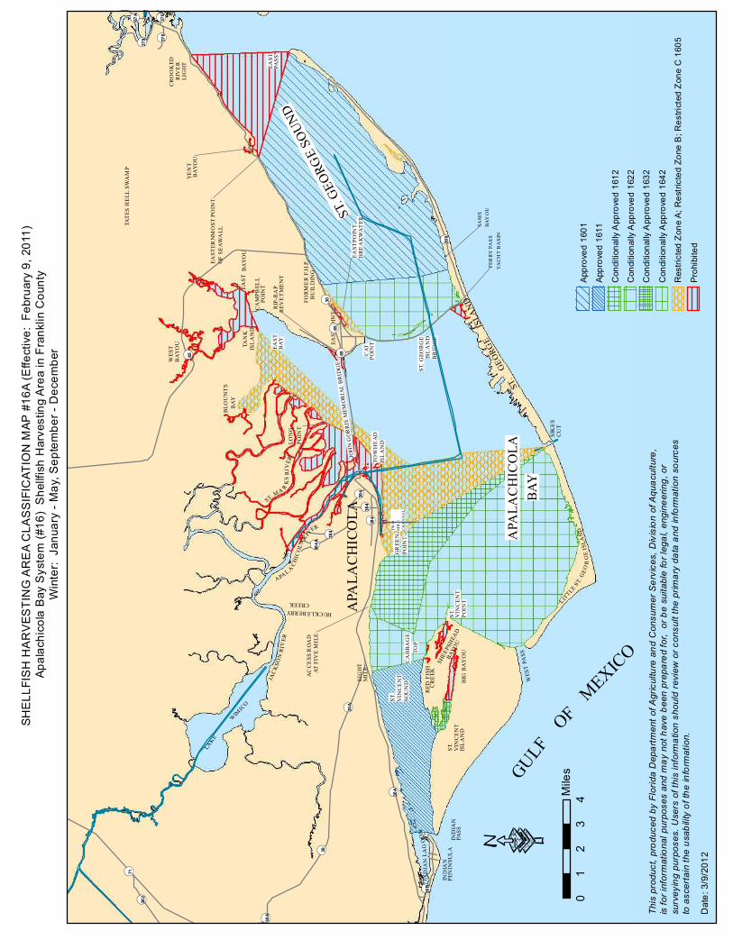
Ap
alac
hico
la B
ay S
yste
m (#
16)
She
llfis
h H
arve
stin
g A
rea
in F
rank
lin C
ount
yW
inte
r: J
anua
ry -
May
, Sep
tem
ber -
Dec
embe
r
01
23
4Mile
sA
ppro
ved
1601
App
rove
d 16
11
Con
ditio
nally
App
rove
d 16
12
Con
ditio
nally
App
rove
d 16
22
Con
ditio
nally
App
rove
d 16
32
Con
ditio
nally
App
rove
d 16
42
Res
trict
ed Z
one
A; R
estr
icte
d Zo
ne B
; Res
trict
ed Z
one
C 1
605
Pro
hibi
ted
Dat
e: 3
/9/2
012·

IND
IAN
ST.
VIN
CE
NT
ISL
AN
D
CA
BB
AG
ETO
P
FOR
ME
R F
HP
BU
ILD
ING
ST.
SOU
ND
CR
OO
KED
RIV
ER
LIG
HT
GR
EEN
ST.
VIN
CE
NT
POIN
T
SIK
ES
CU
T
ST.
GEOR
GE
ISLA
ND
EAST
BA
YO
U
CAT
BA
YW
IMIC
O
LAKE
APA
LAC
HIC
OLA
WES
T P
ASS
EAST
POIN
TB
RE
AK
WA
TER
VIN
CE
NT
ISL
AN
DTA
NK
RED
FIS
HC
RE
EK
IND
IAN
PASS
POIN
T
ST. MA R
KS
RIV
ER
APAL AC
HIC
OL
A RIV
ER
JAC
KSO
N R
I VE R
EAST
POIN
TREV
ET
ME
NT
EAST
ERN
MO
ST P
OIN
TO
F SE
AW
ALL
YE
NT
BA
YO
U
EAST
PASS
ST. G
EOR
GE
ISL
AN
DB
RID
GE
SAM
SB
AY
OU
PEN
INSU
LA
AC
CE
SS R
OA
DAT
FIV
E M
ILE
EIG
HT
MIL
EPO
INT
FER
RY
PA
SS
YA
CH
T B
AS
IN
ST. G
EORG
E SO
UND
APA
LAC
HIC
OLA
BAY
SHEE
PSH
EAD
BAYO
U
EAST
BA
Y
IND
IAN
LA
GO
ON
LITTLE S
T. G
EO
RG
E IS
LAN
D
ISL
AN
DTO
WH
EA
D
POIN
TLO
NG
CA
MPB
ELL
POIN
T
BIG
BA
YO
U
WES
TB
AY
OU
HUCKLEBERRYCREEK
BLO
UN
TS
RIP
-RA
P
GULF
OF
MEXICO
TWO
MIL
EC
HA
NN
EL
TAT
ES H
ELL
SW
AM
P
JOH
N G
OR
RIE
MEM
OR
IAL
BR
IDG
E
¬«30A
¬«376¬«67A
¬«376
¬«384
¬«384
¬«30B
¬«387
¬«379
¬«384
¬«382
¬«30A
¬«384
¬«65
¬«30A
¬«300
¬«71
¬«30
¬«65
¬«30
C:\G
IS\S
hellf
ish\
ceng
ulf\m
aps\
apal
achi
cola
.mxd
Rev
. 01/
11 F
INA
L
This
pro
duct
, pro
duce
d by
Flo
rida
Dep
artm
ent o
f Agr
icul
ture
and
Con
sum
er S
ervi
ces,
Div
isio
n of
Aqu
acul
ture
, is
for i
nfor
mat
iona
l pur
pose
s an
d m
ay n
ot h
ave
been
pre
pare
d fo
r, o
r be
suita
ble
for l
egal
, eng
inee
ring,
or
surv
eyin
g pu
rpos
es. U
sers
of t
his
info
rmat
ion
shou
ld r
evie
w o
r con
sult
the
prim
ary
data
and
info
rmat
ion
sour
ces
to a
scer
tain
the
usab
ility
of t
he in
form
atio
n.
·
SHE
LLFI
SH
HA
RV
ESTI
NG
AR
EA
CLA
SS
IFIC
ATIO
N M
AP
#16
B (E
ffect
ive:
Feb
ruar
y 9,
201
1)Ap
alac
hico
la B
ay S
yste
m (#
16)
She
llfis
h H
arve
stin
g A
rea
in F
rank
lin C
ount
ySu
mm
er J
une
- Aug
ust
App
rove
d 16
21
App
rove
d 16
71
Con
ditio
nally
App
rove
d 16
52
Con
ditio
nally
App
rove
d 16
62
Res
trict
ed Z
one
C; R
estr
icte
d Zo
ne B
; Res
tric
ted
Zon
e A
1605
Pro
hibi
ted
02
41
Mile
s

Aug
ust 2
012
)

Cur
rent
sta
tus
of th
is a
rea

COVE
FIDDLERS
OCHLOCKONEE
ULLMORE
LANDING
LONGLAKE
PORTER
ISLAND
BAYLEVY
COVEOYSTER
POINT
DICKERSONBAY
CREEKSKIPPER
LAKEALLIGATOR
MEDART
CREEK
STOKLEY
PURIFY
POINT
ISLANDPINEY
SMITHISLAND
REDFISH
SHELLPOINT
CREEK
CREEKSPRING
ISLANDBOGGY
GRASSINLET
OAKLIVE
ISLANDCUTOFF
HOPKINSISLAND
MASHES
ROCKCREEK
LIGHTEDMARKER
OLDCREEK
PANACEA
APALACHEE BAY
GULFOF
MEXICO
OYSTER BAY
ISLANDPALMETTO
ISLANDGULL
SPRINGCREEK
CHANNEL
CHANNEL
SHELLPOINT
ISLAND
OCHLOCKONEE
BAY
ISLANDSANDS
CUTOFFCREEK
EVANSCREEK
HUNGRYPOINT
PANACEA
CHANNEL
98
372
367
365
375
367A
372A
370
375
372A
SHELLFISH HARVESTING AREA CLASSIFICATION MAP #22B (Effective: August 17, 2004)Wakulla County (#22) Shellfish Harvesting Area in Wakulla County
Spring Months: April – May, September
0 1 20.5Miles
Conditionally Approved Zone 1(2232)
Conditionally Approved Zone 2(2242)
Conditionally Restricted(2206)
Prohibited
This product, produced by Florida Department of Agriculture andConsumer Services, Division of Aquaculture, is for nformational purposes and may not have been prepared for, or be suitable for legal, engineering, or surveying purposes. Users of this information should review or consult the primary data and information sources to ascertain the usability of the information.C:\GIS\Shellfish\cengulf\maps\WAKULLA.mxd 04/23/09 FINAL
Current status of this area
COVE
FIDDLERS
OCHLOCKONEE
ULLMORE
LANDING
LONGLAKE
PORTER
ISLAND
BAYLEVY
COVEOYSTER
POINT
DICKERSONBAY
CREEKSKIPPER
LAKEALLIGATOR
MEDART
CREEK
STOKLEY
PURIFY
POINT
ISLANDPINEY
SMITHISLAND
REDFISH
SHELLPOINT
CREEK
CREEKSPRING
ISLANDBOGGY
GRASSINLET
OAKLIVE
ISLANDCUTOFF
HOPKINSISLAND
MASHES
ROCKCREEK
LIGHTEDMARKER
OLDCREEK
PANACEA
APALACHEE BAY
GULFOF
MEXICO
OYSTER BAY
ISLANDPALMETTO
ISLANDGULL
SPRINGCREEK
CHANNEL
CHANNEL
SHELLPOINT
ISLAND
OCHLOCKONEE
BAY
ISLANDSANDS
CUTOFFCREEK
EVANSCREEK
HUNGRYPOINT
PANACEA
CHANNEL
98
372
367
365
375
367A
372A
370
375
372A
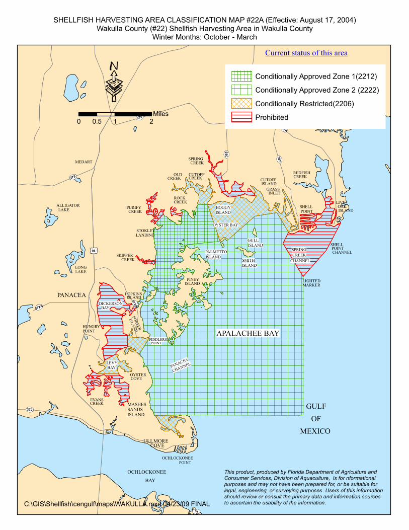
SHELLFISH HARVESTING AREA CLASSIFICATION MAP #22A (Effective: August 17, 2004)Wakulla County (#22) Shellfish Harvesting Area in Wakulla County
Winter Months: October - March
0 1 20.5Miles
Conditionally Approved Zone 1(2212)
Conditionally Approved Zone 2 (2222)
Conditionally Restricted(2206)
Prohibited
This product, produced by Florida Department of Agriculture andConsumer Services, Division of Aquaculture, is for nformational purposes and may not have been prepared for, or be suitable for legal, engineering, or surveying purposes. Users of this information should review or consult the primary data and information sources to ascertain the usability of the information.C:\GIS\Shellfish\cengulf\maps\WAKULLA.mxd 04/23/09 FINAL
Current status of this area

Current status of area

SH
ELL
FIS
H HA
RV
ES
TIN
G A
REA
CLASS
IFICA
TIO
N MA
P #25A
(Effe
ctiv
e: S
eptem
ber 2
8, 2
004)
H
orse
shoe
Bea
ch (#25
) She
llfis
h Har
vest
ing A
rea
in D
ixie
Cou
nty
Summ
er M
onth
s: A
pril
– S
eptem
ber
Cur
rent
sta
tus
of th
is a
rea

SH
ELL
FIS
H H
AR
VE
STI
NG
AR
EA
CLA
SS
IFIC
ATI
ON
MA
P #
25B
(Effe
ctiv
e: S
epte
mbe
r 28,
200
4)
Hor
sesh
oe B
each
(#25
) She
llfis
h H
arve
stin
g A
rea
in D
ixie
Cou
nty
Win
ter M
onth
s: O
ctob
er –
Mar
ch
Cur
rent
sta
tus
of th
is a
rea

SHELLFISH HARVESTING AREA CLASSIFICATION MAP #28A (Effective: March 11, 2007) Suwannee Sound (#28) Shellfish Harvesting Area in Dixie and Levy Counties
Winter months: October-January
Current status of this area

SHELLFISH HARVESTING AREA CLASSIFICATION MAP #28B (Effective: March 11, 2007) Suwannee Sound (#28) Shellfish Harvesting Area in Dixie and Levy Counties
Spring/Summer Months: February – May, September
Current status of this area

SHELLFISH HARVESTING AREA CLASSIFICATION MAP #30 (Effective: September 28, 2004) Cedar Key (#30) Shellfish Harvesting Area in Levy County
Current status of this area

SH
ELLF
ISH
HA
RV
ES
TIN
G A
RE
A C
LA
SS
IFIC
AT
ION
MA
P #
32 (
Effective: S
epte
mber
28, 2004)
Waccasassa B
ay (
#32)
Shellf
ish H
arv
esting A
rea in L
evy C
ounty
Cur
rent
sta
tus
of th
is a
rea

SHELLFISH HARVESTING AREA CLASSIFICATION MAP #34 (Effective: September 28, 2004) Withlacoochee Bay (#34) Shellfish Harvesting Area in Levy and Citrus Counties
Current status of this area

SHELLFISH HARVESTING AREA CLASSIFICATION MAP #37A Citrus County (#37) Shellfish Harvesting Area in Citrus County
Spring / Fall Months: March thru June and October (Effective: July 28, 2008)
Current status of this area

SHELLFISH HARVESTING AREA CLASSIFICATION MAP #37B Citrus County (#37) Shellfish Harvesting Area in Citrus County
Winter Months: November thru February (Effective: July 28, 2008)
Current status of this area

Current status of the area

SH
ELLF
ISH
HA
RV
ES
TIN
G A
RE
A C
LA
SS
IFIC
AT
ION
MA
P #
48 (
Effective: S
epte
mber
28, 2004)
Low
er
Tam
pa B
ay (
#48)
Shellf
ish H
arv
esting A
rea in M
anate
e a
nd H
illsboro
ugh C
ounties
Cur
rent
sta
tus
of th
is a
rea

SHELLFISH HARVESTING AREA CLASSIFICATION MAP #54 (Effective: September 28, 2004) Sarasota Bay (#54) Shellfish Harvesting Area in Sarasota and Manatee Counties
Current status of this area

$
$
$
$
$
$
$
$
$
$
$
$
$
#
$
$
$
$
$
LEMON BAY
BIRDKEY
OYSTERCREEK
ROCKCREEK
GOTTFRIEDCREEK
WESTBRANCH
EASTBRANCH
MYAKKA
RIV
ER
LEMON CREEK
BUCKCREEK
GULF OFMEXICO
CORA
L
CREEK
GASPARILLA PASS
GASPARILLAISLAND
KNIGHTISLAND
THORNTONKEY
WHIDDENKEY
ISLANDDON PEDRO
PETERSONISLAND
GASPARILLAISLAND
LITTLE
KEYCOON
STUMP
PASS
ENGLEWOODBEACH
NO WAKESIGN
MANASOTAKEY
FORKEDCREEK
FERRYHIDEAWAY
DOCK
COLEISLAND
5
4
22
13
10
25
24
27
9A
24
36
40
30A
24A
19A
28A
POST
UV775
UV776
UV771
UV777
UV775A
UV774
UV775
Conditionally Approved (5602)
Prohibited
C:\GIS\Shellfish\southgulf\maps\56_class.mxd Rev. 1/11
·0 1 20.5
Miles
SHELLFISH HARVESTING AREA CLASSIFICATION MAP #56 (Effective: July 20, 1998)
Lemon Bay (#56) Shellfish Harvesting Area in Charlotte and Sarasota Counties

(5802)
SHELLFISH HARVESTING AREA CLASS IFICATION MAP #58 (E ffective: January 25, 1996)
Gasparilla Sound (#58) Shellfish Harvesting Area in Charlotte and Lee Counties
Current status of this area

August 2012 )

$
$
$$
$$
$
$
$$
$$
$$
$
$
$
$
$
$
%
%
$
$
$
$
$
$
REDFISHPASS
CAYOCOSTA
CAPTIVAPASS
CAPTIVAISLAND
BUCKKEY
SANIBEL
ISLAND
PINE ISLA
ND
LITTLE
MERWINKEY
FISHERMANKEY
SAN CARLOS BAY
TARPON
MASTERS
USEPPAISLAND
PINE
BAY
CAPE CORAL
BOK EELIAISLA ND
BOKEELIA
LANDING
NORTHCAPTIVAISLAND
POINTJU G CREEK
ISLA ND
PASSBLIND
ISLAND
PRIMOPOINT
LIT
TL
E PIN
E ISLA
ND
CR
EE
K
ST. JA
ME
S C
RE
EK
LITTLE
PATRICIO
JO SSLYN
ISLA NDCALU SA
ISLA ND
PUNTABLAN CO
KEYWOODLITTLE
ISLA NDANHIN GA
PAN THERKEYS
PINE ISLA
ND
SOU
ND
CHADWICKBAYOU
ISLANDREGLA
RECKEMSPOINT
RAGISLA ND
MANATEE
65 DE GREES TRUE
KEYINDIAN
ISLA ND
SWO RD
KEYBIG SISTER
PINEY
PUNTABLANCABAY
IONA
BAY
YORKISLAND
LONGPOINT
BAY
LITTLEBOKEELIA
CALOOSAHATCHEERIVER
POINT
POINT
POINT
ISLAND
ISLAND
ISLANDPART
BIGISLAND
NARROWSKEY
DEMERE
KEY
ISLANDGALT
MATLA
CH
A PASS
GULF
MEXICO
CHARLOTTE HARBOR
SHELLPOINT
OF
UV767
UV765
UV78
UV 771
8
8
5
1 4
27
25
37
74
52
51
23
29
33
48
62
75
34
8A40
44
50
5758
67
75
NE MARKER LEASE LE 110
SE MARKER LEASE LE 119
·
SHELLFISH HARVESTING AREA CLASSSIFICATION MAP #62 (Effective: December 28, 1998)Pine Island Sound (#62) Shellfish Harvesting Area in Lee County
0 1 2 3 4Miles
This product, produced by Florida Department of Agriculture and Consumer Services, Division of Aquaculture, is for informational purposes and may not have been prepared for, or be suitable forlegal, engineering, or surveying purposes. Users of this informationshould review or consult the primary data and information sourcesto ascertain the usability of the information.
C:\GIS\Shellfish\southgulf\maps\pineisland_sound\62_class_poly.mxd FINAL 02/11
Conditionally Approved Western Section 6212
Conditionally Approved Eastern Section 6222
Prohibited

SH
ELL
FIS
H HA
RV
ES
TIN
G A
REA
CLASS
IFICA
TIO
N MA
P #66
(Effe
ctiv
e: S
eptem
ber 2
8, 2
004)
Te
n Th
ousa
nd Is
land
s (#66
) She
llfis
h Har
vest
ing A
rea
in C
ollie
r Cou
nty
Cur
rent
sta
tus
of th
is a
rea

(7001)
(7006)
SHELLFISH HARVESTING AREA CLASSIFICATION MAP #70 (Effective: June 18, 1997)Indian River/St. Lucie (#70) Shellfish Harvesting Area in Indian River and St. Lucie Counties
Current status of this area

SHELLFISH HARVESTING AREA CLASSIFICATION MAP #72 (Effective: June 18, 1997)North Indian River (#72) Shellfish Harvesting Area in Indian River County
(7202)
(7206)
Current status of this area

SHELLFISH HARVESTING AREA CLASSIFICATION MAP #74 (Effective:, April 5, 2000)Body F (#74) Shellfish Harvesting Area in Brevard County
Current status of this area
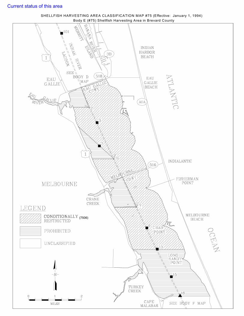
(7506)
SHELLFISH HARVESTING AREA CLASSIFICATION MAP #75 (Effective: January 1, 1994)Body E (#75) Shellfish Harvesting Area in Brevard County
Current status of this area

%
$
!
$
!
%
%
!
!
$
$
%
!
%
$
$
!
$
%
!%
$
NEW
FOU
ND
HA
RBOR
SHADYLANE
COCOA
BANANA RIVERATLA
NTIC
OC
EAN
MERRITTISLAND
ROCKLEDGE
COCOABEACH
CANAVERALCAPE
PALMSHORES
BEACH
SATELLITEBEA
CHH
ARBO
R
EAUGALLIE
SOUTHCOCOABEACH
OLD BREVARDHOTEL SEAWALL
MANGROVEISLAND
EAU GALLIE CAUSEWAY
BARGE CANALCANAVERAL
PINEDA
PLOVERPOINT
COQUINA ROAD
IND
IAN
INDIA
N RIVER LAGOO
N
BODY EMAP
SEE
SEESOUTH BANANA RIVER
MAP
PATRICKSOUTH
SEEBODY C
MAPS
BENNET CAUSEWAY
"99
"98
"95
"94
"92
"91
%90
%89%88
"86
"85
"83"81
"79
"77
"76
"73
"72
"71
"102
"101
"100
UV5
UV528
UV511
UV3
UV404
UV509
UV524
UV502
UV520
UV509 UV3
UV528
UV3
UV520 UV520
§̈¦A1A
§̈¦95
§̈¦A1A³
Conditionally Approved (7602)
Conditionally Restricted (7606)
Prohibited
0 1 2 3Miles
C:\G
IS\S
hellf
ish\
atla
ntic
\map
s\bo
dyd.
mxd
FIN
AL
06/0
2/09
This product, produced by Florida Department of Agriculture and Consumer Services, Division of Aquaculture, is for informational purposes and may not have been prepared for, or be suitable for legal, engineering, orsurveying purposes. Users of this information should review or consult the primary data and information sources to ascertain the usability of the information.
SHELLFISH HARVESTING AREA CLASSIFICATION MAP #76 (Effective August 1, 1996)Body D (#76) Shellfish Harvesting Area in Brevard CountyCurrent status of this area

SHELLFISH HARVESTING AREA CLASSIFICATION MAP #77A (Effective: January 1, 1994)Body C (#77) Shellfish Harvesting Area in Brevard County
Winter Months: December - February
(7732)
(7716)
Current status of this area

(7712)
(7722)
(7726)
SHELLFISH HARVESTING AREA CLASSIFICATION MAP #77B (Effective: January 1, 1994)Body C (#77) Shellfish Harvesting Area in Brevard County
Spring/Fall Months: March - November
Current status of this area

SHELLFISH HARVESTING AREA CLASSIFICATION MAP #78 (Effective: April 14, 2008) Body B (#78) Shellfish Harvesting Area in Brevard County
Current status of this area

COCOA
PALM SHORES
ROCKLEDGE
INDIAN HARBOUR
BEACHSATELLITE
AIR FORCEPATRICK
COCOA
BEACH
BASE
BEACH
HO
RTIPO
INT
CANAVERAL
PENINSULA
BAN
AN
A
NEW
FOU
ND
HA
RBO
R
IND
IAN
RIVER LA
GO
ON
SHELLPOINT
PARKKELLY
CREEKSYKES
MerrittIslandRegionalAirport
NesbitIsland
Federal No Motor Zone Boundary
HOUSINGPATRICK AFB
SHORTYSPOCKET
MINUTEMENPENNISULA
LONGPOINT
BIGISLAND
POINTBUCK
DRAGONPOINT
RIVER
MERRITTISLAND
ATLAN
TIC O
CEA
N
8
95
8
1
2
4
5
7
8 9
75
25
13
1112
5A
7A
6A
6B
8A
1114
15
2021
22
2324
27
28
1315
16
17
PRIVATE MARKER 127
PRIVATE MARKER 117
6
A1A
3
520
3
95
528
509
524
404
519
509
518
528
A1A
518
A1A
502
520
528
518
518
3
520
C:\GIS\Shellfish\atlantic\maps\sban.mxd FINAL 09/09
Manatee Signs
Conditionally Approved
Conditionally Restricted
Prohibited
SHELLFISH HARVESTING CLASSIFICATION AREA MAP #79 (Effective: December 28, 2009)South Banana River (#79) Shellfish Harvesting Area in Brevard County
0 1 2 3Miles
This product, produced by Florida Department of Agricultureand Consumer Services, Division of Aquaculture, is for informational purposes and may not have been prepared for,or be suitable for legal, engineering, or surveying purposes. Users of this information should review or consult the primary data and information sources to ascertain the usability of the information.
Current status of this area

MOSQUITO LAGOON
ATLANTIC
INDIAN
RIVER
DU
MM
ITCR
EEK
BOAT
HO
USE
POIN
T
TURN
BULL
CREE
K
MER
RITT
ISLA
ND
LAGOON
PELI
CAN
ISLA
ND
CAB
BAG
ETH
REE
ISLA
ND
SCO
TTSM
OR
E
OCEAN
HA
ULO
VER
CAN
AL
BRO
CKCR
EEK
GAT
OR
CREE
K
CATF
ISH
CREE
K
GRA
SSY
POIN
T
HO
ECK
MA
X
CREE
K
TITU
SVIL
LE
BLA
CK
POIN
T
95
1
3
3
406
406
540
5
402
405
46
5
29
35
43
1
8
9
12 15 17
19
2523
C:\G
IS\S
hellf
ish\
atla
ntic
\map
s\bo
dya.
mxd
5/2
0/20
10
01
23M
iles
This
pro
duct
, pro
duce
d by
Flo
rida
Dep
artm
ent o
f Agr
icul
ture
and
Con
sum
er S
ervi
ces,
Div
isio
n of
Aqu
acul
ture
, is
for i
nfor
mat
iona
lpu
rpos
es a
nd m
ay n
ot h
ave
been
pre
pare
d fo
r, or
be
suita
ble
for
lega
l, en
gine
erin
g, o
r sur
veyi
ng p
urpo
ses.
Use
rs o
f thi
s in
form
atio
n sh
ould
revi
ew o
r con
sult
the
prim
ary
data
and
info
rmat
ion
sour
ces
to a
scer
tain
the
usab
ility
of t
he in
form
atio
n.
Appr
oved
(800
1)
Res
trict
ed (8
005)
Proh
ibite
d
SHE
LLFI
SH
HAR
VES
TIN
G A
RE
A C
LAS
SIF
ICAT
ION
MAP
#80
(Effe
ctiv
e:
Dec
embe
r 28,
199
7)Bo
dy A
(#80
) She
llfis
h H
arve
stin
g A
rea
in B
reva
rd C
ount
yC
urre
nt s
tatu
s of
this
are
a

August 2012 )

August 2012)

MATANZASINLET
MARINELANDMARINA
HEMMINGPOINT
CRESCENTBEACH
ATLAN
TIC OCEA
N
CRACKERBRANCH
FAVER DYKESSTATE PARK
SUMMERHAVEN
ANASTASIA ISLAND
RATTLESNAKE
ISLAND
MATANZASRIV
ERPE
LLICER CREEK
SE MARKER LEASE 888
SW MARKER LEASE 888
A1A
206
5A1A
95
80
87
86
85
78
75
70
60
81
81D
83A
0 1 20.5
Miles
SHELLFISH HARVESTING AREA CLASSIFICATION MAP # 88 (Effective: December 28, 2009)South St. Johns (#88) Shellfish Harvesting Area in St. Johns County
C:\GIS\Shellfish\atlantic\maps\sstjohns.mxd FINAL 9/28/2009
Conditionally Approved
Conditionally Restricted
Prohibited
This product, produced by Florida Department of Agriculture and Consumer Services,Division of Aquaculture, is for informational purposes and may not have been prepared for, or be suitable for legal, engineering, or surveying purposes. Usersof this information should review or consult the primary data and information sourcesto ascertain the usability of the information.
Current status of this area

SHELLFISH HARVESTING AREA CLASSIFICATION MAP #92 (Effective: March 11, 2007) North St. Johns (#92) Shellfish Harvesting Area in St. Johns County
Current status of this area

SHELLFISH HARVESTING AREA CLASSIFICATION MAP #96 (Effective: January 31, 1996)Duval County (#96) Shellfish Harvesting Area in Duval County
Current status of this area