
S.F.No: 331(Part) Village: Valavanur Taluk: Arcot...
13
FORM -1 MINING PLAN & PRE-FEASIBILITY REPORT FOR QUARRYING OF SAND (Palar River) (Extent: 8.00.0HA) S.F.No: 331(Part) Village: Valavanur Taluk: Arcot District: Vellore State: Tamilnadu
Transcript of S.F.No: 331(Part) Village: Valavanur Taluk: Arcot...

FORM -1
MINING PLAN &
PRE-FEASIBILITY REPORT
�� ������ ����������� ����� �
FOR QUARRYING OF SAND (Palar River)
(Extent: 8.00.0HA)
��
S.F.No: 331(Part)
Village: Valavanur
Taluk: Arcot
District: Vellore
State: Tamilnadu ��������� ��
����� ����� ������� ��� � !�"� #$$�$$ ��� #%�&����' (���##)*
+����� ��� �, �� ����-%
.&�����
��������� �/

To consider the proposal for the grant of Environmental Clearance for Sand quarrying in at
S.F.No: 331(P) of Valavanur Village, Arcot Taluk, Vellore District by The Executive Engineer,
The salient features of the proposal are as follows:
S.No: Details of the proposal : Data furnished Page No:
1.
Name of the owner/Firm
:
The Executive Engineer,
Public Works Department,
Water Resources Department,
Upper Palar Basin Division,
Vellore – 620001
Mobile No- 9943749888
19,67,135,
2. Type of quarrying (Savudu/Rough
stone/ Sand/Granite) :
It is a Sand Quarry project in Valavanur Village 17,67,135,
3. S.F.No of the quarry site with area
break up :
331(P) 17,69,127,1
35,
4. Village in which situated
: Valavanur Village 17,69,127,1
35,
5. Taluk in which situated
: Arcot Taluk 17,69,127,1
35,
6. District in which situated
: Vellore District 17,69,127,1
35,
7. Extent of quarry (in ha) 8.00.0Ha 17,69,135,
8. Period of quarrying proposed : One Year only 67,127
9. Production (Quantity in m3)
: The proposed quantity of Sand is 80000m
3 17,73,75,12
7,147,
10. Lattitude and Longitude of all
corners of the quarry site : 12°52’04"N to 12°52’12"N
79°27’54"E to 79°28’08"E
69,119,139
11. Topo sheet No : 57-P/05 69,119,139
12.
Precise area communication
approved by the District Collector
with date
: Rc.No. 498/2015/Mines Dated: 04.01.2016 101
13.
Mining plan approved by the
Deputy Director of the District
with date
: Rc.No. 498/2015 (Mines) Dated: 14.01.2016 47,
14.
Water Requirement:
1. Drinking & Domestic
purpose (in KLD)
2. Dust suppression & Green
Belt (in KLD)
;
Purpose Quantity
KLD
Source
Drinking 0.3KLD Water vendors
Domestic purpose 0.3KLD Nearby tank
Dust suppression and
Afforestation
0.4KLD Nearby tank
27,149,165
15. Depth of quarrying
: Proposed depth is 1m below the river bed 21,63,73,12
9
16.
Project cost (including EMP cost)
:
The total project cost including EMP cost (A+B) is
about Rs. 16,67,000/- (Rupees Sixteen lakhs sixty
seven thousand only)
95,167,
17. EMP cost
: The EMP cost is about Rs.1, 90,000/- (Rupees One
lakhs and Ninety thousand only)
95,167,

Checklist for Mining of Minor Mineral 8.00.0Ha mine lease area
1. Name of the owner/Firm The Executive Engineer Page No:
2.
Correspondence Address with Pin
Code
The Executive Engineer,
Public Works Department,
Water Resources Department,
Upper Palar Basin Division,
Vellore – 620001
19,67,135,
3. Email Address [email protected] 19,135
4. Telephone Number 9943749888 19,135
5. Type of quarrying
(Earth/ Rough stone/Sand/Granite)
It is a Sand quarry project in Valavanur Village 17,67,135,
6. S.F. No of the Quarry site S.F. No. 331 (P) 17,69,127,
135,
7.
Village and Town Panchayat/
Panchayat Union in which the village
is situated
Village : Valavanur
Panchayat Union : Arcot
17,67,135,
8. Taluk in which situated Arcot Taluk 17,69,127,
135,
9. District in which situated Vellore District 17,69,127,
135,
10. Extent of quarry (in Ha) 8.00.0Ha 17,69,135,
11.
Proof of land ownership, if owned,
patta copy, if not own patta land,
agreement/lease copy entered with the
owner (to be enclosed) details
It is a Government poramboke land (Palar
River) maintained by Public Works Department,
Water Resources Department, Upper Palar
Basin Division, Vellore District.
69,111,
12. New or existing quarry
It is a new quarrying project 69,97,161
13. Period of quarrying proposed One Year only. 67,127
14.
Production (quantity in m3) The proposed quantity of sand is to be mined
80000m3
(or) 13333 Lorry Loads of Sand up to
a depth of 1m below the river bed for a period
of one Year.
Description Sand in m3
Geological Resources 240000
Mineable reserves 80000
One year plan period
As in the approved mining plan
80000
17,73,75,1
27,147,
15.
Depth of sand available in the quarry
site and depth of mining proposed
The Total available depth of sand below the river
bed is about 3m.
Proposed depth of sand quarry : 1m below the
river bed
73
16.
Method of mining (manual or
mechanized)
Opencast method of shallow mining is proposed,
Machineries like excavators are proposed for
quarrying this sand up to an average depth of 1m.
No drilling or blasting is proposed for this type
of sand quarrying, it is a conventional eco-
friendly quarrying operation.
75,129,145
,

17.
Length, Width, Depth & Proposed
Quarry in meters. Description L (m) W (m)
(Avg)
D (m)
Conceptual 400 200 1
79,
18.
Land use pattern for a radius of 1Km
around the quarry site such as
Agriculture, Habitation etc.,
Description Area
Road – 3%
Stream/River –46%
Habitations – 2%
Agricultural Land – 45%
Barren land/Trees – 4%
123
19. Details of other quarries for a radius
of 1Km, around the quarry site.
There is no quarry within the radius of 500m
&1Km.
131,183
20.
Map showing the aerial distance from
periphery of the site showing the
approach roads, nearest habitation,
structures, lakes, ponds, river, nallah,
temple, inter-state borders, Reserve
forest/ Wild life sanctuaries/ National
parks/HACA/Western Ghats, eco
sensitive areas, CRZ, forests,
Monuments region to the proposed
site to be furnished in G.l sheet with
S.No& with coordinates of all corners
etc.,
There is no Interstate boundary within the radius
of 15km
41,131,159
21.
No objection certificate from the
concerned District forest officer/ wild
life warden regarding the location &
activity with respect to Reserve
forest/ Wild life sanctuaries/ National
parks/HACA/Western Ghats region if
the quarry site is within 15kms of
these areas
There is no forest, wild life sanctuaries,
National parks, HACA, Western Ghats region
within the radius of 15km.
Moranam RF is situated 13km away from the
South eastern side of the area.
41,131,159
22. Latitude and Longitude of all corners
of the quarry site.
12°52’04"N to 12°52’12"N
79°27’54"E to 79°28’08"E
69,119,139
23. Topo Sheet No 57-P/05 69,119,139
24.
Brief details of APC measures
proposed to be proposed to be
implemented.
It is a simple opencast quarry without drilling
and blasting. Hence the air quality will not
affect due to the quarrying operation, water will
be sprinkled in the haul roads periodically to
suppress dust Ambient Air Quality monitoring
will be carried out check the quality of air in
and around the quarry. Water for dust
suppression will be brought from nearby tank.
During transportation the sand will be fully
covered by tarpaulin to prevent dust and
spillage, and vehicle during the transportation of
sand less than 40km/Hour
89
25.
Mine Closure Plan to be furnished in
Mining plan.
This Conventional Eco – Friendly semi
mechanized quarrying for a depth of 1m does
not require any backfill and re habitation any
how the closure plan will be prepared after
removing the specify quantity. Leveling will
97

done naturally during the ensuring flood /
raining seasons.
26. Mining plan prepared by (Xerox copy
of certificate to be attached)
RQP certificate with validity is enclosed as
Annexure No.VII
117
27.
Precise area communication approved
by the District Collector
The precise area communication letter was
received from The District Collector,
Viluppuram vide Rc.No. 498/2015/Mines
Dated: 04.01.2016
101
28.
Mining plan approved by the Deputy/
Assistant Director of the District.
The Mining plan was got approval by the
Deputy Director, Viluppuram, vide Rc.No.
498/2015 (Mines) Dated: 14.01.2016
47,
29.
Water requirement :
a) Drinking & domestic
purposes in KLD.
b) Dust suppression (in KLD)
c) Green belt (in KLD)
Drinking Water &
Domestic purpose – 0.3 KLD
Dust Suppression – 0.3 KLD
Green belt – 0.4 KLD
Total – 1.0 KLD
27,149,165
30.
Source of water with details of
permission obtained
Purpose Sources
Drinking &
Domestic
Purpose
Drinking water will be brought
from approved water vendors
from Thiruparkadal village
which is about 2km on the NW
side of the area.
Dust suppression From Nearby tank
Green belt
development
From Nearby tank
27,149,165
31. Depth of Ground water table The Ground water is about 6-7m (Avg) depth
from ground level.
81,87
32.
Project Cost (excluding EMP Cost) The Project cost:
A. Cost of the Project =Rs. 14,77,000/-
B. EMP cost = Rs. 1,90,000/-
Total Project cost = Rs. 16,67,000/-
95,167
33. EMP Cost with break-up details EMP cost = Rs. 1,90,000/- 95,167
34.
Soft copy of the Form–1,
Pre –feasibility report and Mining
plan in CD.
There is enclosed Soft copy for form –1, Pre –
feasibility report and mining plan in CD.
185
35.
Key map showing the approach roads
to the site to be attested by the
Deputy/ Assistant Director of
Geology and Mining of the concerned
District.
The Key map showing with approach roads to
the site is enclosed as plate No: IA
121
36.
If lakes, Ponds, river, nallah, odai etc.
are situated near the quarry site
permission from the concerned PWD
authorities for mining
The lease applied area lies in the Palar river.
There are no other major water bodies like
pond, lake odai etc., within the radius of 500m.
Kaveripakkam lake is situated 6km away from
the North western side of the area.
41,131,159
37.
Section map for quantity of mining to
be attested by the Deputy/ Assistant
Director of Geology and Mining of
the concerned District.
The Geological Plan and section in 1:5000 &
1:500 scale is enclosed Plate No: II
123
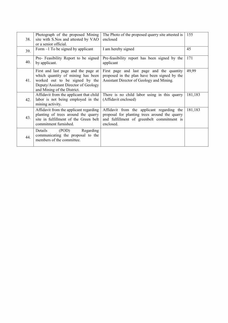
38.
Photograph of the proposed Mining
site with S.Nos and attested by VAO
or a senior official.
The Photo of the proposed quarry site attested is
enclosed
155
39. Form –1 To be signed by applicant I am hereby signed 45
40. Pre- Feasibility Report to be signed
by applicant.
Pre-feasibility report has been signed by the
applicant
171
41.
First and last page and the page at
which quantity of mining has been
worked out to be signed by the
Deputy/Assistant Director of Geology
and Mining of the District.
First page and last page and the quantity
proposed in the plan have been signed by the
Assistant Director of Geology and Mining.
49,99
42.
Affidavit from the applicant that child
labor is not being employed in the
mining activity.
There is no child labor using in this quarry
(Affidavit enclosed)
181,183
43.
Affidavit from the applicant regarding
planting of trees around the quarry
site in fulfillment of the Green belt
commitment furnished.
Affidavit from the applicant regarding the
proposal for planting trees around the quarry
and fulfillment of greenbelt commitment is
enclosed.
181,183
44.
Details (POD) Regarding
communicating the proposal to the
members of the committee.

1. Signature of the applicant
Executive Engineer
2. Recognized Qualified Person
G. Ravichandran, M.Sc., P.G.D., M.E.M.,
RQP/MAS/197/2005/A
ADDITIONAL REQUIREMENTS IN CASE OF SAND MINING
45 R.L. upstream Plate No. II 123
46 RL downstream Plate No. II 123
47 R.L. of starting point of mining site Plate No. II 123
48 R.L. of end point of mining site Plate No. II 123
49 Starting km., of the mining site of the
river Plate No. II 123
50 Ending km., of the mining site of the
river Plate No. II 123
51 Any shoals proposed? If yes details No 123
52 Total width of the river at 50m intervals
of the quarry length Plate No. II 123
53. Plan showing
a. Contour map at 25m intervals, from
50m of upstream and up to 50m of
downstream of quarry length
Plate No. II 123
b. Direction of flow Plate No. II 123
c. Bunds on either side of the river Plate No. II 123
d. Distance between bunds and the site on
either side of the river Plate No. II 123
e. S.F.No., Village name & Number,
habitation, temples, R.F, water bodies
any other structure located on either
side of the river bunds within 1km
radius
Plate No. II
123
f. Direction & location of the quarry site
with reference to the river width Plate No. II 123
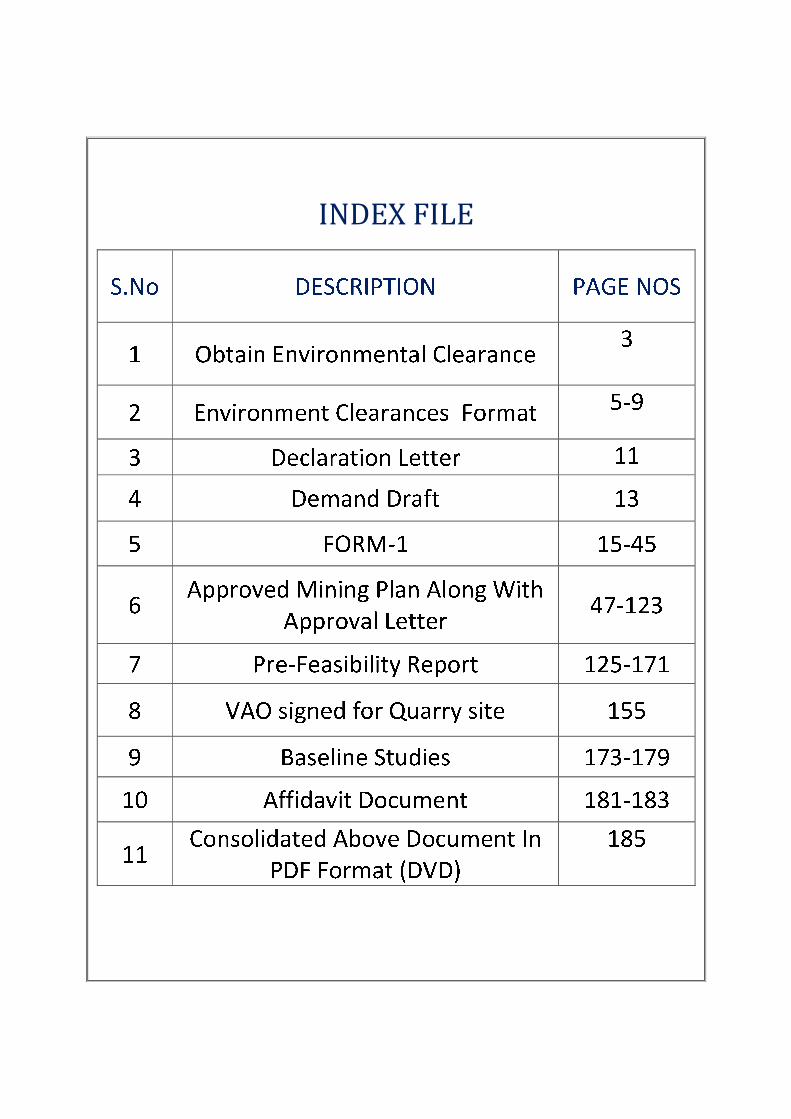
INDEX FILE

VALAVANUR SAND QUARRY LEASE APPLIED AREA (8.00.0HA)
The proponent Executive Engineer has applied for Environmental clearance for the proposed quarry
Valavanur Sand quarry for over an extent of 8.00.0Ha in S.F.No. 331 (P) at Valavanur Village, Arcot
Taluk, Vellore District and Tamilnadu.
Salient features of the proposal are as follows:
1. Name of the Owner + Firm : The Executive Engineer,
Public Works Department,
Water Resources Department,
Upper Palar Basin Division,
Vellore – 620001
Mobile No- 9943749888
Page No:
19,67,135,
2. Location of the quarry-
S.F.No.
: S.F.No. 331(P) at Valavanur Village, Arcot Taluk,
Vellore District
17,69,127,
135,
3. Purpose of Application : It is a Sand quarry project in Valavanur Village 17,67,135,
4. Extent of quarry in Ha- : 8.00.0Ha 17,69,135,
5. Land use planning
a) Mining
b) Storage of Topsoil over
burden
c) Infrastructure Road
d) Utilized Area
Total
:
It is a fresh lease area.
Nil
Nil
Nil
8.00.0Ha
8.00.0Ha
161
6. Production (quantity in m3) : The proposed quantity of sand is to be mined 80000m
3
(or) 13333 Lorry Loads of Sand up to a depth of 1m
below the river bed for a period of one Year.
Description Sand in m3
Geological Resources 240000
Mineable reserves 80000
One year plan period
As in the approved mining plan
80000
17,73,75,1
27,147,
7. Top soil & overburden
(quantity in m3)
: There is no overburden 79
8. Method of Mining : Opencast method of shallow mining is proposed,
Machineries like excavators are proposed for quarrying
this sand up to an average depth of 1m.
No drilling or blasting is proposed for this type of sand
quarrying, it is a conventional eco-friendly quarrying
operation.
75,129,145
,
9. Life of Mine as per approved
mining plan
: One Year only. 67,127
10. Height / width of the bench : 1m height and 200m width 77,
11. Source of water / quantity
required
Quantity
required
(in litres)
Source
27,149,165
a. Drinking &Domestic
Purpose
0.3 KLD Approved Water vendors
b. Dust Suppression 0.3KLD From nearby tank
c. Green belt development 0.4KLD From nearby tank

12. Waste water
Sewage water
Mode of disposal
:
:
There is no waste water. 31,165,
The septic tank is constructed on semi-permanent
structure within the quarry lease area.
To local Municipal Bodies.
13. APC Measures : 1.Mist Spray using water tankers,
2. Enclosed covered system. (Tarpaulin) for
transportation.
33,
14. Ariel distance of nearest
habitation
: S.No Name of the village Distance
Approximate
population
1. Vegamangalam 2.5km –S 400
2. Ariyur 2.5km –W 200 3. Valavanur 1.0km –NW 400
4. Thirparkadal 2.0km-NW 900
41,87,161,
15. Ariel distance from Reserve
forest, Sensitive areas, Forest,
Bird sanctuaries, Wild life
sanctuaries, National parks,
Monuments etc., within 15km
Moranam RF is situated 13km away from the South
eastern side of the area.
Wild life sanctuaries – Nil
Bird Sanctuary-Nil
National Park – Nil
Monuments – Nil
41,131,159
16. Land owner ship document
Own patta land
Lease
Govt. Poromboke
:
:
:
It is a Government poramboke land (Palar River)
maintained by Public Works Department, Water
Resources Department, Upper Palar Basin Division,
Vellore District.
69,113,
17. Land use classification : It is New Proposal Sand quarry project in Valavanur
village
69,97,161
18. Mining plan
Prepared by
:
G. Ravichandran, M.Sc.,P.G.D.,M.E.M.,
RQP/MAS/197/2005/A
67,117,
Approved by : The mining plan was got approved by the Deputy
Director, Vellore, vide Rc.No. 498/2015 (Mines)
Dated: 14.01.2016
47,
101 19. Precise area statement
Approved by
: The precise area communication letter was received
from The District Collector, Vellore vide Rc.No.
498/2015/Mines Dated: 04.01.2016
20. Nearby quarries : No quarries within the radius of 500m &1Km. 131,183
21. Nearby lake / river/ odai /
channel etc.
: The lease applied area lies in the Palar river. There is
stream/odai are present within 500m radius.
There are no other major water bodies like pond, lake
odai etc., within the radius of 500m.
Kaveripakkam lake is situated 6km away from the
North western side of the area.
81,
22. Latitude / Longitude : 12°52’04"N to 12°52’12"N
79°27’54"E to 79°28’08"E
69,119,139
23. GI Sheet No. : 57-P/05 69,119,139
24. Project Cost (Quarrying cost
+ EMP cost)
: The Project cost:
A. Cost of the Project =Rs. 14,77,000/-
B. EMP cost = Rs. 1,90,000/-
Total Project cost = Rs. 16,67,000/-
95,167,
25. EMP Cost (Capital and
recurring)
: EMP cost = Rs. 1,90,000/-
95,167,

26. Water table : The Ground water is about 6-7mt (Avg) depth below
ground level.
81,87
27. Interstate boundary (with
distance)
There is no interstate boundary within the radius of
15km
131,159,
28. Western Ghats (with distance) : The area does not falls Western Ghats within 15km
radius
131,159,


From:
The Executive Engineer,
Public Works Department,
Water Resource Department,
Upper Palar Basin Division,
Vellore – 620001
Mobile No- 9943749888
To:
THE CHAIRMAN,
STATE LEVEL ENVIRONMENT IMPACT ASSESSMENT AUTHORITY,
PANAGAL BUILDING, SAIDAPET,
CHENNAI
Sir,
Sub: Submission of Approved Mining Plan (Rc.No. 498/2015 (Mines) Dated:
14.01.2016) Form– 1and Pre-feasibility report for obtaining Environmental Clearance for
our Valavanur Sand Quarry Lease applied area- Reg
*****
I am here by submitting the processing fee in the form of demand draft for rupees twenty
thousand along with Form-1, Pre-feasibility report and Copy of Approved mining plan to your
good office for obtaining clearance from SEIAA, Chennai, for our Valavanur Sand Quarry Lease
applied area for over an extent of 8.00.0Ha situated in S.F.No: 331(P) at Valavanur Village,
Arcot Taluk, Vellore District, Tamilnadu.
I have submitted all the relevant documents to your good office to the best of our
knowledge. If any clarifications are required, we are ready to submit the same to your office at
your convenient time. Also we are ready to present the project in front of the committee.
Hence we request your good office to kindly process our application and allow us to
present our project at the earliest.
Thanking you.
Yours sincerely
Executive Engineer
Place: Vellore
Date: 20.01.2016


