Senior Thesis Geology and Mining History of Two Proposed ...
36
Senior Thesis Geology and Mining History of Two Proposed Reclamation Sites of the Wilds, Muskingum County, Ohio by Kathleen E. Gallaher 1995 Submitted as partial fulfillment of the requirements for the degree of Bachelor of Science in Geological Sciences at The Ohio State University, Winter Quarter, 1995 Approved by: ( 1 { • - I • I, • ( • • --------·--------------- f Dr. Garry D. McKenzie
Transcript of Senior Thesis Geology and Mining History of Two Proposed ...

Senior Thesis
Geology and Mining History of Two Proposed Reclamation Sites of the Wilds, Muskingum County, Ohio
by
Kathleen E. Gallaher
1995
Submitted as partial fulfillment of the requirements for the degree of Bachelor of Science in Geological Sciences at
The Ohio State University, Winter Quarter, 1995
Approved by:
( 1 ~ { ~~ • - I • I, • ( • •
--------·--------------- f
Dr. Garry D. McKenzie
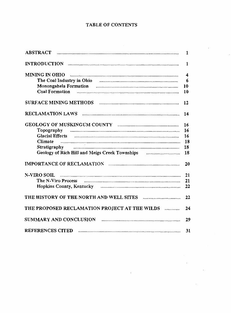
TABLE OF CONTENTS
ABSTRACT .................................................................................................. 1
INTRODUCTION 1
MINING IN OHIO 4 The Coal Industry in Ohio ............................................................... 6 Monongahela Formation .. . . . .. .. . . . . . . .... .. . . . . .......... ... . ............... ... . . ....... 10 Coal Formation .................................................................................. 10
SURFACE MINING METHODS ................................................................ 12
RECLAMATION LAWS .............................................................................. 14
GEOLOGY OF MUSKINGUM COUNTY ................................................. 16 Topography Glacial Effects Climate ............................................................................................... . Stratigraphy .................................................................................... . Geology of Rich Hill and Meigs Creek Townships .......................... .
16 16 18 18 18
IMPORTANCE OF RECLAMATION ......................................................... 20
N-VIRO SOIL ................................................................................................. 21 The N-Viro Process ............................................................................. 21 Hopkins County, Kentucky ................................................................ 22
THE HISTORY OF THE NORTH AND WELL SITES .............................. 22
THE PROPOSED RECLAMATION PROJECT AT THE WILDS ............ 24
SUMMARY AND CONCLUSION ............................................................... 29
REFERENCES CITED ................ ....... ............. ................................... ........... 31
LIST OF FIGURES
Figure 1: The location of the Wilds 2
Figure 2: Oil and gas field map of Ohio .................................................................... 5
Figure 3: Coal production in Ohio from 1875 to 1993 7
Figure 4: Tonnage of coal produced by county and method in Ohio during 1993 .......................................................... 8
Figure 5: Location of the Ohio coal fields in the eastern and southern portions of the state
Figure 6: The Bituminous Coal Basin in the United States, extending from Ohio to Alabama
9
11
Figure 7: Diagram of area strip-mining ..................................................................... 13
Figure 8: Diagram of contour mining ........... ............................................................. 15
Figure 9: Location of Muskingum County in Ohio
Figure 10: The general stratigraphic section of Muskingum County
Figure 11: The Well Site displays sparse vegetation
Figure 12: The North Site, located in Meigs Township
17
19
23
25
Figure 13: The gently rolling topography of the Wilds ............................ .................... 26
Figure 14: The Well Site displaying the eight Sm x lOm plots 27
Figure 15: The North Site plots .................................................................................. 28
Figure 16: Lori Goins(right) and Billie Harrison collect a soil sample from the North Site .................................................... 30
ACKNOWLEDGMENTS
I wish to express thanks and appreciation to Dr. Garry McKenzie for all his helpful
suggestions, careful guidance, and constructive advice. Special thanks needs to be given
to Dr. Terry Logan and his research assistants, Billie Harrison and Lori Goins. Their help
was appreciated in the organization and preparation of the research site.
Thanks also to Dr. Evan Blumer, the director of Science and Animal Health at the
Wilds. I am also grateful to David Buchanan and Allen Kraps of the U.S. Department of
Interior, Bureau of Surface Mining, Tom Hines of the Ohio Division of Reclamation, and
Tom Willman of the Zanesville reclamation office. Their time and cooperation were
greatly appreciated. I am also appreciative to Ruth Ohlinger of the American Electric
Power Company for the information she provided.
Finally, a personal acknowledgment to my parents for their love and encouragement.

ABSTRACT
Abandoned strip-mined lands in Ohio are being reclaimed under state and federal
regulations. The abandoned lands are required to be returned to the same or better
condition than before mining. Many reclaimed areas, including the Wilds, are being
returned to productive uses that consist of recreation areas, wildlife areas, golf courses,
and pastures. Two sites at the Wilds in Muskingum County, Ohio were chosen for this
study. Neither site was suitably reclaimed using lime fertilizer. The proposed reclamation
project at the Wilds is to examine the effectiveness of N-Viro Soil, a bio-organic aglime
topsoil, on the two sites. The N-Viro Soil is expected to adjust the pH of the soil,
increase nutrients, and add organics. Although the project was designed for continuing
research, the information gathered from previous projects suggests that predictions can be
made about the effectiveness of the N-Viro Soil on the current two sites.
INTRODUCTION
The problem of environmental degradation caused by surface mining is widespread
and serious. Surface mining drastically alters the ecological characteristics of the area
disturbed and can have an effect on surrounding areas. Vegetation is removed,
topographic features and characteristics are changed, and the original geological surfaces
and soils destroyed. This has. resulted in areas of unsightly landscapes and soils that are
essentially useless. This paper was designed to investigate the effect of N-Viro Soil in
reclamation of surface mine spoils.
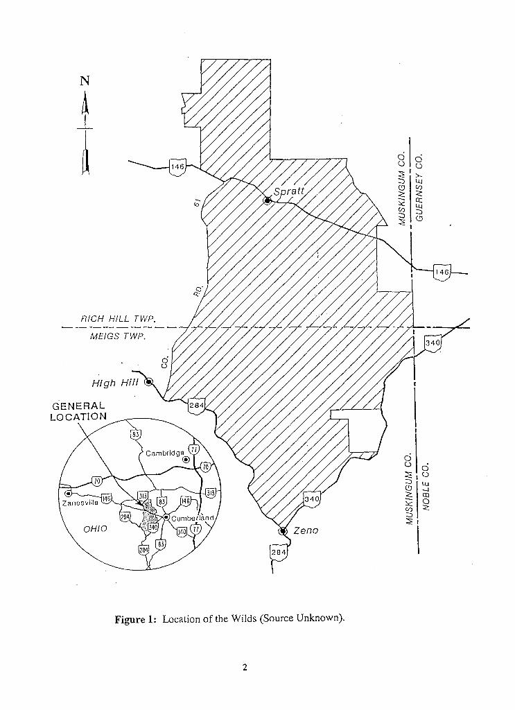
The study area is in a 9,154-acre wild-animal preserve, the Wilds, located in
Muskingum County, Ohio. The Wilds, originally known as the International Center for
the Preservation of Wild Animals, is located 15 miles southeast of Zanesville, Ohio (Figure
1 ). It is 14 miles to the west of the village of Cumberland and 15 miles southwest of
1
N
RICH HILL TWP.
MEIGS TWP.
OHIO
Figure 1: Location of the Wilds (Source Unknown).
2

Cambridge. The preserve's goal is as a breeding center for rare and endangered species of
animals as well as a wild animal research center and educational facility (Artzner, 1994).
Some of the wildlife species include the southern white rhinoceros, Przewalski's wild
horse, North American red wolf, Bactrian camels, Scimitar-homed oryx, Cuvier's gazelle,
and Trumpeter swans. The preserve opened to the public in 1994.
The preserve's land was originally surface mined for coal and limestone. On July
30, 1986, this land was donated to the Wilds by the American Electric Power and Ohio
Power Company (Brennan, 1986). Most of the land had been reclaimed under Ohio's
strict reclamation laws. These laws, which took effect in 1972, required that the land be
returned to the same or better condition than before mining (BUSML, 1974). The
reclamation included r.esloping the land, laying down of topsoil, and the reseeding of
grasses and trees. Today, the Wild's landscape includes lakes, woodlands, wetlands, and
grasslands.
Although the title to the land was passed to the Wilds in 1986, the mineral rights
remained with oil companies, coal companies, and earlier landowners. Parts of the land
now occupied by the Wilds have been sites for oil and gas wells. Many of the wells,
drilled from the Conemaugh Group, are still producing.
The two sites chosen for this study had not been returned to suitable condition
after reclamation efforts. The Well Site was reclaimed under the 1972 reclamation laws
and may have been impacted by the activity of the nearby well. As a result of destructive
spoils and soils at the well sites and waste produced by hydrocarbons, well sites are
commonly sparsely vegetated.
The North Site was reclaimed under the 1977 reclamation laws and may have been
impacted by vehicle traffic from the numerous nearby roads. The use of the N-Viro Soil is
expected to adjust the pH of the soil, increase nutrients, and add organics. If the N-Viro
soil demonstrates a positive effect, it could be useful in future strip mine reclamation
efforts.
3
MINING IN OHIO
Ohio has a long history of mineral and natural resource production. Many of
Ohio's counties depend on mineral extractions as their dominate industries. One of the
earliest mined minerals was flint. The most abundant occurrence of flint is located at Flint
Ridge which extends from Licking County, south to Muskingum County. Flint's earliest
use was by Ohio Indians and later by settlers. A variety of objects including knives,
arrowheads, and spearheads has been traced to a Flint Ridge source (Collins, 1987).
Another mineral resource used by early settlers was salt. The salt was obtained
from natural brines produced from wells located in the Mississippian and Pennsylvanian
aged sandstones (Collins, 1987). Meigs County was the most successful salt industry,
though the industry was also developed in Columbiana, Guernsey, Hocking, Morgan, and
Tuscarawas Counties. Rock salt was later discovered in northeastern Ohio, particularly
Cuyahoga, Lake, Medina, Summit, and Wayne Counties.
It was not until the 1860's that heavy exploration of gas and oil was undertaken in
Ohio, though the presence of oil in Ohio had been known even by the earliest settlers. The
Indians and European settlers found small amounts of petroleum on the surface of streams
and used it for medicinal purposes (Collins, 1987).
The first serious efforts for commercial gas and petroleum development occurred
mainly in the northwestern portion of Ohio. The Lima-Indiana field was the first "giant"
field in the United States, reaching a net production peak of 24 million barrels in 1896
(Collins, 1987). The industry was later developed in the eastern section of the state. Gas
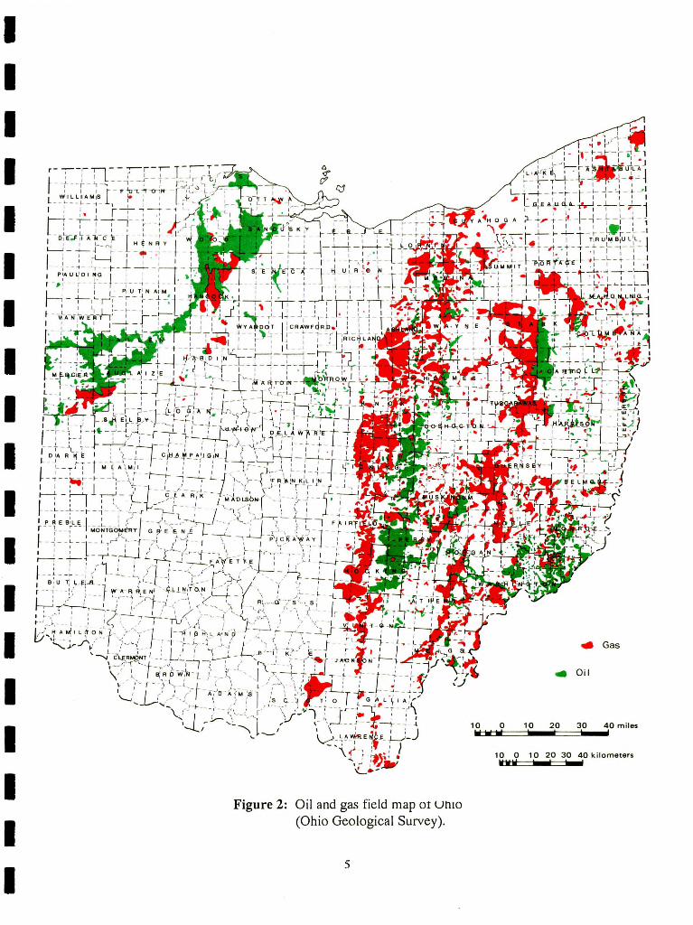
and oil fields extend from Cuyahoga County in the north to Lawrence County in the south
(Figure 2).
The Division of Oil and Gas estimates that 822 new wells were drilled in Ohio in
1993 (Weisgarber, 1994). The top five counties were Muskingum, Coshocton, Holmes,
4
I I I I I I I I I I I I I I I I I I I
Figure 2: Oil and gas field map or un1o (Ohio Geological Survey).
5
Gas
• Oil
1~0t::ii:iito==j1 lii0--2t0~~3i0~_;;40 miles
10 0 10 20 30 40kilometers !1!1111!11 beeezl lwwl
Portage, and Stark. In Muskingum County, 61 new wells were drilled with 45 wells
productive. The oil and gas industry is still a major contributor to the state's mineral
economy, though production decreased by 6.2% in 1993 (Weisgarber, 1994).
Small amounts of gypsum are also mined in Ohio. A substantial industry is located
in Ottawa County, along the shoreline of Lake Erie. Gypsum is currently used in the
manufacturing of plaster, wallboard, and cement (Collins, 1987).
Large quantities of limestone and dolostone are quarried throughout Ohio.
Limestone and dolostone are used to produce aglime, cement, glass, and aggregates.
Substantial amounts of building stone, especially Berea sandstone, are also mined. Other
industrial rocks and minerals include clays, shale, sand, and gravel. These materials have a
large variety of uses including tile, pottery, grindstones, pipes, and cement. In 1993, Ohio
reported a net production of 47,972,399 tons of sand and gravel (Weisgarber, 1994). This
ranks Ohio second nationally in the production of sand and gravel. The majority of sand
and gravel is found in fluvial and glacial material in northeastern Ohio (Collins, 1987).
The Coal Industry in Ohio
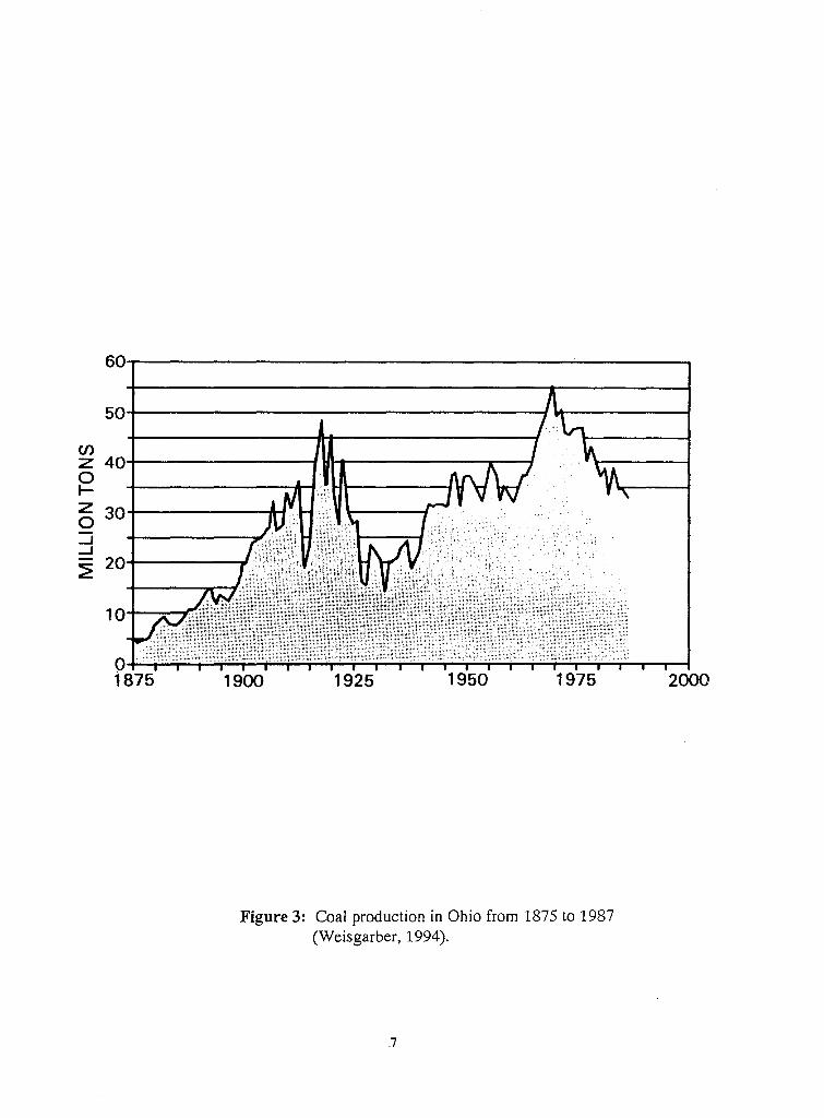
Coal is Ohio's most valuable mineral resource and has been mined in significant
amounts since the late 1800's. Figure 3 shows a graph of coal production in Ohio, dating
from 1875 to 1987. The coal industry in Ohio during 1993 produced 27,668,810 tons of
coal (Weisgarber, 1994). Figure 4 shows the tonnage of coal produced by county and the
methods used during 1993.
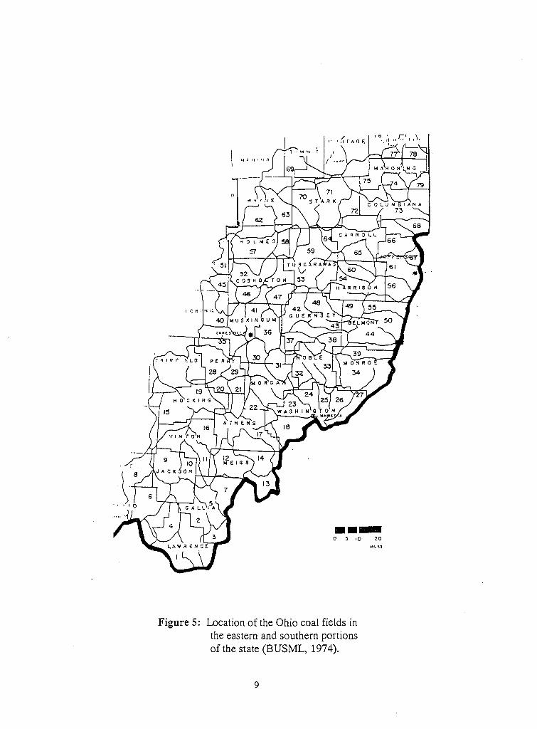
Ohio coal resources are located in 30 counties in the eastern and southern portion
of the state (Figure 5). These resources lie on the northwestern edge of a structure known
as the main bituminous coal basin (BUSML, 1974). The basin extends from north-central
Pennsylvania through eastern Ohio, West Virginia, western Maryland, and down into
6
en Z 40-t-~~~~~~~_...H_...._~~~~~~----1 0 t-
~ 30 ::i _J
::? 20
o..J-;.;.~~~~~~~~~~:::=.;:~~~~..;,;.:.:.;.~~~----~ 1875 1900 1925 1950 1975
Figure 3: Coal production in Ohio from 1875 to 1987 (Weisgarber, 1994).
7
2000

Total Underground Surface
All methods number Number of Production <short tons) Number of Production I short tonsl County' <short tons) of underground surface
mines mines Total Longwall Conventional Continuous mines Total Strip reporting underground miner reporting surface
Belmont 5,904,179 21' 1 3,968,101 3,075,487 892,614 202 1,936,078 1.771,049 Carroll 107,572 7 7 107.572 107,532 Columbiana 1,131,047 14 3 490,772 490,772 11 640,275 595.962 Coshocton 1,347,597 14 14 1,347,597 1.263.065 Guernsey 402,250 8 8 402,250 364,205
Harrison 2,447,095 13 1 1,175,173 1,175,173 12 1,271,922 1.170,770 Holmes 153,635 5 5 153,635 153.635 ,Jackson 1.250,717 92 92 1,250.717 1,250,717 Jefferson 1,673,447 22 1 261,792 261,792 21 1,411.655 1.250.576 Lawrence 9,611 1 1 9,611 9.611
Mahoning 4,837 2 2 4,837 4,837 Meigs 2,895,853 2 2 2,895,853 2,453,309 442,544 Monroe 827,377 1 1 827,377 765,987 61,390 Morgan 46,549 p l3 46.549 46,549 Muskingum 2,350,330 32 32 2,350,330 2,240,141
Noble 1,065,855 8 8 1,065,855 1.054.230 Perry 395,321 7 7 395,321 325,116 Stark 230,340 6 6 230,340 230,340 Tuscarawas 2,388,339 39 39 2.388,339 2.144.064 Vinton 2,950,455 92 1• 853,258 683,015 170,243 92 2,097,197 2,097,197 Wayne 3,169 1 1 3,169 3,169
TOTAL 27,585,575 192 9 10,472,326 6,977,798 0 3,494,528 183 17,113,249 16.082,765
!Production from mines operating in more than one county was evenly split between the counties involved unless a by-county breakdown was provided hy the opt'rntor. :zooee not include mines extending into this county from adjoining counties. Yfhis mine extends into Morgan County from Noble County and is not included in the total number of mines. 4This mine extends into Vinton County from Meigs County and is not included in the total number of mines.
Figure 4: Tonnage of coal produced by county and method during 1993 (Weisgarber, 1994).
8
Auger
165.029 40
44.313 84,532 311.045
101,152
161,079
110,189
11,625 70,205
244,275
1,030,484
/ 1· • 1 II TA 0 F.:
I)
··-0 ~ 10 20
Figure 5: Location of the Ohio coal fields in the eastern and southern portions of the state (BUSML, 1974).
9
WILf:S
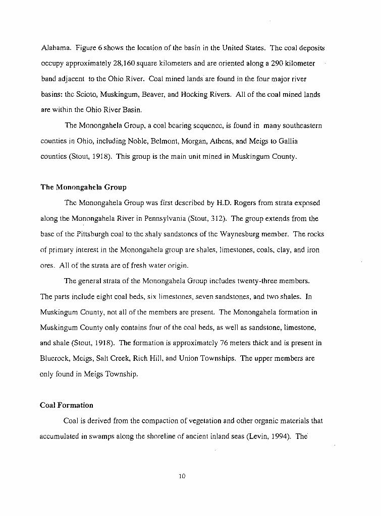
Alabama. Figure 6 shows the location of the basin in the United States. The coal deposits
occupy approximately 28,160 square kilometers and are oriented along a 290 kilometer
band adjacent to the Ohio River. Coal mined lands are found in the four major river
basins: the Scioto, Muskingum, Beaver, and Hocking Rivers. All of the coal mined lands
are within the Ohio River Basin.
The Monongahela Group, a coal bearing sequence, is found in many southeastern
counties in Ohio, including Noble, Belmont, Morgan, Athens, and Meigs to Gallia
counties (Stout, 1918). This group is the main unit mined in Muskingum County.
The Monongahela Group
The Monongahela Group was first described by H.D. Rogers from strata exposed
along the Monongahela River in Pennsylvania (Stout, 312). The group extends from the
base of the Pittsburgh coal to the shaly sandstones of the Waynesburg member. The rocks
of primary interest in the Monongahela group are shales, limestones, coals, clay, and iron
ores. All of the strata are of fresh water origin.
The general strata of the Monongahela Group includes twenty-three members.
The parts include eight coal beds, six limestones, seven sandstones, and two shales. In
Muskingum County, not all of the members are present. The Monongahela formation in
Muskingum County only contains four of the coal beds, as well as sandstone, limestone,
and shale (Stout, 1918). The formation is approximately 76 meters thick and is present in
Bluerock, Meigs, Salt Creek, Rich Hill, and Union Townships. The upper members are
only found in Meigs Township.
Coal Formation
Coal is derived from the compaction of vegetation and other organic materials that
accumulated in swamps along the shoreline of ancient inland seas (Levin, 1994). The
10
repetitive formation of the coal layers and the rocks between them was the result of
geologic and environmental conditions when the ancient sea existed. The sequence of
events involved were the initial formation of the swamp, a general lowering of the land
surface due to flooding of the swamp, the accumulation of sediments on top of the flooded
swamp, followed by the establishment of a new swamp on the accumulated sediments.
These general conditions also produced variations in thickness, geographic extent, quality,
and chemical nature of the coal layers.
SURFACE MINING METHODS
The choice of mining methods depends on the geology and topography of the mine
site. Various methods include contour, area, and auger mining. The major methods of
surface mining are combinations of these three types of mining.
Area mining is performed in relatively flat to gently rolling terrain. Contour mining
is conducted where deposits are found in hilly or mountainous areas. Augering, which is
drilling horizontally into a coal seam, is usually used with contour mining to increase the
coal recovery (CSR, 1981).
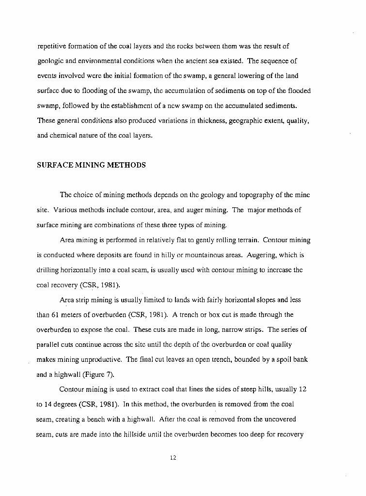
Area strip mining is usually limited to lands with fairly horizontal slopes and less
than 61 meters of overburden (CSR, 1981 ). A trench or box cut is made through the
overburden to expose the coal. These cuts are made in Jong, narrow strips. The series of
parallel cuts continue across the site until the depth of the overburden or coal quality
makes mining unproductive. The final cut leaves an open trench, bounded by a spoil bank
and a highwall (Figure 7).
Contour mining is used to extract coal that lines the sides of steep hills, usually 12
to 14 degrees (CSR, 1981). In this method, the overburden is removed from the coal
seam, creating a bench with a highwall. After the coal is removed from the uncovered
seam, cuts are made into the hillside until the overburden becomes too deep for recovery
12
Figure 7: Diagram of area strip-mining (CSR, 1981).
13
- .... - ....... .:: -~-..:::- .L...,.._, . . .... ' ·-- . -..A- - 411..., .,_ --:--_-
- • - f .. _-,,. .. • ..,...,. I
~-. ..~. _,.
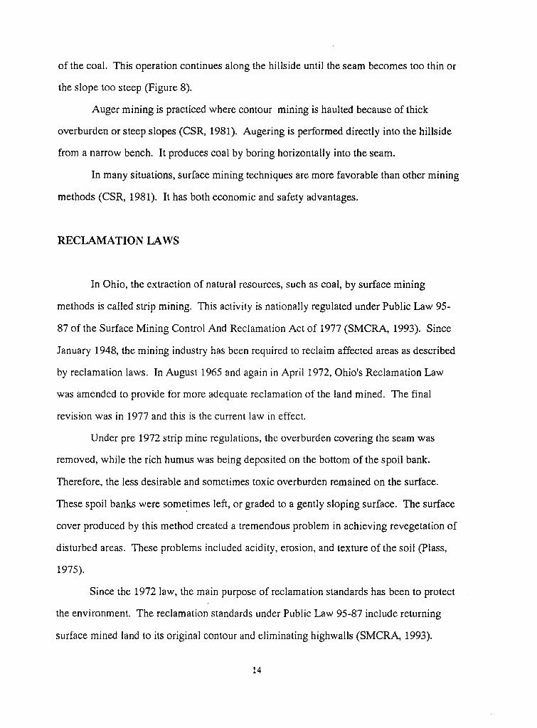
of the coal. This operation continues along the hillside until the seam becomes too thin or
the slope too steep (Figure 8).
Auger mining is practiced where contour mining is haulted because of thick
overburden or steep slopes (CSR, 1981). Augering is performed directly into the hillside
from a narrow bench. It produces coal by boring horizontally into the seam.
In many situations, surface mining techniques are more favorable than other mining
methods (CSR, 1981). It has both economic and safety advantages.
RECLAMATION LAWS
In Ohio, the extraction of natural resources, such as coal, by surface mining
methods is called strip mining. This activity is nationally regulated under Public Law 95-
87 of the Surface Mining Control And Reclamation Act of 1977 (SMCRA, 1993). Since
January 1948, the mining industry has been required to reclaim affected areas as described
by reclamation laws. In August 1965 and again in April 1972, Ohio's Reclamation Law
was amended to provide for more adequate reclamation of the land mined. The final
revision was in 1977 and this is the current law in effect.
Under pre 1972 strip mine regulations, the overburden covering the seam was
removed, while the rich humus was being deposited on the bottom of the spoil bank.
Therefore, the less desirable and sometimes toxic overburden remained on the surface.
These spoil banks were some_times left, or graded to a gently sloping surface. The surface
cover produced by this method created a tremendous problem in achieving revegetation of
disturbed areas. These problems included acidity, erosion, and texture of the soil (Plass,
1975).
Since the 1972 law, the main purpose of reclamation standards has been to protect
the environment. The reclamation standards under Public Law 95-87 include returning
surface mined land to its original contour and eliminating highwalls (SMCRA, 1993).
14
1. SITE PREPARATION 2. DRILLING & BLASTING OVERBURDEN 3. REMOVAL OF OVERBURDEN 4. EXCAVATING & LOADING COAL
Figure 9: Diagram of contour mining (CSR, 1981).
15
Affected areas must be resoiled with at least six inches of topsoil or suitable subsoil and all
toxic materials covered. The addition of lime or fertilizer is required in order to achieve
diverse vegetation such as grasses and legumes. All grasses and legumes must be capable
of self-regeneration. Grading and recontouring the affected land must be accomplished
within one year following the mining. The entire reclamation process must be completed
in three years following the mining of the land (Kraps, 1995).
GEOLOGY OF MUSKINGUM COUNTY
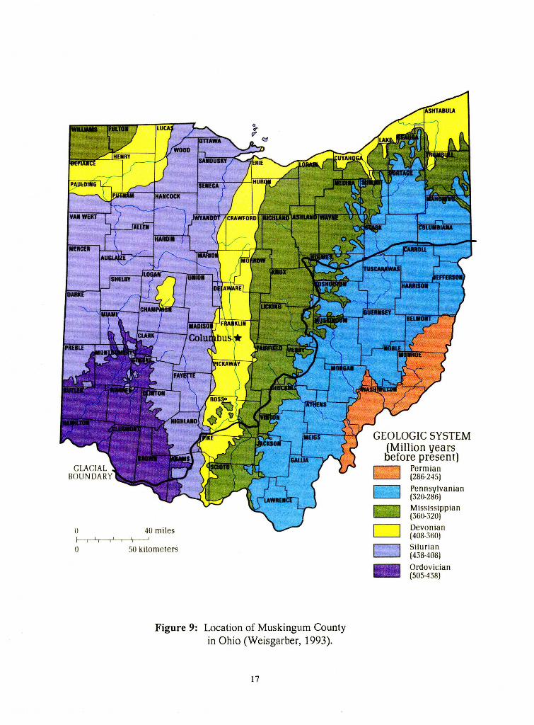
Muskingum County is located in the east-central part of the state and is bounded
on the north by Coshocton County and the south by Morgan and Perry Counties (Stout,
1918). Guernsey and Noble Counties are on the east, while Perry and Licking Counties
are found bordering on the west (Figure 9). The county lies in the central part of the
Muskingum River Basin. The total area of the county is 416,640-acres (Steiger, 1991).
Topography
Muskingum County is part of the unglaciated Allegheny Plateau of the
Appalachian Plateau Province (Stout, 1918). The northern, western, and central sections
of the county are hilly with wide ridges and gentle slopes and valleys.
The eastern portion of the county is described with steep and rugged hills, caused
by crustal uplift, erosion, weathering, and deposition (Stout, 1918). The ridges and
valleys are narrow and commonly have steep side slopes.
Glacial Effects
The last glacial period, the Wisconsinan, did not enter Muskingum County,
though it did affect the area (Stout, 1918). The melting ice sheets caused erosion. Much
of the
16
()
0
40 miles
50 kilometers
Figure 9: Location of Muskingum County in Ohio (Weisgarber, 1993).
17
GEOLOGIC SYSTEM (Million years before present)
CJ Permian (286-245)
CJ Pe nn sylvanian (320-286)
~ M ississippian (360-320)
D Devonian (408-360)
D Silurian (438-408) - Ordovician (505-438)
sediment in the river valleys was a direct result from the outwash during the Wisconsinan
glaciation.
Climate
Ohio is in the north temperate climate zone. The climate is classified as humid
with warm summers and mildly cold winters (Sanderson, 1950). Temperatures average
from 49.7°F in northern counties to S6.6°F in the southern counties. Maximum
temperatures range from 103° F to 107°F and minimum temperatures range from -33°F to
-17' F. The annual precipitation is 48 inches. The average length of the growing season
varies from 146 to 163 days. The first and last frosts occur in October and May
respectively.
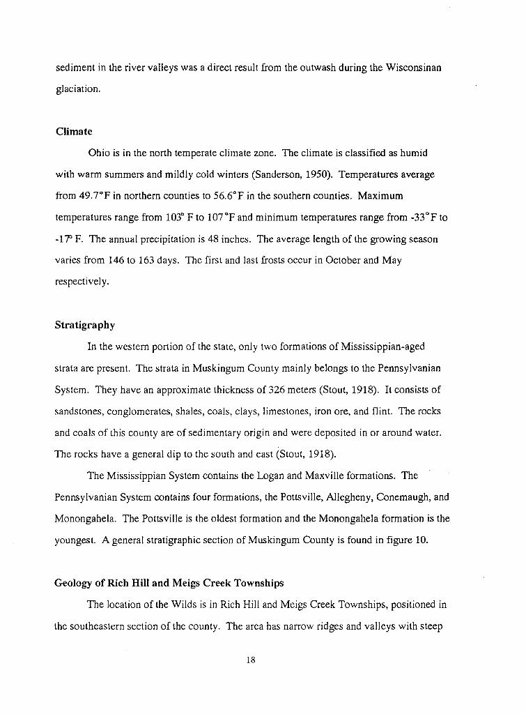
Stratigraphy
In the western portion of the state, only two formations of Mississippian-aged
strata are present. The strata in Muskingum County mainly belongs to the Pennsylvanian
System. They have an approximate thickness of 326 meters (Stout, 1918). It consists of
sandstones, conglomerates, shales, coals, clays, limestones, iron ore, and flint. The rocks
and coals of this county are of sedimentary origin and were deposited in or around water.
The rocks have a general dip to the south and east (Stout, 1918).
The Mississippian System contains the Logan and Maxville formations. The
Pennsylvanian System contains four formations, the Pottsville, Allegheny, Conemaugh, and
Monongahela. The Pottsville is the oldest formation and the Monongahela formation is the
youngest. A general stratigraphic section of Muskingum County is found in figure 10.
Geology of Rich Hill and Meigs Creek Townships
The location of the Wilds is in Rich Hill and Meigs Creek Townships, positioned in
the southeastern section of the county. The area has narrow ridges and valleys with steep
18
w :2 F 0
§ 0 w (!)
28
32
STRATIGRAPHI en UNITS
ROCK UNITS en w 2 ::::? a..
FORMATION MEMBERS OR BEDS 0 w g I t5 I- >-Cf) MUSKINGUM COUNTY
:'.S WAYNESBURG COAL UJ MEIGS CREEK COAL
E :r: UNIONTOWN COAL <I'. FISHPOT LIMESTONE c.o Cl BENWOOD LIMESTONE POMEROY COAL f".. 0
SEWICKLEY SANDSTONE PITTSBURGH COAL z 0 :::E
z I <( (!) AMES LIMESTONE
BUFFALO SANDSTONE E z :::> SALTSBURG SANDSTONE
BRUSH CREEK LIMESTONE ~ COW RUN SANDSTONE
""'" :;; . PORTERSVILLE SHALE MAHONING COAL CJ) w MAHONING SANDSTONE z CAMBRIDGE LIMESTONE __J 0 >- 0
CJ)
z >-z z UPPER FREEPORT COAL COLUMBIANA SHALE E w w UPPER FREEPORT SANDSTONE LOWER KITTANNING COAL I
N CL (!) LOWER FREEPORT COAL VANPORT LIMESTONE l!) w WASHINGTON SHALE CLARION COAL
.....I MIDDLE KITTANNING COAL PUTNAM HILL LIMESTONE .....I
<(
UJ HOMEWOOD SANDSTONE LOWELLVILLE LIMESTONE -' E -' UPPER MERCER LIMESTONE MASSILLON SANDSTONE 5 LOWER MERCER LIMESTONE QUAKERTOWN COAL c.o (/)
""'" I- LOWER MERCER COAL SHARON COAL I- BOGGS LIMESTONE SHARON SANDSTONE 0 c..
z <(
z 5 E <( w co :2
<( CL a: CL ~w CJ)
w:2 (!) 0
CJ) <(Z en<(
E CJ) oz CJ)
<(
0 a: ""'" ~
w I-en w I I CUYAHOGA FORMATION 0 /
Figure 10: The general stratigraphic section of the Monongahela Group in Muskingum County,
Ohio (Hull, 1990).
19
slopes. The strata consists of sandstone, conglomerates, shales, clay, coal ,and limestone
(Stout, 1918).
The soils of Rich Hill and Meigs Creek Townships are generally of two
associations, the Lowell-Guernsey-Gilpin and the Morristown-Fairpoint-Bethesda
(Steiger, 1991). The major soils in the Lowell-Guernsey-Gilpin Association are formed in
colluvium from the underlying bedrock of clay, shale, limestone, and siltstone (Steiger,
1991). These soils occupy ridges and hillsides that are strongly sloping to very steep. The
soil ranges from moderately well drained to well drained.
The Morristown-Fairpoint-Bethesda Association are soils located in and around
areas that have been surface mined (Steiger, 1991). These soils occupy a sloping to very
steep topography and are composed of clay, shale, and limestone fragments. These soils
are considered to be well drained.
THE IMPORTANCE OF RECLAMATION
Surface mine reclamation has many positive benefits. It can improve the
topography of the land, fertility of the soil, and the economic value of the original mine
site and surrounding areas (Plass, 1975). Ultimately, reclaimed mine sites are returned to
many productive uses including recreation areas, golf courses, wildlife areas, parks, farms,
wetlands, housing developments, and pastures. Without reclamation efforts, threats to the
environment would be present. These threats are acid-mine drainage and erosion and
sedimentation (McKenzie, 1979). Because of these threats, adequate control of water
drainage from the mine site is an important aspect of the reclamation process.
Spoil banks, a heterogeneous mixture of sandstone, limestone, shale, and soil,
begin to weather and erode as soon as mining operations begin. Spoil material weathers
and erodes rapidly, carrying particles into streams. How severe the erosion is depends on
the steepness of the slope and the amount of precipitation (Plass, 1975). Landslides, haul
20

roads, and poor road design also contribute to erosion problems (McKenzie and Studlick,
1979).
Soil erosion and sedimentation cannot be totally eliminated but covering the soil
with vegetation can control the erosion (Plass, 1975). Revegetation includes soil
preparation, seeding and planting, and irrigation. The type of revegetation used is
determined by the acidity of the soil, fertility of the soil, slope of the affected area, and the
proposed future use of the site.
N-VIRO SOIL
N-Viro Soil is a granular, soil-like material that results when cake sewage sludge is
mixed with cement or lime kiln dust or another type of alkaline admixture (Burnham et al.,
1990). N-Viro Soil makes an excelle.nt material for use in reclamation of surface mine
spoils due to its physical and chemical properties.
N-Viro Soil has been used in over 30 areas worldwide, including Australia,
England, and the United States (N-Viro International Corporation). N-Viro Soil was
honored in 1990 by the United States Environmental Protection Agency with the first
place award for Sludge Utilization Technology Development. It also received a
Presidential Citation for excellence in Innovative Development of Technology for the
nation's Environmental Challenge Award's Program.
The benefits of N-Viro Soil include its ability to adjust pH, immobilize metals,
increase nutrients, and add organics. The product has been useful to farmers, land
reclamation contractors, and land fill operators.
The N-Viro Process
The N-Viro process begins with the mixing of dewatered sludge and alkaline
admixtures (N-Viro International Corporation). The blended mixture is then exposed to
21
accelerated mechanical drying and chemical heat pulses, a twelve hour process. The
chemical heat pulse, between the sludge and alkaline admixture, raises the temperature to
52 degrees Celsius and the pH level to 12 of the blend. After a 3-7 day drying period, the
N-Viro Soil is ready for use. Because of N-Viro Soil's stability, it can be safely stored for
extended periods of time.
Hopkins County, Kentucky
N-Viro Soil has proven effective in many applications including reclamation of an
acid mine spoil in Hopkins County, Kentucky. In October 1988, 100 tons per acre of
N-Viro Soil was applied to the project site (Logan et al., 1994). The area was seeded
with a mixture of orchard grass, white sweet clover, blue grass, and sericea lespedesa. In
the spring of 1990, the project area contained thick grasses and showed evidence of
wildlife habitance. The pH of the soil was increased to the range of 6.0 to 7.3. This was
quite an effective increase from its previous pH of 2.5.
HISTORY OF THE NORTH AND WELL SITE
Two sites in the Wilds were chosen for this study, one known as the Well Site and
the other the North Site. Each site was reclaimed under different reclamation laws.
The Well Site is located in Rich Hill Township. This portion of the Wilds was
mined by Central Ohio Coal Company using the area strip-mining method. When the
mining of the Meigs Creek No.9 Coal ceased, the acreage mined was reclaimed under the
1972 reclamation laws. Reclamation included filling, grading, resoiling, and planting trees.
As the name implies, the Well Site is located near a gas well which may have
influenced the reclamation efforts. As a result of destructive spoils and soils and waste
produced by hydrocarbons, this site is sparsely vegetated (Figure 11).
22
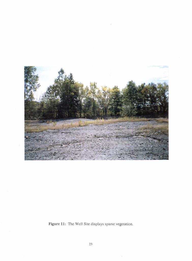
Figure 11 : The Well Site displays sparse vegetation.
23
The North Site, located in Meigs Township, was also mined by Central Ohio Coal
Company. The unit mined was the Meigs Creek No.9 Coal, extracted using the area strip
mining method. When the mining activity ended, the area was reclaimed under the newest
reclamation Jaw. The Reclamation Act of 1977 insured the elimination of highwalls. Most
of the acreage has been reclaimed in grasslands. The North Site reclamation may have
been impacted by the traffic of nearby roads (Figure 12).
Both sites were mined by a machine nicknamed Big Muskie. Big Muskie is the
largest strip-mining machine ever built (Mclnnis, 1989). Its cab and machinery enclosure
is 140 feet Jong, 120 feet wide, and 40 feet high. It can scoop up 325 ton bites and
relocate its load a few hundred feet away. When the mining is finished, Big Muskie
returns the fill and topsoil. Big Muskie is no longer in service, but remains on display in
Muskingum County.
THE PROPOSED RECLAMATION PROJECT AT THE WILDS
The proposed reclamation project at the Wilds is to examine the effectiveness of
N-Viro Soil on acid-mine spoils. Two sites were chosen for the project.
The characteristic topography of the area surrounding the sites displays gently
rolling hills and valleys (Figure 13). The two sites chosen are areas that had been strip
mined and not reclaimed successfully using lime fertilizer.
The two sites are the Well Site and the North Site. In October 1994, each site was
divided into eight plots, into which the soil will be laid.
At the Well Site each Sm x lOm plot was marked off using small flags (Figure 14).
A sample of soil was collected from each plot to be analyzed. The pH of the soil was 3.05
and contained a large amount of shaly fragments.
At the North Site, each 4m x Sm plot was also marked by small flags (Figure 15).
24

Figure 12: The North Site, located in Meigs Township.
25
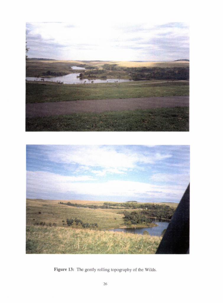
Figure 13: The gently rolling topography of the Wilds.
26
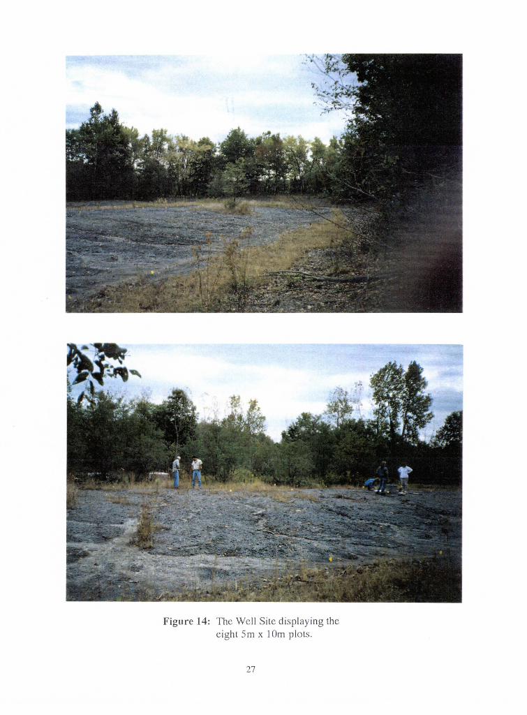
Figure 14: The Well Site displaying the eight Sm x 1 Om plots.
27

Figure 15: T he North Site plots.
28
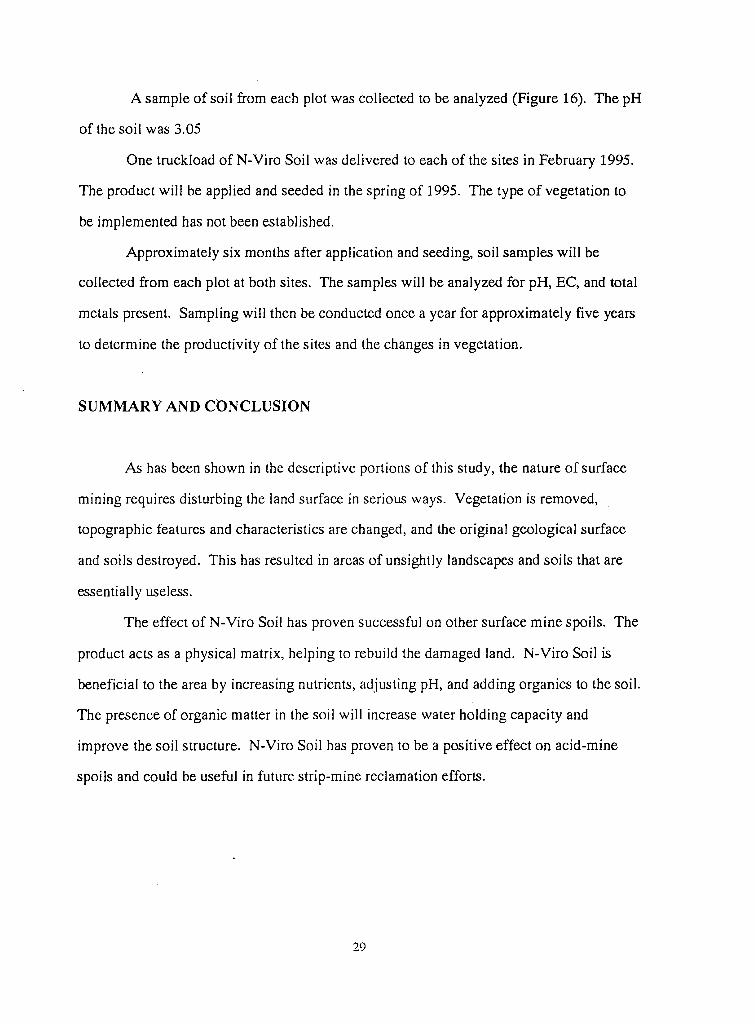
A sample of soil from each plot was collected to be analyzed (Figure 16). The pH
of the soil was 3.05
One truckload of N-Viro Soil was delivered to each of the sites in February 1995.
The product will be applied and seeded in the spring of 1995. The type of vegetation to
be implemented has not been established.
Approximately six months after application and seeding, soil samples will be
collected from each plot at both sites. The samples will be analyzed for pH, EC, and total
metals present. Sampling will then be conducted once a year for approximately five years
to determine the productivity of the sites and the changes in vegetation.
SUMMARY AND CONCLUSION
As has been shown in the descriptive portions of this study, the nature of surface
mining requires disturbing the land surface in serious ways. Vegetation is removed,
topographic features and characteristics are changed, and the original geological surface
and soils destroyed. This has resulted in areas of unsightly landscapes and soils that are
essentially useless.
The effect of N-Viro Soil has proven successful on other surface mine spoils. The
product acts as a physical matrix, helping to rebuild the damaged land. N-Viro Soil is
beneficial to the area by increasing nutrients, adjusting pH, and adding organics to the soil.
The presence of organic matter in the soil will increase water holding capacity and
improve the soil structure. N-Viro Soil has proven to be a positive effect on acid-mine
spoils and could be useful in future strip-mine reclamation efforts.
29
Figure 16: Lori Goins(right) and Billie Harrison collect a soil sample from the North Site.
30
REFERENCES CITED
Artzner, M. W., 1994. Vision, Progress, Plan for the Wilds: Columbus, Oh., lOp.
BUSML, 1974. Land Reborn. Ohio Board on Unreclaimed Strip Mined Lands and Department of Natural Resources: Columbus, Oh., 91 p.
Brennan, J.C., 1986. American Electric Power News: Columbus, Oh., Sp.
Burnham, J.C., N. Hatfield, G.F. Bennett and T.J. Logan, 1990. Use of Quicklime and Cement or Lime Kiln Dust for Municipal Sludge Pasteurization and Stabilization with the N-Viro Soil Process: American Society for Testing and Materials, 14p.
Collins, H.R., 197S. Coal: U.S. Geological Survey Educational Leatlet 8, Sp.
___ , 1987. A Historical Sketch of the Mineral Industries in Ohio: U.S. Geological Survey Circular 54, 6p.
CSR, 1981. Surface Mining: Soil, Coal, and Society: Committee on Soil as a Resource in Relation to Surface Mining for Coal: Washington, D.C., 233p.
Kraps, Allen, 1995. Personal Interview: U.S. Department of Interior, Bureau of Surface Mining Reclamation and Enforcement.
Levin, H.L., 1994. The Earth Through Time: Orlando, Fl., 6Slp.
Logan, T.J., B.J. Harrison, L. Goins, 1994. Long Term Reclamation Study, Hopkins County, Kentucky: OSV Publication, Colu~bus, Ohio, 2p. ·
Mclnnis, Doug, 1989. From Strip Mine to Game Preserve in Southern Ohio: The New York Times, June 25.
McKenzie, G.D., 1979. Preservation of Selected Unreclaimed Strip-Mined Lands in Ohio: The Ohio Journal of Science, Vo. 79, no. 4, 170-173.
------and J.R.J. Studlick, 1979. Erodibility of Surface-Mine Spoil Banks in Southeastern Ohio: An Approximation: The Journal of Soil and Water Conservation, Vo. 34, no. 4, 187-190.
N-Viro International Corporation, The N-Viro Difference: pamphlets.
31
Plass, W.T., 1975. Reclamation of Surface-Mined Land: The Ohio Journal of Science, Vo. 30, no. 6, 298-304.
Sanderson, E.E., 1950. The Climatic Factors of Ohio's Water Resources: U.S. Geological Survey Bulletin 15, 128p.
SMCRA, 1993. Public Law 95-87; The Swjace Mining Control and Reclamation Act of 1977: Code of Federal Regulations, Washington, D.C., 239p.
Steiger, J.R., 1991. An Inventory of Ohio Soils; Muskingum County: Ohio Department of Natural Resources Progress Report 89, 77p.
Stout, Wilbur, 1918. Geology of Muskingum County: Ohio Geological Survey Bulletin 21, 351p.
_____ , 1954. Monongahela Series in Eastern Ohio: Ohio Geological Survey Open File Report, 794p.
Weisgarber, S.L., 1994. 1993 Report on Ohio Mineral Industries with Directories of Reporting Coal and Industrial Mineral Operations: Ohio Department of Natural Resources, 140p.
J2