Seminar 13 Mar 2013 - Session 2 - Appraisal tools for landscape level functions by BLusiana
14
Appraisal tools for assessing landscape functions Betha Lusiana ECOLOGICAL MODELLING UNIT – ICRAF SouthEastAsia Regional Office Tree cover transitions and investment in multi-colored economy March 13 th 2013
-
Upload
forest-trees-and-agroforestry-component-3-landscape-management -
Category
Documents
-
view
110 -
download
0
Transcript of Seminar 13 Mar 2013 - Session 2 - Appraisal tools for landscape level functions by BLusiana

Appraisal tools for assessing landscape functions
Betha Lusiana ECOLOGICAL MODELLING UNIT – ICRAF SouthEastAsia Regional Office
Tree cover transitions and investment in multi-colored economy March 13th 2013

CRP 6.3 Landscape management for environmental services, biodiversity conservation and livelihoods
Key Research Themes
6.3.1. Understanding drivers of forest transition as a prerequisite for their management
6.3.2. Understanding the consequences of forest transition for environmental goods and services and livelihoods 6.3.3. Enhancing response and policy options to sustain and maximize environmental and social benefit from multifunctional landscape

Appraisal tools for landscape functions
PaLA: Participatory Landscape Appraisal RHA: Rapid Hydrological Appraisal RACSA: RApid Carbon Stocks Appraisal RABA: Rapid Agro-Biodiversity Appraisal – using QBS (Quick agro-Biodiversity Survey)
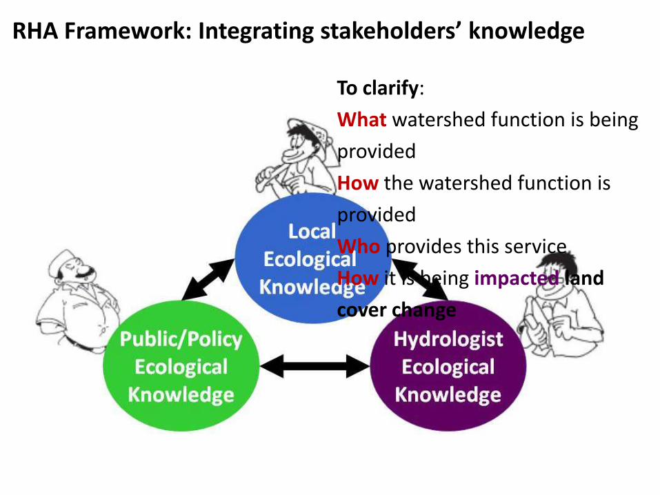
RHA Framework: Integrating stakeholders’ knowledge
To clarify:
What watershed function is being
provided
How the watershed function is
provided
Who provides this service
How it is being impacted land
cover change

1. Land cover/land cover change analysis
Land Cover Proportion
in Singkarak Basin
15%
1%
12%
5%
15%17%
1%
2%
8%
11%
13%
Forest
Pine
Mix garden
Mix garden (coconut)
Agricultural fields
Ricefield
Shrub
Grass
Settlement
Water body
No data (cloud and shadow)
Information on distribution of land cover, historical use

2. Stakeholder analysis
Stakeholder Male farmers Female farmers Local government Non-government
Composition From jorong (village) Subarang, Parumahan, Gando.
From jorong (village) Koto Baru, Kampuang Tangah.
Head of Jorong, Planning Agency: BPN (Badan Perencanaan Nagari), PLTA (HEP, Hydro Electric Power), BP-DAS Province
Bundo Kanduang, Majelis Ulama Nagari, Karapatan Antar Nagari.
Stakeholder groups in Nagari Paninggahan, Singkarak
Who is involved, who is affected by the watershed
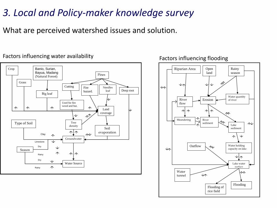
What are perceived watershed issues and solution.
3. Local and Policy-maker knowledge survey
Pines
Needles leaf
Fire
hazard.
Cutting
Deep root
Land
coverage
Soil evaporation
Groundwater
Water Source
Used for fire
wood and hut.
Tree density
Banio, Surian, Bayua, Madang
(Natural Forest)
Big leaf
Crop
Grass
Season
Type of Soil
Dry
Rainy
Dry
Rainy
Clay
Limestone
Factors influencing water availability
Water holding capacity on lake
Riparian Area
River flow
Meandering
Water tunnel
Open
land
Flooding
Lake water surface
Lake sediment
Erosion Water quantity of river
Rainy
season
River sediment
Flooding of
rice field
Outflow
Factors influencing flooding

4. Modelling landscape hydrology
What is the effect of land cover? Rainfall?
on Landscape water balance? Hydro electric power performance?
0
0.1
0.2
0.3
0.4
0.5
0.6
0.7
0.8
0.9
1
50% less
rain
25% less
rain
Default
rainfall
25% more
rain
50% more
rain
Perf
orm
an
ce H
EP
P
Best year
Mean
Worst year
0.5
0.55
0.6
0.65
0.7
0.75
0.8
0.85
0.9
0.95
1
Cu
rren
t L
U
mix
Deg
rad
. _ a
ll
Deg
rad
. _
Lakesid
e
Sev.D
eg
rad
.
_ L
akesid
e
Deg
rad
. _
Pan
ing
ah
an
Sev.D
eg
rad
.
_
Pe
rfo
rma
nc
e H
EP
P
0.5
0.55
0.6
0.65
0.7
0.75
0.8
0.85
0.9
0.95
1
Nat.Forest _
all
Nat.Forest _
Lakeside
Nat.Forest _
Paningahan
Current LU
mix
Pe
rfo
rma
nc
e H
EP
P
0.50.550.6
0.650.7
0.750.8
0.85
0.90.95
1
Pin
us ref
ore
stat
ion
_ al
l
Pin
us ref
ore
stat
ion
_ La
kesi
de
Pin
us ref
ore
stat
ion
_ Pan
ingah
an
Cur
rent
LU m
ix
Perf
orm
an
ce H
EP
P

Declining water quality due to erosion reduced ‘ikan bilih’
Sedimentation and erosion threatened PLTA
Flooding caused by deforestation
Intensive agriculture & deforestation caused insufficiency of water yield for PLTA
Reforestation to reduce erosion and increase water availability
Declining water quality due to erosion reduced ‘ikan bilih’
Sedimentation and erosion threatened PLTA
Flooding caused by deforestation
Intensive agriculture & deforestation caused insufficiency of water yield for PLTA
Reforestation to reduce erosion and increase water availability Disappearance of ‘ikan bilih’ due to decreasing water quality and overfishing
Reduction of water quality will also influence the performance of PLTA (euthrophication)
Declining water quality due to erosion reduced ‘ikan bilih’
Sedimentation and erosion threatened PLTA
Flooding caused by deforestation
Intensive agriculture & deforestation caused insufficiency of water yield for PLTA
Reforestation to reduce erosion and increase water availability
Climatic variation influences the performance of PLTA more than land use change
5. Integrating and reconciling local, policy-maker and scientific knowledge Perceived watershed issues and solution

Reforestation to reduce erosion and increase water availability
Reforestation of ‘critical land ‘ will not be enough to increase water yield & may actually reduce water yield due to increase in evapotranspiration
5. Integrating and reconciling local, policy-maker and scientific knowledge

Implication of RHA oucomes?
Before RHA: Reward scheme focused on HEPP as buyer and reforestation as the main activity to increase water availability
After RHA: Rewad schemes are multi-scales. Target buyer becomes wider and the objectives of watershed management are maintaining water flow as well as water quality

Reward scheme activities in Singkarak - multiscales
Nagari Paninggahan
Watershed Scale : 12 Nagari around Lake Singkarak (Selingkar Danau) form a grup and commited to manage watershed functions & to develop management plan with provincial environmental department for submisiion to the Ministry of Environment

Nagari/District Scale: 1. Ecocertification of organic coffee 2. Voluntary Carbon Mechanism – small scale
Reward scheme activities in Singkarak - multiscales

Where have we applied the carbon, agro-biodiversity and hydrological appraisal tools?
Potentially in other region as well ..