Sedimentation of Compressible Materials ... Sedimentation Cu
Upload
truonghanhCategory
view
220download
0
Sedimentation and basin-fill history of the Neogene clastic
succession exposed in the southeastern fold belt of the
Bengal Basin, Bangladesh: a high-resolution sequence
stratigraphic approach
M. Royhan Gani1, M. Mustafa Alam*
Department of Geology, University of Dhaka, Dhaka 1000, Bangladesh
Received 12 July 2000; received in revised form 2 April 2001; accepted 13 March 2002
Abstract
The Tertiary basin-fill history of the Bengal Basin suffers from oversimplification. The interpretation of the sedimentary
history of the basin should be consistent with the evolution of its three geo-tectonic provinces, namely, western, northeastern
and eastern. Each province has its own basin generation and sediment-fill history related mainly to the Indo-Burmese and
subordinately to the Indo-Tibetan plate convergence. This paper is mainly concerned with facies and facies sequence analysis of
the Neogene clastic succession within the subduction-related active margin setting (oblique convergence) in the southeastern
fold belt of the Bengal Basin. Detailed fieldwork was carried out in the Sitapahar anticline of the Rangamati area and the
Mirinja anticline of the Lama area. The study shows that the exposed Neogene succession represents an overall basinward
progradation from deep marine through shallow marine to continental–fluvial environments. Based on regionally correlatable
erosion surfaces the entire succession (3000+ m thick) has been grouped into three composite sequences C, B and A, from
oldest to youngest. Composite sequence C begins with deep-water base-of-slope clastics overlain by thick slope mud that passes
upward into shallow marine and nearshore clastics. Composite sequence B characteristically depicts tide-dominated open-
marine to coastal depositional systems with evidence of cyclic marine regression and transgression. Repetitive occurrence of
incised channel, tidal inlet, tidal ridge/shoal, tidal flat and other tidal deposits is separated by shelfal mudstone. Most of the
sandbodies contain a full spectrum of tide-generated structures (e.g. herringbone cross-bedding, bundle structure, mud couplet,
bipolar cross-lamination with reactivation surfaces, ‘tidal’ bedding). Storm activities appear to have played a subordinate role in
the mid and inner shelf region. Rizocorallium, Rosselia, Planolites and Zoophycos are the dominant ichnofacies within the
shelfal mudstone. This paralic sedimentation of Neogene succession in the study area can serve as a good point of reference for
tide-dominated regressive shelf depositional systems. The top of the composite sequence B is marked by a pronounced erosion
surface indicating the final phase of marine regression followed by the gradual establishment of continental–fluvial
depositional systems represented by composite sequence A. In this composite sequence, stacked channel bars of low-sinuosity
braided rivers gradually pass upsequence into high-sinuosity meandering river deposits.A sequence stratigraphic approach has
been adopted to interpret the basin-fill history with respect to relative sea-level changes; and to subdivide the rock record into
several sequences and units (systems tracts and parasequences) based on identified bounding discontinuities, such as
transgressive erosion surface (TES), regressive erosion surface (RES), marine flooding surface (MFS), and incised valley floor
0037-0738/02/$ - see front matter D 2002 Elsevier Science B.V. All rights reserved.
PII: S0037 -0738 (02 )00182 -3
* Corresponding author.
E-mail addresses: [email protected] (M. Royhan Gani), [email protected] (M. Mustafa Alam).1 Present address: Geoscience (FO 21), University of Texas at Dallas, 2601 North Floyd Road, Richardson, TX 75038-0688, USA.
www.elsevier.com/locate/sedgeo
Sedimentary Geology 155 (2003) 227–270

(IVF). This approach provides new insight for both exploration and exploitation strategy for hydrocarbon plays that may prove
vital to the oil companies engaged in exploration activities in the Bengal Basin. It is strongly recommended here that the
traditional lithostratigraphic classification of this part of the basin, which is based on the Assam stratigraphy, be abandoned or at
least revised. A tentative allostratigraphic scheme is presented, and it is suggested that to formalize the scheme further study,
both surface and subsurface, is needed.
D 2002 Elsevier Science B.V. All rights reserved.
Keywords: Bengal Basin; Neogene; Lithofacies; Facies analysis; Bounding discontinuity; Sequence stratigraphy
1. Introduction
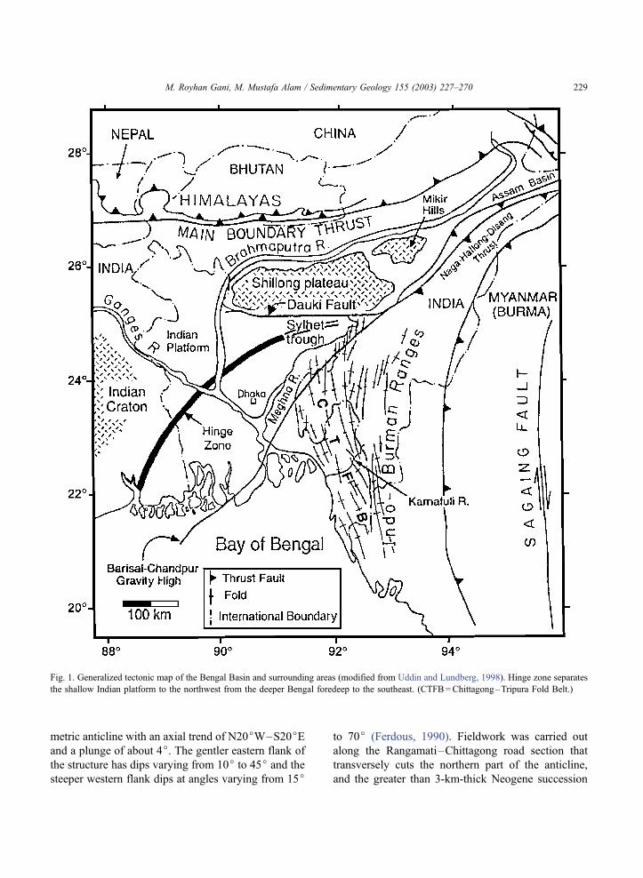
The Bengal Basin, covering Bangladesh and part
of eastern India, is one of the least studied and known
basins in the world. The geological evolution of the
basin began in the late Mesozoic with the break-up of
Gondwanaland and is ongoing (Alam, 1989). The
greater Bengal Basin is bounded by the Shillong
Plateau, the northeastern wedge of the Indian craton,
to the north; by exposures of the Indian craton to the
west; and by the Indoburman Ranges to the east (Fig.
1). The basin extends southward into the Bay of
Bengal.
The Bengal Basin is well known for the develop-
ment of one of the thickest (about 20 km) sedimentary
successions in the world. A considerable thickness of
the Neogene clastic strata is exposed in the Chitta-
gong–Tripura Fold Belt (CTFB) along the eastern
margin of the basin. However, only few publications
have presented facies analysis of these clastic rocks
exposed in the southern part of the CTFB (Alam,
1995; Alam and Ferdous, 1995, 1996; Alam and
Karim, 1997; Gani and Alam, 1999). The significance
of tidal influence in the shallow marine Surma Group
(Table 1) was first discussed by Alam (1995). More
recently Gani and Alam (1999) have suggested that
the entire Surma Group succession represents an
overall basinward progradation from deep marine to
coastal marine within the active margin setting of the
Indo-Burmese plate convergence.
This study is a follow-up of the work of Gani
(1999) and Gani and Alam (1999), and has six main
objectives: (1) to carry out a detailed lithofacies
analysis and palaeoenvironmental reconstruction of
the Neogene clastics (focusing on the traditional
Surma Group) exposed in the southeastern fold belt;
(2) to provide a full record of the entire exposed
succession for continuous tracking of the basin-fill
history from oldest to youngest; (3) to divide the rock
record on the basis of bounding discontinuities using
the conceptual framework of high-resolution sequence
stratigraphy; (4) to interpret the origin of, and genetic
relationships between, individual units in response to
relative sea-level changes; (5) to present a regional
correlation (depositional-strike parallel) of the identi-
fied bounding discontinuities between the two studied
anticlines; and (6) to propose a tentative revised
stratigraphic framework for the CTFB.
These objectives imply that this study is significant
in terms of local as well as international perspective.
For example, the study may shed light on the tidal
deposits of regressive shelves that are yet to be well
documented and modeled. The anatomy of the sand-
bodies presented here can be valuable to international
oil companies for accurate stratigraphic prediction of
reservoir facies and trapping styles. Furthermore, the
revised stratigraphic scheme proposed in this study
can be significant for a better understanding of the
sedimentary evolution of the CTFB region.
Fieldwork was carried out in two anticlinal struc-
tures within the CTFB, namely, the Sitapahar anticline
of the Rangamati area and the Mirinja anticline of the
Lama area (Fig. 2). The Mirinja structure, about 120
km long and extending southward into Mayanmar, is a
doubly plunging, elongated asymmetric anticline with
an axial trend of N35jW–S35jE and a plunge of 7jtoward N35jW. The eastern flank of the structure is
steeper and the axial plane dips 82j toward S56jW.
Detailed logging was carried out to document a nearly
3-km-thick Neogene clastic succession exposed along
the Lama–Fasiakhali road section in the western flank
of the structure. Rocks exposed in various creeks
along the Matamuhari River and on the eastern flank
of the structure have also been studied for cross-
checking. The Sitapahar structure, about 40 km in
length, is also a doubly plunging, elongated asym-
M. Royhan Gani, M. Mustafa Alam / Sedimentary Geology 155 (2003) 227–270228
metric anticline with an axial trend of N20jW–S20jEand a plunge of about 4j. The gentler eastern flank of
the structure has dips varying from 10j to 45j and the
steeper western flank dips at angles varying from 15j
to 70j (Ferdous, 1990). Fieldwork was carried out
along the Rangamati–Chittagong road section that
transversely cuts the northern part of the anticline,
and the greater than 3-km-thick Neogene succession
Fig. 1. Generalized tectonic map of the Bengal Basin and surrounding areas (modified from Uddin and Lundberg, 1998). Hinge zone separates
the shallow Indian platform to the northwest from the deeper Bengal foredeep to the southeast. (CTFB=Chittagong–Tripura Fold Belt.)
M. Royhan Gani, M. Mustafa Alam / Sedimentary Geology 155 (2003) 227–270 229
exposed on the eastern flank has been described in
detail.
2. Regional tectonics and stratigraphy
Understanding the tectonic setting of a region is a
necessary pre-requisite to understand the paleogeo-
graphic and sedimentation patterns of that region. The
tectonic framework and structural setting of the Ben-
gal Basin has been discussed by several authors
including some of the important recent accounts of
Murphy and Staff BOGMC (1988), Lohmann (1995),
Alam (1997), and Sikder (1998).
Various independent lines of evidence demonstrate
that the Indian plate was subducting below both the
Tibetan plate to the north and the Burmese plate to the
east during the greater part of the Tertiary. Gani and
Alam (1999) have reviewed the tectonic concepts of
southeast Asia and have offered a somewhat modified
tectonic setting for the CTFB. They have proposed
that the CTFB is a westward extension of the Indobur-
man Ranges and is closely related to the easterly
subduction of the Indian plate in an arc-trench tectonic
setting (Fig. 3). The CTFB region in the very early
Neogene was a remnant ocean basin and included the
migrated trench-slope bathymetry from the east. This
remnant ocean basin received sediment from two
directions—(i) collision-derived sediment from the
Barail and Naga Hills entering the basin from the
north along the trench axis and (ii) Indoburman arc-
derived sediment shed transversely to the trench from
the east. The trench axis has shifted further westward
and southward because of this heavy sediment load-
ing, giving rise to the Neogene accretionary prism
(Fig. 3) of Dasgupta and Nandy (1995). It is remark-
able that in the southeastern part of the Bengal Basin
the trench-slope bathymetry was flattened to shallow-
water conditions probably sometime in the Late Mio-
cene. At present the deep-water subduction zone
exists only southward from approximately 19jN lat-
itude as the Andaman–Sunda Trench.
Evans (1932) established a lithostratigraphic clas-
sification for the Tertiary strata exposed in the Lower
Assam Basin (see Fig. 1 for geographic location).
Since then in various published and unpublished
reports, without any detailed regional correlation,
this early stratigraphy has served as the basis for
stratigraphic correlation of the sediments within the
entire Bengal Basin. Later studies using micropa-
leontology (e.g. Banerji, 1984), palynology (e.g.
Baksi, 1972; Reimann, 1993), and seismic stratigra-
phy (e.g. Salt et al., 1986; Lindsay et al., 1991) have
partly refined this early scheme. Uddin and Lund-
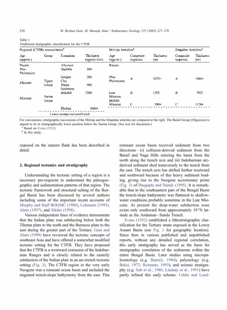
Table 1
Traditional stratigraphic classification for the CTFB
For convenience, stratigraphic successions of the Mirinja and the Sitapahar anticline are compared at the right. The Barail Group (Oligocene) is
argued to lie in stratigraphically lower position below the Surma Group. (See text for discussion.)a Based on Evans (1932).b In this study.
M. Royhan Gani, M. Mustafa Alam / Sedimentary Geology 155 (2003) 227–270230

berg (1999) have given a relatively in-depth sum-
mary of the stratigraphy of the Bengal Basin and
have discussed the depositional pattern of the Surma
Group in the eastern Bengal Basin using subsurface
lithofacies maps. Table 1 shows the old stratigraphic
nomenclature traditionally used for the CTFB region.
Fig. 2. Geological sketch map of part of the Chittagong–Tripura Fold Belt (CTFB) showing the distribution of the traditional stratigraphic units
(modified from Alam et al., 1990). Note the locations of the studied anticlines and the seismic profile in Fig. 29.
M. Royhan Gani, M. Mustafa Alam / Sedimentary Geology 155 (2003) 227–270 231

Fig. 3. Tectonic setting of the Bengal Basin within the regional context (from Gani and Alam, 1999). The Tertiary volcanic centers are marked
by solid dots and the bathymetric contours of the Bay of Bengal are shown in meters. (NAP=Neogene accretion prism.)
M. Royhan Gani, M. Mustafa Alam / Sedimentary Geology 155 (2003) 227–270232

The base of the Surma Group as well as the contact
between the Bhuban and Bokabil formations in this
Group is not well defined in this region, highlighting
the need for a revised stratigraphic scheme.
3. Sedimentology and sequence stratigraphy of the
Neogene succession
Detailed sedimentological logging of the exposed
sections permits identification of the facies types and
bounding discontinuities within the Neogene clastic
succession in the studied anticlines. The criteria for
identifying the bounding discontinuities are primarily
based on the principles of high-resolution sequence
stratigraphy, and are briefly discussed here first.
Incised valley floor (IVF)—This surface erodes the
upper part of a progradational succession at best, and
shelfal mud at worst; and the lag deposits indicative of
channel erosion characteristically overlie it. The suc-
cession overlying this surface reveals deepening-
upward (transgressive) trend, in which typical estuar-
ine facies can be identified. The above criteria suggest
that this bounding discontinuity most probably devel-
oped as a result of channel incision at the time of sea-
level low; and hence is called an IVF.
Regressive erosion surface (RES)—It is developed
erosionally on shelfal mud and is overlain by shallow-
ing-upward shoreface deposits. This type of bottom-
truncated progradational shoreface deposits indicates
that the surface lying below has been generated
because of submarine erosion during the fall of relative
sea level; and hence the surface is designated as a RES.
Transgressive erosion surface (TES)—This surface
exclusively develops on valley-fill deposits experienc-
ing sea-level rise. It is overlain by either thin (5–15-
cm-thick) pebble horizon or 5–10-m-thick shoreface
sandbody before passing upward into shelfal mud. The
above criteria suggest that this surface has been devel-
oped because of submarine erosion during the rise of
relative sea level; and hence can be called a TES.
Transgressive surface (TS)—This surface is similar
to the TES except that it is non-erosional and is
directly overlain by shelfal mud. It should be noted
that subtle TSs are inferred to exist at the contact
between the fluvial and estuarine deposits within a
valley-fill succession. These will be discussed later in
the text.
Marine flooding surface (MFS)—This type of
bounding discontinuity is formed when shelfal mud
abruptly overlies a shallowing-upward shoreface suc-
cession. Therefore, it is the result of a short-term sea-
level rise; and hence is called a MFS.
On the basis of the earlier works (Alam, 1995;
Alam and Ferdous, 1995, 1996; Gani, 1999; Gani and
Alam, 1999), it can be concluded that the exposed
Neogene succession in the CTFB represents a basin-
ward progradation from deep marine base-of-slope
through shallow marine coastal to continental–fluvial
deposits; and that the entire succession may be
divided into three broad groups. In this study, we
have established three discrete composite sequences
based on the regionally correlatable bounding discon-
tinuities (Fig. 4). These composite sequences, desig-
nated as C, B, and A, from oldest to youngest,
represent three stages of basin evolution each having
its own sedimentation pattern and basin-fill architec-
ture. A comparison of the three composite sequences
with the traditional stratigraphic nomenclature is
shown in Table 1.
(i) Composite sequence C (1128 +m thick): The
basal composite sequence is conspicuously mud
dominated with minimal development of intervening
erosion surfaces. It begins with deep-water base-of-
slope clastics, encountered only in the Sitapahar
anticline (Fig. 4B), that grade upward into shallow
marine and nearshore deposits. Prograding parase-
quences separated by MFSs characterize this compo-
site sequence in the Sitapahar anticline, whereas in the
Mirinja anticline submarine channel deposits are con-
spicuous (Fig. 4A). The top of C is demarcated by a
pronounced erosion surface indicating a lowstand of
sea level.
(ii) Composite sequence B (1293+ m thick): The
middle composite sequence is sand dominated and has
several distinct and regionally traceable erosion sur-
faces. It is abbreviated in the Sitapahar anticline due to
truncation by the Manikchari fault (Fig. 4B). Tide-
dominated open marine shelfal to coastal depositional
settings under the control of cyclic relative sea-level
rise and fall typify this composite sequence, where
several incised valley-fill deposits are prominent. The
top of B is also a pronounced erosion surface of
lowstand sea level.
(iii) Composite sequence A (1080+ m thick): The
upper composite sequence represents the final phase
M. Royhan Gani, M. Mustafa Alam / Sedimentary Geology 155 (2003) 227–270 233

of basin-filling history with the establishment of
continental–fluvial depositional systems. Low-sinu-
osity braided to high-sinuosity meandering fluvial
deposits characterize a considerable portion of this
composite sequence.
On the basis of the overall regional tectonic setting
discussed in Section 2, it is assumed that the trend of
paleo-coastline in the CTFB was oriented north–
south. Alam (1995) documented a similar paleo-coast-
line trend from paleocurrent analysis of the Surma
Group in the Sitapahar anticline. The measured cur-
rent directions in Fig. 4 represent landward (eastward)
and basinward (westward) directions.
In the lithostratigraphic columns (Fig. 4) we have
shown the sequences of different hierarchies. Within a
composite sequence individual sequences represent a
single sea-level cycle (fall–rise–fall). As a result,
either IVF or RES bound them (both below and on
top). When completely developed and/or preserved
they show all the three systems tracts—lowstand,
transgressive and highstand—of an ideal sequence.
Each sequence is further subdivided into units based
on TES/TS and MFS. A unit therefore, in most cases,
represents a systems tract (separated by a TES/TS) or
a parasequence (separated by a MFS).
3.1. Composite sequence C
The lower composite sequence represents a basin-
ward progradation from deep marine (base-of-slope
deposits) to shallow marine clastics. The base-of-
slope deposits are observed only in the Sitapahar
anticline.
3.1.1. Mirinja anticline
Unit Ca: Monotonous laminated mud with paper-
thin discontinuous silt-streaks, and a few scattered
burrows (Zoophycos, Planolites and others unidenti-
fied) comprise the lower part of unit Ca. Micropa-
leontological study revealed several foraminiferal
tests (e.g. Rotalia, Quinqueloculina). Above the bush
cover, silt lenses, mostly with gradational bases and
sharp tops, increase in number within the mud. Ripple
cross-lamination within these lenses shows an east-
ward (landward) current direction. Rare thin ( < 5 cm
thick) and sharp-based siltstone to very fine sandstone
interbeds, either structureless or containing combined-
flow ripple-lamination, were observed. Just below
unit Cb, the number of burrows (Rizocorallium,
Rosselia, Planolites and Zoophycos) increases
abruptly.
This oldest stratigraphic interval is interpreted as
very outer-shelf mud grading upward into distal inner-
shelf silty mud indicating a shallowing-upward trend.
The quiet water shelf environment is occasionally
interrupted by storm events that deposited the sharp-
based thin siltstone and sandstone interbeds and lenses
(e.g. MacEachern et al., 1998). The trace fossil
association also substantiates this environmental inter-
pretation.
Unit Cb: This unit is 27 m thick and begins on an
erosional surface (Fig. 5A). The lower 10 m of this
unit has repetitive 10–20-cm-thick fining-upward
cycles (Fig. 5B). In each cycle the thickness of mud
intervals increases upward and the silt intervals show
parallel to truncated wavy lamination reflecting hum-
mocky cross-stratification. The lower part of the unit
passes upward (through a thin interval of wavy-
lenticular sand–mud) into a dominantly medium to
fine sandy succession, which contains trough cross-
bedding (Fig. 6), megaripple cross-stratification, thin
intercalated irregular mud laminae and scattered mud
clasts, up to 15 cm in size. The top 6 m of the unit is
composed of interbedded sandstone and mudstone.
The fine to very fine, ripple cross-laminated sandstone
interbeds abruptly decrease in thickness from 20 cm to
a few centimeters up-sequence. The laminated mud-
stone interbeds contain small sand lenses with oppos-
ing current directions.
The lower part of the unit is interpreted as waning
storm-generated fining-upward succession (Fig. 5B),
where storm influence decays upsequence. The mid-
dle part is thought to represent progradation of a tidal
sand sheet/sand wave (in the sense of Stride et al.,
1982), which may have been partially modified by
storm activity. Thin mud drapes along the foresets and
set boundary (Fig. 6), and occurrence of intercalated
mud laminae attest to this tidal influence. It is evident
that the lower and middle part of unit Cb indicate a
shallowing-upward trend. The unit rests erosionally
on inner shelf mud, indicating that this erosion surface
is probably a RES, and that the unit represents a
‘sharp-based’ shoreface sandbody (cf. Plint, 1988)
produced because of relative sea-level fall. Abrupt
thinning and muddier upward trend within the top 6 m
of unit Cb indicates progressive deepening (after a
M. Royhan Gani, M. Mustafa Alam / Sedimentary Geology 155 (2003) 227–270234

Fig. 4. Details of the lithostratigraphic column of the exposed Neogene clastic succession with bounding discontinuities and tentative regional correlation. (A) The Mirinja anticline and (B) the Sitapahar anticline.
M. Royhan Gani, M. Mustafa Alam / Sedimentary Geology 155 (2003) 227–270 pp. 235–240

Fig. 5. (A) Detailed litho-log of the first shoreface sandbody (unit Cb in the Mirinja anticline) on shelfal mud; and (B) one representative storm-
generated fining-upward cycle (in the lower 10 m of the unit) characterized by: (a) scoured to load casted fine (to medium) massive sandstone
with mudstone clasts, (b) hummocky to parallel laminated siltstone, (c) mudstone with injection structures.
M. Royhan Gani, M. Mustafa Alam / Sedimentary Geology 155 (2003) 227–270 241

sea-level fall), the culmination of which is considered
as a TS.
The remaining part of composite sequence C is
mud dominated with three sand intervals. For con-
venience these three sand intervals are designated as
units Cc, Cd, and Ce, although this does not comply
with the criteria adopted for designating other units
in Fig. 4. Laminated mudstone with rare continuous
to discontinuous silt laminae and sharp-based lenses,
with rare low-angle micro cross-lamination, charac-
terize the muddy interval between units Cb and Cc.
A few massive to parallel laminated and sharp-based
20–50-cm-thick silt beds occur below the base of
unit Cc.
Unit Cc: This is a 25-m-thick deposit with basal
erosional relief traceable for more than 10 m. The
deposit is fine to medium sand with high matrix
content and structureless appearance. Conglomeratic
lags with some erratic lithic blocks up to 1 m long
occur above the erosional base. Shells and impres-
sions of bivalve fossils are occasionally encountered
within the deposit. Considering the overall rock con-
text of this part of composite sequence C, the unit Cc
is interpreted to represent a submarine gully/channel
filled chaotically and encased within the upper bathyal
mudstone. The laminated fissile mudstone above unit
Cc contains paper-thin silt streaks. The amount of silt
increases abruptly below unit Cd.
Unit Cd: This unit is 12 m thick and is charac-
terized by repetitive fining-upward cycles 10–20 cm
thick (Fig. 7) of ripple cross-laminated very fine
sandstone grading up into intercalated silt-mudstone
and shale. Each cycle has a sharp base with load and
injection structures. Numerous meandering trails
(Scolicia or Cochlichnus?), some crosscutting, are
preserved at the base of some of the sandstone beds
(Fig. 8). A 1.5-m-thick slumped bed including folded
thin sandstone beds occurs in the middle part of this
unit. The fining-upward cycles (Fig. 7) are not clear in
terms of their exact physiographic position of depo-
sition. However, in terms of their generative mecha-
nism it is probable that each cycle has been deposited
under a single pulse of waning current. Ripple lami-
nation within sandstone intervals resembles combined
flow ripples described by Myrow and Southard
(1991), and hence is indicative of storm activity.
However, the slump bed within this unit may be
indicative of slope instability of the upper bathyal
environment, hence suggesting some turbidity current
activity.
Above unit Cd, for some distance upward, thin
( < 10 cm) very fine, ripple cross-laminated sandstone
Fig. 6. Details of trough cross-bedding at the upper part of unit Cb in the Mirinja anticline.
M. Royhan Gani, M. Mustafa Alam / Sedimentary Geology 155 (2003) 227–270242
beds with fining-upward trends and ending into
mudstone, are rarely present within the mudstone.
These beds are thought to have been deposited du-
ring unusual high tide and/or storm conditions.
Below unit Cd the mudstone is highly fissile with
silt streaks and lenses.
Unit Ce: This unit has been described earlier by
Gani and Alam (1999) and interpreted as a well-
developed and shelf-breaching submarine channel
filled with 15+-m-thick turbidities (Fig. 9). The
channel is laterally traceable along strike for over
200 m as multiple-stepped erosional feature (Fig.
Fig. 7. Repetitive fining-upward cycles in unit Cd in the Mirinja anticline. One of the cycles is represented by the scale-length (15 cm). See text
for explanation.
Fig. 8. Numerous meandering trails of trace fossil (Scolicia or Cochlichnus?) preserved at the base of a sandstone bed showing fining-upward
trend (Fig. 7) in unit Cd in the Mirinja anticline (coin for scale is 2.2 cm in diameter).
M. Royhan Gani, M. Mustafa Alam / Sedimentary Geology 155 (2003) 227–270 243
10) with relief of about 12 m. Orientation of the
channel wall is roughly east–west and current
direction within the channel-fill turbidites is toward
the west. Repetitive occurrence of thick-bedded
(average 60 cm) coarse silt to very fine sandstone
with characteristic water-escape structures, such as
internal convolution, network of dish and pillar
structures, water-escape pipes, characterizes the lo-
wer part of the channel-fill deposits. The upper part
of the channel-fill consists of an alternation of
thick-bedded (average 1 m), fine to medium, mas-
sive sandstone containing some water-escape struc-
tures at the top, and thin-bedded (average 15 cm)
muddy silt with a few water-disruption marks (Fig.
11). A few of these beds show partial amalgama-
tion. Some thin-bedded (10 to 20 cm) partial to
nearly complete Bouma sequences occur at the chan-
nel margins.
The genetic stratigraphic interpretation of ‘sharp-
based’ shoreface sandbodies (cf. Plint, 1988) has
been much debated in geological literature and will
be discussed later. In the present study the RES is
thought to have been generated by submarine ero-
sion due to forced regression (Posamentier et al.,
1992). Whether the deposits overlying the RES
should be considered as forced regressive systems
tract of Hunt and Tucker (1992) or lowstand sys-
tems tract of Posamentier et al. (1992) may be dif-
ficult to determine, and needs data from further
basinward (MacEachern et al., 1999). In our case,
for convenience, we have assigned the sandbody
resting on RES to a lowstand systems tract in a
broad sense. In this regard the combined lower and
middle part of unit Cb of composite sequence C
may be considered a lowstand systems tract, which
is overlain by a very thin and subtle transgressive
systems tract indicated by the deepening-upward
trend in the upper 6 m of unit Cb. However, as
the RES below unit Cb is not regionally correlatable
(Fig. 4), it is not considered here as a sequence
boundary. The rest of composite sequence C repre-
sents highstand systems tract without containing any
highstand parasequence of shoreline progradation.
The submarine channels within this part of the
composite sequence do not necessarily indicate
any sea-level fall; rather they, especially the upper-
most shelf-breaching and mature submarine channel
(Fig. 10), indicate littoral sediment capturing and
Fig. 9. Litho-log of the channel-fill turbidites (unit Ce in the Mirinja
anticline), measured from the N–S face (Fig. 10) of the channel.
See text for explanation.
M. Royhan Gani, M. Mustafa Alam / Sedimentary Geology 155 (2003) 227–270244
by-passing into deep basin during highstand con-
dition (e.g. Kolla and Perlmutter, 1993).
3.1.2. Sitapahar anticline
In the Sitapahar anticline there is also no identifi-
able erosional sequence boundary within the compo-
site sequence C. A distinct progradation from base-of-
slope deep-sea clastics to shallow marine clastics is
reflected by the rock succession of this composite
sequence. Gani and Alam (1999) gave a detailed
description of the facies types and depositional envi-
ronments represented by units Ca and Cb. Only a brief
interpretation of the depositional scenario of these two
units is presented below.
Units Ca and Cb: Thin packages of turbidites
(mostly partial Bouma sequences), together with some
slump and debris-flow deposits contained within
thicker intervals of hemipelagic mudstone, character-
ize the base-of-slope deposits of unit Ca. Small-scale
submarine lobe, channel–levee complex (Fig. 12) and
Fig. 10. Outcrop attitude of the submarine channel Ce (in the Mirinja anticline) represented by block diagram.
Fig. 11. Alternation of thick-bedded massive sandstone and thin-bedded muddy siltstone at the upper part of the turbidite-fill channel Ce in the
Mirinja anticline. Note hammer for scale at the center of the photo (see also Fig. 9).
M. Royhan Gani, M. Mustafa Alam / Sedimentary Geology 155 (2003) 227–270 245

debris–mass complex represent some of the architec-
tural elements within this unit. The deposits of the unit
can tentatively be assigned to the ‘slope fan’ element
of lowstand systems tract in the sense of Van Wagoner
et al. (1988). However, at present there is no con-
clusive evidence for this interpretation; and the unit
may well be a part of the highstand systems tract
continuous with the overlying systems. The lower half
of unit Cb is composed of monotonously muddy slope
deposits that contain some localized intervals of very
thin-bedded turbidites. The upper half of the unit
represents shoaling-upward shallow marine sedimen-
tation with thicker shelfal mudstone passing strati-
graphically upward into distinct tidal ridge pro-
gradation (Fig. 13) followed by a coastal deposit. This
coastal deposit mainly reflects progradation and retro-
gradation of tidal flat strata coupled with some ripple
cross-laminated to structureless (may be storm-
reworked), fine-grained sandstone intervals. The top
of the unit is marked by a distinct MFS.
Unit Cc: This is a 34-m-thick unit characterized
by a coarsening-then fining-upward trend. The lower
part consists of interlaminated very fine sandstone
and mudstone that are gradationaly overlain by
structureless (to bedded) fine sandstone. The top
10 m of the unit reveals a muddier-upward trend
with interlaminated very fine sandstone and mud-
stone, passing upward into laminated mudstone.
Although the sedimentary structures within sand-
stone are not very clear, the sedimentation pattern
of this unit may be explained by progradation of a
sand bar (tidal?) on shelfal mud followed by trans-
gression without any development of nearshore de-
posits. Since the top part of unit Cc indicates a
deepening-upward trend the upper boundary of this
unit is interpreted as a MFS.
Unit Cd: Thick laminated mudstone with occa-
sional sandstone beds (a few centimeters thick) char-
acterize the lower 90 m of this unit, which passes up-
sequence into a 72-m-thick interval of monotonously
repetitive alternations of thin bedded sandstone and
mudstone. The two end-member interbeds are ripple-
laminated very fine sandstone 5–10 cm thick and
laminated mudstone 2–3 cm thick that are gradational
into each other through a 3–5-cm-thick wavy silt-mud
interval. This type of sedimentation pattern distinctly
reflects cyclic variation in sand–mud content within
the deposit. The top 20 m of unit Cd reflects a
muddier upward trend with the cyclic pattern gradu-
ally disappearing upward. A subtle MFS can be
recognized at the top. The monotonous alternation
of mudstone and sandstone in the upper part of this
Fig. 12. Small-scale channel– levee complex grading up into hemipelagic mudstone at the upper part of the base-of-slope deposits of unit Ca in
the Sitapahar anticline. (Person at left for scale.)
M. Royhan Gani, M. Mustafa Alam / Sedimentary Geology 155 (2003) 227–270246

unit is interpreted as tidal rythmites in which the
cyclic variation of lithology is due to the neap-spring
variation in tidal cycle in the distal offshore setting.
Although similar types of tidal rythmites are common
in nearshore deposits, they have rarely been described
from a distal offshore depositional setting (e.g. Wil-
liams, 1989).
Unit Ce: The lower part of this unit consists of
monotonous laminated mudstone with sporadic silt
laminae, lenses, and a few sharp-based fine sandstone
beds (10 cm thick). In the upper part, laminated
mudstone gradually passes upward into interbedded
very fine sandstone 25 cm thick and mudstone 2–4
cm thick. This succession is overlain by repeated
fining-upward cycles, and is ultimately truncated by
an erosion surface. The individual fining-upward
cycles ( < 20 cm thick) belong to the continuum of
flaser-wavy-lenticular association (Reineck and Wun-
derlich, 1968). The nature of the laminated mudstones
at the lower part of Ce indicates that they are shelfal
muds, which are overlain by a coarsening-upward
facies succession. Although the sedimentary struc-
tures within the sandstone beds of this succession
are not discernable, the rhythmic alteration of thin
mudstone beds suggests that the succession may
reflect tidal ridge progradation on a regressive shelf
(e.g. Meckel, 1975; Dalrymple, 1992). The sedimen-
tary structures within the fining-upward cycles over-
lying this shallowing-upward succession justify tidal
flat progradation (e.g. Weimer et al., 1982; Alam,
1995).
This complete progradational succession of unit
Ce is erosionally overlain by an upward fining facies
succession with granule to pebble-sized mud intra-
clasts at the base. The lower 8 m of this succession
shows structureless medium (to coarse) sandstone
with thin mud interlaminae, whereas the upper 28 m
is characterized by an alternation of 10–20-cm-thick
very fine sandstone beds and 5-cm-thick mudstone
beds. This fining-upward succession is again trun-
cated by a 3-m-thick erosionally based upward
fining deposit of fine sandstone with mud intercala-
tion. A considerable thickness of this deposit may
have been eroded by the incised valley of the next
sequence. These two fining-upward successions (at
the top part of unit Ce) with heterolithic facies,
erosional bases, and basal lags give evidence for
tidal channel deposition (Shanmugam et al., 2000).
It may be argued that these deposits have been
generated by autocyclic lateral migration of tidal
channels (cf. Kumar and Sanders, 1974) on the
coastal plain at the final phase of gradual marine
regression.
Fig. 13. (a) Detailed litho-log of the first progradational sandbody
on shelfal mudstone at the upper part of unit Cb in the Sitapahar
anticline; and (b) one representative fining-upward cycle from the
lower 6.5 m of this sandbody. (From Gani and Alam, 1999).
M. Royhan Gani, M. Mustafa Alam / Sedimentary Geology 155 (2003) 227–270 247

The upper part of unit Cb and units Cc, Cd and Ce
represent progradational and shallowing-upward suc-
cessions each separated by a MFS. These deposits are
attributed to a single highstand parasequence set
consisting of four parasequences (sensu Van Wagoner,
1985; Van Wagoner et al., 1988).
3.2. Composite sequence B
This composite sequence develops five sequences
bounded by erosional surfaces (IVF or RES) of
predicted relative sea-level fall. The depositional
environments vary from shallow marine shelfal to
coastal settings punctuated by cyclic marine regres-
sion and transgression. Each sequence is divided into
units on the basis of bounding discontinuities of
relative sea-level rise.
3.2.1. Mirinja anticline
3.2.1.1. Sequence B1. Unit B1a: The unit begins on
a scoured surface overlain by 5-cm-thick intraforma-
tional lags consisting of numerous small mud rip-up
clasts ( < 5 mm in size). This is a monotonously
interstratified wavy-lenticular sandstone–mudstone
succession, which shows several muddier-upward
trends. Ripple cross-laminated (with some bipolarity)
very fine sandstone with thin mud drapes characterizes
the sandier portion, whereas the muddier portion is
laminated mudstone with a few sand lenticles. Sharp-
based, 3–5-cm-thick, very fine sandstone beds with
wave-rippled tops are rarely found within the unit.
The unit is thought to have been deposited in a
mixed wave- and tide-influenced shoreface setting
under the aegis of a slowly shifting coastline that
produced several muddier-upward trends. The setting
was probably away from a clastic input source, which
is supported by the lack of cross-bedded sandstone,
and the ripples that show predominantly eastward
(landward) current directions indicating a shelf source
of sediment transport. Since the shoreface deposits of
unit B1a erosionally rest on shelfal mud of the
composite sequence C, this scoured surface is
regarded as a RES. The generation of RES on tide-
dominated shelves is not well documented in the
geologic literature. The RES at the base of unit B1a
is believed to have been generated by subaqueous
tidal scouring in a shelfal setting during forced
regression (e.g. Reynolds, 1994). The unit grades up
into laminated mudstone at the top indicating a TS.
Unit B1b: The lower part of this unit is a muddy
succession with intercalated silt laminae and lenses
showing some sharp-based, low-angle, ripple cross-
lamination. The amount of silt increases upward and
silt becomes very fine sand before being dissected by
an erosion surface mantled by a 15-cm-thick, matrix-
supported conglomerate bed consisting of mud and
sand clasts. The sedimentation pattern of the rest of
the unit is chaotic compared to other units in this
anticline; yet two distinct intervals can be recognized.
The lower interval shows an indistinct upward coars-
ening trend. Interbedding of massive to ripple cross-
laminated fine sandstone (with thin mud laminae/
drapes) and wavy-lenticular sand–mud beds is typical
of most part of this interval, which is overlain by a 5-
m-thick fine to medium sandy succession character-
ized by low-angle accretion surfaces veneered by mud
clasts and rare wood fragments. This sandy succession
contains a 25-cm-thick set of trough cross-bedding
with tidal bundles (Fig. 14), flaser bedding, and
double mud drapes (mud couplets). On the other hand,
the dominant sedimentary structure in the upper
interval is ‘tidal-bedding’ of Reineck and Wunderlich
(1968) along with subordinate ripple cross-lamination
(with mud drapes, flasers) within the fine sandstone
interbeds. The uppermost 5 m of the unit shows a
repetition of distinct fining-upward cycles (average 20
cm thick) reflecting the continuum of flaser-wavy-
lenticular association.
The nature of the muddy succession at the lower
part of unit B1b indicates a distal offshore setting with
a slight upward shallowing trend before it is dissected
by an erosion surface, above which two sedimentation
intervals have been described. The lower interval
consists of coarsening-upward heterolithic facies suc-
cession beginning and ending with ripple cross-lami-
nated fine sand and trough cross-bedded medium
sand, respectively. This justifies that the succession
is a progradational sand bar deposit. Flaser structures,
thin mud drapes, mud couplets, and tidal bundles
indicate the tidal activity within the bar deposit.
Numerous modern and ancient examples of these
sedimentary structures in subtidal setting exist (e.g.
Alam, 1995; Visser, 1980; Allen, 1982; Nio and Yang,
1988; Shanmugam et al., 2000). Low-angle accretion
surfaces veneered by mud clasts found in the proximal
M. Royhan Gani, M. Mustafa Alam / Sedimentary Geology 155 (2003) 227–270248
bar deposits indicate a lateral migration of the tidal
bar. It is notable that the distal bar facies is missing or
at least abbreviated at the erosive base of the lower
interval. Therefore, it is likely that this erosion surface
is a RES resulting from tidal scouring due to forced
regression (similar to the RES below unit B1a).
However, this RES is not considered a sequence
boundary, since it is not regionally correlatable (see
discussion in Section 4.1). The sedimentary structures
and the small-scale fining-upward cycles in the upper
interval suggest tidal flat progradation (e.g. Alam,
1995; Klein, 1971). Therefore, these two sedimenta-
tion intervals together indicate a single continuous
shoaling-upward succession from lower shoreline to
coastal environments.
3.2.1.2. Sequence B2. Unit B2a: A typical fining-
then coarsening-upward facies succession (Figs. 4 and
15) characterizes most of unit B2a. The upward fining
succession begins on a distinct erosion surface with
basal lags consisting of mud clasts of variable sizes (a
few are as large as 1 m) dispersed in medium sand-
stone. In the lower 50 m of the succession poorly
sorted medium to fine sandstone with dispersed mud
pebbles are structureless in nature with rarely devel-
oped indistinct parallel lamination. This part of the
unit passes upward into finely laminated very fine
sandstone with well-developed parting planes. The
fining-upward succession culminates with laminated
siltstone and mudstone containing a few thin horizons
of organic-rich material and coal fragments. In the
upward coarsening succession the interlaminated silt-
mud portion grades up into very fine sand with ripple
cross-lamination, wavy mud interlaminae/drapes, and
rare flaser. This succession is truncated by an erosion
surface above which bi-directional ripple cross-lami-
nated very fine sandstone passes upward into repeated
fining-upward cycles (average 20 cm thick), within
each of which bipolar ripple cross-laminated very fine
sandstone containing mud drapes grades up into
laminated mud. A pronounced second erosion surface
veneered by mud pebbles (up to 25 cm long) appears
at the topmost part of unit B2a. A 7-m-thick deposit
above this erosion surface contains fine sandstone
with parallel to low-angle lamination and 5-mm-thick
stringers of medium sandstone.
The pronounced erosion surface with basal lags at
the base of unit B2a, and the typical tripartite facies
zonation of this unit (Fig. 15) can suitably be
described by an estuarine depositional model with
possible incision at the channel base. Incised valley
fills truncating the preceding highstand deposits with
Fig. 14. Tidal bundles (arrow) in the middle cross-bedded set of the photograph, from the middle part of unit B1b in the Mirinja anticline. Scale
bar at top left is 30 cm.
M. Royhan Gani, M. Mustafa Alam / Sedimentary Geology 155 (2003) 227–270 249

fining-then coarsening-upward trends are character-
istic in stratigraphic record (e.g. Leckie and Singh,
1991) and the bases of these fills are key sequence
boundaries in the Exxon model. Majority of the
deposits of unit B2a are typically structureless with
dispersed mud clasts that may be indicative of very
rapid aggradation and wave reworking of the valley-
fill deposit at the time of rising sea level. Intuitively,
therefore, either the valley acted as a zone of sediment
bypass during sea-level low and preserved little or no
fluvial deposits at the very lower part, or these low-
stand deposits were rapidly reworked during the
ensuing transgression (e.g. Reinson, 1992; MacEach-
ern and Pemberton, 1994) giving rise to the apparently
structureless sandstone of the valley-fill, the base of
which could then be regarded as a co-planar erosion/
transgression surface (IVF/TES). Laminated siltstone
and mudstone with horizons of organic materials and
coal fragments characterize the ‘central basin mud-
stone’ of the estuary.
The coarsening-upward portion of the valley-fill is
thought to represent a tide-influenced estuary mouth
complex. As the valley is transgressively filled the
two erosion surfaces at the top part of unit B2a can be
considered as TESs similar to those described by
Zaitlin et al. (1994). The first TES can be argued as
a tidal scour ravinement surface overlain by indistinct
fining-upward deposits of a possible tidal inlet. The
second TES is a wave ravinement surface above
which wave- and storm-influenced deposits occur.
Parallel to low-angle lamination and lenses of medium
sandstone within fine sand attest to this storm and
wave activity. The top of unit B2a is a TS, which can
be regarded as a low energy maximum flooding sur-
face (e.g. Zaitlin et al., 1994). The valley-fill pattern
with crude tripartite facies zonation probably indicates
a wave-influenced estuary (Dalrymple et al., 1992;
Reinson, 1992) in which tidal currents were also
active in shaping the deposits. The whole of unit
B2a represents a transgressive systems tract with little
(or no) preservation of lowstand systems tract at the
very lower part.
Unit B2b: This unit is a monotonous laminated
mudstone interval with occasional silt to very fine
sand streaks, lenses and interlaminae. A 2-m-thick
zone of extensive burrowing (tracemakers include
Zoophycos, Rizocorallium, Planolites) is encountered
at the middle part of this unit; and also a 50-cm-thick
black mudstone interval of complete bioturbation with
some preserved burrows is observed near the top of
the unit. The unit is interpreted as shallow marine
shelfal mudstone deposit, which is supported by the
observed trace fossil association (cf. Pemberton et al.,
1992).
Fig. 15. Detailed litho-log of unit B2a (in the Mirinja anticline)
showing a fining-then coarsening-upward facies succession inter-
preted as a transgressively filled wave-influenced estuary deposit.
See text for explanation.
M. Royhan Gani, M. Mustafa Alam / Sedimentary Geology 155 (2003) 227–270250

3.2.1.3. Sequence B3. Unit B3a: This unit is char-
acterized by fining-then (indistinct) coarsening-
upward trend (Fig. 16) developed on a distinct erosion
surface overlain by dispersed pebble lags. The lower
12 m of the unit consists of interbedded fine to
medium and very fine sandstone intervals with occa-
sional thin (2–5 cm) mud layers. Fine to medium
sandstone contains 25-cm-thick sets of trough cross-
stratification (westward current direction) with thick
mud drapes along the foresets. Bi-directional ripple
cross-lamination with mud drapes/interlaminae char-
acterizes the very fine sand interval. This lower 12 m
is overlain by a middle 13-m-thick zone dominated by
flaser bedded fine sand that gradually fines upward
into lenticular bedding, completing the fining-upward
trend of unit B3a. The upper 12 m of the unit reflects a
somewhat coarsening-upward trend in which a wavy
very fine sand–mud interval is overlain by a 2-m-
thick trough cross-laminated medium sandstone bed
including some thin mud interlaminae. The unit is
abruptly truncated by an erosion surface overlain by a
4-cm-thick pebble horizon of mud and sand clasts
(Fig. 17).
Unit B3a begins on an erosion surface with basal
lags, which cut deep into the shelfal mud, and is
overlain by fining-upward succession containing
cross-bedded sandstone. Therefore, the base of unit
B3a is speculated to be an IVF. Although the vertical
facies succession (Fig. 16) does not match with the
tide-dominated estuary-fill complex (Dalrymple,
1992), it has some resemblance with the Girond-type
macrotidal and open-ended estuary succession
described by Allen (1991). In this case, the base of
the unit would be a co-planar surface of IVF/TES that
passes upward from inner estuary tidal channel depos-
its (fining-upward trend) to a weakly developed cen-
tral estuary mud flat, and then to an estuary mouth
flood tidal delta (upward coarsening trend). Cross-
bedded sandstone with mud drapes and bi-polar ripple
cross-lamination supports the interpretation of tidal
channel of inner estuary. Lenticular bedding character-
izes the central estuary mud flat whereas the estuary
mouth flood tidal delta is characterized by cross-
stratified sand with some thin mud interlaminae. The
base of the unit does not include any fluvial deposits,
and it rests erosionally on shelfal mudstone. Consid-
ering this point it may also be argued that the tide-
dominated fining-upward succession resting on an
erosion surface at the lower part of this unit reflects
deposits of a tidal channel/inlet (connected to the open
sea) cut into the shelfal mudstone because of relative
sea-level fall. This type of regressive channel-fill fines
upward from cross-stratified to cross-laminated sand-
stone of in-channel deposits to flaser-wavy bedding of
tidal flat progradation (e.g. Dalrymple et al., 1990).
Fig. 16. Detailed litho-log of unit B3a in the Mirinja anticline
showing fining-then (indistinct) coarsening-upward trend. See text
for explanation regarding the origin of this sand body.
M. Royhan Gani, M. Mustafa Alam / Sedimentary Geology 155 (2003) 227–270 251

However, in this case the upward-coarsening trend at
the upper part of unit B3a remains problematic. In
terms of this alternative explanation, it could represent
a forced regression deposit, and hence be underlain by
a RES generated by tidal inlet scour during relative
sea-level fall—a conceptual framework suggested by
Posamentier et al. (1992). However, we prefer to
assign the deposit of unit B3a to an incised valley-
fill deposit. As the valley has been filled up trans-
gressively the erosion surface at the top of this unit
can be termed a TES produced by wave or current
ravinement at the time of rapid ensuing relative sea-
level rise (cf. Nummedal and Swift, 1987). The sur-
face is characteristically overlain by a thin pebble-
strewn horizon. This type of thin transgressive lag
deposit is very commonly described in geological
literature (e.g. Walker and Eyles, 1988; Arnott et al.,
1995; MacEachern et al., 1998).
Unit B3b: The entire unit is a monotonous finely
laminated mudstone with occasional silt streaks and
lenses. A few Planolites burrows have been identi-
fied. The amount of silt to very fine sand with micro-
ripple cross-lamination increases just below the base
of sequence B4. The unit is thought to represent
highstand shelfal mudstone, which shoals upward to
upper offshore deposits truncated below the next
sequence.
3.2.1.4. Sequence B4. Unit B4a: This unit is similar
to unit B3a in terms of both its upper and lower
bounding discontinuities and its fining-then coarsen-
ing-upward trend (Fig. 18). The fining-upward part of
the unit begins on an erosion surface and passes
upward from fine to medium, apparently structureless
sandstone with thin interstratified mud pebble hori-
zons to indistinctly parallel to trough cross-stratified
fine to very fine sandstone, then to interbedded 1-m-
thick fine to very fine parallel laminated sandstone
and 5-cm-thick laminated mudstone. In the later
deposit some typical mud-draped ripple cross-lamina-
tion with bi-directional reactivation surfaces are
present. The fining-upward trend culminates with
the appearance of a thick carbonaceous muddy silt
interval. The upper part of the unit reflects an upward
coarsening trend in which wavy-lenticular ‘tidal’ bed-
ding is overlain by planar cross-laminated fine sand-
stone with some mud interlaminae that is truncated by
an erosion surface overlain by a 15-cm-thick con-
glomerate bed containing lithic (sand and mud) clasts.
The base of unit B4a is also interpreted as an IVF
similar to that of unit B3a, and the facies succession
(Fig. 18) resembles the tripartite facies subdivision of
a ‘partially closed’ to ‘open-ended’ estuary-fill
described by Reinson (1992). The lower part contains
structureless to trough cross-stratified sandstone with
Fig. 17. Distinct TES (just above the 15 cm long scale) abruptly overlain by a 4-cm-thick pebble horizon (arrowhead) (on top of unit B3a in the
Mirinja anticline) and shelfal mudstone (see also Fig. 16).
M. Royhan Gani, M. Mustafa Alam / Sedimentary Geology 155 (2003) 227–270252

no mud interlaminae that indicates a probable incised
fluvial deposit. This deposit fines upward to hetero-
lithic strata containing mud-draped ripple cross-lami-
nation with reactivation surfaces indicating tidal
influence within the channel, and the conversion of
fluvial valley into an estuary with the rise of relative
sea level. The carbonaceous muddy silt in the middle
part is speculated as a stagnant swampy deposit or
central estuarine mudstone. The coarsening-upward
upper part is thought to represent estuary mouth tidal
bar deposit. Considering the aforesaid interpretation,
the lower part of the valley-fill represents lowstand
deposits while the remaining part of the unit is a
transgressive systems tract, although interestingly,
there is no distinct boundary between these two
systems tracts. It is worth noting that the base of the
channel has deeply incised the underlying offshore
sandy mudstone. MacEachern and Pemberton (1994)
have described a similar case of valley incision in the
Viking Formation of Alberta. The erosion surface on
top of unit B4a is regarded as a TES for reasons
similar to that of unit B3a.
Unit B4b: This is a monotonous silty mudstone
unit. A few ripple cross-laminated very fine sand beds
(up to 5 cm thick) are found in the lower part of the
unit. A meters-thick zone of numerous sand-filled
burrows including Rizocorallium, Diplocraterion
(fan shaped), spiral Rosselia, with both protrusive
and retrusive spreitens, and some with crosscutting
relationships, is observed at the upper part of the unit
(Fig. 19). The unit is interpreted as a highstand shelfal
mud similar to unit B3b.
3.2.1.5. Sequence B5. This is the youngest and
thickest sequence of the composite sequence B.
Unit B5a: This unit is also composed of a fining-
then coarsening-upward facies succession. The lower
part, resting on an erosion surface with basal lags, is
characterized by intersecting sets of trough cross-
stratification (eastward current direction) contained
within 40-cm-thick co-sets. Foresets are strewn with
numerous mud clasts, whereas co-sets are draped by
thin (2 cm) mud laminae. This lower part is com-
posed of medium sand that passes upwards into fine
sand with characteristic bi-directional cross-bedding
in which foresets are frequently mud-draped (some
with couplets) and contain occasional back-flow
ripples at the toes (Fig. 20). The middle portion of
the unit is mud-dominated with some flaser to wavy
bedding. Interbedded 30-cm-thick (average) fine
sand with trough cross- to ripple cross-lamination
containing reactivation surfaces and 7-cm-thick
(average) laminated mudstone with sand lenses char-
acterize the uppermost coarsening-upward portion of
the unit.
Fig. 18. Detailed litho-log of unit B4a in the Mirinja anticline
showing a tripartite facies succession interpreted as a ‘partially
closed’ to ‘open-ended’ estuary-fill.
M. Royhan Gani, M. Mustafa Alam / Sedimentary Geology 155 (2003) 227–270 253

The succession resembles a transgressively filled,
tide-dominated estuary, as described by Dalrymple
(1992). The sedimentary structures of the fining-
upward succession at the lower part of the unit
plausibly indicate an inner estuary tidal channel
deposit. As the valley probably preserves no fluvial
sediments, the lower boundary cutting deep into the
shelfal mud is inferred as an amalgamated IVF/TES.
The middle part of the estuary-fill shows an intertidal
deposit, which is capped by trough cross-stratified,
upward coarsening heterolithic facies interpreted to be
the outer estuary sand bar deposit. The upper boun-
dary of B5a is TS (low energy maximum flooding
surface of Zaitlin et al., 1994). Above this, the TS
sandy siltstone passes upward into sandy/silty mud-
stone and then into laminated mudstone indicating the
continued gradual marine transgression establishing
an offshore setting.
Unit B5b: The lower part of this unit is a finely
laminated silty mud with the amount of silt slightly
increasing upward. A 60-cm-thick fine sandstone bed
with a highly scoured base and wavy to hummocky
lamination is encountered within this lower part. The
upper part of the unit is a coarsening-upward facies
succession (Fig. 21); the lower half is characterized by
ripple cross-laminated very fine sand with some wavy
mud laminae and the upper half shows repeated
fining-upward cycles. In each of these fining-upward
cycles (average 1 m thick), parallel to trough cross-
laminated fine sandstone grades up into flaser, wavy,
and lenticular bedding. Unit B5b is capped by a 4-m-
Fig. 19. Numerous sand-filled burrows (arrowhead) including Rosselia (spiral), Diplocraterion (fan shaped), Rizocorallium, with both
protrusive and retrusive spreitens, and some with cross-cutting relationships, at the upper part of unit B4b in the Mirinja anticline. (Lead-pencil
for scale is 13.5 cm long.)
Fig. 20. Details of tide-generated conspicuous trough cross-bedding
at the lower part of unit B5a in the Mirinja anticline.
M. Royhan Gani, M. Mustafa Alam / Sedimentary Geology 155 (2003) 227–270254
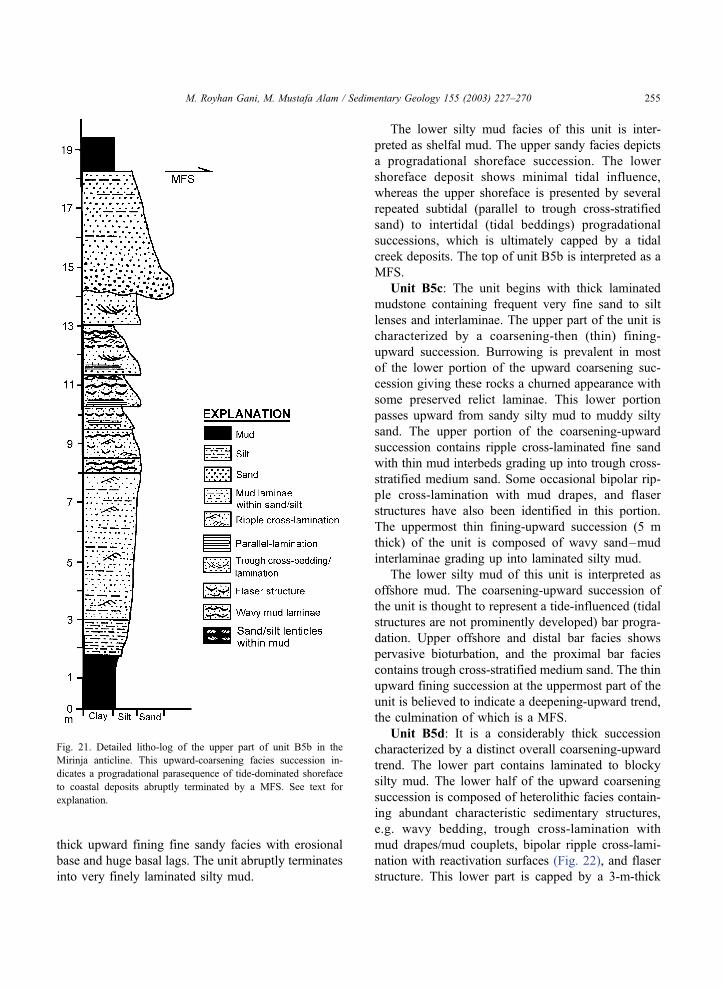
thick upward fining fine sandy facies with erosional
base and huge basal lags. The unit abruptly terminates
into very finely laminated silty mud.
The lower silty mud facies of this unit is inter-
preted as shelfal mud. The upper sandy facies depicts
a progradational shoreface succession. The lower
shoreface deposit shows minimal tidal influence,
whereas the upper shoreface is presented by several
repeated subtidal (parallel to trough cross-stratified
sand) to intertidal (tidal beddings) progradational
successions, which is ultimately capped by a tidal
creek deposits. The top of unit B5b is interpreted as a
MFS.
Unit B5c: The unit begins with thick laminated
mudstone containing frequent very fine sand to silt
lenses and interlaminae. The upper part of the unit is
characterized by a coarsening-then (thin) fining-
upward succession. Burrowing is prevalent in most
of the lower portion of the upward coarsening suc-
cession giving these rocks a churned appearance with
some preserved relict laminae. This lower portion
passes upward from sandy silty mud to muddy silty
sand. The upper portion of the coarsening-upward
succession contains ripple cross-laminated fine sand
with thin mud interbeds grading up into trough cross-
stratified medium sand. Some occasional bipolar rip-
ple cross-lamination with mud drapes, and flaser
structures have also been identified in this portion.
The uppermost thin fining-upward succession (5 m
thick) of the unit is composed of wavy sand–mud
interlaminae grading up into laminated silty mud.
The lower silty mud of this unit is interpreted as
offshore mud. The coarsening-upward succession of
the unit is thought to represent a tide-influenced (tidal
structures are not prominently developed) bar progra-
dation. Upper offshore and distal bar facies shows
pervasive bioturbation, and the proximal bar facies
contains trough cross-stratified medium sand. The thin
upward fining succession at the uppermost part of the
unit is believed to indicate a deepening-upward trend,
the culmination of which is a MFS.
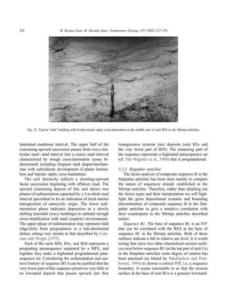
Unit B5d: It is a considerably thick succession
characterized by a distinct overall coarsening-upward
trend. The lower part contains laminated to blocky
silty mud. The lower half of the upward coarsening
succession is composed of heterolithic facies contain-
ing abundant characteristic sedimentary structures,
e.g. wavy bedding, trough cross-lamination with
mud drapes/mud couplets, bipolar ripple cross-lami-
nation with reactivation surfaces (Fig. 22), and flaser
structure. This lower part is capped by a 3-m-thick
Fig. 21. Detailed litho-log of the upper part of unit B5b in the
Mirinja anticline. This upward-coarsening facies succession in-
dicates a progradational parasequence of tide-dominated shoreface
to coastal deposits abruptly terminated by a MFS. See text for
explanation.
M. Royhan Gani, M. Mustafa Alam / Sedimentary Geology 155 (2003) 227–270 255
laminated mudstone interval. The upper half of the
coarsening-upward succession passes from wavy-len-
ticular sand–mud interval into a coarse sand interval
characterized by trough cross-lamination (some bi-
directional) including frequent mud drapes/interlam-
inae with subordinate development of planar lamina-
tion and bipolar ripple cross-lamination.
The unit distinctly reflects a shoaling-upward
facies succession beginning with offshore mud. The
upward coarsening deposit of this unit shows two
phases of sedimentation separated by a 3-m-thick mud
interval speculated to be an indication of local marine
transgression of autocyclic origin. The lower sedi-
mentation phase indicates deposition in a slowly
shifting intertidal (wavy beddings) to subtidal (trough
cross-stratification with mud couplets) environments.
The upper phase of sedimentation may represent tidal
ridge/delta front progradation in a tide-dominated
deltaic setting very similar to that described by Cole-
man and Wright (1975).
Each of the units B5b, B5c, and B5d represents a
prograding parasequence separated by a MFS, and
together they make a highstand progradational para-
sequence set. Considering the sedimentation and sea-
level history of sequence B5 it can be justified that the
very lower part of this sequence preserves very little or
no lowstand deposit that passes upward into thin
transgressive systems tract deposits (unit B5a and
the very lower part of B5b). The remaining part of
the sequence represents a highstand parasequence set
(cf. Van Wagoner et al., 1988) that is progradational.
3.2.2. Sitapahar anticline
The facies analysis of composite sequence B in the
Sitapahar anticline has been done mainly to compare
the nature of sequences already established in the
Mirinja anticline. Therefore, rather than detailing out
the facies types and their interpretation we will high-
light the gross depositional scenario and bounding
discontinuities of composite sequence B in the Sita-
pahar anticline to give a tentative correlation with
their counterparts in the Mirinja anticline described
earlier.
Sequence B1. The base of sequence B1 is an IVF
that can be correlated with the RES at the base of
sequence B1 in the Mirinja anticline. Both of these
surfaces indicate a fall in relative sea level. It is worth
noting that since two other channelized erosion surfa-
ces exist below sequence B1 (at the top part of unit Ce)
in the Sitapahar anticline some degree of caution has
been practised (as hinted by MacEachern and Pem-
berton, 1994) to choose a correct IVF, i.e. a sequence
boundary. It seems reasonable to us that the erosion
surface at the base of unit B1a is a genuine lowstand-
Fig. 22. Typical ‘tidal’ bedding with bi-directional ripple cross-lamination at the middle part of unit B5d in the Mirinja anticline.
M. Royhan Gani, M. Mustafa Alam / Sedimentary Geology 155 (2003) 227–270256
induced surface to be considered as sequence boun-
dary. Unit B1a is interpreted as inner estuary fluvial
channel-fill facies which begins with a distinct 5-m-
thick conglomerate bed passing upward into a very
thick, fine to medium, structureless sand interval with
occasional thin mudstone interlaminae. The top part of
the channel-fill reflects a rapid deepening, indicated by
the appearance of thicker laminated mud intervals
within sandstone, culminating at the top by TS. The
lower part of unit B1a is thought to represent lowstand
systems tract and the rest is transgressive systems tract.
However, no distinct boundary has been identified
between these two systems tracts.
The remaining part of sequence B1 is a highstand
systems tract consisting of two parasequences that are
represented by units B1b and B1c. Unit B1b is
thought to represent a tide-influenced shoreline pro-
gradation on shelf mudstone. Two hummocky cross-
stratified sandstone beds 30 cm thick have been
encountered within the offshore mud. Progradational
shoreline facies at the upper part of the unit are
characterized by sandier upward trends in which sand
bar/dune cross-bedded facies is absent. Bipolar ripple
cross-lamination with flaser bedding indicates tide
influence. The top of unit B1b is regarded as a MFS
because the unit is abruptly overlain by shelfal mud-
stone of the next parasequence. Unit B1c is again a
progradational shoreline parasequence that is also
interestingly devoid of any cross-bedded facies.
Wavy-lenticular sand–mud facies, typical upward
fining (15–50-cm-thick) tidal flat facies, massive
channel (?) sand facies, are rather randomly associated
(like in unit B1b of the Mirinja anticline) under slowly
shifting coastline. It should noted that the speculated
RES at the lower part of unit B1b in the Mirinja
anticline is not represented in the Sitapahar anticline.
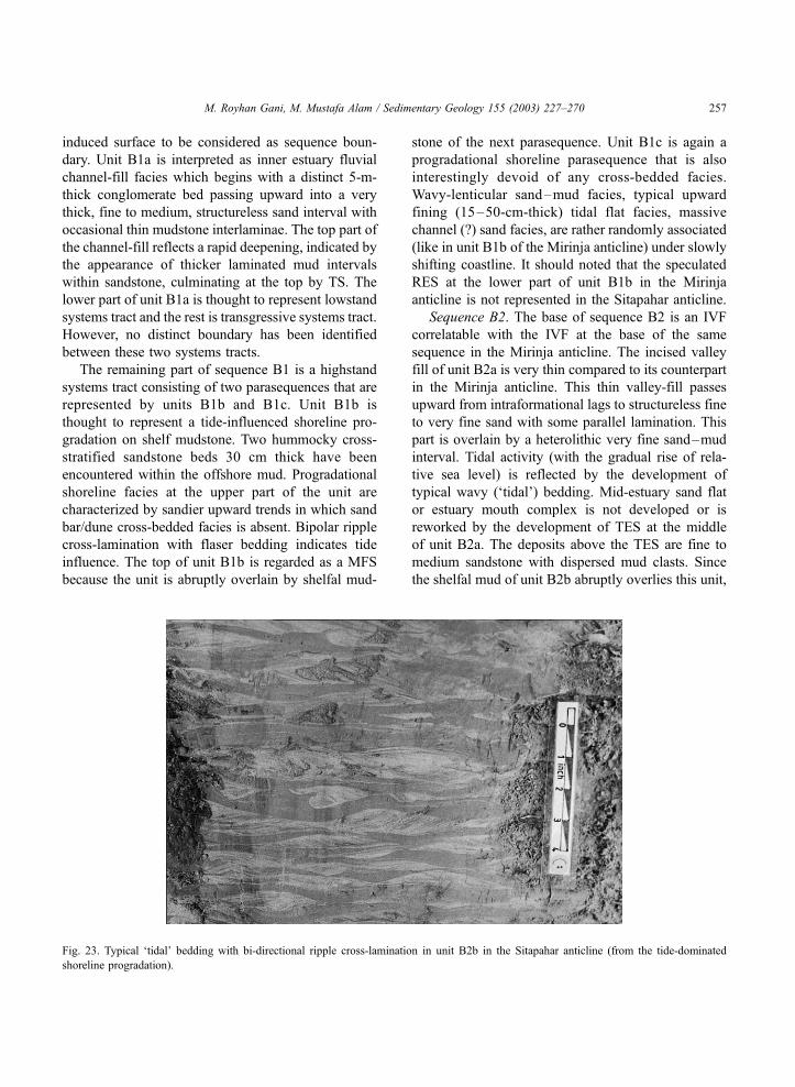
Sequence B2. The base of sequence B2 is an IVF
correlatable with the IVF at the base of the same
sequence in the Mirinja anticline. The incised valley
fill of unit B2a is very thin compared to its counterpart
in the Mirinja anticline. This thin valley-fill passes
upward from intraformational lags to structureless fine
to very fine sand with some parallel lamination. This
part is overlain by a heterolithic very fine sand–mud
interval. Tidal activity (with the gradual rise of rela-
tive sea level) is reflected by the development of
typical wavy (‘tidal’) bedding. Mid-estuary sand flat
or estuary mouth complex is not developed or is
reworked by the development of TES at the middle
of unit B2a. The deposits above the TES are fine to
medium sandstone with dispersed mud clasts. Since
the shelfal mud of unit B2b abruptly overlies this unit,
Fig. 23. Typical ‘tidal’ bedding with bi-directional ripple cross-lamination in unit B2b in the Sitapahar anticline (from the tide-dominated
shoreline progradation).
M. Royhan Gani, M. Mustafa Alam / Sedimentary Geology 155 (2003) 227–270 257

the top of unit B2a is interpreted as a maximum MFS.
Above the shelfal mud of B2b the remaining part of
the unit is a sandier upward succession interpreted as
tide-dominated shoreline progradation (Fig. 23) devel-
oped at the time of highstand condition. It is important
to note that the upper part of sequence B2, sequence
B3, and the lower part of sequence B4 are missing
because of the stratigraphic break at the Manikchari
fault (Fig. 4B).
Sequence B4. Above the fault only the upper part
of sequence B4 is observed that reflects a sandier
upward trend. Rizocorallium and Zoophycos trace-
makers are present in the offshore mudstone. The
sedimentary structures in the lower shoreline muddy
sandstone are obliterated by extensive burrowing that
renders this rock a churned appearance.
Sequence B5. The lower boundary of this sequence
is an IVF similar to that in the Mirinja anticline. The
lower part of unit B5a is interpreted as an incised
fluvial channel deposits containing 4-m-thick basal
lags of mud clasts (up to 60 cm long), sand pebbles
and quartz pebbles. The valley-fill distinctly fines
upward from coarse sandstone to very fine sandstone
with large- to small-scale trough cross-stratification.
Bidirectional trough cross-bedding at the top part of
this fill records evidence for tidal activity resulting
from the initial phase of sea-level rise, and gradually
passes upward into 10-m-thick silty mudstone. This
succession is erosionally truncated by another small
(10 m thick) channel speculated to be an inner estuary
tidal meander although no sedimentary structure
except some parallel lamination is observed within
the medium sandstone of the channel-fill. The top of
unit B5a is interpreted as TS. The rest of sequence B5
is a highstand systems tract consisting of three para-
sequences—units B5b, B5c, and B5d. Units B5b and
B5c are very thin and characteristically sharp-based
on offshore mudstone indicating that high-frequency
relative sea-level falls during the overall rise. There-
fore, the parasequence designation of these two units
may not be appropriate in a strict sense. The upper-
most unit B5d is a distinct shoaling/coarsening-
upward tide-dominated shoreline progradation. The
offshore facies characteristically consists of a thick
interval of interlaminated siltstone and mudstone with
delicate parallel-, wavy-, to ripple-lamination. Shore-
face facies shows several meter-thick upward coars-
ening successions each containing laminated mud
grading up into bipolar ripple cross-laminated fine
sand. These successions are thought to represent the
progradation of several small-scale bars. The topmost
part of unit B5d develops a typical wavy-lenticular
tidal bedding of intertidal deposits. The top of
sequence B5 is a pronounced erosion surface indicat-
ing a large fall of relative sea level.
3.3. Composite sequence A
This upper composite sequence of the Neogene
clastic succession in the CTFB represents the final
stage of progradational basin-fill history. The entire
sequence, essentially fluvial deposits, is exclusively
sandstone dominated with a characteristic yellowish-
brown colour. A detailed account of the lithofacies
types with their depositional connotation was given
by Alam (1996) and Alam and Ferdous (1995). Only a
brief description of the composite sequence A, which
shows similar patterns in both the anticlines, is pre-
sented below.
The sequence begins on a pronounced erosion
surface interpreted as an IVF overlain by a 2–5-m-
thick characteristic conglomerate bed consisting of
mud clasts (up to 15 cm long) with some quartz
pebbles (Fig. 24). The lowermost 40–50 m of the
composite sequence indicates an upward fining single
channel cycle that quickly evolves into an estuary
channel within a few meters up-sequence because of
the rise of relative sea level. The lower portion of this
cycle contains parallel to bidirectional cross-bedded
medium sandstone with some mud-draped foresets.
In the upper part, sandstone is ripple cross-laminated
with thin wavy mud laminae, the frequency of which
increases upward. The channel-fill culminates with
meter-thick laminated mudstone. Mud drapes, fre-
quent wavy mud interlaminae, and bipolar current
directions within dunes and ripples indicate the
influence of tides in the upper part of the channel
deposits. Most of the remaining parts of the compo-
site sequence consist of monotonous medium sand-
stone characterized by trough cross-, planar cross-,
and parallel-bedding (Fig. 25) with some ripple
cross-lamination and mud interlaminae, thought to
represent various types of channel bar deposits of a
large-scale braided river system. One characteristic
50+-m-thick zone of laminated mudstone with some
laminae and lenses of very fine sand are encountered
M. Royhan Gani, M. Mustafa Alam / Sedimentary Geology 155 (2003) 227–270258
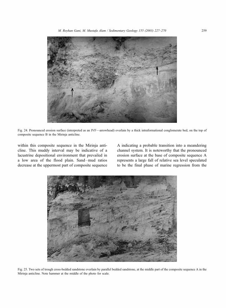
within this composite sequence in the Mirinja anti-
cline. This muddy interval may be indicative of a
lacustrine depositional environment that prevailed in
a low area of the flood plain. Sand–mud ratios
decrease at the uppermost part of composite sequence
A indicating a probable transition into a meandering
channel system. It is noteworthy that the pronounced
erosion surface at the base of composite sequence A
represents a large fall of relative sea level speculated
to be the final phase of marine regression from the
Fig. 25. Two sets of trough cross-bedded sandstone overlain by parallel bedded sandstone, at the middle part of the composite sequence A in the
Mirinja anticline. Note hammer at the middle of the photo for scale.
Fig. 24. Pronounced erosion surface (interpreted as an IVF—arrowhead) overlain by a thick intraformational conglomerate bed, on the top of
composite sequence B in the Mirinja anticline.
M. Royhan Gani, M. Mustafa Alam / Sedimentary Geology 155 (2003) 227–270 259

entire CTFB most probably associated with a tectonic
upheaval.
4. Discussion
4.1. Depositional and basin-fill history in relation to
sequence stratigraphy
The study presents a conventional facies analysis
that is set forth in a high-resolution sequence strati-
graphic framework to give a comprehensive scenario
of the stratigraphic architecture and depositional pro-
cesses of the Neogene clastic succession in the CTFB.
The entire lithostratigraphic column presented in Fig.
4 has been divided in a hierarchical order into com-
posite sequences, sequences, systems tracts, and para-
sequences on the basis of the key bounding
discontinuities of sequence stratigraphy. The nearly
complete documentation of the exposed rock succes-
sion with its interpreted facies and bounding disconti-
nuities, and its tentative regional correlation provide a
detailed understanding of the progressive basin-fill
history of southeastern Bengal Basin.
The identified bounding discontinuities can be
grouped broadly into two categories—those related
to marine regression associated with relative sea-level
fall and those related to marine transgression and
relative sea-level rise. In this study, incised valley
floor (IVF) and regressive erosion surface (RES) are
the surfaces generated by a fall in relative sea level
and form the sequence boundary. IVF is a prominently
developed surface forming a type I sequence boun-
dary according to the Exxon model (cf. Van Wagoner
et al., 1988). The RES was generated subaqueously by
either tidal scouring (e.g. below sequence B1 in the
Mirinja anticline) or wave scouring (e.g. below unit
Cb in the Mirinja anticline) associated with forced
regression. There has been considerable debate about
the origin and systems tract designation of sandbodies
resting on this type of erosion surface (e.g. Hunt and
Tucker, 1995; Kolla et al., 1995). For a recent dis-
cussion on the topic see MacEachern et al. (1999). In
general, when sea-level falls the landward develop-
ment of an initial subaerial exposure surface and/or an
incised valley floor passes seaward into a correlative
marine erosion surface (i.e. RES) and correlative
conformity surface. The architecture of the generated
sandbodies (above the RES) varies in the different
settings and combinations depending on the rate and
magnitude of the relative sea-level fall. With a limited
landward and seaward database, such as the present
study, it is better to assign these sandbodies generated
on a RES to a more general term like lowstand
systems tract. It is notable that a nonerosional regres-
sive surface (i.e. sharp but not erosional contact
associated with sharp-based sandbody) was described
in sequence B5 of the Sitapahar anticline.
Transgressive erosion surface (TES) and transgres-
sive surface/marine flooding surface (TS/MFS) within
the studied succession are related to a rise in relative
sea level. TES was formed subaqueously by either
wave scouring (wave ravinement surface, most com-
mon in the present study) or tidal scouring (tidal
ravinement surface). TESs are overlain either by thin
sandbodies with dispersed mud clasts (upper part of
unit B2a in both the anticlines) (Fig. 15) or by a few
centimeters thick mud and sand pebbles (top of units
B3a and B4a in the Mirinja anticline) (Fig. 17) and
pass upward into shelfal mudstone. TS and MFS are
both nonerosion surfaces across which there is evi-
dence of abrupt increase in water depth. The term
MFS is used in the case where this apparent deep-
ening caps a prograding parasequence (cf. Van Wag-
oner et al., 1988); in other cases, the term TS is used.
It is acknowledged that generation of MFSs could be
due to autocyclic processes (Walker, 1990; Miall,
1997).
In the present study, the Neogene clastic succession
of CTFB has been grouped into three composite
sequences—C, B and A, from oldest to youngest
(Fig. 4), that record a progressive basin-filling history
from deep marine to continental–fluvial environ-
ments. It is important to note that the correlation
between the two anticlines represents a depositional-
strike parallel correlation, and that the eastward and
westward current directions indicate landward and
basinward directions, respectively. The internal sed-
imentation patterns of composite sequence C shows
the least similarity (compared to the other two com-
posite sequences) between the two anticlines. The
deep marine base-of-slope deposits are encountered
only in the Sitapahar anticline (unit Ca). These depos-
its are interpreted as ‘mud/sand-rich slope apron’
according to the classification scheme of Reading
and Richards (1994). Small-scale depositional lobes,
M. Royhan Gani, M. Mustafa Alam / Sedimentary Geology 155 (2003) 227–270260

channel–levee systems, and slump–debris mass char-
acterize the slope apron deposits. For a detailed
account of these deep-sea clastics see Gani and Alam
(1999). The base-of-slope clastics gradually pass
upward into shallow marine sandbodies through a
thick zone of muddy slope and shelf deposits. The
first neritic sandbody in both anticlines (unit Cb in the
Mirinja anticline and the upper part of Cb in the
Sitapahar anticline) (Figs. 5 and 13) is dissimilar in
nature. The sandbody in the Mirinja anticline (unit
Cb) rests on a RES and characteristically evolves
upward from storm-dominated shelf deposits to tide-
dominated shelf deposits (this type of combination
within a single progradational sandbody is not com-
mon in the geological record). The lower part of this
sandbody develops several typical storm-generated
and thin-bedded fining-upward cycles (Fig. 5). The
sandbody in the Sitapahar anticline (upper part of unit
Cb) (Fig. 13) is gradationally based and is character-
ized by a distinct coarsening- and thickening-upward
trend of tidal sand ridge progradation on shelfal
mudstone (Fig. 13). The rest of the composite
sequence C in the Sitapahar anticline reflects the
development of several progradational parasequences
separated by MFSs. The equivalent succession in the
Mirinja anticline does not show any parasequence;
rather, two submarine channels encased within the
upper slope to shelfal mudstone characterize its devel-
opment. The lower channel is characterized by a
chaotic fill of rapid clogging, while the upper channel
is a mature one and depicted with thick-bedded
turbidites (Figs. 9 and 10). Both the channels are
interpreted as highstand deposits with sediment trans-
port into the deep basin even at high sea level. It
should be noted that the RES at the base of unit Cb in
the Mirinja anticline is not observed in the Sitapahar
anticline, and is interpreted as a local phenomenon
(possibly due to a high-frequency sea-level fall).
Therefore, this RES is not treated as a sequence
boundary. It is also worth noting that in composite
sequence C shale predominates over sandstone, sug-
gesting that during this period the basin had high
accommodation space.
A pronounced relative sea-level fall terminated
the deposition of composite sequence C and initiated
the development of composite sequence B and a new
basin-fill history. This composite sequence in both
anticlines shows similar pattern of paralic sedimen-
tation under repeated rise and fall of relative sea
level. The base of composite sequence B is repre-
sented by an IVF in the Sitapahar anticline and a
pronounced RES in the Mirinja anticline. Sequence
B1 in the Sitapahar anticline begins with a character-
istic very thick and structureless fill of an incised
valley. This sequence gives a record of all the three
systems tracts of a typical sequence. The lower part
(unit B1a) is thought to be a lowstand deposit that is
overlain by the development of a thin transgressive
systems tract. The rest of the sequence is a highstand
systems tract that includes one parasequence of tidal
bar progradation in the Mirinja anticline, whereas it
includes two parasequences of tide-influenced shore-
line progradation in the Sitapahar anticline. The base
of this sequence in the Mirinja anticline is a RES,
which is thought to have been generated by tidal
current scouring—a rare case in geological literature.
Another similar RES (within unit B1b in the Mirinja
anticline) is not present in the Sitapahar anticline
indicating that this erosion surface may be autocyclic
in origin and probably represents a bedload parting
zone (Harris et al., 1995). Thereupon this RES is not
considered a sequence boundary. It is apparent that
sequence B3 is missing in the Sitapahar anticline
because of the Manikchari fault. Sequences B2, B3,
and B4 in the Mirinja anticline represent repetitive
development of incised valley complexes. It is sur-
prising to note that the highstand systems tracts
within these sequences include only shelfal mud-
stone. It can be argued that either the highstand
parasequences are eroded away beneath the incised
valleys, or the landward shifted shoreline facies
because of marine transgression did not get time to
prograde to the study area (i.e. the intervening still-
stand periods were very short). However, the surviv-
ing thin parasequence (of sequence B4) below the
IVF of sequence B5 in the Sitapahar anticline sup-
ports the former contention. The youngest sequence
B5 of composite sequence B reflects the develop-
ment of all three systems tracts of a typical sequence.
The lowstand systems tract is represented by fluvial-
incised valley-fill at the very lower part of the
sequence; the overlying transgressive systems tract
is likewise thinly developed. The highstand systems
tract, on the other hand, is distinctly developed with
three progradational parasequences separated by
MFSs.
M. Royhan Gani, M. Mustafa Alam / Sedimentary Geology 155 (2003) 227–270 261
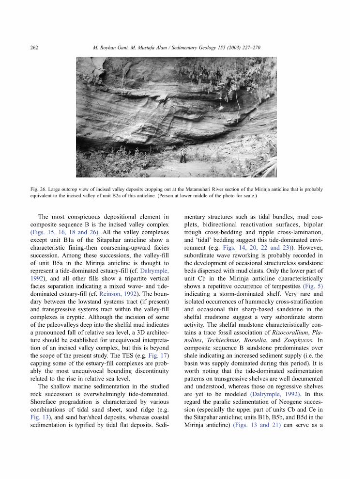
The most conspicuous depositional element in
composite sequence B is the incised valley complex
(Figs. 15, 16, 18 and 26). All the valley complexes
except unit B1a of the Sitapahar anticline show a
characteristic fining-then coarsening-upward facies
succession. Among these successions, the valley-fill
of unit B5a in the Mirinja anticline is thought to
represent a tide-dominated estuary-fill (cf. Dalrymple,
1992), and all other fills show a tripartite vertical
facies separation indicating a mixed wave- and tide-
dominated estuary-fill (cf. Reinson, 1992). The boun-
dary between the lowstand systems tract (if present)
and transgressive systems tract within the valley-fill
complexes is cryptic. Although the incision of some
of the paleovalleys deep into the shelfal mud indicates
a pronounced fall of relative sea level, a 3D architec-
ture should be established for unequivocal interpreta-
tion of an incised valley complex, but this is beyond
the scope of the present study. The TES (e.g. Fig. 17)
capping some of the estuary-fill complexes are prob-
ably the most unequivocal bounding discontinuity
related to the rise in relative sea level.
The shallow marine sedimentation in the studied
rock succession is overwhelmingly tide-dominated.
Shoreface progradation is characterized by various
combinations of tidal sand sheet, sand ridge (e.g.
Fig. 13), and sand bar/shoal deposits, whereas coastal
sedimentation is typified by tidal flat deposits. Sedi-
mentary structures such as tidal bundles, mud cou-
plets, bidirectional reactivation surfaces, bipolar
trough cross-bedding and ripple cross-lamination,
and ‘tidal’ bedding suggest this tide-dominated envi-
ronment (e.g. Figs. 14, 20, 22 and 23)). However,
subordinate wave reworking is probably recorded in
the development of occasional structureless sandstone
beds dispersed with mud clasts. Only the lower part of
unit Cb in the Mirinja anticline characteristically
shows a repetitive occurrence of tempestites (Fig. 5)
indicating a storm-dominated shelf. Very rare and
isolated occurrences of hummocky cross-stratification
and occasional thin sharp-based sandstone in the
shelfal mudstone suggest a very subordinate storm
activity. The shelfal mudstone characteristically con-
tains a trace fossil association of Rizocorallium, Pla-
nolites, Techiechnus, Rosselia, and Zoophycos. In
composite sequence B sandstone predominates over
shale indicating an increased sediment supply (i.e. the
basin was supply dominated during this period). It is
worth noting that the tide-dominated sedimentation
patterns on transgressive shelves are well documented
and understood, whereas those on regressive shelves
are yet to be modeled (Dalrymple, 1992). In this
regard the paralic sedimentation of Neogene succes-
sion (especially the upper part of units Cb and Ce in
the Sitapahar anticline; units B1b, B5b, and B5d in the
Mirinja anticline) (Figs. 13 and 21) can serve as a
Fig. 26. Large outcrop view of incised valley deposits cropping out at the Matamuhari River section of the Mirinja anticline that is probably
equivalent to the incised valley of unit B2a of this anticline. (Person at lower middle of the photo for scale.)
M. Royhan Gani, M. Mustafa Alam / Sedimentary Geology 155 (2003) 227–270262

good point of reference for the tide-dominated regres-
sive shelf depositional systems.
Again a pronounced fall in relative sea level
terminated the sequential development of paralic sed-
imentation in composite sequence B and brought forth
the continental–fluvial sedimentation of composite
sequence A, which represents the final phase of a
progressive basin-fill history. A 2–5-m-thick con-
glomerate bed at the base of composite sequence A
is present in both anticlines (Fig. 24). The very lower
part of this composite sequence represents a coastal
braid plain environment that passes upward into a
monotonous stacking of various sand bars of a braided
river system. The upper part of the composite
sequence reflects a gradual transition to a meandering
river system with a low sand–mud ratio.
The analytical approach presented here to interpret
the rock succession is a kind of high-resolution
sequence stratigraphy that is increasingly used as an
effective tool in hydrocarbon reservoir delineation
(e.g. Posamentier and Chamberlin, 1993). The explo-
ration strategies so far taken over the eastern Bengal
Basin give importance only to the structural traps
(fault-bounded anticlines). The facies and facies
sequence analysis of the present study sheds light
on a new type of play concept. The bounding dis-
continuities identified within the rock succession can
help both in the exploration and exploitation strat-
egies by elucidating the location and geometry of
stratigraphic traps, outlining seal architecture, and
delineating flow units. For example, some of the
incised valley fills, abruptly bounded both below
and above by highstand and transgressive marine
mudstones, respectively, act as good stratigraphic
traps. Several MFS-bounded parasequences are
abruptly overlain by transgressive shelfal muds,
which can act as seals as well as good source rocks.
The present research also hints toward another pro-
spective and new type of hydrocarbon play (i.e. the
deep-sea clastic play), which demands proper evalua-
tion. The hemipelagic mudstone encountered in unit
Ca in the Sitapahar anticline is highly carbonaceous.
The organic matter entrapped in deep-marine shale is
generally believed to be oil-prone. The submarine
channels of units Cc and Ce in the Mirinja anticline,
and the turbidite packets encased within the basinal
mudstone of unit Ca in the Sitapahar anticline can
serve as good examples of stratigraphic traps.
4.2. Palaeogeographic reconstruction in relation to
tectonic setting
One of the serious misconceptions about the basin
evolution has arisen from the fact that the entire
Bengal Basin has been indiscriminately designated
as a ‘foreland basin’. It is important to realize that the
present-day Bengal Basin occupies at least three
different tectonic provinces (Fig. 27)—(i) passive to
extensional cratonic margin in the west, (ii) collision-
related orogeny in the northeast, and (iii) subduction-
related orogeny in the east (CTFB region). These
tectonic provinces have given rise to much complexity
in the evolution of the Bengal Basin (for an overview
see Alam et al., 2003). Gani and Alam (1999) have
presented a somewhat refined tectonic evolution for
the eastern Bengal Basin, and suggested a subduction-
related (oblique subduction) active margin setting for
the CTFB, which is probably related more to the
evolutionary history of the western margin of the
Burmese plate than to the eastern margin of the Indian
plate.
Since the present study deals with the Neogene
rock succession of the CTFB, and the sedimentation
and tectonics are very much interrelated, it is impor-
tant to understand the early Neogene palaeogeography
of this part of the basin. During the very Early
Miocene the paleogeographic setting of the CTFB
included the westward migrating trench-slope bathy-
metry, and the sediment source was largely from the
newly uplifted Indoburman subduction complex to the
east (Figs. 3 and 27). The schematic palaeogeographic
(Early Miocene) map of the Bengal Basin and its
surroundings (Fig. 27) indicates that the tectonic
setting of the CTFB was different from other parts
of the basin. The remnant ocean basin had been
closing from northeast to southwest because of obli-
que subduction. As a result, the trench-slope bathy-
metry of the subduction zone had also been smoothing
out toward the south. It is notable that the slope apron
deposit at the lowest part of the studied rock succes-
sion was developed on a late-stage trench-slope
bathymetry (Gani and Alam, 1999), and that the
deep-water embayment (Fig. 27) has been smoothed
to shallow water conditions probably sometime in the
Late Miocene. The block diagram (Fig. 28) represents
the gross sedimentation pattern in the CTFB during
the Early Miocene.
M. Royhan Gani, M. Mustafa Alam / Sedimentary Geology 155 (2003) 227–270 263

The basic sequence model of Exxon was originally
developed in a passive to extensional plate margin
setting, and should be used with caution in case of
active margin setting (e.g. Miall, 1997) similar to the
CTFB overlying the zone of convergence. In an active
margin setting several distinct processes, of which
tectonic basin subsidence and source-area uplift are
most important, lead to local and regional changes in
relative sea level and thereby control the architecture
of the basin fill (e.g. Fulford and Busby, 1993). Large
Fig. 28. Conceptual Early Miocene paleogeographic model showing the sedimentation pattern (at highstand condition) within the active margin
setting of the Indo-Burmese oblique plate convergence (province 3 of Fig. 27).
Fig. 27. Schematic paleogeographic (Early Miocene) representation of the Bengal Basin and surroundings incorporating the plate tectonic
model. The positions of the three tectonic provinces of the Bengal Basin are shown by encircled numbers: (1) western Bengal Basin, (2)
northeastern Bengal Basin, and (3) eastern Bengal Basin (CTFB).
M. Royhan Gani, M. Mustafa Alam / Sedimentary Geology 155 (2003) 227–270264

differences in the thickness and facies of the same
sequence (within composite sequences C and B) in the
two anticlines that are aligned along the strike are
believed to be due to these processes within the active
margin setting. The nature of sea-level change (e.g.
either eustatic or relative), which has given rise to
several regional bounding discontinuities in the
studied rock succession, and also the chronological
nature of these discontinuities (i.e. either synchronous
or diachronous) remain unsolved, and will require
further research. It is to be noted that the coupled
regressive/transgressive cycles of sequences B2, B3
and B4 in the Mirinja anticline are similar to the
coupled uplift-collapse cycles over relatively short
periods within the subduction zone described by Flint
et al. (1991).
4.3. Revision of traditional stratigraphic classification
In Section 2, the status of the traditional strati-
graphic nomenclature, which is based on the work of
Evans (1932) in the lower Assam Basin, has been
presented briefly. Traditionally, without any detailed
regional correlation, the lithostratigraphic scheme of
Evans (1932) has been casually extended for the entire
Bengal Basin mainly on the basis of loosely defined
lithologic similarity of the rock types. The danger of
this kind of regional simplification has been pointed
out by Das Gupta (1977) who regarded the Evans’
(1932) classification as merely local stratigraphy.
Brunnschweiler (1980) and Reimann (1993) strongly
argued the uncritical use of oversimplified conven-
tional stratigraphy. However, as no alternatives were
suggested the indiscriminate use of this traditional
stratigraphic terminology in various recent published
and unpublished works is still creating confusion and
dispute among regional geologists. In the previous
section, it was stated that the Bengal Basin includes at
least three discrete tectonic provinces, each with its
own tectonic and sedimentary history. Therefore,
separate stratigraphic classification scheme should
be established for each of the three tectonic provinces;
and only then intrabasinal (i.e. within these three
provinces) and interbasinal (e.g. between Bengal
Basin and Assam Basin) correlation of the strati-
graphic succession should be attempted.
In this section, a new tentative stratigraphic scheme
for the CTFB region is proposed. However, without
any regional marker bed or precise biostratigraphic
zonation it is difficult to undertake such an approach.
In fact, paleontologic dating is very difficult because
of high rates of sedimentation, the young age of the
rock succession, and the marginal marine nature of
many of the sediments (Harms, pers. comm., 2000).
We have adopted a sequence stratigraphic framework
giving emphasis to bounding discontinuities in order
to correlate the sediments and document the basin-fill
history of the Neogene clastic succession. However,
with the present database it is probably unwise to
propose a regional sequence stratigraphic nomencla-
ture for classification purposes, because, for example,
the bounding discontinuities are not yet clearly
Table 2
Revised allostratigraphic scheme for the Chittagong–Tripura Fold Belt (CTFB)
Age (approx.) Allogroup Thickness (approx.) (m) Brief description
Recent Alluvium
Plio–Pleistocene Kaptai 1100–1600 Large-scale, low-sinuosity braided river deposits grading
upward into high-sinuosity meandering river deposits.
Very high sand–shale ratio. Characteristically
yellowish-brown very coarse to fine sand.
Late Miocene Mirinja 1200–1600 Alternating nearshore sand and shelfal mud with regional
erosion surfaces related to relative sea level cycles.
High sand–shale ratio. Predominance of tidal
structures is obvious.
Middle Miocene Sitapahar 1000–1500 Slope mud predominant; sandy deposits ranging from
base-of-slope turbidites to nearshore tidal sands.
No major erosion surface.
Oligo–Early Miocene Chittagong 2000 + Speculated submarine fan complex in trench setting;
mud dominated.
M. Royhan Gani, M. Mustafa Alam / Sedimentary Geology 155 (2003) 227–270 265
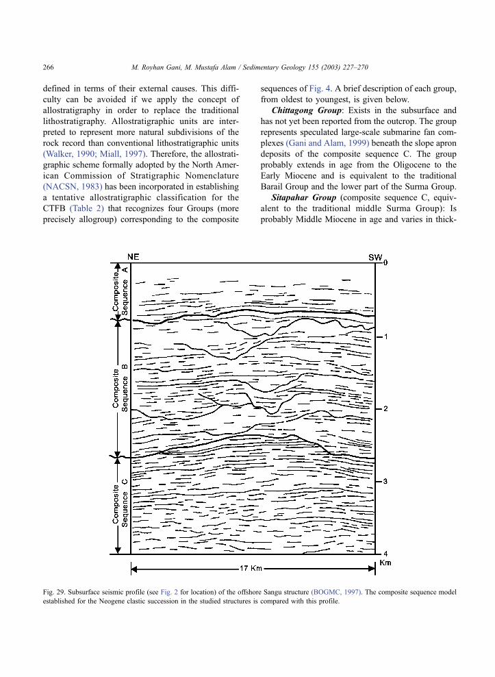
defined in terms of their external causes. This diffi-
culty can be avoided if we apply the concept of
allostratigraphy in order to replace the traditional
lithostratigraphy. Allostratigraphic units are inter-
preted to represent more natural subdivisions of the
rock record than conventional lithostratigraphic units
(Walker, 1990; Miall, 1997). Therefore, the allostrati-
graphic scheme formally adopted by the North Amer-
ican Commission of Stratigraphic Nomenclature
(NACSN, 1983) has been incorporated in establishing
a tentative allostratigraphic classification for the
CTFB (Table 2) that recognizes four Groups (more
precisely allogroup) corresponding to the composite
sequences of Fig. 4. A brief description of each group,
from oldest to youngest, is given below.
Chittagong Group: Exists in the subsurface and
has not yet been reported from the outcrop. The group
represents speculated large-scale submarine fan com-
plexes (Gani and Alam, 1999) beneath the slope apron
deposits of the composite sequence C. The group
probably extends in age from the Oligocene to the
Early Miocene and is equivalent to the traditional
Barail Group and the lower part of the Surma Group.
Sitapahar Group (composite sequence C, equiv-
alent to the traditional middle Surma Group): Is
probably Middle Miocene in age and varies in thick-
Fig. 29. Subsurface seismic profile (see Fig. 2 for location) of the offshore Sangu structure (BOGMC, 1997). The composite sequence model
established for the Neogene clastic succession in the studied structures is compared with this profile.
M. Royhan Gani, M. Mustafa Alam / Sedimentary Geology 155 (2003) 227–270266
ness from 1000 to 1500 m. The Rangamati–Chitta-
gong road section of the Sitapahar anticline is sug-
gested informally as the type section for this group.
The type section contains the oldest 1128+ m of the
rock succession (composite sequence C) exposed in
the eastern flank of the anticline. This group repre-
sents a progressive basin filling from deep marine
slope apron to shallow marine near shore deposits. No
major lowstand erosion surface has been recognized
in this group, where a low sandstone–shale ratio
indicates that the basin was accommodation domi-
nated during this time. The Sitapahar Group can be
farther divided into several alloformations based on
the bounding discontinuities (mainly the MFSs).
Mirinja Group (composite sequence B, equivalent
to the traditional upper Surma Group): Is probably
Late Miocene in age and varies in thickness from
1200 to 1600 m. The Lama–Fashiakhali road section
of the Mirinja anticline is suggested informally as the
type section for this group. In the type section, the
group is represented by the 1293 m of thick shelfal to
coastal succession (composite sequence B) exposed in
the western flank of the anticline. This group can
conveniently be divided into several alloformations
corresponding to the individual sequences, which in
turn can be divided further into allomembers based on
the TES and TS/MFS. The high sand–shale ratio of
this group indicates that the basin was supply domi-
nated during this period.
Kaptai Group (composite sequence A, equivalent
to the traditional Tipam Group and Dupitila Forma-
tion): Is probably Plio–Pleistocene in age and varies
in thickness from 1100 to 1600 m. The Kaptai–
Chandraghona road section in the western flank of
the Sitapahar anticline is suggested informally as the
type section for this group. The lower part of the
group represents braid plain coastal to fluvial deposits,
whereas the uppermost part represents deposits of a
meandering river system. The development of a 100–
200-m-thick patchy clay deposit (traditionally known
as the Girujan Clay) divides the group into the above-
mentioned two parts. Further study is needed to justify
such a subdivision.
The subsurface seismic profile of the offshore
Sangu structure (BOGMC, 1997) (Fig. 29) is used
to show the justification of the above-described strati-
graphic classification in a regional context. Except for
the lowermost group in our proposed stratigraphic
scheme (Table 2) the other three groups, i.e. the
composite sequences C, B and A, are clearly identi-
fied in this seismic profile. Composite sequence C
indicates a rather stable depositional scenario without
the development of any major erosion surface. Com-
posite sequence B shows several distinct erosion
surfaces most of which are interpreted as incised
valleys developed at the time of lowstand conditions.
Coastal plain to delta top fluvial channel deposits are
represented by the uppermost composite sequence A,
which is experiencing transgression because of the
Holocene sea-level rise. In the seismic profile, which
lies basinward from the study area (see Fig. 2 for
location), composite sequences C and B are thicker
and composite sequence A is thinner than their
equivalent composite sequences in the studied anti-
clines. However, it is suggested that further rigorous
studies, both from surface and subsurface, including
biostratigraphic age dating, are needed to formalize
the given stratigraphic scheme and to standardize the
interpreted sequences.
5. Conclusions
(1) The Neogene clastic succession (3000+ m
thick) as exposed in the CTFB represents an overall
basinward progradation from deep marine through
shallow marine to continental–fluvial environments
deposited within the subduction-related (oblique sub-
duction) active margin setting of the Indo-Burmese
plate convergence.
(2) A high-resolution sequence stratigraphic frame-
work has been adopted to interpret the basin-fill
history in response to relative sea-level changes, and
to subdivide the rock record into several sequences
and units (systems tracts and parasequences) based on
the identified bounding discontinuities, including
transgressive erosion surface (TES), regressive ero-
sion surface (RES), transgressive surface (TS), marine
flooding surface (MFS), and incised valley floor
(IVF).
(3) The entire succession can be broadly divided
into three composite sequences—C, B and A, from
oldest to youngest, on the basis of two regionally
correlatable pronounced lowstand erosion surfaces.
(4) In composite sequence C, slope apron deep-sea
clastics shoals upward into shallow marine and near-
M. Royhan Gani, M. Mustafa Alam / Sedimentary Geology 155 (2003) 227–270 267

shore clastics through a thick zone of slope mudstone.
Composite sequence B characteristically depicts tide-
dominated open-marine to coastal depositional sys-
tems with repetitive occurrences of incised valley,
tidal inlet, tidal ridge/shoal, and tidal flat deposits that
are separated by shelfal mudstone under the control of
cyclic fall and rise of relative sea level. At the final
phase of marine regression, composite sequence A
gradually establishes coastal plain through alluvial
plain fluvial depositional systems characterized by
stacked braided river sand bars that pass upsequence
into meandering river deposits.
(5) The bounding discontinuities identified within
the rock succession provide an insight into the explo-
ration and exploitation strategies for hydrocarbons
both in terms of location and geometry of stratigraphic
traps, outlining seal architecture and flow units.
(6) It is strongly recommended that the tradi-
tional lithostratigraphic classification practiced for
the CTFB be revised. A tentative stratigraphic
scheme incorporating the concept of allostratigraphy
is suggested. Further study including precise bio-
stratigraphic zonation is needed to formalize the
scheme.
Acknowledgements
The first author would like to thank D. Zafrul
Hassan for giving logistic support during the field-
work in the Mirinja anticline; and Abdul Hoque for
field assistance and Dr. Manzoor Hasan for logistic
support during the fieldwork in the Sitapahar
anticline. We thank Drs. Katherine Bergman, Tim
Cross and G. Shanmugam for their extensive reviews,
critical and constructive comments as well as many
thoughtful suggestions, which significantly improved
the paper.
References
Alam, M., 1989. Geology and depositional history of Cenozoic
sediments of the Bengal Basin of Bangladesh. Palaeogeogr.,
Palaeoclimatol., Palaeoecol. 69, 125–139.
Alam, M., 1997. Bangladesh. In: Moores, E.M., Fairbridge, R.W.
(Eds.), Encyclopedia of European and Asian Regional Geology.
Chapman & Hall, London, pp. 64–72.
Alam, M., Alam, M.M., Curray, J.R., Chowdhury, M.L.R., Gani,
M.R., 2003. An overview of the sedimentary geology of the
Bengal basin in relation to the regional tectonic framework
and basin-fill history. Sediment. Geol. (this volume).
Alam, M.K., Hasan, A.K.M.S., Khan, M.R., Whitney, J.W., 1990.
Geological map of Bangladesh. Geological Survey of Bangla-
desh, Dhaka, Scale 1:1,000,000.
Alam, M.M., 1995. Tide-dominated sedimentation in the Upper
Tertiary succession of the Sitapahar anticline, Bangladesh. In:
Flemming, B.W., Bortholoma, A. (Eds.), Tidal Signatures in
Modern and Ancient Sediments. Int. Assoc. Sedimentol., Spec.
Publ. 24, pp. 329–341.
Alam, M.M., 1996. Low-sinuosity braided-fluvial sedimentation
model: a comparison of the Lichubagan Sandstone Formation
and the Jamuna (Brahmaputra) River, Bangladesh. Indian J.
Earth Sci. 23, 13–19.
Alam, M.M., Ferdous, M.H.S., 1995. Lithofacies analysis and dep-
ositional environment of the Lichubagan Sandstone Formation
(Upper Tertiary) in the Sitapahar anticline, south-eastern Folded
Belt of Bangladesh. J. Indian Assoc. Sedimentol. 14, 9–18.
Alam, M.M., Ferdous, M.H.S., 1996. Neogene clastic succession of
the Sitapahar anticline southeastern Bangladesh: an example of
marine-continental transition. Dhaka Univ. J. Sci. 44 (1), 43–52.
Alam, M.M., Karim, S.M.R., 1997. Facies and environmental anal-
ysis of the Neogene (Surma Group) clastic succession in the
Mirinja anticline, Folded Belt of the Bengal Basin, Bangladesh.
Bangladesh Geosci. J. 3, 19–32.
Allen, J.R.L., 1982. Mud drapes in sandwave deposits: a physical
model with application to the Folkestone Beds (early Cretaceous
Southeast England). Philos. Trans. R. Soc. London, Ser. A 306,
291–345.
Allen, G.P., 1991. Sedimentary processes and facies in the Gironde
estuary: a model for macrotidal estuarine systems. In: Smith,
D.G., Reinson, G.E., Rahmani, B.A. (Eds.), Clastic Tidal Sed-
imentology. Can. Soc. Pet. Geol., Mem. 16, pp. 219–226.
Arnott, R.W.C., Hein, F.J., Pemberton, S.G., 1995. Influence of the
ancestral Sweetgrass Arch on sedimentation of the Lower Creta-
ceous Bootlegger Member, north-central Montana. J. Sediment.
Res. B65, 222–234.
Baksi, S.K., 1972. On the palynological biostratigraphy of the Ben-
gal Basin. In: Ghosh, A.K., et al. (Eds.), Proceedings of the
seminar on Paleopalynology and Indian Stratigraphy. Dept. of
Botany, Univ. of Calcutta, Calcutta, pp. 188–206.
Banerji, R.K., 1984. Post-Eocene biofacies, palaeoenvironments
and palaeogeography of the Bengal Basin, India. Palaeogeogr.,
Palaeoclimat., Palaeoecol. 45, 49–73.
BOGMC, 1997. Petroleum Exploration Opportunities in Bangla-
desh. Bangladesh Oil, Gas and Mineral Corporation (Petroban-
gla), Dhaka, March, 1997.
Brunnschweiler, R.O., 1980. Lithostratigraphic monster in modern
oil exploration. Proc. 3rd Offshore Southeast Asia Conference,
Singapore, pp. 1–7.
Coleman, J.M., Wright, L.D., 1975. Modern river deltas: variability
of processes and sand bodies. In: Broussard, M.L. (Ed.), Deltas:
Models for Exploration. Houston Geol. Soc., Houston, pp. 99–
149.
Dalrymple, R.W., 1992. Tidal depositional systems. In: Walker,
M. Royhan Gani, M. Mustafa Alam / Sedimentary Geology 155 (2003) 227–270268

R.G., James, N.P. (Eds.), Facies Models: Response to Sea-level
Change. Geol. Assoc. of Canada, St. John’s, Newfoundland,
pp. 195–218.
Dalrymple, R.W., Knight, R.J., Zaitlin, B.A., Middleton, G.V.,
1990. Dynamics and facies model of a macrotidal sandbar com-
plex, Cobequid Bay–Salmon River estuary (Bay of Fundy).
Sedimentology 37, 557–612.
Dalrymple, R.W., Zaitlin, B.A., Boyd, R., 1992. Estuarine facies
models: conceptual basis and stratigraphic implications. J. Sedi-
ment. Petrol. 62, 1130–1146.
Das Gupta, A.B., 1977. Geology of Assam–Arakan region. Q. J.
Geol., Min. Metall. Soc. India 49 (1/2), 1–55.
Dasgupta, S., Nandy, D.R., 1995. Geological framework of the
Indo-Burmese convergent margin with special reference to
ophiolitic emplacement. Indian J. Geol. 67 (2), 110–125.
Evans, P., 1932. Tertiary succession in Assam. Trans. Min. Geol.
Inst. India 27, 155–260.
Ferdous, M.H.S., 1990. Sedimentology of the sediments exposed in
the Sitapahar Anticline, Kaptai-Chandraghona area, Rangamati,
Bangladesh. M.Sc. Thesis, Univ. of Dhaka, Dhaka, Bangladesh,
141 pp.
Flint, S.S., Turner, P., Jolley, E.J., 1991. Depositional architecture of
Quaternary fan-delta deposits of the Andean fore-arc: relative
sea-level changes as a response to aseismic ridge subduction. In:
Macdonald, D.I.M. (Ed.), Sedimentation, Tectonics and Eu-
stasy: Sea-level Changes at Active Margins. Int. Assoc. Sedi-
mentol. Spec. Publ. 12, pp. 79–89.
Fulford, M.M., Busby, C.J., 1993. Tectonic controls on nonmarine
sedimentation in a Cretaceous fore-arc basin, Baja California,
Mexico. In: Frostick, L.E., Steel, R.J. (Eds.), Tectonic Controls
and Signatures in Sedimentary Successions. Int. Assoc. Sedi-
mentol. Spec. Publ. 20, pp. 301–333.
Gani, M.R., 1999. Depositional history of the Neogene succession
exposed in the southeastern fold belt of the Bengal Basin,
Bangladesh. M.Sc. Thesis, Univ. of Dhaka, Dhaka, Bangladesh,
61 pp.
Gani, M.R., Alam, M.M., 1999. Trench-slope controlled deep-sea
clastics in the exposed Surma Group in the southeastern fold
belt of the Bengal Basin, Bangladesh. Sediment. Geol. 127,
221–236.
Harris, P.T., Pattiaratchi, C.B., Collins, M.B., Dalrymple, R.W.,
1995. What is a bedload parting? In: Flemming, B.W., Bortho-
loma, A. (Eds.), Tidal Signatures in Modern and Ancient Sedi-
ments. Int. Assoc. Sedimentol. Spec. Publ. 24, pp. 3–18.
Hunt, D., Tucker, M.E., 1992. Stranded parasequences and the
forced regressive wedge systems tract: deposition during base-
level fall—Reply. Sediment. Geol. 81, 1–9.
Hunt, D., Tucker, M.E., 1995. Stranded parasequences and the
forced regressive wedge systems tract: deposition during base-
level fall. Sediment. Geol. 95, 147–160.
Klein, G., 1971. A sedimentary model for determining paleotidal
range. Geol. Soc. Am. Bull. 82, 2585–2592.
Kolla, V., Perlmutter, M.A., 1993. Timing of turbidite sedimentation
on the Mississippi Fan. Am. Assoc. Pet. Geol. Bull. 77, 1129–
1141.
Kolla, V., Posamentier, H.W., Eichenseer, H., 1995. Stranded para-
sequences and the forced regressive wedge systems tract: dep-
osition during base-level fall—Discussion. Sediment. Geol. 95,
139–145.
Kumar, N., Sanders, J.E., 1974. Characteristics of shoreface storm
deposits: modern and ancient examples. J. Sediment. Petrol. 46,
145–162.
Leckie, D.A., Singh, C., 1991. Estuarine deposits of the Albian
Paddy Member (Peace River Formation) and lowermost Shaf-
tesbury Formation, Alberta, Canada. J. Sediment. Petrol. 61,
825–849.
Lindsay, J.F., Holliday, D.W., Hulbert, A.G., 1991. Sequence strat-
igraphy and the evolution of the Ganges–Brahmaputra delta
complex. Am. Assoc. Pet. Geol. Bull. 75, 1233–1254.
Lohmann, H.H., 1995. On the tectonics of Bangladesh. Swiss As-
soc. Petrol. Geol. Eng. Bull. 62 (140), 29–48.
MacEachern, J.A., Pemberton, S.G., 1994. Ichnological aspects of
incised valley fill systems from the Viking Formation of the
Western Canada sedimentary basin, Alberta, Canada. In: Dal-
rymple, R.W., Boyd, R., Zatlin, B.A. (Eds.), Incised Valley
Systems: Origin and Sedimentary Sequences. SEPM Spec. Publ.
51, pp. 129–157.
MacEachern, J.A., Zatlin, B.A., Pemberton, S.G., 1998. High-reso-
lution sequence stratigraphy of early transgressive deposits, Vik-
ing Formation, Joffre field, Alberta, Canada. Am. Assoc. Pet.
Geol. Bull. 82, 729–756.
MacEachern, J.A., Zatlin, B.A., Pemberton, S.G., 1999. A sharp-
based sandstone of the Viking Formation, Joffre Field, Alberta,
Canada: criteria for recognition of transgressively incised shore-
face complexes. J. Sediment. Res. 69, 876–892.
Meckel, L.D., 1975. Holocene sand bodies in the Colorado delta
area, northern Gulf of California. In: Broussard, M.L. (Ed.),
Deltas: Models for Exploration. Houston Geol. Soc., Houston,
pp. 239–265.
Miall, A.D., 1997. The Geology of Stratigraphic Sequences
Springer, Berlin, 433 pp.
Murphy, R.W., Staff BOGMC, 1988. Bangladesh enters the oil era.
Oil Gas J., pp. 76–82. Feb. 29.
Myrow, P.M., Southard, J.B., 1991. Combined-flow model for ver-
tical stratification sequences in shallow marine storm-dominated
beds. J. Sediment. Petrol. 61, 202–210.
Nio, S.D., Yang, C.S., 1988. Recognition of Tidally-Influenced Fa-
cies and Environments International. Geoservices, Leiderdrop,
230 pp.
North American Commission on Stratigraphic Nomenclature
(NACSN), 1983. North American stratigraphic code. Am. As-
soc. Pet. Geol. Bull. 67, 841–875.
Nummedal, D., Swift, D.J.P., 1987. Transgressive stratigraphy at
sequence-bounding unconformities: some principles derived
from Holocene and Cretaceous examples. In: Nummedal, D.,
Pilkey, D.H., Howard, J.D. (Eds.), Sea-level Fluctuations and
Coastal Evolution. SEPM, Spec. Publ. 41, pp. 241–260.
Pemberton, S.G., MacEachern, J.A., Frey, R.W., 1992. Trace fossil
facies models: environmental and allostratigraphic significance.
In: Walker, R.G., James, N.P. (Eds.), Facies Models: Response
to Sea-level Change. Geol. Assoc. of Canada, St. John’s, New-
foundland, pp. 47–72.
Plint, A.G., 1988. Sharp-based shoreface sequences and ‘‘offshore
bars’’ in the Cardium formation of Alberta: their relationship to
M. Royhan Gani, M. Mustafa Alam / Sedimentary Geology 155 (2003) 227–270 269

relative changes in sea level. In: Wilgus, C.K.et al. (Ed.), Sea-
level Changes: An Integrated Approach. SEPM, Spec. Publ. 42,
pp. 357–370.
Posamentier, H.W., Chamberlin, C.J., 1993. Sequence stratigraphic
analysis of Viking Formation lowstand beach deposits in the
Joarcam field, Alberta. In: Posamentier, H.W., Summerhayes,
C.P., Haq, B.U., Allen, G.P. (Eds.), Sequence Stratigraphy
and Facies Associations. Int. Assoc. Sedimentol., Spec. Publ.
18, pp. 469–486.
Posamentier, H.W., Allen, G.P., James, D.P., Tesson, M., 1992.
Forced regression in a sequence stratigraphic framework: con-
cepts, examples, and exploration significance. Am. Assoc. Pet.
Geol. Bull. 76, 1687–1709.
Reading, H.G., Richards, M., 1994. Turbidite systems in deep-water
basin margins classified by grain size and feeder system. Am.
Assoc. Pet. Geol. Bull. 78, 792–822.
Reimann, K.U., 1993. Geology of Bangladesh Borntracger, Berlin,
160 pp.
Reineck, H.E., Wunderlich, F., 1968. Classification and origin of
flaser and lenticular bedding. Sedimentology 11, 99–104.
Reinson, G.E., 1992. Transgressive barrier island and estuarine sys-
tems. In: Walker, R.G., James, N.P. (Eds.), Facies Models: Re-
sponse to Sea-level Change. Geol. Assoc. of Canada, St. John’s,
Newfoundland, pp. 179–194.
Reynolds, A.D., 1994. Sequence stratigraphy from core and wire-
line log data: the Viking Formation, Albian, South central Al-
berta, Canada. Mar. Pet. Geol. 11, 258–282.
Salt, C.A., Alam, M.M., Hossain, M.M., 1986. Bengal Basin: current
exploration of the hinge zone of southwestern Bangladesh. Proc.
6th Offshore Southeast Asia Conference, Singapore, pp. 55–67.
Shanmugam, G., Poffenberger, M., Alava, J.T., 2000. Tide-domi-
nated estuarine facies in the Hollin and Napo (‘‘T’’ and ‘‘U’’)
Formations (Cretaceous), Sacha field, Oriente basin, Ecuador.
Am. Assoc. Pet. Geol. Bull. 84, 652–682.
Sikder, A.M., 1998. Tectonic Evolution of Eastern Folded Belt of
Bengal Basin. Ph.D. Thesis, Univ. of Dhaka, Dhaka, Bangla-
desh, 175 pp.
Stride, A.H., Belderson, R.H., Renyon, N.H., Johnson, M.A., 1982.
Offshore tidal deposits: sand sheet sand bank facies. In: Stride,
A.H. (Ed.), Offshore Tidal Sands: Processes and Deposits.
Chapman & Hall, Edinburgh, pp. 95–125.
Uddin, A., Lundberg, N., 1998. Unroofing history of the eastern
Himalayas and the Indo-Burman ranges: heavy mineral study of
Cenozoic sediments from the Bengal Basin, Bangladesh. J.
Sediment. Res. 68, 465–472.
Uddin, A., Lundberg, N., 1999. A paleo-Brahmaputra? Subsurface
lithofacies analysis of Miocene deltaic sediments in the Hima-
layan–Bengal system, Bangladesh. Sediment. Geol. 123, 239–
254.
Van Wagoner, J.C., 1985. Reservoir facies distribution as controlled
by sea-level change. Abstract and Poster Session, SEPM Mid-
Year Meeting, Golden, Colorado, pp. 91–92.
Van Wagoner, J.C., Posamentier, H.W., Mitchum, R.M., Vail, P.R.,
Sarg, J.F., Loutit, T.S., Harderbol, J., 1988. An overview of the
fundamentals of sequence stratigraphy and key definitions. In:
Wilgus, C.K., Hastings, B.S., Kendall, C.G.St.C., Posamentier,
H., Ross, C.A., Van Wagoner, J.C. (Eds.), Sea Level Changes:
An Integrated Approach. SEPM, Spec. Publ. 42, pp. 39–45.
Visser, M.J., 1980. Neap-spring cycles reflected in Holocene sub-
tidal large-scale bedform deposits: a preliminary note. Geology
8, 543–546.
Walker, R.G., 1990. Facies modeling and sequence stratigraphy. J.
Sediment. Petrol. 60, 777–786.
Walker, R.G., Eyles, C.H., 1988. Geometry and facies of stacked
shallow-marine sandier upward sequences dissected by erosion
surface, Cardium Formation, Willesden Green, Alberta. Am.
Assoc. Pet. Geol. Bull. 72, 1469–1494.
Weimer, R.J., Howard, J.D., Lindsay, D.R., 1982. Tidal flats and
associated tidal channels. In: Scholle, P.A., Spearing, D. (Eds.),
Sandstone Depositional Environments. Am. Assoc. Pet. Geol.
Mem. 31, pp. 191–245.
Williams, G.E., 1989. Late Precambrian tidal rythmites in South
Australia and the history of the Earth’s rotation. J. Geol. Soc.
(London) 146, 97–111.
Zaitlin, B.A., Dalrymple, R.W., Boyd, R., 1994. The stratigraphic
organization of incised-valley systems associated with relative
sea-level change. In: Dalrymple, R.W., Boyd, R., Zaitlin, B.A.
(Eds.), Incised Valley Systems: Origin and Sedimentary Se-
quences. SEPM, Spec. Publ. 51, pp. 45–60.
M. Royhan Gani, M. Mustafa Alam / Sedimentary Geology 155 (2003) 227–270270