
Securing Your Computing Environment to Conform to Privacy Regulations July 31, 2002.

SECURING LOCATION PRIVACY
IN VEHICULAR APPLICATIONS AND COMMUNICATIONS
by
GEORGE P. CORSER
A dissertation submitted in partial fulfillment of the
requirements for the degree of
DOCTOR OF PHILOSOPHY IN COMPUTER SCIENCE AND INFORMATICS
2015
Oakland University
Rochester, Michigan
DOCTORAL ADVISORY COMMITTEE:
Huirong Fu, Ph.D., Chair
Jie Yang, Ph.D.
Jia Li, Ph.D.
Daniel Steffy, Ph.D.

ii
© Copyright by George P. Corser, 2015
All rights reserved

iii
To my parents,
Maureen Corser and George Albert Corser,
and to my wife, Deokhee Kim Corser

iv
ACKNOWLEDGMENTS
The contributions of this research would not have been possible without the
guidance of my academic advisor, Dr. Huirong Fu. She showed me how to take a critical
view of my work, and how to incrementally improve it. I owe a debt of gratitude to Dr.
Tao Shu for taking time to explain to me one-on-one the art and science of getting
published. My thanks also extend to Abdelnasser Bani Hani who helped with the
formatting and running some of the simulations. I wish I could thank by name the many
anonymous reviewers for their constructive comments and suggestions. Finally, I
innumerable thanks go to my wife, Deokhee Corser, my mother, Maureen Corser, my
father, George Albert Corser, my brother, John Kevin Corser, my sister, Carin Corser, my
daughter, Laura Corser, my elder son, George Ethan Corser, and my younger son, John
Philip Corser. They all put up with me whenever I droned on about my dissertation, and
offered challenging and constructive perspectives.
.
George P. Corser

v
ABSTRACT
SECURING LOCATION PRIVACY
IN VEHICULAR APPLICATIONS AND COMMUNICATIONS
by
George P. Corser
Advisor: Huirong Fu, Ph.D.
Vehicular communications systems may one day save lives, reduce fuel
consumption, and advance connectivity, but they may also transmit information which
could be deanonymized to obtain personal information. Vehicle location data are of
special concern because they could be used maliciously. This dissertation presents a
systematic study resulting in novel definitions, metrics and methods for evaluating and
applying location privacy preserving protocols specifically in vehicular settings.
Previous work in vehicular network privacy has not thoroughly considered
vehicular mobility patterns. Previous work in vehicular network privacy has not solved
the problem of collusion between MAC layer and application layer attackers. As defenses
against location privacy attacks, previous work has favored the privacy methods of
anonymization and obfuscation, but these methods have weaknesses. Spatial-temporal
cloaking, for example, requires overhead of trusted third parties, and provides little
protection in low vehicle densities especially when applications require frequent precise
location data. Little published work has addressed the “location” part of location privacy,
the geographical distance of location privacy, focusing instead on the size of the
anonymity set. The need for new metrics is indicated.

vi
The present research addresses these issues. In addition to new definitions and
metrics, this study develops privacy methods which would (1) accommodate vehicular
mobility patterns, (2) defend against collusion by MAC and application layer attackers,
(3) produce privacy solutions which depend on cooperation neither by large numbers of
other motorists nor by trusted third parties, and (4) function in low vehicle densities,
notably during the transition period between system initialization and full saturation, (5)
provide protection even when applications require frequent and precise location queries,
and (6) provide protection over a geographical range beyond a vehicle’s wireless
communications range and provide protection over measurable and lengthy spans of time.
Finally, it presents a new metric for measuring privacy (KDT), an equation to estimate
the safety impact of privacy protocols (SSTE), and three new privacy models, Endpoint
Protection Zones (EPZ), Privacy by Decoy (PBD) and Random Rotation of Vehicular
Trajectory (RRVT).

vii
TABLE OF CONTENTS
ACKNOWLEDGMENTS iv
ABSTRACT v
LIST OF TABLES xii
LIST OF FIGURES xiii
LIST OF ABBREVIATIONS xvi
CHAPTER ONE
INTRODUCTION 1
1.1 Network Model and Threat Model 5
1.2 Vehicle Safety 5
1.3 Location Privacy Theory and Implications 7
1.4 Related Work 7
1.5 Problem Statement 10
1.6 Research Objectives and Research Questions 11
1.7 Methodology 11
1.8 Research Contributions 12
1.9 Outline of Dissertation 13
CHAPTER TWO
DESIRED PROPERTIES OF VANETS 14
2.1 Property 1: Collision Avoidance 16
2.2 Property 2: Authentication 16
2.3 Property 3: Pseudonymity 18

viii
TABLE OF CONTENTS—Continued
2.4 Property 4: Untrackability 19
2.5 Property 5: Untraceability 20
2.6 Property 6: Accountability 21
2.7 Property 7: Revocability 22
2.8 Property 8: Anonymity 23
2.9 Property 9: Decentralization 26
2.10 Property 10: Undeanonymizability 26
2.11 Property 11: Efficiency 28
2.12 Property 12: User Control 28
CHAPTER THREE
PERFORMANCE METRICS 30
3.1 Safety-related Properties 30
3.2 Trust-related Properties 31
3.3 Privacy-related Properties 32
3.3.1 Traditional Macroscopic Location Privacy
Definitions and Metrics 33
3.3.2 Proposed Metrics 36
3.4 Summary 42
CHAPTER FOUR
RANDOM ROTATION OF VEHICLE TRAJECTORIES (RRVT) 43
4.1 Demonstration 46

ix
TABLE OF CONTENTS—Continued
4.2 Simulation 49
4.3 Summary 49
CHAPTER FIVE
ENDPOINT PROTECTION ZONE (EPZ) 53
5.1 Privacy Mechanism, Link Layer (RSU) 54
5.2 Privacy Mechanisms, Higher Layers (LBS) 56
5.3 EPZ Model 57
5.3.1 EPZ Grids 58
5.3.2 Threat Model 58
5.3.3 Limitations of the Model 59
5.4 Metrics 60
5.5 Simulation 61
5.5.1 Mobility Patterns 61
5.5.2 Metrics Computations 62
5.5.3 Performance Evaluation 62
5.6 Summary 66
CHAPTER SIX
PRIVACY BY DECOY (PBD) 68
6.1 VANET System Model 70
6.2 Threat Model 70
6.3 EPZ Equation 71
x
TABLE OF CONTENTS—Continued
6.4 PARROTS Protocol 71
6.4.1 Definitions and Assumptions 75
6.4.2 PARROTS Equations 76
6.5 Simulation 76
6.6 Analysis 78
6.6.1 EPZ Alone 78
6.6.2 EPZ with PARROTS, Group Login 78
6.6.3 EPZ with PARROTS, Individual Login 78
6.7 Summary 79
CHAPTER SEVEN
SAFETY-SILENCE TRADEOFF EQUATION (SSTE) 83
7.1 Silent Periods 86
7.2 Mathematical Analysis 87
7.3 Illustration 88
7.4 Practical Considerations 89
7.5 Simulations 91
7.6 Summary 97
CHAPTER EIGHT
EVALUATING PROTOCOLS USING KDT 100
8.1 Threat Model 101
8.2 Mobility Patterns 102

xi
TABLE OF CONTENTS—Continued
8.3 Location Privacy Protocols and Mix Points 103
8.3.1 Stationary Mix Point (SMP) 104
8.3.2 Group Leader Relay Point (GLRP) 106
8.3.3 On-the-Fly Point (OTFP) 110
8.4 Performance Evaluation Using Desired Properties 114
8.5 Performance Evaluation Using Composite Metric, KDT 120
8.5.1 Anonymity Set Size 120
8.5.2 Distance Deviation 123
8.5.3 Anonymity Duration 125
8.5.4 Number of Vehicles Anonymized 126
8.5.5 Summary of Privacy Protocol Performance 127
8.6 Comparison of KDT with Prior Metrics 127
8.6.1 K vs. Trajectory k-anonymity 127
8.6.2 H[K] vs. Entropy of Trajectory k-anonymity 129
8.6.3 KDT vs. Tracking Probability 130
8.7 Summary 131
CHAPTER NINE
CONCLUSION 133
REFERENCES 137

xii
LIST OF TABLES
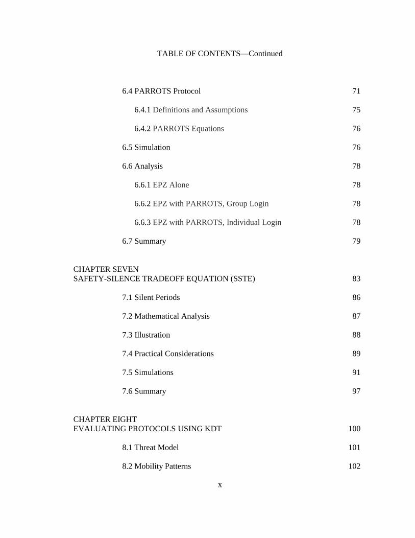
Table 1.1 Location Privacy Techniques Using Dummy Events 9
Table 4.1 Privacy Measurement of Random Pattern Scheme Trajectories 47
Table 4.2 Privacy Measurement of Random Pattern Scheme 49
Table 4.3 Simulation Data for Scenarios 52
Table 5.1 Location Privacy Attacks By LBS Administrator 60
Table 7.1 Safety-Silence Tradeoff Simulation Parameter 94
Table 8.1 KDT Simulation Parameter 101
Table 8.2 Desired Properties and Location Privacy Models 115
Table 8.3 Network Overhead and Location Privacy Models 119
Table 8.4 Anonymity Metrics and Location Privacy Models 119
Table 8.5 Privacy Protocol Performance (Urban Mobility Pattern) 128

xiii
LIST OF FIGURES
Figure 1.1 Spatial Cloaking in a Series of Three Snapshots 4
Figure 1.2 V2V and V2I Communication Scenarios 6
Figure 1.3 Location Privacy Preserving Mechanisms 7
Figure 2.1 DSRC Protocol Stack 15
Figure 3.1 Desired Properties of VANETs 31
Figure 3.2 Expected Distance Diagram 41
Figure 4.1 Trajectories 44
Figure 4.2 Mobility Patterns 45
Figure 4.3 Rotation Patterns 47
Figure 4.4 Modified Rotation Patterns 48
Figure 4.5 Effect of Realistic Roadway Rotation on Deanonymization 50
Figure 5.1 EPZ Grid 59
Figure 5.2 Average Anonymity Set Size by EPZ Size, 10% LBS Users 64
Figure 5.3 Entropy of Average Anonymity Set Size vs. EPZ Size,
10% LBS Users 64
Figure 5.4 Tracking Probability vs. EPZ Size, 10% LBS Users 64
Figure 5.5 Average anonymity set size vs. EPZ size, 20% LBS Users 65
Figure 5.6 Entropy of Average Anonymity Set Size vs. EPZ size,
20% LBS Users 65
Figure 5.7 Tracking Probability vs. EPZ Size, 20% LBS Users 65
Figure 6.1 LBS Anonymity Sets 73
Figure 6.2 LBS-RSU Collusion 74

xiv
LIST OF FIGURES—Continued
Figure 6.3 Comparison of EPZ and PBD Models 80
Figure 7.1 Maximum Possible Collision Combinations 89
Figure 7.2 Relationship Between BSMs and Potential Collisions 90
Figure 7.3 Four Vehicles at an Intersection of Two Two-Lane Roads 92
Figure 7.4 Six Vehicles at an Intersection of a Two-Lane Ro93
and a Four-Lane Road 93
Figure 7.5 Intersection Class 1, Probability Scenarios A, B and C 94
Figure 7.6 Intersection Class 2, Probability Scenarios A, B and C 95
Figure 7.7 Class 1 Intersection at Five Levels of Intersection Density 97
Figure 8.1 Stationary Mix Point (SMP) VANET Privacy Protocol 105
Figure 8.2 Roles of Entities in SMP Models (SMP-I And SMP-R) 105
Figure 8.3 Group Leader Relay Point (GLRP-2) VANET Privacy Protocol 107
Figure 8.4 Roles of Entities in GLRP-2 Model 108
Figure 8.5 On-The-Fly Point (OTFP) VANET Privacy Protocol 111
Figure 8.6 Roles of Entities in OTFP Models 112
Figure 8.7 Average Anonymity Set Size Increased with Vehicle Density 121
Figure 8.8 Average Anonymity Set Size Decreased with
Number of Mix Points 122
Figure 8.9 Distance Deviation Fluctuated with Vehicle Density 123
Figure 8.10 Distance Deviation Decreased with Number Of Mix Points 124
Figure 8.11 Time Of Anonymity Remained Consistent with Increasing
Vehicle Density 125

xv
LIST OF FIGURES—Continued
Figure 8.12 Number of Vehicles Anonymized Increases with Density 126
Figure 8.13 K vs. Trajectory k-anonymity 129
Figure 8.14 Information Entropy 130
Figure 8.15 Tracking Probability 131

xvi
LIST OF ABBREVIATIONS
LBS Location Based Service
FPLQ Frequent Precise Location Query
IoT Internet-Of-Things
VANET Vehicular Ad-hoc Networks
DSRC Dedicated Short Range Communications
WAVE Wireless Access in Vehicular Environments
MAC Layer Media Access Control Layer
FPL Frequent Precise Location
TTP Trusted Third Party
PII Personally Identifiable Information
V2V Vehicle-to-Vehicle
V2I Vehicle-to-Infrastructure
RSU Road Side Unit
CPL Continuous Precise Location
EPZ Endpoint Protection Zone
PBD Privacy-By-Decoy
RRVT Random Rotation of Vehicle Trajectories
SSTE Safety-Silence Tradeoff Equation
FCC Federal Communications Commission
WSMP WAVE Short Message Protocol
PSID Provider Service Identifier

xvii
LIST OF ABBREVIATIONS—Continued
PKI Public Key Infrastructure
GLRP-2 Group Leader Relay Point with Members Joining in Pairs
OBU On Board Unit
VIN Vehicle Identification Number
PII Personally Identifiable Information
CA Certification Authority
TTP Trusted Third Party
CRL Certificate Revocation List
CAD Combinatorial Anonymity Degree
ZRK Zone-based Receiver k-anonymity
EAD Entropy Anonymity Degree
TAC Traceable Anonymous Certificate
BI Blind Issuer
LPRs License Plate Readers
OTFP On-The-Fly Point
TMSs Traffic Management Systems (TMSs)
IoC Internet-of-Cars
IoV Internet-of-Vehicles
AS Anonymity Set
SD Short-term Disclosure
LD Long-term Disclosure

xviii
LIST OF ABBREVIATIONS—Continued
PARROTS Position Altered Requests Relayed Over Time and Space
GPA Global Passive Adversary
SMP Stationary Mix Point

1
CHAPTER ONE
INTRODUCTION
This research addresses a general vehicular network location privacy problem: To
what extent can a vehicle protect itself against surveillance even while querying a
location based service (LBS), which may require frequent hyper-accurate location data?
Let us call this the frequent precise location query (FPLQ) problem.
It may be intuitive to think of protecting the privacy of a human being, a driver,
rather than the privacy of a vehicle, a car. However, it has been shown that vehicles,
particularly cars, are devices as personal as mobile phones. In other words, if you can
locate a person’s car, you can generally locate the person, at least while the car is turned
on. Futher, the techniques discussed in this research are performed by devices, not
people. The FPLQ problem is after all an Internet-of-Things (IoT) problem, not a human
problem, and so this work discusses protecting the vehicle, not the person, though the
intent of the privacy methods is to provide benefit to humans.
The vehicular ad-hoc network (VANET) presents location privacy challenges of
special complexity. In the United States VANET standards are specified by Dedicated
Short Range Communications / Wireless Access in Vehicular Environments
(DSRC/WAVE). These standards call for media access control layer (MAC layer)
transmissions of precise vehicle locations 10 times per second. DSRC can be used to
access the Internet, including LBS applications which may also require frequent precise
location (FPL) data.

2
The privacy issue is not moot because of E911. It is possible for motorists to
confuse traffic monitors even if they own mobile devices by simply turning them off or
by switching devices with other people. US DOT by requiring VANETs may not allow
drivers to turn systems off except for specific privacy purposes for which provisions have
been made in IEEE 1609.2. Moreover, the Principle of Least Privilege remains a well-
respected, fundamental and enforceable information security policy. It dictates that
privacy defenders cannot fail to protect location data from one attacker simply because
another potential attacker has access. Transportation monitors would work on DSRC
systems completely independently from the E911 system. Transportation monitors should
only be given access to such data if it is deemed important by whoever sets up the
transportation system. The same is true for transportation-oriented LBSs, such as Waze or
Google Navigation. If LBS owners were to allow administrators to casually monitor
users, the LBS may be exposed to legal risks. Plus, there may be a moral issue, a business
perception issue.
Without privacy protections in place, wireless eavesdroppers or malicious LBS
administrators could track specific vehicles, or cross-reference vehicles’ precise origin
and termination geographical coordinates with home and work addresses, perhaps
revealing (deanonymizing) a vehicle at a given location at a given time. Because motor
vehicles tend to move at high speeds in predictable patterns along prescribed routes, their
mobility patterns may make vehicles more vulnerable to location privacy attacks than,
say, pedestrian mobile phone users. Deanonymization could occur at either the MAC
layer or higher layers. MAC layer VANET systems require vehicles to transmit FPL.
LBS applications sometimes have similar requirements. If there is collusion, MAC layer

3
data could be used to circumvent application layer (APP layer) protections such as
spatial-temporal cloaking.
The vehicular location privacy problem is important because driver location data
can be misused. With the assistance of hackers or malicious insiders, employers might
monitor an employee’s car parked at a competitor’s office (revealing an employee’s job
interview) or at specialized medical facilities (revealing an employee’s health condition).
Eavesdroppers could even monitor law enforcement vehicles. It is not difficult to
construct privacy breaches arising from vehicle surveillance by spouses and ex-spouses,
or paparazzi and other stalkers. In fact, the problem is important enough to have been
recognized by national legislators. Proposed national level legislation in the United States
to address digital location privacy threats includes the Location Privacy Act and the
Geolocation Privacy and Surveillance Act.
The location privacy challenge from a technical standpoint is large-scale and
complicated in VANETs. Equipment supporting wireless/wifi networks is already being
installed in new vehicles. Industry representatives estimate that 90% of vehicles will be
wifi-connected within the decade [1]. LBS usage continues to grow rapidly [2] and is
expected to expand to VANET platforms [3]. Standards governing VANETs [4] provide
data fields for future privacy protocols, but the specifics of these protocols remain open
research questions.
Spatial cloaking has been a standard solution to the LBS location tracking
problem. The idea is, if k LBS users are operating in a spatial area, s, then k,s-privacy (a
derivative form of k-anonymity [26]) is achieved [14]. The problem is, if LBS requests
are repeated frequently over time, and only one of the k LBS users is consistent

4
throughout the set of cloaked requests, then that user is exposed. See Figure 1.1.
Researchers have modified spatial cloaking to preserve k-anonymity even when LBSs
receive frequent requests. However, no research has been performed which addresses the
following problems. First, cloaking requires a trusted third party (TTP) or cloaking
proxy, which may be unnecessary additional overhead. Second, cloaking is ineffective in
low vehicle densities, especially if only one user is using LBS in the given vicinity.
Perhaps because of the success of cloaking, other privacy methods remain
relatively under-researched. In vehicular settings for example, dummy event and active
decoy methods may be effective. A dummy event is a message containing false data, sent
in order to help conceal a genuine message. Dummy events and genuine messages are
sent by the same entity. Dummy events function analogously to aircraft countermeasures,
such as flares. An active decoy, on the other hand, is false data sent by an entity other
than the entity seeking to be camoflauged. This research includes an examination of the
tradeoffs between safety and privacy using dummy event and active decoy methods.
12
5
7
10
8
4
9
31
2
7
10
8
4
9
31
2
7
10
8
4
9
3
5 5
6 6 6
Figure 1.1: Spatial cloaking in a series of three snapshots. Vehicle 5 maintains k,s-
privacy at each snapshot but all three snapshots analyzed together may reveal the vehicle.

5
The literature refers to several forms of privacy. Identity privacy is sometimes
referred to as anonymity, pseudonymity or unlinkability with personally identifiable
information (PII). This is often achieved by the use of pseudonyms. Location privacy
refers to the unlinkability of PII with a geographical position, and further, the
unlinkability of one pseudonym with another by using location data. Query privacy
would make unlinkable to the user’s PII, not only the location of the user, but also the
particular query made or query service used. Privacy must be constrainable, as in the
cases of conditional privacy and revocability. This research focuses on location privacy.
1.1 Network Model and Threat Model
Vehicles in VANETs can communicate vehicle-to-vehicle (V2V) or vehicle-to-
infrastructure (V2I). When contacting LBS vehicles communicate V2I through a wireless
access point called a roadside unit (RSU). Figure 1.2 shows how vehicles may
communicate with LBS via multi-hop V2V. The present research excludes other forms of
communication, such as cellular and WiMax.
Powerful RSU system administrators may have access to one, many or all RSUs.
If LBS administrators have access to RSU data, LBS and RSU location data could be
cross-referenced, as shown in Figure 1.2.
1.2 Vehicle Safety
Vehicle safety has historically been a matter of crash mitigation. Safety belts, air
bags, collapsible steering wheels and other technologies have been designed to reduce the
severity of the consequences of a crash.

6
21
8
RSU Log
T PS X Y
-- -- -- --
t0 2 x2 y2
t0 3 x3 y3
t0 6 x6 y6
t0 7 x7 y7
LBS Log
T LU X Y
-- -- -- --
t0 A x4 y4
t0 B x6 y6
t0 C x7 y7
RSU
LBSV2I
V2V
RSU
6B
7C
collusion
Internet
4A
5
Trusted server
LBS
Server
V2V
3 RSU
Router
Figure 1.2: V2V and V2I Communication Scenarios.
Crash mitigation as a field of study seems to have reached a plateau. A new
direction in automotive safety has arisen in the area of crash prevention. Vehicle
networks have been proposed which would allow every car to compute its trajectory and
the trajectories of other vehicles to alert drivers regarding potential crashes faster than
human response alone would achieve. The US DOT reports such technology could
eliminate 80% of crashes of unimpaired motorists [30].
Besides saving lives, crash prevention technologies such as those predicted in
vehicle networks, if effective, may reduce the price of cars and insurance. Expensive
crash mitigation components, like airbags, may become unnecessary, and may be
superseded by more cost-effective crash avoidance components.

7
1.3 Location Privacy Theory and Implications
Shokri [10] suggests there are four methods for preserving location privacy:
hiding events, adding dummy events, obfuscation and anonymization. See Figure 1.3.
Methods can be used individually or in combination to develop defenses.
Methods vary in effectiveness in vehicular settings at the MAC and APP layers.
As shown above some prior techniques have proven ineffective against APP layer queries
requiring continuous precise location (CPL), a.k.a. frequent precise location (FPL).
1.4 Related Work
The literature relevant to vehicular location privacy research can generally be
divided into two areas: papers which present MAC layer solutions to narrow vehicle-
network-specific technical challenges, and papers which present broadly applicable
theoretical concepts of location privacy. The vehicle-network-specific literature largely
ignores dummy event solutions. The broader theoretical literature ignores dummy event
Obfuscating
Dummifying
Hiding
To
ols
Anonymizing
Ap
plic
ati
on
s
Us
ers
Entities Methods
Ob
se
rva
ble
Ev
en
ts
Ac
tua
l
Ev
en
ts
Ob
se
rva
tio
n
Ob
se
rve
d
Ev
en
ts
Figure 1.3: Location privacy preserving mechanisms.

8
solutions at least partly because of the Privacy Universality assumption, the idea that all
or most users desire privacy. However, if privacy is desired by only a small subset of
people, and not by all or many people, then it may be erroneous to conclude that dummy
events would cause excessive overhead, even in pervasive computing environments.
It is difficult to create realistic dummies. One paper [11] reported this problem
when trying to use a trajectory database of vehicle movements. No literature to date,
except [50], has examined the possibility of using “live” geographical coordinates for
LBS FPL queries, yet these coordinates are readily available to vehicular LBS users.
At least six previous works have studied the use of dummy events in protecting
location privacy. See Table 1.1. Some [11] suggest dummy vehicle locations be
generated by adding noise to traces from a trip planner. Another [12] proposes generating
dummy locations in the same neighborhood as the genuine current location. Still another
[13] recommends generating dummy locations entire trajectories, full trips, using
algorithms which offer realistic vehicular mobility modeling and derive positions from
databases of previously-recorded real driver locations. One paper [14] advocates dummy
location generation using either a local grid called a virtual grid, similar to [12], or a
virtual circle, which ensures k,s-privacy. The paper in [15] recommends a scheme which
randomly generates dummy locations rotating with movement patterns that consistent
with observed human movement, though not vehicle movement. Researchers in [16]
studied dummies in packet routing, not directly relevant to this study.
None of these studies except [13] generate dummies from realistic vehicular
mobility models. None consider the threat model in which LBS administrators collude
with RSU administrators. None use active decoys, i.e. false locations (dummy events) of
9
real vehicle locations in real time transmitted by vehicles other than the target vehicle.
Besides the Endpoint Protection Zone (EPZ) model [28] and Privacy-by-Decoy (PBD)
model [50] we are aware of no study to date which has examined the deanonymization of
endpoints in VANETs under LBS/RSU collusion.
In sum, a new body of research is needed to fill the present gap between desired
vehicle network properties and existing solutions. It is possible that some location
privacy methods, such as dummy events, may be more applicable than originally
assumed and should be investigated further. It is the goal of the present study to begin to
fill this gap.
Table 1.1
Location Privacy Techniques Using Dummy Events
Authors Methods Category
You, Peng and Lee (2007) [15] Random trajectory Spatial shift
Lu, Jensen and Yiu (2008) [14] Virtual grid, virtual circle Spatial shift
Chow and Golle (2009) [11] Google Maps poly line Trajectory
database
Kido, Yanagisawa and Satoh
(2009) [12]
Moving in a neighborhood Spatial shift
Krumm (2009) [13] Data gathered from GPS receivers,
modified with noise
Trajectory
database
Alnahash, et. al. (ASEE, 2014)
[51]
Random trajectory confined to road grid Spatial shift
Corser, et. al. (IEEE, 2014) [50] “Live” dummies generated by active
vehicles
Active decoy

10
1.5 Problem Statement
The goal of vehicular network privacy research is to provide to those who desire it
the appropriate balance between (a) vehicle safety, i.e. active transmission of heartbeat
messages, without silent period, (b) network efficiency, i.e. low latency, low congestion
and low computational and storage overhead, (c) application availability, i.e. access to
LBS even if requiring FPL, and (d) desired level of privacy or transparency.
A successful vehicular privacy system should (1) accommodate vehicular
mobility patterns, (2) defend against collusion by MAC and APP layer attackers, (3)
produce privacy solutions for individual motorists that do not depend on cooperation by
large numbers of other motorists or by trusted third parties, and (4) function in low
vehicle densities, notably during the transition period between system initialization and
full saturation, (5) provide protection even when applications require FPL, and (6)
provide protection over a geographical range beyond any particular vehicle’s
communications range.
Current solutions do not achieve the attributes listed above. Specifically, privacy
literature scarcely covers dummy event solutions, which may be useful in vehicular
scenarios. During the early stages of the transition period between 0% saturation and
~100% saturation of vehicle network equipment deployment, network congestion will be
of lesser concern, making dummy event solutions a possible interim choice. Further, in
low density situations and situations which require FPL queries by LBS, spatial-temporal
cloaking will not achieve its highest privacy levels. Finally, it has yet to be determined
the percentage of vehicle users who will want any privacy at all. If many prefer
transparency to privacy, then dummy methods for sparse users may be a viable option.

11
Dummy event and active decoy methods may improve solutions to some vehicle location
privacy problems. This indicates the need for additional research quantifying the
tradeoffs between vehicle safety, network efficiency and privacy.
1.6 Research Objectives and Research Questions
The objectives of this work are to identify the properties of effective privacy-
preserving VANETs, suggest novel protocols, evaluate the effectiveness of privacy
protocols, and quantify tradeoffs between safety and privacy. Simulations address the
following research questions.
What are the properties desirable for privacy-preserving protocols?
What solutions, with a special focus on types of dummy event solutions,
might achieve some or all of these properties?
How can these properties be measured? Especially, how can privacy be
measured in terms of anonymity, distance and time? What new metrics might
be devised and how would new metrics compare with previous ones?
What effect do vehicular mobility patterns have on privacy protocols
involving dummy events?
What effect do dummy methods have on safety? That is, what duration of
silent period is required for dummy methods versus prior solutions?
1.7 Methodology
This research provides theoretical analysis, formulas, and simulated results using
realistic vehicle mobility patterns to evaluate privacy protocol performance in terms of
vehicle safety (duration of silent period) and privacy in terms of anonymity, distance and
time. To evaluate safety-privacy tradeoffs, simulations varied silent period durations and

12
determine how many vehicles would appear in the average anonymity set given varying
vehicle densities and LBS user percentages. At the MAC layer the anonymity set would
be the vehicles in the mix zone. At the APP layer it would be the vehicles in the LBS
cloaking region or active decoy set.
1.8 Research Contributions
The research has yielded the following contributions.
First, it has enumerated a consistent set of desired properties of vehicle
networks and formally added undeanonymizability, efficiency and user
control to the list.
Second, it has presented new privacy metrics specific to vehicular privacy
analysis, specifically anonymity (K), distance deviation (D), and anonymity
time, (T), or KDT for short. These apply specifically to FPL and CPL.
Third, this work resulted in a new way to use the random rotation of vehicle
trajectories (RRVT) in order to protect location privacy over short distances.
Fourth, it resulted in a new method of protecting location privacy over longer
distances and lengths of time using endpoint protection zones (EPZs).
Fifth, this work developed a way to achieve privacy by decoy (PBD), i.e. to
collude with other vehicles in motion to protect privacy against very powerful
adversaries.
Sixth, the research produced an equation, the safety-silence tradeoff equation
(SSTE), which serves as a way to quantify the cost/benefits of absent BSMs or
silent periods on safety/location privacy of vehicles.

13
1.9 Outline of Dissertation
The rest of this document is organized as follows. Chapter Two enumerates
desired properties of VANETs. Chapter Three describes how these properties are
quantified. Chapter Four presents a new privacy model, RRVT, and evaluates its
performance. Chapter Five presents a new privacy model, EPZ, and evaluates its
performance. Chapter Six presents a new privacy model, PBD, and evaluates its
performance. Chapter Seven presents SSTE, a mathematical equation for evaluating the
cost that silent periods have on safety provided by DSRC. Chapter Eight presents KDT, a
new way to measure privacy in CPL/FPL contexts. Chapter Nine concludes the
dissertation and outlines a path for future work.

14
CHAPTER TWO
DESIRED PROPERTIES OF VANETS
First and foremost, DSRC was designed to save lives and reduce injury. Cellular
communications between vehicles were deemed too slow to be used to prevent vehicle
crashes. Sensors were deemed limited because they would not always function in
conditions without clear line-of-sight between vehicles. Consequently, a new set of
super-low-latency protocols were developed, and a new spectrum assigned specifically
for vehicles. The Federal Communications Commission (FCC) dedicated a 75 MHz
spectrum in the 5.9 GHz band for a new set of protocols, called DSRC in the United
States [5].
DSRC features two full distinct network/transport layer protocols. See Figure 2.1.
The first, WAVE, Wireless Access for Vehicular Environments, features WAVE Short
Message Protocol (WSMP). WSMP would typically be used in V2V safety applications,
including safety services which use SAE J2735 message protocols that include a message
type called a Basic Safety Message, BSM, also referred to as a heartbeat message. The
second, IPv6/TCP/UDP, would typically be used in V2I, especially when accessing
infotainment applications.
DSRC was specifically designed to accommodate privacy. Unlike traditional
networks, endpoints do not communicate true MAC addresses. Temporary MAC

15
Traffic Management
and Other Applications
802.11p
IEEE 1609.4
IEEE 802.2
IPv6
TCP/UDPIEEE 1609.3
(WSMP)
SAE J2735
SAE J2924.1IEEE
1609.2
(security)
Safety Applications
Figure 2.1: DSRC Protocol Stack. DSRC includes traditional protocols such as IPv6 and
TCP/UDP, but also new protocols such as WAVE Short Message Protocol (WSMP) and
SAE J2735.
identifiers, pseudoIDs, are switched from time to time [5]. In other words, privacy
capabilities exist in DSRC that are not present in traditional networks.
As research into the implementation of VANETs has advanced, researchers have
continued to identify and examine desired properties of vehicle networks. In the early
days, researchers focused almost exclusively on safety. Today security features involving
trust and privacy have been growing in popularity.
This chapter examines twelve desired properties, concentrating especially on their
relevance to location privacy. Each property below is defined and described, including
the method by which it was measured in simulations.

16
2.1 Property 1: Collision Avoidance
BSMs must maximize safety.
To achieve collision avoidance, vehicles inform each other regarding whether or
not they are on a trajectory to collide. In VANETs this is accomplished using BSMs.
BSMs must be fast, frequent, and localized, and include the transmitting vehicle’s precise
position, velocity and direction at precise times. For BSMs, fast means ultra low-latency
wireless communication using 802.11p which omits BSS and associated MAC sublayer
overhead [5].
Privacy protocols diminish safety when they include a silent period, i.e. a time
span when no BSMs are transmitted. All of the protocols evaluated in this research were
tested using a fixed, 30-second silent period. The total amount of silence can be
computed by multiplying the number of vehicles anonymized by the time of silence (30
seconds). Since the models anonymized roughly the same number of vehicles and the
silent period was constant the models performed equivalently with respect to their impact
on safety.
2.2 Property 2: Authentication
BSMs must be trustworthy.
Vehicles must be able to trust the authenticity of each others’ BSMs. To achieve
authentication, BSMs must include valid digital signatures. Because digital signatures
provide quick, low-overhead authentication, they have long been accepted as the most
effective mechanism to ensure authentication and message integrity in vehicular
environments where nodes may often be in transmission range of each other for only a
brief time [33].

17
Digital signatures do not provide confidentiality, but confidentiality is not
important since BSM data do not contain secret information. In fact, BSM data are
designed to be transparent for safety reasons, so confidentiality would be
counterproductive. However, this lack of confidentiality, coupled with verification of
credentials provided by the digital signature, also makes BSMs vulnerable to privacy
attacks.
Digital signatures defined in IEEE 1609.2 [4] include Provider Service Identifier
(PSID). The PSID indicates the application that will use the data in the payload, so the
PSID is analogous to a port number in TCP. It is possible not all BSMs will contain
identical PSIDs, in which case an eavesdropper might be able to track a vehicle by using
PSIDs within the digital signature. All DSRC privacy protocols suffer from this particular
deficiency, so we do not consider it when determining the rating.
Privacy protocols diminish authentication effectiveness when they introduce
vulnerabilities or impair performance in processing or accessing digital signatures. Let us
define the latter as public key infrastructure (PKI) efficiency. In each model except
Group Leader Relay Point with members joining in pairs (GLRP-2) it was assumed that
there would be multiple certificates per on-board unit (OBU) as in [63]. In GLRP-2 it was
assumed that each vehicle belonging to a group would have that same number of
certificates as the other models, plus additional group signature. The V2V
communications necessary to establish the group, plus the communications necessary to
relay and convert messages to the LBS, represent additional impairment of PKI
efficiency and therefore the GLRP-2 model was rated lower than the other models.

18
2.3 Property 3: Pseudonymity
BSMs must not reveal real identities of vehicles or owners.
To achieve pseudonymity, a type of identity privacy, BSMs must use
pseudonyms, or pseudoIDs, each of which having a corresponding digital certificate.
Except in circumstances requiring accountability or revocability, described below,
pseudoIDs and their certificates are unlinkable to the vehicle identification number (VIN)
of the vehicle and to the personally identifiable information (PII) of the vehicle owner.
In the literature the term, unlinkability, may refer to the inability to correlate
vehicle identities with pseudoIDs, but it may also refer to the inability to correlate
between multiple pseudoIDs of a particular vehicle. To avoid ambiguity, we refer to the
former as pseudonymity and to the latter as either untrackability or untraceability, defined
below.
Privacy protocols diminish pseudonymity when they risk linkage between
pseudoID and VIN or PII. There is a natural tradeoff between authentication by digital
signature and pseudonymity by pseudoID. For authentication to be fast and efficient, the
fewer the pseudoIDs and certificates the better; for pseudonymity, the more the better.
Consequently, for the same reason that the GLRP-2 model was rated lower than the other
models in terms of Property 2, it was rated higher than the other models in terms of
Property 3. That is, additional pseudonyms slow down the authentication process, but
they at the same time add an additional layer of pseudonymity.
2.4 Property 4: Untrackability
PseudoIDs in currently transmitted BSMs must not be linkable to pseudoIDs in
immediately preceding BSMs from the same vehicle.
19
If a vehicle were identified (marked), and its pseudoID linked to PII even a single
time, then the vehicle could be monitored as long as its BSM used that same pseudoID.
Hence this property may be appropriately referred to as real-time location privacy.
To achieve untrackability, a type of location privacy, BSMs must use multiple
pseudoIDs, rotating between them frequently, on average every 5-10 minutes. A single
vehicle may contain several, or even thousands of pseudoIDs, each with its own digital
certificate. By periodically changing between many pseudoIDs theoretically a vehicle
could only be tracked while a particular pseudoID was in use subsequent to the vehicle
being marked [5].
Privacy protocols diminish untrackability when they risk linkage between current
pseudoIDs and their immediately preceding pseudoIDs. There is a natural tradeoff
between authentication by digital signature and untrackability. For authentication to be
fast and efficient, the fewer the pseudoIDs and certificates the better; for untrackability,
the more the better. If a pseudoID switching technique in a privacy protocol includes a
silent period when no BSMs are transmitted, there could also be a tradeoff between
collision avoidance and untrackability.
The group model provides no more barriers to tracking than the other models,
because, while there more pseudonyms are involved, the ability of an eavesdropper to
determine which vehicle belongs to a given signal (blip) does not depend on pseudonym.
Under the assumptions in this paper, a vehicle is marked upon entering the region. No
matter what identifier the vehicle is transmitting, the geographical coordinates alone are
sufficient to track it because it is transmitting frequently, every 100 ms. Any vehicle
which changes identifier is only protected from tracking if there are other members in its

20
anonymity set. Untrackability is accomplished, not by pseudo-identity, but by mixing.
(Refer to the discussion on unlinkability in the prior subsection.) In sum, all models are
equivalently untrackable.
2.5 Property 5: Untraceability
PseudoIDs in current or past BSMs must not be linkable to other pseudoIDs from
the same vehicle, except by proper authorities.
To achieve untraceability, BSMs must be transmitted using multiple pseudoIDs,
switching between them, as in untrackability, above. However, the property of
untraceability is distinct from untrackability. By this paper's definition, “tracking” a
vehicle would be performed in real-time, while the vehicle is in motion. “Tracing” the
vehicle would be a matter of historical investigation, to determine what vehicle was at
what location at what time. Hence this property may be appropriately referred to as
historical location privacy.
Historical evidence-gathering has been used by proper authorities, such as courts
of law (see accountability, below). But tracing could also be used by stalkers or paparazzi
for gathering background information on vehicles to establish locations at specific times
or to establish transportation patterns of people under unauthorized surveillance.
Privacy protocols diminish untraceability when they risk linkage between
pseudoIDs and preceding pseudoIDs for a given vehicle. There is a natural tradeoff
between authentication by digital signature and untraceability. For authentication to be
fast and efficient, the fewer the pseudoIDs and certificates the better; for untraceability,
the more the better. If a pseudoID switching technique in a privacy protocol includes a
21
silent period when no BSMs are transmitted, as in this study, there could also be a
tradeoff between collision avoidance and untraceability.
To the extent that group signatures add an additional layer of identity privacy via
pseudonymity, group signatures provide better protection against tracing.
2.6 Property 6: Accountability
PseudoIDs must be linkable to PII by proper authorities.
Sometimes it is beneficial to link a vehicle to its owner’s identity and/or its
location, such as when a vehicle may have been used in a crime or involved in an
accident. It may be argued that a privacy protocol without the property of accountability
would introduce more risk to the public by concealing criminals than it would introduce
security to the public by protecting people’s privacy.
To achieve accountability, a certificate authority (CA) or other trusted third party
(TTP) must protect vehicle and owner identity and location while maintaining the
capability to link this information with pseudoIDs if requested by a proper authority. This
is sometimes referred to as conditional privacy.
Privacy protocols diminish accountability when they do not provide a secure
mechanism for linkage between pseudoIDs and vehicle/owner identity and location.
There is a natural tradeoff between trust and privacy, and this balance must be struck in
the property of accountability. The TTP must be able to determine the circumstances
under which a proper authority may circumvent a privacy protocol and reveal the true
identity associated with a pseudoID.
All of the simulated protocols require identities and pseudo-identities with digital
certificates issued by a CA which could deanonymize the transmission if, for example,
22
required to do so by a court order. The group model provides for both a CA to enable
single-entity digital signatures and a group manager to enable group signatures. All
models provide the same technical level of accountability. It is assumed that it would be
more difficult for a law enforcement authority to obtain a warrant and receive
deanonymized vehicle information from two entities than from just one, so the group
model is rated inferior to the others because it includes both the CA and the group leader
to cooperate in order to achieve accountability.
2.7 Property 7: Revocability
PseudoIDs and digital certificates must be rescindable.
It is possible that valid digital certificates could be stolen and used maliciously. If
this is detected the certificate should be revoked.
To achieve revocability, a CA or other TTP must provide valid digital certificates
for pseudoIDs while maintaining the capability of rescinding certificates by updating and
distributing a certificate revocation list (CRL) if requested by a proper authority.
Privacy protocols diminish revocability when they impair the distribution of
CRLs securely, quickly and broadly [39]. For authentication to be fast and efficient, the
smaller the CRLs, the better; for effective revocability, some protocols indicate large
CRLs. There is a natural tradeoff between trust and privacy, and this balance must be
struck in the property of revocability. The TTP must be able to determine the
circumstances under which more harm than good comes from BSMs bearing a particular
pseudoID and that the benefit of revoking that pseudoID’s digital certificate exceeds its
cost.
23
Some researchers suggest the group model is infeasible due to limitations of
bandwidth and computation power, since pseudoID schemes create large certificate
revocation lists, CRLs, and associated checking costs, network overhead necessary to
verify that certificates have not been revoked [9].
2.8 Property 8: Anonymity
Location privacy models must maximize indistinguishability between pseudoIDs.
Privacy protocols can be evaluated by anonymity, which we define as the
quantifiable amount of privacy the vehicle’s pseudoID enjoys by using the protocol.
Anonymity could measure identity privacy or location privacy. The pseudoID is the
mechanism which protects identity privacy, therefore it follows that pseudonym
anonymity could measure identity privacy protection. But what about location privacy?
There are four methods of preserving location privacy: obfuscation, hiding events,
adding dummy events, and anonymization [10]. For BSMs, obfuscation is not possible
because precision is required for safety applications. Hiding BSMs is not possible
because safety applications depend on the detectability of BSMs. Adding dummy BSMs
may threaten safety by inducing vehicles to react to nonexistent vehicles; in fact digital
signatures are used to reduce the possibility of malicious fake BSMs. The only remaining
method is anonymization. Since the identities used in BSM transmissions are
pseudonyms, pseudoIDs, the only way to protect privacy in VANETs is by pseudonym
anonymity, or as we call it, anonymity.
It is necessary to make fine distinctions between the terms, anonymous and
pseudonymous, to clarify computational privacy in vehicular network contexts. The
dictionary definition of anonymous is, “not named or identified” [40], a definition which

24
might not apply in networks that require identifiers for communications. When referring
to computers the term, anonymous, may imply a pseudonym which is unlinkable to a
person’s true identity, as in an anonymous post on a blog. This definition introduces
ambiguity with the term anonymity when used as in anonymity set, defined below. We
use the dictionary definition of pseudonymous, “bearing or using a fictitious name” [41]
to indicate unlinkability to PII. Vehicle networks use pseudoIDs, which achieve the
property of pseudonymity. This paper uses the term anonymity as it is used in set theory,
as in an anonymity set [42]. Thus we can define two distinct privacy properties,
pseudonymity and pseudonym anonymity.
To maximize anonymity, location privacy models must maximize the anonymity
set size of each pseudoID. Anonymity has been measured using a range of metrics, not all
of which apply to the evaluation relevant to this paper. Let us set aside l-diversity [17],
t-closeness [18], L1-similarity [44], m-invariance [45][46], and ε-differential privacy
[19]. We also set aside network metrics such as combinatorial anonymity degree (CAD),
zone-based receiver k-anonymity (ZRK) and evidence theory anonymity [47]. These are
all valuable measures of anonymity but they do not measure pseudonym anonymity in the
context of BSMs.
We evaluated pseudoID anonymity of privacy protocols using one or more of the
following metrics: pseudonym anonymity set size, |AS|; entropy of the anonymity set
size, H(|AS|), also called entropy anonymity degree (EAD) [47]; and tracking probability,
Pt. We evaluate each privacy protocol on its ability to achieve indistinguishability
amongst pseudoIDs. Note that the term, pseudoID, can be used for the temporary MAC

25
address at the MAC layer, or the identifier used at the APP layer, including a dummy or
decoy message.
Just as digital signatures may introduce privacy vulnerabilities, as discussed in
authentication, above, BSMs may introduce privacy vulnerabilities which could be used
to reduce anonymity set size by isolating characteristics peculiar to a specific target
vehicle. Some of the data fields in a BSM, for example, could be used by eavesdroppers
to link past pseudoIDs to current ones.
If MsgCount, a sequence number field used for packet error monitoring, is not
reset when pseudoID changes then an eavesdropper could match the sequence numbers of
past BSMs with current BSMs and link the pseudoIDs. If PositionalAccuracy
differed from vehicle to vehicle, then an eavesdropper could link pseudoIDs or even track
this data element instead of tracking pseudoIDs. If SteeringWheelAngle were
misaligned for a vehicle, or if BrakeSystemStatus were in any way distinct for one
vehicle compared to its neighbors it make an easy mark. Perhaps the most concerning
data element is VehicleSize, which provides vehicle length and width accurate to a
resolution of 1 cm. Vehicles are produced in sufficiently various lengths and widths that
this element alone may be sufficient for an eavesdropper to link past and present
pseudoIDs.
All DSRC privacy protocols suffer from this particular deficiency, so we do not
consider it when determining the rating, but the challenge remains: how to implement
fine-grained safety data without exposing driver location.
Privacy protocols diminish anonymity when they do not provide high levels of
indistinguishability (unlinkability) between pseudoIDs, as measured by (1), (2) and (3).
26
Equations (7) and (12) measure distance deviation and anonymity time, respectively.
Equations (1), (7) and (12) are used to compute the composite metric, KDT. The
formulas for all of these equations appear in the following chapter.
2.9 Property 9: Decentralization
BSMs must not be traceable by a single TTP.
Decentralized protocols by definition involve multiple independent TTPs. The
purpose of decentralization is to prevent a single TTP from being able to undeanonymize
vehicles.
To achieve decentralization, BSMs could, for example, include blind signatures,
which require a traceable anonymous certificate (TAC), a certificate issued by two TTPs,
a Blind Issuer (BI) and an Anonymity Issuer (AI). TACs work the same as other digital
certificates, but it would require the cooperation of multiple TTPs to trace back to the
identity of the vehicle. For a full discussion, see [48] and [49].
Privacy protocols diminish decentralization when they fail to call for multiple
independent TTPs. Any protocol could implement blind signatures but the group model
explicitly requires at least two separate credential-issuing entities (TTPs) so GLRP-2 is
evaluated higher than its peers in this regard.
2.10 Property 10: Undeanonymizability
Location privacy models must minimize cross-referenceability.
If vehicles require LBS query results based on precise location data, then
eavesdroppers with access to the content of that data could use map databases or other
cross-references to deanonymize motorists and vehicles. For example, if a driver started

27
her vehicle at coordinates (x,y), her home address, then eavesdroppers could match (x,y)
with the longitude and latitude of the address and possibly identify the driver.
Another method of deanonymization is used in this paper. It occurs when vehicles
enter an ingress point of a region, or when they exit an egress point. Deanonymization
may be possible by using license plate readers (LPRs) at these ingress/egress points and
identifying the vehicle using vehicle registration records.
Cross-referencing could occur in real time in the case of RSU-LBS collusion.
BSMs provide RSU with vehicle FPL and MAC-layer pseudo-identifier of vehicle. So
once deanonymized any eavesdropper with access to RSU or OBU data in
communications range of the target could continuously track the target vehicle. FPL LBS
queries provide LBS with vehicle FPL and APP-layer identifier. If RSU and LBS collude
then LBS could also track the target in real time. If a target vehicle were to go radio silent
with respect to BSMs, but not LBS queries, LBS could continue to track the target. If a
target vehicle were to go radio silent with respect to FPL LBS queries, but not BSMs,
then LBS could still continue to track target using BSMs. This demonstrates the necessity
that vehicles must go radio silent at both MAC-layer and APP-layer to defend against
RSU-LBS collusion.
Combination MAC-layer/APP-layer defenses, such as endpoint protection zones
(EPZ) [28] could enable undeanonymizability even when LBS and RSU collude. Such
defenses could be used in combination with any protocol in this study, however EPZ
defends endpoints only; it does not not defend against LPRs at region border
ingress/egress points.
28
Dummy event methods [11][12][13][14][15] have been researched but none,
except the On-The-Fly Point (OTFP) model, Privacy-by-Decoy (PBD) [50], has
explicitly addressed the RSU-LBS collusion problem beyond the basic defense offered by
EPZ. PBD not only protects against RSU-LBS collusion, but also enables LBS login.
This is the strongest undeanonymizability defense of which we are aware, especially
considering it requires no anonymization server. The other models offer no protection
against deanonymization from cross-referencing or collusion.
2.11 Property 11: Efficiency
Location privacy protocols must minimize network and application overhead and
congestion.
In order to maximize efficiency location privacy protocols must avoid overhead,
unnecessary consumption of bandwidth, memory and computational resources. Network
overhead can be measured by the number (or percentage) of additional messages required
to implement the protocol.
2.12 Property 12: User Control
Location privacy models must maximize individual customization settings.
Not all motorists prefer privacy. Some prefer transparency. Some may prefer to
switch between transparency and privacy. The capability of a location privacy model to
permit end user customization or even the capability to shut off anonymization
altogether, indicates a superior privacy protocol compared to one that does not offer the
feature.
This is an important and often overlooked privacy property. Consider the
following scenarios, all of which involve customizable location privacy.
29
A political candidate may want location transparency when on the campaign
trail, but may want location privacy when meeting with potential donors.
A parolee (or a parole enforcement administration) may want provable
transparency (nonrepudiation) to prove a parolee was driving to work and not
at a criminal meetup.
The owner of a fleet of trucks may not want his drivers to have location
privacy configurable at the driver level, however she may not want her
competitors to know her fleet’s location.

30
CHAPTER THREE
PERFORMANCE METRICS
Now that properties have been defined we need ways to measure how well
protocols perform with respect to these properties. Since this report confines itself to the
FPLQ problem, it omits considerations such as the complexities of encryption or key
distribution, for example. The challenge in front of us is how to keep vehicles
anonymized even when they are connected to an LBS and transmitting precise location
frequently.
3.1 Safety-related Properties
As shown in Figure 3.1, there are four properties involving safety. Property 1,
collision avoidance, is best served when 100% of vehicles transmit BSMs 100% of the
time. However, Properties 4, 5 and 10 require silent periods for switching identifiers.
It would be pointless to switch identifiers without a silent period under FPLQ
because transmissions are so frequent that an attacker could easily see which prior
vehicle switched to which subsequent identifier. Silent periods must be instituted
otherwise ID switching could not be used to achieve anonymity.
Silent periods diminish the effectiveness of safety, but FPLQ solutions studied
here require generally equal durations of silent periods. Consequently this research does
not compare protocols in terms of their safety risks. Rather, it presents the overall safety
risk of using any silent period method to achieve privacy. See Chapter Seven.

31
Figure 3.1: Desired properties of VANETs.
3.2 Trust-related Properties
Four of the twelve properties, 2, 6, 7 and 9, are categorized as trust-related. All of
them involve how encryption keys are used, issued, or maintained. Since a vehicle’s
location is in the open necessarily, for safety reasons, and location is the only data with
which this report is concerned, we omit metrics for measuring the relative value of the
various methods, such as trusted third parties, certificate revocation lists, blind signatures,
etc. All of these matters are important, but none bear directly on the FPLQ problem.

32
3.3 Privacy-related Properties
The remaining four properties, 3, 8, 11 and 12, concern themselves with privacy,
not safety or trust, however not all of them bear directly on our present problem, FPLQ’s.
Property 3, pseudoID creation and usage, for example, depends on choices made by
programmers and standards set by IEEE 1609.2 and SAE J2735. No particular pseudoID
technique would be better or worse under FPLQ conditions.
Property 11, efficiency, meaning the efficiency of the privacy protocol, not the
over all network efficiency, does have a measurable impact and we can compare effects
under differing privacy protocols. See Chapter Nine for this information.
Property 12, user control, might best be evaluated using a rating scale, for
example a zero-to-ten scale. Perhaps zero could indicate the user has no control; that is,
the privacy protocol forces the driver’s car to execute the protocol. Perhaps ten would
indicate that the user could adjust on the fly when and where and how his car is
anonymized. In this study, we used an on-off evaluation. Either the user had some control
(on) or she had none (off).
Property 8, anonymity, may be the most measurable of the pure-privacy
properties. Important work has been done in this area, and has been applied in a range of
situations. However, there are some peculiarities to VANETs that suggest that even more
work needs to be done. Below, see previous work and the new measurement techniques
developed during this research. This dissertation expands the scope of anonymity to
include distance and time, and introduces theoretical estimates and metrics to evaluate
performance of this expended definition of the property of anonymity.

33
3.3.1 Traditional Macroscopic Location Privacy Definitions and Metrics
Microscopic location privacy is defined in [10] to be anonymity at a specific place
and time. On the other hand, macroscopic location privacy is defined as anonymity from
beginning to end of an entire trajectory, i.e. a path or segment of a path traversed by a
user, in this paper, a vehicle. This research examines macroscopic location privacy.
Early VANET privacy research often focused on MAC layer location privacy
problems using microscopic location privacy metrics. More recently researchers have
begun to study application (APP) layer location privacy problems using macroscopic
location privacy metrics. This study belongs to the latter category.
Users are vehicles, not people, because Traffic Management Systems (TMSs)
may require queries with such rapidity and precision that queries are automated. TMSs
therefore are herein considered Internet-of-Things (IoT), a.k.a. Internet-of-Cars (IoC) or
Internet-of-Vehicles (IoV), applications.
The traditional methods can be adapted to macroscopic purposes by replacing
individual entities with trajectories. That is, instead of examining an entity’s anonymity at
a specific point in space and time, examine its trajectory over a region of space and
duration of time. This paper adapts the definitions from [58] to define the metrics below,
however before embarking on that certain more basic definitions must be established,
specifically definitions of privacy which apply to vehicle networks.
Some have defined privacy as user control over information [26], or the degree to
which individuals can determine for themselves when, how, and to what extent location
information about them is communicated [27]. IEEE 1609.2 measures privacy using
anonymity [4]. (The term, anonymity, is defined as in set theory.) This paper defines
34
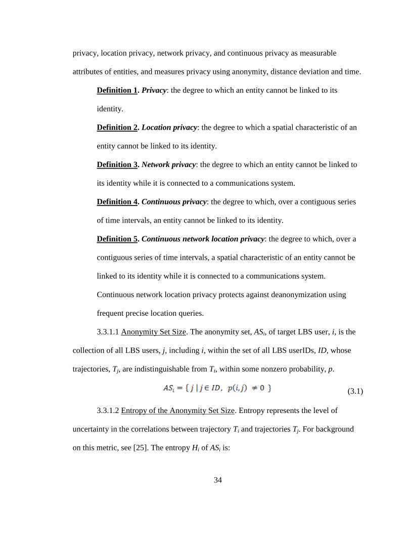
privacy, location privacy, network privacy, and continuous privacy as measurable
attributes of entities, and measures privacy using anonymity, distance deviation and time.
Definition 1. Privacy: the degree to which an entity cannot be linked to its
identity.
Definition 2. Location privacy: the degree to which a spatial characteristic of an
entity cannot be linked to its identity.
Definition 3. Network privacy: the degree to which an entity cannot be linked to
its identity while it is connected to a communications system.
Definition 4. Continuous privacy: the degree to which, over a contiguous series
of time intervals, an entity cannot be linked to its identity.
Definition 5. Continuous network location privacy: the degree to which, over a
contiguous series of time intervals, a spatial characteristic of an entity cannot be
linked to its identity while it is connected to a communications system.
Continuous network location privacy protects against deanonymization using
frequent precise location queries.
3.3.1.1 Anonymity Set Size. The anonymity set, ASi, of target LBS user, i, is the
collection of all LBS users, j, including i, within the set of all LBS userIDs, ID, whose
trajectories, Tj, are indistinguishable from Ti, within some nonzero probability, p.
(3.1)
3.3.1.2 Entropy of the Anonymity Set Size. Entropy represents the level of
uncertainty in the correlations between trajectory Ti and trajectories Tj. For background
on this metric, see [25]. The entropy Hi of ASi is:
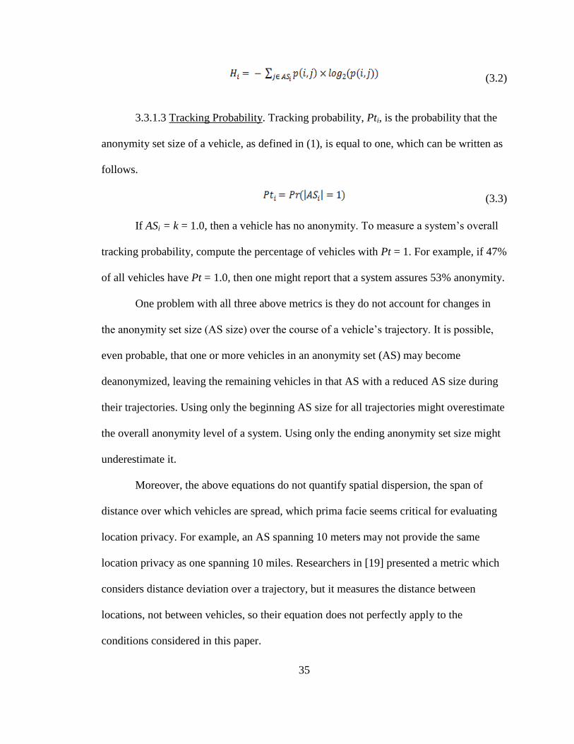
35
(3.2)
3.3.1.3 Tracking Probability. Tracking probability, Pti, is the probability that the
anonymity set size of a vehicle, as defined in (1), is equal to one, which can be written as
follows.
(3.3)
If ASi = k = 1.0, then a vehicle has no anonymity. To measure a system’s overall
tracking probability, compute the percentage of vehicles with Pt = 1. For example, if 47%
of all vehicles have Pt = 1.0, then one might report that a system assures 53% anonymity.
One problem with all three above metrics is they do not account for changes in
the anonymity set size (AS size) over the course of a vehicle’s trajectory. It is possible,
even probable, that one or more vehicles in an anonymity set (AS) may become
deanonymized, leaving the remaining vehicles in that AS with a reduced AS size during
their trajectories. Using only the beginning AS size for all trajectories might overestimate
the overall anonymity level of a system. Using only the ending anonymity set size might
underestimate it.
Moreover, the above equations do not quantify spatial dispersion, the span of
distance over which vehicles are spread, which prima facie seems critical for evaluating
location privacy. For example, an AS spanning 10 meters may not provide the same
location privacy as one spanning 10 miles. Researchers in [19] presented a metric which
considers distance deviation over a trajectory, but it measures the distance between
locations, not between vehicles, so their equation does not perfectly apply to the
conditions considered in this paper.

36
Finally, the above performance metrics do not consider the duration of
anonymity. Privacy protocols perhaps should be considered more effective the longer
they last.
3.3.2 Proposed Metrics
This section presents a composite metric, KDT, for evaluating location privacy
provided by privacy-preserving protocols in contexts which involve FPL queries. The
composite metric uses anonymity quantification based on k, called kj, the anonymity set
size at a specific point in time, tj. It uses a Euclidean distance quantification, , the
degree of spatial dispersion, or average span of distance, between members of an
anonymity set at a specific point in time, tj. And it uses a new metric, T, anonymity
duration, which is the number of contiguous time intervals after t0 which have anonymity
set sizes greater than one. (The first time interval with anonymity set size greater than one
is labeled t0.) The statics metrics, k, d, and t, quantify privacy at specific points in time.
The composite metric, KDT, quantifies the average privacy of a system over a span of
time.
3.3.2.1 Anonymity Duration ( | T | ). Anonymity duration, | T |, is the size of the
set, T, of time intervals, tj, j=0,1,2,…, | T |, over which an entity enjoys continuous
network location privacy. So T is a collection of contiguous time intervals starting from t0
during which the anonymity set size, | ASj |, is greater than one. Formally,
(3.4)
37
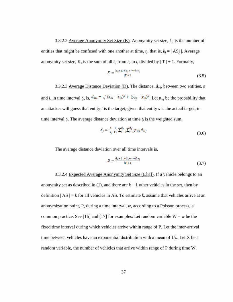
3.3.2.2 Average Anonymity Set Size (K). Anonymity set size, kj, is the number of
entities that might be confused with one another at time, tj, that is, kj = | ASj |. Average
anonymity set size, K, is the sum of all kj from t0 to tj divided by | T | + 1. Formally,
(3.5)
3.3.2.3 Average Distance Deviation (D). The distance, dsij, between two entities, s
and i, in time interval tj, is, . Let psij be the probability that
an attacker will guess that entity i is the target, given that entity s is the actual target, in
time interval tj. The average distance deviation at time tj is the weighted sum,
(3.6)
The average distance deviation over all time intervals is,
(3.7)
3.3.2.4 Expected Average Anonymity Set Size (E[K]). If a vehicle belongs to an
anonymity set as described in (1), and there are k – 1 other vehicles in the set, then by
definition | AS | = k for all vehicles in AS. To estimate k, assume that vehicles arrive at an
anonymization point, P, during a time interval, w, according to a Poisson process, a
common practice. See [16] and [17] for examples. Let random variable W = w be the
fixed time interval during which vehicles arrive within range of P. Let the inter-arrival
time between vehicles have an exponential distribution with a mean of 1/λ. Let X be a
random variable, the number of vehicles that arrive within range of P during time W.

38
Then the probability that X = x at W = w can be written as shown in (3.8). The expected
value of X is shown in (3.9). The expected value of X is the expected value of k.
(3.8)
(3.9)
So, if vehicles arrive at P at a rate of one every five seconds, i.e. λ= , in a given
30-second time interval, i.e. w=30, then the expected value of k = E[k] = E[X] =
(1/5)(30) = 6. By linearity, the expected value of K is the average of all values of k,
which is k, i.e. E[K] = k.
3.3.2.5 Expected Average Distance Deviation (E[D]). It is possible to estimate
distance deviation, d, between two vehicles when certain attributes of the roadway
topology are assumed.
3.3.2.5.1 One Point in Time, One Vehicle in Motion (E[d]). One way to estimate
theoretical distance deviation is to identify an anonymization point and compute the
expected distance between the anonymization point and some deanonymization point of
interest. A unit square region with straight roadways provides mathematically clear
illustration and generally correlates with topologies of government jurisdictions and
roadways.
Assume two vehicles anonymize at the centroid, C, of a square region, R, but that
only one of them continues in motion, and that the motion is at a constant rate of speed in
a straight line. Assume the moving vehicle has an equal probability of driving from C to
any boundary point, B, on the square. What is the expected distance traveled by the
moving vehicle?

39
All four sides of the square are line segments of equal size, so C and the endpoints
of the line segments form, not only similar triangles, but identical triangles, except for
rotation. That is, the average distance from the centroid to one line segment is identical to
the average distance from the centroid to any other line segment on the square.
Let the square be a unit square centered at (0.5,0.5) with the x-axis boundary
spanning from (0,0) to (1,0). The probability density function of a vehicle traveling from
the centroid to any point on the x-axis boundary conforms to the uniform distribution.
(3.10)
The expected distance a vehicle would travel after having anonymized at the
centroid, C, would be the sum of the products of the probability of traveling from C to a
certain boundary point, (x, y), and the Euclidean distance between the centroid and that
boundary point. Since y always equals zero on the x-axis boundary the distance from C to
(x, y) is
(3.11)
To compute the expected distance deviation, sum all possible products by
integrating as follows.
(3.12)
Computing the definite integral above, the expected distance, then, is roughly
0.5739 [57], which is the expected distance deviation from a stationary vehicle remaining

40
at the centroid to a moving vehicle at the time it crosses the boundary of a unit square
region.
3.3.2.5.2 Full Trajectory, Two Vehicles in Motion (E[d]). What if attacker and
defender wish to know the expected distance deviation, not just at the square's boundary,
but over a vehicle's trajectory? With some assumptions it is possible to formulate an
estimate.
Assume the square region, R, has straight roadways intersecting at perpendicular
angles, but that the roadways are not perpendicular or parallel to the sides of the square.
Assume the same anonymization point, the centroid, C, which is also the intersection of
two straight roads. Assume the distance from the centroid to the endpoint of the straight
line road segment is E[dst] as computed in (3.10). See Figure 3.2.
Assume the two members of the anonymity set begin traveling at the same point
in time starting at the same intersection. Finally, assume that both vehicles travel at the
same rate of speed, r, and there is an equal probability that they will proceed in each of
the intersection’s four possible directions.
Then there are four possibilities. First, if the decoy vehicle travels along the same
road as the target vehicle, then d=0 at all points during the trajectory. Second, if the
decoy vehicle travels in the opposite direction of the target vehicle, then d=2l, where l is
the length of road traveled by one vehicle at any given point in time. Third (and fourth),
if the decoy vehicle travels along one of the perpendicular roads, then d=l , where l is
the length of road traveled by one vehicle at any given point in time. There is a 25%
probability of each of the four scenarios. The expected value of d, then, would be as
follows.

41
(3.13)
E[d] evaluates to approximately 0.1988 [57].
3.3.2.6 Expected Anonymity Duration (E[T]). By linearity, the expected
anonymity time is the expected distance of a full trajectory, divided by the constant
movement rate, r. Using terms from (3.12) we can write as follows.
(3.14)
(0,0)
(1,1)
(0.5,0.5)E[dst]
√2 E[dst]
Figure 3.2: Expected distance diagram. E[dst] is the expected distance one vehicle would
travel from the centroid to the boundary of a square region. The dotted square represents
the region, R, a unit square. The solid perpendicular lines, each starting at (0.5,0.5) and
terminating at the boundary of the square, represent road segments.

42
3.4 Summary
Vehicles travel fast, often on very predictable paths. In order for privacy to be
effective, we hypothesize, they not only must be anonymized amongst other vehicles but
there must be significant distance between targets and other members of the anonymity
set. After all, if all the vehicles in an anonymity set are platooned like ducks in a row,
then the distance range of the target’s anonymity is limited. And if a target must
frequently go silent to change identifiers this limits the benefits of both safety from BSMs
and accessibility to the TMS. The results from new metrics are presented in Chapter
Eight.

43
CHAPTER FOUR
RANDOM ROTATION OF VEHICLE TRAJECTORIES (RRVT)
Perhaps the simplest dummy event technique in location privacy models is the
direct spatial shift. An example of this technique would be to send an LBS genuine
coordinates, (x,y), and dummy coordinates, (x+∆x, y+∆y). After the LBS returned its two
results the sender would process those corresponding to (x,y), and discard those
corresponding to (x+∆x, y+∆y). Meanwhile the LBS could not be 100% certain which
coordinates were genuine.
Direct spatial shift fails when the LBS knows the road map, i.e. which coordinates
correspond to roadway positions. If (x+∆x, y+∆y) does not fall on a roadway, then the
LBS would know the genuine position of the sender. This form of deanonymizing a
vehicle’s position is called map deanonymization. In the case of FPLQ, there would be a
great many coordinates sent to the LBS, and if any one of them were obvious fakes, the
entire fake trajectory would fail.
You, Peng and Lee [15] refined the direct spatial shift technique. Instead of
adding or subtracting an offset to (x,y) coordinates, they proposed rotating entire
trajectories, including past and future points. They did not explain how they could obtain
future points of a trajectory, however in vehicular contexts this is possible. Since BSMs
are transmitted by all cars, a local vehicle could use other vehicles’ past BSM
transmissions to manufacture a new future fake/dummy trajectory.
This chapter presents random rotation of vehicle trajectories (RRVT). The
approach was to examine one generic dummy-based scheme applied in a vehicular

44
context. The results were that, with modifications, the scheme may be useful in certain
vehicular situations.
The foundation of this research is presented in [5], which attempted to minimize
the number of dummies required for given levels of short term disclosure (SD), long-term
disclosure (LD) and distance deviation (dst). [5] evaluated human-like trajectories of
mobile users, as illustrated in Figure 4.1 (left). This research evaluated vehicle-like
trajectories as illustrated in Figure 4.1 (right). The paper [5] proposed two dummy
generation methods, random pattern scheme and rotation pattern scheme. The random
pattern scheme would arbitrarily choose a starting point, ending point and points in
between for dummy trajectories. The rotation pattern scheme would ensure overlap,
extending the random pattern scheme by also arbitrarily choosing an intersection point
and rotation angle for dummy trajectories. Recall: The more trajectories overlap, the
lower the LD. See Figure 4.2.
Figure 4.1: Trajectories. Human-like trajectories (left). Vehicle-like trajectories (right).

45
Figure 4.2: Mobility patterns. Human-like patterns (top) and vehicle-like patterns
projected over roadways (bottom).

46
4.1 Demonstration
To illustrate the difference between human-like trajectories and vehicle-like
trajectories consider Figure 4.2. While humans may roam freely and move relatively
slowly, vehicles tend to move in more predictable patterns much more quickly. Figure 4.2
(top) shows how dummies d1 and d2 may be undetectable as dummies because their
movement patterns are human-like.
Figure 4.2 (bottom) shows how dummies d1 and d2 are detectable as fakes in
vehicular contexts. Dummy d1 is detectable because it does not follow a vehicle-like
pattern. Dummy d2 is detectable because, while it moves in a vehicle-like pattern, some
of the positions are not on roadways, or it is easy to detect that it is impossible to move
from one position to another by using a known roadway. Numerical data for the true user
and dummies in Figure 4.2 (bottom) are presented in Table 4.1.
From equations (1), (2) and (3) we can compute SD, LD and dst for this user. See
equations (4), (5) and (6) below.
SD = ( 1/6 ) * ( 1/3 + 1/3 + 1/2 + 1/3 +1/3 + 1/3 ) = 0.3611 (4.1)
LD = 1 / ( 5 + ( 3 – 2 ) ) = 0.1667 (4.2)
dst = ( 1/6 ) * (3.1 + 2.2 + 1.0 + 1.4 + 1.8 + 2.3 ) = 2.0 (4.3)
The scenario above illustrates the random pattern scheme. To illustrate the
implications of the rotation pattern scheme consider Figure 4.3. For human-like
movement rotation angle may be chosen arbitrarily. For vehicle-like movement, because
of often perpendicular roadways, it may be more advantageous to constrain dummy
trajectories to rotations in increments of 90 degrees.
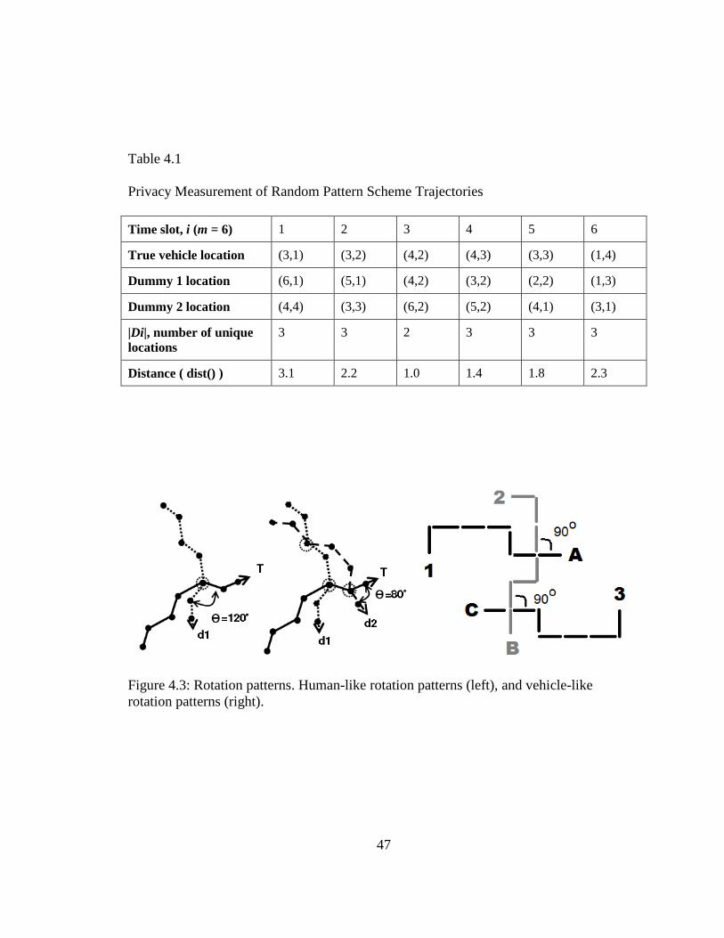
47
Table 4.1
Privacy Measurement of Random Pattern Scheme Trajectories
Time slot, i (m = 6) 1 2 3 4 5 6
True vehicle location (3,1) (3,2) (4,2) (4,3) (3,3) (1,4)
Dummy 1 location (6,1) (5,1) (4,2) (3,2) (2,2) (1,3)
Dummy 2 location (4,4) (3,3) (6,2) (5,2) (4,1) (3,1)
|Di|, number of unique
locations
3 3 2 3 3 3
Distance ( dist() ) 3.1 2.2 1.0 1.4 1.8 2.3
Figure 4.3: Rotation patterns. Human-like rotation patterns (left), and vehicle-like
rotation patterns (right).

48
Restricting the rotation angle offers both advantages and disadvantages.
Constraints may be considered disadvantageous because vehicles have fewer potential
paths to choose from as they move, which degrades SD. However, fewer potential
positions for vehicles implies more potential overlap, which may improve LD. Consider
the data in Table 4.2. Compare the illustration in Figure 4.4 with Figure 4.2 (bottom). The
former shows trajectories more overlapping positions. Since vehicles frequently transmit
precise positions it is possible for a vehicle to construct realistic dummy trajectories using
real or realistic data from other vehicles on the road.
From equations (1), (2) and (3), we can compute SD, LD and dst for this user. See
equations (7), (8) and (9) below.
SD = ( 1/6 ) * ( 1/3 + 1/3 + 1/1 + 1/2 +1/2 + 1/3 ) = 0.5278 (4.4)
LD = 1 / ( 9 + ( 3 – 3 ) ) = 0.1111 (4.5)
dst = ( 1/6 ) * (3.8 + 2.6 + 0.0 + 1.0 + 3.0 + 3.6 ) = 2.0 (4.6)
Figure 4.4 Modified rotation patterns. Human-like trajectories over roadways (left), and
vehicle-like trajectories (right).

49
Table 4.2
Privacy Measurement of Random Pattern Scheme Trajectories
Time slot, i (m = 6) 1 2 3 4 5 6
True vehicle location (3,1) (3,2) (4,2) (4,3) (3,3) (1,4)
Dummy 1 location (7,1) (6,2) (4,2) (5,3) (6,3) (6,4)
Dummy 2 location (6,3) (5,3) (4,2) (4,3) (3,3) (2,3)
|Di|, number of unique
locations
3 3 1 2 2 3
Distance ( dist() ) 3.8 2.6 0.0 1.0 3.0 3.6
4.2 Simulation
We simulated scenarios similar to the illustration above, except we used 20 time
slots and 5 to 25 dummies on a grid of 50x50 squares. We computed SD, LD and dst for
each scenario for each of two conditions, one where roadways were restricted to exist
only in squares which had one dimension evenly divisible by 10, the other with no such
restriction. We ran each scenario nine times and recorded the run with the median
number of trajectory intersections.
The charts in Figure 4.5 show how restricting locations to realistic road paths
reduces the chance of long term disclosure, LD (Figure 4.5, right), while maintaining
minimal effect on short term disclosure, SD (Figure 4.5, left).
4.3 Summary
Dummy locations which are not realistic in vehicular contexts may be detectable
(map deanonymizable) as fakes because location coordinates can be cross-referenced and
validated using maps. This problem can be resolved by restricting dummy vehicles to

50
Figure 4.5: Effect of realistic roadway rotation on deanonymization. The chart at left
shows short term disclosure. The chart at right shows long term disclosure. The left bars
utilize human-like rotation patterns. The right bars utilize vehicle-like rotation patterns.
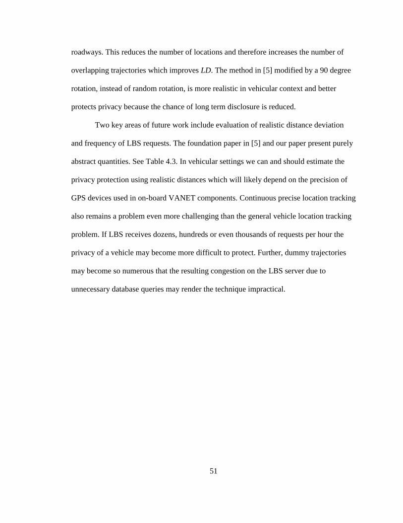
51
roadways. This reduces the number of locations and therefore increases the number of
overlapping trajectories which improves LD. The method in [5] modified by a 90 degree
rotation, instead of random rotation, is more realistic in vehicular context and better
protects privacy because the chance of long term disclosure is reduced.
Two key areas of future work include evaluation of realistic distance deviation
and frequency of LBS requests. The foundation paper in [5] and our paper present purely
abstract quantities. See Table 4.3. In vehicular settings we can and should estimate the
privacy protection using realistic distances which will likely depend on the precision of
GPS devices used in on-board VANET components. Continuous precise location tracking
also remains a problem even more challenging than the general vehicle location tracking
problem. If LBS receives dozens, hundreds or even thousands of requests per hour the
privacy of a vehicle may become more difficult to protect. Further, dummy trajectories
may become so numerous that the resulting congestion on the LBS server due to
unnecessary database queries may render the technique impractical.

52
Table 4.3
Simulation Data for Scenarios
(a) Roads restricted to every 10 squares in grid
dummies 25 20 15 10 5
rr = 10 10 10 10 10 10
SD 0.04052 0.05031 0.06547 0.09464 0.17
LD 0.01282 0.01538 0.02272 0.03703 0.1
intersects 26 22 14 8 2
dst 25.793 22.7686 26.5048 25.8764 20.6967
(b) No road restrictions (rr)
dummies 25 20 15 10 5
rr = 0 0 0 0 0 0
SD 0.03853 0.04761 0.06270 0.09136 0.16666
LD 0.03571 0.04761 0.05555 0.07692 0.16666
intersects 1 0 1 1 0
dst 23.8404 24.5140 25.6914 23.8121 31.6829

53
CHAPTER FIVE
ENDPOINT PROTECTION ZONE (EPZ)
The US DOT is expected to require all vehicles to transmit BSMs. If they require
vehicles to transmit BSMs from the time the ignition system starts through the time the
vehicle is turned off, and if the BSMs are transmitted every 100 ms all along the way as
they are expected to be, then any eavesdropper with a sufficiently detailed map and
sufficiently broad coverage of receivers could identify the driver and track the trajectory
of any vehicle.
Consider that home owner information is publicly available digitally, and Google
Maps API provides latitude and longitude information free of charge. When a vehicle
ignition starts a vehicle, the latitude and longitude could be cross referenced with Google
Maps API to find an address, then the address could be cross referenced with public
records of home owners to identify the driver.
On one hand this could give law enforcement a force multiplier, the capability to
tail suspects without expending the resources of an unmarked car. On the other hand it
could also give drug dealers the ability to monitor suspected undercover cops, or their
families, without requiring the crooks to be physically present at the location under
surveillance. Even without their own network of receivers, legitimate administrators,
malicious administrators, hackers or anyone with access to the mandatory TMS could
achieve the same result.
In vehicular networks when map databases may be used to deanonymize user
locations, we propose location based services, LBSs, be designed so that LBS users are

54
grouped by spatial location, into endpoint protection zones, EPZs. Users in the same EPZ
would share login credentials (if login is required), and remain transmission-silent until
outside of the EPZ, thus preventing an LBS administrator from knowing which particular
user from the EPZ is active—even if the LBS administrator colludes with administrators
of roadside units, RSUs. Simulations in this study used realistic vehicle traffic mobility
models to measure improvements in privacy protection under varying EPZ sizes and
vehicle densities.
This chapter is organized as follows. Section 5.1 discusses link layer threats and
the special strengths and weaknesses of DSRC netowrks compared to other networks.
Section 5.2 does the same, but for hight layers, focusing on applications that are likely to
be part of an intelligent transportation system based on DSRC. Section 5.3 presents
endpoint protection zones (EPZs) and how they might address collusion between LBS
and RSU administrators (or hackers thereof). Section 5.4 presents the metrics sued in the
simulations and section 5.5 presents the simulation setup and performance evaluation.
Section 5.6 concludes the chapter.
Our contribution here is the EPZ model, a solution to the FPLQ problem under
map deanonymization and collusion. We also measure the effectiveness of this solution.
5.1 Privacy Mechanisms, Link Layer (RSU)
Some researchers have proposed complex message anonymization and validation
techniques which, while not concealing vehicles’ precise locations, do conceal identities
of vehicles. To ensure safety-related messages are valid, transmissions include public key
certificates. DSRC standards enable message authenticity by providing standards for
encryption through public key infrastructure (PKI). DSRC standards achieve identity

55
privacy by using temporary identifiers, i.e., temporary media access control addresses,
temp-MACs, and temporary pseudo-identities, pseudoIDs, with their corresponding
digital certificates. Permanent, real identifiers are not transmitted. Certificates are issued
for pseudoIDs—thousands per vehicle—each valid for perhaps five or ten minutes during
the course of a given year. [5]
Temporary identifiers provide only limited location privacy, however. On one
hand, if a malicious system administrator, a tracker, were to mark a target using its temp-
MAC or pseudoID, he would not be able to track a vehicle for very long because the
identifier would periodically change, perhaps every five or ten minutes. On the other
hand, if a single vehicle changed its identifier while all other nearby vehicles maintained
their identifiers, then a tracker might determine a vehicle’s current identifier is correlated
to its prior one. Theoretically a tracker could track a vehicle for a period of time longer
than the duration of the temporary identifier.
Researchers have proposed various solutions to the temporary identifier tracking
problem. They have recommended groups of neighboring vehicles synchronize times
(e.g., silent periods) and locations (e.g., mix zones) when and where they change pseudo-
identities [6]. One subset of proposals describes a group model in which vehicles travel in
clusters, all using the same group temporary identifier, and authenticating messages using
the same group signature [7]. The group model has been shown to be effective in
achieving anonymity in wireless/WSMP communications but it is less effective the lower
the vehicle density, since anonymity level depends on the number of vehicles in each
group. Some researchers suggest the group model is infeasible due to limitations of
bandwidth and computation power, since pseudoID schemes create large certificate

56
revocation lists, CRLs, and associated checking costs, network overhead necessary to
verify that certificates have not been revoked [8].
These solutions do not protect against map deanonymization.
5.2 Privacy Mechanisms, Higher Layers (LBS)
Motorists may be more vulnerable to location tracking when they access an LBS,
such as the TMS. If login is required, the identity used to log in to the LBS may not be
temporary, which may extend trackability time while logged in to the LBS. Further,
transmissions and LBS queries may be correlated, deanonymized, using public databases,
such as home address databases, which may diminish the identity privacy protection
provided by temporary identifiers. Group signatures have been suggested as a solution to
this problem, too [9], though we suggest group logins where the group is defined by an
EPZ. Neither group signatures nor group login protect against map deanonymization, and
neither defends against LBS/RSU collusion.
Some privacy models require a proxy server which acts as a privacy-protecting
intermediary between vehicles and applications. Spatial cloaking schemes usually require
a trusted server. The two basic problems with this technique are cost and trust. There are
additional overhead and hardware costs, and there is the need to trust a server which can
itself become a target or vulnerability.
Spatial cloaking is not always feasible in vehicular situations when LBSs require
precise, continuous vehicle location information. While a single request can be
obfuscated by a spatial cloak, a series of requests makes it ever more difficult to protect
the link between the identity of a user and his location. If a user requests k,s-privacy in
several snapshots, the snapshots might be assembled to identify which user is common to

57
all requests. Of course, if one end of the trajectory could be deanonymized, the user's
identity might be linked with his location.
A few studies have explored the use of dummy events, i.e., counterfeit
transmissions, in continuous, precise location situations. Instead of transmitting a
spatially cloaked region in a single LBS request, a user would transmit multiple LBS
requests, each containing a specific location, perhaps real, perhaps fake. Users would
achieve location privacy by k-anonymity since LBS administrators could not tell which of
k precise locations is genuine. The problem with this solution is under LBS/RSU
collusion the LBS administrator could determine which locations were fake if the request
used a false location. Even if the LBS user used real locations from real vehicles in its
transmission range, the spatial range of the fakes would be limited by the vehicle’s
wireless communications range; that is, the decoy might be undetectable but it might be
so close to the real vehicle that the location privacy achieved would be minimal.
These solutions do not protect against map deanonymization.
5.3 EPZ Model
To illustrate the value of the EPZ model, consider a hypothetical example,
www.HomeOwnerMobile.com, a fictional LBS which displays on your car's dashboard
the names of the owners of homes in view. It might also display the prices of the homes,
if they are for sale, or the most recent price paid, if they are not for sale, assuming this is
public information. Such a service would simplify the process of shopping for a home,
but it would also require continuous precise location information from the vehicle making
the request. What if the shopper does not want LBS administrators (or TMS hackers) to
know his identity? How could the LBS be organized to prevent surveillance?

58
Suppose the LBS is constructed in such a way that LBS users who live near each
other use the same login credentials. Suppose those users remain completely
transmission-silent while driving in their specially designated area near their own home
or workplace, i.e. their endpoint protection zone, EPZ. Then, if there are k users in the
EPZ, each user achieves k-anonymity. The LBS administrator cannot identify which
member of the EPZ is requesting the information. Moreover, since the users are from the
same general location, location-specific advertising could still be effective.
5.3.1 EPZ Grids
In the EPZ model all LBS users in an EPZ protect each others’ location privacy
by using the same login credentials. The EPZ model divides a region, R, of width, W, and
height, H, into grids of rectangles of width, w, and height, h. See Figure 5.1. Let V be the
total number of vehicles in R. Let λ be the ratio of LBS users to V, so the number of LBS
users in R is λV. Assuming a uniform distribution of random variable V in R, the expected
anonymity set size for an LBS user is as follows.
E{ ASEPZ } = k = λVwh/WH (5.1)
5.3.2 Threat Model
Attackers can be categorized by the scope of their surveillance capabilities. If the
attacker can observe the entire system of vehicles, we define him as a global attacker,
even though the scope of the system may only include a single municipality. If the
attacker has access only to a subset of the system, such as the communications range of
an RSU, we refer to the attacker as local. Attackers can also be categorized by their
intent, passive or active, i.e. whether they intend merely to monitor targets or whether
they also intend to mislead or otherwise influence targets.
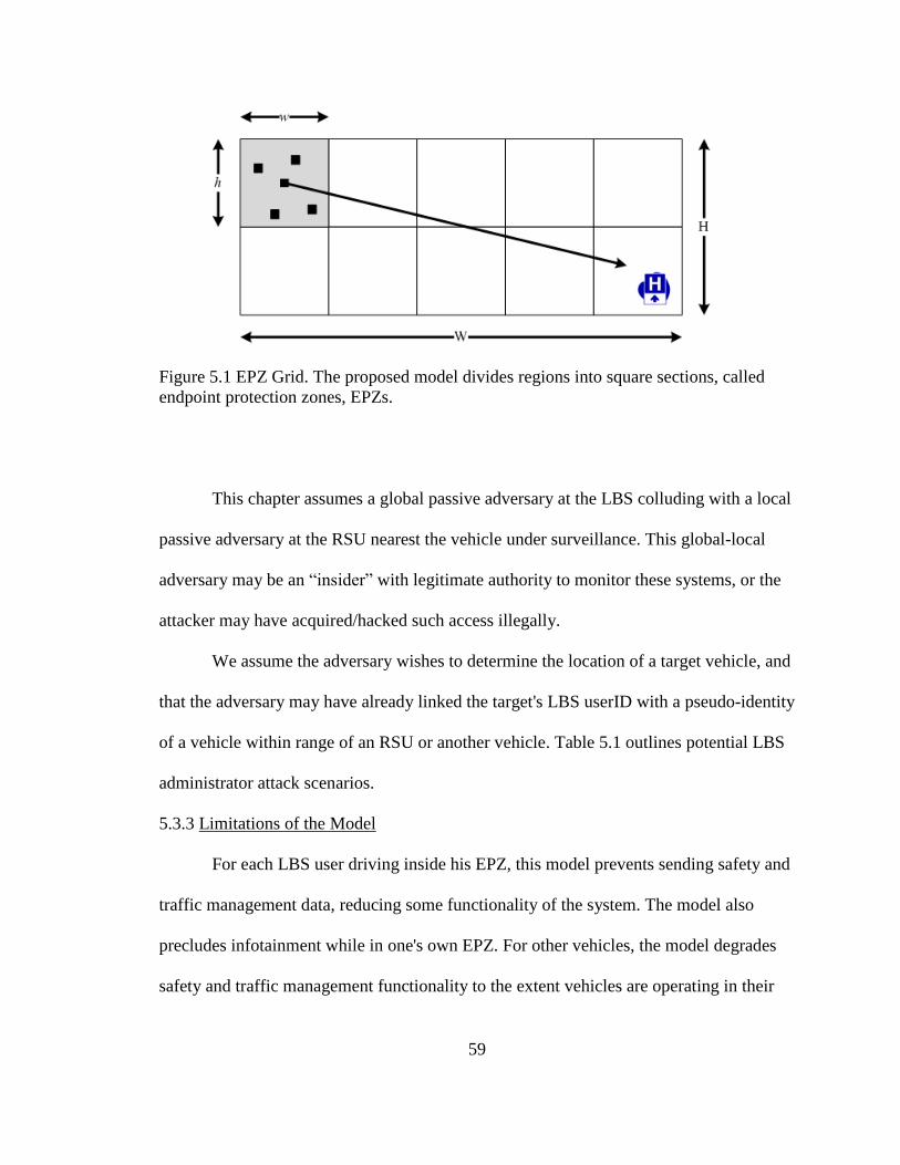
59
Figure 5.1 EPZ Grid. The proposed model divides regions into square sections, called
endpoint protection zones, EPZs.
This chapter assumes a global passive adversary at the LBS colluding with a local
passive adversary at the RSU nearest the vehicle under surveillance. This global-local
adversary may be an “insider” with legitimate authority to monitor these systems, or the
attacker may have acquired/hacked such access illegally.
We assume the adversary wishes to determine the location of a target vehicle, and
that the adversary may have already linked the target's LBS userID with a pseudo-identity
of a vehicle within range of an RSU or another vehicle. Table 5.1 outlines potential LBS
administrator attack scenarios.
5.3.3 Limitations of the Model
For each LBS user driving inside his EPZ, this model prevents sending safety and
traffic management data, reducing some functionality of the system. The model also
precludes infotainment while in one's own EPZ. For other vehicles, the model degrades
safety and traffic management functionality to the extent vehicles are operating in their

60
Table 5.1
Location Privacy Attacks by LBS Administrator
LBS User Action LBS Administrator Attack
Transmit precise home location Identify user with deanonymization*
Obfuscate position with spatial cloaking
Isolate trajectory from snapshots, then
identify user with deanonymization*
Do not transmit to LBS inside EPZ, but
always transmit safety messages
Isolate trajectory from snapshots, then
collude with RSU to correlate paths, then
identify user with deanonymization*
Remain transmission silent within EPZ
Cannot deanonymize*
(no identifiable endpoint)
* LBS administrator uses endpoint (origination or termination) to deanonymize
own EPZ. We envision EPZs to be as small as possible to mitigate these limitations.
Also, not all LBS users will care about privacy. This model protects only those users who
do. The model does not defend against license plate readers, mobile phone monitoring,
roadside cameras, and physical surveillance.
5.4 Metrics
In the VANET security literature, privacy is often equated to anonymity. Even the
IEEE 1609.2 (2013) security standard [4] itself does so, saying, “Anonymity—meaning
the ability of private drivers to maintain a certain amount of privacy—is a core goal of
the system.” A frequently used metric is k-anonymity, though others include l-diversity
[10] t-closeness [11], and ε-differential privacy [12]. This paper confines itself to the

61
concept of k-anonymity, or anonymity set size, defined in the Introduction of this
document. In this paper we measure privacy by anonymity set size, entropy of the
anonymity set size and tracking probability. For a discussion of this topic, see [13].
This study used three metrics, anonymity set size, entropy of anonymity set size
and tracking probability.
5.5 Simulation
To prepare the simulation we used realistic vehicle mobility models and estimated
privacy levels using custom simulation software.
5.5.1 Mobility Patterns
Computer simulations do not always represent vehicle traffic flows accurately.
Harri, et al. [15] suggest that minimum requirements for realistic simulations include
techniques for intersection management, lane changing and car following. Several
systems offer these features, including Generic Mobility Simulation Framework, GMSF
[16]. We used Multi-agent Microscopic Traffic Simulator, MMTS, trace files linked from
the GMSF website [17] and provided at the Laboratory for Software Technology website
[18], specifically City, Urban and Rural. All three models contain records of time-stamps,
vehicle-ids, x-coordinates, y-coordinates within a 3000m x 3000m (9 million square
meters) grid. Each model starts with a different number of vehicles, v. City starts with
v=897. Urban starts with v=488. Rural starts with v=110. Vehicles enter and leave the
system at roughly the same rate, so the number of vehicles in the model at any given time
is not always precisely the same as the number at the start.
Road topologies in some mobility models, such as the Freeway model (a straight
road with perhaps several lanes) and the Manhattan model (a grid of horizontal and

62
vertical roads), vehicle density per linear meter can be out of sync with the vehicle
density per square meter, especially when compared with more realistic road topologies.
For example, for 900 vehicles in a 3000x3000 meter grid, the Freeway model might have
a linear density of 0.3 v/m, 900 vehicles divided by 3000 meters, and a square density of
0.0001 v/m2, 900 vehicles divided by 9 million square meters. The Manhattan model
would have a linear density of 0.004839 v/m, 900 vehicles divided by 186,000 meters,
but the same square density as the Freeway model. In other words, the linear density of
the Manhattan model is 1.6% that of Freeway model given the same square density.
Our simulation does not have this problem because the linear distances covered
by the road topologies are similar: City, 14,783 meters; Urban, 13,955 meters; and Rural,
10,175 meters. The areas covered are identical, so the mobility models we used provide
both realistic traffic flows and comparable coverage distances and areas.
5.5.2 Metrics Computations
We wrote a program which read MMTS mobility model files, city, urban and
rural. Each mobility model has a different vehicle density in the same size region. The
program divided each 3000m x 3000m region into square EPZs, ranging from 300m x
300m (100 EPZs) to 1500m x 1500m (4 EPZs). For each mobility model the program
computed the metrics, |AS|, H(|AS|) and Pt. All simulations covered vehicle movements
over a time period of 2000s, or 33.3 minutes.
5.5.3 Performance Evaluation
The EPZ model was effective only in sufficiently high density areas. When
vehicle density, and therefore LBS user density, was low, and EPZ sizes were small, then

63
anonymity set sizes approached 1.0 and tracking probabilities approached 100%, which
represents the poorest possible privacy protection under our metrics.
Figures 5.2, 5.3 and 5.4 show results when λ=10%. 5.5, 5.6 and 5.7 show results
when λ=20%. Doubling λ doubled |AS| and H(|AS|), but at low densities it more than
halved Pt.
Anonymity set size. Average anonymity set size for the high-density city model
ranged from 5.26 (100 EPZs) to 50 (4 EPZs); for the medium-density urban model, from
4.84 to 30.25; for the low-density rural model, from 1.0 to 1.75. In other words, an
attacker would have roughly a 1/5 to 1/50 chance of identifying the target vehicle in the
city model; a 1/5 to 1/30 chance in the urban model; but a 1/1 to 1/2 chance in the rural
model. Low density settings would require a different method, or EPZs larger in size than
the sizes we tested.
Entropy of the anonymity set size. Average entropy ranged from 2.39 to 5.64 for
city; 2.27 to 4.92 for urban; and 0 to 0.81 for rural. Again, low density settings would
require a different method, or EPZs larger in size than the sizes we tested.
Tracking probability. Average tracking probability ranged from 7% to 0% for the
city model; 7% to 0% for the urban model; and 100% to 14% for the rural model. The
model is of little use in areas of low density given the EPZ sizes we tested.
In practice the model may need to be modified so that the density of LBS users
determines EPZ size, not the other way around. Further experimentation may determine
the optimal breakeven EPZ size given the tradeoff between privacy protection and service
degradation.

64
Figure 5.2: Average anonymity set size by EPZ size, 10% LBS users
Figure 5.3: Entropy of average anonymity set size vs. EPZ size, 10% LBS users
Figure 5.4: Tracking probability vs. EPZ size, 10% LBS users.

65
Figure 5.5: Average anonymity set size vs. EPZ size, 20% LBS users
Figure 5.6: Entropy of average anonymity set size vs. EPZ size, 20% LBS users
Figure 5.7: Tracking probability vs. EPZ size, 20% LBS users

66
In computing the total number of vehicles, V, we ignored vehicles whose
trajectories originated at the edge of the region. Vehicles whose trajectories originated on
the edge were assumed to belong to EPZs located outside of the region. More details and
the program code for this simulation can be obtained from www.vanetprivacy.com.
5.6 Summary
Endpoint protection zones, EPZs, protect vehicle location privacy from
deanonymization. If LBS administrators can correlate origin and destination points with
home and work addresses, they can link identity and location of vehicle owners. This is
not possible if vehicles remain transmission-silent in their respective EPZs.
EPZs protect vehicle location privacy from collusion between LBS administrators
and RSU administrators. Even if LBS administrators can verify with RSUs the locations
of transmissions at their points of origination, they cannot be certain which vehicle from
the EPZ is making the request unless they have additional information beyond the scope
of this study.
The effectiveness of EPZs depends upon density, multiple LBS users originating
from each EPZ. In sparsely populated areas, the EPZ model may be ineffective. One
workaround might be encouraging local friends and family to use LBS. Another
workaround might be to increase EPZ sizes in sparsely populated areas. The practicality
of this is a subject of future study. Perhaps the most important finding of this paper is that
a small increase in LBS users in a sparsely populated area, which may yield only a
proportional effect in anonymity set size, may have a much greater effect on tracking
probability.

67
An interesting property of the EPZ model is that it provides protection even if
only one LBS user from an EPZ is active outside that EPZ. The LBS administrator cannot
know which LBS user is active. This implies that LBS users especially concerned about
privacy could register under multiple false identities, or have friends and family who do
not use the LBS register under real identities. In this way a single person could achieve
k-anonymity > 1.0.
EPZs do not protect against many forms of surveillance, such as license plate
readers, mobile phone monitors, roadside cameras or physical surveillance. However,
against collusion and deanonymization attacks, EPZs may be a useful tool in high density
areas to protect vehicular location privacy.

68
CHAPTER SIX
PRIVACY BY DECOY (PBD)
The weakness of the RRVT model is it only works over short distances and it is
deanonymizable at the RSU level. The weakness of the EPZ model is it only protects
endpoints; if a car is marked in transit it remains vulnerable from the point at which it
was marked until it conceals itself in the terminal EPZ. The next logical advancement in
the protection of location privacy against eavesdroppers is a solution which overcomes
these weaknesses.
This chapter introduces PARROTS, Position Altered Requests Relayed Over
Time and Space, a privacy protocol which protects LBS users' location information from
LBS administrators even (1) when the LBS requires continuous precise location data in a
vehicular ad hoc network, (2) when LBS administrators collude with administrators of
vehicular wireless access points (a.k.a. roadside units, or RSUs), and (3) when precise
location data can be deanonymized using map databases linking vehicle positions with
vehicle owners' home/work addresses and geographic coordinates. Further, this
protection remains in force over greater distances.
The PARROTS protocol is also called Privacy by Decoy (PBD), to distinguish it
from a naïve dummy event model. Recall: A dummy is a fake location sent by the vehicle
desiring location privacy. A decoy is a real location sent by a vehicle other than the
vehicle desiring location privacy.
PBD as described in this chapter is an extension of EPZ. Recall: The analysis of
the EPZ model [27] showed that location based services, LBSs, be designed so that LBS

69
users be grouped by spatial location, into endpoint protection zones, EPZs. Users in the
same EPZ would share login credentials, and remain transmission-silent until outside of
the EPZ, thus preventing an LBS administrator from knowing which particular user from
the EPZ is active—even if the LBS administrator colluded with administrators of
roadside units, RSUs [6]. This section further proposes LBSs be designed so that users
relay dummy/false queries through non user vehicles to camouflage true locations.
Our main contributions are (1) a new way of looking at vehicular location
privacy, called privacy-by-decoy, PBD, (2) a new PBD model, and (3) an examination of
EPZ alone compared to EPZ with PBD. The representative PBD model is called Position
Altered Requests Relayed Over Time and Space, or PARROTS. This model is meant to
apply in vehicular contexts, but it could apply in other contexts as well.
Moreover, unlike any other model of which we are aware, PARROTS functions
even when the defender is inactive. Decoys provide cover by relaying LBS requests even
when the target of an attack turns off her car. To underscore this point, under other
models an attacker perhaps may not locate the target, but at least he will know the target
is active. Under PARROTS, the attacker cannot be sure that an attacker is active even if
he is receiving an active signal because the signal could be coming from a decoy.
Still further, unlike any other model of which we are aware, PARROTS functions
even in locations from which the target could not possibly transmit. Decoys provide
cover by relaying LBS requests perhaps far, far away from the actual location of the
target. To underscore this point, under other models targets transmit their own fake
queries, so an attacker can determine that a too distant decoy message could not possibly
originate from within a certain geographical area. Under PARROTS, the decoy could

70
transmit a request from a location hundreds of miles from the target and the attacker
could not determine if the signal was a fake or if the target just took a long trip.
Besides the EPZ model we are aware of no study to date which has examined the
map deanonymization of endpoints in VANETs under LBS/RSU collusion. This section
extends the prior solution to this problem offered by EPZ.
6.1 VANET System Model
Wireless vehicle-to-vehicle, V2V, communication takes place on an as-needed
basis, as does vehicle-to-infrastructure, V2I, communication. In the latter case, a wireless
access point called a roadside unit, RSU, relays network packets from vehicles to
systems, such as LBSs, connected to the wired infrastructure. Privacy is handled
differently in V2V and V2I communications.
6.2 Threat Model
Attackers can be categorized by the scope of their surveillance capabilities. If the
attacker can observe the entire system of vehicles, this is a global attacker, even though
the scope of the system may only include a single municipality. If the attacker has access
only to a subset of the system, such as the communications range of an RSU, this attacker
is local. Attackers can also be categorized by their intent, passive or active, i.e. whether
they intend merely to monitor targets or whether they also intend to mislead or otherwise
influence targets in some way.
This section assumes a global passive adversary at the LBS colluding with a local
passive adversary at the RSU nearest the vehicle(s) under surveillance. This global-local
adversary may be an “insider” with legitimate authority to monitor these systems, or the
attacker may have acquired/hacked such access illegally. This paper assumes the

71
adversary wishes to determine the location of a target vehicle, and that the adversary may
have already linked the target with a certain pseudo-identity of a vehicle.
6.3 EPZ Equation
The EPZ model [6] divides regions into grids of rectangles of width, w, and
height, h. Let V be the total number of vehicles in a region, R, of area, A. Let λ be the
ratio of LBS users in the same region, so the number of LBS users in R is λV. The
expected anonymity set size for an LBS follows.
E{ ASEPZ } = λVwh/A (6.1)
In the EPZ model all LBS users in an EPZ protect each others’ location privacy
by using the same group login credentials. This is enforced by the LBS when the user
registers with the service; the EPZ is calculated at the point of registration after which the
location information is discarded.
6.4 PARROTS Protocol
The EPZ Model can be enhanced by using decoys. Consider a regime in which
helper vehicles, called parrots, relay LBS requests on behalf of an LBS user in a vehicle
desiring privacy, called a pirate. The pirate would transmit LBS requests normally.
Parrots would transmit LBS requests on behalf of the pirate, using the pirate's login
credentials but the parrots' locations. Parrots' locations could not be identified as fakes
because they are real locations in real current traffic conditions. Parrots could mimic
pirates over great temporal and spatial range.
In order for this scheme to work LBS systems must permit login credentials to be
sent encrypted, but vehicle locations unencrypted. After all, if the LBS users' credentials
are not encrypted a malicious parrot could misuse the pirate's credentials. And if the
72
location is encrypted the parrot would not be able to perform the encryption since the
parrot would not possess the pirate's private key.
Under this system there is no leakage of any information from the pirate to the
parrot save the destination address of the LBS. Encryption prevents parrots from reading
pirate's login information, query information or responses from LBSs since LBSs encrypt
replies with the pirates' public keys.
Under this system the LBS cannot determine which vehicles are pirates and which
are parrots. The login credentials are authentic, and the locations are real. Location
privacy is achieved by k anonymity if a pirate has k-1 parrots. If LBSs permit group
logins then even greater anonymity is accomplished.
By relaying each others' dummy queries, vehicles can protect each other from
surveillance by LBS administrators – even if those administrators collude with
administrators of other system infrastructure components such as RSUs. This protection
can be accomplished if LBS software accepts authorizations using encrypted group
userIDs, passwords and service requests, along with unencrypted locations.
In a traditional online system, such as Foursquare, used at a desktop or laptop
computer or on a smart phone, a user may log in manually with a userID and password.
Then, either the user may manually enter a location query, or the application may infer
the location from contextual information such as the IP address or GPS information of the
client computer. Using group signatures, authorization could be accomplished on a group
basis. A traditional service permits users to log in from any computer. A secure session,
such as occurs under HTTPS, would be authenticated using SSL certificates of the

73
computers, not of the LBS userIDs. So it is possible to allow multiple secure logins of
LBS users. Anonymity sets may be formed as in Figure 6.1.
The PARROTS protocol suggests that LBSs should operate like traditional
services, except the login information should be enclosed in an encrypted message, and
the location information should be unencrypted. A vehicle which wishes to be parroted,
i.e. a pirate, would send an encrypted LBS authentication message to a vehicle which is
willing to relay the decoy messages, i.e. a parrot. The parrot would relay to the LBS the
pirate's encrypted message appended with the parrot's location. The pirate would send to
the LBS the pirate's encrypted message appended with the pirate's location. The result is
1 23 4 5
VjVi
LBS Group L
(Application Layer)
RSU-BRSU-ALBS
Dummy QueryReal Query
|AS| = 2|AS| = 8
DSRC Group GL1
(Network Layer)
6 7 8
|AS| = 3
GL2
GL1DSRC Group GL2
(Network Layer)
Figure 6.1: LBS Anonymity Sets. LBS users form groups to protect themselves from
potentially snooping LBS administrators. Individual LBS users may communicate with
other vehicles which agree to relay the LBS user's dummy queries, increasing the
anonymity set size, |AS|, of the entire LBS group.

74
that the LBS administrator does not know which location is the location of the pirate –
even if he can verify through IP traceback which vehicle is the source of each message.
Figure 6.2 shows how vehicle Vj could be contacted by vehicle Vi while in
communication range. Vj would send no genuine queries of its own to the LBS, but rather
it would send fake queries on behalf of Vi. Normally, the LBS would think Vi's request
was from one of the members of LBS Group L, but in reality one query is coming from
Vj, posing as a member of LBS Group L. If the LBS administrator performs an IP
traceback to RSU B, he will confirm the vehicle sending the transmission is in fact at the
location queried, [X(Vj), Y(Vj)]. So, with parroting, the anonymity set size increases by 1
for every member of Group L. This is shown in Figure 6.1.
RSU-A
ID X Y
-- ------ ------
GL1 X(GL1) Y(GL1)
GL1 X(Vi) Y(Vi)
RSU-B
ID X Y
-- ------ ------
GL2 X(GL2) Y(GL2)
GL2 X(Vj) Y(Vj)
GL2 X(3) Y(3)
GL2 ... ...
LBS
ID X Y
-- ------ ------
L X(Vi) Y(Vi)
L X(1) Y(1)
L Y(2) Y(2)
L X(Vj) Y(Vj)
Figure 6.2: LBS-RSU Collusion. The reports above provide the information available to
administrators of RSU-A, LBS and RSU-B, respectively. Notice that the |AS| of group L
rises from 3 to 4 because of Vj, even though Vj is not part of LBS. If LBS administrator
performs IP traceback, he finds query originated from the location queried.

75
6.4.1 Definitions and Assumptions
PARROTS depends on PKI. Each party in a secure communication has a public
and private key. Define CA as the certificate authority which issues identities and
certificates, including pseudo identities, or pseudoIDs, for vehicles. Let Vi indicate a
vehicle with pseudoID i. Let Vj indicate a vehicle with pseudoID j. Assume pseudoIDs
are valid for short periods of time, say five to ten minutes.
Let RSU refer to a roadside unit, a wireless access point for vehicles to connect to
the wired infrastructure. Let LBS indicate a location based service. Let POI mean "point
of interest," such as a restaurant or gas station. Let "request" be defined as a message
asking for information, such that an LBS request would be a message asking for
information from the LBS. Let Ui indicate the identity of LBS user in Vehicle i. Assume
Ui is an email address, so it can have an associated public key, indicated by a trailing plus
sign, Ui+. Define Cert(Ui) as the digital certificate binding Ui's email address and public
key such that Cert(Ui) = CA-(Ui, Ui
+).
Let "pirate" be defined as the vehicle of an LBS user who wishes to be mimicked.
Let "parrot" be defined as a vehicle, not necessarily linked to any LBS user, willing to
mimic the pirate. If Vi wishes to be mimicked, then Vi would be a pirate. If Vj is willing to
mimic Vi , then Vj would be a parrot.
Assume LBS users have userID/password combinations which do not expire as
quickly as vehicular pseudoIDs and temporary MAC addresses. Further assume LBS
users may log in to the LBS from any computer/vehicle.

76
6.4.2 PARROTS Equations
The PARROTS model depends on EPZs. Recall equation (6.1). Now let ρ be the
ratio of potential parrots, so the number of potential parrots in R is ρV. Note that the set of
LBS users and the set of potential parrots are disjoint sets. Now let φ be the ratio of LBS
users who desire privacy. Note if all LBS users desired privacy, φ=1. The expected
anonymity set size for an LBS user under the EPZ model with PARROTS if the LBS
enforces single-user login is as follows.
E{ ASEPZ-pi } = 1 + ρ / φ λ (6.2)
The expected anonymity set size for an LBS user under the EPZ model with
PARROTS, if the LBS allows group logins, is as follows.
E{ ASEPZ-pg } = (λ + ρ) wh/A (6.3)
6.5 Simulation
A simulation system was written using realistic vehicle mobility models
conforming to standards in [22] which suggest that minimum requirements for realistic
simulations include techniques for intersection management, lane changing and car
following. Several systems offer these features, including Generic Mobility Simulation
Framework, GMSF [23], the website for which offers Multi-agent Microscopic Traffic
Simulator, MMTS, trace files linked from the GMSF website [24] and provided at the
Laboratory for Software Technology website [25], specifically City, Urban and Rural. All
three models contain records of time stamps, vehicle ids, x-coordinates, y-coordinates
within a 3000x3000 meters (9 million square meters) grid.
Each model starts with a different number of vehicles, v. City starts with v=897.
Urban starts with v=488. Rural starts with v=110. Vehicles enter and leave the system at
77
roughly the same rate, so the number of vehicles in the model at any given time is not
always precisely the same as the number at the start.
Road topologies in some mobility models, such as the Freeway model (a straight
road with perhaps several lanes) and the Manhattan model (a grid of horizontal and
vertical roads), suffer from vehicle density challenges. Vehicle density per linear meter
can be out of sync with the vehicle density per square meter, especially when compared
with more realistic road topologies. For example, for 900 vehicles in a 3000x3000 meter
grid, the Freeway model might have a linear density of 0.3 v/m, 900 vehicles divided by
3000 meters, and a square density of 0.0001 v/m2, 900 vehicles divided by 9 million
square meters. The Manhattan model would have a linear density of 0.004839 v/m, 900
vehicles divided by 186,000 meters, but the same square density as the Freeway model.
In other words, the linear density of the Manhattan model is 1.6% that of Freeway model
given the same square density. The simulation upon which this paper is based does not
suffer nearly as severely from this problem because the linear distances covered by the
road topologies are similar: City, 14,783 meters; Urban, 13,955 meters; and Rural, 10,175
meters. The areas covered are identical, so the mobility models provide both realistic
traffic flows and comparable coverage distances and areas.
The simulation software read the mobility model file and for each mobility model
and computed the traditional metrics, ASi, Hi and Pti,. All simulations covered a time of
2000s, or 33.3 minutes. The software divided a 3000m x 3000m region into square EPZs,
ranging from 1500m x 1500m (4 EPZs) to 300m x 300m (100 EPZs). 6.6 Analysis
Figure 6.2 summarizes the results of the simulation. It compares ASi, Hi and Pti
for two models: EPZ alone and EPZ with PARROTS, group login. The software

78
simulated using 10% LBS users (λ=0.10) and 10% potential parrots (ρ=0.10 and φ=1.00).
In computing V, the software ignored vehicles whose trajectories originated at the edge
of the region. Vehicles whose trajectories originated on the edge were assumed to belong
to EPZs located outside of the region.
6.6.1 EPZ Alone
Simulation showed that the EPZ model is effective to the extent that multiple LBS
users have endpoints in EPZs. When vehicle density, and therefore LBS user density, is
low, and EPZ sizes are small, then anonymity set sizes approach 1 and tracking
probabilities approach 100%, which represents the poorest possible privacy protection
under the privacy metrics. EPZ works, but only with sufficient vehicle and LBS user
densities.
6.6.2 EPZ with PARROTS, Group Login
The PARROTS model with group login performed best in tests. The effect of EPZ
with group login, combined with PARROTS, produced anonymity set sizes close to the
theoretical value, and showed visible improvement in tracking probabilities.
6.6.3 EPZ with PARROTS, Individual Login
The PARROTS model with individual login performed worse than the EPZ model
alone, except in low density situations PARROTS demonstrated equivalent results. The
reason for this is because PARROTS’ performance depends not on the density of LBS
users but on the ratio of potential parrots to pirates. In all cases, regardless of vehicle
density, anonymity set size was near 2, the theoretical value.
79
6.7 Summary
This chapter presented the concept of relayed dummy events as a privacy defense
in FPLQ conditions in a VANET system under DSRC/WAVE. EPZ requires no
additional network transmissions to establish privacy levels, so there is no bandwidth
tradeoff for implementation. PARROTS requires a recruitment phase and multiple
duplicate transmissions by parroting vehicles. This study measured the privacy
performance, not the network efficiency, of the models. In future work we hope to run
simulations to determine an optimal balance.
The EPZ and PARROTS protocols address conditions, (1) when the LBS requires
continuous precise location data in a vehicular ad hoc network, (2) when the LBS
administrator colludes with administrators of vehicular wireless access points (a.k.a.
roadside units, or RSUs), and (3) when precise location data can be deanonymized using
map databases linking vehicle positions with vehicle owners' home/work addresses and
geographic coordinates. Simulations using realistic vehicle traffic mobility models
showed PARROTS increased average privacy levels in high vehicle density conditions
when deployed in combination with EPZs, and increased them even more effectively in
low vehicle density conditions.
Neither PARROTS nor EPZs protect against many forms of surveillance, such as
license plate readers, mobile phone monitors, roadside cameras or physical surveillance.
However, against collusion and deanonymization attacks EPZs may be a useful tool to
protect vehicular location privacy. PARROTS enhances the effectiveness of EPZs. Other
vehicle location privacy methods which use decoys for protection would transmit dummy
events while the real LBS querier is active. The PARROTS model is unusual in that

80
parrots can make requests of an LBS on behalf of pirates even when pirates are inactive.
Under the specific conditions presented in this paper, it has the further benefit of enabling
undetectable decoys over a spatial range broader than the communications range of the
LBS querier. See Figure 6.3, parts (a) through (f), for graphical representation of results.
(a)
(b)
Figure 6.3: Comparison of EPZ and PBD Models. (a) EPZ alone, anonymity set size, (b)
EPZ with PARROTS, group login, anonymity set size

81
(c)
(d)
Figure 6.3: Continued… (c) EPZ alone, entropy of anonymity set size, (d) EPZ with
PARROTS, group login, entropy of anonymity set size

82
(e)
(f)
Figure 6.3: Continued… (e) EPZ alone, tracking probability, (f) EPZ with PARROTS,
group login, tracking probability
83
CHAPTER SEVEN
SAFETY-SILENCE TRADEOFF EQUATION (SSTE)
Automobiles and other vehicles will soon include network equipment, effectively
turning roadways into moving communication systems. One of the primary objectives of
such systems is safety. As has been discussed above, in future VANETs BSMs would be
transmitted by all vehicles every 100ms in order to help prevent inter-vehicle crashes. At
first not all vehicles would contain the hardware and software necessary to transmit
BSMs; there would be an interval when only a percentage of vehicles would transmit.
Further, even after all vehicles install the equipment, some privacy researchers
recommend silent periods, spans of time during which vehicles deliberately cease
transmissions.
Whether due to lack of equipment or due to privacy protocols, silent periods
would defeat safety provided by BSMs. This chapter quantifies this tradeoff, presenting
the Safety-Silence Tradeoff Equation, and showing an inverse exponential relationship
between the proportion of vehicles transmitting BSMs and the proportion of potential
collisions between vehicles unprotected by BSMs.
VANET equipment is expected to take time to roll out. To prevent a crash
between two cars, the equipment must be operational in both cars. To obtain full safety
value from a VANET requires equipment to be operational in all cars. It will take time to
achieve near-full implementation. To our knowledge no study has been done to compute
the cost of delaying such a rollout.

84
Further, VANETs raise privacy concerns because they would transmit data which
may also be used for unwanted surveillance. Researchers have proposed protocols to
protect against surveillance, but many protocols require periodic silent periods, spans of
time when vehicles cease transmissions, thereby disabling VANET safety benefits. To
our knowledge no study has been done to compute the cost of implementing these silent
periods.
The privacy issue is not moot because of E911. It is possible for motorists to
confuse traffic monitors using DSRC even if the devices or trade them with other people.
However, US DOT by requiring DSRC in vehicles may not allow drivers to turn systems
off except for specific privacy purposes for which provisions have been made in IEEE
1609.2. Moreover, the Principle of Least Privilege remains a well-respected, fundamental
and enforceable information security policy. It dictates that privacy defenders cannot fail
to protect location data from one attacker simply because another potential attacker has
access. Transportation monitors would work on DSRC systems completely independently
from E911 system. Transportation monitors should only be given access to such data if it
is deemed important by whoever sets up the transportation system. The same would be
true for LBSs such as Waze. If LBS executives were to allow its administrators to
casually monitor drivers, the company may be exposed to legal risks. Plus, there may be a
moral issue, or even a business perception issue.
This research addresses the following problem: the tradeoff between safety and
silence. The safety-silence tradeoff problem is important because society values both
safety and privacy. Without a quantitative measure for the tradeoff it is difficult for
individuals and policymakers to weigh necessary compromises between the two.

85
The problem is complicated because VANETs do not work exactly like
conventional networks. First, the networks are in motion, following mobility patterns of
cars and trucks. Second, the protocols differ. Corporate and home networks, for example,
depend on static MAC addresses and TCP/IP, but safety systems in VANETs use new
protocols in which MAC addresses are dynamic—they can be changed by the vehicle in
transit. In the United Stated the new protocols are part of Dedicated Short Range
Communications (DSRC) / Wireless Access in Vehicular Environments (DSRC/WAVE).
WAVE Short Message Protocol (WSMP) was created to improve communication speed.
Dynamic MAC addressing was added specifically to enable privacy protocols. The BSM
for example is part of a protocol called SAE J2735.
The primary contribution of this section is the presentation and proof of the
Safety-Silence Tradeoff Equation. Also presented are illustrations and examples of
applications of the equation. To our knowledge no method has yet been proposed to
compute this tradeoff in vehicular contexts. There are some works on the mathematics of
privacy [15] and computational privacy [14], but they do not include discussions of the
cost tradeoff between safety and silent periods.
The rest of this chapter is organized as follows. Section 7.1 presents background
for the VANET privacy problem, establishing the necessity of silent periods. Section 7.2
presents mathematical analysis and proof. Section 7.3 presents an illustration and Section
7.4 discusses practical considerations. Section 7.5 presents results of simulations to
evaluate performance of the equation. Section 7.6 concludes the chapter.

86
7.1 Silent Periods
VANETs depend on vehicles each having access to accurate Global Positioning
System data. Vehicles transmit their positions to each other using vehicle-to-vehicle
(V2V) communications. Vehicles may communicate with application servers, such as
Location Based Services (LBS) via wired roadside units (RSU) using vehicle-to-
infrastructure (V2I) communications. However, as far as their effect on safety is
concerned in this chapter, silent periods are relevant only within V2V communications.
Among the earliest and most cited papers [1] in the field of vehicular ad hoc
network privacy are recommendations that privacy protection schemes include silent
periods. Recent work has suggested privacy protocols be executed at “social spots” such
as traffic lights and intersections [16].
These and other recommendations were founded partly on the results of seminal
work in mix zones [2]. Silent periods and mix zones operate together. Vehicles cease
transmitting and change positions, then begin transmitting again using different
identifiers. Silent periods and mix zones have been proven to be effective, and some even
suggest in cases where one mix zone is not enough, use multiple cascading mix zones for
even more privacy protection [3]. The problem of silent periods and mix zones has been
studied for at least the past ten years [6-12].
If the US Department of Transportation mandates the implementation of
VANETs, as they are expected to do, not all vehicles will transmit basic safety messages
(BSMs). At some point in time, at a given intersection or other potential collision point,
perhaps only half of the vehicles will have VANET equipment installed. Even after full

87
deployment vehicles will go radio silent when implementing privacy protocols. What’s
the risk?
7.2 Mathematical Analysis
The probability of a crash between vehicles can be estimated by examining the number of
possible crash combinations in a given geographical area during a given time frame.
Assuming the probability of a crash is different when vehicles are not transmitting BSMs,
then given certain assumptions, the probability of at least one crash in a region R during a
time ∆t is as follows. This is the Safety-Silence Tradeoff Equation. Note: This assumes
that the probability is negligible (zero) for a crash between three vehicles. The rationale
behind this assumption is that a three-car crash occurs when a third car crashes into a two
other cars, not when three cars crash into each other at the same time.
(7.1)
Proof. Let pb be the probability of a crash between two vehicles both transmitting
BSMs. By the Complement Rule the probability of any particular two such vehicles not
crashing is (1 – pb).
By definition of combination, the total number of potential crashes between any
two of n vehicles is . Therefore the number of potential crashes between any two of b
vehicles is , where b is the number of vehicles in R transmitting BSMs during ∆t.
By the Multiplication Rule the probability of all b vehicles not crashing is the
product of the probabilities of each potential crash not occurring, i.e.
.

88
Define n as the total number of pairs in R during ∆t. Then the total number of
pairs is . The number of possible crashes of unprotected vehicles, vehicle pairs where
at least one of the vehicles is not transmitting BSMs, is , and
.
This is true because if only one vehicle is transmitting BSMs then the probability
of a crash is the same as if neither vehicle were transmitting BSMs. BSMs only work if
both vehicles transmit. This analysis assumes that if vehicles have OBUs they transit
BSMs, otherwise they do not. With privacy protocols operating on OBUs there are
actually four possibilities, (a) both transmitting, (b) both not transmitting, (c) receiving
vehicle is not transmitting but other vehicle is transmitting, and (d) receiving vehicle is
transmitting but other vehicle is not transmitting. The four-possibility scenario is not
considered here however the presentation is easily extendable to more scenarios.
The probability of three vehicles crashing would be the probability of one pair
crashing multiplied by the probability of another pair crashing in the same region R
during the same time, ∆t. Since probabilities, pb and pu, are extremely small, it can be
assumed that the probability of three cars crashing is negligible. That is, , ,
and .
The probability of at least one crash, , is
, which reduces to (7.1). QED.
7.3 Illustration
Figure 7.1 shows that the maximum number of possible collision combinations
rises exponentially with the number of vehicles. If we choose n=10 we can vary b to see

89
Figure 7.1: Maximum possible collision combinations. Maximum rises exponentially
with the number of vehicles present at the intersection.
the relationship between b, the number of vehicles transmitting BSMs, and n, the total
number of vehicles in region R.
Figure 7.2 shows that if 5 of 10 (50%) vehicles transmit BSMs, 35 out of 45
(78%) collisions remain possible. One could conclude that if a large percentage of
vehicles would enter a silent period, then neighboring vehicles might do likewise since
the marginal loss in collision protection would be at a minimum.
7.4 Practical Considerations
With four vehicles at a four-way stop, there are 28 possible impact points but
=6 possible collisions between two vehicles. See Figure 7.1 The equation does not
count the number of potential impact points, rather, it counts only the number of
combinations of pairs of vehicles.

90
Figure 7.2: Relationship between BSMs and potential collisions. An inverse exponential
relationship exists between the proportion of vehicles transmitting BSMs and the
proportion of potential collisions unprotected by BSMs. Under assumptions, if 5 of 10
(50%) vehicles transmit BSMs, 35 out of 45 (78%) collisions remain possible.
The safety-silence tradeoff equation predicts the probability of at least one
collision is 1 - (1 - pb) (1 - pu)5 where pb and pu are as defined in Section 7.2 and assume
n=4 and b=2.
With six vehicles, an intersection of one two-lane road and one four-lane road,
there are 56 possible impact points assuming expected traffic flow. Three possibilities are
ruled out in the model: A cannot collide with E, C cannot collide with F, and E cannot
collide with F. Therefore, there are - 3 = 12 possible collisions between two vehicles.
Suppose A, B and C do not transmit BSMs, but D, E, and F do. Then
and
.
In sum, impossible collision combinations must be subtracted from the exponent in the
safety-silence tradeoff equation. This can be accomplished by including constants. Let

91
the quantities, cb and cn, be the number of logistically impossible collision combinations
between vehicles both transmitting BSMs and between all vehicles, respectively. Then
the modified equation would be as follows.
(2)
7.5 Simulations
Results were compared for two types of intersections, Class 1 and Class 2, as
pictured in Figure 7.3 and Figure 7.4, respectively. All possible values for b and n were
computed and simulated. No combinations were removed using constants as in (2); all
computations were pure, as in (1).
Probabilities and other simulation parameters were set according to Table 7.1.
There were 1000 simulation runs per scenario.
Comparison of computed versus simulated results showed that the equation
estimated simulation results accurately. However, as probabilities become increasingly
small computations become less accurate. Numerical methods will need to be employed
in order to maintain numerical precision.
Figure 7.5 shows the results for Class 1 intersection simulations with probability
scenarios A, B and C as defined in Table 7.1. Figure 7.6 shows results from Class 2
intersection simulations. Figure 7.5 and Figure 7.6 echo a pattern similar to that shown in
Figure 7.1, except the reduction in the probability of at least one crash occurs even more
gradually with the increase in the ratio of the number of vehicles transmitting BSMs to
the total number of vehicles in the system.

92
Figure 7.3 Four vehicles at an intersection of two two-lane roads

93
Figure 7.4: Six vehicles at an intersection of a two-lane and a four-lane road. Class 2
simulation scenario.

94
Table 7.1
Safety-Silence Tradeoff Simulation Parameters
Parameters Values
Intersections, vehicle
quantities (n) and vehicles
sending BSMs (b)
Class 1: n=4 vehicles at an intersection of two two-lane
roads, 0 ≤ b ≤ 4
Class 2: n=6 vehicles at an intersection of a two-lane and a
four-lane road, 0 ≤ b ≤ 6
pb, pu Scenario A: pb=.1, pu =.2
Scenario B: pb=.01, pu =.02
Scenario C: pb=.001, pu=.002
Figure 7.5 Intersection Class 1, probability scenarios A, B and C

95
Figure 7.6: Intersection Class 2, probability scenarios A, B and C
96
The figures assume intersections are full, i.e. all possible positions of vehicle in an
intersection have a vehicle present and waiting to enter the intersection. It may be more
likely that one or more possible positions are unfilled. Consider the diagram in Figure
7.3. It may be that positions A, B and C are occupied, but D is vacant; there is no car at
position D. In this case all vehicle combinations involving D cannot produce crashes. A
simulation was run using a Class 1 intersection under Scenario A as defined in Table 7.1.
Simulations were run using extremely high probabilities because simulations
using probabilities in the realistic range would not hold numerical precision. However,
computed and simulated results showed clearly similar patterns. If these patterns hold in
smaller probabilities then the Safety-Silence Tradeoff Equation may serve as a useful
back-of-the-napkin estimator. For a perpective using a broad set of vehicle densities, see
Figure 7.7.
About 40% of all accidents in the US occurred at intersections in 2006, 8,500 of
which were fatal and 900,000 of which were injurious [17]. In Japan, in 1997, 60% of
accidents occur at intersections. Based on a study of 150 four-legged intersections in the
Tokyo metropolitan area, researchers observed that the average probability of a vehicle
encountering an obstacle vehicle was 0.339 and the average probability of a following
vehicle driver’s failure was 0.0000002 [18]. These vehicles were not outfitted with on-
board units (OBUs), the devices that transmit BSMs. No data are available regarding
accident probabilities of vehicles with OBUs installed, however one recent NHTSA
report estimated that V2V could one day address 79% of vehicle crashes [19]. From this
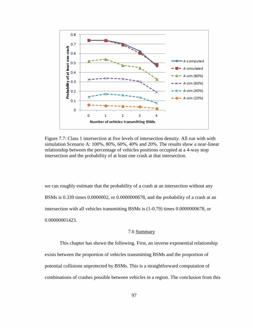
97
Figure 7.7: Class 1 intersection at five levels of intersection density. All run with with
simulation Scenario A: 100%, 80%, 60%, 40% and 20%. The results show a near-linear
relationship between the percentage of vehicles positions occupied at a 4-way stop
intersection and the probability of at least one crash at that intersection.
we can roughly estimate that the probability of a crash at an intersection without any
BSMs is 0.339 times 0.0000002, or 0.0000000678, and the probability of a crash at an
intersection with all vehicles transmitting BSMs is (1-0.79) times 0.0000000678, or
0.00000001423.
7.6 Summary
This chapter has shown the following. First, an inverse exponential relationship
exists between the proportion of vehicles transmitting BSMs and the proportion of
potential collisions unprotected by BSMs. This is a straightforward computation of
combinations of crashes possible between vehicles in a region. The conclusion from this

98
observation is, if privacy protocols must include a silent period, then perhaps as many
vehicles as possible should execute privacy protocols when any vehicles decide to go
transmission silent. This is because the marginal loss in collision protection is greatest
when one single vehicle decides not to transmit BSMs while all others do.
Second, the Safety-Silence Tradeoff Equation can estimate the cost of VANET
privacy methods that require silent periods. This can be done by computing the likelihood
of crashes between combinations of vehicles at intersections. In order to accomplish this
in practice, future work would necessarily include gathering statistics to obtain accurate
probabilities in different intersection situations and developing numerical techniques to
maintain computational precision when applying the probabilities, pb and pu. The specific
probabilities, pb and pu, will likely differ given a range of factors including location,
weather conditions, and the types of vehicles in the region.
Third, in practice some combinations of potential collisions might be eliminated.
The equation can be modified to accommodate these scenarios by the inclusion of certain
constants. Careful analysis of historical vehicle crash data would be required in order to
accomplish this in practice. There may even be a need to develop a handbook or other
database for crash probabilities between vehicles at different types of intersections,
including which combinations can be ignored.
Fourth, traffic density affects the computation. If intersections are not full of cars,
probabilities of crashes are lower. Sophisticated traffic management systems of the
future, armed with hyper-accurate historical data of past crashes, and vehicle densities,
might be able to inform vehicles seeking privacy using silent periods of the optimal
(safest) times and locations to execute the protocols.

99
Finally, transmission silence could occur because the dissemination of on-board
units (OBUs) has not reached a high level of saturation in a particular geographical area.
During this ramp-up interval the use of privacy protocols which require silent periods
would be less risky than in intervals or locations of full saturation.

100
CHAPTER EIGHT
EVALUATING PROTOCOLS USING KDT
Privacy protocols have to date generally measured privacy performance based on
metrics such as k-anonymity. Because of the frequency and precision of location of
queries in vehicular applications, privacy measurement may be improved by considering
additional factors. As it is described in Chapter Three, this applies KDT anonymity, a
composite metric including average anonymity set size, K, average distance deviation, D,
and anonymity duration, T. This section evaluates five privacy protocols under realistic
vehicle mobility patterns using KDT anonymity, and compares KDT anonymity with
prior metrics.
The simulation set-up is summarized in Table 8.1. In each simulation, the goal
was to achieve anonymous FPL LBS access, maximizing KDT. That is, vehicles
attempted to anonymize with as many other vehicles as possible, remaining anonymous
for as great a distance as possible, and for as long a time as possible. Each vehicle did the
following.
1. Enter region, deanonymized.
2. Execute privacy protocol, become anonymized.
3. Exit region and become deanonymized again, or otherwise terminate
anonymous LBS access.
The rationale behind the anonymization process outlined above is to create a
controlled environment to compare protocols. One could imagine entering a large region
where there are only a few means of ingress and egress, with each ingress/egress point

101
Table 8.1
KDT Simulation Parameters
Parameter Setting
Size of region, R 3000 m x 3000 m
Communications Range 200m, 300 m, or 400m
Mobility Models GMSF (City, Urban, Rural) [23]
Mix Points 50, 60, 70, …, 150, or continuous
Silent Period (∆t) 30 seconds
Simulation Time 2000 s (33.3 min)
Avg. Vehicle Speed 20 m/s
monitored by LPRs. If a motorist desired to move about the interior of region
anonymously she would have to anonymize after the point of ingress and would lose
anonymity upon egress.
8.1 Threat Model
Intelligent Transportation Systems (ITSs) are expected to one day include air-
traffic-control-like LBS systems called Traffic Management Systems (TMSs) which
would enable traffic managers to guide drivers or driverless cars based on current vehicle
traffic conditions. If US DOT decides to mandate the use of TMSs, and if vehicles access
TMSs through WSMP, then a malicious insider or an outsider who has hacked a TMS
might be able to track vehicles from the comfort and anonymity of her own home laptop.
This chapter analyzes privacy protocols using the threat modeling framework
proposed in [7], which defines the means, actions and goals of the potential attacker. This

102
paper assumes a global passive adversary (GPA) with the following means: access to
LBS application data, RSU data and perhaps to certain license plate reader (LPR) or other
camera data; and knowledge of geography (road maps / road topology), traffic conditions
(blocked / slow roads), home owner names and addresses and geographical coordinates,
and the target’s name, address, license plate number, and perhaps expected mobility
profile. This paper considers DSRC communications only, not cell phone data or other
information from other devices even though that might also be useful to an attacker.
The GPA’s actions are assumed to be passive; that is, the GPA would eavesdrop
only and would not alter the data being transmitted. The scope of the attack would be
global; that is, the GPA could observe data over a wide region, the entire area covered by
the TMS. The temporal scope of the actions may be long term; that is, the GPA could
eavesdrop for hours, days, months, or even longer periods of time.
The goal of the GPA would be to determine whether a specific vehicle (target)
was at a given place at a given time in order to track the target in real time.
8.2 Mobility Patterns
This research employed Generic Mobility Simulation Framework, GMSF [21],
which offers Multi-agent Microscopic Traffic Simulator, MMTS, trace files linked on the
GMSF website [22] and provided at the Laboratory for Software Technology website
[23], specifically city, urban and rural. All three trace files contain records of
time-stamps, vehicle-ids, x-coordinates, y-coordinates within a 3000x3000 meter (9
million square meter) grid. Each mobility pattern starts with a different number of
vehicles, v. City starts with v=897. Urban starts with v=488. Rural starts with v=110.

103
Vehicles enter and leave the region at the same rate, but the number of vehicles in the
pattern at any given time is not always precisely the same as the number at the start.
Sometimes road topologies, such as in the Freeway pattern (a straight road with
perhaps several lanes) and the Manhattan pattern (a grid of horizontal and vertical roads),
provide wide ranging linear density versus area density. That is, the vehicle density per
linear meter can be out of sync with the vehicle density per square meter, especially when
compared with more realistic road topologies. For example, for 900 vehicles in a 3000 m
x 3000 m grid, the Freeway pattern might have a linear density of 0.3 v/m, 900 vehicles
divided by 3000 meters, and a square density of 0.0001 v/m2, 900 vehicles divided by 9
million square meters. The Manhattan pattern would have a linear density of 0.004839
v/m, 900 vehicles divided by 186,000 meters, but the same square density as the Freeway
pattern. In other words, the linear density of the Manhattan pattern is 1.6% that of
Freeway pattern given the same square density.
The mobility patterns used in this simulation, however, have similar linear
distances: city, 14,783 meters; urban, 13,955 meters; and rural, 10,175 meters. The areas
covered are identical, 3000 m x 3000 m, so the mobility patterns provide relatively
realistic traffic flows and comparable roadway linear distances and square areas.
8.3 Location Privacy Protocols and Mix Points
To create mix zones, as defined in [24], simulations used the concept of a mix
point, a position in space and time, with coordinates (x,y,t). The mix point was used to
create a circular mix zone of radius, r. If a vehicle was positioned within r, i.e. within
comrange, of (x,y) at time t, then that vehicle initiated whatever the privacy protocol
required. If the vehicle never came within comrange of any mix point then the vehicle
104
never became anonymized. This simulation tested five protocols: SMP-R, stationary mix
points, occurring at regular time intervals; SMP-I, stationary mix points, occurring at
irregular time intervals; OTFP-R, randomly chosen on-the-fly mix points, occurring at
regular time intervals; OTFP-I, randomly chosen mix points, occurring at irregular time
intervals; and GLRP-2, group leader relay points, which occur continuously throughout
the trajectory of a vehicle designated as the leader of a group of vehicles traveling within
comrange of the leader. The number, 2, in GLRP-2 indicates that vehicles join the group
in pairs. Performance was evaluated against the theoretical values computed in Section 3.
This section provides descriptions of each protocol.
8.3.1 Stationary Mix Point (SMP)
An SMP creates a region that does not move in which vehicles may switch
pseudoIDs. A similar protocol is described in [55], but in the SMP model presented here,
a fixed point (x, y) was chosen. To maximize k, the busiest intersection in the mobility
model was chosen as the “social spot” for mixing. In scenario SMP-R, regular time
intervals were chosen. In scenario SMP-I, irregular time intervals were chosen. Vehicles
that were within radius, r, of point (x, y) at time, t, were added to the anonymity set.
Upon anonymizing, vehicles enter a silent period. They cease all communications
at both MAC and APP layers because, if they were to continue communications via one,
under RSU LBS collusion they would be linkable to the other. All vehicles in the
anonymity set changed pseudoIDs, but remained silent until the silent period expired, at
which point all silent vehicles resumed communications, including anonymous LBS
access, using new identifiers. See Figures 8.1 and 8.2.

105
r
A B
A-new
B-new
silent silent
C-new
C
silent
Figure 8.1: Stationary mix point (SMP) VANET privacy protocol. The circular mix zone
does not move. At regular, predetermined points in time, a beacon announces it is time to
mix. Vehicles in comrange cease transmissions, switch pseudoIDs, and resume
communications after a silent period.
Time Beacon Vehicle Attacker
0
1
2
3
4
5
6
Enters
region
Enters
SMZ
Goes
silent
Switches
pseudoIDs
Resumes
FPL LBS
Reaches
boundary
Announces
SMZ
Marks, tracks
vehicle
Loses
vehicle
Sees anon.
set of vehicle
Re-marks
vehicle
Figure 8.2: Roles of entities in the SMP models (SMP-I and SMP-R)
106
Simuations varied vehicle density (vehicles per meter of road, or vehicles per
square meter of area, as exhibited in mobility models), mobility model (city, urban,
rural), the number of mix points (from 50 to 150), and comrange (r=200, 300 and 400
meters). Silent period duration was a constant 30 seconds. There were 2000 seconds in
each simulation run, so if there were 50 mix points, then there were 40 seconds between
each mix point, if time intervals were regular. Again, mix points are points in space and
time, with coordinates (x,y,t), so for SMP-R, a series of mix points would have constant
values of x and y, varying only t.
The key strength of the SMP model is that locations can be strategically chosen to
achieve the best privacy. If especially opportune social spots are selected as in [55] then
SMP will be more effective than other methods which may attempt to anonymize
vehicles at less opportune locations.
The SMP model depends on a trustworthy anonymization location. However, if
the zone were widely known, attackers could simply place LPRs near the SMP and
completely defeat privacy. Social spots suggested in [55] might be vulnerable since
eavesdroppers might deploy LPRs at the social spots.
If LBS requires authentication, and there is RSU collusion, then FPL LBS
anonymity could be protected using blind signatures. Blind signature schemes are outside
the scope of this paper. For more information refer to [49] and [59].
8.3.2 Group Leader Relay Point (GLRP)
The group leader model has been presented in several important papers, notably
[7] and [52]. In this paradigm one vehicle is the designated coordinator, or group leader
(GL), of a cluster of vehicles which travel together. In the AMOEBA model [52] when

107
two vehicles come within range of a GL they go silent as in the SMP model. But the mix
zone is not stationary. It moves with the GL, centered on the GL. Vehicles must stay
within comrange of the GL to communicate anonymously with the LBS. See Figs. 30 and
31.
The variables for the GLRP-2 model are the same as for the SMP model except
anonymity set size for any anonymized vehicle is 2 because vehicles anonymize in pairs.
Also there is no fixed point in space or time for beaconing join/mix requests. The group
leader beacons frequently along its trajectory.
The key strength of the GLRP model is that the GL acts as a TTP to protect
vehicles requiring anonymity. GLRP also covers a wider geographical area than the SMP
model because mix points traverse a region, the path of the GL. See Figure 8.3.
C
B
silent
silent
A B-new
r
A
r
AC-new
Figure 8.3: Group leader relay point (GLRP-2) VANET privacy protocol. The circular
mix zone moves, centered on the group leader, labeled A. The group leader is never
anonymized and never goes silent, but continuously beacons for other vehicles to mix in
pairs. The group leader relays mixed vehicles’ LBS requests as long as they are in
communications range.

108
The GLRP model depends on two things: trustworthy GL volunteers and other
vehicles with which to anonymize who will travel within communications range of the
GL. The roles of the entities are shown in Figure 8.4. In sparsely populated areas it is
unclear whether there would be a sufficiently large number of vehicles both willing and
able to provide meaningful privacy under these conditions. Some researchers suggest the
group model is infeasible due to limitations of bandwidth and computation power, since
pseudoID schemes create large certificate revocation lists, CRLs, and associated checking
costs, network overhead necessary to verify that certificates have not been revoked [9].
Time Group Leader Vehicle 1 Vehicle 2
0
1
2
3
4
5
6
Enters
region
Enters GL
range
Goes
silent
Switches
pseudoIDs
Resumes
FPL LBS
Announces
GL position
Relays requests
for both vehicles
Attacker
Marks, tracks
vehicle 1
Loses both
vehicles
Sees anon.
set of both
vehicles
Re-marks
both vehicles
Enters
region
Enters GL
range
Goes
silent
Switches
pseudoIDs
Resumes
FPL LBS
7
Marks, tracks
vehicle 2
Reaches
boundary or goes
out of comrange
Reaches
boundary or goes
out of comrange
An
no
un
ce
s G
L p
ositio
n
eve
ry tim
e p
erio
d
V1,V2
relay
cont’d
Figure 8.4: Roles of entities in GLRP-2 model. Group leader continuously beacons for
vehicles to mix in pairs.

109
Joining the group requires some communications overhead, too. The
establishment of a group requires communications that do not provide any direct service.
To illustrate, suppose there is a GL transmitting with pseudomym A. Then a vehicle
enters the group network, transmitting with pseudonym B. Another vehicle enters the
network, transmitting with pseudonym C. If B and C go silent, change identifiers, then
begin transmitting after a time, ∆t, then they would be anonymized. AMOEBA uses the
random silent period for joining the group, as presented in [53]. If vehicles join groups in
pairs, then this ensures an anonymity set size of 2 for each anonymized vehicle.
Communicating to LBS while a member of a group requires a great deal of
overhead. Under the AMOEBA protocol, GLs relay LBS communications for the
vehicles in their group network. This effectively doubles every vehicle’s LBS overhead.
It is possible that one GL may handle many pairs of of anonymized vehicles. This could
create a communications bottleneck point at the GL.
LBS authentication also requires additional encryption in the group relay model.
For example, in the AOSA system [58], a vehicle, Vi, sends a signed service request, m,
to LBS, via a group leader, GL, a roadside unit, RSU, and a proxy server. The steps of the
AOSA process are as follows.
1. Vi sends to GL the signed service request, m, represented by V−
i(m) and his
digital certificate, Cert(Vi) encrypted by the LBS public key, LBS+ and by a
previously established secret key, GLiS. This can be represented as
G LiSL BS(V
i(m) ,C e r t(Vi) , or more simply, as GLiS[M].
2. GL decrypts M and adds the GL’s location, LocGL, and GL’s digital
certificate, Cert(GL), then signs the message with the GL’s private key, GL−,

110
resulting in MGL = GL−(M), Cert(GL), LocGL. GL then forwards to the
roadside unit, RSU.
3. RSU relays message to Proxy.
4. Proxy verifies GL’s certificate and forwards request to LBS.
5. The LBS (a) decrypts the message with its private key, (b) verifies the
vehicle’s identity and (c) verifies the vehicle’s authority for the service
requested. If all is satisfactory, service provider sends a reply, R, which
includes session key, LBSiS for communication between the vehicle and LBS.
This results in a reply message encrypted with the vehicle’s public key, then
with GL’s public key, or GL+(V
+i(R)).
6. Proxy verifies LBS’s certificate and forwards reply to RSU.
7. RSU relays reply to GL.
8. Finally, the GL forwards reply to vehicle using group secret key. The final
reply may be represented as GLiS[V
+i(R)].
If a system administrator knew the private key of the LBS, AOSA protocol would
not protect anonymous LBS access for a vehicle because LBS receives the digital
certificate of Vi and so would know the identity of Vi. Another method, such as a blind
signature scheme, may be required to protect anonymity if LBS requires authentication.
8.3.3 On-the-fly Point (OTFP)
The OTFP model, similar to that presented in [50], Privacy-by-Decoy (PBD), is
similar to SMP except vehicles choose anonymization points at random locations. With
respect to choosing the anonymyzation location, the choice of timing could be at regular
intervals or irregular ones. If regular time intervals were instituted then there would need

111
to be some method of informing the vehicle as to what the timing would be. If irregular
time intervals were instituted, the vehicle could beacon for anonymity at any opportune
point along its trajectory. See Figures 8.5 and 8.6.
As in the other models, in the OTFP model, when vehicles willing to anonymize
move within communications range of each other, they agree to anonymize, go silent for
a time, then resume transmissions.
The circular mix zone moves with the vehicle desiring privacy, a.k.a the pirate.
Pirates beacon for vehicles willing to mimic their FPL LBS requests, a.k.a. parrots. When
a pirate finds one or more parrots, all vehicles cease transmissions, switch IDs, and
resume after a silent period. The pirate resumes FPL LBS requests normally, but the
parrot uses the pirate’s encrypted credentials to access the LBS on behalf of the pirate.
r
A B
A-new
B-new
silent silent
Figure 8.5: On-the-fly point (OTFP) VANET privacy protocol. The circular mix zone
moves with the vehicle desiring privacy, a.k.a the Pirate. Pirates beacon for vehicles
willing to mimic FPL LBS requests, a.k.a. Parrots. When a Pirate finds one or more
Parrots, both vehicles cease transmissions, switch pseudoIDs, and resume
communications after a silent period. The Pirate resumes FPL LBS requests normally, but
the Parrot uses the Pirate’s encrypted credentials to access the LBS on behalf of the
Pirate.

112
Time Pirate (V1) Parrot (V2)
0
1
2
3
4
5
6
Enters
region
Enters V2
range
Goes
silent
Switches
pseudoIDs
Resumes
FPL LBS
Attacker
Marks, tracks
vehicle 1
Loses both
vehicles
Sees anon.
set of both
vehicles
Re-marks
both vehicles
Enters
region
Enters V1
range
Goes
silent
Switches
pseudoIDs
Mimics V1's
FPL LBS
7
Marks, tracks
vehicle 2
Reaches
boundary
Reaches
boundary
Announces
desire to mix
Accepts V1's
offer to mix
Pira
te a
nn
ou
nce
s
un
til o
ffe
r a
cce
pte
d
Figure 8.6: Roles of entities in OTFP models. Pirate continuously beacons until one or
more Pirates are found.
The variable parameters for the OTFP model are identical to the SMP model
except the location of mix points is not fixed. Rather, mix zone locations are determined
randomly, on-the-fly, as potential Parrots and unanonymized Pirates move within
comrange of each other.
Randomly located mix zones makes it more difficult for attackers effectively to
set up deanonymizing equipment like LPRs since the locations of the mixes are not fixed.
The OTFP model offers more user control, since individual vehicles rather than a
centralized authority would initiate mix requests.
The OTFP model requires overhead to establish the Pirate-Parrot relationship. It
also increases the number of LBS requests by a factor equal to the number of Parrots. In

113
the SMP and GLRP models, FPL LBS users connect anonymously. The in those models
the assumption is the LBS cannot distinguish one request from another. If a TMS permits
only one type of request, then the nature of the query will not distinguish the vehicle from
its neighbors. The OTFP model offers a novel method for vehicles to remain anonymous
even when LBS requires authentication even by identifiers such as userID. Parrots protect
Pirates by accessing LBS using Pirates’ credentials and the Parrots’ locations.
Normally, any vehicle, Vi, would send a request to an LBS by encrypting a signed
message, m, with the LBS public key, such as LBS
+(V
−i(m), Cert(Vi)). The message may
contain both the request and authentication credentials, for example, username, U,
password, P, query, Q, and, most importantly, location, Loc. That is, m=U,P,Q,LocVi.
Under OTFP, as described in PBD, vehicles separate authentication credentials
and query from location. LBS would be constructed in such a way as to allow this. So m
would be divided into m1=U,P,Q and m2=LocV, where LocV could be the location of any
vehicle, but is specifically designed to be the location of either a Pirate, Vi, or a Parrot, Vj,
that is to say, LocVi or LocVj.
Both Parrots and Pirates would communicate with LBS with none of the
additional group management overhead required by the GLRP model. There is additional
overhead, though, because messages sent to and from the LBS and the Parrot would not
be readable by the Parrot and would be discarded. (Only the Pirate could read the LBS
replies, since they would be encrypted with the Pirate’s public key.) The additional
overhead with parroting would linearly increase the amount of network traffic.

114
8.4 Performance Evaluation Using Desired Properties
This section presents the relative performance of the location privacy models
using the kdt metric and twelve common VANET privacy protocol desired properties,
listed in Table 8.2 and described in Chapter Two. Property 8 in Table 8.2 is evaluated
using anonymity-related metrics, as described by (3.1), (3.2) and (3.3) as well as our
proposed metric, KDT, described in Chapter Three.
Since the models anonymized roughly the same number of vehicles (see Figure
6.2) and the silent period was constant the models performed equivalently with respect to
their impact on safety.
Privacy protocols diminish authentication effectiveness when they introduce
vulnerabilities or impair performance in processing or accessing digital signatures. Let us
define the latter as public key infrastructure (PKI) efficiency. In each model except
GLRP-2 it was assumed that there would be multiple certificates per on-board unit
(OBU) as in [63]. In GLRP-2 it was assumed that each vehicle belonging to a group
would have that same number of certificates as the other models, plus additional group
signature. The V2V communications necessary to establish the group, plus the
communications necessary to relay and convert messages to the LBS, represent additional
impairment of PKI efficiency and therefore the GLRP-2 model was rated lower than the
other models.
Privacy protocols diminish pseudonymity when they risk linkage between
pseudoID and VIN or PII. There is a natural tradeoff between authentication by digital
signature and pseudonymity by pseudoID. For authentication to be fast and efficient, the
fewer the pseudoIDs and certificates the better; for pseudonymity, the more the better.

115
Table 8.2
Desired Properties and Location Privacy Models
No Property G-2 S-R S-I O-R O-I
1 Collision Avoidance ≈ ≈ ≈ ≈ ≈
2 Authentication ○ ≈ ≈ ≈ ≈
3 Pseudonymity ● ≈ ≈ ≈ ≈
4 Untrackability ≈ ≈ ≈ ≈ ≈
5 Untraceability ● ≈ ≈ ≈ ≈
6 Accountability ○ ≈ ≈ ≈ ≈
7 Revocability ○ ≈ ≈ ≈ ≈
8 Anonymity * * * * *
9 Decentralization ● ≈ ≈ ≈ ≈
10 Undeanonymizability ○ ○ ○ ● ●
11 Efficiency ○ ● ● ○ ○
12 User Control ≈ ○ ○ ● ●
● indicates superior performance compared to other privacy models
○ indicates inferior performance compared to other privacy models
≈ indicates equivalent performance compared to other privacy models
Abbreviations: G-2 (GLRP-2), S-R (SMP-R), S-I (SMP-I), O-R (OTFP-R), O-I (OTFP-I)

116
Consequently, for the same reason that the GLRP-2 model was rated lower than
the other models in terms of Property 2, it was rated higher than the other models in terms
of Property 3. That is, additional pseudonyms slow down the authentication process, but
they at the same time add an additional layer of pseudonymity.
Untrackability is accomplished, not by pseudo-identity, but by mixing. (Refer to
the discussion on unlinkability in the prior subsection.) In sum, all models are
equivalently untrackable
To the extent that group signatures add an additional layer of identity privacy via
pseudonymity, group signatures provide better protection against tracing.
All of the simulated protocols require identities and pseudo-identities with digital
certificates issued by a CA which could deanonymize the transmission if, for example,
required to do so by a court order. The group model provides for both a CA to enable
single-entity digital signatures and a group manager to enable group signatures. All
models provide the same technical level of accountability. It is assumed that it would be
more difficult for a law enforcement authority to obtain a warrant and receive
deanonymized vehicle information from two entities than from just one, so the group
model is rated inferior to the others because it includes both the CA and the group leader
to cooperate in order to achieve accountability.
Some researchers suggest the group model is infeasible due to limitations of
bandwidth and computation power, since pseudoID schemes create large certificate
revocation lists, CRLs, and associated checking costs, network overhead necessary to
verify that certificates have not been revoked [9].

117
Privacy protocols diminish anonymity when they do not provide high levels of
indistinguishability between pseudoIDs, as measured by (3.1), (3.2) and (3.3). Equations
(3.7) and (3.12) measure distance deviation and anonymity time, respectively. Equations
(3.1), (3.7) and (3.12) are used to compute the composite metric, kdt. Table 8.3 provides
details and simulation results for this property.
Privacy protocols diminish decentralization when they fail to call for multiple
independent TTPs. Any protocol could implement blind signatures but the group model
explicitly requires at least two separate credential-issuing entities (TTPs) so GLRP-2 is
evaluated higher than its peers in this regard.
Combination MAC-layer/APP-layer defenses, such as endpoint protection zones
(EPZ) [28] could enable undeanonymizability even when LBS and RSU collude. Such
defenses could be used in combination with any protocol in this study, however EPZ
defends endpoints only; it does not not defend against LPRs at region border
ingress/egress points.
Dummy event methods [11][12][13][14][15] have been researched but none,
except the OTFP-class model, PBD [50], has explicitly addressed the RSU-LBS collusion
problem beyond the basic defense offered by EPZ. PBD not only protects against RSU-
LBS collusion, but also enables LBS login. This is the strongest undeanonymizability
defense of which we are aware, especially considering it requires no anonymization
server. The other models offer no protection against deanonymization from cross-
referencing or collusion.
In the case of the group model, announcements are frequent; they occur every
time period. Let T represent the total number of time periods that a GL is in a region. In

118
the case of the SMP and OTFP models, the optimal duration is
T /S , where S is the
duration of the silent period.
Group and on-the-fly models require vehicles to respond to announcements with a
join request. As shown in Figure 6.2, the number of vehicles anonymized is roughly the
same between models. Let N be the number of anonymized vehicles and let us assume
one additional message for each join request. The group model must also generate keys
for each of the N vehicles anonymized.
Group model requires GL to respond to join request with a join confirmation. In
the OTFP model the pirate provides the join confirmation message. So both GLRP-2 and
OLTP models require N more messages.
GLRP-2 requires GL to relay every LBS request, effectively doubling the number
of LBS-related transmissions. Assume each of the N anonymized vehicles are
anonymized for half the time the GL is in the region. Further assume FPL LBS requests
occur every time period. In that case the number of additional LBS relays would be NT/2.
Finally, OTFP requires parrots to send false LBS requests, decoy messages, every
time period. Under the same assumptions as the prior paragraph, the dummy requests
would be NT/2. Table 8.3 shows that the SMP models are more efficient.
SMP models provide little flexibility for privacy protocol users, as anonymization
points and times are set by central authorities, not motorists. GLRP provides some
motorist-level control as the group leader is itself both an anonymization point and a
motorist. However, GLs cannot anonymize, and vehicles desiring anonymity have little
control over where and when any GL will be available. In fact GLs could themselves be

119
Table 8.3
Network Overhead and Location Privacy Models
No Communication G-2 S-R S-I O-R O-I
1 Announcement T T/S T/S T/S T/S
2 Join request N 0 0 N N
3 Key generation N 0 0 0 0
4 Join confirmation N 0 0 N N
5 LBS relays NT/2 0 0 0 0
6 Decoy message 0 0 0 0 NT/2
Abbreviations: G-2 (GLRP-2), S-R (SMP-R), S-I (SMP-I), O-R (OTFP-R), O-I (OTFP-I)
Table 8.4
Anonymity Metrics and Location Privacy Models
Eq Metric G-2 S-R S-I O-R O-I
(1) k=|AS| ○ ≈ ● ● ●
(2) H( |AS| ) ○ ≈ ● ● ●
(3) Pt ≈ ≈ ≈ ≈ ≈
(7) d=avg(dst) ○ ≈ ≈ ≈ ≈
(12) t=|TS| ≈ ○ ○ ● ●
● indicates superior performance compared to other privacy models
○ indicates inferior performance compared to other privacy models
≈ indicates equivalent performance compared to other privacy models
Abbreviations: G-2 (GLRP-2), S-R (SMP-R), S-I (SMP-I), O-R (OTFP-R), O-I (OTFP-I)

120
malicious collaborators with LBS. OTFP provides the greatest user control as it requires
no central authority to coordinate the privacy protocol.
8.5 Performance Evaluation Using Composite Metric, KDT
This study used four methods for evaluating anonymity, anonymity set size (k),
distance deviation (d), time of anonymity (t) and number of vehicles anonymized (n).
Anonymization points for the various simulation runs were chosen so that n would
remain relatively constant. In that fashion we could ascertain the relative differences
between the protocols using the other metrics, k, d, and t.
8.5.1 Anonymity Set Size
In the models tested in this study, k is equivalent to anonymity set size,
AS . Both
k and |AS| represent the number of vehicles with which a target vehicle may be
anonymized. See Figure 8.7.
The models in this study exhibited three noteworthy performance characteristics
with respect to anonymity set size. First, as expected, average anonymity set size
increased with vehicle density. However, there was a decay effect. In the highest density
levels, anonymity did not achieve theoretical performance predictions. Average
anonymity set size decreased as large proportions of vehicles exited the region early and
became deanonymized. Note: when the very last car in an anonymity set exits the region
it has a k value of 1. If large numbers of vehicles exit the region early, the remaining
vehicles with lower than predicted average k values deflate average anonymity set sizes.
See Figure 8.8.

121
Figure 8.7: Average anonymity set size increased with vehicle density. Theoretical K
overestimated simulation at higher vehicle densities. Clumpy privacy protocols (OTFP I,
OTFP R and SMP I) provided highest K values.
Second, the “clumpy” models, OTFP-I, OTFP-R and SMP-I, exceeded the
performance of the more uniform model, SMP-R. (GLRP-2 exhibited small consistent
anonymity set size of 2 because vehicles joined in pairs.) Offsetting the decay effect
described in the prior paragraph, which decreases k values, clumpiness increases k
values. Irregular timing and on-the-fly beacon locations increased clumpiness and
improved overall average anonymity. See Figure 8.8.

122
Figure 8.8: Average anonymity set size decreased with number of mix points. SMPrR
performed most consistently with theoretical pattern. Clumpy models followed the
pattern less closely, retaining higher densities at higher numbers of mix points. Group
leader model had fixed average anonymity set size of 2.
Third, the clumpy models were less influenced by the number of mix points.
Again, this is because if vehicles are clumped together the number of mix points becomes
less relevant. It would be possible for k to equal V, the total number of vehicles, if all
vehicles were in the same anonymity set and entered and left the region simultaneously.
See Figure 8.9.
Note that the information entropy of the average anonymity set size,
H AS ,
exhibits the same relative characteristics as anonymity set size,
AS . The result differs
only in magnitude so is not included here.

123
Figure 8.9: Distance deviation fluctuated with vehicle density. The SMP and OTFP
models varied in effectiveness at the low, rural, density compared to the medium, urban
density. GLRP 2 was lower than all others because vehicles must remain within in
communications range (300m) of their group leader at all times.
8.5.2 Distance Deviation
Recall that distance deviation is the average length between a vehicle and all of its
peers in the same anonymity set. Roadway layout may affect distance deviation
performance. Our tests were confined to the GMSF topologies so this report should be
understood in that light.
In low densities the on-the-fly models outperformed other models. In intermediate
densities stationary mix points exhibited superior performance. As density increased the
models performed equivalently. The most important observation from the analysis of
distance deviation is that group leader models perform noticeably worse than other
models. This is because vehicles must remain within communications range of the group
leader to relay messages. See Figure 8.10.
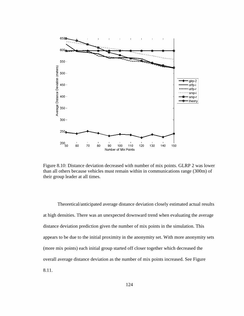
124
Figure 8.10: Distance deviation decreased with number of mix points. GLRP 2 was lower
than all others because vehicles must remain within in communications range (300m) of
their group leader at all times.
Theoretical/anticipated average distance deviation closely estimated actual results
at high densities. There was an unexpected downward trend when evaluating the average
distance deviation prediction given the number of mix points in the simulation. This
appears to be due to the initial proximity in the anonymity set. With more anonymity sets
(more mix points) each initial group started off closer together which decreased the
overall average distance deviation as the number of mix points increased. See Figure
8.11.

125
Figure 8.11: Time of anonymity remained consistent with increasing vehicle density. On-
the-fly models outperformed other models.
8.5.3 Anonymity Duration
Stationary mix point models performed consistently with predictions regarding
the time of anonymity, or anonymity duration of the anonymized vehicles. On-the-fly
models exceeded predicted performance at all density levels, and the group model
performed better at higher densities. See Figure 8.12.
The reason on-the-fly models performed better is because on average they started
closer to the center of the region, the optimal point to maximize time of anonymity.
Recall the experiment was set up for vehicles to enter a region, execute a privacy
protocol, and then try to maintain anonymity and connectivity before exiting the region,
when privacy would no longer be maintained. The group leader model is similar to the
on-the-fly model in that it does not use stationary mix points, so GLRP outperformed
SMP for the same reason.

126
In order to maintain constant overall system anonymity, for each density level a
stationary mix point was selected based on its ability to anonymize 50% of all vehicles.
The region was 3000x3000m so the centroid was (1500,1500). However, for SMP
privacy models the rural mobility model set the mix point at (2290,800); the urban
mobility model at (1430,2490); and the city mobility model at (390,1710). Stationary mix
points being closer to the edge, they were more likely to suffer from vehicles exiting
earlier and therefore having shorter times of anonymity, reducing overall time of
anonymity.
8.5.4 Number of Vehicles Anonymized
The simulation was set up to ensure relative consistency between models with
respect to number of vehicles anonymized, n. Figure 8.12 shows performance results.
Figure 8.12: Number of vehicles anonymized increased with density. Simulation was set
up to ensure relative consistency between models with respect to number of vehicles
anonymized.
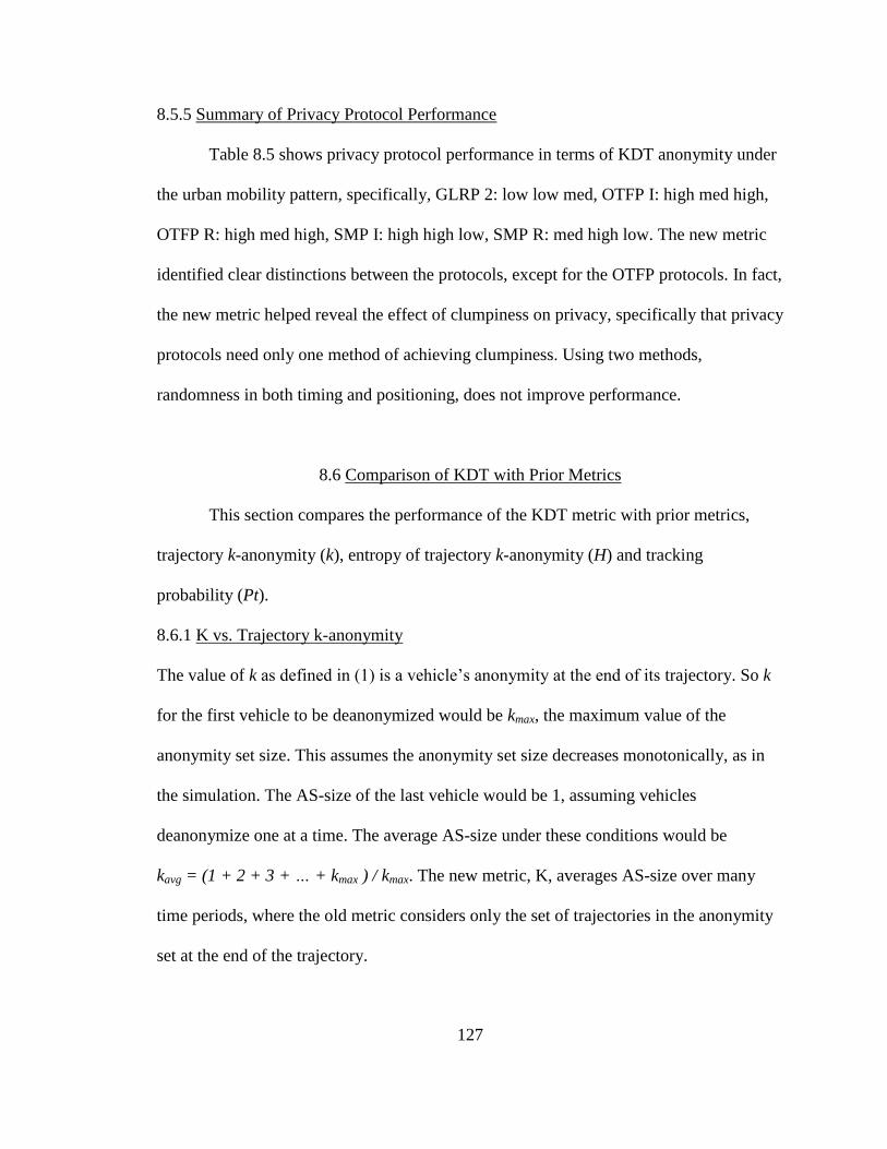
127
8.5.5 Summary of Privacy Protocol Performance
Table 8.5 shows privacy protocol performance in terms of KDT anonymity under
the urban mobility pattern, specifically, GLRP 2: low low med, OTFP I: high med high,
OTFP R: high med high, SMP I: high high low, SMP R: med high low. The new metric
identified clear distinctions between the protocols, except for the OTFP protocols. In fact,
the new metric helped reveal the effect of clumpiness on privacy, specifically that privacy
protocols need only one method of achieving clumpiness. Using two methods,
randomness in both timing and positioning, does not improve performance.
8.6 Comparison of KDT with Prior Metrics
This section compares the performance of the KDT metric with prior metrics,
trajectory k-anonymity (k), entropy of trajectory k-anonymity (H) and tracking
probability (Pt).
8.6.1 K vs. Trajectory k-anonymity
The value of k as defined in (1) is a vehicle’s anonymity at the end of its trajectory. So k
for the first vehicle to be deanonymized would be kmax, the maximum value of the
anonymity set size. This assumes the anonymity set size decreases monotonically, as in
the simulation. The AS-size of the last vehicle would be 1, assuming vehicles
deanonymize one at a time. The average AS-size under these conditions would be
kavg = (1 + 2 + 3 + … + kmax ) / kmax. The new metric, K, averages AS-size over many
time periods, where the old metric considers only the set of trajectories in the anonymity
set at the end of the trajectory.
128
TABLE 8.5
Privacy Protocol Performance (Urban Mobility Pattern)
Protocol K D T kmax H Pt
GLRP-2 2.00 224.40 125.12 2.00 1.00 0.554
OTFP-I 28.42 488.58 202.69 18.81 4.23 0.602
OTFP-R 27.06 487.63 202.93 19.23 4.27 0.597
SMP-I 26.05 717.57 114.08 20.81 4.38 0.571
SMP-R 19.87 714.39 114.16 24.31 4.60 0.509
Why is this important? Because, prior to embarking on a trajectory, a driver does
not know when an attacker will try to deanonymize her. If the attacker investigates
historical data and has access to all trajectory information, then the only value of k that
matters is the one for the last time interval in the trajectory. However, if a driver wants to
choose a privacy protocol that protects her in real time, then it is critical to consider the
level of anonymity all along the entire trajectory. This is analogous to the value of car
insurance. Looking at the expense historically, if you never had an accident, then car
insurance was a waste of money. But looking at the expense as protection against future
risks, it may be worthwhile.
Figure 8.13 shows the value of K for each privacy protocol. Figure 8.13 compares
the average values of kmax (right) with the value of k at the beginning of a trajectory.

129
Figure 8.13: K vs. trajectory k-anonymity. The latter does not incorporate the effect of
higher anonymity in earlier time intervals and consequently reports lower values of k for
clumpy protocols and higher values for uniform protocols. The chart at right shows
average maximum anonymity set size, kmax.
8.6.2 H[K] vs. Entropy of Trajectory k-anonymity
In evaluating the relative merits of privacy protocols, the same conclusions apply
using K vs. kmax, as those using H[K] vs. H[kmax]. See Figure 8.14 and compare with
Figure 8.13. Researchers in [25] contend that H is preferable to k to quantify the
information content in a trajectory. However, this requires knowing ahead of time how
many positions are possible in the mobility pattern. Since we cannot know this for certain
we prefer K, rather than H[K].

130
Figure 8.14: Information entropy. The same conclusions regarding privacy protocol
performance apply using K vs. kmax, as those using H[K] vs. H[kmax].
8.6.3 KDT vs. Tracking Probability
Tracking probability is a measure of an entity’s chance of having no privacy
protection at all. Unlike other metrics for tracking probability, the lower the better.
GLRP-2 provided the lowest (best) overall tracking probability, 0.444, a result skewed by
performance in rural pattern. All other protocols delivered higher (worse) tracking
probabilities than the theoretical prediction, 0.5. See Figure 8.15.
Clumpy protocols performed worse than SMP-R. In general, the higher (better)
the average anonymity set size the higher (worse) the tracking probability, but differences
were slight and inconsistent. So the decision to use KDT over Pt may depend on whether
a potential target prefers a high level KDT or a low chance of having no protection at all
at rural vehicle densities.

131
Figure 8.15. Tracking probability. Privacy protocols performed similarly because the
simulation was deliberately set up to anonymize roughly half of the vehicles. GLRP-2
provided the lowest (best) overall Pt value.
8.7 Summary
To measure continuous network location privacy what is needed is a metric that
answers three questions about VANET privacy protocols. (1) How much anonymity does
a protocol provide, given trajectories with fluctuating anonymity set sizes? (2) How much
dispersion does a protocol provide, given trajectories with fluctuating distance
deviations? (3) How long does a protocol anonymize trajectories? This research has
proposed KDT anonymity, a composite metric for improving the granularity of the
measurement of the property of anonymity over space and time during a trajectory.
Simulation showed how KDT can be used to compare privacy protocols, and how
KDT compares with other metrics. The primary advantage of KDT over prior metrics is
that it incorporates changes in the magnitude of anonymity over time. While trajectory
k-anonymity considers AS size at the end of a trajectory, K is the average AS size over

132
the entire duration of the trajectory. Figure 8.15 shows that clumpy privacy protocols
have higher K values. This is because more vehicles belong to larger anonymity sets for
longer periods of time. This effect is not revealed using trajectory k anonymity.
Another advantage of KDT is it incorporates the magnitude of dispersion, i.e.
distance deviation, over time. Under conditions where a potential target values how far
she is from her decoys, the D component of KDT becomes a valuable consideration in
selecting a privacy protocol.
Finally, if before embarking on a trajectory a potential target values how long she
may be anonymized, the T component of KDT becomes a valuable consideration in
selecting a privacy protocol.

133
CHAPTER NINE
CONCLUSION
This dissertation has reviewed dummy event based location privacy protocols,
and has offered definitions and metrics which would apply to any location privacy
protocols. Specifically, this work has shown the following.
There is a list of twelve properties that help define the scope of desirable
attributes of location privacy preserving protocols. This list offers a “big picture”
perspective to help categorize and understand past research and perhaps focus current and
future research.
A composite metric, KDT, offers advantages over traditional metrics. Vehicles
travel fast, often on predictable paths. In order for privacy to be effective, vehicles should
be anonymized amongst other vehicles, as in k-anonymity, but there should be some
significant distance between target vehicles and other members of the anonymity set.
Further, there should be significant duration of time during which a vehicle is
anonymous. This composite metric would help researchers to compare and contrast
privacy protocols over a wider range of important considerations.
Dummy locations which are not realistic in vehicular contexts may be detectable
(map deanonymizable) as fakes because location coordinates can be cross-referenced and
validated using maps. This problem can be resolved by restricting dummy vehicles to
roadways, as in RRVT.
Endpoint protection zones, EPZs, protect vehicle location privacy from
deanonymization. If LBS administrators can correlate origin and destination points with

134
home and work addresses, they can link identity and location of vehicle owners. This is
not possible if vehicles remain transmission-silent in their respective EPZs.
EPZs protect vehicle location privacy from collusion between LBS administrators
and RSU administrators. Even if LBS administrators can verify with RSUs the locations
of transmissions at their points of origination, they cannot be certain which vehicle from
the EPZ is making the request unless they have additional information beyond the scope
of this study.
The effectiveness of EPZs depends upon density, multiple LBS users originating
from each EPZ. In sparsely populated areas, the EPZ model may be ineffective. One
workaround might be encouraging local friends and family to use LBS. Another
workaround might be to increase EPZ sizes in sparsely populated areas. The practicality
of this is a subject of future study. Perhaps the most important finding of this paper is that
a small increase in LBS users in a sparsely populated area, which may yield only a
proportional effect in anonymity set size, may have a much greater effect on tracking
probability.
An interesting property of the EPZ model is that it provides protection even if
only one LBS user from an EPZ is active outside that EPZ. The LBS administrator cannot
know which LBS user is active. This implies that LBS users especially concerned about
privacy could register under multiple false identities, or have friends and family who do
not use the LBS register under real identities. In this way a single person could achieve
k-anonymity > 1.0.
The EPZ and PARROTS (PBD) protocols address conditions, (1) when the LBS
requires continuous precise location data in a vehicular ad hoc network, (2) when the

135
LBS administrator colludes with administrators of vehicular wireless access points (a.k.a.
roadside units, or RSUs), and (3) when precise location data can be deanonymized using
map databases linking vehicle positions with vehicle owners' home/work addresses and
geographic coordinates. Simulations using realistic vehicle traffic mobility patterns
showed PARROTS increased average privacy levels in high vehicle density conditions
when deployed in combination with EPZs, and increased them even more effectively in
low vehicle density conditions.
An inverse exponential relationship exists between the proportion of vehicles
transmitting BSMs and the proportion of potential collisions unprotected by BSMs. If
privacy protocols must include a silent period, then perhaps as many vehicles as possible
should execute privacy protocols when any vehicles decide to go transmission silent. This
is because the marginal loss in collision protection is greatest when one single vehicle
decides not to transmit BSMs while all others do. The Safety-Silence Tradeoff Equation
(SSTE) can estimate the cost of VANET privacy methods that require silent periods. This
can be done by computing the likelihood of crashes between combinations of vehicles at
intersections.
Simulation showed how KDT can be used to compare privacy protocols, and how
KDT compares with other metrics. The primary advantage of KDT over prior metrics is
that it incorporates changes in the magnitude of anonymity over time. While trajectory
k-anonymity considers AS size at the end of a trajectory, K is the average AS size over
the entire duration of the trajectory. Figure 8.15 shows that clumpy privacy protocols
have higher K values. This is because more vehicles belong to larger anonymity sets for
longer periods of time. This effect is not revealed using trajectory k anonymity.

136
Another advantage of KDT is it incorporates the magnitude of dispersion, i.e.
distance deviation, over time. Under conditions where a potential target values how far
she is from her decoys, the D component of KDT becomes a valuable consideration in
selecting a privacy protocol.
Finally, if before embarking on a trajectory a potential target values how long she
may be anonymized, the T component of KDT becomes a valuable consideration in
selecting a privacy protocol.

137
REFERENCES
[1] Bush, I. (2013, Feb 25). GM, AT&T readying in-vehicle wi-fi.
http://philadelphia.cbslocal.com/2013/02/25/gm-att-readying-in-vehicle-wi-fi/
[2] Johnson, L. (2012, Oct 31). Location-based services to bring in $4b revenue in
2012: study.
http://www.mobilemarketer.com/cms/news/research/14115.htmlhttp://www.mobil
emarketer.com/cms/news/research/14115.html
[3] Koslowski, T. (2012, Jan 3). Your connected vehicle is arriving.
http://www.technologyreview.com/news/426523/your-connected-vehicle-is-
arriving/
[4] IEEE Standard for Wireless Access in Vehicular Environments Security Services
for Applications and Management Messages," IEEE Std 1609.2-2013 (Revision
of IEEE Std 1609.2-2006) , vol., no., pp.1,289, April 26 2013, doi:
10.1109/IEEESTD.2013.6509896
[5] Kenney, John B. "Dedicated short-range communications (DSRC) standards in
the United States." Proceedings of the IEEE 99.7 (2011): 1162-1182.
[6] Corser, G., Fu, H., Shu, T., D'Errico, P., Ma, W. (2013). "Endpoint Protection
Zone (EPZ): Protecting LBS User Location Privacy Against Deanonymization
and Collusion in Vehicular Networks." The 2nd International Conference on
Connected Vehicles & Expo (ICCVE 2013).
[7] Sampigethaya, K., Huang, L., Li, M., Poovendran, R., Matsuura, K., & Sezaki, K.
(2005). CARAVAN: Providing location privacy for VANET. Washington Univ
Seattle Dept Of Electrical Engineering.
[8] Guo, J., Baugh, J. P., & Wang, S. (2007, May). A group signature based secure
and privacy-preserving vehicular communication framework. In 2007 Mobile
Networking for Vehicular Environments (pp. 103-108). IEEE.
[9] Sun, Y., Lu, R., Lin, X., Shen, X., & Su, J. (2010). An efficient pseudonymous
authentication scheme with strong privacy preservation for vehicular
communications. Vehicular Technology, IEEE Transactions on, 59(7), 3589-
3603.
[10] Shokri, R., Freudiger, J., & Hubaux, J. P. (2010). A unified framework for
location privacy. 3rd Hot Topics in Privacy Enhancing Technologies (HotPETs).
138
[11] Chow, R., & Golle, P. (2009, November). Faking contextual data for fun, profit,
and privacy. In Proceedings of the 8th ACM workshop on Privacy in the
electronic society (pp. 105-108). ACM.
[12] Kido, H., Yanagisawa, Y., & Satoh, T. (2005, July). An anonymous
communication technique using dummies for location-based services. In
Pervasive Services, 2005. ICPS'05. Proceedings. International Conference on (pp.
88-97). IEEE.
[13] Krumm, J. (2009). Realistic driving trips for location privacy. In Pervasive
Computing (pp. 25-41). Springer Berlin Heidelberg.
[14] Lu, H., Jensen, C. S., & Yiu, M. L. (2008, June). Pad: Privacy-area aware,
dummy-based location privacy in mobile services. In Proceedings of the Seventh
ACM International Workshop on Data Engineering for Wireless and Mobile
Access (pp. 16-23). ACM.
[15] You, T. H., Peng, W. C., & Lee, W. C. (2007, May). Protecting moving
trajectories with dummies. In Mobile Data Management, 2007 International
Conference on (pp. 278-282). IEEE.
[16] Yang, Q., Lim, A., Ruan, X., & Qin, X. (2010, December). Location privacy
protection in contention based forwarding for VANETs. In Global
Telecommunications Conference (GLOBECOM 2010), 2010 IEEE (pp. 1-5).
IEEE.
[17] Machanavajjhala, A., Kifer, D., Gehrke, J., & Venkitasubramaniam, M. (2007). l-
diversity: Privacy beyond k-anonymity. ACM Transactions on Knowledge
Discovery from Data (TKDD), 1(1), 3.
[18] Li, N., Li, T., & Venkatasubramanian, S. (2007, April). t-closeness: Privacy
beyond k-anonymity and l-diversity. In Data Engineering, 2007. ICDE 2007.
IEEE 23rd International Conference on (pp. 106-115). IEEE.
[19] Dwork, C. (2006). Differential privacy. In Automata, languages and programming
(pp. 1-12). Springer Berlin Heidelberg.
[20] Beresford, A. R., & Stajano, F. (2003). Location privacy in pervasive computing.
Pervasive Computing, IEEE, 2(1), 46-55.
[21] Uzcategui, R.; Acosta-Marum, G., "Wave: A tutorial," Communications
Magazine, IEEE, vol.47, no.5, pp.126,133, May 2009, doi:
10.1109/MCOM.2009.4939288

139
[22] Harri, J., Filali, F., & Bonnet, C. (2009). Mobility models for vehicular ad hoc
networks: a survey and taxonomy. Communications Surveys & Tutorials, IEEE,
11(4), 19-41.
[23] Baumann, R., Legendre, F., & Sommer, P. (2008, May). Generic mobility
simulation framework (GMSF). In Proceedings of the 1st ACM SIGMOBILE
workshop on Mobility models (pp. 49-56). ACM.
[24] http://gmsf.sourceforge.net/
[25] http://www.lst.inf.ethz.ch/research/ad-hoc/car-traces
[26] Sweeney, Latanya. "k-anonymity: A model for protecting privacy." International
Journal of Uncertainty, Fuzziness and Knowledge-Based Systems 10.05 (2002):
557-570.
[27] Gruteser, M., & Grunwald, D. (2003). Anonymous usage of location-based
services through spatial and temporal cloaking. In Proceedings of the 1st
international conference on Mobile systems, applications and services (pp. 31-42).
ACM.
[28] Corser, G., Fu, H., Shu, T. D'Errico, P., Ma, W. (2013, December). Endpoint
Protection Zone (EPZ): Protecting LBS user location privacy against
deanonymization and collusion in vehicular networks. In Second International
Conference on Connected Vehicles & Expo. IEEE.
[29] Glassbrenner, D. (2003). Estimating the lives saved by safety belts and air bags.
US DOT, National Highway Traffic Safety Administration , page, 5, 12.
[30] http://icsw.nhtsa.gov/safercar/ConnectedVehicles/pages/v2v.html.
[31] PBS, Feds to announce decision on new automobile safety technology. Feb 3,
2014. http://www.pbs.org/newshour/rundown/feds-announce-decision-new-
automobile-safety-technology/
[32] Dedicated Short Range Communications (DSRC) Message Set Dictionary, SAE
Std J2735, SAE International,DSRC committee, 2009. SAE.
[33] Raya, M., & Hubaux, J. P. (2005, September). The security of VANETs. In
Proceedings of the 2nd ACM international workshop on Vehicular ad hoc
networks (pp. 93-94). ACM.
[34] TS3290/00A. On-Board Unit. Kapsch. Accessed 2014-04-23.
https://www.kapsch.net/ktc/downloads/datasheets/in-vehicle/5-8/Kapsch-KTC-
DS-OBU-TS3290_00A?lang=en-US

140
[35] Lee, E. K., Yang, S., Oh, S. Y., & Gerla, M. (2009, October). RF-GPS: RFID
assisted localization in VANETs. In Mobile Adhoc and Sensor Systems, 2009.
MASS'09. IEEE 6th International Conference on (pp. 621-626). IEEE.
[36] Bohlooli, A., & Jamshidi, K. (2012). A GPS-free method for vehicle future
movement directions prediction using SOM for VANET. Applied Intelligence,
36(3), 685-697.
[37] http://www-fars.nhtsa.dot.gov/Main/index.aspx
[38] http://www.fhwa.dot.gov/policyinformation/travel_monitoring/tvt.cfm
[39] Haas, J. J., Hu, Y. C., & Laberteaux, K. P. (2011). Efficient certificate revocation
list organization and distribution. Selected Areas in Communications, IEEE
Journal on, 29(3), 595-604.
[40] http://www.merriam-webster.com/dictionary/anonymous
[41] http://www.merriam-webster.com/dictionary/pseudonymous
[42] Dıaz, C., Claessens, J., Seys, S., & Preneel, B. (2002, May). Information theory
and anonymity. In Proceedings of the 23rd Symposium on Information Theory in
the Benelux (pp. 179-186).
[43] Shokri, R., Troncoso, C., Diaz, C., Freudiger, J., & Hubaux, J. P. (2010, October).
Unraveling an old cloak: k-anonymity for location privacy. In Proceedings of the
9th annual ACM workshop on Privacy in the electronic society (pp. 115-118).
ACM.
[44] Coull, S. E., Wright, C. V., Keromytis, A. D., Monrose, F., & Reiter, M. K.
(2008). Taming the devil: Techniques for evaluating anonymized network data. In
Network and Distributed System Security Symposium 2008: February 10-13,
2008, San Diego, California: Proceedings (pp. 125-135). Internet Society.
[45] Xiao, X., & Tao, Y. (2007, June). M-invariance: towards privacy preserving re-
publication of dynamic datasets. In Proceedings of the 2007 ACM SIGMOD
international conference on Management of data (pp. 689-700). ACM.
[46] Dewri, R., Ray, I., & Whitley, D. (2010, May). Query m-invariance: Preventing
query disclosures in continuous location-based services. In Mobile Data
Management (MDM), 2010 Eleventh International Conference on (pp. 95-104).
IEEE.

141
[47] Kelly, D. J., Raines, R. A., Grimaila, M. R., Baldwin, R. O., & Mullins, B. E.
(2008, October). A survey of state-of-the-art in anonymity metrics. In
Proceedings of the 1st ACM workshop on Network data anonymization (pp. 31-
40). ACM.
[48] Park, H., & Kent, S. (2009). Traceable anonymous certificate.
[49] Chaum, D. (1983, January). Blind signatures for untraceable payments. In
Advances in cryptology (pp. 199-203). Springer US.
[50] Corser, G., Fu, H., Shu, T. D'Errico, P., Ma, W., Leng, S., Zhu, Y. (2014, June).
Privacy-by-Decoy: Protecting Location Privacy Against Collusion and
Deanonymization in Vehicular Location Based Services. In 2014 IEEE Intelligent
Vehicles Symposium. IEEE. Dearborn, MI.
[51] Alnahash, N., Corser, G., Fu, H. (2014, April). Protecting Vehicle Privacy using
Dummy Events. In 2014 American Society For Engineering Education North
Central Section Conference (ASEE NCS 2014).
[52] M. Raya and J.-P. Hubaux, “Security Aspects of Inter-Vehicle Communications,”
in Proc. of Swiss Transport Research Conference, March 2005.
[53] M. Raya and J.-P. Hubaux, “The Security of Vehicular Ad Hoc Neworks,” in
Proc. of the ACM Workshop on Security of Ad hoc and Sensor Networks (SASN),
pp. 11– 21, November 2005, pp. 11–21.
[54] F. Dotzer, “Privacy Issues in Vehicular Ad hoc Networks,” in Proc. of the
Workshop on Privacy Enhancing Technologies (PET), June 2005, pp. 197–209.
[55] E. Schoch, F. Kargl, T. Leinmuller, S. Schlott, and P. Papadimitratos, “Impact of
Pseudonym Changes on Geographic Routing in VANETs,” in Proc. of the
European Workshop on Security and Privacy in Ad hoc and Sensor Networks
(ESAS), October 2006, pp. 43–57.
[56] L. Buttyan, T. Holczer, and I. Vajda, “On The Effectiveness Of Changing
Pseudonyms to Provide Location Privacy in Vanets,” InProc of European
workshop on security and privacy in ad hoc and sensor networks (ESAS),
Cambridge, 2007.
[57] J. J. Haas, Y.-C. Hu, and K. P. Laberteaux, “The Impact of Key Assignment on
VANET Privacy,” Security and Communication Networks 2009, John Wiley &
Sons, Ltd., September, 2009.

142
[58] Y. Sun, R. Lu, X. Lin, X. Shen, and J. Su, “NEHCM: A Novel and Efficient
Hash-chain based Certificate Management Scheme for Vehicular
Communications,” Proc. Chinacom'10, Beijing, China, August 25-27, 2010.
[59] L. Zhang, Q. Wu, A. Solanas, and J. Domingo-Ferrer, “A Scalable Robust
Authentication Protocol for Secure Vehicular Communications,” IEEE
Transactions on Vehicular Technology, vol. 59, no. 4, pp. 1606-1617, May 2010.
[60] Y. Sun, B. Zhao, and J. Su, “ECHO: Efficient Certificate Updating Scheme by
Vehicle-to-Vehicle Communications,” The 4th International Conference on
Frontier of Computer Science and Technology (FCST 2009), Shanghai, China,
December 17-19, 2009.
[61] B. Wiedersheim, Z. Ma, F. Kargl, and P. Papadimitratos, “Privacy In Inter-
Vehicular Networks: Why Simple Pseudonym Change Is Not Enough,” in Proc.
7th International Conference on wireless On-demand Network Systems and
Services (WONS'10), pp. 176-183, 2010.
[62] Y. Sun, R. Lu, X. Lin, X. Shen, and J. Su, “An Efficient Pseudonymous
Authentication Scheme with Strong Privacy Preservation for Vehicular
Communications,” IEEE Trans. on Vehicular Technology, to appear.
[63] J. J. Haas, Y.-C. Hu, and K. P. Laberteaux, “Design and Analysis of a
Lightweight Certificate Revocation Mechanism for VANET,” in Proceedings of
the Sixth ACM International Workshop on Vehicular Ad Hoc Networks (VANET
2009). ACM, Beijing, China, September 2009.
[64] M. Gruteser and D. Grunwald, “Anonymous Usage Of Location-Based Services
Through Spatial And Temporal Cloaking,” in Proc. of the ACM International
Conference on Mobile Systems MobiSys, May 2003, pp. 31–42.
[65] S. Kato, S. Tsugawa, K. Tokuda, T. Matsui, and H. Fujii, “Vehicle Control
Algorithms For Cooperative Driving With Automated Vehicles And Intervehicle
Communications,” IEEE Trans. on Intelligent Transportation Systems, vol. 3, no.
3, pp. 155–161, September 2002.
[66] R. Hochnadel and M. Gaeta, “A Look Ahead Network (LANET) Model for
Vehicle-to-vehicle Communications Using DSRC,” in Proc. of World Congress
on Intelligent Transportation Systems, November 2003.
[67] M. Raya, A. Aziz, and J.-P. Hubaux, “Efficient Secure Aggregation in VANETs,”
in Proc. of the 3rd international workshop on Vehicular Ad hoc Networks
(VANET), pp. 67–75, 2006.

143
[68] L. Huang, K. Matsuura, H. Yamane, and K. Sezaki, “Enhancing Wireless
Location Privacy Using Silent Period,” in Proc. of the IEEE Wireless
Communications and Networking Conference (WCNC), pp. 1187–1192, March
2005.
[69] L. Huang, K. Matsuura, H. Yamane, and K. Sezaki, “Towards Modeling Wireless
Location Privacy,” in Proc. of the Workshop on Privacy Enhancing Technologies
(PET), pp. 59–77, June 2005.
[70] D. Chaum, “The Dining Cryptographers Problem: Unconditional Sender and
Recipient Untraceability,” Journal of Cryptology, vol. 1, pp. 65–75, 1988.
[71] Serjantov and G. Danezis, “Towards an Information Theoretic Metric for
Anonymity,” in Proc. of the Workshop on Privacy Enhancing Technologies
(PET), pp. 41–53, April 2002.
[72] F. L. Mannering, W. P. Kilareski,and S. S. Washburn, “Principles of Highway
Engineering and Traffic Analysis,” 3rd Ed, ISBN: 978-0-471-47256-8, Wiley
Publishers, 2004.
[73] D. Boneh, X. Boyen, and H. Shacham, “Short Group Signature,” in Proc.
Advances in Cryptography – Crypto’04, ser. LNCS, vol. 3152, Springer-Verlag,
pp. 41-55, 2004.
[74] J. H. Song, V. W. S. Wong, and V. C. M, Leung, “Wireless Location Privacy
Protection in Vehicular Ad hoc Networks,” Springer-Mobile Networks and
Applications, Vol. 15, No. 1. , pp. 160-171, Feb. 2010.
[75] G. Yvonne, W. Bernhard, and G. Hans Peter, “Medium Access Concept for
VANETs Based on Clustering,” in the 66th IEEE VTC, pp. 2189-2193, Sep. 2007.
[76] P. Fan, “Improving Broadcasting Performance by Clustering with Stability for
Inter-vehicle Communication,” Proceedings of the 65th IEEE VTC, Dublin,
Ireland, April 2007.
[77] W. Zhiagang, L. Lichuan, Z. MengChu, and A. Nirwan, “A Position-Based
Clustering Technique for Ad Hoc Intervehicle Communication,” IEEE
transactions on Man and Cybernetics, vol.38, No.2, March 2008.
[78] Z. Y. Rawashdeh and S. M. Mahmud, “Toward Strongly Connected Clustering
Structure in Vehicular Ad Hoc Networks,” Proceedings of the 70th IEEE VTC,
Alaska, USA, Sep. 2009.
144
[79] L. Buttyán, T. Holczer, A. Weimerskirch, and W. Whyte, “SLOW: A Practical
Pseudonym Changing Scheme for Location Privacy in VANETs,” IEEE
Vehicular Networking Conference (VNC), Tokyo, Japan, October 2009.
[80] IEEE P802.11p TM/D3.0 Draft Standard for Information Technology –
Telecommunications and Information Exchange between Systems - Local and
metropolitan area networks - Part 11: Wireless LAN Medium Access Control
(MAC) and Physical Layer (PHY) Specifications.
[81] Wiedersheim, Z. Ma, F. Kargl, and P. Papadimitratos, “Privacy in Inter-Vehicular
Networks: Why Simple Pseudonym Change is Not Enough,” in Proc. 7th
International Conference on wireless On-demand Network Systems and Services
(WONS'10), pp. 176-183, 2010.
[82] Gedik and L. Lu, “Location Privacy in Mobile Systems: A Personalized
Anonymization Model,” In Proceedings of the 25th IEEE ICDCS 2005, pp 620-
629, Washington, DC, USA, 2005.
[83] B. Hoh and M. Gruteser, “Protecting Location Privacy Through Path Confusion,”
In Proceedings of IEEE Create-Net Secure Comm, Athens, Greece, Sep. 2005.
[84] L. Zhou and Z. J. Haas, “Securing Ad Hoc Networks,” IEEE Net., vol. 13, no. 6,
Nov./Dec. 1999.
[85] J. Lundberg, “Routing Security in Ad Hoc Networks,” Helsinki University of
Technology, http://citeseer.nj.nec.com/400961.html
[86] M. Royer and C. K. Toh, “A Review of Current Routing Protocols for Ad Hoc
Mobile Wireless Networks,” IEEE Personal Communications, pp. 46-55, April
1999.
[87] B. Johnson and D. A. Maltz, “Dynamic Source Routing in Ad Hoc Wireless
Networks,” Mobile Computing, edited by Tomasz Imielinski and Hank Korth,
Chapter 5, pages 153-181, Kluwer Academic Publishers, 1996.
[88] C. E. Perkins and P. Bhagwat, “Highly Dynamic Destination-Sequenced
Distance-Vector Routing (DSDV) for Mobile Computers,” Computer
Communications Review, pp. 234-244, October 1994.
[89] H. Deng, W. Li, and D. P. Agrawal, “Routing Security in Wireless Ad Hoc
Network,” IEEE Communications Magzine, vol. 40, no. 10, October 2002.

145
[90] Sanjay Ramaswamy, Huirong Fu, Manohar Sreekantaradhya, John Dixon, and
Kendall Nygard, “Prevention of Cooperative Black Hole Attack in Wireless Ad
Hoc Networks,” International Conference on Wireless Networks (ICWN’03), Las
Vegas, Nevada, USA, June 2003.
[91] Jian Yin and Sanjay Madria, “A Hierarchical Secure Routing Protocol against
Black Hole,” IEEE SUTC 2006 Taiwan, 5-7 June 2006.
[92] Xiaoyan Hong, Kaixin Xu, and Mario Gerla, “Scalable Routing Protocols for
Mobile Ad hoc Networks,” IEEE Network Vol.16(4), pp11-21, July/August 2002.
[93] Elizabeth M. Royer and Chai-Keong Toh, “A Review of Current routing
Protocols for Ad Hoc Mobile Wireless Networks,” IEEE Personal
Communications, pp 46-55, April 1999.
[94] Sanjay Ramaswamy, Huirong Fu, and Kendall E. Nygard, “Simulation Study of
Multiple Black Holes Attack on Mobile Ad Hoc Networks,” International
Conference on Wireless Networks (ICWN’ 05), Las Vegas, Nevada, Jun. 2005.
[95] Hesiri Weerasinghe and Huirong Fu, “ESAP: Efficient and Scalable
Authentication Protocol for Vehicular Ad hoc Networks,” IEEE Globecom 2010
Workshop on Ubiquitous Computing and Networks (UbiCoNet 2010), December,
2010.
[96] Hesiri Weerasinghe and Huirong Fu, “Enhancing Location Privacy for Vehicular
Ad hoc Networks,” under Preparation
[97] Hesiri Weerasinghe, Huirong Fu, and Supeng Leng, “Anonymous Service Access
Protocol for Vehicular Ad hoc Networks,” 6th International Conference on
Information Assurance and Security (IEEE IAS 2010), Atlanta, USA, August,
2010.
[98] Hesiri Weerasinghe, Huirong Fu, and Raymond Tackett, “Verifying Position and
Velocity for Vehicular Ad-Hoc Networks,” Wiley Journal of Security and
Communication Networks, 15 July 2010.
[99] Huirong Fu, Hesiri Weerasinghe, and Ye Zhu, “Improving Hierarchical Mobile
Certification Authority for Wireless Ad Hoc Networks,” Submitted to Elsevier
Journal of Computer Communication
[100] Hesiri Weerasinghe and Huirong Fu, “Preventing Cooperative Black Hole Attacks
in Mobile Ad Hoc Networks: Simulation Implementation and Evaluation,” IJSEIA
– International Journal of Software Engineering and Its Applications, vol. 2, No.
3, July 2008.

146
[101] Hesiri Weerasinghe and Huirong Fu, “Preventing Cooperative Black Hole Attacks
in Mobile Ad Hoc Networks: Simulation Implementation and Evaluation,” FGCN
WAMSNet-07, South Korea, Dec. 6-8 2007.
[102] Hesiri Weerasinghe, Huirong Fu, and Supeng Leng, “Providing Location Privacy
for Online-services in Vehicular Ad hoc Networks”, accepted for Journal of
Information Assurance and Security.


