SECTIONFIVE Environmental Information · impacts on paleontological resources that could result...
28
SECTIONFIVE Environmental Information 5.8-1 5. Section 7 FIVE Environmental Information 5.8 PALEONTOLOGY 5.8.1 Introduction Paleontological resources (fossils) are the remains or traces of prehistoric animals and plants. Fossils are important scientific and educational resources because of their use in (1) documenting the presence and evolutionary history of particular groups of now extinct organisms, (2) reconstructing the environments in which these organisms lived, (3) and in determining the relative ages of the strata in which they occur. Fossils are also important in determining the geologic events that resulted in the deposition of the sediments in which they were buried. This section of the Application for Certification (AFC) summarizes the potential environmental impacts on paleontological resources that could result from construction of the Bullard Energy Center (BEC). Section 5.8.2, Laws, Ordinances, Regulations, and Standards, lists the federal, state, county, and city laws, ordinances, regulations, and standards (LORS) and the professional standards that protect paleontological resources. Section 5.8.3, Affected Environment, describes the existing environment that could be affected by the BEC project. Section 5.8.4, Environmental Consequences, describes the potential impacts on paleontological resources resulting from construction and operation of the project. The cumulative impacts to paleontological resources are discussed in Section 5.8.5, Cumulative Impacts. Proposed mitigation measures to reduce potential adverse impacts to paleontological resources are discussed in Section 5.8.6, Mitigation Measures. The involved agencies and agency contacts are provided in Section 5.8.7, Involved Agencies and Agency Contacts. Section 5.8.8, Permits Required and Permit Schedule, discusses the status of permits required and permit schedule. Finally, Section 5.8.9, References, lists the references used in preparing this document. This paleontological resources inventory and impact assessment was prepared by Dr. Lanny H. Fisk, PhD, Professional Geologist (PG), a California registered PG and Senior Paleontologist with PaleoResource Consultants. It meets all requirements of the California Energy Commission (CEC) (2000) and the standard measures for mitigating adverse construction-related environmental impacts on significant paleontological resources established by the Society of Vertebrate Paleontology (SVP) (1995, 1996; see Appendix A, Assessment and Mitigation of Adverse Impacts to Nonrenewable Paleontological Resources – Standard Guidelines, and Appendix B, Conditions of Receivership for Paleontological Salvage Collections, of the Paleontology Resources Technical Report). 5.8.2 Laws, Ordinances, Regulations, and Standards Paleontological resources are classified as non-renewable scientific resources and are protected by several federal and state statutes (California Office of Historic Preservation 1983; Marshall 1976; West 1991; Fisk and Spencer 1994; Gastaldo 1999), most notably by the 1906 Federal Antiquities Act and other subsequent federal legislation and policies and by the State of California’s environmental regulations (California Environmental Quality Act of 1970 [CEQA], Section 15064.5). Professional standards for assessment and mitigation of adverse impacts on paleontological resources have been established by the SVP (1995, 1996). Design, construction, and operation of the project, including ancillary facilities, will be conducted in accordance with LORS applicable to paleontological resources. Federal and state LORS applicable to
Transcript of SECTIONFIVE Environmental Information · impacts on paleontological resources that could result...

SECTIONFIVE Environmental Information
5.8-1
5. Section 7 FIVE Environmental Information
5.8 PALEONTOLOGY
5.8.1 Introduction Paleontological resources (fossils) are the remains or traces of prehistoric animals and plants. Fossils are important scientific and educational resources because of their use in (1) documenting the presence and evolutionary history of particular groups of now extinct organisms, (2) reconstructing the environments in which these organisms lived, (3) and in determining the relative ages of the strata in which they occur. Fossils are also important in determining the geologic events that resulted in the deposition of the sediments in which they were buried.
This section of the Application for Certification (AFC) summarizes the potential environmental impacts on paleontological resources that could result from construction of the Bullard Energy Center (BEC). Section 5.8.2, Laws, Ordinances, Regulations, and Standards, lists the federal, state, county, and city laws, ordinances, regulations, and standards (LORS) and the professional standards that protect paleontological resources. Section 5.8.3, Affected Environment, describes the existing environment that could be affected by the BEC project. Section 5.8.4, Environmental Consequences, describes the potential impacts on paleontological resources resulting from construction and operation of the project. The cumulative impacts to paleontological resources are discussed in Section 5.8.5, Cumulative Impacts. Proposed mitigation measures to reduce potential adverse impacts to paleontological resources are discussed in Section 5.8.6, Mitigation Measures. The involved agencies and agency contacts are provided in Section 5.8.7, Involved Agencies and Agency Contacts. Section 5.8.8, Permits Required and Permit Schedule, discusses the status of permits required and permit schedule. Finally, Section 5.8.9, References, lists the references used in preparing this document.
This paleontological resources inventory and impact assessment was prepared by Dr. Lanny H. Fisk, PhD, Professional Geologist (PG), a California registered PG and Senior Paleontologist with PaleoResource Consultants. It meets all requirements of the California Energy Commission (CEC) (2000) and the standard measures for mitigating adverse construction-related environmental impacts on significant paleontological resources established by the Society of Vertebrate Paleontology (SVP) (1995, 1996; see Appendix A, Assessment and Mitigation of Adverse Impacts to Nonrenewable Paleontological Resources – Standard Guidelines, and Appendix B, Conditions of Receivership for Paleontological Salvage Collections, of the Paleontology Resources Technical Report).
5.8.2 Laws, Ordinances, Regulations, and Standards Paleontological resources are classified as non-renewable scientific resources and are protected by several federal and state statutes (California Office of Historic Preservation 1983; Marshall 1976; West 1991; Fisk and Spencer 1994; Gastaldo 1999), most notably by the 1906 Federal Antiquities Act and other subsequent federal legislation and policies and by the State of California’s environmental regulations (California Environmental Quality Act of 1970 [CEQA], Section 15064.5). Professional standards for assessment and mitigation of adverse impacts on paleontological resources have been established by the SVP (1995, 1996). Design, construction, and operation of the project, including ancillary facilities, will be conducted in accordance with LORS applicable to paleontological resources. Federal and state LORS applicable to
SECTIONFIVE Environmental Information
5.8-2
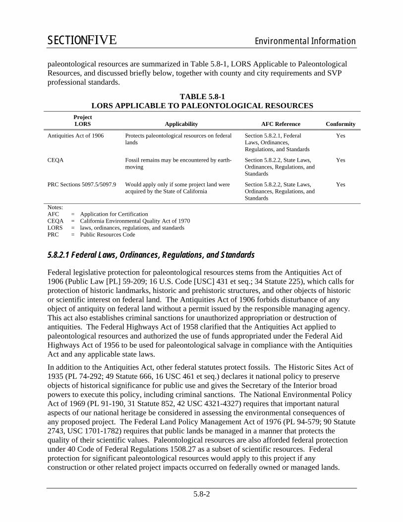
paleontological resources are summarized in Table 5.8-1, LORS Applicable to Paleontological Resources, and discussed briefly below, together with county and city requirements and SVP professional standards.
TABLE 5.8-1 LORS APPLICABLE TO PALEONTOLOGICAL RESOURCES
Project LORS Applicability AFC Reference Conformity
Antiquities Act of 1906 Protects paleontological resources on federal lands
Section 5.8.2.1, Federal Laws, Ordinances, Regulations, and Standards
Yes
CEQA Fossil remains may be encountered by earth-moving
Section 5.8.2.2, State Laws, Ordinances, Regulations, and Standards
Yes
PRC Sections 5097.5/5097.9 Would apply only if some project land were acquired by the State of California
Section 5.8.2.2, State Laws, Ordinances, Regulations, and Standards
Yes
Notes: AFC = Application for Certification CEQA = California Environmental Quality Act of 1970 LORS = laws, ordinances, regulations, and standards PRC = Public Resources Code
5.8.2.1 Federal Laws, Ordinances, Regulations, and Standards
Federal legislative protection for paleontological resources stems from the Antiquities Act of 1906 (Public Law [PL] 59-209; 16 U.S. Code [USC] 431 et seq.; 34 Statute 225), which calls for protection of historic landmarks, historic and prehistoric structures, and other objects of historic or scientific interest on federal land. The Antiquities Act of 1906 forbids disturbance of any object of antiquity on federal land without a permit issued by the responsible managing agency. This act also establishes criminal sanctions for unauthorized appropriation or destruction of antiquities. The Federal Highways Act of 1958 clarified that the Antiquities Act applied to paleontological resources and authorized the use of funds appropriated under the Federal Aid Highways Act of 1956 to be used for paleontological salvage in compliance with the Antiquities Act and any applicable state laws.
In addition to the Antiquities Act, other federal statutes protect fossils. The Historic Sites Act of 1935 (PL 74-292; 49 Statute 666, 16 USC 461 et seq.) declares it national policy to preserve objects of historical significance for public use and gives the Secretary of the Interior broad powers to execute this policy, including criminal sanctions. The National Environmental Policy Act of 1969 (PL 91-190, 31 Statute 852, 42 USC 4321-4327) requires that important natural aspects of our national heritage be considered in assessing the environmental consequences of any proposed project. The Federal Land Policy Management Act of 1976 (PL 94-579; 90 Statute 2743, USC 1701-1782) requires that public lands be managed in a manner that protects the quality of their scientific values. Paleontological resources are also afforded federal protection under 40 Code of Federal Regulations 1508.27 as a subset of scientific resources. Federal protection for significant paleontological resources would apply to this project if any construction or other related project impacts occurred on federally owned or managed lands.

SECTIONFIVE Environmental Information
5.8-3
5.8.2.2 State Laws, Ordinances, Regulations, and Standards
The CEC environmental review process under the Warren-Alquist Act is considered functionally equivalent to that of the CEQA (PRC Sections 15000 et seq.) with respect to paleontological resources. Guidelines for the Implementation of CEQA, as amended 7 September 2004 (Title 14, Chapter 3, California Code of Regulations: 15000 et seq.) define procedures, types of activities, persons, and public agencies required to comply with CEQA, and include as one of the questions to be answered in the Environmental Checklist (Section 15023, Appendix G, Section XIV, Part a) the following: “Will the proposed project directly or indirectly destroy a unique paleontological resource or site?”
Although neither CEQA nor the Guidelines define what is “a unique paleontological resource or site,” CEQA section 21083.2 defines “unique archaeological resources” as “…any archaeological artifact, object, or site about which it can be clearly demonstrated that, without merely adding to the current body of knowledge, there is a high probability that it meets any of the following criteria:
1) contains information needed to answer important scientific research questions and that there is a demonstrable public interest in that information.
2) it has a special and particular quality such as being the oldest of its type or the best available example of its type.
3) is directly associated with a scientifically recognized import prehistoric or historic event.”
With only slight modification, this definition is equally applicable to recognizing “a unique paleontological resource or site.” Additional guidance is provided in CEQA Guidelines section 15064.5(a)(3)(D), which indicates “generally, a resource shall be considered historically significant if it has yielded, or may be likely to yield, information important in prehistory or history.”
Paleontological resources are considered to be significant if they:
• provide important information on the evolutionary trends among organisms, relating living organisms to extinct organisms.
• provide important information regarding development of biological communities or interaction between botanical and zoological biota.
• demonstrate unusual circumstances in biotic history.
• are in short supply and in danger of being depleted or destroyed by the elements, vandalism, or commercial exploitation, and are not found in other geographic localities.
CEQA Guidelines section XVII, part a, of the Environmental Checklist asks a second question equally applicable to paleontological resources: “Does the project have the potential to . . . eliminate important examples of the major periods of California history or pre-history?” Fossils are important examples of the major periods of California prehistory. To be in compliance with CEQA, environmental impact assessments, statements, and reports must answer both these questions in the Environmental Checklist. If the answer to either question is “yes” or “possibly,” a mitigation and monitoring plan must be designed and implemented to protect significant paleontological resources.

SECTIONFIVE Environmental Information
5.8-4
The CEQA lead agency having jurisdiction over a project is responsible to ensure that paleontological resources are protected in compliance with CEQA and other applicable statutes. California PRC section 21081.6, entitled Mitigation Monitoring Compliance and Reporting, requires that the lead agency demonstrate project compliance with mitigation measures developed during the environmental impact review process.
Other state requirements for paleontological resources management are in PRC Chapter 1.7, Section 5097.5 (Statutes 1965, c. 1136, p. 2792), entitled Archaeological, Paleontological, and Historical Sites. This statute defines any unauthorized disturbance or removal of a fossil site or fossil remains on public land as a misdemeanor and specifies that state agencies may undertake surveys, excavations, or other operations as necessary on state lands to preserve or record paleontological resources. This statute would apply to the BEC project if any construction or other related project impacts occurred on state owned or managed lands, if the state or a state agency were to obtain ownership of project lands during the term of the project license, or if construction of the project linear features (natural gas pipeline, cooling and potable water lines, and/or sewer line) were built on state-, county-, or city-owned lands, including streets and highway right-of-ways.
5.8.2.3 County and City Laws, Ordinances, Regulations, and Standards
California Planning and Zoning Law requires each county and city jurisdiction to adopt a comprehensive, long-term general plan for its development. The general plan is a policy document designed to give long range guidance to those making decisions affecting the future character of the planning area. It represents the official statement of the community's physical development as well as its environmental goals. The general plan also acts to clarify and articulate the relationship and intentions of local government to the rights and expectations of the general public, property owners, and prospective investors. Through its general plan, the local jurisdiction informs these groups of its goals, policies, and development standards; thereby communicating what must be done to meet the objectives of the general plan. State planning law requires each jurisdiction to identify environmental resources and to prepare and implement policies which relate to the utilization and management of these resources. Both Fresno County and the City of Fresno have adopted general plans which include goals, objectives, and policies that address the protection of paleontological resources.
In the Fresno County General Plan, Goal OS-J is “To identify, protect, and enhance Fresno County’s important…paleontological…sites and their contributing environment.” Policy OS-J.1 states that “The County shall require that discretionary development projects, as part of any required CEQA review, identify and protect important … paleontological … sites and their contributing environment from damage, destruction, and abuse to the maximum extent feasible.”
The 2025 Fresno General Plan was adopted by the Fresno City Council in November 2002. The Resource Conservation Chapter of the General Plan includes as Objective G-10 to “augment the body of scientific and historic knowledge through identification, appropriate recognition, and promotion of historic and cultural resources.” In the General Plan, paleontological resources are included under the general title “cultural resources,” as they also are in CEQA. Policy G-10-c states that “Unique prehistoric resource sites shall be considered as those archaeological and paleontological sites which:

SECTIONFIVE Environmental Information
5.8-5
• contain information needed to answer important scientific research questions.
• have special quality or unique features, such as being the oldest, largest, or most complete example of a particular type of site or are directly associated with a scientifically recognized prehistoric or historic event or person.”
Policy G-11-d states that “Prehistoric resources (those containing archaeological and paleontological material) shall be protected.
• In any public or private project, it shall be a condition of project permits that work stop immediately in the immediate vicinity of the find if archaeological and/or nonhuman fossil material is encountered on the project site.
If nonhuman fossils are uncovered, the Museum of Paleontology at U.C. Berkeley shall be contacted to obtain a referral list of recognized paleontologists. If the paleontologist determines the material to be significant, it shall be preserved.”
5.8.2.4 Professional Standards
The SVP, a national scientific organization of professional vertebrate paleontologists, has established standard guidelines (SVP 1995, 1996) that outline acceptable professional practices in the conduct of paleontological resource assessments and surveys, monitoring and mitigation, data and fossil recovery, sampling procedures, and specimen preparation, identification, analysis, and curation. Most practicing professional paleontologists in the nation adhere closely to the SVP’s assessment, mitigation, and monitoring requirements as specifically spelled out in its standard guidelines. The SVP’s standard guidelines were approved by a consensus of professional paleontologists and are the standard against which all paleontological monitoring and mitigation programs are judged. Many federal and California state regulatory agencies have either formally or informally adopted the SVP’s “standard guidelines” for the mitigation of construction related adverse impacts on paleontological resources as a measure of professional practice.
Briefly, SVP guidelines recommend that each project have literature and museum archival reviews, a field survey, and, if there is a high potential for disturbing significant fossils during project construction, a mitigation plan that includes monitoring by a qualified paleontologist to salvage fossils encountered, identification of salvaged fossils, determination of their significance, and placement of curated fossil specimens into a permanent public museum collection (such as the designated California State repository for fossils, the University of California Museum of Paleontology [UCMP] at Berkeley).
5.8.3 Affected Environment
5.8.3.1 Geographic Location
The project is located in the western portion of the City of Fresno in north-central Fresno County, California. The center of the proposed power plant site is located approximately at latitude 36º 49'16" North and longitude 119º 54'00" West in the southeast quadrant of Section 4 and adjacent northeast quadrant of Section 9, Township 13 South, Range 19 East. The ground surface in the project vicinity is relatively flat, ranging only between 290 and 305 feet (88 to 92 meters) elevation. The project is located in the eastern margin of the San Joaquin Valley,

SECTIONFIVE Environmental Information
5.8-6
near the westernmost foothills of the Sierra Nevada, and just south of the geographic center of the State of California. The San Joaquin Valley comprises roughly the southern two-thirds of the major north-northwest oriented synclinorium called either the Valle Grande (Clark 1929), Great Valley (Fenneman 1931; Hackel 1966), Central Valley (Jahns 1954), Great Central Valley (Piper et al. 1939; Davis et al. 1957), or California Trough (Piper et al. 1939). The Central Valley Physiographic Province is located between the Sierra Nevada Physiographic Province on the east and the Coast Ranges Physiographic Province on the west. The general project area is bounded on the west by the floodplain of the San Joaquin River and on the east by gently inclined alluvial fans, which head in the Sierra Nevada. The project is located entirely within the U.S. Geological Survey Herndon 7.5 minute (1 to 24,000-scale) quadrangle.
5.8.3.2 Regional Geologic Setting
The general geology of the San Joaquin Valley has been described in some detail by Mendenhall (1908), Mendenhall et al. (1916), Piper et al. (1939), Hoots et al. (1954), Davis et al. (1957, 1959, 1964), Davis and Hall (1959), Hoffman (1964), Croft and Wahrhaftig (1965), Hackel (1966), Bull (1973), Page (1973, 1986), Marchand (1977), Bartow and Marchand (1979), Marchand and Allwardt (1981), Lettis (1988), Bartow (1987, 1991), Beyer and Bartow (1988), Callaway and Rennie (1991), and Lettis and Unruh (1991), among others. Only a few authors have specifically described the geology in the vicinity of Fresno, including Grunsky (1898), Janda (1966), Page and LeBlanc (1969), Muir (1977), Cehrs (1979), Huntington (1980), and Mitten (1984). Surficial geologic mapping of the project vicinity has been provided at a scale of 1 to 1,000,000 by Wahrhaftig et al. (1993); at a scale of 1 to 750,000 by Jennings et al. (1977); at a scale of 1 to 500,000 by Mendenhall et al. (1916) and Jenkins (1938); at a scale of 1 to 250,000 by Matthews and Burnett (1965); and at a scale of 1 to 125,000 by Page and LeBlanc (1969). Marchand and Allwardt (1978) mapped the area immediately north of the San Joaquin River at a scale of 1 to 125,000. Unfortunately, no larger scale geologic maps (e.g., 1 to 62,500- or 1 to 24,000-scale) are available for the Fresno area. The information in these geologic maps and published and unpublished reports form the basis of the following discussion. Individual maps and publications are incorporated into this report and referenced where appropriate. For obtaining the older geological literature, the exhaustive compilation entitled “Geological literature on the San Joaquin Valley of California” by Maher et al. (1973) was particularly helpful. The aspects of geology pertinent to this report are the types, distribution, and age of sediments immediately underlying the project area and their probability of producing fossils during project construction. The site-specific geology in the vicinity of the project is discussed separately below.
The east side of the Central Valley is a nearly continuous series of coalescing alluvial fans, with their apices located where streams drain the west slope of the Sierra Nevada. These low relief alluvial fans form a continuous belt between the dissected uplands of the Sierra Nevada and the nearly flat surface of the Central Valley floor. These fans are composed of undeformed to only slightly deformed alluvial deposits laid down primarily during Plio-Pleistocene time by the streams that drain the adjacent uplands of the Sierra Nevada. Each alluvial fan consists of a mass of coarse to fine rock debris that splays outward from the mouth of its primary stream channel onto the valley floor as a fan-like deposit of well-sorted sand and gravel encased in a matrix of finer sediments, chiefly poorly sorted fine sand and silt deposited away from the stream channels on the alluvial plain. Current interpretations and understanding of the alluvial deposits of major Sierran rivers lie in Arkley’s (1962, 1964) studies of the Merced, Tuolumne, and Stanislaus

SECTIONFIVE Environmental Information
5.8-7
River fans, Janda’s (1966; Janda and Croft 1965) study of alluvium of the upper San Joaquin River, Shlemon’s (1967a, 1972) study of the American River fan, Atwater’s (1980) studies of the Mokelumne River fan, and, most recently, the work of Weissman et al. (2002) on the Kings River fan.
The alluvial deposits accumulated on alluvial fans along the east side of the Central Valley consist of medium- to fine-grained sediment eroded from Tertiary and older volcanic, plutonic, and metamorphic rocks in the mountains to the east (Clark 1964). The alluvial fan deposits grade westward through gradually decreasing grain sizes from coarse pebble to cobble gravel at the Sierra Nevada foothills to clay-rich silt on the Central Valley floodplain. The gravel, sand, and silt that compose these alluvial fans have in the past produced significant fossils, primarily large land mammals such as mammoths, mastodons, camels, bison, and horses. These paleontological resources are discussed further below.
In the immediate vicinity of the project, the alluvial fan consists of rock debris deposited by the San Joaquin River and adjacent smaller streams, including Dry Creek and Dog Creek, all of which drain off the foothills of the Sierra Nevada. Geological materials composing the San Joaquin River alluvial fan in the vicinity of Fresno can be divided into three stratigraphic units, from oldest to youngest: weakly cemented brown to tan sandstone and siltstone referred to the Early to Middle Pleistocene Turlock Lake Formation, cemented reddish brown sandstone, siltstone, and claystone of the Middle Pleistocene Riverbank Formation, and a slightly younger and less consolidated Late Pleistocene sedimentary sequence named the Modesto Formation. Each of these units has yielded fossil remains at previously recorded fossil localities within the Central Valley. The limiting geologic ages of these three stratigraphic units are still uncertain. New excavations have the potential to yield important new information, new fossils, or other field evidence, which may add to, confirm, or require modifying previous age interpretations. This new information has the potential to also provide a more complete and accurate understanding of both the geological and paleobiological history of the area.
5.8.3.3 Resource Inventory Methods
To develop a baseline paleontological resource inventory of the project and surrounding area and to assess the potential paleontological productivity of each stratigraphic unit present, the published as well as available unpublished geological and paleontological literature was reviewed, and stratigraphic and paleontologic inventories were compiled, synthesized, and evaluated (see below). These methods are consistent with CEC (2000) and SVP (1995) guidelines for assessing the importance of paleontological resources in areas of potential environmental effect.
Geologic maps and reports covering the bedrock and surficial geology of the project vicinity were reviewed to determine the exposed and subsurface rock units, to assess the potential paleontological productivity of each rock unit, and to delineate their respective areal distribution in the project area. In addition, soil surveys (Huntington 1971, 1980) and aerial photographs of the area were examined to aid in determining the areal distribution of distinctive sediment and soil types. No subsurface exploration was conducted for this assessment.
The number and locations of previously recorded fossil sites from rock units exposed in and near the project and the types of fossil remains each rock unit has produced were evaluated based on published and unpublished geological and paleontological literature (including previous environmental impact assessment documents (e.g., Dundas 2002; Fisk 2006) and paleontological

SECTIONFIVE Environmental Information
5.8-8
resource impact mitigation program final reports (e.g., Fisk and Maloney 2004). The literature review was supplemented by an archival records search conducted at the UCMP in Berkeley, California, for additional information regarding the occurrence of fossil sites and remains in the vicinity of the project. In addition, Dr. Lanny H. Fisk, PhD, PG, Senior Paleontologist with PaleoResource Consultants, consulted with geology professors Scott Moore and Craig Poole at Fresno City College; California State University at Fresno vertebrate paleontology professor Dr. Robert Dundas, PhD; California State University at Stanislaus vertebrate paleontology professor Dr. Julia Sankey, PhD; former California State University at Stanislaus paleontologist Dr. Abbas Kimyai, PhD (now retired and living in Fresno); and Fairmead Landfill paleontologist Phil Peck.
A field survey, which included visual inspection of exposures of potentially fossiliferous strata in the project area, was conducted to document the presence of sediments suitable for containing fossil remains and the presence of any previously unrecorded fossil sites. The field survey for this assessment was conducted on September 1 and 2, September 29 and 30, and October 3 and 4, 2006 by Dr. Lanny H. Fisk. During the field survey, stratigraphy was observed in numerous road cuts, stormwater retention basins, irrigation ditch banks, and trenches and other excavations at construction sites. Irrigation ditches and stormwater retention basins with up to 20 feet (3.1 meters) of exposed sediments were present within one mile of the project area.
5.8.3.4 Paleontological Resource Assessment Criteria
The SVP (1995), in common with other environmental disciplines such as archaeology and biology (specifically in regard to listed species), considers any fossil specimen significant, unless demonstrated otherwise, and, therefore, protected by environmental statutes. This position is held because vertebrate fossils are uncommon and only rarely will a fossil locality yield a statistically significant number of specimens representing the same species. In fact, vertebrate fossils are so uncommon that, in most cases, each fossil specimen found will provide additional important information about the characteristics or distribution of the species it represents.
A stratigraphic unit (such as a formation, member, or bed) known to contain significant fossils is considered to be ‘sensitive’ to adverse impacts if there is a high probability that earth-moving or ground-disturbing activities in that rock unit will either disturb or destroy fossil remains. This definition of sensitivity differs fundamentally from that for archaeological resources:
“It is extremely important to distinguish between archaeological and paleontological (fossil) resource sites when defining the sensitivity of rock units. The boundaries of archaeological sites define the areal extent of the resource. Paleontologic sites, however, indicate that the containing sedimentary rock unit or formation is fossiliferous. The limits of the entire rock formation, both areal and stratigraphic, therefore define the scope of the paleontologic potential in each case” (SVP 1995).
This distinction between archaeological and paleontological sites is important. Most archaeological sites have a surface expression that allow for their geographic location. Fossils, on the other hand, are an integral component of the rock unit below the ground surface, and, therefore, are not observable unless exposed by erosion or human activity. Thus, a paleontologist cannot know either the quality or quantity of fossils present before the rock unit is exposed as a result of natural erosion processes or earth-moving activities. The paleontologist can only make conclusions on sensitivity to impact based upon what fossils have been found in the rock unit in the

SECTIONFIVE Environmental Information
5.8-9
past, along with a judgment on whether or not the depositional environment of the sediments that compose the rock unit was likely to result in the burial and preservation of fossils.
Fossils are seldom uniformly distributed within a rock unit. Most of a rock unit may lack fossils, but at other locations within the same rock unit concentrations of fossils may exist. Even within a fossiliferous portion of the rock unit, fossils may occur in local concentrations. For example, Shipman (1977, 1981) excavated a fossiliferous site using a three dimensional grid and removed blocks of matrix of a consistent size. The site chosen was known prior to excavation to be richly fossiliferous, yet only 17 percent of the blocks actually contained fossils. These studies demonstrate the physical basis for the difficulty in predicting the location and quantity of fossils in advance of project-related ground disturbance.
Since it is unfortunately not possible to determine where fossils are located without actually disturbing a rock unit, monitoring of excavations by an experienced paleontologist during construction increases the probability that fossils will be discovered and preserved. Preconstruction mitigation measures such as surface prospecting and collecting will not prevent adverse impacts on fossils because many sites will be unknown in advance due to an absence of fossils at the surface.
The non-uniform distribution of fossils within a rock unit is essentially universal and many paleontological resource assessment and mitigation reports conducted in support of environmental impact documents and mitigation plan summary reports document similar findings (see for instance Lander 1989, 1993; Reynolds 1987, 1990; Spencer 1990; Fisk et al. 1994; and references cited therein). In fact, most fossil sites recorded in reports of impact mitigation (where construction monitoring has been implemented) had no previous surface expression. Because the presence or location of fossils within a rock unit cannot be known without exposure resulting from erosion or excavation, under SVP (1995) standard guidelines, an entire rock unit is assigned the same level of sensitivity based on recorded fossil occurrences.
Using SVP (1995) criteria, the paleontological importance or sensitivity (high, low, or undetermined) of each rock unit exposed in a project site or surrounding area is the measure most amenable to assessing the significance of paleontological resources because the areal distribution of each rock unit can be delineated on a topographic or geologic map. The paleontological sensitivity of a stratigraphic unit reflects: (1) its potential paleontological productivity (and thus sensitivity), and (2) the scientific significance of the fossils it has produced. This method of paleontological resources assessment is the most appropriate because discrete levels of paleontological importance can be delineated on a topographic or geologic map.
The potential paleontological productivity of a stratigraphic unit exposed in a project area is based on the abundance/densities of fossil specimens and/or previously recorded fossil sites in exposures of the unit in and near a project site. The underlying assumption of this assessment method is that exposures of a stratigraphic unit in a project site are most likely to yield fossil remains both in quantity and density similar to those previously recorded from that stratigraphic unit in and near the project site.
Under CEQA Guidelines section 15064.5 (a) (2), public agencies must treat all historical and cultural resources as significant unless the preponderance of evidence demonstrates that they are not historically or culturally significant.
SECTIONFIVE Environmental Information
5.8-10
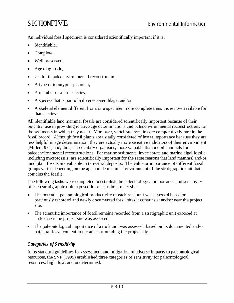
An individual fossil specimen is considered scientifically important if it is:
• Identifiable,
• Complete,
• Well preserved,
• Age diagnostic,
• Useful in paleoenvironmental reconstruction,
• A type or topotypic specimen,
• A member of a rare species,
• A species that is part of a diverse assemblage, and/or
• A skeletal element different from, or a specimen more complete than, those now available for that species.
All identifiable land mammal fossils are considered scientifically important because of their potential use in providing relative age determinations and paleoenvironmental reconstructions for the sediments in which they occur. Moreover, vertebrate remains are comparatively rare in the fossil record. Although fossil plants are usually considered of lesser importance because they are less helpful in age determination, they are actually more sensitive indicators of their environment (Miller 1971) and, thus, as sedentary organisms, more valuable than mobile animals for paleoenvironmental reconstructions. For marine sediments, invertebrate and marine algal fossils, including microfossils, are scientifically important for the same reasons that land mammal and/or land plant fossils are valuable in terrestrial deposits. The value or importance of different fossil groups varies depending on the age and depositional environment of the stratigraphic unit that contains the fossils.
The following tasks were completed to establish the paleontological importance and sensitivity of each stratigraphic unit exposed in or near the project site:
• The potential paleontological productivity of each rock unit was assessed based on previously recorded and newly documented fossil sites it contains at and/or near the project site.
• The scientific importance of fossil remains recorded from a stratigraphic unit exposed at and/or near the project site was assessed.
• The paleontological importance of a rock unit was assessed, based on its documented and/or potential fossil content in the area surrounding the project site.
Categories of Sensitivity In its standard guidelines for assessment and mitigation of adverse impacts to paleontological resources, the SVP (1995) established three categories of sensitivity for paleontological resources: high, low, and undetermined.

SECTIONFIVE Environmental Information
5.8-11
High Sensitivity. Stratigraphic units in which fossils have been previously found have a high potential to produce additional fossils and are therefore considered to be highly sensitive. In the significance criteria of the SVP (1995), all vertebrate fossils are categorized as having significant scientific value and all stratigraphic units in which vertebrate fossils have previously been found have high sensitivity. In areas of high sensitivity, full-time monitoring is recommended during any project-related ground disturbance.
Low Sensitivity. Stratigraphic units that are not sedimentary in origin or that have not been known to produce fossils in the past are considered to have low sensitivity. Monitoring is usually not recommended nor needed during excavation in a stratigraphic unit with low sensitivity.
Undetermined Sensitivity. Stratigraphic units that have not had any previous paleontological resource surveys or any fossil finds are considered to have undetermined sensitivity. After reconnaissance surveys, observation of artificial exposures (such as road cuts) and natural exposures (such as stream banks), and possible subsurface testing (such as augering or trenching), an experienced, professional paleontologist can often determine whether the stratigraphic unit should be categorized as having high or low sensitivity.
5.8.3.5 Resource Inventory Results
Stratigraphic Inventory Regional geologic mapping in the vicinity of the project has been provided by Jennings et al. (1977; 1 to 750,000); Jenkins (1938; 1 to 500,000 scale); Mendenhall et al. (1916; 1 to 500,000), and Matthews and Burnett (1965; 1 to 250,000). Larger scale mapping of the project site has been provided by Page and LeBlanc (1969; 1 to 125,000 scale). Unfortunately, in their geologic maps of the Late Cenozoic deposits of the project area, these geologists have not always used formally named stratigraphic units, nor have they consistently used the same map units.
Piper et al. (1939) published one of the first detailed maps and descriptions of Quaternary sediments in the Central Valley. They lumped all the Pleistocene strata together and named them the “Victor Formation.” Working in Stanislaus and northern Merced counties, Davis and Hall (1959) subdivided Pleistocene sediments equivalent to the “Victor Formation” into the Turlock Lake, Riverbank, and Modesto formations, from oldest to youngest. In 1981, Marchand and Allwardt proposed that the name “Victor Formation” be abandoned and that the Turlock Lake, Riverbank, and Modesto formations be accepted as uniform stratigraphic nomenclature for Quaternary deposits in the area; their recommendations have been followed by most later workers (see for instance Marchand and Allwardt 1978; Bartow and Marchand 1979; Helley and Harwood 1985) and are followed in this report.
Project Geology Matthews and Burnett (1965; 1 to 250,000) mapped the entire project area as “Pleistocene nonmarine sedimentary deposits,” which were interpreted as Riverbank Formation. In the most detailed geologic mapping available of the project site, Page and LeBlanc (1969, 1 to 125,000 scale) mapped the project area as “Older Alluvium,” presumably referring to the Riverbank-Turlock Lake Formations undivided. During the field survey, most sedimentary rocks found

SECTIONFIVE Environmental Information
5.8-12
exposed at or near the surface were semi-consolidated to consolidated reddish-brown siltstones and sandstones with a few thin intervals of brick-red claystone, all lithologies clearly referable to the Riverbank Formation. This unit varies in thickness from zero to eight feet. Stratigraphically below the reddish brown to brick-red beds of the Riverbank Formation are better cemented siltstones and arkosic sandstones which are pinkish tan to brown in color. This underlying unit clearly belongs to the Turlock Lake Formation. No exposures of Modesto Formation were discovered during the field survey. Therefore, because this formation would not be impacted by project construction, it will not be discussed below. Both Riverbank Formation and Turlock Lake Formation would be impacted by Project construction.
Turlock Lake Formation. The Turlock Lake Formation was named by Davis and Hall (1959). The Turlock Lake is composed of interbedded and poorly sorted, brown to tan and gray arkosic siltstones and sandstones with lenses of pebbles and gravels. The sandstone tends to be fine to coarse grained with thicker beds than the siltstones and gravels found elsewhere within the formation. These sediments are poorly cemented with calcareous, siliceous, and/or hematite cements. Locally, tuffaceous units are well cemented so that these beds often form ledges in road cuts, stream banks, and steep slopes. Turlock Lake sediments are primarily alluvial-fluvial (stream) deposits, but marsh-like lacustrine (lake) beds are common where the stream channels merged with standing or slow moving water. The depositional environment of the Turlock Lake Formation has been interpreted to be glacially (climatically) driven where the finer grained, marsh-like, lacustrine deposits dominate the formation (Shlemon 1971). The Turlock Lake Formation is Early Pleistocene in age (700,000 to 500,000 radiocarbon years before present [BP]) based on stratigraphic superposition and age-diagnostic fossils.
Riverbank Formation. The Riverbank Formation was first named by Davis and Hall (1959), who designated a type section along the south bluff of the Stanislaus River within the City of Riverbank. Sedimentary strata referred to the Riverbank Formation are found along the eastern margin of the Central Valley from near Chico in the north to at least Fresno County in the south (Marchand and Allwardt 1981; Helley and Harwood 1985; Marchand 1976b). The Riverbank Formation consists of weakly consolidated reddish-brown to pink siltstones, sandstones, and pebble to cobble conglomerates with a few thin intervals of brick-red claystone. Where exposures were available in the project vicinity, Riverbank sediments consist of predominantly interbedded red to orange siltstones and medium to fine sandstone; coarse sandstones and pebble conglomerates were present but rare. Marchand and Allwardt (1981) placed the age of the Riverbank Formation between 450,000 and 130,000 radiocarbon years BP, Middle Pleistocene.
Paleontological Resource Inventory An inventory of known paleontological resources previously discovered in the vicinity of the project is presented below and the paleontological importance of these resources is assessed. The literature review and UCMP archival search conducted for this inventory documented no previously recorded fossil sites within the actual project site or on the ROW of proposed linear facilities. However, sediments of the Turlock Lake and Riverbank Formations have yielded fossilized remains of extinct species of continental vertebrates and other types of fossils at numerous previously recorded fossil sites in the Central Valley (Fisk 2000, 2001a). In addition, fossil remains were found at previously unrecorded fossil sites during the field survey of the project and vicinity conducted for this assessment.

SECTIONFIVE Environmental Information
5.8-13
Turlock Lake Formation. The Turlock Lake has yielded fossil remains at numerous sites in the Central Valley. These remains include petrified wood and the bones and teeth of a diversity of extinct land mammals. Hay (1927) reported teeth and bones of mammoths, bones of horses, and a tooth of a camel from sediments that Piper et al. (1939) interpreted as probably equivalent to the Turlock Lake Formation. Both vertebrate and plant fossils have also been reported from the bluffs along the American River at Fair Oaks (UCMP records and personal observations). Fisk and Butler (2005) reported fossil fish, plant fragments, petrified wood, and ichnofossils in Turlock Lake Formation near Roseville. Dundas (1994), Dundas et al. (1996), and Dundas and Blades (1999) described a large fauna from the Turlock Lake Formation at the Fairmead Landfill site, located approximately 30 miles (14.5 kilometers) northwest of Fresno.
Since fossil vertebrates have been previously reported from the Turlock Lake Formation and since depositional conditions observed in exposures in the vicinity of the project appear to be favorable for the preservation of fossils, the Turlock Lake Formation is judged to have high sensitivity. There is a high probability of adverse impacts on paleontological resources resulting from ground disturbance during project excavations in sediments of the Turlock Lake Formation. In addition, during a field survey of prospective fossiliferous sediments in the project vicinity, although very limited exposures of Turlock Lake Formation sediments were discovered, a paleosol (fossil soil) was observed at the top of the Turlock Formation at several localities. Within the paleosol, ichnofossils (burrow and root casts and molds) and fossil leaf impressions were observed.
Riverbank Formation. Sediments of the Riverbank Formation have yielded the fossilized remains of Late Pleistocene plants and animals from numerous previously recorded fossil sites in the Central Valley (Fisk 2000). Fossil vertebrates of Irvingtonian to Rancholabrean land-mammal age have been reported from Riverbank Formation sediments near their type area (Garber 1989, Jefferson 1991) and at numerous other scattered locations along the eastern margin of the Central Valley (Fisk and Lander 1999; Lander 1999; Fisk 2000, 2001a, 2001b). Fossils previously reported from the Riverbank Formation include clams, fish, turtles, frogs, snakes, birds, bison, mammoths, mastodons, ground sloths, camels, horses, pronghorns, deer, dire wolves, coyotes, rabbits, rodents, and land plant remains (including wood, leaves, and seeds).
Hilton et al. (2000) described a large fossil fauna from the Riverbank Formation discovered in a paleosol during excavations for the Arco Arena in Sacramento. During excavations in Riverbank Formation for the construction of a power plant in south Sacramento, a paleosol horizon was discovered in the Riverbank Formation. This paleosol contained unidentifiable ichnofossils, including root and burrow molds and casts (Fisk 2001a). The presence of this paleosol and others in the Riverbank Formation indicates that scientifically important fossil specimens may be discovered from paleosol horizons in the Riverbank Formation. Excavations for the Fairmead Landfill have exposed fossiliferous sediments of both the Riverbank and Turlock Lake Formations and significant vertebrate fossils have come from both stratigraphic units (Dundas et al. 2000; UCMP records; Phil Peck personal communication 2006).
These fossil remains previously recovered from the Riverbank Formation are scientifically significant because the taxa they represent had been previously unreported or only very rarely reported from the fossil record of California. Moreover, continental vertebrate remains are comparatively rare in the fossil record. In addition, paleontological data derived from a study of the fossil remains, in conjunction with geologic (particularly geochronologic, sedimentologic, and paleomagnetic) evidence, have been significant in documenting the origin and age of the

SECTIONFIVE Environmental Information
5.8-14
Riverbank Formation and in reconstructing the Pleistocene geologic history of the Central Valley and foothills of the Sierra Nevada.
Since fossils have been previously reported from the Riverbank Formation and since depositional conditions observed in exposures in the vicinity of the project appear to be favorable for the preservation of fossils, the Riverbank Formation is judged to also have high sensitivity. During a field survey of prospective fossiliferous sediments in the project vicinity on September 1 and 2, and September 29 and 30, 2006, fossils were observed at only one exposure of the Riverbank Formation. Therefore, there is a low probability of adverse impacts on paleontological resources in the Riverbank Formation.
Summary Although no fossils are known to directly underlie the project, the presence of fossil sites in alluvial deposits of the Turlock Lake and Riverbank Formations elsewhere suggests that there is a potential for additional similar fossil remains to be uncovered by excavations in these formations during project construction. Under SVP (1995) criteria, both these formations have a high sensitivity for producing additional paleontological resources. Identifiable fossil remains recovered from these formations during project construction could be scientifically important and significant.
Identifiable fossil remains recovered during project construction could represent new taxa or new fossil records for the area, for the State of California, or for a formation. They could also represent geographic or temporal range extensions. Moreover, discovered fossil remains could make it possible to more accurately determine the age, paleoclimate, and depositional environment of the sediments from which they are recovered. Finally, fossil remains recovered during project construction could provide a more comprehensive documentation of the diversity of animal and plant life that once existed in Fresno County and could result in a more accurate reconstruction of the geologic and paleobiologic history of the Central Valley and foothills of the Sierra Nevada.
5.8.4 Environmental Consequences
5.8.4.1 Potential Impacts from Project Construction
Potential impacts on paleontological resources resulting from construction of the project primarily involve terrain modification (excavations and drainage diversion measures). Paleontologic resources that could be adversely impacted by ground disturbance and earth moving include an undetermined number of fossil remains and unrecorded fossil sites, associated specimen data and corresponding geologic and geographic site data, and the fossil-bearing strata. Direct impacts could result from vegetation clearing, grading, widening of road cuts, and any other earth-moving activity that disturb or bury previously undisturbed fossiliferous sediments, making those sediments and their paleontological resources unavailable for future scientific investigation.
The planned site clearing, grading, and deeper excavation at the site could result in significant adverse impacts to paleontological resources. In addition, the construction of supporting facilities, such as temporary construction offices, laydown yards, and parking areas, have

SECTIONFIVE Environmental Information
5.8-15
potential to cause adverse impacts on significant paleontological resources, as they also will involve extensive new ground disturbance. Thus, any project-related ground disturbance could have adverse impacts on significant paleontological resources. However, with a properly designed and implemented mitigation program, these impacts would be reduced to less than significant.
5.8.4.2 Potential Impacts from Project Operation
No impacts on paleontological resources are expected to occur from the continuing operation of the project or any of its related facilities.
5.8.5 Cumulative Impacts If the project were to encounter paleontological finds during construction, the potential cumulative impacts would be low, as long as mitigation measures were implemented to recover the resources. The mitigation measures proposed in Section 5.8.6, Mitigation Measures, would effectively recover the value to science of any significant fossils uncovered during project-related excavations.
5.8.6 Mitigation Measures This section describes proposed mitigation measures that would be implemented to reduce potential adverse impacts to significant paleontological resources resulting from project construction. Mitigation measures are necessary because of potential adverse impacts of project construction on significant paleontological resources within the Turlock Lake and Riverbank Formations. The proposed paleontological resource impact mitigation program would reduce to an insignificant level the direct, indirect, and cumulative adverse environmental impacts on paleontological resources that could result from project construction. The mitigation measures proposed below are consistent with SVP standard guidelines for mitigating adverse construction-related impacts on paleontological resources (SVP 1995, 1996).
Prior to construction, a qualified paleontologist should be retained to both design a monitoring and mitigation program and implement the program during all project-related ground disturbance. The paleontological resource monitoring and mitigation program should include:
• preconstruction coordination;
• construction monitoring;
• emergency discovery procedures;
• sampling and data recovery, if needed;
• preparation, identification, and analysis of the significance of fossil specimens salvaged, if any;
• museum storage of any specimens and data recovered; and
• reporting.
Prior to the start of construction, the paleontologist should conduct a field survey of exposures of sensitive stratigraphic units that will be disturbed. Earth moving construction activities should

SECTIONFIVE Environmental Information
5.8-16
be monitored wherever these activities will disturb previously undisturbed sediment. Monitoring will not need to be conducted in areas where sediments have been previously disturbed or in areas where exposed sediments will be buried, but not otherwise disturbed.
Prior to the start of construction, construction personnel involved with earth-moving activities should be informed that fossils may be discovered during excavating, that these fossils are protected by laws, on the appearance of common fossils, and on proper notification procedures. This worker training should be prepared and presented by a qualified paleontologist.
Implementation of these mitigation measures will reduce the potentially significant adverse environmental impact of project-related ground disturbance and earth moving on paleontological resources to an insignificant level by allowing for the recovery of fossil remains and associated specimen data and corresponding geologic and geographic site data that otherwise might be lost to earth moving and to unauthorized fossil collecting.
With a well designed and implemented paleontological resource monitoring and mitigation plan, project construction could actually result in beneficial effects on paleontological resources through the discovery of fossil remains that would not have been exposed without project construction and, therefore, would not have been available for study. The recovery of fossil remains as part of project construction could help answer important questions regarding the geographic distribution, stratigraphic position, and age of fossiliferous sediments in the project area.
5.8.7 Involved Agencies and Agency Contacts No state or local agencies have specific jurisdiction over paleontological resources. If federally owned or managed lands would be impacted by this project, the Bureau of Land Management (BLM) would need to be involved.
5.8.8 Permits Required and Permit Schedule No state or county agency requires a paleontological collecting permit to allow for the recovery of fossil remains discovered as a result of construction-related earth moving on state or private land in a project site. Removal of paleontological resources from federal lands requires a Paleontological Resource Use Permit from the BLM. If federally owned or managed lands will be impacted by this project, the paleontologist hired to manage the paleontological resource monitoring and mitigation program will need to have a current Paleontological Resource Use Permit, as well as fieldwork authorization from the local BLM office. Obtaining these permits could take up to 6 months.
5.8.9 References Arkley, R.J. 1962. The geology, geomorphology, and soils of the San Joaquin Valley in the
vicinity of the Merced River, California: California Division of Mines and Geology Bulletin 182, p. 25-31.
Arkley, R.J. 1964. Soil survey of the eastern Stanislaus area, California: U.S. Department of Agriculture, Soil Conservation Service, 160 p.

SECTIONFIVE Environmental Information
5.8-17
Atwater, B.F. 1980. Attempts to correlate Late Quaternary climatic records between San Francisco Bay, the Sacramento-San Joaquin Delta, and the Mokelumne River, California: unpublished PhD dissertation, University of Delaware, Newark, DE, 214 p.
Bartow, J.A., and D.E. Marchand. 1979. Preliminary geologic map of Cenozoic deposits of the Clay area, California: U.S. Geological Survey Open-File Report 79-667, (scale 1 to 62,500).
Bartow, J.A. 1987. The Cenozoic evolution of the San Joaquin Valley, California: U. S. Geological Survey, Open-File Report OF-87-581, scale 1:500,000.
Bartow, J.A. 1991. The Cenozoic evolution of the San Joaquin Valley, California: U.S. Geological Survey Professional Paper 1501, 40 p., scale 1 to 500,000.
Bennett, G.L., G.S. Weissmann, G.S. Baker, and D.W. Hyndman. 2006. Regional-scale assessment of a sequence-bounding paleosol on fluvial fans using ground-penetrating radar, eastern San Joaquin Valley, California: Geological Society of America Bulletin, vol. 118, no. 5/6 p. 724-732.
Beyer, L.A., and A. Bartow. 1988. Summary of geology and petroleum plays to assess undiscovered recoverable petroleum resources, San Joaquin basin province, California: U.S. Geological Survey Open-File Report OF-87-450-Z, 80 p., scale 1 to 500,000.
Bull, W.B. 1973. Geologic factors affecting compaction of deposits in a land-subsidence area [Fresno, Kings, and Merced counties, California]: Geological Society of America Bulletin, vol. 84, no. 12, p. 3783-3802.
California Energy Commission. 2000. Paleontological resources: in Regulations pertaining to the rules of practice and procedure & generating facility site certification, 3 p.
California State Historic Preservation Office. 1983. Summary of state/federal laws protecting cultural resources: California State Historic Preservation Office, Sacramento, CA, 4 p.
Callaway, D.C., and E.W. Rennie. 1991. San Joaquin basin, California: Geological Society of America, The Geology of North America, vol. P-2, Chapter 26, p. 417-430.
Cehrs, D. 1979. Depositional control of aquifer characteristics in alluvial fans, Fresno County, California: Geological Society of America Bulletin, vol. 90, Part II, p. 1282-1309.
Clark, B.L. 1929. Tectonics of the Valle Grande of California: American Association of Petroleum Geologists Bulletin, vol. 13, p. 199-238.
Clark, L.D. 1964. Stratigraphy and structure of part of the western Sierra Nevada metamorphic belt, California: U.S. Geological Survey Professional Paper 410, 70 p.
Cole, J.W., and D.R. Fuller. 1988. Mineral land classification – aggregate materials in the Fresno production-consumption region: California Division of Mines and Geology Special Report 158, 21 p.
Croft, M. G., and C. Wahrhaftig. 1965. General geology of the San Joaquin Valley: International Association of Quaternary Research, 7th Congress Guidebook, Field Conference I, Northern Great Basin and California, Nebraska Academy of Sciences, Lincoln, p. 133-137.

SECTIONFIVE Environmental Information
5.8-18
Davis, G.H., J.H. Green, F.H. Olmsted, and D.W. Brown. 1957. Groundwater conditions and storage capacity in the San Joaquin Valley, California: U.S. Geological Survey Open-File Report, 559 p.
Davis, G.H., J.H. Green, F.H. Olmsted, and D.W. Brown. 1959. Ground-water conditions and storage capacity in the San Joaquin Valley, California: U.S. Geological Survey Water-Supply Paper 1469, 287 p.
Davis, G.H. and C.A. Hall, Jr. 1959. Water quality of eastern Stanislaus and northern Merced counties, California: University of California Publications in Geological Sciences, vol. 6, no. 1, p. 1-56.
Davis, G.H., B.E. Lofgren, and S. Mack. 1964. Use of ground-water reservoirs for storage of surface water in the San Joaquin Valley, California: U.S. Geological Survey Water-Supply Paper 1618, 125 p.
Dundas, R.G. 1994. The Fairmead landfill locality; a late Irvingtonian fauna from western Madera County, California: Geological Society of America Abstracts with Programs, vol. 26, no. 2, p. 49.
Dundas, R.G. 2002. Route 189 (Fresno County, California) assessment report on paleontological sensitivity: unpublished report prepared for California Department of Transportation, District 06, Fresno, CA, 5 p.
Dundas, R.G. and D.L. Blades. 1999. The Fairmead landfill locality (Pleistocene, Irvingtonian), Madera County: Geological Society of America Abstracts with Programs, vol. 31, no. 7, p. 465.
Dundas, R G., R.B. Smith, and K.L. Verosub. 1996. The Fairmead Landfill Locality (Pleistocene, Irvingtonian), Madera County, California: Preliminary report and significance: Paleobios, vol. 17, p. 50-58.
Dundas, R.G. 2002. Route 189 (Fresno County, California) assessment report on paleontological sensitivity: unpublished report prepared for California Department of Transportation, District 06, Fresno, CA, 5 p.
Fenneman, N.M. 1931. Physiography of western United States: McGraw-Hill Book Company, New York, NY, 534 p.
Fisk, L.H. 2000. Reassessment of the potential environmental consequences of construction of the SMUD SCA Peaker Project on paleontological resources: unpublished report prepared for the Sacramento Municipal Utility District and EA Engineering, Science, and Technology, Inc., by PaleoResource Consultants, Sacramento, CA, 10 p.
Fisk, L.H. 2001a. Final report on the paleontological resource impact mitigation program for the Sacramento Municipal Utility District Sacramento Cogeneration Authority peaker project: unpublished report prepared for the Sacramento Municipal Utility District and EA Engineering, Science, and Technology, Inc., by PaleoResource Consultants, Sacramento, CA, 38 p.

SECTIONFIVE Environmental Information
5.8-19
Fisk, L.H. 2001b. Cosumnes Power Plant Project Application for Certification Paleontological Resource Section: Report prepared for the California Energy Commission, CH2M Hill Corporation, and Sacramento Municipal Utility District, by PaleoResource Consultants, Sacramento, CA, 29 p.
Fisk, L.H. 2006. Paleontological resource impact assessment, Ellis Street Overcrossing Project in the City and County of Madera, California: unpublished report prepared for the City of Madera, CA, and Valley Planning Consultants, Madera, CA, by PaleoResource Consultants, Sacramento, CA, 44 p.
Fisk, L.H. and T.M. Butler. 2005. Brookwood Subdivision Project Paleontological Resource Impact Assessment: Report prepared for ECORP Consulting and Placer County Planning Department, by PaleoResource Consultants, Sacramento, CA, 23 p.
Fisk, L.H. and E.B. Lander. 1999. Sutter Power Plant Project worker/employee environmental awareness training program for paleontologic resources: unpublished report prepared for Calpine Corporation and the California Energy Commission by Paleo Environmental Associates, Inc., Altadena, CA, 10 p.
Fisk, L.H. and D.F. Maloney. 2004. Woodland Generation Station Unit 2 Project final report on the results of the paleontological resource monitoring and mitigation program: unpublished report prepared for CH2M Hill Corporation, Modesto Irrigation District, and California Energy Commission by PaleoResource Consultants, Sacramento, CA, 112 p.
Fisk, L.H. and L.A. Spencer. 1994. Highway construction projects have legal mandates requiring protection of paleontologic resources (fossils): p. 213-225, in: Scott F. Burns (editor), Proceedings of the 45th Highway Geology Symposium, Portland, OR, 258 p.
Fisk, L.H., L.A. Spencer, and D.P. Whistler. 1994. Paleontologic resource impact mitigation on the PGT-PG&E Pipeline Expansion Project, Volume II: PG&E Section, California: unpublished report prepared for the Federal Energy Regulatory Commission, California Public Utilities Commission, Pacific Gas and Electric Company, and Bechtel Corporation by Paleo Environmental Associates, Inc., Altadena, CA, 123 p.
Garber, D.C. 1989. Natural radionuclides in the soil and bones with age dating of Rancho-labrean faunas and archaeological sites: University of California Department of Land, Air and Water Resources Special Report.
Gastaldo, R.A. 1999. International laws: collecting, transporting and ownership of fossils – USA: p. 330-338 in T.P. Jones and N.P. Rowe (editors), Fossil plants and spores, The Geological Society, London, England, 396 p.
Grunsky, C.E. 1898. Irrigation near Fresno, California: U.S. Geological Survey Water-Supply Paper 18, 94 p.
Hackel, O. 1966. Summary of the geology of the Great Valley, p. 217-238, in E.H. Bailey (editor), Geology of Northern California: California Division of Mines and Geology Bulletin 190, 508 p.
Hall, C.A., Jr. 1958. Geology and paleontology of the Pleasanton area, Alameda and Contra Costa Counties, California: University of California Publications in Geological Sciences, vol. 34, no. 1, p. 1-90.

SECTIONFIVE Environmental Information
5.8-20
Hay, O.P. 1927. The Pleistocene of the western region of North America and its vertebrate animals: Carnegie Institute of Washington Publication 322(B), 346 p.
Helley, E. J. and D.S. Harwood. 1985. Geologic map of the Late Cenozoic deposits of the Sacramento Valley and northern Sierran foothills, California: U. S. Geological Survey Miscellaneous Field Studies Map MF-1790, 24 p., (1:62,500 scale).
Hilton, R.P., D.C. Dailey, and H.G. McDonald. 2000. A late Pleistocene biota from the ARCO Arena site, Sacramento, California: PaleoBios, vol. 20, no. 1, p. 7-12.
Hoffman, R.D. 1964. Geology of the northern San Joaquin Valley: San Joaquin Geological Society Selected Papers, vol. 2, p. 30-45.
Hoots, H.W., T.L. Bear, and W.D. Kleinpell. 1954. Geological summary of the San Joaquin Valley, California, p. 113-129, in Jahns, R. H. (editor), Geology of southern California: California Division of Mines Bulletin 170, 289 p.
Huntington, G.L. 1971. Soil survey, eastern Fresno area, California: U. S. Department of Agriculture Soil Conservation Service, U. S. Government Printing Office, Washington, DC, 323 p.
Huntington, G.L. 1980. Soil-land form relationships of portions of the San Joaquin River and Kings River alluvial depositional systems in the Great Valley of California: unpublished PhD dissertation, University of California at Davis, Davis, CA, 246 p.
Jahns, R.H. (editor). 1954. Geology of Southern California: California Division of Mines Bulletin 170, 289 p.
Janda, R.J. 1966. Pleistocene history and hydrology of the upper San Joaquin River, California: unpublished PhD dissertation, University of California, Berkeley, CA, 425 p.
Janda, R.J. and M.G. Croft. 1965. The stratigraphic significance of a sequence of noncalcic brown soils formed on the Quaternary alluvium of the northeastern San Joaquin Valley, California: International Association for Quaternary Research Proceedings, vol. 9, p. 158-190.
Jefferson, G.T. 1991a. A catalogue of Late Quaternary Vertebrates from California, Part One, Non-Marine Lower Vertebrate and Avaian Taxa: Natural History Museum of Los Angeles County Technical Reports, No. 5, 60 p. 1991.
Jefferson, G.T. 1991b. A Catalogue of Late Quaternary Vertebrates from California, Part Two, Mammals: Natural History Museum of Los Angeles County Technical Reports, Number 7, 129 p.
Jenkins, O.P. 1938. Geologic map of California: California Division of Mines and Geology, Sacramento, CA (1 to 500,000 scale).
Jennings, C.W., R.G. Strand, T.H. Rogers, R.T. Boylan, R.R. Moar, and R.A. Switzer. 1977. Geologic map of California: California Division of Mines and Geology, Geologic Data Map 2, scale 1 to 750,000.
Lettis, W.R. 1988. Quaternary geology of the northern San Joaquin Valley: p. 333-351 in Graham, S.A., editor, Studies of the geology of the San Joaquin Basin, Pacific Section, Society of Economic Paleontologists and Mineralogists, vol. 60, 351 p.

SECTIONFIVE Environmental Information
5.8-21
Lettis, W.R., and J.R. Unruh. 1991. Quaternary geology of the Great Valley, California: p. 164-176 in Dupré, W.R. and others, Quaternary geology of the Pacific margin, p. 141-213 in Morrison, R.B., editor, Quaternary nonglacial geology – conterminous U.S., Geological Society of America, Geology of North America, vol. K-2, 672 p.
Lander, E.B. 1989. Interim paleontological resource technical report, Eastside Reservoir Project Study – Phase 1, Riverside County, California: unpublished report prepared for Metropolitan Water District of Southern California by Paleo Environmental Associates, Inc., Altadena, CA, 20 p.
Lander, E.B. 1993. Paleontologic/cultural resource impact mitigation program final report: unpublished report prepared for Midway Sunset Cogeneration Company, Mojave Natural Gas Pipeline, and Kern County, California by Paleo Environmental Associates, Inc., Altadena, CA, 57 p.
Lander, E.B. 1999. Sutter Power Plant project paleontologic resource monitoring and mitigation plan: unpublished report prepared for Calpine Corporation by Paleo Environmental Associates, Inc., Altadena, CA, 10 p.
Maher, J.C., W.M. Trollman, and J.M. Denman. 1973. Geological literature on the San Joaquin Valley of California: Northern California Geological Society and Pacific Section of the American Association of Petroleum Geologists, Sacramento, CA, 582 p.
Marchand, D.E. 1976a. Preliminary Quaternary geologic map of the Merced area, California: U.S. Geological Survey Open-file Report 76-837, scale 1 to 24,000.
Marchand, D.E. 1976b. Preliminary geologic maps showing Quaternary deposits of the Madera area, (Poso Farm, Firebaugh NE, Bonita Ranch, Madera, Gregg, Lanes Bridge, Friant, and Academy 7-1/2' quadrangles), eastern San Joaquin Valley, Madera and Fresno counties, California: U.S. Geological Survey Open-File Report OF-76-841, scale 1 to 24,000.
Marchand, D.E. 1977. The Cenozoic history of the San Joaquin Valley and the Adjacent Sierra Nevada as Inferred From The Geology And Soils Of The Eastern San Joaquin Valley, p. 39-50, in M. J. Singer (editor), Soil Development, Geomorphology, and Cenozoic History of the Northeastern San Joaquin Valley and Adjacent Areas, California: University of California Press, Guidebook for Joint Field Session, Soil Science Society of America and Geological Society of America, 328 p.
Marchand, D.E. and A. Allwardt. 1978. Preliminary Geologic Map Showing Quaternary Deposits of the Northeastern San Joaquin Valley, California: U. S. Geological Survey, Miscellaneous Field Studies Map MF-945, scale 1:125,000.
Marchand, D.E. and A. Allwardt. 1981. Late Cenozoic stratigraphic units, northeastern San Joaquin Valley, California: U.S. Geological Survey Bulletin 1470, 70 p.
Marshall, L.G. 1976. Paleontological salvage and federal legislation: Journal of Paleontology, vol. 50, p. 346-348.
Matthews, R.A. and J.L. Burnett. 1965. Geologic map of California -- Fresno sheet: California Division of Mines and Geology, scale 1 to 250,000.
SECTIONFIVE Environmental Information
5.8-22
Mendenhall, W.C. 1908. Preliminary report on the ground waters of San Joaquin Valley, California: U.S. Geological Survey Water-Supply Paper 222, 52 p.
Mendenhall, W.C., R.B. Dole, and H. Stabler. 1916. Ground water in San Joaquin Valley, California: U.S. Geological Survey Water-Supply Paper 398, 310 p., scale 1 to 500,000.
Miller, W.E. 1971. Pleistocene vertebrates of the Los Angeles Basin and Vicinity (exclusive of Rancho La Brea): Bulletin of the Los Angeles County Museum of Natural History, No. 10, 124 p.
Mitten, H.T. 1984. Ground water in the Fresno area, California: U.S. Geological Survey Water Resources Investigations Report 83-4246, 15 p.
Muir, K.S. 1977. Ground water in the Fresno area, California: U.S. Geological Survey Water-Resources Investigations Report 77-59, 22 p.
Oltmann, R.N. and M.V. Shulters. 1989. Rainfall and runoff quantity and quality characteristics of four urban land-use catchments in Fresno, California, October 1981 to April 1983: U.S. Geological Survey Water-Supply Paper 2335, 114 p., scale 1 to 87,000.
Page, R.W. 1973. Base of Fresh Ground water (approximately 3,000 micromhos) in the San Joaquin Valley, California: U. S. Geological Survey Hydrologic Investigations Atlas HA-489, scale 1:500,000.
_______. 1986. Geology of the fresh ground-water basin of the Central Valley, California, with texture maps and sections: U.S. Geological Survey Professional Paper 1401-C, scale 1 to 500,000.
Page, R.W. and R.A. LeBlanc. 1969. Geology, hydrology, and water quality in the Fresno area, California: U.S. Geological Survey, Open-File Report OF-69-328, 70 p., scale 1 to 126,720.
Peck, Phil. 2006. Personal communication.
Piper, A.M., H.S. Gale, H.E. Thomas, and T.W. Robinson. 1939. Geology and ground-water hydrology of the Mokelumne area, California: U.S. Geological Survey Water-Supply Paper 780, 230 p.
Reynolds, R.E. 1987. Paleontologic resource assessment, Midway-Sunset Cogeneration Project, Kern County, California: unpublished report prepared for Southern California Edison Company by San Bernardino County Museum, San Bernardino, CA, 15 p.
Reynolds, R.E. 1990. Paleontological mitigation program, Midway-Sunset Cogeneration Project, Kern County, California: unpublished report prepared for Midway-Sunset Cogeneration Company, by San Bernardino County Museum, San Bernardino, CA, 45 p.
Rogers, T.H. 1966. Geologic map of California, San Jose Sheet: California Division of Mines and Geology, Sacramento, CA, (1 to 250,000 scale).
Savage, D.E. 1951. Late Cenozoic vertebrates of the San Francisco Bay region: University of California Publications, Bulletin of the Department of Geological Sciences, vol. 28, no. 10, p. 215-314.

SECTIONFIVE Environmental Information
5.8-23
Shipman, P. 1977. Paleoecology, taphonomic history and population dynamics of the vertebrate assemblage from the middle Miocene of Fort Turnan, Kenya: unpublished Ph.D. Dissertation, New York University, NY, 193 p.
Shipman, P. 1981. Spatial distribution of fossils in sediments, p. 65-98, in P. Shipman, Life history of a fossil, an introduction to taphonomy and paleoecology: Harvard University Press, Cambridge, MA, 222 p.
Shlemon, R.J. 1967a. Landform-soil relationships in northern Sacramento County, California: unpublished PhD dissertation, University of California, Berkeley, CA, 335 p.
Shlemon, R.J. 1967b. Quaternary geology of northern Sacramento County, California: Annual Field Trip Guidebook of the Geological Society of Sacramento, Sacramento, CA, 60 p.
Shlemon, R.J. 1971. The Quaternary Deltaic and Channel System in the Central Great Valley, California: Annals of the Association of American Geographers, vol. 61, No. 3, p. 427-440.
Shlemon, R.J. 1972. The lower American River area, California – a model of Pleistocene landscape evolution: Yearbook of the Association of Pacific Coast Geographers, vol. 34, p. 61-86.
Society of Vertebrate Paleontology. 1995. Assessment and mitigation of adverse impacts to nonrenewable paleontologic resources – standard guidelines: Society of Vertebrate Paleontology News Bulletin, vol. 163, p. 22-27.
Society of Vertebrate Paleontology. 1996. Conditions of receivership for paleontologic salvage collections: Society of Vertebrate Paleontology News Bulletin, vol. 166, p. 31-32.
Spencer, L.A. 1990. Paleontological mitigation program, Midway-Sunset Cogeneration Project, Natural Gas Pipeline, Kern County, California: unpublished report prepared for Midway-Sunset Cogeneration Company by Paleo Environmental Associates, Inc., Altadena, CA, 12 p.
Taliaferro, N.L. 1951. Geology of the San Francisco Bay counties: California Division of Mines Bulletin 154, p. 117-150.
Wagner, D.L., E.J. Bortugno, and R.D. McJunkin. 1990. Geologic map of the San Francisco-San Jose quadrangle: California Division of Mines and Geology Regional Geologic Map Series (1 to 250,000 scale).
Wahrhaftig, C., S.W. Stine, and N.K. Huber. 1993. Quaternary geologic map of the San Francisco Bay 4o x 6o Quadrangle, United States: U.S. Geological Survey Miscellaneous Investigations Map I-1420 (1 to 1,000,000 scale).
Weissman, G.S., J.F. Mount, and G.E. Fogg. 2002. Glacially driven cycles in accumulation space and sequence stratigraphy of a stream-dominated alluvial fan, San Joaquin Valley, California, U.S.A.: Journal of Sedimentary Research, vol. 72, no. 2, p. 240-251.
West, R.M. 1991. State regulation of geological, paleontological, and archaeological collecting: Curator, vol. 34, p. 199-209.


Ade
quac
y Is
sue:
A
dequ
ate
In
adeq
uate
DA
TA
AD
EQ
UA
CY
WO
RK
SH
EE
T
Rev
isio
n N
o.
0 D
ate
Tech
nica
l A
rea:
Pa
leon
tolo
gica
l Res
ourc
es
Pro
ject
: P
EC
Te
chni
cal S
taff:
Proj
ect
Man
ager
:
Doc
ket:
Te
chni
cal S
enio
r:
SITI
NG
R
EGU
LATI
ON
S IN
FOR
MA
TIO
N
AFC
PA
GE
NU
MB
ER A
ND
SE
CTI
ON
NU
MB
ER
AD
EQU
ATE
Y ES
OR
NO
INFO
RM
ATI
ON
REQ
UIR
ED T
O M
AK
E A
FC C
ON
FOR
M
WIT
H R
EGU
LATI
ON
S
App
endi
x B
(g
) (1)
...
prov
ide
a di
scus
sion
of t
he e
xist
ing
site
co
nditi
ons,
the
expe
cted
dire
ct, i
ndire
ct a
nd
cum
ulat
ive
impa
cts
due
to th
e co
nstru
ctio
n,
oper
atio
n an
d m
aint
enan
ce o
f the
pro
ject
, the
m
easu
res
prop
osed
to m
itiga
te a
dver
se
envi
ronm
enta
l im
pact
s of
the
proj
ect,
the
effe
ctiv
enes
s of
the
prop
osed
mea
sure
s, a
nd
any
mon
itorin
g pl
ans
prop
osed
to v
erify
the
effe
ctiv
enes
s of
the
miti
gatio
n.
5.8.
1 5.
8.2
5.8.
3 5.
8.4
5.8.
5 A
ppen
dix
K
App
endi
x B
(g
) (16
) (A
)
Iden
tific
atio
n of
the
phys
iogr
aphi
c pr
ovin
ce a
nd
a br
ief s
umm
ary
of th
e ge
olog
ic s
ettin
g,
form
atio
ns, a
nd s
tratig
raph
y of
the
proj
ect a
rea.
Th
e ar
ea m
ay v
ary
depe
ndin
g on
the
depo
sitio
nal h
isto
ry o
f the
are
a.
5.8.
3.1
5.8.
3.2
App
endi
x K
App
endi
x B
(g
) (16
) (B
) A
dis
cuss
ion
of th
e se
nsiti
vity
of t
he p
roje
ct
area
des
crib
ed in
sub
sect
ion
(g)(
16)(
A) a
nd th
e pr
esen
ce a
nd s
igni
fican
ce o
f any
kno
wn
pale
onto
logi
c lo
calit
ies
or o
ther
pal
eont
olog
ic
reso
urce
s w
ithin
or a
djac
ent t
o th
e pr
ojec
t.
5.8.
2 5.
8.3
App
endi
x K
App
endi
x B
(g
) (16
) (C
) A
sum
mar
y of
all
liter
atur
e se
arch
es a
nd fi
eld
surv
eys
used
to p
rovi
de in
form
atio
n ab
out
pale
onto
logi
c re
sour
ces
in th
e pr
ojec
t are
a de
scrib
ed in
sub
sect
ion
(g)(1
6)(A
). Id
entif
y th
e da
tes
of th
e su
rvey
s, m
etho
ds u
sed
in
com
plet
ing
the
surv
eys,
and
the
nam
es a
nd
qual
ifica
tions
of t
he in
divi
dual
s co
nduc
ting
the
surv
eys.
5.8.
2 A
ppen
dix
K

Ade
quac
y Is
sue:
A
dequ
ate
In
adeq
uate
DA
TA
AD
EQ
UA
CY
WO
RK
SH
EE
T
Rev
isio
n N
o.
0 D
ate
Tech
nica
l A
rea:
Pa
leon
tolo
gica
l Res
ourc
es
Pro
ject
: P
EC
Te
chni
cal S
taff:
Proj
ect
Man
ager
:
Doc
ket:
Te
chni
cal S
enio
r:
SITI
NG
R
EGU
LATI
ON
S IN
FOR
MA
TIO
N
AFC
PA
GE
NU
MB
ER A
ND
SE
CTI
ON
NU
MB
ER
AD
EQU
ATE
Y ES
OR
NO
INFO
RM
ATI
ON
REQ
UIR
ED T
O M
AK
E A
FC C
ON
FOR
M
WIT
H R
EGU
LATI
ON
S
App
endi
x B
(g
) (16
) (D
) In
form
atio
n on
the
spec
ific
loca
tion
of k
now
n pa
leon
tolo
gic
reso
urce
s, s
urve
y re
ports
, loc
ality
re
cord
s, a
nd m
aps
at a
sca
le o
f 1:2
4,00
0, s
hall
be in
clud
ed in
a s
epar
ate
appe
ndix
to th
e A
pplic
atio
n an
d su
bmitt
ed to
the
Com
mis
sion
un
der a
requ
est f
or c
onfid
entia
lity,
pur
suan
t to
Title
20,
Cal
iforn
ia C
ode
of R
egul
atio
ns, §
250
1 et
seq
.
App
endi
x K
App
endi
x B
(g
) (16
) (E
) A
dis
cuss
ion
of a
ny e
duca
tiona
l pro
gram
s pr
opos
ed to
enh
ance
aw
aren
ess
of p
oten
tial
impa
cts
to p
aleo
ntol
ogic
al re
sour
ces
by
empl
oyee
s, m
easu
res
prop
osed
for m
itiga
tion
of im
pact
s to
kno
wn
pale
onto
logi
c re
sour
ces,
an
d a
set o
f con
tinge
ncy
mea
sure
s fo
r m
itiga
tion
of p
oten
tial i
mpa
cts
to c
urre
ntly
un
know
n pa
leon
tolo
gic
reso
urce
s.
5.8.
5
App
endi
x B
(h
) (1)
(A)
Tabl
es w
hich
iden
tify
law
s, re
gula
tions
, or
dina
nces
, sta
ndar
ds, a
dopt
ed lo
cal,
regi
onal
, st
ate,
and
fede
ral l
and
use
plan
s, a
nd p
erm
its
appl
icab
le to
the
prop
osed
pro
ject
, and
a
disc
ussi
on o
f the
app
licab
ility
of e
ach.
The
ta
ble
or m
atrix
sha
ll ex
plic
itly
refe
renc
e pa
ges
in
the
appl
icat
ion
whe
rein
con
form
ance
, with
eac
h la
w o
r sta
ndar
d du
ring
both
con
stru
ctio
n an
d op
erat
ion
of th
e fa
cilit
y is
dis
cuss
ed;
5.8.
7 Ta
ble
5.8-
1

Ade
quac
y Is
sue:
A
dequ
ate
In
adeq
uate
DA
TA
AD
EQ
UA
CY
WO
RK
SH
EE
T
Rev
isio
n N
o.
0 D
ate
Tech
nica
l A
rea:
Pa
leon
tolo
gica
l Res
ourc
es
Pro
ject
: P
EC
Te
chni
cal S
taff:
Proj
ect
Man
ager
:
Doc
ket:
Te
chni
cal S
enio
r:
SITI
NG
R
EGU
LATI
ON
S IN
FOR
MA
TIO
N
AFC
PA
GE
NU
MB
ER A
ND
SE
CTI
ON
NU
MB
ER
AD
EQU
ATE
Y ES
OR
NO
INFO
RM
ATI
ON
REQ
UIR
ED T
O M
AK
E A
FC C
ON
FOR
M
WIT
H R
EGU
LATI
ON
S
App
endi
x B
(h
) (1)
(B)
Tabl
es w
hich
iden
tify
each
age
ncy
with
ju
risdi
ctio
n to
issu
e ap
plic
able
per
mits
and
ap
prov
als
or to
enf
orce
iden
tifie
d la
ws,
re
gula
tions
, sta
ndar
ds, a
nd a
dopt
ed lo
cal,
regi
onal
, sta
te a
nd fe
dera
l lan
d us
e pl
ans,
and
ag
enci
es w
hich
wou
ld h
ave
perm
it ap
prov
al o
r en
forc
emen
t aut
horit
y, b
ut fo
r the
exc
lusi
ve
auth
ority
of t
he c
omm
issi
on to
cer
tify
site
s an
d re
late
d fa
cilit
ies.
5.8.
6
App
endi
x B
(h
) (2)
A
dis
cuss
ion
of th
e co
nfor
mity
of t
he p
roje
ct
with
the
requ
irem
ents
list
ed in
sub
sect
ion
(h)(1
)(A
).
5.8
7
App
endi
x B
(h
) (3)
Th
e na
me,
title
, pho
ne n
umbe
r, an
d ad
dres
s, if
kn
own,
of a
n of
ficia
l with
in e
ach
agen
cy w
ho
will
ser
ve a
s a
cont
act p
erso
n fo
r the
age
ncy.
5.8.
6
App
endi
x B
(h
) (4)
A
sch
edul
e in
dica
ting
whe
n pe
rmits
out
side
the
auth
ority
of t
he c
omm
issi
on w
ill b
e ob
tain
ed a
nd
the
step
s th
e ap
plic
ant h
as ta
ken
or p
lans
to
take
to o
btai
n su
ch p
erm
its.
5.8.
8