Section One Monitoring and Reporting Program (MRP) · based on federal regulations. ... Table...
56
MRP: 06/28/14 Section One - Page 1 Section One Monitoring and Reporting Program (MRP) 1.0 Summary The Los Angeles County MS4 Permit (Order R4-2012-0175) includes compliance with a Monitoring and Report Program (MRP) [No. CI 6948]. The MRP addresses the several types of monitoring tasks required by the Permit. The City intends to meets these requirements through its Integrated Monitoring Program (IMP) submittal. In addition to the above monitoring tasks, the City is also subject to monitoring tasks required by the Individual Watershed Management Program (I-WMP), which is not referenced in the MRP section. Essentially, these provisions require monitoring of stormwater discharges against water quality standards that are not TMDLs either contained in the basin plan or based on federal regulations. The purpose of the monitoring is to facilitate an evaluation of the adequacy of control measures in meeting the specified limitations. The problem, however, is that the Permit, under the WMP section, does not specify which pollutants and water quality standards must be monitored for or met. Discussions with Regional Board staff revealed that the water quality standards are mandated by federal regulations. They can be taken from the previous Permit under the previous MS4 Permit’s MRP under Attachment U. All pollutants subject to monitoring will be loaded into the RAA/Water Quality Model to evaluate to what extent the City is persistently exceeding TMDLs and other water quality standards and identify BMPs that are necessary to preventing such exceedances. As is explained in the CIMP, there are several provisions of the Permit reflected in the MRP and CIMP that the City cannot comply with because the City has challenged them in its administrative petition. These
Transcript of Section One Monitoring and Reporting Program (MRP) · based on federal regulations. ... Table...

MRP: 06/28/14 Section One - Page 1
Section One Monitoring and Reporting Program (MRP) 1.0 Summary
The Los Angeles County MS4 Permit (Order R4-2012-0175) includes
compliance with a Monitoring and Report Program (MRP) [No. CI 6948].
The MRP addresses the several types of monitoring tasks required by the
Permit. The City intends to meets these requirements through its
Integrated Monitoring Program (IMP) submittal.
In addition to the above monitoring tasks, the City is also subject to
monitoring tasks required by the Individual Watershed Management
Program (I-WMP), which is not referenced in the MRP section. Essentially,
these provisions require monitoring of stormwater discharges against water
quality standards that are not TMDLs either contained in the basin plan or
based on federal regulations. The purpose of the monitoring is to facilitate
an evaluation of the adequacy of control measures in meeting the specified
limitations. The problem, however, is that the Permit, under the WMP
section, does not specify which pollutants and water quality standards must
be monitored for or met. Discussions with Regional Board staff revealed
that the water quality standards are mandated by federal regulations. They
can be taken from the previous Permit under the previous MS4 Permit’s
MRP under Attachment U.
All pollutants subject to monitoring will be loaded into the RAA/Water
Quality Model to evaluate to what extent the City is persistently exceeding
TMDLs and other water quality standards and identify BMPs that are
necessary to preventing such exceedances.
As is explained in the CIMP, there are several provisions of the
Permit reflected in the MRP and CIMP that the City cannot comply with
because the City has challenged them in its administrative petition. These

MRP: 06/28/14 Section One - Page 2
include, most notably, non-storm water action levels. The City expects
these issues to be resolved though a State Board Order in response to an
administrative petition it filed challenging this and other MS4 Permit
requirements.
1.1 Integrated Monitoring Program
The City has opted for a IMP to comply with monitoring and
SWMP/WMP requirements under the MS4 Permit. In accordance with the
MRP, the IMP includes the following elements: (1) receiving water
monitoring; (2) storm water outfall based monitoring; (3) non-storm water
outfall based monitoring; and new development/re-development
effectiveness tracking; (4) compliance with municipal action level (MAL)
parameters; and (5) regional studies.
It is important to note that the City has complained in its
administrative petition about the Permit’s excessive monitoring
requirements which it argues are arbitrary and capricious and exceed
federal stormwater regulations. These include any monitoring activity that
is located outside an MS4 (toxicity, wet weather TMDL WLAs, regional
studies, toxic investigation evaluation (TIE), etc.); and dry weather
monitoring (dry weather minimum levels, non-stormwater outfall monitoring,
and non-stormwater action levels). In the alternative, the City will comply
with federal field screening requirements for non-stormwater discharges,
the purpose of which are to detect and eliminate illicit discharges and illicit
connections.
1.2 IMP Requirements Through the Integrated Monitoring Program (IMP) the City proposes
to consolidate applicable monitoring program requirements as specified in

MRP: 06/28/14 Section One - Page 3
attachment E of the MS4, which provides flexibility to allow Permittees to
coordinate monitoring efforts on a watershed or sub-watershed basis to
leverage monitoring resources in an effort to increase cost-efficiency and
effectiveness and to closely align monitoring with TMDL monitoring
requirements and Watershed Management Programs. To that end, the City
intends to share costs with cities listed below in Table I.
Table I – Cost Sharing Participation
Watershed/Sub-watershed Participating MS4s • Los Angeles River, Reach 1
and Compton Creek
• Compton • Carson and Compton
• Dominguez Channel
• Carson • Compton • Gardena • Lawndale
• Machado Lake
• Carson • Lomita
Though the SWAMP should be responsible for performing ambient
monitoring, it is not known when, if ever, it intends to conduct ambient
monitoring in these reaches. In the meantime, the City recognizes that the
ambient monitoring approach will yield accurate data needed to evaluate
the beneficial uses and facilitate compliance with ambient TMDL WLAs and
other water quality standards.
The City does not plan to use a collaborative approach to pay for
monitoring in the receiving water to determine compliance with wet weather
TMDLs. This is because it opposes having to comply with wet weather
standards in the receiving water. TMDLs are ambient, dry weather
standards, not wet weather standards, the latter of which are not required to
determine compliance under federal and state law.

MRP: 06/28/14 Section One - Page 4
GIS maps have been developed to depict the geographic boundaries
of the monitoring plan including the receiving waters, the MS4 catchment
drainages and outfalls, sub-watershed boundaries, political boundaries,
land use, and the proposed receiving water monitoring stations for both dry
weather and wet weather receiving water monitoring (see Appendix A, Maps).
Table II – City of Carson Land Use Breakdown
Land Use Category Area (Acres) Percentage Commercial/Institutional 446.4 3.7% Industrial 5047.3 42.1% Residential 3098.6 25.9% Public Facility 1000.4 8.3% Open Space 540.3 4.5% Street 1850.36 15.5% Total 11983.36 100%
1. 3 Receiving Water Monitoring
The MS4 Permit requires receiving water monitoring to be performed
at in-stream mass emissions stations; additional receiving water
compliance points approved by the Regional Board’s Executive Officer; and
additional locations that are representative of impacts from MS4
discharges. The objectives of receiving water monitoring are:
(1) determine if receiving water limitations are being achieved; (2) assess
trends in pollutant concentrations over time; and (3) determine whether the
designated beneficial uses are fully supported based on water chemistry,
as aquatic toxicity and bio-assessment monitoring.
The City of Carson is located in the Dominguez channel and Los
Angeles Harbor watersheds. Most of the city drains into Dominguez
channel estuary (below Vermont Avenue). A small portion of the city drains
into Dominguez Channel (above Vermont Avenue) and a relatively small
portion also drains into Compton Creek, which is tributary to Los Angeles

MRP: 06/28/14 Section One - Page 5
River Watershed. Also, 15% of city’s drainage area drains into Machado
Lake.
Permittees have been directed to utilize previously designated mass
emission stations for receiving water sampling. However, the closest station
is located above the City of Carson at Artesia Boulevard in the and
Dominguez Channel in City of Torrance. Therefore City will have his own
receiving water sampling locations -- if feasible -- for Dominguez Channel
and Compton Creek. The City will use grab sampling for receiving
because the City cannot legally access them (viz., Los Angeles County’s
flood control channels). For Machado Lake the City will take samples from
Machado Lake. The table below summarizes each of monitoring location.
GIS map of receiving water location is provided in Attachment A.
Table III– Receiving Water Monitoring Program Location Coordinates Water Body Waterbody
Location Latitude Longitude
Dominguez Channel E. Sepulveda Blvd. 33.806022 -118.22772
Machado Lake Machadolake middle 33.78563 -118.294339
Compton Creek Del Amo Blvd 33.847301 -118.2096
1.4 Storm Water Outfall-Based Monitoring
The City is committed to stormwater monitoring at the outfall in
accordance with federal stormwater regulations. Outfall monitoring will be
limited to: (1) aiding in determining compliance with WQBELs (TMDL
WLAs and other water quality standards measured against ambient
standards); and (2) evaluating stormwater discharges against Municipal
Action Levels (MALs). Outfall monitoring, however, will not serve to
determine compliance with wet weather TMDL WLAs in the receiving water.
Once again, there is no support for the legitimate existence of a wet

MRP: 06/28/14 Section One - Page 6
weather TMDL or any water quality standard; and the purpose of the MALs
is unclear and appears to be superfluous. However, the City would be
willing to comply with MAL monitoring if offered as alternative to
conventional monitoring for compliance purposes.
The City has identified one outfall from which discharges are
released to Dominguez Channel. However, the City cannot sample from
outfalls because: (1) they are located on property owned and operated by
County of Los Angeles Flood Control District (LACFCD); and (2) it would be
physically impossible to draw a grab sample from them.
Federal regulations allow monitoring to be conducted at
representative field screening points which, along with outfalls, are
illustrated on Appendix A-1.
Outfall Discharging into Receiving Water
Six field screening points been chosen, each of which is located
upstream of an outfall. The screening points are representative of
stormwater discharges from the entire City. They include one for Machado
Lake, one for Compton Creek, and three for Dominguez Channel. The City
shall collect samples for Compton Creek and Machado Lake 3 times during
the wet season (October 1 through May 15). The screening points for these
sub-watersheds are representative of a mix of residential and commercial

MRP: 06/28/14 Section One - Page 7
areas. The City shall also collect samples from the three field screening
points for Dominguez Channel. The City intends to sample three times a
year from one of the three field screening points on a rotating basis. Since
each of these field screening locations are in residential, commercial, and
industrial areas, the samples are expected to yield representative results.
At the end of the 5 year term of the Permit the City will be able characterize
each of the sub-watersheds for pollution issues. If persistent exceedances
of TMDLs and other water quality standards are recorded, the City will
propose adjustments to BMPs and other actions in its Report of Waste
Discharge (ROWD) -- the MS4 Permit reapplication that is due to the
Regional Board 180 days prior to the expiration of the current Permit (May
of 2017).
In addition to using the data to determine compliance with WQBELs,
the City will also measure stormwater discharges against municipal action
levels (MALs).
Table below summarize the MS4 outfall location and infield screening
points locations. City will be taking samples only from field screening points,
not from the outfall.
Table IV – Summary of Outfall and Field Screening Points
ID No.
Outfall Coordinates
Outfall Location
Ownership Size (in)
Outfall material
Picture
1 33.831619, -118.253833
E.Del Amo Blvd. & Dominguez channel
LACFCD 240 Reinforced Cement Concrete (RCC)
2 33.837677, -118.260680
Carson St & Dominguez channel
LACFCD 125 Reinforced Concrete Box (RCB)
3 33.8316019, -118.269463
Wilmington Ave. & Dominguez Channel
LACFCD 138 Reinforced Concrete Box (RCB)
ID Field Field Ownership Size Field Picture

MRP: 06/28/14 Section One - Page 8
No. Screening Coordinates
Screening Location
(in) Screening material
1 33.8702568, -118.253890
East Carson Street (DC Channel)
LACFCD 36 Manhole – Concrete Box Storm Drain
2 33.835406, -118.256128
E Del Amo Blvd. (DC Channel)
LACFCD 36 Manhole – Concrete Box Storm Drain
3 33.831749, -118.257564
E 223rd street (DC Channel)
LACFCD 36 Manhole – Concrete Box Storm Drain
4 33.800446, -118.275579
S Main Street (Machado Lake)
LACFCD 36 Manhole – Concrete Box Storm Drain
5 33.843257, -118.211767
S Susana St. (Compton Creek)
LACFCD 18 Manhole – Concrete Box Storm Drain
Table V – Land use drainage area breakdown for each monitoring location
Drainage Area (Acres & Percentage) Land Use Type
M1 M2 M3 M4 M5
Residential 651.6 1108.5 767.7 540.8 28.2
Commercial 117.3 169.1 85.2 30.1 40.2
Industrial 1219.8 1461.8 1000.4 1365.3 0
Open Space 85.2 97.3 128.6 100.4 0
Parks 200.2 487.1 158.3 67.5 0
Street 429.1 480.1 540.7 389.6 12
Total 2703.2 (22.6%)
3323.8 (27.7%)
2680.9 (22.4%)
2493.7 (20.8%)
87 (0.67 %)
1.5 Non-Storm Water Outfall-Based Monitoring
The City will not perform non-stormwater outfall monitoring to
determine compliance with TMDLs, other water quality standards, and

MRP: 06/28/14 Section One - Page 9
action levels. Such requirements exceed federal stormwater regulations.
As already explained, MS4 Permittees are required to control pollutants in
stormwater discharges from the outfall through BMPs and other actions.
For non-stormwater discharges no such requirement is mandated. MS4
Permittees are required only to prohibit impermissible (i.e., non-exempt)
non-stormwater discharges into the MS4. If a Permittee does not succeed
in persuading the discharger to prohibit a non-stormwater discharge, it must
require the discharger to obtain a separate discharge Permit. This is an
argument that was raised in the City’s administrative petition and is
supported by federal statute and State Board water quality orders.
However, the City will perform outfall visual and sampling monitoring
in connection with illicit connection and discharge elimination requirements
in keeping with federal stormwater regulations and USEPA guidance. Non-
stormwater discharge monitoring will conform to 122.26(d)(1)(D) for the
purpose of screening for illicit connections and dumping, which specifies
visual monitoring at outfalls for dry weather (non-stormwater discharges).
Visual monitoring shall be performed twice a year during dry periods. If
flow is observed samples for the outfall (or field screening points):
...samples shall be collected during a 24 hour period with a minimum period of four hours between samples. For all such samples, a narrative description of the color, odor, turbidity, the presence of an oil sheen or surface scum as well as any other relevant observations regarding the potential presence of non-storm water discharges or illegal dumping shall be provided.
>2003 11:14 Aug 05, P
In addition, regulations require a narrative description of the results
from sampling for fecal coliform, fecal streptococcus, surfactants (MBAS),
residual chlorine, fluorides and potassium; pH, total chlorine, total copper,
total phenol, and detergents (or surfactants) shall be provided along with a
description of the flow rate. These analytes will be used as potential

MRP: 06/28/14 Section One - Page 10
indicators of illicit discharges, which would trigger an up-stream
investigation to identify the source of the suspected illicit discharge or
connection. If the source of the illicit discharge/connection and discharger is
identified, the City shall notify the discharge that it will need to halt the
discharge and, if not feasible, will require the discharger to obtain a
discharge Permit.
As per the LA county MS4 permit, non-stormwater outfall based monitoring
must be included in the IMP as outlined in Part IX of Attachment E. The
City’s non-stormwater outfall based screening and monitoring process is
outlined below:
• Field Screening: Outfalls greater than or equal to 36 inches in diameter
will be located and mapped using GIS. Outfalls will be monitored two
additional times, after 72 hours of rain event. An observation will be
conducted during working hours. During observations staff will complete
an Outfall Screening Form containing information such as date, time,
weather, flow amount, visual turbidity, trash, and odor. Photographs also
are taken during inspection.
• Inventory of Screening Points: An inventory will be developed of major
MS4 outfall with known significant non-stormwater discharges and those
requiring no further assessment.
• No further Assessment: No further Assessment will be reported in the
inventory database if no flow is observed on at least 4 out of 5 visits.
• Prioritization Criteria & Source Investigation: Based on data
collected during the screening process, the City will identify screening
points with significant non-stormwater discharges and those requiring no
further action. The data collected as part of the outfall screening process
will be used to prioritize outfalls for source investigation. The City will

MRP: 06/28/14 Section One - Page 11
complete 25% of source identification inventory by December 28th, 2015
and 100% by December 28, 2017.
• Implement Source Identification: If necessary, the City will implement
source identification in prioritized order, consistent with the City’s IC/ID
Program. The City’s contribution will be quantified if the discharge is
comprised of multiple sources. Upstream jurisdictions and the Regional
Board will be notified if the source originates outside The City’s
jurisdiction.
• Monitor Non-storm Water Discharge Exceedance Criteria: The City
will monitor outfall screening points conveying significant discharges
comprised of unknown or conditionally exempt non-stormwater
discharges, or continuing illicit discharges. In addition, an outfall subject
to an approved dry weather TMDL will be monitored per the TMDL
Monitoring Plan. Monitoring frequency will be reduced to twice per year
beginning the second year of monitoring if pollutant concentration during
the first year do not exceed WQBELs or water quality standards on the
303(d) list for the receiving water. Outfall(s) will be monitored for the
flow, constituents identified in Attachment N of MS4 permit, and other
pollutants identified in 303(d) list. Pollutants identified in a TIE conducted
in response to observed aquatic toxicity during dry weather at the
nearest downstream receiving water monitoring station. If the discharge
exhibits acute toxicity, then a TIE shall be conducted.
1.6 Municipal Action Levels
The purpose of municipal action levels (MALs) is not clear and
appears to be superfluous given the Permit’s other monitoring
requirements. All of the MAL constituents are already addressed by

MRP: 06/28/14 Section One - Page 12
TMDLs and federally mandated monitoring for certain constituents1. The
MS4 Permit’s fact sheet mentions that the purpose of MAL monitoring is to
evaluate the effectiveness of a Permittee’s stormwater management
program in reducing pollutant loads from drainage areas as a means of
determining compliance with the maximum extent practical (MEP) standard.
There is no guidance in the Permit to explain how this is task is to be
accomplished. MAL monitoring is also intended to evaluate the
effectiveness of post-construction BMPs. It is not clear, however, how
MALs can evaluate post-construction BMPs. One basic question is where
would MAL monitoring be performed, at the development or new
development site, for which post-construction BMPs have been prescribed,
or down stream from it? The City has challenged the MAL monitoring
requirement in its administrative petition, based on these and other
concerns. MAL monitoring represents an unnecessary cost that
accomplishes nothing beneficial. Nevertheless, because MAL constituents
are included in other stormwater monitoring requirements, the City will
effectively be meeting this task. The Permit’s monitoring program also
requires non-stormwater MAL compliance. As mentioned, the City has
challenged all non-stormwater monitoring tasks that are intended to
determine compliance with TMDLs and other water quality standards.
1.7 New Development/Redevelopment Tracking
The PLDP requires tracking new development and redevelopment
projects within 60 days of the Permit’s adoption (unless a Permittee
chooses to participate in Watershed Management Program). Although not
1Total nitrogen, total phosphorous, Ammonia N, TKN, Total PCBs, Chlordane, Dieldrin, 4,4 – DDD, 4,4 – DDE, 4,4 –DDT, Cadmium, Chromium, copper, lead, zinc, E-Coli, fecal coliform.

MRP: 06/28/14 Section One - Page 13
a monitoring requirement per se, Permittees are nevertheless required to
maintain a database containing the following information:
• name of the project and developer
• project location and map (preferably linked to the GIS storm drain map)
• date of Certificate of Occupancy
• 85th percentile storm event for the project design (inches per 24
hours)
• 95th percentile storm event for projects draining to natural water bodies (inches per 24 hours), related to hydromodification
• other design criteria required to meet hydromodification requirements
for drainages to natural water bodies,
• project design storm (inches per 24-hours)
• project design storm volume (gallons or MGD)
• percent of design storm volume to be retained on site
• design volume for water quality mitigation treatment BMPs, if any
• If flow through, water quality treatment BMPs are approved, provide the one year, one-hour storm intensity as depicted on the most recently issued isohyetal map published by the Los Angeles County Hydrologist
• percent of design storm volume to be infiltrated at an off-site
mitigation or groundwater replenishment project site
• percent of design storm volume to be retained or treated with bio-filtration at an off-site retrofit project
• location and maps (preferably linked to the GIS storm drain map
required in Part VII.A of this MRP) of off-site mitigation, groundwater

MRP: 06/28/14 Section One - Page 14
replenishment, or retrofit sites documentation of issuance of requirements to the developer
The City intends to meet the foregoing tracking tasks through a revised
SUSMP evaluation form (see Section Two, SUSMP Appendix B-4).
1.8 Regional/Special Studies The Southern California Stormwater Monitoring Coalition (SMC)
Regional Watershed Monitoring Program was initiated in 2008. This
program is conducted in collaboration with the Southern California Coastal
Water Research Project (SCCWRP), State Water Board’s Surface Water
Ambient Monitoring Program, three Southern California Regional Water
Quality Control Boards (Los Angeles, Santa Ana, and San Diego) and
several county storm water agencies (Los Angeles, Ventura, Orange,
Riverside, San Bernardino and San Diego). SCCWRP acts as the facilitator
to organize the program and completes data analysis and report
preparation. The SMC monitoring program seeks to coordinate and
leverage existing monitoring efforts to produce regional estimates of
condition, improve data comparability and quality assurance, and maximize
data availability, while conserving monitoring expenditures. The primary
goal of this program is to implement an ongoing, large‐scale regional
monitoring program for southern California’s coastal streams and rivers.
The monitoring program addresses three main questions:
• What is the condition of streams in southern California?
• What are the stressors that affect stream condition?; and
• Are conditions getting better or worse?
In order to continue the implementation efforts of the SMC monitoring
program, the City will support or provide monitoring data as described at
the SMC sites within the watershed management area(s) that overlap with
the City’s jurisdictional area.

MRP: 06/28/14 Section One - Page 15
1.9 Toxicity Monitoring
The MRP of the MS4 permit requires toxicity testing at the outfall and
in the receiving water. The City will collect and analyze grab samples taken
from receiving water monitoring locations to evaluate the extent and cause
of toxicity in the receiving water. If toxicity is present in the receiving water
the City will perform toxicity testing on water samples taken from field
screening points to make sure that the toxicity is coming from City’s
jurisdictional area. A sufficient number of samples specified in the MRP
shall be collected to perform both the required toxicity test and TIE studies.
1.9.1 Sensitive Spices Selection
The MRP states that a sensitivity screening is required to select the
most sensitive test species unless “a sensitive test species has already been
determined, or if there is prior knowledge of potential toxicant(s) and a test
species is sensitive to such toxicant(s), then monitoring shall be conducted
using only that test species.” Previous relevant studies conducted in the
watershed should be considered. Such studies may have been completed via
previous MS4 sampling, wastewater NPDES sampling, or special studies
conducted within the watershed. The following sub-sections discuss the
species section process for assessing aquatic toxicity in receiving waters.
1.9.2 Freshwater Sensitive Spices Selection
As described in the MRP, if samples are collected in receiving waters
with salinity less than 1 part per thousand (ppt), or from outfalls discharging to
receiving waters with salinity less than 1 ppt, toxicity tests should be
conducted on the most sensitive test species in accordance with species and
short-term test methods in Short-term Methods for Estimating the Chronic

MRP: 06/28/14 Section One - Page 16
Toxicity of Effluents and Receiving Waters to Freshwater Organisms. The
freshwater test species identified in the MRP are:
• A static renewal toxicity test with the fathead minnow, Pimephales
promelas (Larval Survival and Growth Test Method 1000.04).
• A static renewal toxicity test with the daphnid, Ceriodaphnia dubia
(Survival and Reproduction Test Method 1002.05).
• A static non-renewal toxicity test with the green alga, Selenastrum
capricornutum (also named Raphidocelis subcapitata) (Growth Test
Method 1003.0).
The three test species were evaluated to determine if either a sensitive test
species had already been determined, or if there is prior knowledge of
potential toxicant(s) and a test species is sensitive to such toxicant(s). In
reviewing the available data in the Dominguez Channel watershed, metals,
historical organics, and pyrethroids have been identified as problematic and
are generally considered the primary aquatic life toxicants of concern found in
urban runoff. Given the knowledge of the presence of these potential toxicants
in the watershed, the sensitivities of each of the three species were considered
to evaluate which is the most sensitive to the potential toxicants in the
watersheds.
As C. dubia is identified as the most sensitive to known potential
toxicant(s) typically found in receiving waters and urban runoff in the
freshwater potions of the watershed, C. dubia is selected as the most sensitive
species. The species also has the advantage of being easily maintained by
means of in-house mass cultures. The simplicity of the test, the ease of
interpreting results, and the smaller volume necessary to run the test, make
the test a valuable screening tool. The ease of sample collection and higher
sensitivity will support assessing the presence of ambient receiving water
toxicity or long term effects of toxic storm water over time.

MRP: 06/28/14 Section One - Page 17
As such, toxicity testing in the freshwater portions of the watershed will
be conducted using C. dubia. However, C. dubia test organisms are typically
cultured in moderately hard waters and can have increased sensitivity to
elevated water hardness greater than 400 mg/L CaCO3, which is beyond their
typical habitat range. Because of this, in instances where hardness in site
waters exceeds 400 mg/L (CaCO3), an alternative test species may be used.
Daphnia magna is more tolerant to high hardness levels and is a suitable
substitution for C. dubia in these instances.
1.9.3 Toxicity Identification Evaluation (TIE)
A toxicity test sample is immediately subject to TIE procedures to
identify the toxic chemical(s), if either the survival or sub-lethal endpoint
demonstrates a Percent Effect value equal to or greater than 50% at the IWC.
Percent Effect is defined as the effect value denoted as the difference between
the mean control response and the mean IWC response, divided by the mean
control response‐multiplied by 100. A TIE shall be performed to identify the
causes of toxicity using the same species and test method and, as guidance,
U.S. EPA manuals: Toxicity Identification Evaluation: Characterization of
Chronically Toxic Effluents, Phase I (EPA/600/6‐91/005F, 1992); Methods for
Aquatic Toxicity Identification Evaluations, Phase II Toxicity Identification
Procedures for Samples Exhibiting Acute and Chronic Toxicity
(EPA/600/R‐92/081, 1993); and Marine Toxicity Identification Evaluation (TIE):
Phase I Guidance Document (EPA/600/R‐96‐054, 1996).
The TIE should be conducted on the test species demonstrating the
most sensitive toxicity response at a sampling station. A TIE may be
conducted on a different test species demonstrating a toxicity response with
the caveat that once the toxicant(s) are identified, the most sensitive test
species triggering the TIE shall be further tested to verify that the toxicant has
MRP: 06/28/14 Section One - Page 18
been identified and addressed. A TIE Prioritization Metric (see Appendix 5 in
SMC Model Monitoring Program) may be utilized to rank sites for TIEs.
1.9.3 Toxicity Identification Evaluation (TIE)
When a toxicant or class of toxicants is identified through a TIE
conducted at a receiving water monitoring station, Permittees shall analyze for
the toxicant(s)during the next scheduled sampling event in the discharge from
the outfall(s) upstream of the receiving water location. If the toxicant is present
in the discharge from the outfall at levels above the applicable receiving water
limitation, a TRE shall be performed for that toxicant. The TRE shall include all
reasonable steps to identify the source(s) of toxicity and discuss appropriate
BMPs are identified, the Permittee(s) shall submit a TRE Corrective Action
Plan to the Regional Water Board Executive Officer for approval. At minimum,
the plan shall include a discussion of the following:
• The potential sources of pollutant(s) causing toxicity.
• A list of municipalities and agencies that may have jurisdiction over sources of pollutant(s) causing toxicity.
• Recommended BMPs to reduce the pollutants(s) causing toxicity.
• Proposed post‐construction control measures to reduce the pollutant(s) causing toxicity.
• Follow‐up monitoring to demonstrate that the toxicants have been reduced or eliminated.
1.10 Chemical TMDL Monitoring and Compliance Schedule
Chemical TMDL sampling will be performed at receiving water and
field screening points from stormwater discharges at least three times a
year. Tables below summarize list of constituents for NPDES and TMDL
storm water outfall monitoring. In addition tables below also specifies

MRP: 06/28/14 Section One - Page 19
interim and final TMDL WLAs and compliance deadline dates to which the
City is subject. Table VI – List of Constituents
Upper Dominguez Channel (Upper
HUC 12)
Lower Dominguez Channel ( Lower
HUC 12)
Machado lake/LA-LB Harbors HUC 12
Compton Creek / LAR HUC 12
Flow, hardness, pH, dissolved oxygen, temperature, specific conductivity, TSS & SSC
Flow, hardness, pH, dissolved oxygen, temperature, specific conductivity, TSS & SSC
Flow, hardness, pH, dissolved oxygen, temperature, specific conductivity, TSS & SSC
Flow, hardness, pH, dissolved oxygen, temperature, specific conductivity, TSS & SSC
Table E-2 Pollutants Table E-2 Pollutants Table E-2 Pollutants Table E-2 Pollutants Cooper, Lead, Zinc Cooper, Lead, Zinc - Cooper, Lead, Zinc Chlordane, DDT, PCBs, & PAHs
Chlordane, DDT, PCBs, & PAHs
Chlordane, DDT, PCBs, & PAHs
-
- -
Ammonia as N, Nitrate-N, Nitrite-N, TKN, Total Phosphorus
Ammonia as N, Nitrate-N, Nitrite-N, Nitrite-N + nitrate-N
Suspended Sediment: Copper, Lead, Silver, Zinc, Chlordane, DDT, PCBs & PAHs
Suspended Sediment: Copper, Lead, Silver, Zinc, Chlordane, DDT, PCBs & PAHs
Suspended Sediment: Copper, Lead, Silver, Zinc, Chlordane, DDT, PCBs & PAHs
-
- - - E-coli - - Trash Trash
Table VII – Dominguez Channel Freshwater Toxics TMDL (Wet Weather)
Toxics TMDL Interim WLA Deadline Final WLA Deadline
• Total Copper 207.51 μg/L March, 2012 1300.3 g/day March 2032 • Total Lead 122.88 μg/L March, 2012 5733.7 g/day March 2032 • Total Zinc 898.87 μg/L March, 2012 9355.5 g/day March 2032 • Toxicity 2 TUc March, 2012 1 TUc March 2032
Table VIII – Dominguez Channel Estuary Toxics TMDL (Wet Weather)
Toxics TMDL Interim WLA Deadline Final WLA Deadline
• Total Copper 220 mg/kg March, 2012 22.4 kg/yr March 2032 • Total Lead 510 mg/kg March, 2012 54.2 kg/yr March 2032 • Total Zinc 789 mg/kg March, 2012 271.8 kg/yr March 2032 • Total DDT 1.727 mg/kg March, 2012 0.25 g/yr March 2032 • PAHs 31.6 mg/kg March, 2012 0.134 kg/yr March 2032 • Total PCBs 4.490 mg/kg March, 2012 0.207 g/yr March 2032
Table IX – Machado Lake Nutrients TMDL (Wet & Dry Weather)
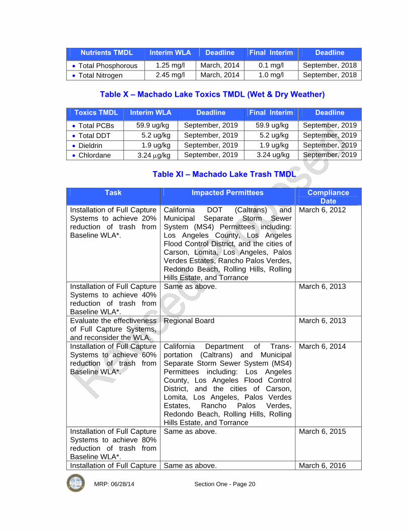
MRP: 06/28/14 Section One - Page 20
Nutrients TMDL Interim WLA Deadline Final Interim Deadline
• Total Phosphorous 1.25 mg/l March, 2014 0.1 mg/l September, 2018 • Total Nitrogen 2.45 mg/l March, 2014 1.0 mg/l September, 2018
Table X – Machado Lake Toxics TMDL (Wet & Dry Weather)
Toxics TMDL Interim WLA Deadline Final Interim Deadline
• Total PCBs 59.9 ug/kg September, 2019 59.9 ug/kg September, 2019 • Total DDT 5.2 ug/kg September, 2019 5.2 ug/kg September, 2019 • Dieldrin 1.9 ug/kg September, 2019 1.9 ug/kg September, 2019 • Chlordane 3.24 μg/kg September, 2019 3.24 ug/kg September, 2019
Table XI – Machado Lake Trash TMDL
Task Impacted Permittees Compliance
Date Installation of Full Capture Systems to achieve 20% reduction of trash from Baseline WLA*.
California DOT (Caltrans) and Municipal Separate Storm Sewer System (MS4) Permittees including: Los Angeles County, Los Angeles Flood Control District, and the cities of Carson, Lomita, Los Angeles, Palos Verdes Estates, Rancho Palos Verdes, Redondo Beach, Rolling Hills, Rolling Hills Estate, and Torrance
March 6, 2012
Installation of Full Capture Systems to achieve 40% reduction of trash from Baseline WLA*.
Same as above. March 6, 2013
Evaluate the effectiveness of Full Capture Systems, and reconsider the WLA.
Regional Board March 6, 2013
Installation of Full Capture Systems to achieve 60% reduction of trash from Baseline WLA*.
California Department of Trans-portation (Caltrans) and Municipal Separate Storm Sewer System (MS4) Permittees including: Los Angeles County, Los Angeles Flood Control District, and the cities of Carson, Lomita, Los Angeles, Palos Verdes Estates, Rancho Palos Verdes, Redondo Beach, Rolling Hills, Rolling Hills Estate, and Torrance
March 6, 2014
Installation of Full Capture Systems to achieve 80% reduction of trash from Baseline WLA*.
Same as above. March 6, 2015
Installation of Full Capture Same as above. March 6, 2016

MRP: 06/28/14 Section One - Page 21
Systems to achieve 100% reduction of trash from Baseline WLA*.
*Compliance with percent reductions from the Baseline WLA will be assumed wherever full capture systems are installed in corresponding percentages of the conveyance discharging to the water body. Installation will be prioritized based on the greatest point source loadings.
Table XII – Dry and Wet Weather TMDL WLAs for Compton Creek
Water Body Copper Lead Zinc Trash
Compton Creek 17 ug/l 62 ug/l 159 ug/l See Table X Below
Water Body Bacteria Daily Maximum Geometric Mean
Compton Creek o Hondo E-coli 235/100mL 126/100 mL
Water Body Ammonia-N NO3-N + NO2-N NO2-N NO3-N
Compton Creek 2.3 mg/l 8 mg/L 1 mg/L 8 mg/L
Dry Weather WLAs Water Body Copper Lead Zinc Trash
Compton Creek 19 ug/l
8.9 ug/l - Same As Wet
Weather
Water Body Bacteria (Interim) Bacteria (Final) - -
Compton Creek 7 MPN/day 126 MPN/100 ml - -
Table XIII – Compton Creek Trash TMDL
Year Implementation
Year Waste Load Allocation Compliance Point
9-08 Year 1 60% of Baseline Waste Load Allocations for the Municipal Permittees and Caltrans
60% of the baseline load
9-09 Year 2 50% of Baseline Waste Load Allocations for the Municipal Permittees and Caltrans
55% of the baseline load calculated as a 2-year annual average
9-10 Year 3 40% of Baseline Waste Load Allocations for the Municipal Permittees; and Caltrans
50% of the baseline load calculated as a rolling 3-year annual average

MRP: 06/28/14 Section One - Page 22
9-11 Year 4 30% of Baseline Waste Load Allocations for the Municipal Permittees; and Caltrans
40% of the baseline load calculated as a rolling 3-year annual average
9-12 Year 5 20% of Baseline Waste Load Allocations for the Municipal Permittees; and Caltrans
30% of the baseline load calculated as a rolling 3-year annual average
9-13 Year 6 10% of Baseline Waste Load Allocations for the Municipal Permittees; and Caltrans
20% of the baseline load calculated as a rolling 3-year annual average
9-14 Year 7 0% of Baseline Waste Load Allocations for the Municipal Permittees; and Caltrans
10% of the baseline load calculated as a rolling 3-year annual average
9-15 Year 8 0% of Baseline Waste Load Allocations for the Municipal Permittees; and Caltrans
3.3% of the baseline load calculated as a rolling 3-year annual average
9-16 Year 9 0% of Baseline Waste Load Allocations for the Municipal Permittees; and Caltrans
0% of the baseline load calculated as a rolling 3-year annual average
1.11 MAL Monitoring
Stormwater sampling against MAL analytes shall be performed at the
same time stormwater monitoring is performed for other purposes and with the
same frequency – three times during the wet season. The table below identifies
the MAL analytes and their numeric limitations.
Table XIV - Municipal Action Levels
Metals Unit Total Cadmium ug/l 2.52 Chromium ug/l 20.2 Copper ug/l 71.12 Lead ug/l 102 Zinc ug/l 641.3 Nickel ug/l 27.43

MRP: 06/28/14 Section One - Page 23
Conventional Pollutants Unit MAL
Total Phosphorus mg/l 0.80 Nitrate & Nitrite mg/l 1.85 Kjedahl Nitrogen (TKN) mg/l 4.59 COD mg/l 247.5 TSS mg/l 264.1 pH - 6 -9
1.12 Action Level Monitoring
The tables below lists non-stormwater action level analytes for
Dominguez Channel, Compton Creek, and Machado Lake. As mentioned,
the City does not intend to conduct action level or any other non-stormwater
monitoring at the outfall. Such monitoring is not authorized under the Clean
Water Act and is contrary to State Board water quality orders. Because non-
stormwater discharges are not subject to an iterative process an exceedance
would place a Permittee in violation. Nevertheless, the City shall conduct
non-stormwater monitoring to detect and eliminated illicit discharges and
connections (see below Section 1.14).
Table XV – Action Levels (Non-Stormwater) for Dominguez Channel
Analyte Units Average Monthly Daily Maximum
pH Standard units 6.5-8.51
Total Coliform bacteria #/100 ml 10002,3 10,0003,4 Fecal Coliform Bacteria #/100 ml 2002 4004 Enterococcus Bacteria #/100 ml 352 1044
Cyanide, Total Recoverable ug/L 0.5 1
Copper, Total Recoverable ug/L 2.9 5.8 Lead, Total Recoverable ug/L 7 14 Mercury, Total Recoverable ug/L 0.051 0.1 Selenium, Total Recoverable ug/L 58 117
1Within the range of 6.5 to 8.5 at all times. 2 Total coliform density shall not exceed a geometric mean of 1,000/100 ml. Fecal coliform density shall not exceed a geometric mean of 200/100 ml. Enterococcus density shall not exceed a geometric mean of 35/100 ml. 3 In areas where shellfish may be harvested for human consumption, as determined by the Regional Water Board, the median total coliform density shall not exceed 70/100 ml and not more than 10 percent of the samples shall exceed 230/100 ml. 4 Total coliform density in a single sample shall not exceed 10,000/100 ml. Fecal coliform density in a single sample shall not exceed 400/100 ml. Enterococcus density shall not exceed a geometric mean of 104/100 ml.

MRP: 06/28/14 Section One - Page 24
Table XVI – Action Levels (Non-Stormwater) for Los Angeles River
Analyte Units Average Monthly Daily Maximum
pH Standard units 6.5-8.51
Total Coliform bacteria #/100 ml 10002,3 10,0003,4 Fecal Coliform Bacteria #/100 ml 2002 4004 Enterococcus Bacteria #/100 ml 352 1044
Chloride mg/L 150 --
Nitrite Nitrogen. Total (as N) mg/L 1.0 6 --
Sulfate mg/L 350 --
Total Dissolved Solids mg/L 1500 --
Turbidity NTU 5 6 --
Aluminum, Total Recoverable ug/L 1.0 6 --
Cyanide, Total Recoverable ug/L 0.5 1
Copper, Total Recoverable ug/L 2.9 5.8 Mercury, Total Recoverable ug/L 0.051 0.1 Selenium, Total Recoverable ug/L 58 117
1.13 Additional Monitoring Required for I-WMP Compliance
MRP section VI.C.2.a.i and ii requires additional outfall monitoring
tasks for Permittees that opt for the WMP. They include pollutants that are
currently not TMDLs but are nevertheless 303(d) listed (e.g., cyanide).
Regional Board staff has suggested that other water quality standards be
included that can found in the previous MS4 in attachment U of the
Monitoring Program.
The purpose of this monitoring task is to identify non-TMDL pollutants
are causing impairments to beneficial uses of receiving waters and to
evaluate the effectiveness of BMPs implemented through the SWMP/WMP.
They are also included to determine if non-TMDL pollutants are causing or
contributing to exceedances of receiving water limitations. The City takes the
position that the detection of an exceedance does not constitute a violation.
MRP: 06/28/14 Section One - Page 25
Any persistent exceedance of a TMDL or water quality standard monitored
over the term of the Permit would not constitute a violation provided that (1)
the SWMP/WMP is being implemented in a timely and complete manner; and
(2) complies with the iterative process described in MS4 Permit section
V.A.1-4.
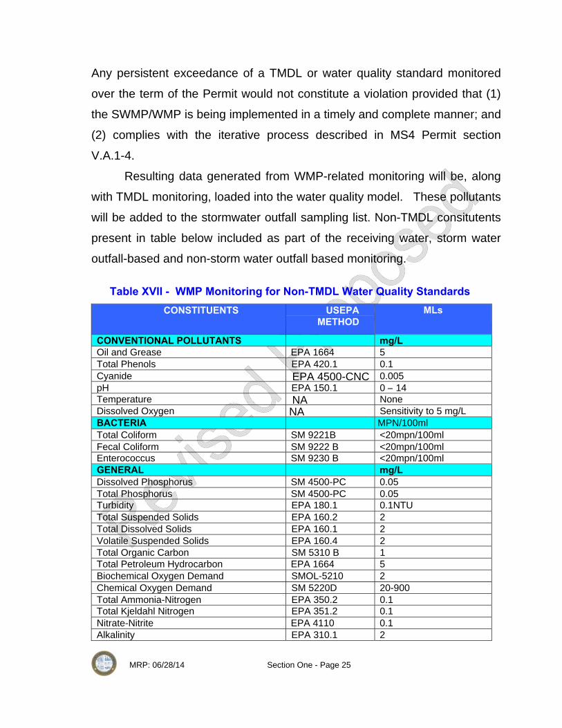
Resulting data generated from WMP-related monitoring will be, along
with TMDL monitoring, loaded into the water quality model. These pollutants
will be added to the stormwater outfall sampling list. Non-TMDL consitutents
present in table below included as part of the receiving water, storm water
outfall-based and non-storm water outfall based monitoring.
Table XVII - WMP Monitoring for Non-TMDL Water Quality Standards CONSTITUENTS USEPA
METHOD MLs
CONVENTIONAL POLLUTANTS mg/L Oil and Grease EPA 1664 5 Total Phenols EPA 420.1 0.1 Cyanide EPA 4500-CNC 0.005 pH EPA 150.1 0 – 14 Temperature NA None Dissolved Oxygen NA Sensitivity to 5 mg/L BACTERIA MPN/100ml Total Coliform SM 9221B <20mpn/100ml Fecal Coliform SM 9222 B <20mpn/100ml Enterococcus SM 9230 B <20mpn/100ml GENERAL mg/L Dissolved Phosphorus SM 4500-PC 0.05 Total Phosphorus SM 4500-PC 0.05 Turbidity EPA 180.1 0.1NTU Total Suspended Solids EPA 160.2 2 Total Dissolved Solids EPA 160.1 2 Volatile Suspended Solids EPA 160.4 2Total Organic Carbon SM 5310 B 1 Total Petroleum Hydrocarbon EPA 1664 5 Biochemical Oxygen Demand SMOL-5210 2 Chemical Oxygen Demand SM 5220D 20-900 Total Ammonia-Nitrogen EPA 350.2 0.1Total Kjeldahl Nitrogen EPA 351.2 0.1 Nitrate-Nitrite EPA 4110 0.1 Alkalinity EPA 310.1 2

MRP: 06/28/14 Section One - Page 26
Specific Conductance EPA 120.1 1umho/cm Total Hardness EPA 130.2 2MBAS SM 5540 C <0.5 Chloride EPA 300 2 Fluoride EPA 300 0.1 Methyl tertiary butyl ether (MTBE) EPA 4110 1 Perchlorate EPA 314.0 4 ug/l METALS(Dissolved & Total) µg/L Aluminum EPA 200.8 100 Antimony EPA 200.8 0.5 Arsenic EPA 200.8 1 Beryllium EPA 200.8 0.5 Cadmium EPA 200.8 0.25 Chromium (total) EPA 200.8 0.5 Chromium (Hexavalent) EPA 200.8 5 Copper EPA 200.8 0.5 Iron EPA 200.8 100 Lead EPA 200.8 0.5 Mercury EPA 1631 0.5 Nickel EPA 200.8 1 Selenium EPA 200.8 1 Silver EPA 200.8 0.25 Thallium EPA 200.8 1 zinc EPA 200.8 1 SEMIVOLATILE ORGANIC COMPOUNDS ACIDS µg/L 2-Chlorophenol EPA 625 2 4-Chloro-3-methylphenol EPA 625 1 2,4-Dichlorophenol EPA 625 1 2,4-Dimethylphenol EPA 625 2 2,4-Dinitrophenol EPA 625 5 2-Nitrophenol EPA 625 10 4-Nitrophenol EPA 625 5 Pentachlorophenol EPA 625 2 Phenol EPA 625 1 2,4,6-Trichlorophenol EPA 625 10 BASE/NEUTRAL µg/L Acenaphthene EPA 625 1 Acenaphthylene EPA 625 2 Anthracene EPA 625 2 Benzedine EPA 625 5 1,2 Benzanthracene EPA 625 5 Benzo(a)pyrene EPA 625 2 Benzo(g,h,i)perylene EPA 625 5 3,4 Benzoflouranthene EPA 625 10 Bis(2-Chloroethoxy) methane EPA 625 2 Bis(2-Chloroisoproply) ether EPA 625 5 Bis(2-Chloroethyl) ether EPA 625 2

MRP: 06/28/14 Section One - Page 27
Bis(2-Ethylhexl) phthalate EPA 625 1 4-Bromophenyl Phenyl ether EPA 625 5 Butyl benzyl phthalate EPA 625 5 2-Chloroethyl vinyl ether EPA 625 10 2-Chloronaphthalene EPA 625 1 4-Chlorophenyl phenyl ether EPA 625 10 Chrysene EPA 625 5 Dibenzo(a,h)anthracene EPA 625 5 1,3-Dichlorobenzene EPA 625 0.1 1,4-Dichlorobenzene EPA 625 1 1,2-Dichlorobenzene EPA 625 1 3,3-Dichlorobenzidine EPA 625 1 Diethyl phthalate EPA 625 5 Dimethyl phthalate EPA 625 2 di-n-Butyl phthalate EPA 625 2 2,4-Dinitrotoluene EPA 625 10 2,6-Dinitrotoluene EPA 625 5 4,6 Dinitro-2-methylphenol EPA 625 5 1,2-Diphenylhydrazine EPA 625 5 di-n-Octyl phthalate EPA 625 1 Fluoranthene EPA 625 10 Fluorene EPA 625 0.05 Hexachlorobenzene EPA 625 0.1 Hexachlorobutadiene EPA 625 1 Hexachloro-cyclopentadiene EPA 625 5 Hexachloroethane EPA 625 1 Indeno(1,2,3-cd)pyrene EPA 625 0.05 Isophorone EPA 625 1 Naphthalene EPA 625 1 Nitrobenzene EPA 625 0.2 N-Nitroso-dimethyl amine EPA 625 5 N-Nitroso-diphenyl amine EPA 625 1 N-Nitroso-di-n-propyl amine EPA 625 5 Phenanthrene EPA 625 0.05 Pyrene EPA 625 0.05 1,2,4-Trichlorobenzene EPA 625 1 CHLORINATED PESTICIDES μg/L Aldrin EPA 608 0.005
alpha-BHC EPA 608 0.01 beta-BHC EPA 608 0.005 delta-BHC EPA 608 0.005 gamma-BHC (lindane) EPA 608 0.02 alpha-chlordane EPA 8270 0.1 gamma-chlordane EPA 8270 0.1 4,4’-DDD EPA 8270 0.05 4,4’-DDE EPA 8270 0.05 4,4’-DDT EPA 8270 0.01 Dieldrin EPA 608 0.01

MRP: 06/28/14 Section One - Page 28
alpha-Endosulfan EPA 608 0.02 beta-Endosulfan EPA 608 0.01 Endosulfan sulfate EPA 608 0.05 Endrin EPA 608 0.01 Endrin aldehyde EPA 608 0.01 Heptachlor EPA 608 0.01 Heptachlor epoxide EPA 608 0.01 Toxaphene EPA 608 0.5 POLYCHLORINATED BIPHENYLS μg/L Aroclor-1016 EPA 608 0.5 Aroclor-1221 EPA 608 0.5 Aroclor-1232 EPA 608 0.5 Aroclor-1242 EPA 608 0.5 Aroclor-1248 EPA 608 0.5 Aroclor-1254 EPA 608 0.5 Aroclor-1260 EPA 608 0.5 Congeners3 EPA 8270C NA ORGANOPHOSPHATE PESTICIDES µg/L Atrazine EPA 8141A/B 2 Chlorpyrifos EPA 8141A/B 0.05 Cyanazine EPA 8141A/B 2 Diazinon EPA 8141A/B 0.01 Malathion EPA 8141A/B 1 Prometryn EPA 8141A/B 2 Simazine EPA 8141A/B 2 HERBICIDES μg/L 2,4-D EPA 8151A 10 Glyphosate EPA 8151A 5 2,4,5-TP-SILVEX EPA 8151A 0.5 SOLIDS mg/L Total Suspended Solids (TSS) SM 2540D 2 Suspended Sediment Concentration (SSC) ASTM D3977-97C NA Volatile Suspended Solids EPA 1684 2 1.14 Non-stormwater Monitoring for IC/ID
As mentioned above, the City proposes to perform non-stormwater
monitoring to detect and eliminate illicit connections and discharges in
accordance with 40 CFR 122.26(d)(1)(D). Monitoring will consist of dry
weather visual observations at outfalls or field screening points, which shall be
conducted monthly during the dry season (May 1 to September 30) -- see
Appendix A-1 for field screening locations. If flow is detected, grab samples

MRP: 06/28/14 Section One - Page 29
are to be taken within a 24 hour period and measured against fecal coliform,
fecal streptococcus, surfactants (MBAS), residual chlorine, fluorides, and
potassium. Other constituents may be added later based on USEPA’s ICID-DE
guidance manual.
1.15 Reporting Requirements
The City shall comply with all reporting requirements specified in the
MRP. The City cannot begin to report monitoring results until: (1) the I-
WMP and MRP have been approved by the Regional Board, (expected to
happen 4 months after the June 28th WMP submittal date); and (2) one round
of monitoring has been conducted during October 2014-April 2015 wet
season. Results will be reported to the Regional Board on or before
December of 2015. By this time, it is expected that the County of Los
Angeles will have developed a standardized annual report form that will
include reporting criteria for the MS4 Permit, TMDLs, MALs and certain water
quality standards.
1.16 Monitoring Protocols
The MRP requires a variety of monitoring requirements that are
governed by monitoring protocols established by USEPA, which are
summarized below.
I. Receiving Monitoring Protocol Minimum required receiving water monitoring frequencies are
defined in section VI.C of Attachment E in the MS4 Permit. Wet weather is
defined as when the flow with the receiving water is at least 20% greater
that the base flow. In an effort to simplify the wet weather definition the City
will utilize the definition in Attachment A of the MS4 Permit, which defines
the wet season as the time period between October 1st and April 15th

MRP: 06/28/14 Section One - Page 30
unless a storm event that is qualified to be targeted as the first event of the
year is forecasted within a reasonable amount of time prior to October 1st.
Wet weather monitoring will occur at least three times per year for all
applicable parameters with the exception for aquatic toxicity. Aquatic
toxicity monitoring will be conducted at a minimum of twice per year. The
first wet weather event with a predicted rainfall of .25 inches with a 70%
probability 24 hours prior to rain fall will be targeted for monitoring. At a
minimum two additional rainfall events with a minimum separation of three
dry days (less than .1 inch of rain per day) between monitoring will be
monitored to meet the minimum requirement of three storm events per
year. Receiving water monitoring shall be coordinated to start as soon as
possible following storm water outfall monitoring to better reflect the
potential impact from MS4 discharges.
Dry weather monitoring requirements are defined in section VI.D of
Attachment E in the MS4 Permit. Monitoring shall take place a minimum of
two times per year for all parameters, or more if required by a TMDL
monitoring plan. At least one of the monitoring events shall take place
during the historically driest month of the year. Typically the driest month of
the year is in August, which will be utilized for the time period of which at
least one of the monitoring events occurs.
II. Non-storm water outfall based sampling Protocol
Dry weather samples will be collected on days there has be no
measurable precipitation within the last three days. Grab samples will be
taken for constituents that are required to be collected by grab sampling. If
the City cannot install an automated sampler, grab samples will be
collected. Flow will be estimated for storm water outfall monitoring sites
based on drainage area, impervious cover, and precipitation data.

MRP: 06/28/14 Section One - Page 31
III. Outfall Based sampling protocol
For each field screening point, sample shall be collected of storm
water discharge from three storm events occurring at least one month apart
in accordance with the requirements indicated below:
• For storm water discharges, all samples shall be collected from the
discharge resulting flow with the receiving water is at least 20%
greater that the base flow. For Dominguez channel wet weather
define as any day when the maximum daily flow measured at a
location within the Dominguez Channel is equal to or greater than
62.7 cfs, a flow-weighted composite shall be taken in each hour of
discharge for the first 24 hours of the discharge or for the entire
discharge if the storm event is less than 24 hours. The flow-weighted
composite sample for a storm water discharge may be taken with a
continuous sampler or as a combination of a minimum of three
sample aliquots taken in each hour of discharge for the first 24 hours
of the discharge or for the entire discharge if the storm event is less
than 24 hours., with each aliquot being separated by a minimum
period of twenty minutes. In addition City will targeted first storm
event of the storm year with a predicted rainfall of at least 0.25 inch at
a 70% probability of rainfall at least 24 hours prior to the event start
time. Another two wet weather monitoring will happen when predicted
rain is equal or more than 0.1 inches and minimum 3 consecutive
days of dry weather.
• Sampling of storm water from field screening points will take place
during 24 hours of an event or before the event ends if less than 24
hours. A minimum of three grab samples separated by 15 minutes of
each hour for a 24 hour event or for the duration of the storm, if less

MRP: 06/28/14 Section One - Page 32
than 24 hours, will be taken to create a flow weighted composite
sample of the discharge from an outfall. Grab samples may be utilize
for specific pollutants such as bacteria, oil & grease, volatile organics
and cyanides. For all storm water permit applicants taking flow-
weighted composites, quantitative data must be reported for all
pollutants specified in §122.26 except pH, temperature, cyanide, total
phenols, residual chlorine, oil and grease, fecal coliform, and fecal
streptococcus.
• A storm event that is greater than 0.1 inch and at least 72 hours
from the previously measurable (greater than 0.1 inch rainfall) storm
event. For all applicants, a flow-weighted composite shall be taken
for either the entire discharge or for the first three hours of the
discharge. The flow-weighted composite sample for a storm water
discharge may be taken with a continuous sampler or as a
combination of a minimum of three sample aliquots taken in each
hour of discharge for the entire discharge or for the first three hours
of the discharge, with each aliquot being separated by a minimum
period of fifteen minutes. For a flow-weighted composite sample,
only one analysis of the composite of aliquots is required. For all
storm water permit applicants taking flow-weighted composites,
quantitative data must be reported for all pollutants specified in
§122.26 except pH, temperature, cyanide, total phenols, residual
chlorine, oil and grease, fecal coliform, and fecal streptococcus.
IV. Toxicity Monitoring/Testing Protocol
The approach to conducting aquatic toxicity monitoring is
presented in Figure C-1, which describes a general evaluation process
for each sample collected as part of routine sampling conducted twice

MRP: 06/28/14 Section One - Page 33
per year in wet weather and once per year in dry weather. Monitoring
begins in the receiving water and the information gained is used to
identify constituents for monitoring at outfalls to support the identification
of pollutants.

MRP: 06/28/14 Section One - Page 34
1.17 Implementation Schedule (Milestones) The table below provides a schedule for implementing MRP/CIMP
tasks. Table XVIII – Implementation Schedule
Task Deadline Date • Submit WMP, MRP, and CIMP to Regional Board No later than June 28,
2014 • Using GIS mapping, provide land use overlay of City’s
storm drain system No later than June 28, 2014
• Using GIS mapping, show City’s storm drain system including catch basins and connections to receiving waters
No later than June 28, 2014
• Using GIS mapping, identify watershed and sub-watershed based on Los Angeles County’s HUC 12 equivalent boundaries
No later than June 28, 2014
• Using GIS mapping, identify: stormwater outfalls and field screening points; mass emission and other in-stream monitoring points/stations; and ambient monitoring locations established by the Regional Board’s Surface Water Ambient Monitoring Program (SWAMP); and locations established by the Council for Watershed Health.
No later than June 28, 2014
• Conduct outfall monitoring for stormwater discharges for TMDLs, other water quality standards, MALs, and toxicity three times beginning during 2015-2016 wet season and annually thereafter.
Beginning no later than October of 2015
• During the dry season, conduct monthly non-stormwater visual observations and grab sampling if flow is detected.
No later than May 1, 2015
• If no data exists the City shall contract for the CWH to conduct ambient monitoring once during the term of the Permit for Dominguez Channel (costs to be shared with the cities of Carson and Gardena)
No later than June 28, 2015
• Review available ambient monitoring data and studies to assess the health of the Dominguez at both reaches (above and below Vermont Avenue)
No later than June 28, 2014
• Submit annual monitoring reports to the Regional Board of any available TMDL or other water quality standards data generated through outfall monitoring.
Beginning no later than December of 2014
• Submit new development/redevelopment track form. No later than one month following the Regional Board’s approval of the CIMP
END SECTION ONE MRP-IMP

MRP: 06/28/14 Section One - Page 35
Appendix A Maps

MRP: 06/28/14 Section One - Page 36
Appendix A-1 Outfall and Receiving Water
Location Map

MRP: 06/28/14 Section One - Page 37

MRP: 06/28/14 Section One - Page 38
Appendix A-2 Field Screening Point Location
with HUC 12 Boundaries

MRP: 06/28/14 Section One - Page 39

MRP: 06/28/14 Section One - Page 40
Appendix A-3 Watershed/Sub-watershed
& City Boundary Map

MRP: 06/28/14 Section One - Page 41

MRP: 06/28/14 Section One - Page 42

MRP: 06/28/14 Section One - Page 43
Appendix A-4
Storm Drain/Catch Basin Map

MRP: 06/28/14 Section One - Page 44

MRP: 06/28/14 Section One - Page 45
Appendix A-5
City Land Use Map

MRP: 06/28/14 Section One - Page 46
MRP: 06/28/14 Section One - Page 47
Appendix A-3 HUC - 12
& City Boundary Map

MRP: 06/28/14 Section One - Page 48

MRP: 06/28/14 Section One - Page 49
Appendix B 2010 303(d) List for
Dominguez Channel, Machado Lake, and Los Angeles River
(Compton Creek)

MRP: 06/28/14 Section One - Page 50
Appendix B
Table XIX – 303(d) List – Dominguez Channel
2010 303 (d) List Water Body Parameter
TMDL Status Date
Source
Pollutant Category
Ammonia
2019
Nonpoint/Point Source
TMDL Require List
BMB
2019
Nonpoint/Point Source
TMDL Require List
Benzo Pyrene (PAHs)
2019
Source Unknown
TMDL Require List
Benzo Anthracene (PAHs)
2019
Source Unknown
TMDL Require List
Chlordane (tissue)
2019
Source Unknown
TMDL Require List
Chrysene (C1-C4)
2019
Source Unknown
TMDL Require List
Coliform Bacteria
2007
Nonpoint/Point Source
TMDL Require List
DDT (tissue & Sediment)
2019
Nonpoint/Point Source
TMDL Require List
Dieldrin (tissue)
2019
Nonpoint/Point Source
TMDL Require List
Lead (tissue)
2019
Nonpoint/Point Source
TMDL Require List
PCBs
2019
Source Unknown
TMDL Require List
Phenanthrene
2019
Source Unknown
TMDL Require List
Pyrene
2019
Source Unknown
TMDL Require List
Zinc (sediment)
2019
Nonpoint/Point Source
TMDL Require List
Dominguez Channel (below
Vermont Avenue)
Sediment Toxicity
2021 Nonpoint Source TMDL Require List
Ammonia 2019 Point Source TMDL Require List
Copper 2019 Nonpoint/Point Source
TMDL Require List
Dominguez Channel (Above Vermont Avenue)
Indicator Bacteria 2007 Nonpoint/Point Source
TMDL Require List

MRP: 06/28/14 Section One - Page 51
Lead 2019 Nonpoint/Point Source
TMDL Require List
Toxicity 2021 Nonpoint/Point Source
TMDL Require List
Zinc 2019 Nonpoint/Point Source
TMDL Require List
Diazinon 2019 Source Unknown TMDL Require List
Table XX – 303(d) List – Machado Lake
2010 303 (d) List Water Body
Parameter
TMDL Status Date
Source
Pollutant Category
Machado Lake
Algae
2009
Urban Runoff
Being address by USEPA approval TMDL
Ammonia
2019
Urban Runoff
Being address by USEPA approval TMDL
Chem A(tissue)
2019
Non-Point Source
TMDL Require List
Chlordane (tissue)
2019
Non-Point Source
TMDL Require List
DDT (tissue)
2019
Non-Point Source
TMDL Require List
Dieldrin (tissue)
2019
Non-Point Source
TMDL Require List
Eutrophic
2009
Urban Runoff
Being address by USEPA approval TMDL
PCBs (tissue)
2019
Non-Point Source
TMDL Require List
Trash 2008 Urban Runoff
Being address by USEPA approval TMDL
Table XXI – 303(d) List – Los Angeles River Compton Creek
2010 303 (d) List
Water Body Parameter
TMDL
Status Date
Source
Pollutant Category
Coliform Bacteria
2009
Nonpoint/Point Source
TMDL Require List Los Angeles River -Compton Creek
Trash
2005
Nonpoint/Surface Runoff
Being address by USEPA approval TMDL

MRP: 06/28/14 Section One - Page 52
Copper, Dissolved
2005
Nonpoint/Point Source
Being address by USEPA approval TMDL
Lead, Dissolved
2005
Nonpoint/Point Source
Being address by USEPA approval TMDL
pH
2004
Nonpoint/Point Source
Being address by USEPA approval TMDL
Benthic Macroinvertabrate Bioassessments
2021 Source Unknown
TMDL Require List

MRP: 06/28/14 Section One - Page 53
Appendix C Total Maximum Daily Loads

MRP: 06/28/14 Section One - Page 54
Appendix C-1 Dominguez Channel TMDLs

MRP: 06/28/14 Section One - Page 55
Appendix C-2 Machado Lake TMDLs

MRP: 06/28/14 Section One - Page 56
Appendix C-3 Los Angeles River (Reach 1) and Compton Creek TMDLs