
Section 7 Guidelines for Riparian Management Zones
29
Board Manual – 2/2010 Riparian Management Zones (RMZ) M7-1 Section 7 Guidelines for Riparian Management Zones This manual contains guidance for planning forest practices management in riparian management zones adjacent to Type S and F Waters and near sensitive sites associated with Type Np Waters. The guidance supplements WAC 222-30-021 and WAC 222-30-022, the rules that regulate forest practices in forest lands adjacent to water for Western Washington and Eastern Washington riparian management zones. The manual uses the term “RMZ rules” to describe those rules. There are terms in this manual that are familiar to people who routinely work in Washington State’s forest practices, but are unfamiliar to others. Examples are the water types, (“Type S”, “Type F”, “Type Np”), “bankfull width”, “channel migration zone”, “core zone”, and “inner zone.” Please refer to definitions in chapter 222-16 WAC for these and other forest practices terms used in this manual. PART 1. IMPLEMENTING THE WESTERN WASHINGTON RMZ RULES ............................. 1 1.1 INTRODUCTION ......................................................................................................................... 1 1.2 WESTERN WASHINGTON RMZS FOR TYPE S AND F WATERS: INSTRUCTIONS FOR COMPLETING A STAND ANALYSIS AND HARVEST OPTION EVALUATION. ............................................................... 2 PART 2. IMPLEMENTING THE EASTERN WASHINGTON RMZ RULES .............................. 4 2.1 INTRODUCTION ......................................................................................................................... 4 2.2 EASTERN WASHINGTON RMZS FOR TYPE S AND F WATERS: INSTRUCTIONS FOR COMPLETING A STAND ANALYSIS AND DETERMINING LEAVE TREES. .................................................................... 4 PART 3. IDENTIFYING SENSITIVE SITES ALONG TYPE NP WATERS IN WESTERN AND EASTERN WASHINGTON ............................................................................................................ 5 3.1 HEADWALL SEEPS .................................................................................................................... 5 3.2 SIDE-SLOPE SEEPS .................................................................................................................... 6 3.3 TYPE NP INTERSECTIONS .......................................................................................................... 6 3.4 HEADWATER SPRINGS .............................................................................................................. 7 3.5 ALLUVIAL FANS ....................................................................................................................... 7 APPENDIX A TREE DATA COLLECTION FORM ..................................................................... 9 APPENDIX B EXAMPLE OF DESIRED FUTURE CONDITION WORKSHEET DATA ENTRY PAGE AND SUMMARY PAGES ................................................................................... 10 APPENDIX C EASTERN WASHINGTON BASAL AREA AND LEAVE TREE TABLES ..... 16 APPENDIX D EASTERN WASHINGTON RMZS, TYPE S AND F WATERS ........................ 21 PART 1. IMPLEMENTING THE WESTERN WASHINGTON RMZ RULES 1.1 Introduction The Western Washington RMZ rules are in WAC 222-30-021. Harvest is permitted within the inner zone of an RMZ adjacent to a Type S or F Water in Western Washington only if the timber stand exceeds the “stand requirement” described in WAC 222-30-021(1): “Stand requirement” means a number of trees per acre, the basal area and the proportion of conifer in the combined inner zone and adjacent core zone so that the growth of trees would meet desired future conditions.
Transcript of Section 7 Guidelines for Riparian Management Zones

Board Manual – 2/2010 Riparian Management Zones (RMZ)
M7-1
Section 7 Guidelines for Riparian Management Zones
This manual contains guidance for planning forest practices management in riparian management zones adjacent to Type S and F Waters and near sensitive sites associated with Type Np Waters. The guidance supplements WAC 222-30-021 and WAC 222-30-022, the rules that regulate forest practices in forest lands adjacent to water for Western Washington and Eastern Washington riparian management zones. The manual uses the term “RMZ rules” to describe those rules. There are terms in this manual that are familiar to people who routinely work in Washington State’s forest practices, but are unfamiliar to others. Examples are the water types, (“Type S”, “Type F”, “Type Np”), “bankfull width”, “channel migration zone”, “core zone”, and “inner zone.” Please refer to definitions in chapter 222-16 WAC for these and other forest practices terms used in this manual. PART 1. IMPLEMENTING THE WESTERN WASHINGTON RMZ RULES ............................. 1
1.1 INTRODUCTION ......................................................................................................................... 1 1.2 WESTERN WASHINGTON RMZS FOR TYPE S AND F WATERS: INSTRUCTIONS FOR COMPLETING A STAND ANALYSIS AND HARVEST OPTION EVALUATION. ............................................................... 2
PART 2. IMPLEMENTING THE EASTERN WASHINGTON RMZ RULES .............................. 4 2.1 INTRODUCTION ......................................................................................................................... 4 2.2 EASTERN WASHINGTON RMZS FOR TYPE S AND F WATERS: INSTRUCTIONS FOR COMPLETING A STAND ANALYSIS AND DETERMINING LEAVE TREES. .................................................................... 4
PART 3. IDENTIFYING SENSITIVE SITES ALONG TYPE NP WATERS IN WESTERN AND EASTERN WASHINGTON ............................................................................................................ 5
3.1 HEADWALL SEEPS .................................................................................................................... 5 3.2 SIDE-SLOPE SEEPS .................................................................................................................... 6 3.3 TYPE NP INTERSECTIONS .......................................................................................................... 6 3.4 HEADWATER SPRINGS .............................................................................................................. 7 3.5 ALLUVIAL FANS ....................................................................................................................... 7
APPENDIX A TREE DATA COLLECTION FORM ..................................................................... 9 APPENDIX B EXAMPLE OF DESIRED FUTURE CONDITION WORKSHEET DATA ENTRY PAGE AND SUMMARY PAGES ................................................................................... 10 APPENDIX C EASTERN WASHINGTON BASAL AREA AND LEAVE TREE TABLES ..... 16 APPENDIX D EASTERN WASHINGTON RMZS, TYPE S AND F WATERS ........................ 21 PART 1. IMPLEMENTING THE WESTERN WASHINGTON RMZ RULES 1.1 Introduction The Western Washington RMZ rules are in WAC 222-30-021. Harvest is permitted within the inner zone of an RMZ adjacent to a Type S or F Water in Western Washington only if the timber stand exceeds the “stand requirement” described in WAC 222-30-021(1):
“Stand requirement” means a number of trees per acre, the basal area and the proportion of conifer in the combined inner zone and adjacent core zone so that the growth of trees would meet desired future conditions.

Riparian Management Zones (RMZ) Board Manual – 2/2010
M7-2
The basal area target for a 140 year old stand is 325 square feet per acre. To find out if your timber stand exceeds the stand requirement (and if you will be permitted to harvest trees within the inner zone of the RMZ) you must collect information on all of the trees in the core and inner zones of your harvest unit and enter it into a web-based Desired Future Condition Worksheet. Please note: • Shade must be provided as described in WAC 222-30-040 regardless of harvest opportunities
in the RMZ inner and outer zones. Shade requirements apply within the first 75 feet from the outer edge of the bankfull width or channel migration zone, in addition to the RMZ rules. For guidance, see Board Manual Section 1 for determining adequate shade.
• Forest lands in the high elevation timber habitat type in Eastern Washington are subject to the same stand requirements as for Western Washington riparian management zones. You should follow this part (Part 2) of the manual if your harvest unit is in this timber habitat type.
1.2 Western Washington RMZs for Type S and F Waters: Instructions for completing a stand analysis and harvest option evaluation. Harvest is permitted in the inner zone of the RMZ only if a stand exceeds the “stand requirement” described in WAC 222-30-021(1).1 Riparian prescriptions are dependent on site productivity, stand composition (percent conifer, trees per acre, and basal area per acre) and stand age. To determine your inner zone harvest opportunity, you will use the Department of Natural Resources’ web-based computer program to enter your tree data. The program will calculate and report if your stand exceeds the stand requirement, whether you will be permitted to harvest in the inner zone, and what your harvest options are. Appendix B contains images you will see when working in the web-based Desired Future Condition Worksheet. After you enter site information and tree data, the program will provide several DFC summary pages showing your harvest options. What you will need to do before data entry. You will need to measure the diameters of the trees and count all trees in the core zone and inner zone in the 6-inch diameter class and larger. You may use the Tree Data Collection Form in Appendix A to gather your tree information. To gather your tree information:
• Count trees by diameter class in the 50-foot core zone; and
1 If your stand does not exceed the stand requirement, harvest will still be allowed in the outer zone as long as the required leave trees specified in WAC 222-30-021(1)(c) are left and the appropriate zone widths are used. The zone widths are specified in the table labeled “No inner zone management RMZ widths for Western Washington” in WAC 222-30-021(1)(b).

Board Manual – 2/2010 Riparian Management Zones (RMZ)
M7-3
• Count trees by diameter class in an inner zone of the following width (in feet) according to your harvest unit’s site class and stream size:
In addition to gathering your tree information, you will need the following information at hand for data entry into the Desired Future Condition Worksheet. (Additional instructions for data entry are available on the worksheet by clicking on “Getting Started” in the upper left of the area of the screen.)
• The legal description. • Site class. To determine site class, download a Forest Practices Application/ Notification
activity map for your area and activate the site class layer. Go to https://www.dnr.wa.gov/programs-and-services/forest-practices/forest-practices-application-review-system-fpars and under the heading, “Forest Practices Application/Notification”, click on “Print an activity map.” After navigating to the location of your activity, in the left corner under the “Select a map” button, choose Site Class Map. In the upper right corner, click on the “Legend” button to find the site class of your activity.
• Major species. This refers to conifer species and is determined by stem count. If there are more Douglas fir stems than other conifer tree species, choose Douglas fir. If there are fewer Douglas fir stems than other conifer species, choose western hemlock.
• Stream size. Choose “small” for a stream with an average bankfull width of ≤10 feet, and “large” for a stream with an average bankfull width >10 feet. If you need guidance on determining bankfull width, please refer to Board Manual Section 2.
• RMZ length. • DBH class. Tree data is to be entered for each 2-inch diameter class, no smaller than the 6-
inch diameter class. • DBH classes total. This is the total number of diameter classes entered for each zone. For
example, if you enter tree data for DBH classes 6, 8, 10, 18, and 20, the DBH classes total is 5.
• Stand age. Stand age is the average age of the dominant conifer trees in a stand. Stand age can be estimated by increment boring. Bore the dominant conifer trees within the riparian zone and average the growth ring counts. Increment boring shall be made at 4.5 feet above the ground on the uphill side of the tree. Add five years to the growth ring count to account for growth up to boring height. Stand age can also be determined from a landowner inventory or stand history if available.
You must complete a separate Desired Future Condition Worksheet for each stream or stream segment within your project, and attach DFC summary pages for each stream or stream segment to your forest practices application. How to access the Department of Natural Resources’ web-based Desired Future Condition Worksheet.
site class small streams (≤ 10 feet) large streams (>10 feet)
I 84 100 II 64 78 III 44 55 IV 23 33 V 10 18

Riparian Management Zones (RMZ) Board Manual – 2/2010
M7-4
Now that you have gathered all of your stand information, you can easily enter it into the Desired Future Condition Worksheet. Access the worksheet at https://www.dnr.wa.gov/programs-and-services/forest-practices/review-applications-fpars/forest-practices-forms-and, or go to http://www.dnr.wa.gov, and navigate as follows: Under Programs and Services, click on Forest Practices; Under Topics, click on Forest Practices Forms and Instructions; Scroll down to and click on DFC Worksheet Version 3.0. You may click on “Getting Started” for instructions on the appropriate data to be entered into each field and for information on evaluating your harvest options. PART 2. IMPLEMENTING THE EASTERN WASHINGTON RMZ RULES 2.1 Introduction The Eastern Washington RMZ rules are in WAC 222-30-022. The zone widths are shown in the beginning of the rule. The inner zone width for forest land adjacent to streams ≤ 15 feet wide is 45 feet, and for forest land adjacent to streams > 15 feet wide is 70 feet, in addition to the 30-foot core zone. Timber harvest rules for Eastern Washington RMZs vary by timber habitat type (Ponderosa pine, mixed conifer, and high elevation), and by site index in the case of the mixed conifer habitat type. For the high elevation timber habitat type (≥ 5,000 feet elevation) the stand must exceed 325 square feet per acre for all site classes in the combined core and inner zone. This stand requirement is the same as for Western Washington Type S and F Waters, and the guidelines in Part 1 should be followed for this timber habitat type. Please note: Shade must be provided as described in WAC 222-30-040 regardless of harvest opportunities in the RMZ inner and outer zones. Shade requirements apply within the first 75 feet from the outer edge of the bankfull width or channel migration zone, in addition to the RMZ rules. For guidance, see Board Manual Section 1 for determining adequate shade. 2.2 Eastern Washington RMZs for Type S and F Waters: Instructions for completing a stand analysis and determining leave trees. This manual offers two tools to help you to determine whether harvest is likely to be permitted in the inner zone of your Ponderosa pine or mixed conifer habitat type - and if so, the trees that must be left after harvest.
• Appendix C contains a set of tables specific to each timber habitat and stream type that give stand requirement and leave tree estimates for a variety of stream RMZ lengths. You may compare these estimates with your stand characteristics to get a general idea whether harvest is likely to be allowed in your stand. This is optional.
• Appendix D contains step-by-step guidelines to conduct a stand analysis and determine your harvest opportunity and leave tree requirements.

Board Manual – 2/2010 Riparian Management Zones (RMZ)
M7-5
PART 3. IDENTIFYING SENSITIVE SITES ALONG TYPE NP WATERS IN WESTERN AND EASTERN WASHINGTON The rules for protecting sensitive sites for Western Washington and for Eastern Washington are in WAC 222-222-30-021(2)(b) and WAC 222-30-022(2)(b)(ii), respectively. Sensitive sites are areas near or adjacent to Type Np Waters that are protected from forestry-related activities because they provide important habitat and function for aquatic resources. They are:
• headwall seeps • side-slope seeps • headwater springs • Type Np intersections • alluvial fans
Each of these features is defined under “sensitive sites” in WAC 222-16-010; however, their characteristics are described in more detail below to help you identify and protect them. 3.1 Headwall Seeps Timber harvest is not allowed within 50 feet of the outer perimeter of soil perennially saturated from a headwall seep in Western Washington and under the clearcut harvest strategy in Eastern Washington. Headwall seeps are wetted areas located at the base of cliffs or other steep areas, and where present are found at the head of Type Np Waters. Headwall seeps connect to the stream channel via overland flow, and are often characterized by loose substrate or fractured bedrock. Water occurs at or near the surface of headwall seeps year-round. Headwall seeps that are associated with the spray from falling water may be especially important to amphibians. The vegetation communities associated with headwall seeps are similar to those of wetlands, and may contain some or all of the following taxa: sedges, rushes, horsetails, willows, devils club, salmonberry, skunk cabbage, piggyback plant, lady fern, leafy liverwort, black cottonwood, Oregon ash, or red alder. Headwall seeps may have tree canopy gaps that may be visible from aerial photos, although the presence or absence of seeps must be confirmed using ground-based observation.
Riparian Management Zones (RMZ) Board Manual – 2/2010
M7-6
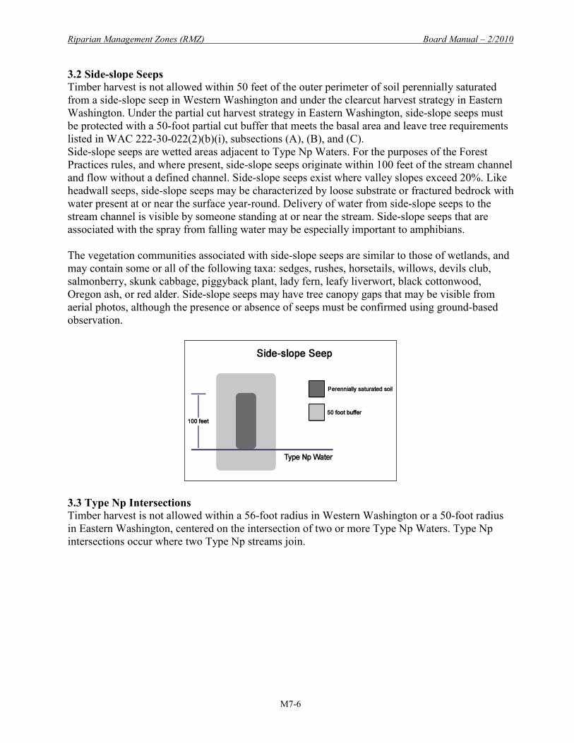
3.2 Side-slope Seeps Timber harvest is not allowed within 50 feet of the outer perimeter of soil perennially saturated from a side-slope seep in Western Washington and under the clearcut harvest strategy in Eastern Washington. Under the partial cut harvest strategy in Eastern Washington, side-slope seeps must be protected with a 50-foot partial cut buffer that meets the basal area and leave tree requirements listed in WAC 222-30-022(2)(b)(i), subsections (A), (B), and (C). Side-slope seeps are wetted areas adjacent to Type Np Waters. For the purposes of the Forest Practices rules, and where present, side-slope seeps originate within 100 feet of the stream channel and flow without a defined channel. Side-slope seeps exist where valley slopes exceed 20%. Like headwall seeps, side-slope seeps may be characterized by loose substrate or fractured bedrock with water present at or near the surface year-round. Delivery of water from side-slope seeps to the stream channel is visible by someone standing at or near the stream. Side-slope seeps that are associated with the spray from falling water may be especially important to amphibians. The vegetation communities associated with side-slope seeps are similar to those of wetlands, and may contain some or all of the following taxa: sedges, rushes, horsetails, willows, devils club, salmonberry, skunk cabbage, piggyback plant, lady fern, leafy liverwort, black cottonwood, Oregon ash, or red alder. Side-slope seeps may have tree canopy gaps that may be visible from aerial photos, although the presence or absence of seeps must be confirmed using ground-based observation.
3.3 Type Np Intersections Timber harvest is not allowed within a 56-foot radius in Western Washington or a 50-foot radius in Eastern Washington, centered on the intersection of two or more Type Np Waters. Type Np intersections occur where two Type Np streams join.

Board Manual – 2/2010 Riparian Management Zones (RMZ)
M7-7
3.4 Headwater Springs Timber harvest is not allowed within a 56-foot radius patch of a headwater spring in Western Washington, or within a 50-foot radius patch of a headwater spring in Eastern Washington. The radius patch is centered on the initiation point of perennial flow of a headwater spring, or in the absence of a spring, the uppermost point of perennial flow. Headwater springs are permanent springs that are located at the head of perennial channels where present and form the upper extent of a Type Np Water. Where these springs are present, they provide especially important amphibian habitat. During low flow periods, they are often observed as an abrupt small pool or riffle with flow where the channel is immediately and persistently dry above. Vegetation characteristics may not differ markedly from the taxa upstream and downstream. However, vegetation similar to that of headwall seeps and side-slope seeps may be present.
3.5 Alluvial Fans Timber harvest is not allowed on alluvial fans in Western Washington, or within 50 feet of an alluvial fan in Eastern Washington under the clearcut harvest strategy. An alluvial fan is defined as, “A low, outspread flat to gently sloping mass of loose rock material, shaped like an open fan…, deposited by a stream at the place where it issues from a narrow mountain valley or gorge

Riparian Management Zones (RMZ) Board Manual – 2/2010
M7-8
upon a plain or broad valley…” (Jackson 1997).2 An alluvial fan will form as a result of a change in slope at the mouth of a stream. As the stream issues onto a plain or broad valley it spreads out and slows down. Any solids entrained in the stream tend to settle out onto the gentle slopes of the plain or broad valley. These solids block the flow of the stream and cause the flow to change course. Therefore, due to the gentle topography on the plain or in the broad valley, alluvial fans are susceptible to stream channel migration. The fan shape forms by radial spreading as the stream migrates back and forth on the gentle slope and solid material is deposited in equal layers. These deposits gradually build up the surface of the fan. As a landform, alluvial fans are steepest at their high point (or apex) at the mouth of the narrow mountain valley or gorge from which the stream issues, and slope gently in a slightly mounded manner outward with gradually decreasing grade. Stream channels on a fan can vary and change without notice vacating established channels or scouring out new ones. A landslide in a narrow stream channel at or above the apex can influence the stream course by pre-depositional erosion and downcutting. It is the deposition of solids that most influences the direction a stream will take on the body of a fan. When a channel is blocked by deposition, the stream will change direction. For this reason, braided channels are common on alluvial fans. Alluvial fans may build up over thousands of years and be covered by trees. The roots of these trees can serve to stabilize fan channels.
2 Jackson, J. A., 1997, Glossary of Geology, 4th Edition, American Geological Institute, Alexandria, Virginia, 769 pp..
Board Manual – 2/2010 Riparian Management Zones (RMZ)
M7-9
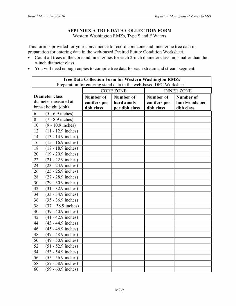
APPENDIX A TREE DATA COLLECTION FORM Western Washington RMZs, Type S and F Waters
This form is provided for your convenience to record core zone and inner zone tree data in preparation for entering data in the web-based Desired Future Condition Worksheet. • Count all trees in the core and inner zones for each 2-inch diameter class, no smaller than the
6-inch diameter class. • You will need enough copies to compile tree data for each stream and stream segment.
Tree Data Collection Form for Western Washington RMZs
Preparation for entering stand data in the web-based DFC Worksheet. Diameter class diameter measured at breast height (dbh)
CORE ZONE INNER ZONE Number of conifers per dbh class
Number of hardwoods per dbh class
Number of conifers per dbh class
Number of hardwoods per dbh class
6 (5 - 6.9 inches) 8 (7 - 8.9 inches) 10 (9 - 10.9 inches) 12 (11 - 12.9 inches) 14 (13 - 14.9 inches) 16 (15 - 16.9 inches) 18 (17 - 18.9 inches) 20 (19 - 20.9 inches) 22 (21 - 22.9 inches) 24 (23 - 24.9 inches) 26 (25 - 26.9 inches) 28 (27 - 28.9 inches) 30 (29 - 30.9 inches) 32 (31 - 32.9 inches) 34 (33 - 34.9 inches) 36 (35 - 36.9 inches) 38 (37 – 38.9 inches) 40 (39 - 40.9 inches) 42 (41 - 42.9 inches) 44 (43 - 44.9 inches) 46 (45 - 46.9 inches) 48 (47 - 48.9 inches) 50 (49 - 50.9 inches) 52 (51 - 52.9 inches) 54 (53 - 54.9 inches) 56 (55 - 56.9 inches) 58 (57 - 58.9 inches) 60 (59 - 60.9 inches)

Riparian Management Zones (RMZ) Board Manual – 2/2010
M7-10
APPENDIX B EXAMPLE OF DESIRED FUTURE CONDITION WORKSHEET DATA ENTRY PAGE AND SUMMARY PAGES
Desired Future Condition Worksheet Data Entry Page
Example: A 100-foot RMZ length on a site class III harvest unit, small stream

Board Manual – 2/2010 Riparian Management Zones (RMZ)
M7-11
Example Screen image after data entry: Option 1

Riparian Management Zones (RMZ) Board Manual – 2/2010
M7-12
Example Screen image after data entry: Option 2

Board Manual – 2/2010 Riparian Management Zones (RMZ)
M7-13
Example DFC Summary Printout Pages

Riparian Management Zones (RMZ) Board Manual – 2/2010
M7-14
Example
DFC Summary Printout Pages, continued – Option 1

Board Manual – 2/2010 Riparian Management Zones (RMZ)
M7-15
Example DFC Summary Printout Pages, continued – Option 2

Riparian Management Zones (RMZ) Board Manual – 2/2010
M7-16
APPENDIX C EASTERN WASHINGTON BASAL AREA AND LEAVE TREE TABLES This appendix contains a set of tables specific to each timber habitat and stream type. The tables provide basal area thresholds and leave tree estimates for a variety of RMZ lengths. You may compare these estimates with your stand characteristics to get a general idea whether harvest is likely to be allowed in your stand. Inner zone acreage calculations in the tables are rounded to the nearest hundredth (0.01) and tree and basal area counts are rounded to the nearest whole number. Numbers greater than or equal to 0.5 are rounded up, numbers less than or equal to 0.4 are rounded down. A. Type S and F Waters: Tables for Small Streams (streams ≤ 15 feet in bankfull width)
• Inner zone width is 45 feet. • 1000 feet RMZ length = approximately 1.03 acre
Table A1. Ponderosa pine (elevation ≤ 2500 feet) Length of RMZ (feet) 1000 900 800 700 600 500 400 300 200 100 Approximate inner zone acres
1.03 0.93 0.82 0.72 0.62 0.52 0.41 0.31 0.21 0.10
21 largest leave trees per acre
22 20 17 15 13 11 9 7 4 2
29 additional trees ≥ 10" dbh
30 27 24 21 18 15 12 9 6 3
Required leave trees basal area per acre (square feet)
62 56 49 43 37 31 25 19 13 6
Basal area upper threshold (square feet) 113 102 90 79 68 57 45 34 23 11
Table A2. Mixed conifer (elevation 2,500 to 5,000 feet) - Low site index (less than 90)
Length of RMZ (feet) 1000 900 800 700 600 500 400 300 200 100 Approximate inner zone acres
1.03 0.93 0.82 0.72 0.62 0.52 0.41 0.31 0.21 0.10
21 largest leave trees per acre
22 20 17 15 13 11 9 7 4 2
29 additional trees ≥ 10" dbh
30 27 24 21 18 15 12 9 6 3
Required leave trees basal area per acre (square feet)
72 65 57 50 43 36 29 22 15 7
Basal area upper threshold (square feet) 113 102 90 79 68 57 45 34 23 11

Board Manual – 2/2010 Riparian Management Zones (RMZ)
M7-17
Table A3. Mixed conifer (elevation 2,500 to 5,000 feet) - Medium site index (90-110) Length of RMZ (feet) 1000 900 800 700 600 500 400 300 200 100 Approximate inner zone acres
1.03 0.93 0.82 0.72 0.62 0.52 0.41 0.31 0.21 0.10
21 largest leave trees per acre
22 20 17 15 13 11 9 7 4 2
29 additional trees ≥ 10" dbh
30 27 24 21 18 15 12 9 6 3
Required leave trees basal area per acre (square feet)
93 84 74 65 56 47 37 28 19 9
Basal area upper threshold (square feet) 134 121 107 94 81 68 53 40 27 13
Table A4. Mixed conifer (elevation 2,500 to 5,000 feet) - High site index (greater than 110) Length of RMZ (feet) 1000 900 800 700 600 500 400 300 200 100 Approximate inner zone acres
1.03 0.93 0.82 0.72 0.62 0.52 0.41 0.31 0.21 0.10
21 largest leave trees per acre
22 20 17 15 13 11 9 7 4 2
29 additional trees ≥ 10" dbh
30 27 24 21 18 15 12 9 6 3
Required leave trees basal area per acre (square feet)
93 84 74 65 56 47 37 28 19 9
Basal area upper threshold (square feet) 155 140 123 108 93 78 62 47 32 15
B. Type S and F Waters: Tables for Large Streams (>15 feet in bankfull width)
• Inner zone width is 70 feet. • 1000 feet = 1.61 acres
Table B1. Ponderosa pine (elevation ≤ 2500 feet) Length of RMZ (feet) 1000 900 800 700 600 500 400 300 200 100 Approximate inner zone acres
1.61 1.45 1.29 1.13 0.97 0.81 0.64 0.48 0.32 0.16
21 largest leave trees per acre
34 30 27 24 20 17 13 10 7 3
29 additional trees ≥ 10" dbh
47 42 37 33 28 23 19 14 9 5
Required leave trees basal area per acre (square feet)
97 87 77 68 58 49 38 29 19 10
Basal area upper threshold (square feet) 177 160 142 124 107 89 70 53 35 18

Riparian Management Zones (RMZ) Board Manual – 2/2010
M7-18
Table B2. Mixed conifer (elevation 2,500 to 5,000 feet) - Low site index (less than 90)
Length of RMZ (feet) 1000 900 800 700 600 500 400 300 200 100 Approximate inner zone acres 1.61 1.45 1.29 1.13 0.97 0.81 0.64 0.48 0.32 0.16
21 largest leave trees per acre
34 30 27 24 20 17 13 10 7 3
29 additional trees ≥ 10" dbh
47 42 37 33 28 23 19 14 9 5
Required leave trees basal area per acre (square feet)
113 102 90 79 68 57 45 34 22 11
Basal area upper threshold (square feet) 177 160 142 124 107 89 70 53 35 18
Table B3. Mixed conifer (elevation 2,500 to 5,000 feet) - Medium site index (90-110)
Length of RMZ (feet) 1000 900 800 700 600 500 400 300 200 100 Approximate inner zone acres
1.61 1.45 1.29 1.13 0.97 0.81 0.64 0.48 0.32 0.16
21 largest leave trees per acre
34 30 27 24 20 17 13 10 7 3
29 additional trees ≥ 10" dbh
47 42 37 33 28 23 19 14 9 5
Required leave trees basal area per acre (square feet)
145 131 116 102 87 73 58 43 29 14
Basal area upper threshold (square feet) 209 189 168 147 126 105 83 62 42 21
Table B4. Mixed conifer (elevation 2,500 to 5,000 feet) - High site index (greater than 110)
Length of RMZ (feet) 1000 900 800 700 600 500 400 300 200 100 Approximate inner zone acres
1.61 1.45 1.29 1.13 0.97 0.81 0.64 0.48 0.32 0.16
21 largest leave trees per acre
34 30 27 24 20 17 13 10 7 3
29 additional trees ≥ 10" dbh
47 42 37 33 28 23 19 14 9 5
Required leave trees basal area per acre (square feet)
145 131 116 102 87 73 58 43 29 14
Basal area upper threshold (square feet) 242 218 194 170 146 122 96 72 48 24
Board Manual – 2/2010 Riparian Management Zones (RMZ)
M7-19
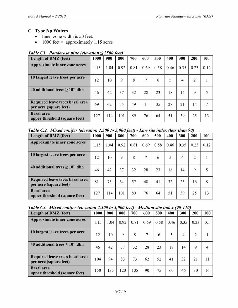
C. Type Np Waters • Inner zone width is 50 feet. • 1000 feet = approximately 1.15 acres
Table C1. Ponderosa pine (elevation ≤ 2500 feet)
Length of RMZ (feet) 1000 900 800 700 600 500 400 300 200 100 Approximate inner zone acres
1.15 1.04 0.92 0.81 0.69 0.58 0.46 0.35 0.23 0.12
10 largest leave trees per acre
12 10 9 8 7 6 5 4 2 1
40 additional trees ≥ 10" dbh
46 42 37 32 28 23 18 14 9 5
Required leave trees basal area per acre (square feet) 69 62 55 49 41 35 28 21 14 7
Basal area upper threshold (square feet) 127 114 101 89 76 64 51 39 25 13
Table C.2. Mixed conifer (elevation 2,500 to 5,000 feet) - Low site index (less than 90)
Length of RMZ (feet) 1000 900 800 700 600 500 400 300 200 100 Approximate inner zone acres
1.15 1.04 0.92 0.81 0.69 0.58 0.46 0.35 0.23 0.12
10 largest leave trees per acre
12 10 9 8 7 6 5 4 2 1
40 additional trees ≥ 10" dbh
46 42 37 32 28 23 18 14 9 5
Required leave trees basal area per acre (square feet) 81 73 64 57 48 41 32 25 16 8
Basal area upper threshold (square feet) 127 114 101 89 76 64 51 39 25 13
Table C3. Mixed conifer (elevation 2,500 to 5,000 feet) - Medium site index (90-110)
Length of RMZ (feet) 1000 900 800 700 600 500 400 300 200 100 Approximate inner zone acres
1.15 1.04 0.92 0.81 0.69 0.58 0.46 0.35 0.23 0.1
10 largest leave trees per acre
12 10 9 8 7 6 5 4 2 1
40 additional trees ≥ 10" dbh
46 42 37 32 28 23 18 14 9 4
Required leave trees basal area per acre (square feet) 104 94 83 73 62 52 41 32 21 11
Basal area upper threshold (square feet) 150 135 120 105 90 75 60 46 30 16
Riparian Management Zones (RMZ) Board Manual – 2/2010
M7-20
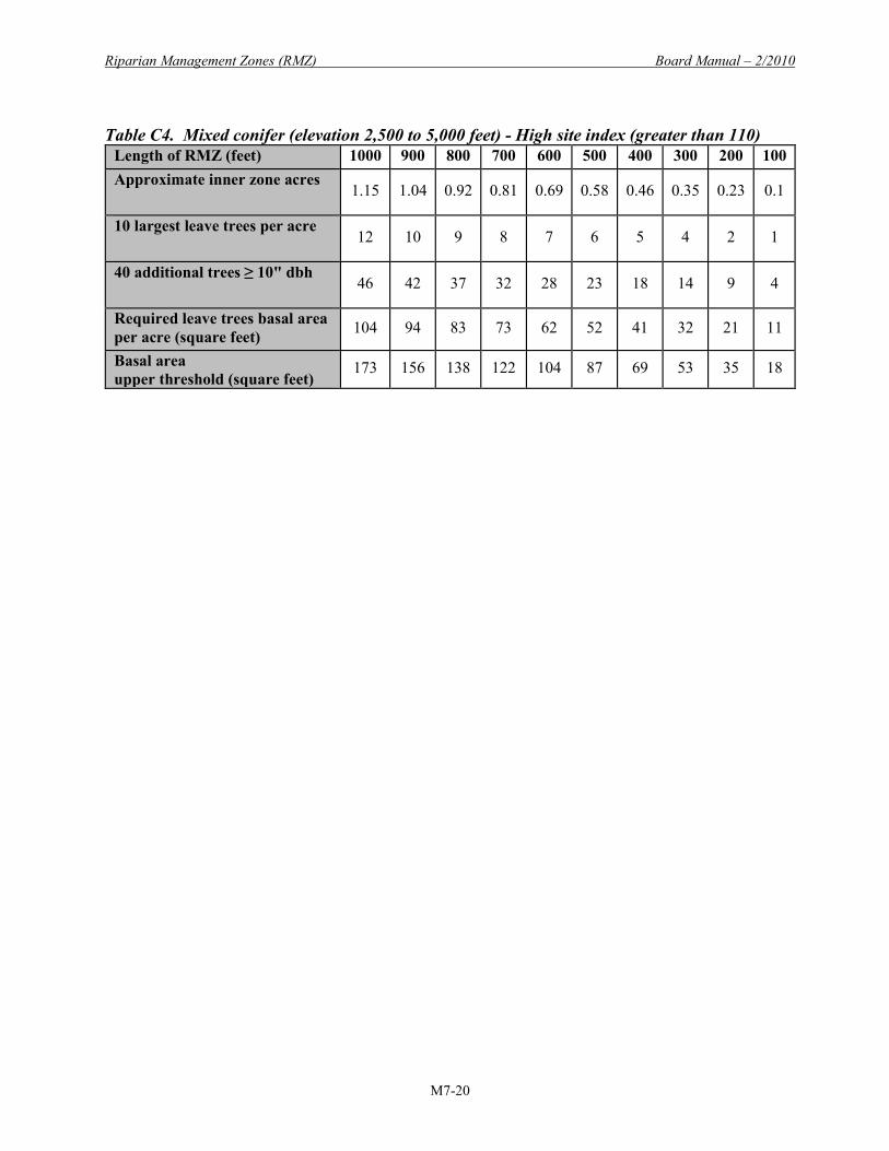
Table C4. Mixed conifer (elevation 2,500 to 5,000 feet) - High site index (greater than 110)
Length of RMZ (feet) 1000 900 800 700 600 500 400 300 200 100 Approximate inner zone acres
1.15 1.04 0.92 0.81 0.69 0.58 0.46 0.35 0.23 0.1
10 largest leave trees per acre
12 10 9 8 7 6 5 4 2 1
40 additional trees ≥ 10" dbh
46 42 37 32 28 23 18 14 9 4
Required leave trees basal area per acre (square feet) 104 94 83 73 62 52 41 32 21 11
Basal area upper threshold (square feet)
173 156 138 122 104 87 69 53 35 18

Board Manual – 2/2010 Riparian Management Zones (RMZ)
M7-21
APPENDIX D EASTERN WASHINGTON RMZS, TYPE S AND F WATERS
This appendix contains guidelines for assessing the inner zone timber and associated basal areas for Eastern Washington RMZs adjacent to Type S and F Waters. The rules for Eastern Washington RMZs vary by timber habitat type:
• Ponderosa pine timber habitat type (stands below 2,500 feet in elevation); • Mixed conifer timber habitat type (stands 2,500 to 5,000 feet in elevation); and • High elevation timber habitat type (stands above 5,000 feet).
The guidelines in this appendix are for the Ponderosa pine and mixed conifer types. For the high elevation timber habitat type, the stand requirement is the same as for Western Washington Type S and F Waters; therefore, the Western Washington guidelines (Part 2 of this manual) should be followed. Section 1 is provided to help you calculate the basal area per acre in your stand. Harvest in the inner zone is allowed if the inner zone basal area per acre exceeds a basal area requirement. The result of your calculation in Section 1 can be compared with the basal area requirement from the rules, which you will find in Section 2 of this appendix. Comparing the basal area of the trees in your stand with the basal area requirement will help you to determine if harvest will be allowed in your stand. If so, you can refer to Section 2 to find your leave tree requirements. Then you can use Section 3 for calculating your leave trees. Section 4 provides an example of calculations for a two-acre inner zone to demonstrate how to calculate leave trees. Section 1. Inner zone assessment. You may use Table 1 on the following page to collect tree data that will help assess whether harvest will be allowed in the inner zone.

Riparian Management Zones (RMZ) Board Manual – 2/2010
M7-22
Table 1 Inner Zone Assessment
Collect tree data for trees in each 2-inch diameter class, no smaller than the 6-inch diameter class.
A B C D Diameter class diameter measured at breast height (dbh)
Basal area per tree (square feet)
Number of trees in the inner zone
Basal area per dbh class (square feet) (multiply numbers in columns B and C)
32 (31 - 32.9 inches) 5.6
30 (29 - 30.9 inches) 4.9
28 (27 - 28.9 inches) 4.3
26 (25 - 26.9 inches) 3.7
24 (23 - 24.9 inches) 3.1
22 (21 - 22.9 inches) 2.6
20 (19 - 20.9 inches) 2.2
18 (17 - 18.9 inches) 1.8
16 (15 - 16.9 inches) 1.4
14 (13 - 14.9 inches) 1.1
12 (11 - 12.9 inches) 0.79
10 (9 - 10.9 inches) 0.55
8 (7 - 8.9 inches) 0.35
6 (5 - 6.9 inches) 0.20
If your harvest unit contains more than one stream or stream segment, this analysis should be done separately for each segment.
Calculate the basal area per acre in the inner zone. Add the basal areas in column D for a total basal area in the inner zone. _____ sq. ft. Divide the total basal area by the acres in the inner zone.3 Total basal area _______sq. ft. ÷ _______ acres = _______ Basal area per acre Calculate trees per acre in the inner zone. Add the number of trees in column C. __________ total trees Divide the total trees by acres in the inner zone. 3 To calculate inner zone acres, multiply the inner zone width (45 feet for streams ≤ 15 feet, or 70 feet for streams >15 feet) by the inner zone length, then divide by 43,560: Inner zone acres = width _______ feet X length ______ feet ÷ 43,560.

Board Manual – 2/2010 Riparian Management Zones (RMZ)
M7-23
Total trees ________ trees ÷ ______ acres = ________ trees per acre Next, compare your inner zone basal area and trees per acre with the requirements for your timber habitat type shown in Section 2. Then use Section 3 for help in determining your leave tree requirement. Section 2. Basal area and leave tree requirements. Ponderosa pine timber habitat type (stands below 2,500 feet in elevation). 1. Stands with high basal area.
Basal area requirement. Harvest is allowed if the basal area is more than 110 square feet per acre for all tree species equal to or greater than 6 inches dbh in the inner zone.
Leave tree requirements. Harvest must leave at least 50 trees per acre and a basal area of at least 60 sq. ft./ac. You must select leave trees as follows: • 21 largest trees per acre; and • An additional 29 trees per acre that are ≥ 10 inches dbh If there are fewer than 29 ≥ 10-inch dbh trees per acre, leave the 29 largest trees. If there are more than 29 ≥ 10-inch dbh trees per acre, leave 29
≥ 10-inch dbh trees per acre based on the following priority order: Trees that provide shade to water; Trees that lean towards the water; Trees of the preferred species as defined in WAC 222-16-010; Trees that are evenly distributed across the inner zone.
If more than 50 trees per acre are needed to meet the minimum leave tree basal area of 60 square feet per acre, then additional trees ≥ 6 inches dbh must be left. If the minimum basal area cannot be met with fewer than 100 trees that are ≥ 6 inches dbh, then no more than 100 trees per acre of the largest remaining trees are required to be left regardless of basal area.
2. Stands with low basal area and high density.
Basal area and density requirements. Thinning is permitted if the basal area of all species is less than 60 square feet per acre AND there are more than 100 trees per acre.
Leave tree requirements. Thinning in low basal area and high density stands must leave a minimum of 100 trees per acre. The trees to be left shall be selected as follows: • The 50 largest trees per acre; and • An additional 50 trees per acre in the 6-inch diameter class or larger. If there are not 50
trees per acre in the 6-inch diameter class or larger, then all trees in the 6-inch diameter class or larger per acre must be left, plus the largest remaining trees to equal 50 trees per acre. Select the additional 50 trees per acre based on the following priority order: Trees that provide shade to water; Trees that lean towards the water; Trees of the preferred species as defined in WAC 222-16-010; Trees that are evenly distributed across the inner zone.

Riparian Management Zones (RMZ) Board Manual – 2/2010
M7-24
Mixed conifer timber habitat type (stands 2,500 to 5,000 feet in elevation). The rules for the mixed conifer timber habitat type require knowledge of the site index of a harvest unit. For purposes of carrying out the RMZ rules, site indices are reported in the Washington State Department of Natural Resources State Soil Survey and detailed in the associated forest soil summary sheets. Contact a Department of Natural Resources (DNR) region office for site index information. If the soil survey does not report a site index for your location or it indicates noncommercial or marginal forest land, then see (3) of the definition of “site class” in WAC 222-16-010 for guidance. 1. Stands with high basal area.
Basal area requirement. Harvest is allowed if the total basal area of all species greater than 6 inches dbh in the inner zone is more than: 100 sq. ft./ac. on low site index (< 90) 130 sq. ft./ac. on medium site index (90 to ≤ 110) 150 sq. ft./ac. on high site index (> 110)
Leave tree requirements. Harvest must leave at least 50 trees per acre AND a basal area of at least: 70 sq. ft./ac. on low site index (< 90) 90 sq. ft./ac. on medium site index (90 to ≤ 110) 110 sq. ft./ac. on high site index (> 110)
The trees to be left shall be selected as followed: • 21 largest trees per acre • An additional 29 trees per acre that are ≥ 10 inches dbh If there are fewer than 29 ≥ 10-inch trees per acre, leave the 29 largest trees. If there are more than 29 ≥ 10-inch trees per acre, leave 29 ≥ 10-inch dbh trees per
acre based on the following priority order: Trees that provide shade to water; Trees that lean towards the water; Trees of the preferred species as defined in WAC 222-16-010; Trees that are evenly distributed across the inner zone.
If more than 50 trees per acre are needed to meet the minimum leave tree basal area for the applicable site index, then additional trees ≥ 6 inches dbh must be left. If the minimum basal area cannot be met with fewer than 100 trees that are ≥ 6 inches dbh, then no more than 100 trees per acre of the largest remaining trees are required to be left regardless of basal area.
2. Stands with low basal area and high density.
Basal area and density requirements. Thinning is permitted if the basal area of all species in the inner zone is less than the minimum requirements for the site index (as shown below) AND there are more than 120 trees per acre:

Board Manual – 2/2010 Riparian Management Zones (RMZ)
M7-25
70 sq. ft./ac. on low site index (< 90) 90 sq. ft./ac. on medium site index (90 to ≤ 110) 110 sq. ft./ac. on high site index (> 110)
Leave tree requirements. Thinning in low basal area and high density stands must leave a minimum of 120 trees per acre. The trees to be left shall be selected as follows: • The 50 largest trees per acre; and • An additional 70 trees per acre in the 6-inch diameter class or larger. If there are not 70
trees per acre in the 6-inch diameter class or larger, then all trees in the 6-inch diameter class or larger per acre must be left, plus the largest remaining trees to equal 70 trees per acre. Select the additional 70 trees per acre based on the following priority order: Trees that provide shade to water; Trees that lean towards the water; Trees of the preferred species as defined in WAC 222-16-010; Trees that are evenly distributed across the inner zone.
Additional Leave Tree Requirements. The 21 largest trees do not have to be evenly spaced. The 29 additional ≥ 10-inch dbh trees per acre should be selected based on the following priority order:
• Trees that provide shade to water. • Trees that lean toward the water. • Trees of the preferred species:
Ponderosa pine habitat type All hardwoods, Ponderosa pine, western larch, Douglas-fir, western red cedar Mixed conifer habitat type All hardwoods, western larch, Ponderosa pine, western red cedar, western white pine, Douglas-fir, lodgepole pine
• Trees that are evenly spaced across the inner zone. Section 3. Leave tree calculations. This is a worksheet for calculating leave trees on stands with high basal area. It will help to determine your 21 largest leave trees per acre, the additional 29 leave trees per acre, and the basal areas of those leave trees. To determine how many of the largest trees are you are required to leave in the inner zone, multiply 21 by inner zone acres. 21 trees X _______ acres = _______ trees
Calculate the basal area per acre of the 21 largest leave trees per acre:
• Transfer the information you collected in Section 1 Table 1 to Table 3.1 below, starting with the largest trees and proceeding in descending order until you reach the number of the largest trees you calculated above.

Riparian Management Zones (RMZ) Board Manual – 2/2010
M7-26
Table 3.1
21 Largest Leave Trees Per Acre A B C D
Diameter class diameter measured at breast height (dbh)
Basal area per tree (square feet)
Number of trees in the inner zone
Basal area per dbh class (square feet) (multiply numbers in columns B and C)
• Total the numbers in column D. ________ sq. ft. total basal area. • Divide the total basal area by inner zone acres.
_______sq. ft. ÷ _______ acres = _________ sq. ft. basal area per acre (BA/ac.). Next, determine the 29 additional leave trees per acre you are required to leave in the inner zone that are ≥ 10 inches dbh: Multiply 29 by inner zone acres. 29 trees X _______ acres = ______ trees Calculate the basal area per acre of the additional 29 leave trees per acre.
• Transfer information you collected in Section 1 Table 1 to Table 3.2 below, starting with the 10-inch dbh class and proceeding in ascending order until you reach the number of additional trees you calculated above. If there are fewer than 29 trees per acre ≥ 10 inches dbh in your stand, include the 29 next largest additional trees in this calculation.
Table 3.2 Additional 29 Leave Trees Per Acre
A B C D Diameter class diameter measured at breast height (dbh)
Basal area per tree (square feet)
Number of trees in the inner zone
Basal area per dbh class (square feet) (multiply numbers in columns B and C)

Board Manual – 2/2010 Riparian Management Zones (RMZ)
M7-27
• Total the numbers in column D. ________ sq. ft. total basal area. • Divide the total basal area by inner zone acres. _______sq. ft. ÷ _______ acres = _________ sq. ft. basal area per acre (BA/ac.).
Now calculate the total basal area per acre of all leave trees. BA/ac. of largest trees______ + BA/ac. of additional trees______ =______total sq. ft. BA/ac. Compare this total with the basal area requirement for your stand habitat type. If more than 50 trees per acre are needed to meet the minimum leave tree basal area for the applicable site index, then additional trees ≥ 6 inches dbh must be left. If the minimum basal area cannot be met with fewer than 100 trees that are ≥ 6 inches dbh, then no more than 100 trees per acre of the largest remaining trees are required to left regardless of basal area. Section 4. EXAMPLE for a 2-acre inner zone in the Ponderosa pine timber habitat type.
Table 1 Inner Zone Assessment
Collect tree data for trees in each 2-inch diameter class, no smaller than the 6-inch diameter class.
A B C D Diameter class diameter measured at breast height (dbh)
Basal area per tree (square feet)
Number of trees in the inner zone
Basal area per dbh class (square feet) (multiply numbers in columns B and C)
32 (31 - 32.9 inches) 5.6 30 (29 - 30.9 inches) 4.9 28 (27 - 28.9 inches) 4.3 26 (25 - 26.9 inches) 3.7 8 29.6 24 (23 - 24.9 inches) 3.1 8 24.8 22 (21 - 22.9 inches) 2.6 10 26 20 (19 - 20.9 inches) 2.2 20 44 18 (17 - 18.9 inches) 1.8 20 36 16 (15 - 16.9 inches) 1.4 15 21 14 (13 - 14.9 inches) 1.1 30 33 12 (11 - 12.9 inches) 0.79 40 31.6 10 (9 - 10.9 inches) 0.55 40 22 8 (7 - 8.9 inches) 0.35 50 17.5 6 (5 - 6.9 inches) 0.20 60 12
Calculate the basal area per acre (BA/ac.) in the inner zone. Add the basal areas in column D for a total basal area in the inner zone: 297.5 sq. ft.

Riparian Management Zones (RMZ) Board Manual – 2/2010
M7-28
Divide the total basal area by the acres in the inner zone: 297.5 sq. ft. ÷ 2 acres = 148.8 sq. ft. BA/ac. Calculate trees per acre in the inner zone. Add the number of trees in column C: 301 total trees Divide the total trees by acres in the inner zone: 301 trees ÷ 2 acres = 150.5 trees per acre In this example, harvest is allowed in the inner zone because the basal area per acre in this 2-acre inner zone exceeds the requirement of 110 sq. ft. per acre for the Ponderosa pine timber habitat type. It is also evident that the number of trees per acre in the stand exceeds the minimum leave tree requirement of 50 trees per acre. Now the leave trees will be identified. Determine the number of largest trees to be left: 21 trees X 2 acres = 42 trees
Table 3.1
21 Largest Leave Trees Per Acre A B C D
Diameter class diameter measured at breast height (dbh)
Basal area per tree (square feet)
Number of trees in the inner zone
Basal area per dbh class (square feet) (multiply numbers in columns B and C)
26 3.7 8 29.6 24 3.1 8 24.8 22 2.6 10 26.0 20 2.2 16 35.2
Total the numbers in column D. 115.6 sq. ft. basal area Divide the total basal area by inner zone acres: 115.6 sq. ft. ÷ 2 acres = 57.8 sq. ft. BA/ac. Calculate the number of additional trees ≥ 10 inches dbh to be left: 29 trees X 2 acres = 58 trees
Table 3.2 Additional 29 Leave Trees Per Acre
A B C D Diameter class diameter measured at breast height (dbh)
Basal area per tree (square feet)
Number of trees in the inner zone
Basal area per dbh class (square feet) (multiply numbers in columns B and C)
10 .55 40 22.0 12 .79 18 14.2

Board Manual – 2/2010 Riparian Management Zones (RMZ)
M7-29
Total the numbers in column D. 36.2 sq. ft. basal area Divide the total basal area by inner zone acres: 36.2 sq. ft. ÷ 2 acres = 18.2 sq. ft. BA/ac. Total the basal area per acre of the 21 largest trees per acre plus the 29 additional leave trees per acre: BA/ac. of 21 largest trees per acre 57.8 + BA/ac. of additional 29 trees per acre 18.2 = 76 sq. ft. total BA/ac. In this example, the total basal area per acre of the 50 required leave trees per acre is 76 sq. ft. This meets the leave tree requirement for a stand with high basal area in the Ponderosa pine timber habitat type.


