Section 4: Design Concepts - Cobb County, Georgia Design Concepts Development In order to achieve...
12
Section 4: Design Concepts
Transcript of Section 4: Design Concepts - Cobb County, Georgia Design Concepts Development In order to achieve...

Section 4: Design Concepts

31
Design Concepts Development In order to achieve the goals of the Urban Design Plan, the community identified safety, access, connectivity, retail uses, public realm and identity as key areas of focus. In doing so, staff developed an overall concept plan based on the results of the design charrette workshop. In addition to this overall plan, three design alternatives were presented to the public and steering committee. These concepts provided further direction on how the future community can be connected, become more pedestrian friendly and increase accessibility. The following diagrams, Alternative Design Concepts, show each alternative as presented. The design phase of the project was, to date, the most data intensive portion of the study. Staff, as well as stakeholders, worked together in constructing a framework for the public to participate and direct the process. This was done to ensure the community’s vision and desires were incorporated into the corridor plan. Three tools were employed to develop the design concept: staff conducted an image preference survey; SWOT Analysis (Strategic Planning); and a design charrette. Based on these results, a combination of images, street design and activity nodes were examined and later presented in the form of distinct design alternatives for the community to choose. The three design alternatives include the Concentric Design, the Internal Link Design and the Perimeter Design. Each present to the community concepts to consider along with the potential future land use implications. The Concentric Design is the most liked among the three design alternatives. This is mainly due to the ease of implementation and lowest associated cost for implementation. This design is least disruptive to the current retail operations and provided the easiest transition from commercial to residential areas. This design improves accessibility and connectivity for pedestrians. The second alternative is the Internal link Design. This design is more appropriate in bigger lots and shopping centers and is best used to improve inter-parcel access along Johnson Ferry Road; thus improving connectivity throughout the entire corridor. In this case, walkability on Johnson Ferry Road is shifted to the internal link street locations. To further describe the internal link, it is a street located between shopping areas using existing parking spaces and impervious surfaces. There is little to no impact on the residential area and this alternative is the second choice by the community. Finally, the Perimeter Design provides a smooth and continuous street alternative to Johnson Ferry Road. It reduces the ingress and egress of local traffic on Johnson Ferry Road and links the residential community to the commercial community as it creates a new traffic linkage behind the commercial areas. This alternative is the least liked concept of the three presented and the most costly to implement. The community’s concern about this alternative is based upon additional cars and traffic that will be encouraged adjacent to residential communities. Based on the abovementioned design alternatives, the final vision was developed. The detailed information of these alternatives will be discussed later in the report.
Design Concepts

32
Design Concepts Development (Continued) This vision determines a hierarchy of activity nodes and the design alternative that best suite each node. This integration of street design and activity node vision assisted staff in determining how each area’s unique character connected to the others throughout the corridor. The largest activity node is located to the north at the intersection of Johnson Ferry Road and Roswell Road. The Concentric Design is proposed here. The second and medium sized node incorporates some aspects of the Concentric and Perimeter Designs and is located at Johnson Ferry Road and Lower Roswell Road. The southern most activity node is at the Johnson Ferry Road and Paper Mill Road intersection. The Internal Link is the choice of design to improve connectivity in this node. A final step in creating the vision is developed by mapping and overlaying each alternative, identifying activity nodes, unique corridor characteristic, highlighting areas needing improvements and signifying areas to be left unchanged. In addition, staff has identified and mapped all sidewalk improvements, bike lane additions, gateway and landmark areas, inter-parcel and property connections, landscape improvements and visual corridor area, as well as, locations for green space and possible pedestrian bridges. Once these components are mapped and fused together, a clear vision is identified for the corridor. This new vision reveals a high priority for multi-modal safety, improved connectivity between shopping, commercial and recreation areas, landscaping for the entire corridor and creating public gathering spaces. The public-at-large indicated a desire and immediate need for corridor beautification. This edict was repeated throughout the entire course of the first three project phases. Based on these recommendations two scales’ plans were developed, 1) the final design plan and 2) the street section design. The final design plan incorporates the best fit of each design concept and detailed street section design enhance the unique character of each area or corridor district as will be discussed later in this report.
Design Concepts
Map 27

33
Overall Design Alternatives � Concentric Design (See Map 28: Overall Street Framework, Map 29: Land Use )
• Developing grid and concentric street pattern in major commercial nodes, which helps focus business activities on the nodes
and alleviate the traffic burden at major intersections.
• Focus on the accessibility and connectivity for both pedestrian and local traffic in major nodes and shopping center areas.
• Slip lane design separates local traffic from pass through traffic on Johnson Ferry Road
• On-street parking along slip lanes provides convenient on-street parking spaces, slows down traffic flow on the locally serving
slip lanes, and creates a buffer between the traffic lanes and sidewalk to enhance walkability.
• Public transit located along Johnson Ferry Road can be improved by incorporating it into the future design schematics. The
station design can be associated with the on-street parking design to make transit operation more efficient.
• Focus on the beatification and functionalizing of Johnson Ferry Road to build a distinct character.
• Provide easier transition from existing commercial to surrounding residential neighborhood. This will create less conflict with
residential areas.
• Easiest to implement with the least impact on Johnson Ferry Road study area property owners among three alternatives.
• Cons
- Least amount of connectivity is provided as comparison with other two alternatives.
- No alternative north-south route is provided for Johnson Ferry Road.
- Least amount of new infrastructure improvements is needed to implement this design.
Design Concepts

34
�
Map 28 Map 29
Design Concepts

35
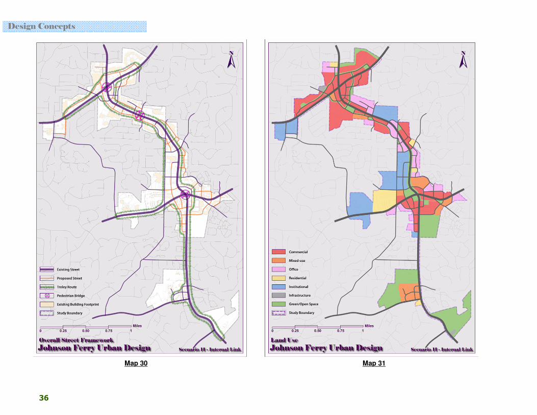
Overall Design Alternatives (Continued) � Internal Link Design (See Map 30: Overall Street Framework, Map 31: Land Use )
• The purpose of the Internal Link is to split big parcels into smaller blocks. It provides the best connectivity and accessibility to
each property and to the street throughout the whole corridor among the three alternatives.
• Use existing impervious surfaces to create continuous traffic lanes in the middle of large parcels between shopping malls and
small linear commercial properties fronting Johnson Ferry Road.
• Some links can act as controlled access drives that will serve local traffic and improve pedestrian and bicycle connectivity.
Other links may be inter-parcel access drives to connect adjacent commercial properties.
• Desirable walking space can be shifted from Johnson Ferry Road to Internal Link by incorporating green infrastructure into
the new link road. This green link can help build a pleasing pedestrian environment by adding shade to the route.
• Speed bumps, stop signs, and different texture of pavement, can be used on the Internal Links to slow down traffic creating a
safer and more pedestrian friendly atmosphere.
• Public transit can run on Internal Link lanes rather than on Johnson Ferry Road.
• The Internal Link will have little to no impact on adjacent residential properties.
• Cons
- This design will incorporate fewer character changes on Johnson Ferry Road.
- Block sizes may be too small for new viable retail establishments.
- Current small retail establishments need to be reoriented to face the internal links and/or Johnson Ferry Road,
otherwise they become less visible. If the block is only big enough to comprise of one building, the building needs to
have two façades to face both Johnson Ferry Road and the Internal Link streets.
- No on-street parking on Johnson Ferry Road is needed with this design; as a result, it will remain an automobile
oriented corridor.
Design Concepts
36
�
Map 30 Map 31
Design Concepts

37
Overall Design Alternatives (Continued) � Perimeter Design (See Map 32: Overall Street Framework, Map 33: Land Use )
• Create continuous local traffic lanes behind existing commercial properties.
• Public transit links all commercial and public institutions by locating the stops on some of the perimeter streets and extending
east and west on Upper and Lower Roswell Road.
• The perimeter design creates the best and most functional block size of all three scenarios for new commercial development.
• Keep the existing building environment relatively intact inside of the blocks.
• Provide a chance to link to adjacent residential community, where appropriate.
• The 1985 JFR corridor study used a similar perimeter link design for some areas of the road way (See Map 1, page 1).
• Cons
- Cars may be too close to neighboring residential tracts which may raise noise levels, safety and air quality issues.
Therefore, it would be more intrusive on surrounding residential community.
- The Perimeter Design is the hardest and most expensive to implement of the alternatives.
- Some areas have insufficient depth and distance to put in new streets between commercial and residential.
- For buildings on perimeter streets, an additional cost may be necessary to convert the building back façade to appear
as a front facing facade.
- Mandatory buffering will be required between residential and commercial properties to protect neighboring residential
uses, which would increase cost of implementation.
Design Concepts

38
Map 32 Map 33
Design Concepts

39
Merchants Walk Site Plan As part of the Project Management Team’s exploration of alternatives a hypothetical retrofit for the Merchant’s Walk Mall Shopping Center was proposed. This was created to gain an understanding of how the various ideas, developed with the community, would impact some of the larger commercial tracts along the corridor. This provided staff with the opportunity to test various ideas to understand their impacts, both for the community and for the individual property owners (See Map 34: Merchant Walk Site Plan).
• Maintain the major anchor stores in their existing locations (usually far away from the street with large areas of parking enfronting the building)
• Allocate new commercial buildings close to Johnson Ferry Road, which will create a pedestrian friendly shopping environment
• Continue the linear building arrangement at shopping center entrances to create a link with the major anchor stores with well-designed green infrastructures
• In most cases, surface parking to be located behind the linear commercial buildings.
• On-street parking on secondary streets is encouraged
• Internal link or inter-parcel access points expanded, which will allow for curb cuts to be minimized along the corridor
• Where possible, incorporate service, loading, and delivery to the back alleys
• Investigate potential locations for parking decks, whether they are new construction or convert existing space to layered parking opportunities.
Map 34
Design Concepts
40
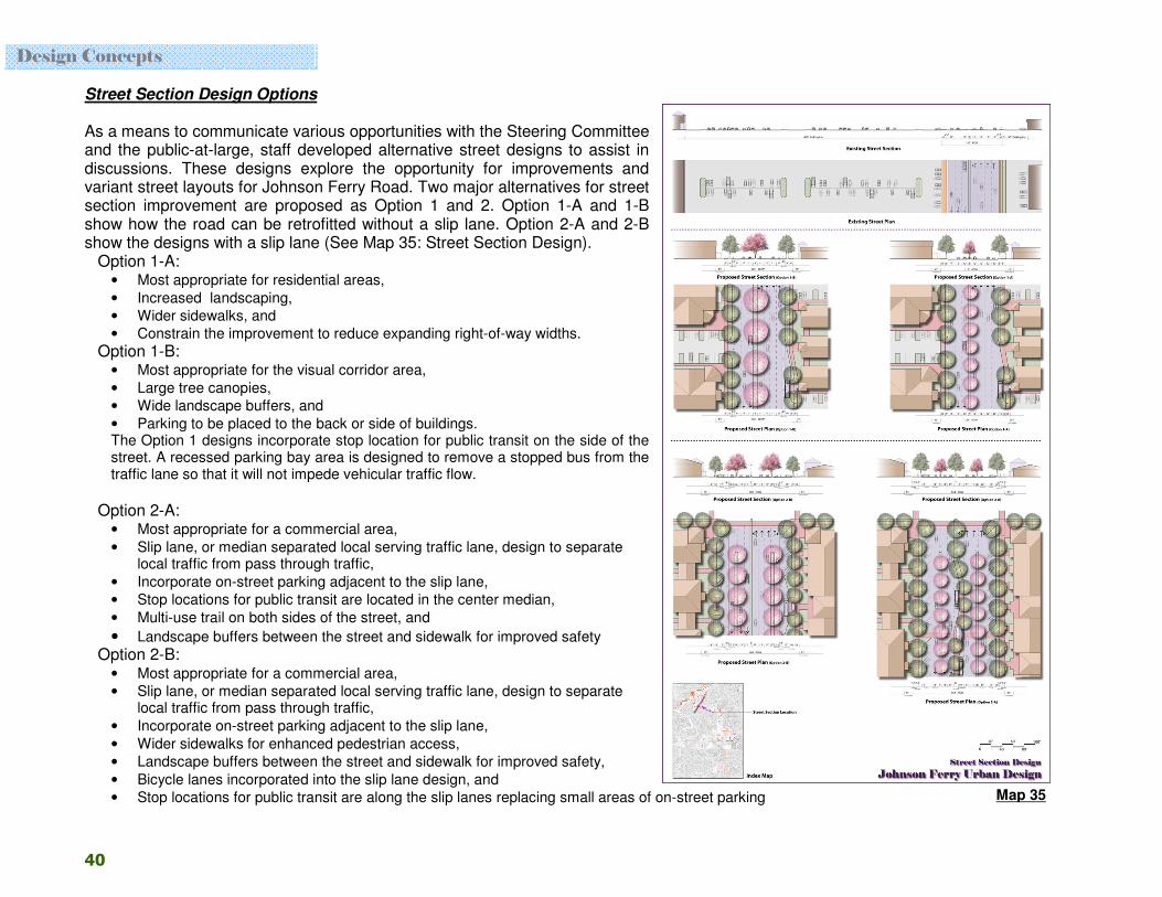
Street Section Design Options As a means to communicate various opportunities with the Steering Committee and the public-at-large, staff developed alternative street designs to assist in discussions. These designs explore the opportunity for improvements and variant street layouts for Johnson Ferry Road. Two major alternatives for street section improvement are proposed as Option 1 and 2. Option 1-A and 1-B show how the road can be retrofitted without a slip lane. Option 2-A and 2-B show the designs with a slip lane (See Map 35: Street Section Design).
Option 1-A: • Most appropriate for residential areas,
• Increased landscaping,
• Wider sidewalks, and
• Constrain the improvement to reduce expanding right-of-way widths.
Option 1-B: • Most appropriate for the visual corridor area,
• Large tree canopies,
• Wide landscape buffers, and
• Parking to be placed to the back or side of buildings. The Option 1 designs incorporate stop location for public transit on the side of the street. A recessed parking bay area is designed to remove a stopped bus from the traffic lane so that it will not impede vehicular traffic flow.
Option 2-A:
• Most appropriate for a commercial area,
• Slip lane, or median separated local serving traffic lane, design to separate local traffic from pass through traffic,
• Incorporate on-street parking adjacent to the slip lane,
• Stop locations for public transit are located in the center median,
• Multi-use trail on both sides of the street, and
• Landscape buffers between the street and sidewalk for improved safety Option 2-B:
• Most appropriate for a commercial area,
• Slip lane, or median separated local serving traffic lane, design to separate local traffic from pass through traffic,
• Incorporate on-street parking adjacent to the slip lane,
• Wider sidewalks for enhanced pedestrian access,
• Landscape buffers between the street and sidewalk for improved safety,
• Bicycle lanes incorporated into the slip lane design, and
• Stop locations for public transit are along the slip lanes replacing small areas of on-street parking Map 35
Design Concepts