Section 2 Part 1 Ohio HIRAema.ohio.gov/Documents/OhioMitigationPlan/SOHMP_Sec_2_5.pdf · Section 2:...
12
State of Ohio Hazard Mitigation Plan Section 2: Hazard Identification & Risk Assessment 126 2.5 LANDSLIDE A landslide is the downward and outward movement of soil and rock material on slopes. There are three main types of landslides that occur in Ohio: • Rotational Slump: the movement of a mass of weak rock or sediment as a block unit along a curved slip plane (Figure 2.5.1.a). In Ohio, these types of slides commonly involve hundreds of thousands of cubic yards of material and extend for hundreds of feet. The crown or head, located in the upper section of the ground surface, consists of one or more rupture zones (scarps) that form a stair-step pattern of displaced blocks. The surfaces of these blocks are commonly rotated backward (reverse slope) and form depressions along which water may accumulate, creating small ponds or swampy areas. Trees on these blocks may be inclined upslope, toward the top of the hill. The lower, downslope end (toe) of a rotational slump is a fan-shaped, bulging mass of material characterized by radial ridges and cracks. Trees on this portion of the landslide may be inclined at strange angles, giving rise to the descriptive terms "drunken" or "staggering" forest. Rotational slumps may develop comparatively slowly and commonly require several months or even years to reach stability; however, on occasion, they may move rapidly, achieving stability in only a few hours. • Earthflow: involves rock, sediment, or weathered surface materials moving downslope in a mass. The most common form of earth movement in Ohio, earthflow involves a smaller area than a rotational slump and forms a hummocky topography of ridges and swales. Trees may be inclined at odd angles throughout the length of an earthflow. Earthflows are most common in weathered surface materials, do not necessarily indicate weak rock, and are also common in unconsolidated glacial sediments. The rate of movement of an earthflow is generally quite slow. • Rockfall: an extremely rapid, potentially dangerous downslope movement of earth materials. Large blocks of massive bedrock suddenly become detached from a cliff or steep hillside and free fall in a rolling, bounding, or sliding manner downslope. Most rockfalls in Ohio involve massive beds of sandstone or limestone. Surface water seeps into joints or cracks in the rock, increasing its weight and causing expansion of joints in freezing temperatures, thus prying blocks of rock away from the main cliff. Weak and Figure 2.5.a Major Components of a Rotational Slump. Source: GeoFacts No. 8, ODNR, http://www.ohiodnr.com/geosurvey/geo_fact/geo_f08. htm
Transcript of Section 2 Part 1 Ohio HIRAema.ohio.gov/Documents/OhioMitigationPlan/SOHMP_Sec_2_5.pdf · Section 2:...

State of Ohio Hazard Mitigation Plan
Section 2: Hazard Identification & Risk Assessment 126
2.5 LANDSLIDE
A landslide is the downward and outward movement of soil and rock material on slopes. There are three main types of landslides that occur in Ohio:
• Rotational Slump: the movement of a mass of weak rock or sediment as a block unit along a curved slip plane (Figure 2.5.1.a). In Ohio, these types of slides commonly involve hundreds of thousands of cubic yards of material and extend for hundreds of feet. The crown or head, located in the upper section of the ground surface, consists of one or more rupture zones (scarps) that form a stair-step pattern of displaced blocks. The surfaces of these blocks are commonly rotated backward (reverse slope) and form depressions along which water may accumulate, creating small ponds or swampy areas. Trees on these blocks may be inclined upslope, toward the top of the hill. The lower, downslope end (toe) of a rotational slump is a fan-shaped, bulging mass of material characterized by radial ridges and cracks. Trees on this portion of the landslide may be inclined at strange angles, giving rise to the descriptive terms "drunken" or "staggering" forest. Rotational slumps may develop comparatively slowly and commonly require several months or even years to reach stability; however, on occasion, they may move rapidly, achieving stability in only a few hours.
• Earthflow: involves rock, sediment, or weathered surface materials moving downslope in a mass. The most common form of earth movement in Ohio, earthflow involves a smaller area than a rotational slump and forms a hummocky topography of ridges and swales. Trees may be inclined at odd angles throughout the length of an earthflow. Earthflows are most common in weathered surface materials, do not necessarily indicate weak rock, and are also common in unconsolidated glacial sediments. The rate of movement of an earthflow is generally quite slow.
• Rockfall: an extremely rapid, potentially dangerous downslope movement of earth materials. Large blocks of massive bedrock suddenly become detached from a cliff or steep hillside and free fall in a rolling, bounding, or sliding manner downslope. Most rockfalls in Ohio involve massive beds of sandstone or limestone. Surface water seeps into joints or cracks in the rock, increasing its weight and causing expansion of joints in freezing temperatures, thus prying blocks of rock away from the main cliff. Weak and
Figure 2.5.a
Major Components of a Rotational Slump.
Source: GeoFacts No. 8, ODNR, http://www.ohiodnr.com/geosurvey/geo_fact/geo_f08.htm

State of Ohio Hazard Mitigation Plan
Section 2: Hazard Identification & Risk Assessment 127
easily eroded clay or shale beneath the massive bed is an important contributing factor to rockfall.
One or more of the following conditions contribute to the occurrence of landslide events:
• Steep slope: All landslides move downslope under the influence of gravity. Therefore, steep slopes, cliffs, or bluffs are a required element leading to a landslide, especially in conjunction with one or more of the conditions listed below.
• Jointed rocks: Fractures in rocks allow surface moisture to penetrate and weaken it. When the moisture freezes, it pries the rock masses apart at the joint.
• Fine-grained, permeable rock or sediment: Fine rock particles are particularly conducive to landslide development because large amounts of moisture can enter them easily, increasing the material’s weight, reducing the bonding strength of individual grains, and dissolving grain-cementing materials.
• Clay or shale units subject to lubrication: Groundwater penetration of clay or shale can lead to a loss of binding strength between individual mineral grains and subsequent failure. Excess groundwater lubricates the contact between susceptible units and underlying materials and thus, promotes failure.
• Large amounts of water: Periods of heavy rainfall, excess snowmelt, or other events where water is accumulated saturate the zone above the normal water table and cause a landslide.
In addition to the conditions noted above, a landslide requires a triggering mechanism to initiate downslope movement. Several events or circumstances, many of them human-caused, can trigger landslides, including:
• Vibrations such as those from human-caused like blasting or the passing of a heavy truck or from natural events like earthquakes, although no such occurrence has been documented in Ohio.
• Oversteepened slope caused by undercutting by stream or wave erosion, by human construction activities, or by the addition of fill material to the upper portion of a slope, disturb the equilibrium of a stable slope and cause the angle of stability to be exceeded.
• Increased weight on a slope caused by the addition of large amounts of fill, the construction of a building or other structure, or an unusual increase in precipitation, either from heavy rains or from artificial alteration of drainage patterns.
• Removal of vegetation and trees, because of the loss of roots which tend to hold the rock or sediment in place and soak up excess moisture.
Areas in southern and eastern Ohio have several conditions that can lead to the occurrence of landslide events. Thick deposits of broken and weathered bedrock fragments called colluvium, and lake silts, among other geological factors create

State of Ohio Hazard Mitigation Plan
Section 2: Hazard Identification & Risk Assessment 128
slopes that are vulnerable to failure. In addition, redbeds, soft shales that weather rapidly and slip, slide, and flow to form gentle contours that are quickly grassed over, have long presented landsliding conditions in the Appalachian Plateau.
RISK ASSESSMENT
Location
Region 1 primarily has a low landslide incidence. The most notable exception to this is Lucas County, which is reported to have a high landslide incidence. Several counties, Defiance, Paulding, Hardin, Mercer, Darke, Ottawa, Sandusky, Allen, Auglaize and Crawford have been identified as having a moderate susceptibility and low incidence (see Map 2.5.2.1.a).
In the fashion as Region 1, Region 2 also has a primary low landslide incidence. Within Region 2, Butler, Hamilton, Cuyahoga, and Summit are all identified, as having a high landslide incidence, which does not reflect the regional trend. Additionally, Licking and Fairfield counties are identified as having a high susceptibility and low incidence (see Map 2.5.2.1.a).
Region 3 is identified as having the most area susceptible to landslide. The largest part of the region has a high susceptibility with a low or moderate incidence. However, most of Belmont and Monroe counties have a high landslide incidence with parts of Jefferson, Harrison, Washington, Athens, Meigs, Brown, and Clermont Counties having a high incidence as well (see Map 2.5.2.1.a).
LHMP Data
While Region 3 and parts of Region 2 have potential high susceptibility and incidence to landslide, Hamilton County and the City of Cincinnati has some of the highest cost per capita in the United States for landslide damages. According to the Hamilton County LHMP, landslides are considered to be their fourth area of concern for natural hazards, following flooding (number one), tornados, and severe storms. They based their decision on the lack of regulations for building in areas deemed a high hazard area for landslides, the removal of vegetation in riparian corridors which increase the landslide potential, and the lack of public education and awareness. Hamilton County’s goal to mitigate landslide events is to identify methods used by similarly affected communities to control them and to increase public awareness.

State of Ohio Hazard Mitigation Plan
Section 2: Hazard Identification & Risk Assessment 129
3
1
2
2
Produced by URS and Ohio EMADisclaimer: The information presented on this map has been compiled through various sources, the Ohio EMA does not guarantee its accuracy.
Source: USGS
Map 2.5.2.1.a
State of Ohio Hazard Mitigation Plan
Section 2: Hazard Identification & Risk Assessment 130
Past Occurrences
Ohio has had a long history of damage from landslides. Geologists at the University of Cincinnati report that the Cincinnati metropolitan area has one of the highest per capita costs of landslide damage of any metropolitan area in the United States. As shown by Figure 2.5.2.2.a, landslides in this area damage or destroy buildings, roads, and public utilities, and cost millions of dollars annually in lost productivity and repairs.
While landslides have been problematic in Cincinnati since the early to mid 1800s, documentation is limited. As the city began to expand and infrastructure was improved in the early 1900s, landslide hazards became better documented.
When large construction projects such as highway construction began in the 1950s, geotechnical concerns received little consideration, and major landslides soon developed. In the 1960s and 1970s, landslides were so frequent that the area was included in a study of this hazard by the U. S. Geological Survey. The study found that landslide damage cost in Hamilton County, primarily due to public road construction, was on the average more than $5 million each year between 1973 and 1978. Well-publicized landslides that occurred in the 1970s included those along Columbia Parkway, Hillside Avenue, Delhi Pike, and Huffman Court.

State of Ohio Hazard Mitigation Plan
Section 2: Hazard Identification & Risk Assessment 131
Figure 2.5.a
Clifton Avenue Construction
Clifton Ave -- Construction of parking lot on top of old slide produced widespread failure. University of Cincinnati Landslide Gallery, http://homepages.uc.edu:8000/%7Emaynarjb/362/Images/CliftonAveParkLot.htm
In 1996, Hamilton County experienced a series of rotational slump slides in soil and shale. The damage exceeded $10 million, making it one of Ohio’s most damaging recent slides.
Rockfalls have also caused dangerous conditions. The Ohio Department of Natural Resources reports that on Christmas Eve in 1986, an individual traveling in an automobile was killed by falling rock along U.S. Route 52 in Lawrence County in southern Ohio.
Landslides can be triggered by heavy rainfall and flooding, leading to multiple disasters in the same location. The most recent example is from January 2004 when the State received a disaster declaration due to the severe storms, flooding, mudslides, and landslides struck the southeastern counties of Ohio. Individual assistance was made available in the counties of Franklin, Jefferson, Licking, Morgan, Ross, Tuscarawas, and Washington. Federal funding is also available to State and eligible local governments on a cost-sharing basis for the repair or replacement of public facilities damaged by the severe storms, flooding, mudslides, and landslides in the counties of Athens, Belmont, Guernsey, Harrison, Jefferson, Monroe, Morgan, Noble, Perry, Ross, Tuscarawas, and Washington.
State of Ohio Hazard Mitigation Plan
Section 2: Hazard Identification & Risk Assessment 132
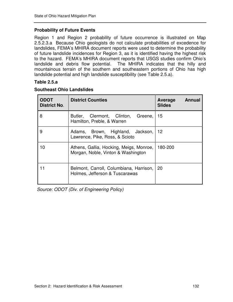
Probability of Future Events
Region 1 and Region 2 probability of future occurrence is illustrated on Map 2.5.2.3.a Because Ohio geologists do not calculate probabilities of excedence for landslides, FEMA’s MHIRA document reports were used to determine the probability of future landslide incidences for Region 3, as it is identified having the highest risk to the hazard. FEMA’s MHIRA document reports that USGS studies confirm Ohio’s landslide and debris flow potential. The MHIRA indicates that the hilly and mountainous terrain of the southern and southeastern portions of Ohio has high landslide potential and high landslide susceptibility (see Table 2.5.a).
Table 2.5.a
Southeast Ohio Landslides
ODOT District No.
District Counties Average Annual Slides
8 Butler, Clermont, Clinton, Greene, Hamilton, Preble, & Warren
15
9 Adams, Brown, Highland, Jackson, Lawrence, Pike, Ross, & Scioto
12
10 Athens, Gallia, Hocking, Meigs, Monroe, Morgan, Noble, Vinton & Washington
180-200
11 Belmont, Carroll, Columbiana, Harrison, Holmes, Jefferson & Tuscarawas
20
Source: ODOT (Div. of Engineering Policy)

State of Ohio Hazard Mitigation Plan
Section 2: Hazard Identification & Risk Assessment 133
3
1
2
2
Produced by URS and Ohio EMADisclaimer: The information presented on this map has been compiled through various sources, the Ohio EMA does not guarantee its accuracy.
Source: USGS
Map 2.5.2.3.a
State of Ohio Hazard Mitigation Plan
Section 2: Hazard Identification & Risk Assessment 134
Environmental Impacts
A landslide’s impact on the environment can be quite noticeable with the scarring of the earth’s surface and vegetative debris strewn about. The environmental impact is not limited to this. It affects the wildlife’s habitat that, depending upon the severity, may or may not return to normal over time. In addition to the loss of habitat, landslides have the force and potential to reroute, dam, or displace streams and creeks, altering their ecosystems. Landslides have the potential to have a large impact on the environment. They impact all utilities (gas, electric, petroleum pipe lines, storm sewers, sewage and septic systems, and water supplies) which in turn impact the environment. Air quality can be affected by lead and asbestos from damaged older structures. The smoke from fires caused by ruptured gas lines would also contribute to polluting the air. Water sources and surrounding landscape can become contaminated with not only hazardous materials, but also from debris and damage from waste water treatment facilities that could permit raw sewage to enter the environment.
2.5.3 VULNERABILITY ANALYSIS & LOSS ESTIMATION
Methodology
The potential loss estimates, which do not include lifelines, are based upon high-level assumptions derived from the landslide history in each county. First, the counties were placed in three categories of potential loss, based upon landslide risk. The data come from the USGS’s Costly Landslide Events in the United States. The highest risk level found anywhere in the county was applied to the whole county. For example, a county that is mostly low risk with a small mount of territory subject to high risk was designated as high risk. A county was designated as low risk only if the entire county was at a low risk for landslide. Next, since it’s not possible to determine which individual structures are likely to be lost, the average structure value in each county was used to determine potential losses.
Results
The potential losses in a high potential loss county equal the average structure value in the county times ten potentially lost structures. Medium potential losses equal the average structure value in the county times one potentially lost structure. Low potential losses equal the average structure value in the county times zero potentially lost structures, i.e., low landslide potential results in potential losses due to landslides. Table 2.5.b depicts estimated losses based on landslide incidence and susceptibility.
State of Ohio Hazard Mitigation Plan
Section 2: Hazard Identification & Risk Assessment 135
Allen $89,013 Medium $89,013 Ashland $99,167 Low $0 Adams $62,190 High $621,901
Auglaize $103,509 Medium $103,509 Ashtabula $94,785 Medium $94,785 Athens $73,953 High $739,530
Champaign $102,764 Low $0 Butler $118,808 High $1,188,077 Belmont $64,053 High $640,528
Clark $115,714 Low $0 Cuyahoga $173,721 High $1,737,211 Brow n $85,457 High $854,572
Clinton $105,185 Medium $105,185 Delaw are $178,692 Low $0 Carroll $88,152 Medium $88,152
Craw ford $84,341 Medium $84,341 Fairfield $118,382 Medium $118,382 Clermont $116,673 High $1,166,732
Darke $91,774 Medium $91,774 Franklin $129,404 Low $0 Columbiana $83,399 High $833,994
Defiance $88,758 Medium $88,758 Geauga $175,189 Medium $175,189 Coshocton $81,179 Medium $81,179
Erie $138,957 Medium $138,957 Greene $130,079 Low $0 Gallia $74,847 Medium $74,847
Fayette $89,871 Low $0 Hamilton $133,401 High $1,334,012 Guernsey $67,546 Medium $67,546
Fulton $112,365 Medium $112,365 Knox $93,432 Low $0 Harrison $59,105 High $591,048
Hancock $103,815 Low $0 Lake $153,500 Medium $153,500 Highland $84,108 Low $0
Hardin $74,821 Medium $74,821 Licking $111,871 Medium $111,871 Hocking $79,877 Medium $79,877
Henry $93,482 Medium $93,482 Lorain $133,971 Low $0 Holmes $105,362 Low $0
Huron $101,618 Low $0 Mahoning $89,778 Medium $89,778 Jackson $71,016 Medium $71,016
Logan $91,623 Low $0 Medina $148,346 Low $0 Jefferson $55,626 High $556,255
Lucas $109,511 High $1,095,106 Montgomery $106,758 Low $0 Law rence $66,516 High $665,162
Madison $117,374 Low $0 Pickaw ay $114,886 Low $0 Meigs $60,499 High $604,992
Marion $91,612 Low $0 Portage $129,091 Medium $129,091 Monroe $59,355 High $593,546
Mercer $92,577 Medium $92,577 Richland $92,275 Medium $92,275 Morgan $71,635 Medium $71,635
Miami $118,581 Low $0 Stark $99,745 Medium $99,745 Muskingum $82,973 Medium $82,973
Morrow $98,524 Low $0 Summit $130,413 High $1,304,129 Noble $65,029 High $650,286
Ottaw a $128,132 Medium $128,132 Trumbull $85,421 Medium $85,421 Perry $69,858 Medium $69,858
Paulding $71,783 Medium $71,783 Warren $143,151 High $1,431,505 Pike $83,147 Low $0
Preble $99,686 Low $0 Wayne $107,620 Low $0 Ross $80,576 Low $0
Putnam $96,294 Medium $96,294 TOTAL $3,091,886 $8,144,971 Scioto $67,115 Low $0
Sandusky $100,864 Medium $100,864 Tuscaraw as $93,030 Medium $93,030
Seneca $92,474 Low $0 Vinton $63,290 Medium $63,290
Shelby $105,897 Low $0 Washington $72,527 High $725,271
Union $121,528 Low $0 TOTAL $2,188,093 $10,087,220
Van Wert $81,137 Low $0
Williams $91,255 Medium $91,255
Wood $116,308 High $1,163,085
Wyandot $83,507 Low $0
TOTAL $3,404,654 $3,821,301
County
Estimate of Potential Losses to Landslide by Region
Potential
Loss
Estimated
Loss
Region 1
Average
Structure
Value
Estimated
Loss
Potential
Loss
TABLE 2.5.b
Source: USGS & HAZUS-MH
Region 2 Region 3
County
Average
Structure
Value
Potential
Loss
Estimated
LossCounty
Average
Structure
Value
State of Ohio Hazard Mitigation Plan
Section 2: Hazard Identification & Risk Assessment 136
Region 1 has a potential estimate loss to structures by landslide of $3,821,301. Within this region, Wood County has the highest potential for losses at a loss value of $1,163,085. Additionally, several counties within the region have no estimate potential loss.
Region 2 has the second highest estimate of potential loss at a value of $8,144,971. Cuyahoga County has the highest estimate within the region at a loss value of $1,737,211.
Region 3 has the highest risk and, in addition, has the highest vulnerability at a value of $10,087,220. Within this region Clermont County has the highest estimated loss at a loss value of $1,166,732.
These results do not account for everything affected by landslide, especially roads. Landslides and mudslides affecting roads lead to costly repairs by state and local governments. In the six to seven year period leading up to 2002, repair, rehabilitation, and maintenance costs exceed $34 million, at an average of $4.9 million per project. The massive floods of 1996-98 in eastern and southeastern Ohio counties averaged $4.16 million each in costs to the state.
VULNERABILITY ANALYSIS & LOSS ESTIMATE OF STATE OWNED CRITICAL FACILITIES
Methodology
The methodology to determine the vulnerability of state-owned structures and critical facilities to landslides were identified in section 3.1. However, in regards to the discussion as it focuses on landslides will be confined to the areas that have a high susceptibility and low incidence or higher (see Map 2.5.2.3.a).
Results
Though Lucas County has sparse areas of high susceptibility to landslide, at this time there have been no assessments completed on state structures in Region 1 (see Table 2.1.a and Appendix C).
Within Region 2 assessments have been conducted on 9 of the 25 counties (see Table 2.1.4.2.a and Appendix C). Butler County, Fairfield County, Hamilton County, and Warren County all have sparse areas of high susceptibility, but to date have not been assessed for vulnerability to state owned structures and critical facilities. Cuyahoga, Licking, and Summit counties all have a high susceptibility to landslide incidence. In total there are a total of 58 state-owned structures vulnerable to landslides at an estimated potential loss of $1,452,201,723. Out of those structures identified, 9 are classified as critical facilities with an estimate potential loss of $11,763,212.
Five of the 29 counties within Region 3 have been assessed for vulnerable state-owned structures and critical facilities (see Table 2.1.a and Appendix C). A significant portion of Region 3 has a high susceptibility to landslides. Columbiana,

State of Ohio Hazard Mitigation Plan
Section 2: Hazard Identification & Risk Assessment 137
Carroll, Harrison, Coshocton, Muskingum, Perry, Hocking, Morgan, Nobel, Monroe, Morgan, Washington, Hocking, Athens, Vinton, Jackson, Gallia, Lawrence, Clermont, Brown, and Adams Counties all have been identified with a high susceptibility to landslides (see Map 2.5.2.3.a) However, at this time state owned structures have not been identified for those specific counties. Belmont, Guernsey, Jefferson, and Tuscarawas counties also have a high susceptibility to landslide incidence. In total there are a total of 88 state-owned structures vulnerable to landslides at an estimated potential loss of $82,711,564. Out of those structures identified 10 are classified as critical facilities with an estimate potential loss of $5,707,080.