11.27.2009, REPORT, Mongolian Nature and Environment Legislative Scorecard, The Asia Foundation

Improving Transportation Without Putting Nature Second
Patricia A. White and Michelle Ernst
Second Nature

We gratefully acknowledge the support of the
Surdna Foundation and the
Doris Duke Charitable Foundation
in the production of this report.

EXECUTIVE SUMMARY ..............................V
INTRODUCTION .........................................1
IMPACTS....................................................3
Roadkill........................................................3
Habitat Loss .................................................5
Air/Soil Pollution.........................................6
Water Pollution ...........................................8
Noise Pollution............................................8
Invasive Species ...........................................9
Sprawl ........................................................10
INTEGRATED PLANNING ..........................14
State Biodiversity Planning .......................14
Florida’s Planning Process .........................15
Sonoran Desert Conservation Plan...........17
NatureServe and Heritage Programs .........18
The Nature Conservancy’s Ecoregional Plans ......................................18
Planning and TEA-21 ................................23
CONSERVATION BANKING .......................24
Colorado’s Shortgrass Prairie Initiative.....27
NCDOT’s Red Cockaded Woodpecker Habitat Bank .............................................28
California...................................................30
Conservation Banking and TEA-21...........32
INTERAGENCY COORDINATION ...............33
Oregon DOT’s Collaborative Environmentaland Transportation Agreement onStreamlining (CETAS) ................................33
California Tri-Agency Partnership Agreement .................................................36
Interagency Coordination and TEA-21 ................................................39
WILDLIFE CROSSINGS ..............................41
Florida........................................................41
A Spirit of Place .........................................43
Aquatics .....................................................43
Wildlife Crossings and TEA-21 .................46
PUBLIC LANDS.........................................47
Federal Lands Highway Program (FLHP) ........................................................47
Alternative Transportation........................50
Zion National Park ....................................50
Santa Ana National Wildlife Refuge Tram...........................................................51
Public Lands and TEA-21 ..........................53
NATIVE VEGETATION ...............................54
Costs of Invasives ......................................54
Iowa’s Living Roadway Program ...............57
Native Vegetation and TEA-21..................60
CONCLUSION ...........................................61
RECOMMENDATIONS ...............................62
APPENDIX................................................64
A. Other Statewide Conservation Plans (OR, MA, MD, NJ)................................64
B. Comprehensive Wildlife ConservationPlanning Guidance ..............................65
C. California’s Conservation Banking policy.....................................67
D. MOU — Oregon’s CETAS ....................69
TABLE OF CONTENTS

Transportation agencies have come a
long way toward addressing environ-
mental issues. In my 25 years with the
Florida Department of Transportation, I wit-
nessed a paradigm shift from reluctance to
acceptance and finally, active stewardship.
Research continues
to help transporta-
tion agencies better
understand the
environmental
impacts of trans-
portation networks.
The relationship of
transportation corri-
dors to land use is
becoming more evi-
dent. Now that we
have a better under-
standing of the
potential consequences of transportation activ-
ities, we examine them in greater detail
throughout the planning, design and construc-
tion process.
With better scientific understanding of the
impacts on the environment of transportation
and related development, there is an increasing
urgency to get the answers right when plan-
ning and developing transportation facilities.
This is a “quality of life” issue because the very
resources that support life, air, water and the
land are at risk. Not only is it a quality of life
issue for the human species, but also for all of
the other species with which we share this
planet.
For new transportation facilities, the respon-
sibility to avoid environmental impacts has
never been greater because of diminishing nat-
ural resources. For existing roadways, we can
use our newfound knowledge to not only
improve the facility, but also to improve the
environment. With the right information,
tools, policies and spirit, we have a chance to
build a “second” nature, where the first has
been adversely impacted. This will only hap-
pen if all of the interests involved in trans-
portation planning and development work
together toward this common goal.
Cooperation and education are essential for
better decision making. Second Nature:
Improving Transportation Without Putting Nature
Second is a collaborative effort between two
organizations; one transportation and one con-
servation. The authors have identified conflicts
and provided solutions that advance and even
improve both transportation and conservation.
Hopefully, this information will inspire readers
to develop a more environmentally sound
transportation system.
Gary Evink
Florida DOT Ecologist (retired)
SECOND NATURE: Improving Transportation Without Putting Nature Second
iv
FOREWORD

The United States is approaching a cross-
roads — unimpeded urbanization may
soon collide with the limits of our
country’s natural resources. The rate of this
urbanization surpasses population growth, and
threatens to overwhelm previous victories in
environmental protection. Biological diversity
— the rich variety of natural species that forms
our natural life support system — is in jeop-
ardy. The most significant threat to America’s
biodiversity is habitat loss, and one of the
greatest consumers of habitat is poorly
planned, sprawling development.
Over the next few decades, America can
avert this collision between growth and biodi-
versity. Because transportation infrastructure
necessarily precedes development, current
transportation planning will shape future urban
growth. State transportation agencies and plan-
ners can steer investment toward greater mobili-
ty for better communities and away from
impacting our remaining natural areas.
Some state and local agencies are virtual lab-
oratories for progress; going above and beyond
regulatory requirements and paving the way
for others to follow. Federal policy can either
help or hinder this leadership. Reauthorization
of the Transportation Equity Act for the 21st
Century (TEA-21) provides a great opportunity
for Congress to enable and encourage steward-
ship and innovation at the state and local levels.
Mobility does not have to come at the
expense of biodiversity. Second Nature:
Improving Transportation Without Putting Nature
Second profiles innovative programs that seek
to improve transportation infrastructure while
protecting biodiversity. Because this concept is
relatively new, many of the case studies are still
in the early stages. While outcomes are uncer-
tain, each of the programs exemplifies the cre-
ative cooperation necessary to affect change.
With support, these innovative practices can
become “second nature” to transportation and
resource professionals across the nation.
IMPACTS
Because both mobility and biodiversity are
national priorities, it is necessary to understand
how they interact. Until recently, our under-
standing of how nature degrades roads far out-
weighed our understanding of how roads
degrade nature. For example, road salt protects
drivers from ice, but damages waterways.
Similarly, fencing controls access to highways,
with little regard for the effect that such barri-
ers have on wildlife.
Road ecology, a new field of study, seeks to
explain the complex relationship between
roads and the natural environment. A road’s
environmental footprint extends far beyond
the edge of its pavement. In fact, nationwide
SECOND NATURE: Improving Transportation Without Putting Nature Second
v
EXECUTIVE SUMMARY

the “road-effect zone” is estimated to be 15 to
20 times as large as the actual paved right of
way.
Transportation infrastructure has significant
direct and indirect effects on the natural envi-
ronment. Roads directly affect wildlife habitat,
ecosystems, and water quality through land
consumption, roadkill, habitat fragmentation,
and replacement of natural cover with impervi-
ous surfaces and invasive species. Poorly
planned roads and highways open up vast
areas of wilderness and farmland to sprawling
residential and commercial development.
INTEGRATED PLANNING
State and federal agencies spend consider-
able time and capital both protecting natural
areas and building transportation infrastruc-
ture. Unfortunately, conservation and growth
efforts often happen independently and then
come into conflict during the permitting and
construction phases of a transportation project.
But, if conservation efforts are taken into
account at the earliest stages of transportation
planning, both priorities can be realized, in less
time and at less cost.
Florida’s Efficient Transportation Decision
Making Process (ETDM) overlays maps of
strategic habitats with transportation plans,
identifying potential environmental concerns
at the earliest stage of planning. In Arizona,
local officials are using the Sonoran Desert
Conservation Plan to “broaden the vocabulary
of the growth debate to include biological and
scientific concepts, and reframe the elements
of regional planning to encompass the relation
that the land has to natural and cultural
resources.” Across the U.S., states are develop-
ing comprehensive wildlife conservation plans
under the Department of Interior’s State
Wildlife Grants Program. In addition, Heritage
Programs and The Nature Conservancy identify
and map areas that need to be protected to
ensure the survival of each ecoregion’s biologi-
cal diversity.
CONSERVATION BANKING
Transportation projects are required to com-
pensate for adverse environmental impacts in a
process known as mitigation. Traditional com-
pensatory mitigation is conducted on-site, on a
project-by-project basis. Because such small-
scale mitigation is expensive and rarely ecologi-
cally sound, mitigation banking is often used
SECOND NATURE: Improving Transportation Without Putting Nature Second
vi
PATR
ICIA
WH
ITE,
DEF
END
ERS
OF
WIL
DLI
FE

to compensate for wetland loss. Large, contigu-
ous wetlands are created or restored to earn
advance mitigation credits for future impacts
elsewhere.
Although wetland mitigation banking has
been heavily criticized, the practice is now
being applied to other ecosystems. Much like
wetland banking, conservation banking proac-
tively preserves large tracts of habitat to offset
the adverse impacts of future development
projects. For a variety of reasons, banking may
be a more appropriate tool for non-wetland
habitat conservation. Through a combination
of comprehensive large-scale planning and a
coordinated mitigation strategy, states and
communities can reduce the conflict between
development and conservation aims.
In a handful of states, transportation agen-
cies are developing conservation banks to more
effectively mitigate impacts, while also control-
ling costs and improving project delivery.
Colorado Department of Transportation is pro-
tecting shortgrass prairie and North Carolina
DOT has banked habitat for the endangered
red-cockaded woodpecker. And in California,
where some state laws are stricter than federal,
conservation banking is widely used to com-
pensate for the impacts of road projects.
INTERAGENCY COORDINATION
Lack of coordination among federal, state
and local agencies can delay transportation
projects and cause unnecessary loss of wildlife
habitat. Early involvement allows natural
resource agencies to identify potential conflicts
and helps planners develop projects with mini-
mal environmental impact.
In response to guidelines set forth in TEA-
21, several state transportation agencies initiat-
ed formal or informal partnerships with
resource agencies. Oregon’s Collaborative
Environmental and Transportation Agreement
for Streamlining (CETAS) program establishes a
working relationship between ODOT and ten
state and federal transportation, natural
resource, cultural resource, and land-use plan-
ning agencies. California’s Tri-Agency
Partnership Agreement was born out of the
recognition that transportation projects, espe-
cially those that promote environmental objec-
tives, need to be delivered in a timely fashion,
and that improved collaboration among the
three agencies is central to achieving that goal.
WILDLIFE CROSSINGS
Because roads are such prominent — and
permanent — parts of the landscape, expanded
methods are needed to reduce their effects on
surrounding ecosystems and make them more
permeable for wildlife on the move. Solutions
range from reducing speed limits and adding
cautionary signage to building passages.
Wildlife crossings are not a panacea, but they
can go a long way toward reconnecting frag-
mented habitat.
Several European countries and Canada
have built wildlife passages to reestablish habi-
tat connectivity across existing roadways. In
SECOND NATURE: Improving Transportation Without Putting Nature Second
vii

the U.S., Florida is leading the way with
wildlife passages throughout the state for
species such as the endangered Florida panther
and the Florida black bear. Currently, Montana
DOT is incorporating 42 wildlife passages, from
small fish culverts to an open-span overpass, in
the reconstruction of US 93.
PUBLIC LANDS
Federal lands, including national parks,
forests, wildlife refuges and monuments consti-
tute one quarter of the United States and pro-
vide habitat for nearly two-thirds of all threat-
ened or endangered species. Publicly owned
lands are critical for biodiversity conservation,
but also support local economies through trav-
el and tourism.
Federal Lands Highway Program (FLHP)
maintains 90,000 miles of roads on public
lands. Because FLHP has been largely devoted
to building roads instead of providing access
and mobility, vehicle overcrowding, traffic and
air pollution continue to degrade the visitor
experience and drive away wildlife.
To maintain both mobility and biodiversity,
roads on public lands must be maintained in a
manner consistent with surrounding resources
and visitors must be given environmentally
sensible transportation options. Some national
parks now provide visitor friendly and environ-
mentally sensible transportation options such
as shuttle buses, ferries and bicycle and pedes-
trian trails. The Santa Ana National Wildlife
Refuge in Texas utilizes a public-private partner-
ship to provide wildlife-friendly transportation
in the refuge and revenue to the local economy.
NATIVE VEGETATION
After loss of habitat, invasive species repre-
sent the greatest cause of species endangerment
and decline in the U.S. Invasive species are
responsible for at least $137 billion a year in
economic losses. Nearly 50 percent of species
on the endangered or threatened species lists
are at risk because of non-native species.
Because they disturb natural habitats, trans-
portation systems facilitate the spread of plant
and animal species outside their natural range.
With 12 million acres of land contained within
public rights-of-way, transportation agencies
are also land managers on a grand scale. Too
often, the objective of roadside vegetation
management has been to establish an inexpen-
sive, attractive and fast-growing slope stabilizer.
Where native flora was too costly, grew too
SECOND NATURE: Improving Transportation Without Putting Nature Second
viii
PATR
ICIA
WH
ITE,
DEF
END
ERS
OF
WIL
DLI
FE

slowly, or was deemed unattractive, non-native
species were often planted.
Given the widespread threat of invasive
species, resource managers and transportation
agencies have a responsibility to first stop
adding to the problem. Second, they must
attempt to repair the damage that has already
been done. Finally, where possible, roadsides
should be enhanced to restore the ecological
value they once had. Public rights-of-way must
be managed as a valuable resource with the
most positive impact on the environment and
the economy.
Many states have made great strides in
native roadside vegetation management.
Through Iowa’s Living Roadway Program, road-
side vegetation is maintained so that roadways
are safe, visually interesting, ecologically inte-
grated and useful for many purposes.
RECOMMENDATIONS
1. Integrate conservation planning into trans-
portation planning.
2. Use conservation banking in concert with
large-scale conservation plans to mitigate
unavoidable impacts of transportation.
3. Coordinate with resource agencies early, sub-
stantively and continuously throughout trans-
portation planning and project development.
4. Build wildlife crossings where necessary to
repair ecological damage and restore habitat
connectivity.
5. Provide alternative transportation and main-
tain roads on public lands in a manner con-
sistent with surrounding natural resources.
6. Use only native species in roadside vegeta-
tion management.
SECOND NATURE: Improving Transportation Without Putting Nature Second
ix


The U.S. is outgrowing the American
dream. Between 1950 and 1990, urban
land area increased more than twice as
fast as population. Development sprawls into
rural and natural areas, consuming over two
million acres of farmland, open space and
wildlife habitat per year. While largely influ-
enced by demographic and socio-economic fac-
tors, public policies on transportation and land
use have played an important role in shaping
development patterns. If the rate of develop-
ment continues at its current pace and follows
today’s sprawling model, the amount of land
developed in the next 25 years will equal the
total amount developed since the country’s
founding.1
As of January 2003, more than 1,300 species
of plants and animals had been listed as threat-
ened or endangered by the federal govern-
ment. The continued existence of many of
these species, and of many others that are
not on the list, will depend on the avail-
ability of quality habitat. Unfortunately,
that habitat is being rapidly lost to sprawl-
ing development largely ushered in by
transportation policies that are focused on
building roads without sufficient efforts to
minimize environmental impacts. Even
species not threatened by the loss of habitat
may be vulnerable to another ill brought
on by transportation projects — the intro-
duction of foreign species, which can harm
native species through displacement or preda-
tion. Together, the loss, degradation or frag-
mentation of habitat and the spread of inva-
sive species are the greatest threats to biodiver-
sity.2 These dual forces are responsible for what
conservation biologists now predict will be the
“sixth great extinction” — the loss of a third of
the world’s plant and animal species within the
next 50 years.3
Road and highway construction is one of
the chief culprits responsible for the loss of bio-
diversity. Roads harm the natural environment
in many ways: they pollute streams and wet-
lands, they cause roadkill, and they promote
land development that consumes natural habi-
tat. The emergence of a new field of study, road
ecology, underscores the importance of trans-
SECOND NATURE: Improving Transportation Without Putting Nature Second
1
1INTRODUCTIONINTRODUCTION
0%
10%
20%
30%
40%
50%
60%
70%
80%
90%
100%
1982-1987 1987-1992 1992-1997 1997-2025*
Time Period
Gro
wth
Rat
e
PopulationDeveloped Land
*U.S. Census Bureau projections and extrapolation of Natural Resource Inventory data based on current growth rates for developed land

portation’s impact on biodiversity. Road ecolo-
gy “uses the science of ecology and landscape
ecology to explore, understand, and address
the interactions of roads and vehicles with
their surrounding environment.”4
Transportation agencies have long-recog-
nized the impact that their projects have on
biodiversity. Since the early 1970’s agencies
have been assessing the environmental impacts
of federally-funded projects through
Environmental Impact Statements required
under the National Environmental Policy Act
(NEPA). But recently, some agencies have
sought better approaches to addressing envi-
ronmental impacts and thereby improving
transportation project delivery.
This report showcases innovative programs
and partnerships pioneered by state and local
agencies across the nation to more effectively
coordinate transportation, land use, and
resource planning and investments. These case
studies demonstrate how transportation agen-
cies can both improve project delivery and bet-
ter protect environmental and cultural
resources. These goals can be achieved by plan-
ning early in the process for biodiversity con-
servation, by integrating environmental knowl-
edge into transportation plans, and through
better coordination among agencies. This
report will examine some innovative programs
that already incorporate these ideas, and that
may serve as models for the rest of the nation.
But first, it will examine how roads and high-
ways and the development they facilitate
threaten the country’s natural heritage.
SECOND NATURE: Improving Transportation Without Putting Nature Second
2
1. National Resources Inventory. Natural ResourcesConservation Service. U.S. Department of Agriculture,Washington, DC. 2001.
2. G. Ohland and H. Dittmar. Biodiversity and SmartGrowth: Sprawl Threatens Our Natural Heritage. Funders’Network for Smart Growth and Livable Communities.Translation Paper Number 10, October 2002.
3. Center for Biodiversity and Conservation, AmericanMuseum of Natural History. Humans and OtherCatastrophes: Perspectives on Extinction. A summary ofthe April 1997 symposium of the same name.
4. Richard T. T. Forman, Daniel Sperling, et al. RoadEcology: Science and Solutions. (Washington, DC: IslandPress, 2003) xiv.
CO
ALI
TIO
N F
OR
SON
ORA
N D
ESER
T PR
OTE
CTI
ON
After more than 100 years of road and
highway building, the United States is
now criss-crossed by nearly four mil-
lion miles of roadways.1 That translates to
nearly 19,000 square miles of asphalt, an area
greater than the states of New Hampshire and
Vermont combined, greater even than the
country of Switzerland.2 Add in all the parking
lots, private roads, driveways and road shoul-
ders, and the total amount of paved land
comes to approximately one percent of the
total area of the contiguous United States.3
The construction of roads and highways
opens up vast areas of wilderness and farmland
to residential and commercial development.
The sprawl that occurred after World War II
continues to spread, particularly in the South
and West. Data from the U.S. Census shows
that from 1990 to 2000, the population of cen-
tral cities within metropolitan areas grew by
eight percent. But during that same period, the
population of the suburbs and exurbs (the
most far-flung suburban developments) of
those areas skyrocketed by nearly 18 percent.4
Roads and highways and the development
they foster have severe impacts on habitat,
wildlife and plants. These include roadkill;
habitat loss, degradation and fragmentation;
air, water, soil, and noise pollution; and inva-
sive species. As noted in the recently published
book by Richard Forman, Daniel Sperling and
other notable authors, Road Ecology: Science and
Solutions, “The end result of a highly connected
road system is a decrease in both the number
and the abundance of the species that once
inhabited the landscape.”5
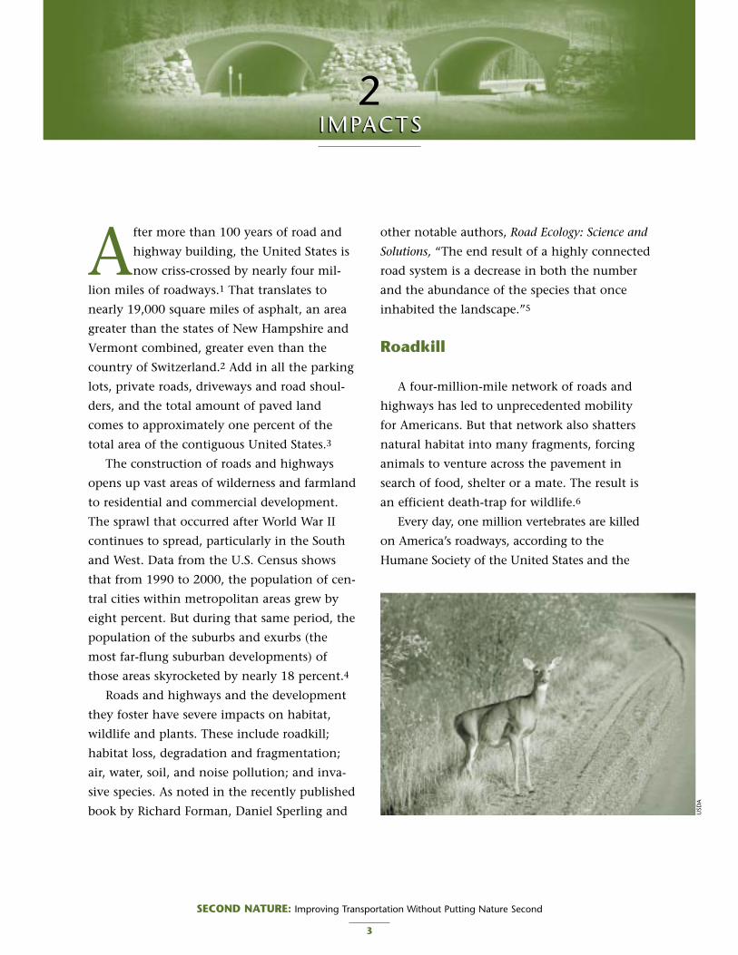
Roadkill
A four-million-mile network of roads and
highways has led to unprecedented mobility
for Americans. But that network also shatters
natural habitat into many fragments, forcing
animals to venture across the pavement in
search of food, shelter or a mate. The result is
an efficient death-trap for wildlife.6
Every day, one million vertebrates are killed
on America’s roadways, according to the
Humane Society of the United States and the
SECOND NATURE: Improving Transportation Without Putting Nature Second
3
2IMPACTSIMPACTS
USD
A
Urban Wildlife Research Center.7 This is an
astonishing figure, but less so perhaps when one
considers the sheer numbers of dead deer, squir-
rels, raccoons, and opossum passed by on the
daily commute. Indeed, Americans kill more
wildlife through collisions with vehicles than in
any other way. In some locations, for particular
species, the roadkill rate may exceed natural
causes of death due to disease and predation.8
For some species, collisions with vehicles
threaten their very existence. The state of
Florida, which is largely characterized by low-
density, auto-oriented development, has
become well-known for conflicts between
wildlife and vehicles. In that state, the remain-
ing populations of endangered or threatened
species and subspecies such as the Florida black
bear, the Key deer, and the Florida panther, are
seriously jeopardized by collisions with vehi-
cles. Roadkills of the Florida black bear have
grown 29-fold, from just two or three during
the 1970s to 90 in 1998. Roadkill is the leading
known cause of death for the endangered Key
deer. From 1970 to 1992, more than 1,000 Key
SECOND NATURE: Improving Transportation Without Putting Nature Second
4
Consider taking a leisurely stroll or nature walk in the edge of
woods by a busy two-lane highway. The sense of leisure quickly
evaporates in the face of traffic noise. Speeding vehicles evoke a
sense of danger. You may be confronted underfoot with society’s
refuse. Busy roads and a bucolic outdoors seem incompatible.
So you move back into the wooded edge to look more
closely. Many of the native forest birds seem to be missing –
even for quite a distance into the forest; apparently it is too
noisy. Indeed, few other forest vertebrates – mammals, frogs,
turtles, snakes – are seen; it must be a road-avoidance zone for
them, too. If you had ventured to walk along the roadside, you
might have seen road-killed animals, though carcasses disap-
pear quickly where road-kill scavengers hunt. The combination
of road-avoidance zone and road-kill strip makes you realize
what a barrier the busy highway is, dividing large natural popu-
lations into small ones that may be prone to local extinction.
Also, wildlife movement corridors that connect distant patches
across the landscape may be severed. You wonder whether this
is an inadvertent collective assault on biodiversity.
Unlike the adjoining forest interior, the forest edge seems
to be full of generalist "weedy" plants, some of them non-
native exotics, all persisting next to the open environment of a
frequently mowed roadside. The roadside vegetation growing
on earth that was homogenized and smoothed during road
construction seems monotonous, largely devoid of its natural
heterogeneity and richness. A few grasses, plus some non-
native plants, tend to dominate at the expense of a diversity of
native wildflowers. Open straight roadside ditches carry
warmed water, alternating with pulses of rainwater, into a nar-
row, wooded stream that lost its valuable curves during road
construction. A specific set of invisible chemicals has reached
the roadside and perhaps the forest – nitrogen oxides, hydro-
carbons, herbicides, roadsalt, and heavy metals such as zinc
and cadmiums are typical. Entering the streams, wetlands, and
groundwater around you, they inhabit all kinds of natural
processes and are toxic to some of the species.
What is it like next to a busy road? No place for a neigh-
borhood walk. Or a path in a park. Or even a nature reserve.
Here nature is both severed and impoverished. Road ecology is
needed.
W H A T ’ S N A T U R E L I K E N E A R A B U S Y H I G H W A Y ?
Republished from Richard T. T. Forman, Daniel Sperling, et al. Road Ecology: Science and Solutions. (Washington, DC: Island Press, 2003) 4.

deer were killed in collisions with vehicles,
averaging 45 killed per year; since 1992 the
number of individuals killed by cars each year
has remained well above 30. The endangered
Florida panther is also threatened by conflicts
with vehicles. Only about 80 Florida panthers
remain in the wild today, and as many as seven
are killed each year by cars. In the spring of
2001, seven panthers were killed in just three
months, breaking the previous record. Scientists
fear that the population will be unable to sus-
tain itself, given this mortality rate.9
Other threatened and endangered species
throughout the rest of the country that are par-
ticularly at risk because of wildlife-vehicle colli-
sions include the ocelot, the Canada lynx, the
grizzly bear, desert tortoise, the San Joaquin kit
fox, and the Houston toad.10
People are also victims. Collisions between
larger wildlife species and vehicles often result
in vehicle damage and injury or death to their
human occupants. A study of accidents in
Vermont between 1981 and 1991 found prop-
erty damage in 94 percent of collisions
between vehicles and deer. Nationwide, in
2001 vehicle-wildlife collisions were responsi-
ble for an estimated 29,000 human injuries and
177 human fatalities.11
Habitat Loss
Habitat loss is the most significant threat to
endangered species, 85 percent of which are
imperiled in this way.12 A 1976 study by the
Council on Environmental Quality reported that
up to 48 acres of habitat is lost with the con-
struction of one mile of Interstate highway.13
For many species, the very presence of a
roadway can represent an impassable barrier,
either psychologically or physically. For these
species, roadways fragment existing habitat
and isolate populations into smaller groups.
This can be devastating to wide-ranging ani-
mals that need large areas of contiguous habi-
tat to survive. Young animals may be so con-
fined by habitat fragmentation that they are
unable to establish their own territories. A host
of related issues can arise, including genetic
problems from inbreeding, which can result in
weak or sterile offspring.14 Research in
Germany on how road barriers affected small
local populations of the common frog found
significant alterations in their genetic structure,
including lower genetic variability among indi-
viduals.15 Animal populations that are isolated
are also more vulnerable to natural catastro-
phes such as flooding or drought because they
are unable to move to other areas. Habitat frag-
mentation may also make it impossible for
species to adapt to climate change, making
SECOND NATURE: Improving Transportation Without Putting Nature Second
5
Habitat loss is the most significant threat to
endangered species, 85 percent of which are
imperiled in this way. Up to 48 acres of
habitat is lost with the construction of one
mile of Interstate highway.

extinction much more likely.16
Even large, adult animals such as bobcats,
wolves, and grizzly bears, have been found to
avoid roads, so that while the roads may not
present a physical barrier to movement, they still
restrict movement and therefore fragment habi-
tat.17 Elk in western Montana have been found
to avoid areas within one-quarter to one-half
mile of roads, depending on the type of road and
the amount of traffic it supports. A study of griz-
zly bears in British Columbia found that the
bears would avoid areas within one-half mile of
roads. Experts in the ecological impacts of roads
have stated that the “impact of road avoidance
must well exceed the impact of either roadkills
or [direct] habitat loss in road corridors.”18
The effect of habitat fragmentation is devas-
tating to populations of
wide-ranging animals. In
addition to direct loss and
fragmentation, much addi-
tional habitat is degraded
by such factors as noise, air
and water pollution, and by
the creation of new micro-
climates that border road-
ways. Such microclimates
often have more sunshine
and wind, lower humidity
and different patterns of
rainfall, snowfall and
snowmelt than adjacent
areas.19 These edge habitats
are often unsuitable for
native species, but attractive
to invasive, non-native species.20
Though the extent of habitat degradation
varies depending on the type of roadway and
its subsequent use, the effect can be felt as
much as 3,000 feet beyond the edge of the
pavement. Scientists estimate that this road-
effect zone currently impacts as much as 15 to
20 percent of the land surface of the U.S.21
These individual factors are discussed below.
Pollution
Roads, highways, and the development they
facilitate cause air, soil, water and noise pollu-
tion. One study of 23 important pollutants
found along roads determined that 83 percent
came from vehicles.22 Driving is one of the
SECOND NATURE: Improving Transportation Without Putting Nature Second
6
The road-effect zone *

largest contributors to air pollution — motor
vehicles are responsible for more than two-
thirds of the carbon monoxide in the atmos-
phere, a third of the nitrogen oxides (which
react to form ozone or smog and also form acid
rain), and a quarter of the hydrocarbons
(which also contribute to ozone).
Almost every plant type — conifers, broad-
leafed trees, shrubs, herbs, and grasses —
includes one or more species that are especially
susceptible to ozone. For all types of vegeta-
tion, ozone interferes to some extent with the
production and storage of starches, reducing
growth rates and weakening plants. This makes
plants more vulnerable to disease, insect
attacks, and other environmental stresses.23
Cars and trucks also emit pollutants that
form acid rain. Acid rain is a serious problem
for aquatic ecosystems and has wide-ranging
effects on the many species that depend on
them, including insects, amphibians, fish,
birds, and mammals. Spikes in acidity caused
by spring snowmelt in New England have
killed brook and rainbow trout, as well as
Atlantic salmon. Amphibians are particularly
susceptible to acid rain, which reduces their
reproductive success. While acidification does
not typically harm mammals and birds directly,
it may harm them indirectly by reducing their
food supply. In fact, acid rain has been linked
to declines in songbirds such as the wood
thrush because it reduces the supply of the cal-
cium-rich foods the birds depend on.24
Motor vehicles also emit a variety of heavy
metals: motor oil and tires contain zinc and cad-
mium; gasoline contains nickel; and diesel fuel
contains lead. These heavy metals have been
found in greater concentrations closer to roads
and in areas with higher traffic volumes.
Research on earthworms has found concentra-
tions of heavy metal high enough to kill earth-
worm-eating animals.25 A study of little brown
bats, short-tailed shrews, and meadow voles
along the Baltimore-Washington Parkway found
lead at or above levels known to cause death or
reproductive impairment in domestic animals.26
Chemicals used in the maintenance of road-
ways also contaminate roadside ecosystems.
While many state departments of transportation
have begun to reduce the use of herbicides and
other chemicals, the use of herbicides continues
to damage roadside ecosystems.27 Those chemi-
cals may promote the invasion of weedy and
exotic species, which are resistant to herbicides.
Even more worrisome, herbicides can be trans-
ported from treated roadsides into aquatic envi-
ronments. If large amounts of these herbicides
find their way into lakes or streams, biological
communities could be seriously jeopardized.28
According to the U.S. Environmental
Protection Agency, approximately 10 million
tons of rock salt were used on the nation’s
roads between the mid-1980s and the mid-
1990s. That usage was found to have caused at
SECOND NATURE: Improving Transportation Without Putting Nature Second
7
A one-acre parking lot produces about 16
times as much runoff as a one-acre meadow.

least 11 percent of the impaired stream miles
reported nationally.29 The most commonly
used road salt is known to contaminate drink-
ing water supplies, and to be toxic to many
species of plants, fish, and other aquatic organ-
isms.30 Road salt used in the Rochester, New
York area caused a ten-fold increase in the
chloride concentration in Irondequoit Bay of
Lake Ontario.31 Finally, wildlife may be attract-
ed to road salt as an easily accessible salt lick
and may then end up as roadkill.32
Water Pollution
Roads, highways and parking lots are what
hydrologists call impervious surfaces. Those
impervious surfaces cause runoff to flow more
quickly into open bodies of water, rather than
allowing it to seep naturally into the ground to
recharge aquifers. A one-acre parking lot pro-
duces about 16 times as much runoff as a one-
acre meadow. Numerous studies have found
that when impervious surfaces cover more
than ten percent of a watershed, the rivers,
creeks, and estuaries they surround become
biologically degraded.33
Runoff flowing into streams, rivers, or
creeks leads to erosion and sedimentation,
thereby degrading aquatic habitat. As runoff
flows over pavement, its temperature rises.
Because warmer water has less dissolved oxy-
gen, it can make the affected body of water
unsuitable for certain plants, invertebrates, and
fish.34
Runoff also carries with it numerous pollu-
tants, including sediment, nutrients, trace met-
als, pesticides and petroleum hydrocarbons.
The addition of nutrients can lead to algal
blooms, which can diminish clarity and, when
the algae decays, reduce dissolved oxygen lev-
els below the threshold requirement of some
fish and invertebrates. In many aquatic envi-
ronments, excess nitrogen leads to algal
growth. Nitrogen comes from many sources.
But as much as 25 percent of the additional
nitrogen that finds its way into coastal estuar-
ies comes from atmospheric deposition, much
of which originates from motor vehicles. (Cars
and trucks are responsible for one-third of
atmospheric nitrogen oxides.)35
Trace, or heavy metals from cars and trucks
may also poison aquatic environments.36 One
study of heavy metals found that even though
parking lots and major streets covered just six
percent of the watershed, they contributed a
quarter of the metals, and 64 percent of the
petroleum hydrocarbons in the watershed.37
Noise Pollution
Noise pollution from roads and highways,
initially during construction and later from
heavy traffic, can degrade wildlife habitat and
impair biodiversity. Most frequently, noise pol-
lution leads wildlife to avoid roads, but it has
also been shown to change reproductive behav-
ior and other patterns of activity. Often, noise
pollution causes an increase in the heart rate
and in the production of stress hormones in
animals. Birds and other wildlife that commu-
SECOND NATURE: Improving Transportation Without Putting Nature Second
8

nicate by auditory signals are especially vulner-
able to noise pollution. Territory establishment
and defense may also be disrupted by noise
from roadways.38 Research on toads and tree
frogs found that highway noise resulted in
abnormal reproductive behavior in the vicinity
of major roads.39 The presence of songbirds has
been shown to decline even at low noise levels,
and sharply drops near roads.40
Invasive Species
Non-native or invasive species pose a signif-
icant threat to our nation’s biological diversity,
and are causing substantial economic burdens.
Each year, approximately $137 billion nation-
wide is lost to the effects of invasive plants on
agriculture, industry, recreation, and the envi-
ronment. An estimated 4,600 acres of land are
invaded daily by invasive plants.41 Invasive
species impact nearly half the species currently
listed as threatened or endangered under the
federal Endangered Species Act.42
Roads and highways can encourage the
entry of invasive species in four ways: 1) road
medians and corridors have often been planted
with exotic plant species; 2) techniques used to
maintain roadways may encourage the growth
of invasive or exotic plant species; 3) roads
may facilitate the spread of invasive plant and
animal species; and 4) degradation of habitat
caused by roadways may usher in exotic and
invasive plants and animals.
Many state and local departments of trans-
portation have landscaped roadsides with non-
native plant species. Invasive woody plant
species, in particular, have been planted along
some roadsides to reduce erosion, control snow
accumulation, reduce headlight glare, or
enhance aesthetics.43 Unfortunately, the plant-
ing of invasives may have unexpected negative
consequences for wildlife habitat. Research of
Massachusetts roadsides found that in half of
the locations where non-native woody species
were planted, the species had spread into the
adjacent woods.44 It was not until the 1987
Surface Transportation and Uniform Relocation
Assistance Act (SUTRAA) that the federal gov-
ernment require states to plant native wild-
flower seeds or seedlings as part of landscaping
projects undertaken on highway projects that
receive federal assistance.45
Road or highway maintenance may also
encourage the spread of invasive species.
Roadside mowing tends to reduce the richness
of plant species and favor exotic plants.46
Mowers and other maintenance equipment
that is not thoroughly washed may also inad-
vertently spread invasive species by carrying
seeds from one site to another.47 Fertilization
or soil transfer in roadside management is also
known to alter roadside vegetation significant-
ly, typically in favor of invasive species.48
Invasive species may take advantage of roads
and highways to spread to other areas. Research
in New York State found that purple loosestrife, a
common invasive species that crowds out native
wetland vegetation, was able to spread via road-
side ditches, culverts connecting opposite sides
of a highway, and median strip vegetation.49
SECOND NATURE: Improving Transportation Without Putting Nature Second
9
Finally, habitat degradation caused by road-
way construction and on-going use may create
favorable environments for invasive species.
Indeed, many plant species thrive along road-
sides, but most of these are weedy. Examples
include rabbit brush in the Great Basin and cre-
osote bush in the Mojave Desert. These species
take advantage of increased light along cleared
roadsides and runoff water channeled to road
shoulders.50 Invasive animals are also known to
exploit degraded habitat. Perhaps the best
known is the brown-headed cowbird, which has
spread from the Great Basin to most of North
America largely because of forest fragmentation.
The cowbird, a brood parasite, lays its eggs in
the nests of other bird species, thereby forcing
the host birds to adopt the baby cowbirds, usu-
ally resulting in the death of their own off-
spring. Native forest birds show serious declines
in areas where cowbirds have invaded.51
Sprawl
Roads and highways indirectly impact
wildlife by facilitating residential and commer-
cial development. While transportation plan-
ners may shy away from taking responsibility
for land development, there can be no doubt
that in many cases new roadways have ushered
in building booms along their corridors. A
recent study of sprawl in Maryland found that
93 percent of developed properties within five
miles of a major Interstate highway (I-270)
were built after the adjacent section of the
highway was built; further, the study found
that highway corridors were much more devel-
oped than more distant areas.52
Highway-related development tends to be
auto-oriented and low-density. This type of
development is particularly destructive to habi-
tat because its footprint tends to be large and
because it precipitates further road develop-
ment. Recent data provides evidence of this
trend: from 1992 to 1997, the rate of develop-
ment doubled compared to the previous ten
years.53 If the rate of development continues at
that pace, the amount of land developed in the
next 25 years will equal the total amount
developed since the country’s founding.54
In the 45 years since President Dwight D.
Eisenhower created the Interstate highway sys-
tem, the number of miles driven by every man,
woman and child, has grown two and a half
times to nearly 10,000 miles per year.55 While
it may seem intuitive, recent research supports
the claim that sprawling development leads to
SECOND NATURE: Improving Transportation Without Putting Nature Second
10
CLA
IRE
DO
BERT
, USF
WS

increased driving. In one of the most compre-
hensive analyses of sprawl to date published by
Smart Growth America, researchers found an
indisputable relationship between sprawl and
driving. The study found that for every one
standard deviation decline in the Sprawl Index,
there is a 2-mile increase in miles driven per
person. In other words, the more sprawling a
metro area is, the more driving there is. The
results are even more compelling at the
extremes of the scale. In the 10 most sprawling
metro areas, residents drove an average of 27
miles per day. This compares to 21 miles per
day in the 10 least sprawling metro areas.56
Because sprawl requires people to drive
more to meet daily needs, such development
results in increased emissions of pollutants that
can degrade air and water quality and threaten
biodiversity.57 Further, sprawling development
may kick off a vicious cycle of more driving
leading to more traffic congestion, leading to
pressure for more roads, leading to road con-
struction, leading to more development. In the
end, farmlands, forests, grasslands, and all
other open space are paved over to make way
for more roads.
SECOND NATURE: Improving Transportation Without Putting Nature Second
11
Sprawling development is one of the most serious threats to wildlife and biodiversity because it results in fragmen-
tation, degradation and loss of natural habitat across the country. Smart growth is well-planned development that
protects open space and farmland, revitalizes communities, keeps housing affordable and provides more transporta-
tion choices. Combined with smart conservation, smart growth can provide for both more development and more
habitat protection by charting out where growth should and should not occur. The following are five transportation
solutions to ameliorating sprawl’s impacts on nature:
1. Integrate transportation planning and land use planning. Citizens, land use planners, natural resource managers
and transportation agencies should work together toward common goals
2. Ensure that transportation planning is compatible with water quality goals. Sprawling growth and the associated
increase in impervious surfaces contribute to rapid stormwater runoff and drought.
3. Encourage mass transit. Providing Americans with additional transportation options will reduce the need for addi-
tional roads, hence protecting more habitat for wildlife.
4. Encourage transit-oriented development. By concentrating development around public transit stations and stops,
communities can support economic development, offer residents more convenient places to live, and keep devel-
opment out of wildlife habitat.
5. Preserve roadway capacity by preserving open space. New and expanded roads often get immediately clogged
with traffic because commercial and residential development along the roads creates local traffic. Limiting road
access and using transportation funds for open space conservation adjacent to highways preserves the intended
mobility and scenic views.
Don Chen, Executive Director
Smart Growth America
PRESERVING NATURE THROUGH A SMART GROWTH APPROACH TO TRANSPORTATION

1. Federal Highway Administration. Highway StatisticsSeries 2001. Table HM-10. November 2002.
2. Derived by multiplying the 8,251,847 lane-miles of road-way (from FHWA. Highway Statistics Series 2001. TableHM-60. November 2002.) by 12 feet, the average lanewidth.
3. E.O. Wilson. Introduction to R. Forman, Land Mosaics:The Ecology of Landscapes and Regions. CambridgeUniversity Press: 1995.
4. STPP Analysis of 1990 and 2000 Decennial Census figures.
5. Richard T. T. Forman, Daniel Sperling, et al. RoadEcology: Science and Solutions. (Washington, DC: IslandPress, 2003) 137.
6. R. Noss. “The Ecological Effects of Roads, or The Road toDestruction.”
7. R. Noss. “The Ecological Effects of Roads, or The Road toDestruction.”
8. Richard T. T. Forman, Daniel Sperling, et al. RoadEcology: Science and Solutions. (Washington, DC: IslandPress, 2003) 115.
9. Defenders of Wildlife. Habitat and Highways Campaign<http://defenders.org/habitat/highways>
10. Defenders of Wildlife. Habitat and Highways Campaign<http://defenders.org/habitat/highways>
11. Richard T. T. Forman, Daniel Sperling, et al. RoadEcology: Science and Solutions. (Washington, DC:Island Press, 2003) 116-117. STPP Analysis of NationalHighway Traffic Safety Administration’s FatalityAnalysis Reporting System (FARS) database, 2001.
12. M.L. Shaffer, B.A. Stein. Precious Heritage: The Status ofBiodiversity in the United States. (Oxford UniversityPress, New York, 2000)
13. As reported in R. Noss. “The Ecological Effects of Roads,or The Road to Destruction.”
14. R.T.T. Forman and L.E. Alexander. “Roads and TheirMajor Ecological Effects,” Annu. Rev. Ecol. Syst. 1998.29:207-31.
15. R. Noss. “The Ecological Effects of Roads, or The Roadto Destruction.”
16. G. L. Evink. Interaction Between Roadways andWildlife Ecology: A Synthesis of Highway Practice.NCHRP Synthesis 305. Transportation Research Board— The National Academies: Washington, DC. 2002.
17. R. Noss. “The Ecological Effects of Roads, or The Roadto Destruction.”
18. R. Noss. “The Ecological Effects of Roads, or The Roadto Destruction.”
19. G. L. Evink. Interaction Between Roadways andWildlife Ecology: A Synthesis of Highway Practice.NCHRP Synthesis 305. Transportation Research Board— The National Academies: Washington, DC. 2002.
20. R.T.T. Forman and R.D. Deblinger. “The EcologicalRoad-Effect Zone for Transportation Planning andMassachusetts Highway Example,” Proceedings of theInternational Conference on Wildlife Ecology andTransportation. FDOT, Tallahassee, 1998: pg. 78-96.
21. Richard T. T. Forman, Daniel Sperling, et al. RoadEcology: Science and Solutions. (Washington, DC:Island Press, 2003) 202.
22. Maniero, T. G. 1992. The effects of air pollutants onwildlife and implications in Class I areas. Presentationat the 85th Annual Meeting of the Air and WasteManagement Association. P. Glick. The Toll from Coal:How Emissions from the Nation’s Coal-Fired PowerPlants Devastates Wildlife and Threaten Human Health.National Wildlife Federation. Washington, DC: 2000.
23. P. Glick. The Toll from Coal: How Emissions from theNation’s Coal-Fired Power Plants Devastates Wildlifeand Threaten Human Health. National WildlifeFederation. Washington, DC: 2000.
24. R.S. Hames, K.V. Rosenberg, J.D. Lowe, S.E. Barker, andA.A. Dhondt. “Adverse effects of acid rain on the distri-bution of the Wood Thrush Hylocichla mustelina inNorth America.” Proceedings of the National Academyof Sciences. Vol. 99, No. 16. August 2002.
25. R. Noss. “The Ecological Effects of Roads, or The Roadto Destruction.”
26. Richard T. T. Forman, Daniel Sperling, et al. RoadEcology: Science and Solutions. (Washington, DC:Island Press, 2003) 212.
27. G. L. Evink. Interaction Between Roadways andWildlife Ecology: A Synthesis of Highway Practice.NCHRP Synthesis 305. Transportation Research Board— The National Academies: Washington, DC. 2002.
28. T.M. Wood. Herbicide Use in the Management ofRoadside Vegetation, Western Oregon, 1999-2000:Effects on the Water Quality of Nearby Streams. Water-Resources Investigations Report 01-4065. US GeologicalSurvey, prepared in cooperation with the Oregon Dept.of Transportation. Portland, Oregon: 2001.
29. G. L. Evink. Interaction Between Roadways andWildlife Ecology: A Synthesis of Highway Practice.NCHRP Synthesis 305. Transportation Research Board— The National Academies: Washington, DC. 2002.
30. R.T.T. Forman and L.E. Alexander. “Roads and TheirMajor Ecological Effects,” Annu. Rev. Ecol. Syst. 1998.29:207-31.
SECOND NATURE: Improving Transportation Without Putting Nature Second
12

31. Richard T. T. Forman, Daniel Sperling, et al. RoadEcology: Science and Solutions. (Washington, DC:Island Press, 2003) 214.
32. R. Noss. “The Ecological Effects of Roads, or The Roadto Destruction.”
33. D. Beach. Coastal Sprawl: The Effects of Urban Designon Aquatic Ecosystems in the United States. PewOceans Commission: 2002.
34. D. Beach. Coastal Sprawl: The Effects of Urban Designon Aquatic Ecosystems in the United States. PewOceans Commission: 2002.
35. Richard T. T. Forman, Daniel Sperling, et al. RoadEcology: Science and Solutions. (Washington, DC:Island Press, 2003) 205.
36. Richard T. T. Forman, Daniel Sperling, et al. RoadEcology: Science and Solutions. (Washington, DC:Island Press, 2003) 205.
37. D. Beach. Coastal Sprawl: The Effects of Urban Designon Aquatic Ecosystems in the United States. PewOceans Commission: 2002.
38. R. Noss. “The Ecological Effects of Roads, or The Roadto Destruction.”
39. A.N. Barrass. The Effects of Highway Traffic Noise onthe Phonotactic and Associated Reproductive Behaviorof Selected Anurans. Vanderbilt Univ. Nashville, TN.
40. R.T.T. Forman and L.E. Alexander. “Roads and TheirMajor Ecological Effects,” Annu. Rev. Ecol. Syst. 1998.29:207-31.
41. Federal Highway Administration, Turner-FairbankHighway Research Center. Beware of Invasive Species.2000. < http://www.tfhrc.gov/pubrds/marapr00/inva-siv1.htm> D. Pimentel, L. Lach, R. Zuniga, and D.Morrison. Environmental and Economic CostsAssociated with Non-Indigenous Species in the UnitedStates. January 1999. unpublished.<http://www.news.cornell.edu/releases/Jan99/species_costs.html>
42. “What are the impacts of invasive species? www.inva-sivespecies.gov A gateway to federal and state invasivespecies activities and programs.
43. B. Harper-Lore. “Introduction of Panel and ProgramOverview” Center for Transportation and theEnvironment Teleconference 27: Invasive Species inTransportation Rights of Way: “You Wouldn’t PlantKudzu, would You?” Oct. 15, 2002.
44. R.T.T. Forman and L.E. Alexander. “Roads and Their
Major Ecological Effects,” Annu. Rev. Ecol. Syst. 1998.29:207-31.
45. “Wildflowers” < http://www.fhwa.dot.gov/environ-ment/wildflwr.htm>
46. R.T.T. Forman and L.E. Alexander. “Roads and TheirMajor Ecological Effects,” Annu. Rev. Ecol. Syst. 1998.29:207-31.
47. B. Harper-Lore. “Introduction of Panel and ProgramOverview” Center for Transportation and theEnvironment Teleconference 27: Invasive Species inTransportation Rights of Way: “You Wouldn’t PlantKudzu, would You?” Oct. 15, 2002.
48. R.T.T. Forman and L.E. Alexander. “Roads and TheirMajor Ecological Effects,” Annu. Rev. Ecol. Syst. 1998.29:207-31.
49. R.T.T. Forman and L.E. Alexander. “Roads and TheirMajor Ecological Effects,” Annu. Rev. Ecol. Syst. 1998.29:207-31.
50. R. Noss. “The Ecological Effects of Roads, or The Roadto Destruction.”
51. R. Noss. “The Ecological Effects of Roads, or The Roadto Destruction.”
52. B. Heavner. Paving the Way: How HighwayConstruction Has Contributed to Sprawl in Maryland.MaryPIRG Foundation: November 2000.
53. U.S. EPA. Our Built and Natural Environment: ATechnical Review of the Interactions Between Land Use,Transportation, and Environmental Quality. 2000.<www.smartgrowth.org>
54. D. Beach. Coastal Sprawl: The Effects of Urban Designon Aquatic Ecosystems in the United States. PewOceans Commission. 2001.
55. STPP analysis of Highway Statistics Series data.
56. R.Ewing, R. Pendall, D. Chen. Measuring Sprawl and ItsImpact. Smart Growth America. Washington, DC: 2002.
57. F.K. Benfield, M.D. Raimi, and D.D.T. Chen. OnceThere Were Greenfields. Natural Resources DefenseCouncil, Surface Transportation Policy Project.Washington, DC: 1999.
* Reprinted with permission from “The Ecological Road-Effect Zone of a Massachusetts Suburban Highway,” byRichard T. T. Forman and Robert D. Deblinger.Conservation Biology, February 2000. BlackwellPublishing.
SECOND NATURE: Improving Transportation Without Putting Nature Second
13

The most significant threat to America’s
biodiversity is habitat loss, and the
greatest consumer of habitat is poorly
planned, sprawling development. Low density,
automobile-dependent development that
spreads beyond the edges of existing communi-
ties and alongside highways devours and
degrades the habitat that wildlife relies upon
for its existence. The Natural Resources
Inventory estimates that 2.2 million acres are
lost to development each year.1 In a recent
study of listings under the Endangered Species
Act, researchers found that urbanization
endangers more listed species than any other
cause.2
Roads and highways enable the mobility
necessary for development, hence the trans-
portation planning decisions that are made
today will determine the location, direction
and shape of the urbanization that happens
tomorrow.
In order to stem the tide of sprawl, many
local and state governments have undertaken
land conservation efforts. State biodiversity
plans, regional conservation plans, greenways
and open space plans are becoming increasing-
ly commonplace. “Smart growth” has become a
priority in local governance. Between 1998 and
2002, voters in 39 states approved ballot initia-
tives that call for total expenditures of $23 bil-
lion to protect natural areas.3
These communities also want economic
growth and improved road networks.
Unfortunately, conservation and growth efforts
often happen in isolation and can then con-
found one another. For example, transporta-
tion projects are often planned without
detailed information on core conservation
areas, sensitive resources or important habitat
that might lie within the selected corridor.
These conflicts do not come to light until the
environmental review process, which then
becomes more expensive and time-consuming
as transportation and resource officials attempt
to reconcile infrastructure and conservation
activities.
If conservation efforts are taken into
account at the earliest stages of transportation
planning, both priorities can be realized, and at
less expense of time and money.
STATE BIODIVERSITY PLANNING
Each state has jurisdiction over the wildlife
that resides within its borders. However, when a
species is officially listed as either threatened or
endangered, it then becomes the responsibility
of the federal government. To help avoid the
listing of species, the federal government pro-
vides funding to states for conservation efforts.
In 2001, Congress created a new State
Wildlife Grants Program that requires each
SECOND NATURE: Improving Transportation Without Putting Nature Second
14
3INTEGRATED PLANNINGINTEGRATED PLANNING
state to develop by 2005 a Comprehensive
Wildlife Conservation Plan (CWCP), which is
intended to identify threats to wildlife and nat-
ural habitats and the measures that will be
used to address these threats. The plans are
expected to identify and map those habitats
that are essential to the long-term conservation
of a state’s at-risk plant and animal species and
natural communities. (See Appendix B for guid-
ance on developing Comprehensive Wildlife
Conservation Plans.)
At present, few states have such general
habitat conservation strategies, and those that
do have little direct control over federally-fund-
ed road projects that might work against their
conservation efforts. That problem could be
addressed through early and informed coordi-
nation of federal expenditures on roadways
with the Comprehensive Wildlife Conservation
Plans. Utilization of the habitat mapping data
included in those plans can serve as an effective
early warning system to identify transportation
projects that will have a major impact on
wildlife. Planners can overlay conservation
maps with anticipated transportation projects
to discover potential conflicts before consider-
able resources are invested. Efforts to avoid sen-
sitive areas are easier and less expensive during
the planning phase than during permitting and
construction.
FLORIDA’S PLANNING PROCESS
A decade ago, the state of Florida compiled
a statewide plan which identified lands that
must be conserved in order to sustain declining
wildlife species and natural communities.
The report, Closing the Gaps in Florida’s
Wildlife Habitat Conservation System, assessed
the status of species and habitat that encom-
pass Florida’s biodiversity. The project mapped
two categories of strategic land: areas that were
already under some form of conservation pro-
tection (20 percent of the state’s area), and
areas that needed additional protection (an
additional 13 percent). Closing the Gaps was the
first statewide conservation program of its
kind, built upon a sophisticated process with a
strong scientific approach. Notably, it included
the assembly and analysis of numerous data
sets and assessments of focal species and popu-
lation viability. The project has played a key
role in guiding land acquisition decisions.
Since publication in 1994, the state has
acquired 20 percent of the previously-unpro-
tected strategic habitat areas.
Following the 1998 adoption of TEA-21, the
Florida Department of Transportation (FDOT)
began efforts to expedite projects without sacri-
ficing environmental concerns. Building upon
directives in TEA-21, FDOT teamed up with the
Federal Highway Administration (FHWA) and
other government agencies to develop a refined
and improved methodology for making trans-
portation decisions while complying with all
federal and state environmental regulations. The
result — FDOT’s Efficient Transportation
Decision Making Process (ETDM) — redefines
how the state plans and builds transportation
projects while protecting Florida’s natural assets.
SECOND NATURE: Improving Transportation Without Putting Nature Second
15

Each of the seven FDOT regions has an
Environmental Technical Advisory Team
(ETAT) composed of representatives from the
relevant planning, consultation, and regulatory
agencies. Proposed road projects are screened
by the ETAT, based upon a checklist of criteria,
including social and environmental impacts.
Data from Geographic Information Systems
(GIS) are used to perform evaluations, and are
accessible to all agencies, as well as to the pub-
lic through the Florida Geographic Data
Library (FGDL).
One point of analysis is the compatibility of
the proposed project with the state habitat
plan. By overlaying maps of strategic habitats
with FDOT’s short- and long-range transporta-
tion plans, the ETAT can easily identify poten-
tial environmental concerns at the earliest
stage of planning (see graphic).
At that time, options for avoid-
ing or minimizing environmen-
tal impacts are greatest and the
costs of addressing conflicts are
nominal.
As of early 2003, four other
states had completed statewide
biodiversity plans: Oregon,
Maryland, Massachusetts and
New Jersey. (See Appendix A for
summaries.) However, those
plans had not yet been incorpo-
rated into statewide transporta-
tion planning.
In 2002, the International
Association of Fish and Wildlife
Agencies (IAFWA) teamed up with the U.S. Fish
and Wildlife Service, Defenders of Wildlife and
several other organizations to develop flexible
guidance for states to complete their
Comprehensive Wildlife Conservation Plans.4
Remaining states are expected to complete
their plans by 2005, or risk losing eligibility for
federal funding under the State Wildlife Grants
Program.
While states are in the process of developing
their conservation plans, transportation offi-
cials can look to other large-scale planning
endeavors for information on ecologically valu-
able areas to be avoided. Due to development
pressures and a need to address conservation
issues, many localities have undertaken efforts
to develop regional biodiversity plans.
SECOND NATURE: Improving Transportation Without Putting Nature Second
16

SONORAN DESERT CONSERVATION PLAN
Pima County, Arizona, occupies six million
acres of the Sonoran Desert; one of the largest
stretches of protected arid ecosystems in the
world. This unique and delicate ecosystem sup-
ports more than 2,500 pollinators, including
invertebrates, birds, bats, and bees. The region
also supports thousands of plant species in
about 80 plant communities, such as iron-
wood-paloverde woodlands, saguaro cactus-
mesquite scrublands, cottonwood and willow
riparian forests, and California fan palm oases.5
Pima County is also home to diverse cultures
and interests, including the Tohono O’odham
Native American Nation and an eclectic mix of
urban and ranch communities that are growing
at the rate of 20,000 residents per year.
Residential growth in Pima County consumes
seven to 10 square miles of the Sonoran Desert
each year. This combination of unbridled
development and sensitive environment set
Pima County on a course for disaster.
In 1997, biologists found 12 Cactus ferrugi-
nous pygmy owls (Glaucidium brasilianum cacto-
rum) in Pima County and soon thereafter, the
owl was added to the endangered species list.
Faced with a listing that would greatly affect
development, Pima County could no longer
ignore its growth problems. The county used
the listing as an opportunity to establish a
regional planning tool — the Sonoran Desert
Conservation Plan (SDCP). The purpose of the
current plan is “to ensure the long-term sur-
vival of plants, animals and biological commu-
nities that are indigenous to this county.” The
SDCP contains six areas of focus: Habitat,
Corridors, Cultural, Mountain Parks, Ranch
Lands, and Riparian. The Pima County Board
of Supervisors is leading the SDCP effort in
coordination with 12 major government land
managers and a 74-person public steering com-
mittee that includes conservationists, develop-
ers, neighborhood groups, ranchers, and pri-
vate landowners.
In developing the SDCP, Pima County used
the concept of “bio-planning,” or natural
resource assessment and planning, as a neces-
sary first step in determining urban form. “We
broadened the vocabulary of the growth debate
to include biological and scientific concepts,
and reframed the elements of regional planning
to encompass the relation that the land has to
natural and cultural resources,” said County
SECOND NATURE: Improving Transportation Without Putting Nature Second
17
“We broadened the vocabulary of the
growth debate to include biological and
scientific concepts, and reframed the
elements of regional planning to
encompass the relation that the land
has to natural and cultural resources.
Our method assumes that urbanizing
areas are endowed with certain natural,
cultural and historical resources that
should receive protection.”

Administrator Chuck Huckelberry. “Our method
assumes that urbanizing areas are endowed with
certain natural, cultural and historical resources
that should receive protection.”
Based on the amount of acreage needed to
stabilize and recover endangered, threatened
and imperiled species, the plan outlines a con-
ceptual biological reserve, which is combined
with historic and cultural reserves. Areas identi-
fied as unique and ecologically or culturally
sensitive are designated Environmentally
Sensitive Lands (ESL).
In response to community concerns about
potential conflicts between preserving ESLs and
future roadbuilding, Pima County formed a
panel of experts from multiple disciplines
(roadway engineers, wildlife biologists, cultural
resources experts, and a landscape architect) to
develop guidelines that allow planners and
designers to better account for biological, cul-
tural and historic resources in the roadway cor-
ridor. Transportation projects occurring within
designated areas are defined as
Environmentally Sensitive Roadways (ESR), and
are to be designed and constructed to minimize
disturbances to natural resources.*
NATURESERVE AND HERITAGEPROGRAMS
NatureServe is a non-profit, non-advocacy
organization that provides scientific informa-
tion and tools to guide effective decisions in
land use and conservation. NatureServe and its
network of state biological inventories known
as natural heritage programs are the trusted
source for information about rare and endan-
gered species and threatened ecosystems.
State DOTs routinely ask for information
from over 90 percent of state natural heritage
programs. Maine DOT employs information
from the Maine Natural Areas Program (MNAP)
to screen projects prior to implementation.
Potential conflicts are identified and averted
early. “When there is an overlap of our infor-
mation with their plans, our ecologists travel to
the site with their planners and engineers,”
says MNAP’s Molly Docherty.
THE NATURE CONSERVANCY —ECOREGIONAL PLANS
Using a comprehensive and science-based
approach to conservation, The Nature
SECOND NATURE: Improving Transportation Without Putting Nature Second
18
CO
ALI
TIO
N F
OR
SON
ORA
N D
ESER
T PR
OTE
CTI
ON

Conservancy (TNC) has identified areas that
need to be protected to ensure the survival of
each ecoregion’s biological diversity. Ecoregions
are defined by their distinct climate, geology
and native species. Conservation goals are set
for each of the sites, and priorities are estab-
lished for conservation action. The planning
teams rely heavily on data on the location and
status of species and natural communities and
on local expertise for site selection. Eighty such
plans are scheduled for completion by 2003,
and are primarily intended to guide the land
acquisition activities of TNC.
In addition to acquisition, TNC will join
with communities, businesses, governments
and other organizations to preserve identified
conservation lands. Transportation agencies
can contact TNC in their state for more infor-
mation on incorporating ecoregional plans into
local and statewide transportation planning.
KEY DEER HABITAT CONSERVATIONPLAN
Long before the Florida Keys became a pop-
ular vacation destination and retirement
haven, it was home to Key deer, the diminutive
and endangered cousin of the Virginia white-
tailed deer. Development has consumed all but
six square miles of Key deer habitat, forcing
many to cross US-1, a major highway that con-
nects the Keys to the mainland. From 1970 to
1992, a total of 1,023 Key deer were killed on
roads, with 526 occurring along US-1 on Big
Pine Key.
Citizens of the Keys face growth-manage-
ment issues, resource managers face endan-
gered-species issues, and Florida DOT is in the
middle, trying to provide adequate transporta-
tion facilities to the people of Florida, while
reducing threats to the Key deer.
To address these issues, FDOT, Monroe
County, the Florida Department of Community
Affairs and the U.S. Fish and Wildlife Service
are developing a Habitat Conservation Plan
(HCP) for the Key deer which takes into
account the impact of potential development
over a 20-year period. The HCP will cover resi-
dential and commercial development, as well
as transportation improvements to meet the
community needs of Big Pine and No Name
Keys. Concurrently, Monroe County is carrying
out a “Livable CommuniKeys Program” (LCP)
SECOND NATURE: Improving Transportation Without Putting Nature Second
19
USF
WS/
NAT
ION
AL
KEY
DEE
R RE
FUG
E

to determine the type, location, and amount of
development that the community would prefer
to see in the project area. The LCP and HCP
will ultimately provide the basis of a Master
Plan for future development and community
facilities within the project area.*
* As of early 2003, the SDCP and Key deer
HCP had not been finalized, and stakeholders
had serious concerns about whether the final
plans would have adequate habitat protections.
Nevertheless, the processes are instructive for
other state DOTs, because they included a
regional conservation plan, extensive scientific
studies and models, community involvement,
and an important role for the state DOT.
CONCLUSION
Approximately 1,300 species are on the
endangered species list and more than five times
that number are considered vulnerable to extinc-
tion.6 Many of these species are endangered
because of the alarming rate at which wildlife
habitat is being converted to suburban sprawl.
Over the next few decades, decisions regarding
further development will determine the fate of
these species and America’s biodiversity.
Since the enactment of the ESA in 1973, we
have been able to stave off the extinction of
the bald eagle and the whooping crane. We
have preserved thousands of acres of designat-
ed critical habitat.7 However, we have also wit-
nessed the extinction of the dusky seaside spar-
row8 and hundreds more species have been
added to the endangered list. In the past
decade, at least 34 species of unique popula-
tions of plants and vertebrates have become
extinct in the United States while awaiting fed-
eral protection.9 Most important, we have
learned that a species-by-species approach to
conservation is costly, time-consuming and
rarely successful.
Biodiversity conservation efforts will be
more successful and less expensive if they pro-
tect adequate habitat before species become
threatened or endangered. If this is done on a
biologically comprehensive basis (all natural
community types and all at-risk species), and
in accord with emerging principles for the
long-term viability of such systems, it is possi-
ble to avoid the future endangerment of thou-
sands of species.10 Designing and implement-
ing such systems of habitat conservation would
also provide opportunities for better addressing
the habitat needs of currently listed species and
would provide a common framework for recov-
ery efforts on their behalf.
While maintaining a strong ESA is essential
as a fail-safe mechanism, there are sensible
ways to empower the states to play a greater
leadership role in biodiversity conservation
that, over time, could lessen the need for feder-
SECOND NATURE: Improving Transportation Without Putting Nature Second
20
Transportation planning that integrates
existing conservation efforts will
save money, protect resources and
expedite project delivery.

al regulation. Moreover, the traditional role of
states with regard to wildlife and other public
resources, and their role in land-use issues
mean the states are essential players in habitat
conservation efforts.
State and federal agencies spend consider-
able time and capital both protecting natural
areas and building transportation infrastruc-
ture. While these sometimes conflict, they
need not be antagonistic. Transportation plan-
ning that integrates existing conservation
efforts will save money, protect resources and
expedite project delivery.
Existing large-scale conservation plans
should be used to guide long-term transporta-
tion planning. All levels of government —
local, county, MPO, regional and state — can
benefit from incorporating conservation plan-
ning into infrastructure planning.
RECOMMENDATIONS
■ Transportation planners, at the state and
MPO level, should locate and utilize existing
landscape-level conservation plans in their
own planning efforts.
■ In those states that have yet to adopt a
Comprehensive Wildlife Conservation Plan,
individuals should contact the state fish and
game agency and state environmental pro-
tection agency to offer support for such a
plan. Using conservation plan mapping,
transportation officials and MPOs can plan
future road and highway projects that avoid
sensitive and protected areas.
■ Use conservation plans to identify mitigation
sites or banks in advance of project impacts.
■ Provide adequate training on the incorpora-
tion of conservation planning to field and
administrative staff, as well as transportation
planners.
■ Sponsor pre- and post-planning monitoring
to determine the effectiveness of planning
initiatives.
■ Inform and involve the public through com-
munication and outreach tools.
SECOND NATURE: Improving Transportation Without Putting Nature Second
21
CO
RBIS

RESOURCES
The Biodiversity Partnership http://www.biodiversitypartners.org/
National Wildlife Federation: Smart Growth and Wildlife http://www.nwf.org/smartgrowth/
Closing the Gaps report http://www.floridaconservation.org/oes/habitat_sec/Closing_Gaps.pdf
Florida Environmental Streamlining home page http://fdotenvironmentalstreamlining.urs-tally.com/
Florida Geographic Data Library http://www.fgdl.org/
Sonoran Desert Conservation Plan http://www.co.pima.az.us/cmo/sdcp/
Pima County Environmentally Sensitive Roadway Guidelines:http://www.dot.co.pima.az.us/docreview/envsens/
NatureServe on Biodiversity and Smart Growthhttp://www.natureserve.org/conservation/smartGrowth.jsp
TNC Ecoregional Plans http://nature.org/aboutus/howwework
SECOND NATURE: Improving Transportation Without Putting Nature Second
22
1. 1997 Natural Resources Inventory (updated 2000),Natural Resources Conservation Service, USDA,http://www.nrcs.usda.gov/technical/NRI/
2. Czech, B., P. R. Krausman, and P. K. Devers. 2000.Economic Associations among Causes of SpeciesEndangerment in the United States. Bioscience 50(7):593-601.
3. Land Trust Alliance. 2001. LandVote 2001: AmericansInvest in Parks and Open Space, Washington DC.
4. IAFWA’s President’s Committee on CARAImplementation created a Working Group of State,Federal, and nongovernmental representatives to craft aguidance document that IAFWA encourages all States toconsider as they implement the State Wildife GrantProgram and create their required comprehensivewildlife conservation plans. The working group consistedof: State fish and wildlife agency staff from eight states(WA, GA, TX, NE, MT, WI, MO, VA, AZ), IAFWA staff,Federal agency staff from FWS, FS, and BLM, and NGOstaff from 9 organizations (Defenders of Wildlife, TNC,NWF, ELI, NatureServe, WMI, Isaac Walton, TroutUnlimited, NRA). The final guidance document was pro-
duced in September 2002.
5. Piecing Together Wild Lands — The Sonoran Desert,National Geographic Magazine. Jennifer Fox. June, 2001
6. M.L. Shaffer, B. A. Stein, in Precious Heritage: The Statusof Biodiversity in the United States, (Oxford UniversityPress, New York, 2000)
7. As of January 31, 2002 critical habitat has been designat-ed for 152 of the 1,256 U.S. species listed as threatenedor endangered. Critical Habitat: What is it? USFWS,2002.http://endangered.fws.gov/listing/critical_habitat.pdf
8. http://ecos.fws.gov/servlet/SpeciesProfile?&spcode=B00R
9. Species Extinctions: Causes and Consequences, WorldResources Institute,http://www.wri.org/biodiv/extinct.html
10. M.L. Shaffer, B. A. Stein, in Precious Heritage: TheStatus of Biodiversity in the United States, B.A. Stein,L.S. Kutner, J.S.Adams, Eds. (Oxford University Press,New York, 2000), pp. 301-322

SECOND NATURE: Improving Transportation Without Putting Nature Second
23
INTEGRATED PLANNING AND TEA-21
Under TEA-21, metropolitan and statewide transportation planning emphasizes the role of state
and local officials in tailoring the planning process to meet local and state needs. Plans are fiscally
restrained, with long-term planning horizons and provisions for public involvement. At both the
metropolitan and state level, plans must consider the following seven objectives:
1. Support economic vitality, especially by enabling global competitiveness, productivity, and
efficiency;
2. Increase the safety and security of the transportation system for motorized and nonmotor-
ized users;
3. Increase the accessibility and mobility options available to people and for freight;
4. Protect and enhance the environment, promote energy conservation, and improve quality
of life;
5. Enhance the integration and connectivity of the transportation system, across and between
modes, for people and freight;
6. Promote efficient system management and operation; and
7. Emphasize the preservation of the existing transportation system.
OPPORTUNITIES FOR REAUTHORIZATION
■ Add a planning objective for wildlife conservation that encourages transportation plans to identi-
fy and avoid impacts to natural areas in the earliest stages of planning.
■ Provide support for state transportation agencies to acquire and utilize state and regional biodi-
versity plans.
■ Incentivize the incorporation of conservation plans in transportation planning by rewarding
states that improve project delivery and demonstrate ecological stewardship.
■ Provide funding for scenario-planning technology to improve communities’ ability to assess
future transportation and land-development options and their impacts on natural areas.

In the U.S., a variety of laws require that
any transportation projects that receive fed-
eral money compensate in some way for
their adverse environmental impacts, in a
process known as mitigation.
• Under the Clean Water Act of 1972, agencies
that wish to dredge and fill a wetland area
must obtain a permit from the Army Corps of
Engineers (USACE). After demonstrating
avoidance and minimization of impacts, the
Corps may also require permittees to engage
in compensatory mitigation efforts.
• Under the Endangered Species Act of 1973,
the “taking” of endangered species is prohib-
ited. Federal actions that impact a listed
species or its habitat require a consultation
and permit from the U.S. Fish and Wildlife
Service (USFWS). Often, compensatory miti-
gation is required in order for a permit to be
issued.
The traditional form of compensatory miti-
gation is conducted on a project-by-project
basis. First, a project is planned and designed.
Then, during the subsequent environmental
review and permit phase, regulatory agencies
determine the amount of environmental dam-
age that can be expected and suggest actions
that can be taken to mitigate that damage.
Often, this mitigation is conducted on-site, by
setting aside a portion of the land in the proj-
ect area. For example, if a new highway project
fills 25 acres of wetland, the project sponsor
might be required to create an additional 25
acres of wetland. Mitigation areas are chosen
ad-hoc, rather than as part of a large-scale
planning effort. This is not only expensive and
time-consuming for the project sponsor; it is
rarely effective for the environment.
Transportation officials often divide one
large project into many smaller, more manage-
able phases. While this might make sense from
an operational and administrative standpoint,
it creates additional problems for mitigation.
Applicants conducting mitigation projects
often seek the most inexpensive solution that
meets the minimum acceptable standards.
SECOND NATURE: Improving Transportation Without Putting Nature Second
24
4CONSERVATION BANKINGCONSERVATION BANKING
USF
WS

However, mitigation on several small projects
can be very expensive. When small mitigation
sites are used to compensate for small develop-
ment phases, economies of scale are lost. The
cost per acre will increase as size of the mitiga-
tion site decreases.
Not only is small-scale mitigation expen-
sive, it is rarely ecologically sound. Small, iso-
lated patches of natural area are vulnerable to
stochastic events and can be degraded over
time by such things as off-road vehicle traffic,
invasion of non-native species and illegal
dumping. Numerous small areas are also costly
to monitor, which is imperative to successful
mitigation.
The shortcomings of traditional, on-site mit-
igation have led to the concept of mitigation
banking, defined in 1995 as “the restoration,
creation, enhancement or preservation of wet-
lands and other aquatic resources for purposes
of providing compensatory mitigation in
advance of authorized impacts to similar
resources at another site.”1 Under this concept,
the mitigation banker assembles a large, con-
tiguous area where new wetlands can be creat-
ed or degraded ones restored. As the bank cre-
ates or restores the wetlands, it earns mitiga-
tion credits from the relevant regulatory agen-
cies. Those credits can then be sold at market
rates to either public or private developers that
face mitigation requirements for their projects.
Buying the credits would then relieve the
developer of the need to conduct mitigation
efforts as a direct part of the project. Banks can
be established by private investors who seek to
profit from conserving land, public agencies or
non-profits.
The practice of banking, then, is both antic-
ipatory and aggregative. Banks are established
in anticipation of future demands for compen-
satory mitigation, and are designed to consoli-
date at one site the mitigation for activities
that may be widely dispersed.2
Mitigation banking places a dollar value on
wetlands — which had long been considered
worthless — and thus brings a market
approach to conservation. This reverses the
phenomenon of property losing its value once
designated as conservation land.
Mitigation banks have existed for more than
20 years, and policies within the FHWA have
promoted wetland mitigation banking for more
than a decade. The majority of early mitigation
banks were single-user banks established by
state DOTs. In 1992, nearly half of all banks
were state highway banks.3
Wetland mitigation banking has not been
SECOND NATURE: Improving Transportation Without Putting Nature Second
25
GA
RY Z
AH
M, U
SFW
S

without its critics. In both the conservation
and scientific communities, opinions range
from reserved support to strong opposition.
Among the many concerns:
• Federal law requires that project builders fol-
low a particular sequence with regard to envi-
ronmental damage. First, they must avoid as
much damage as possible. Next, they must
minimize the damage that can’t be avoided.
Last, they must mitigate the remaining dam-
age. The establishment of mitigation banks
can compromise this process by leading
developers and regulators immediately to
mitigation, thus avoiding the requirements to
first avoid or minimize damage.
• Regulators find it difficult to deny a permit
to projects which otherwise pose unaccept-
able impacts, because they provide existing
mitigation.
• Sites are often selected based upon availabili-
ty and price, rather than appropriate features
and a strong probability of success.
Mitigation lands should be chosen from iden-
tified conservation priority areas, established
under a large-scale planning effort.
• By mitigating off-site, the impacted area loses
the biological values and hydrologic func-
tions that wetlands provide, and created wet-
lands cannot replace the equivalent attributes
of natural wetlands.4
Despite these concerns, the concept of miti-
gation banking is now being applied to other
types of habitat and ecosystems. Much like
wetland banking, conservation banking is the
practice of proactively preserving large, con-
tiguous and viable tracts of habitat for the pur-
pose of offsetting the adverse impacts of future
development projects. Wetlands are but one of
several imperiled ecosystems in the U.S. Rates
of conversion for coastal areas, grasslands,
forests and croplands rival those for wetlands.
Without protection, many of our landscapes
will be severely degraded within the next cen-
tury. For example, if today’s land consumption
trends continue, more than one quarter of the
country’s coastal acreage will be developed by
2025 — up from 14 percent in 1997.5
Currently, the Endangered Species Act pro-
vides one of the few federal regulatory protec-
tions for non-wetland habitat. The ESA pro-
hibits the “taking” of endangered animals, a
prohibition that has been interpreted under
some circumstances to include the destruction
of habitat.6 The FWS can issue permits for lim-
ited take, as long as it is incidental to the carry-
ing out of otherwise lawful activities. The per-
mit is conditional upon the permittee mitigat-
ing the impacts of the project or the “take.”
Wetlands and endangered-species habitat
are alike in that both are federally protected.
However, the differences between wetlands and
other habitat make banking a generally more
appropriate tool for habitat conservation.
First, existing wetlands can be protected and
remain in their natural state without active
management. By contrast, endangered species
often need both protected status and active
management in order to survive. Without pro-
tection and management, the habitat may
degrade, the species can be displaced, and the
SECOND NATURE: Improving Transportation Without Putting Nature Second
26

protection they both enjoyed under the ESA
will disappear. Conservation banks are required
to remain under active management in perpe-
tuity.
Second, small isolated wetlands can remain
functional and continue to provide hydrologic
values within watersheds. Traditional on-site
wetland mitigation may be preferred to off-site
banking if the bank is located outside the
watershed where the damage from a road proj-
ect takes place. In contrast, small, isolated
patches of land quickly cease to provide viable
habitat for endangered species and thus are
poor choices for mitigation.
Finally, wetland policy is based upon a “no
net loss” goal. Wetlands are measured by
acreage, not function, so it is possible to avoid
losses through preservation. Endangered species
policy is based upon a more ambitious goal of
reducing the likelihood of extinction. Instead of
simply maintaining the status quo, recovery
requires actively reducing threats and increasing
probability of survival.7 Success is not measured
by saving individuals, but by securing viable
populations with adequate habitat and appro-
priate distribution. If conservation banking is
guided by policies that recognize these differ-
ences, it may prove to be more successful than
wetland banking.8 And if conducted in the
framework of large-scale conservation plans,
banking has the potential to make great strides
in protecting our biodiversity.
Just as wetland mitigation banking was pio-
neered and widely used by transportation agen-
cies, conservation banking could be an espe-
cially helpful tool for reducing delay in trans-
portation projects and increasing environmen-
tal benefits. Road building has significant
impacts on natural resources, wetlands and
wildlife habitat. While the facilities are linear,
the impacts are farther reaching. Here are some
examples of state DOTs use of conservation
banking to mitigate the impacts of road proj-
ects:
COLORADO’S SHORTGRASSPRAIRIE INITIATIVE
America’s grasslands and shrublands are best
known in the sagebrush steppes of the Rockies
and in the prairies of the Midwest and Great
Plains. However, the full system stretches from
Florida’s scrubs to Alaska’s tundra. At 683 mil-
lion acres, grasslands and shrublands comprise
SECOND NATURE: Improving Transportation Without Putting Nature Second
27
CO
RBIS

the largest ecosystem type in the U.S., and the
most mistreated. At least one-third of the coun-
try’s rangelands have been converted to urban
or agricultural uses since European settlement;
11 million acres between 1982 and 1997
alone.9 This reduction in habitat has led to a
decline in many species, including grassland
birds, the prairie dog, burrowing owl, swift fox,
and ferruginous hawk.
In order to preserve large tracts of prairie,
the Colorado Department of Transportation
(CDOT), Federal Highway Administration, U.S.
Fish and Wildlife Service (USFWS), Colorado
Division of Wildlife (DOW), and The Nature
Conservancy of Colorado (TNC) developed the
Shortgrass Prairie Initiative. Anticipating fur-
ther impacts caused by the 20-year state trans-
portation plan, the initiative seeks to mitigate
in advance of expected impacts and protect a
highly vulnerable system. Rather than mitigat-
ing for each CDOT project in a piecemeal fash-
ion, this initiative takes a large-scale and more
ecologically meaningful approach. CDOT and
FHWA will develop land-management plans
that meet mitigation requirements, as well as
incorporate the support and concerns of pri-
vate landowners, who are integral to making
the effort succeed.
Partners signed a memorandum of agree-
ment which outlines the project’s objectives.
The Nature Conservancy will acquire some of
the targeted lands in order to ensure proper
management and oversight and CDOT will
seek other bankers to host selected land and
easements. In order to receive mitigation cred-
its, the project partners must develop manage-
ment plans that will benefit the species that are
included in the planning efforts.
This mitigation approach serves as a model
for addressing environmental concerns well in
advance of adverse impacts. Conservation bank-
ing can save time and money for the trans-
portation agency, encourage better habitat man-
agement and habitat connectivity, and provide
an economic incentive to private landowners.
NCDOT’S RED-COCKADED WOODPECKER HABITAT BANK
Old-growth pine forests of the southeast
United States are home to hundreds of species
specialized to this unique ecosystem, including
the red-cockaded woodpecker (RCW). The RCW
(Picoides borealis) hunts insects on tree trunks
SECOND NATURE: Improving Transportation Without Putting Nature Second
28
RON
SIN
GER
, USF
WS
and creates nests within living pines. These
nests are occupied for several generations and
are used by many other wild creatures, such as
chickadees, flying squirrels, and raccoons.
The RCW, however, has had to compete for
these same century-old trees with timber and
paper-pulp industries, which have clearcut the
forests and decimated the species. As a result,
the RCW was added to the endangered species
list in 1970.10 Protection of the scarce remain-
ing habitat is essential to the existence of this
and many other species.
The Palmetto Pear Tree Preserve was estab-
lished in a partnership between the North
Carolina Department of Transportation
(NCDOT), the U.S. Fish and Wildlife Service
(USFWS), and The Conservation Fund (TCF).
The preserve encompasses some 9,732 acres of
the Coastal Plain of North Carolina and is man-
aged to provide suitable habitat for the RCW.
Pru Timber had intended to use the land for
commercial logging, which would have jeop-
ardized the clusters of RCW observed within its
boundaries. USFWS was concerned not only
about the possible effects of logging, but of the
possibility that without active management,
the property would become inhospitable to the
woodpecker, and would soon lose protection
under the ESA.
Under advisement of USFWS, NCDOT pur-
chased the land from Pru Timber for approxi-
mately $16.3 million. The Conservation Fund,
a non-profit group, will manage the site as a
conservation bank. Credits may be used only
when a state highway project has an unavoid-
able impact on the woodpecker and the
NCDOT can demonstrate to the USFWS that
there are no alternatives for avoiding or mini-
mizing that impact. The credit ratio will range
between 1:1 and 3:1 and will be decided on a
case-by-case basis. For any given project, the
USFWS can suggest that mitigation via the
SECOND NATURE: Improving Transportation Without Putting Nature Second
29
“In lieu fee” (ILF) mitigation is another mechanism for securing compensation for impacts to wetlands under the
Clean Water Act (CWA) Section 404 permit program. This arrangement allows for a developer to pay a fee to a nat-
ural resource agency or private conservation organization to implement the mitigation that the developer would
otherwise be required to carry out itself. Fees are pooled from multiple permit recipients and are used to implement
consolidated mitigation projects conducted away from the areas of the permitted impacts.
To date, the Corps has established 72 in-lieu-fee arrangements in 19 Corps districts across the U.S.12 However,
concerns have been raised about whether fees are being spent in a timely manner and whether the Corps is provid-
ing adequate monitoring and oversight of the mitigation projects. Reviews have found that ILF arrangements inade-
quately mitigate adverse impacts to wetlands. In response, federal agencies in October, 2000, issued guidelines for
the use of ILF mitigation. In some cases, in lieu fees have the potential to be an effective mitigation tool that bene-
fits the environment and provides developers flexibility.
IN LIEU FEE MITIGATION

bank is not the best means of mitigation.
Although the agreement does not exclude the
sale of credits to third parties, all or most of
the credits will be used by NCDOT.
CALIFORNIA
Many states have enacted laws or stated
policies for wetland mitigation banking, but
only California has done so for conservation
banking. In April, 1995, then-governor Pete
Wilson established California’s Official Policy
on Conservation Banks. Taking the many envi-
ronmental laws in California that require miti-
gation, including the California Environmental
Quality Act, the California Coastal Act and the
California Endangered Species Act, the policy
provides guidance on banking for wetlands,
endangered species habitat, and “environmen-
tally sensitive habitat areas” such as mudflats
and sub-tidal areas. (See Appendix C for
California’s Conservation Banking policy.)
California also employs a system of estab-
lishing expected management costs and the
size of endowments needed to meet them that
is widely used by both public agencies and
nonprofit land trusts. Developed by the
Center for Natural Lands Management, the
system is known as the Property Analysis
Record (PAR). The PAR is a computerized data-
base methodology that helps land managers
calculate the costs of management for a spe-
cific site. The PAR generates a concise report
that serves as a well-substantiated basis for
long-term funding, including endowments.11
CONCLUSION
If current trends in land conversion and
road building continue, conflict between roads
and wildlife will continue to increase. The need
to mitigate the impacts of roads will increase
exponentially as the amount of suitable habitat
is further fragmented and degraded. The price
of mitigation will increase accordingly as natu-
ral areas become scarcer and more expensive.
State and local governments will need to make
wise use of remaining conservation areas as
well as mitigation dollars.
While growth may be inevitable, loss of bio-
diversity is not. When considered simultane-
ously, both growth and biodiversity can be
accommodated. Through a combination of
comprehensive large-scale planning and a coor-
dinated mitigation strategy, states and commu-
nities can reduce the amount of conflict
between development and conservation aims.
Conservation banking can be used to solve
problems with conventional mitigation, making
it more cost effective by reducing the cost and
increasing the ecological effectiveness. If guided
by well-conceived policies, conservation banking
also has the potential to address concerns with
wetland mitigation banking and to contribute to
endangered species conservation efforts. Using
conservation banking, the transportation sector
can make great strides in improving project
delivery and controlling costs, while increasing
the effectiveness of mitigation.
SECOND NATURE: Improving Transportation Without Putting Nature Second
30

RESOURCES
Bean, Michael and Dwyer, Lynn. 2000. Mitigation Banking as an Endangered SpeciesConservation Tool. Environmental Law Reporter 30: 10537-10556.
General Accounting Office. 2001. Wetlands Protection: assessment needed to determineeffectiveness of In-Lieu-Fee Mitigation.
The National Academies, 2001. Reforms needed in wetlands regulatory programs, June26, 2001. http://www4.nas.edu/news.nsf/
National Research Council (NRC), 2001. Compensating for Wetland Losses under the CleanWater Act: National Academy Press: Washington, D.C.
Environmental Law Institute. 2002. Banks and Fees: The Status of Off-Site WetlandMitigation in the United States: Washington, D.C.
California’s Policy on Mitigation Banking http://ceres.ca.gov/wetlands/policies/mitbank.html
Corps Guidelines: Habitat Mitigation and Monitoring Proposal Guidelineshttp://www.spk.usace.army.mil/cespk-co/regulatory/habmitmon.html
Sacramento Fish and Wildlife Office: Guide to Conservation Bankshttp://sacramento.fws.gov/es/cons_bank.htm
SECOND NATURE: Improving Transportation Without Putting Nature Second
31
RECOMMENDATIONS
■ Use conservation banking when avoiding and
minimizing impacts is impossible and when
consolidating mitigation is biologically
preferable to onsite mitigation.
■ Create a revolving fund from which trans-
portation officials can make interest-free
withdrawals to acquire land that can be
banked for mitigation purposes. Money
would be reimbursed to the fund from proj-
ect funding.
■ Use existing conservation plans to determine
the most valuable lands for banking. These
include statewide comprehensive wildlife
conservation plans, regional conservation
plans, endangered species recovery plans and
critical habitat designations.
■ Site conservation banks strategically, with a
particular conservation objective in mind.
■ When establishing conservation banking in
your state, develop a statewide MOU among
all resource and action agencies involved.

CONSERVATION BANKING AND TEA-21
TEA-21 contains a preference clause for banking over all other forms of mitigation. Under §103
Federal-Aid Systems, “With respect to participation in a natural habitat or wetland mitigation effort
related to a project funded under this title that has an impact that occurs within the service area of
a mitigation bank, preference shall be given, to the maximum extent practicable, to the use of the
mitigation bank if the bank contains sufficient available credits to offset the impact and the bank is
approved in accordance with the Federal Guidance for the Establishment, Use and Operation of
Mitigation Banks (60 Fed. Reg. 58605 (November 28, 1995)) or other applicable Federal law (includ-
ing regulations).” The final rule made mitigation for wetlands and natural habitat eligible for
Federal-aid transportation funding, to include both current and past highway projects.13
OPPORTUNITIES FOR REAUTHORIZATION
■ Create a federal revolving fund from which state DOTs can make interest-free withdrawals to
acquire mitigation lands in anticipation of future project impacts. The fund would be reim-
bursed from project funding.
■ Encourage states to use comprehensive wildlife conservation plans to identify mitigation oppor-
tunities for long-range transportation plans.
■ Establish a small business loan program to encourage entrepreneurs in conservation banking.
■ Amend the banking preference to allow maximum flexibility for the most effective mitigation.
SECOND NATURE: Improving Transportation Without Putting Nature Second
32
1. Federal Register: November 28, 1995 (Volume 60,Number 228). Page 58605-58614.
2. Bean, Michael and Dwyer, Lynn. 2000. MitigationBanking as an Endangered Species Conservation Tool.Environmental Law Reporter 30: 10537-10556.
3. Zinn, Jeffrey. Wetland Mitigation Banking: Status andProspects. Washington, DC. Congressional ResearchService, 1997
4. The National Academies, 2001. Reforms needed in wet-lands regulatory programs, June 26, 2001.
5. Dana Beach. Coastal Sprawl: The Effects of Urban Designon Aquatic Ecosystems in the United States. Pew OceansCommission. 2002
6. Babbitt v. Sweet Home Chapter of Communities for aGreat Oregon, 515 U.S. 687 (1995)
7. Section 7 (a)(1) of the ESA requires all federal agenciesto do their part and “utilize their authorities in further-ance of the purposes of this Act by carrying out pro-grams for the conservation of endangered species and
threatened species listed pursuant to section 4 of thisAct.”
8. At publication, USFWS had drafted guidance onConservation Banking.
9. The State of the Nation’s Ecosystems. The Heinz Center.Cambridge University Press. 2002
10. http://endangered.fws.gov/wildlife.html#Species
11. Bean, Michael and Dwyer, Lynn. 2000. MitigationBanking as an Endangered Species Conservation Tool.Environmental Law Reporter 30: 10537-10556.
12. Environmental Law Institute. 2002. Banks and Fees:The Status of Off-Site Wetland Mitigation in the UnitedStates: Washington, D.C.
13. Federal Register, Volume 65, No. 251. December 29,2000. Page 82913. The final rule established the pref-erence for wetland mitigation banking, broadened theeligibility for Federal highway funds to include mitiga-tion for current or past highway projects, and to miti-gate impacts to natural habitat.

Lack of coordination among federal, state
and local agencies can delay transporta-
tion projects and cause unnecessary loss
or degradation of wildlife habitat. Indeed, the
transportation, natural resource and cultural
resource agencies that work on transportation
projects often seem to be working at cross-pur-
poses, rather than in collaboration. A recent
study by the Federal Highway Administration
found that only eight percent of delayed trans-
portation projects were delayed by resource
agency review.1 Nevertheless, these delays can
be reduced by coordinated planning between
transportation and resource agencies.
Typically, these delays occur because trans-
portation agencies are late to consult resource
agencies about the environmental impact of a
proposed project. Congress, in the most recent
federal surface transportation funding bill
(TEA-21), required improved coordination
among agencies. Guidelines issued by the
FHWA state:
“Section 1309 of the Transportation Equity
Act for the 21st Century (TEA-21) calls for a
coordinated environmental review process to
expedite Federal highway and transit projects.
Accomplishing this requires better and earlier
coordination among Federal, state, and local
agencies. To avoid delays and costly duplica-
tion of effort in reviewing and approving trans-
portation projects, agencies must:
“Establish an integrated review and permit-
ting process that identifies key decision points
and potential conflicts as early as possible;
“Integrate the National Environmental
Policy Act (NEPA) process and other environ-
mental review and approvals as early as possi-
ble in the scoping and transportation planning
processes;
“Encourage full and early participation by
all Federal, state, and local agencies that must
review a transportation construction project or
issue a permit, license, approval, or opinion
relating to the project; and
“Establish a dispute resolution mechanism
to address unresolved issues.”2
In response to these guidelines, several state
departments of transportation have initiated for-
mal or informal partnerships with resource agen-
cies. The following case studies look at how the
Oregon Department of Transportation and the
California Department of Transportation have
sought to improve project delivery and environ-
mental protection through better coordination.
Oregon’s CollaborativeEnvironmental andTransportation Agreement forStreamlining (CETAS) Program
In response to directives in TEA-21, the
Oregon Department of Transportation (ODOT)
SECOND NATURE: Improving Transportation Without Putting Nature Second
33
5INTERAGENCY COORDINATIONINTERAGENCY COORDINATION

has implemented a coordinated review process
for highway construction projects. The process,
the Collaborative Environmental and
Transportation Agreement on Streamlining
(CETAS), establishes a working relationship
between ODOT and ten state and federal trans-
portation, natural resource, cultural resource,
and land-use planning agencies. The agencies
include Oregon’s Department of Land
Conservation and Development (DLCD), EPA,
FHWA, National Marine Fisheries Service
(NMFS), Oregon Department of Environmental
Quality (ODEQ), Oregon Department of Fish
and Wildlife (ODFW), Oregon State Historic
Preservation Office, Oregon Division of State
Lands (ODSL), Army Corps of Engineers, and
U.S. Fish and Wildlife Service (USFWS). ODOT
intends to use the CETAS process for all envi-
ronmental impact statements and environmen-
tal assessments that are prepared for projects
that impact natural resources.3 The ultimate
goal of CETAS, according to ODOT Environ-
mental Services Manager Lori Sundstrom, is to
“produce transportation projects that are as
environmentally benign as possible.”
CETAS identifies six “pillars” that support
efficient project delivery without sacrificing
environmental quality:
1. Environmental Management System
(EMS). Not yet established within ODOT,
EMS is intended to address the life cycle
impacts of ODOT’s activities, products, and
services on the environment. In addition
to ensuring that ODOT meets its environ-
mental stewardship obligations in the most
efficient manner possible an EMS would
provide ODOT with routine feedback on its
environmental performance.
2. Habitat Mitigation Program. This pro-
gram, initiated by ODOT but open to par-
ticipation by other state, regional, and
local governments, was established to
purchase or create wildlife habitat in
anticipation of impacts from future trans-
portation projects. ODOT plans to devel-
op its own wetland mitigation bank
under the initiative.
3. Natural and Cultural Resource Mapping
Program. Once fully implemented, this
program will use a geographic informa-
tion system (GIS) to map sensitive natural
and cultural resources. It will also gather
data from a variety of agencies and relate
it to the state highway system. This will
provide comprehensive views of resources
in or near planned project areas, and sup-
port collective decision making regarding
the actions necessary to sustain and
improve critical habitat. The goal is to
develop future transportation projects in
such a way that whenever possible they
avoid impacts to critical natural and cul-
tural resources.
4. Expanded Programmatic Approvals.
This element seeks to increase the kinds
of construction and maintenance activi-
SECOND NATURE: Improving Transportation Without Putting Nature Second
34

ties covered by programmatic agreements
or permits and includes joint or parallel
programmatic biological opinions from
National Marine Fisheries Services/NOAA
Fisheries and the U.S. Fish and Wildlife
Service, developing regional general per-
mits with the U.S. Army Corps of
Engineers as well as maximizing use of
Nationwide Permits, and highway-specific
General Authorization permit from the
Oregon Division of State Lands. ODOT
and its CETAS partners are exploring a
permitting approach founded on desired
environmental outcomes that consider
the temporary disruption from construc-
tion as well as the on-going impacts of
the finished project.
5. Seamless Performance by Local
Governments and Contractors. Under
this element, ODOT will improve its
training of consultants, contractors and
the local governments that receive federal
funds that pass through ODOT to ensure
the quality of their environmental man-
agement practices.
6. Expanding CETAS Partnerships. The
final pillar involves extending an invita-
tion to federal land managers, such as the
U.S. Forest Service and the Bureau of
Land Management, and other local,
regional, state or federal governments or
agencies to join CETAS on either a perma-
nent or ad hoc basis.4
Before ODOT established CETAS, the first
opportunity for natural and cultural resource
agencies to provide input on an ODOT project
was during the project development and final
design stage. Such a process, common to most
states, means that critical input from resource
agencies is unavailable at key decision points
in the project development and design process.
This often leads to conflicts between resource
and transportation agencies and to delays dur-
ing environmental review while resource
agency concerns are addressed and the project
is potentially redesigned. Worse, by not provid-
ing opportunity for involvement early in the
design process, transportation agencies may
lose the opportunity to avoid environmental
impacts, and instead may be forced to under-
take costly and less environmentally beneficial
mitigation measures.
Under CETAS, resource agencies are involved
in the early planning stage of major projects,
and that involvement continues throughout
project development. ODOT seeks concurrence
from the agencies at four key decision points in
project development: purpose and need, range
of alternatives to be studied, criteria for selec-
tion of a preferred alternative, and selection of
the preferred alternative. Concurrence does not
replace or supplant official agency actions or
approvals required by law, but it is intended to
represent a good faith indication of each
agency’s acceptance of the project at those
points in time. CETAS meets monthly to
accomplish project reviews and to work on the
various improvement initiatives described
SECOND NATURE: Improving Transportation Without Putting Nature Second
35

above. This also serves to keep all parties
informed of potential future conflicts. By tap-
ping into the expertise of natural and cultural
resource agencies, ODOT is better able to avoid
environmental impacts, assess how to minimize
those impacts, and receive valuable advice on
selecting optimal mitigation strategies. CETAS
members believe that because potential envi-
ronmental or cultural impacts should be kept to
a minimum, the environmental review process,
while still exhaustive, should be less controver-
sial, less costly, and less time consuming, and
therefore proceed more quickly.
To further improve the environmental
review process, ODOT is funding several posi-
tions at resource agencies. Using federally-reim-
bursable funds, ODOT is funding one position
at the U.S. Fish and Wildlife Service (FWS), two
positions at the Oregon Division of State Lands
(ODSL), and three positions at the Oregon Fish
and Wildlife Department. ODOT has detailed
three ODOT biologists to NMFS/NOAA
Fisheries to supplement their staff because of a
staffing cap at that agency. ODOT is also evalu-
ating the benefits of funding one position at
the State Historic Preservation Office (SHPO).
These employees work exclusively to evaluate
the environmental impact of ODOT projects,
and provide technical assistance to ODOT staff,
and so are not forced to choose between their
regular work obligations and requests for assis-
tance with environment reviews.6
While it’s still too early to formally evaluate
CETAS’s effectiveness, (ODOT has begun, but
not yet completed, a thorough review process),
participants in the program are optimistic
about its potential to simultaneously expedite
project delivery and improve environmental
protection.7 An early review of the first three
major transportation projects to utilize the
CETAS process found concurrence on each
aspect of the projects for all participating
resource agencies.8 (See Appendix D for the
CETAS memorandum of understanding.)
California’s Tri-AgencyPartnership Agreement
In February 2001, California’s three major
transportation and resource agencies — the
California Environmental Protection Agency
(Cal/EPA), the Resources Agency (RA), and the
Business, Transportation and Housing Agency
(BT&H) — established a Tri-Agency Partnership
to speed transportation planning without com-
promising on environmental protection. The
partnership was born out of the recognition
that transportation projects, especially those
that promote environmental objectives, need
to be delivered in a timely fashion, and that
improved collaboration among the three agen-
cies was central to achieving that goal.10
The agreement identifies two purposes for the
partnership. The first is to encourage its three
member agencies to work collaboratively and
cooperatively. The second is to ensure the timely
planning and implementation of transportation
projects that protect or restore the state’s envi-
ronment.11 Among such projects would be those
that promote walkable, livable communities,
SECOND NATURE: Improving Transportation Without Putting Nature Second
36

environmental justice, regional planning, and
cultural and environmental conservation.12
The partnership agreement further establish-
es nine goals for the future. At the most basic
level, the three member agencies will identify
and share information on transportation and
environmental priorities and develop trans-
portation and environmental performance cri-
teria by which the agencies can evaluate and
improve transportation projects.
Perhaps most important, the Tri-Agency
Partnership encourages the “early and continu-
ous participation of affected state, federal and
local agencies, public interest groups, and the
public” throughout the planning and approval
process. The partnership also establishes as a
goal that member agencies work together to
determine the nature and scope of environ-
mental studies, and to develop baseline envi-
ronmental resource information.13
The partnership will also look for ways to
conduct concurrent environmental and permit-
ting processes, and to develop a process for
interagency issue resolution with appropriate
timelines for completion.14
Since its establishment, the Tri-Agency
Partnership has formed three sub-teams to work
on the various goals. The first sub-team will
focus on encouraging collaborative planning
early in the project development process. The
sub-team sponsored a workshop in November,
2002, with the University of California at Davis
to identify regions where conflicts are develop-
ing between growth and environmental con-
cerns and initiate efforts to resolve them. The
sub-team is working with regional agencies to
coordinate habitat conservation planning with
long-range transportation and land-use plans
(as has been done in Riverside and Merced
Counties, California), in an attempt to avoid or
mitigate environmental impacts.15
The second sub-team is examining opportu-
nities to align data and information require-
ments of federal and state permits in an effort
to lessen environmental review burdens. The
third sub-team is evaluating information tools
such as Geographic Information Systems (GIS)
that might help improve decision-making, and
in particular, identify opportunities to avoid
sensitive habitat or other natural resources.16
The Tri-Agency Partnership is less formal
than ODOT’s CETAS program. However, the
two approaches share a common goal — early
and continuous collaboration between trans-
portation and resource agencies. The Tri-
Agency Partnership has helped instill in all the
departments under the three agencies a much
greater awareness of opportunities to incorpo-
rate environmental enhancements in trans-
portation projects. While administrators of the
partnership have yet to complete a formal
review of its effectiveness, there continues to
be a strong commitment from high-level offi-
cials, and participants are optimistic about the
partnership’s potential.17
Some results from the Tri-Agency
Partnership include:
• A revived effort between the state
Department of Fish and Game and CAL-
TRANS to align various state and federal
SECOND NATURE: Improving Transportation Without Putting Nature Second
37

requirements related to the aquatic environ-
ment, endangered species, and streambed
alteration. (CALTRANS is the California
Department of Transportation, a constituent
agency of BT&H).
• A project in which CALTRANS and the
California Department of Parks and
Recreation worked together to connect two
important habitat areas in Orange and
Riverside counties by removing highway off
ramps that were no longer needed and in
their place created a wildlife underpass in
Coal Canyon.
CONCLUSION
Though an FHWA study found that the
most significant sources of transportation proj-
ect delay were lack of funding, low priority,
local controversy, or the inherent complexity
of the project, resource agency review may in
some cases slow project delivery. Recognizing
this, TEA-21 establishes “full and early partici-
pation by all relevant agencies...”18 as a key
objective of environmental streamlining
efforts. Further, Section 1309 permits state
DOTs to provide Title I (highway program)
funding to natural resource agencies to help
expedite the review process while ensuring that
environmental concerns are fully considered.
To date, however, few states have
embraced the idea of interagency coordina-
tion. The two exceptions profiled above pro-
vide strong evidence of the merits of involv-
ing all relevant agencies early and substan-
tively. Early involvement of natural resource
agencies helps transportation project plan-
ners develop projects with minimal environ-
mental impact.
Early involvement gives resource agencies
an opportunity to work with transportation
planners to identify potential conflicts between
road projects and environmental and cultural
resources and make appropriate adjustments.
In some cases, the process is so successful that
the transportation agencies are able to avoid a
full Environmental Impact Statement review.
Regardless of the level of project review that is
required, the early involvement of resource
agencies ensures that there won’t be any sur-
prises when the agency is asked to comment
on the environmental or cultural impacts of a
proposed project. This alone has the potential
to greatly expedite project delivery, and make
for better projects.
RECOMMENDATIONS
■ Fund full-time employees at relevant agen-
cies to work exclusively on environmental
and cultural resource reviews for transporta-
tion projects.
■ Establish Environmental Review Committees
composed of high-level representatives from
each of the relevant federal and state agencies.
■ Hold regular meetings of the Environmental
Review Committees to discuss upcoming
projects and identify potential conflicts and
impacts.
SECOND NATURE: Improving Transportation Without Putting Nature Second
38

SECOND NATURE: Improving Transportation Without Putting Nature Second
39
INTERAGENCY COORDINATION AND TEA-21
In an effort to improve project delivery, TEA-21 required improved coordination among all
involved agencies. Section 1309 calls for a coordinated environmental review process to expedite
Federal highway and transit projects. Accomplishing this requires better and earlier coordination
among Federal, state and local agencies. To avoid delays and costly duplication of effort in review-
ing and approving transportation projects, agencies must:
■ Establish an integrated review and permitting process that identifies key decision points and
potential conflicts as early as possible;
■ Integrate the National Environmental Policy Act (NEPA) process and other environmental review
and approvals as early as possible in transportation planning;
■ Encourage full and early participation by all Federal, state, and local agencies that must review a
transportation construction project or issue a permit, license, approval, or opinion relating to
the project; and
■ Establish a dispute resolution mechanism to address unresolved issues.
OPPORTUNITIES FOR REAUTHORIZATION
■ Retain Section 1309 and allow states to continue making progress in improving project delivery
through interagency coordination.
■ Provide financial incentives for states to adopt coordination agreements with participating agen-
cies.
■ Reward states that show progress in project delivery by working in coordination with participat-
ing agencies and the public.
■ Allow resource agencies to apply directly to DOT for eligible reimbursement funding.
RESOURCES
FHWA Streamlining Initiatives http://www.fhwa.dot.gov/environment/strmlng/prodlist.htm
CalTrans Tri-Agency Partnership http://www.dot.ca.gov/hq/transprog/ctcbooks/1201/4_9.pdf

1. FHWA. Reasons for EIS Project Delays. September 2000.
2. FHWA. Interagency Guidance: Transportation Fundingfor Federal Agency Coordination Associated withEnvironmental Streamlining Activities. 2002.
3. Oregon Dept. of Transportation. CETAS: A Vision forJoint Environmental and Transportation SystemStewardship in Oregon.
4. Oregon Dept. of Transportation. CETAS: A Vision forJoint Environmental and Transportation SystemStewardship in Oregon.
5. Northwest Environmental Streamlining andTransportation Forum. Meeting Minutes. May 10, 2001.
6. Personal communication. Lori Sundstrom,Environmental Services Manager, ODOT, December 16,2002.
7. Personal communication. Lori Sundstrom,Environmental Services Manager, ODOT, December 16,2002.
8. Oregon Dept. of Transportation. CETAS: A Vision forJoint Environmental and Transportation SystemStewardship in Oregon.
9. Personal communication. Lori Sundstrom,Environmental Services Manager, ODOT, December 16,2002.
10. Partnership Agreement Among Resources Agency,California Environmental Protection Agency, andBusiness, Transportation and Housing Agency. February21, 2001. California Transportation Commission.
Executive Guide: Issues for 2002. From 2001 AnnualReport to the California Legislature. Adopted December13, 2001.
11. Partnership Agreement Among Resources Agency,California Environmental Protection Agency, andBusiness, Transportation and Housing Agency. February21, 2001.
12. Partnership Agreement Among Resources Agency,California Environmental Protection Agency, andBusiness, Transportation and Housing Agency. February21, 2001.
13. Partnership Agreement Among Resources Agency,California Environmental Protection Agency, andBusiness, Transportation and Housing Agency. February21, 2001.
14. Partnership Agreement Among Resources Agency,California Environmental Protection Agency, andBusiness, Transportation and Housing Agency. February21, 2001.
15. Personal communication — Denise O’Connor,Caltrans. December 16, 2002.
16. Personal communication — Denise O’Connor,Caltrans. December 16, 2002.
17. Personal communication — Denise O’Connor,Caltrans. December 16, 2002.
18. FHWA. “Environmental Streamlining Overview.”<http://www.fhwa.dot.gov/environment/strmlng/overview.htm>
SECOND NATURE: Improving Transportation Without Putting Nature Second
40
CO
RBIS

Roads constitute the largest human arti-
fact on earth.1 Because they are such
prominent — and permanent — parts of
our landscape, we need to expand methods of
reducing the harm they cause to the surround-
ing ecosystem and make them more permeable
for wildlife on the move. Solutions can range
from the simple to the complex. Simple, non-
structural solutions include reducing speed lim-
its, adding cautionary signage and otherwise
increasing motorist awareness of crossing
wildlife. Where these methods are insufficient,
a combination of fencing and underpasses or
overpasses can be used to move wildlife safely
from one side of a roadway to the other.
The practice of building passageways for
wildlife began in Europe. In order to protect
their limited remaining biodiversity, countries
such as France, Germany, Switzerland and the
Netherlands have long built underpasses and
overpasses. In fact, provisions for habitat con-
nectivity are often included in transportation
planning to provide for ecological networks of
habitats that address the needs of all species to
ensure sustainable population dynamics.2
Closer to home, Canada has built 24
wildlife passages in Banff National Park. The
Trans-Canada Highway (TCH) brings more
than 14,000 vehicles per day through the park,
and had earned the nickname, “the Meat-
Eater” due to the volume of wildlife killed
upon its lanes. As the TCH was being expanded
from a 2 to 4-lane highway, 22 underpasses
and two overpasses were added to increase
habitat connectivity and reduce roadkill. The
types of underpasses constructed vary along
the 28-mile stretch, ranging from open-span
bridges to metal and box culverts. Wildlife
exclusion fencing 95 inches in height was
added in conjunction with the crossing struc-
tures to further reduce wildlife carnage.
The wildlife passageways and fencing have
reduced accidents involving wildlife by 80 per-
cent. Systematic monitoring by wildlife
researcher, Anthony Clevenger has further
demonstrated the success of these crossings. For
over six years, year-round monitoring has record-
ed the following passes: 70 grizzly bear, 637
black bear, 710 cougar, 2,899 wolf, 2,801 coyote,
22,173 elk, 12,156 deer, and 2,107 sheep.
FLORIDA
Florida was one of the first states to recog-
nize and react to the detrimental impact that
roads have on wildlife. Florida’s human popu-
lation has increased rapidly, from 9.7 million
in 1980, to 12.9 million in 1990 to almost 16
million in 2000.3 Unfortunately, the human
population grows at the expense of wildlife
populations. This human increase has led to
the development and expansion of roads,
SECOND NATURE: Improving Transportation Without Putting Nature Second
41
6WILDLIFE CROSSINGSWILDLIFE CROSSINGS

greater traffic density, faster highways, and
increased habitat fragmentation. According to
the Florida Department of Transportation
(FDOT), for the past 50 years, the state has
built an average of 4.5 miles of high-speed
paved road per day.
Increased traffic and habitat fragmentation
has pushed the endangered Florida panther —
one of the rarest mammals in the world — ever
closer to extinction. With approximately 80
cats in existence, each individual killed on
Florida’s highways is a devastating loss.
Between 1978 and 1994, 20 panther deaths (12
males and 8 females) and six injuries were doc-
umented from collisions with cars and trucks.
Spring 2001 was especially deadly. Seven cats
were killed on Florida highways in three
months — as many as in all of 2000.4
When Alligator Alley, which crosses South
Florida, was converted to I-75, 24 underpasses
were installed to aid the crossing of panthers
and other wildlife. Roadkill and radio telemetry
data were assessed to find the best locations for
the new underpasses. In addition to the under-
passes, an 11-foot-high chain link fence topped
with three strands of outrigger barbed wire was
added to prevent panthers and other species
from crossing the busy highway. Although pri-
marily constructed for the panther, the cross-
ing structures have benefited a wide range of
species such as the bobcat, deer, great blue
heron, wild turkey, and alligators.
The Florida black bear is another of the
state’s imperiled species that has suffered great
losses on roads and highways. More than 800
bears were documented to have been killed by
vehicles between 1976 and 2002. State wildlife
officials said increasing human encroachment
on bear habitat resulted in at least 120 black
bears killed by motor vehicles in 2002 alone,
up from 104 in 2001.
FDOT and the Florida Fish and Wildlife
Conservation Commission teamed up to build
the state’s first underpass for black bear in
1994. The underpass on State Road 46 is a dirt-
floor box culvert, 47 feet long by 24 feet wide
by 8 feet high. The two-lane road was elevated
above the crossing to give skittish animals a
clear view across to the other side. The state
also planted rows of pines in the open pasture
on one side of the road to guide bears to the
culvert entrance. To ensure that bears could
easily access the underpass from the south, the
FWC purchased a 40-acre tract of land in the
bears’ travel corridor — a private “inholding”
within Rock Springs Run State Park.
Post-project research revealed that bears and
SECOND NATURE: Improving Transportation Without Putting Nature Second
42
USF
WS
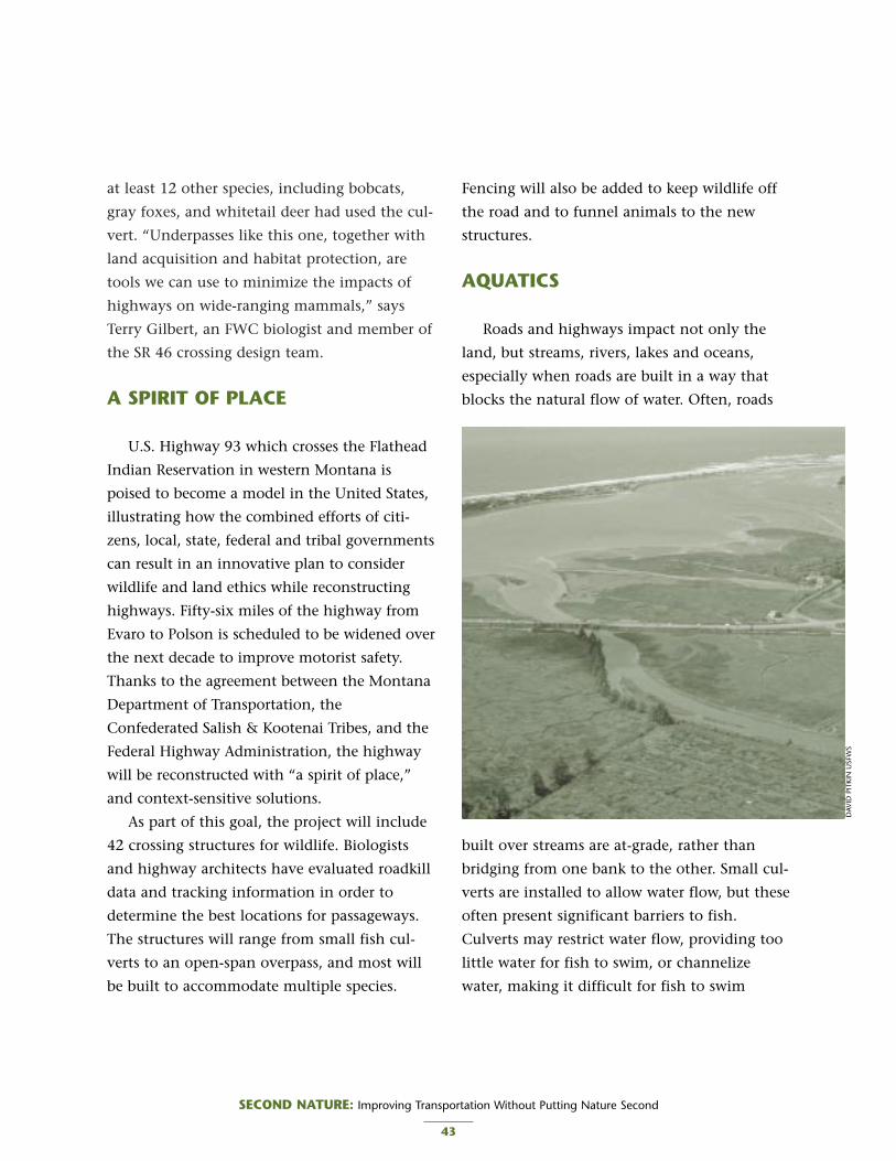
at least 12 other species, including bobcats,
gray foxes, and whitetail deer had used the cul-
vert. “Underpasses like this one, together with
land acquisition and habitat protection, are
tools we can use to minimize the impacts of
highways on wide-ranging mammals,” says
Terry Gilbert, an FWC biologist and member of
the SR 46 crossing design team.
A SPIRIT OF PLACE
U.S. Highway 93 which crosses the Flathead
Indian Reservation in western Montana is
poised to become a model in the United States,
illustrating how the combined efforts of citi-
zens, local, state, federal and tribal governments
can result in an innovative plan to consider
wildlife and land ethics while reconstructing
highways. Fifty-six miles of the highway from
Evaro to Polson is scheduled to be widened over
the next decade to improve motorist safety.
Thanks to the agreement between the Montana
Department of Transportation, the
Confederated Salish & Kootenai Tribes, and the
Federal Highway Administration, the highway
will be reconstructed with “a spirit of place,”
and context-sensitive solutions.
As part of this goal, the project will include
42 crossing structures for wildlife. Biologists
and highway architects have evaluated roadkill
data and tracking information in order to
determine the best locations for passageways.
The structures will range from small fish cul-
verts to an open-span overpass, and most will
be built to accommodate multiple species.
Fencing will also be added to keep wildlife off
the road and to funnel animals to the new
structures.
AQUATICS
Roads and highways impact not only the
land, but streams, rivers, lakes and oceans,
especially when roads are built in a way that
blocks the natural flow of water. Often, roads
built over streams are at-grade, rather than
bridging from one bank to the other. Small cul-
verts are installed to allow water flow, but these
often present significant barriers to fish.
Culverts may restrict water flow, providing too
little water for fish to swim, or channelize
water, making it difficult for fish to swim
SECOND NATURE: Improving Transportation Without Putting Nature Second
43
DAV
ID P
ITKI
N U
SFW
S

against the current. Anadromous fish — species
that migrate from freshwater to saltwater and
back to freshwater — are the most severely
impacted by fish passage barriers. Ability to
migrate upstream is a critical issue for both
anadromous and local fish species. Restrictions
are especially troublesome to juveniles, which
can’t jump as high, sustain a sufficient level of
energy, or tolerate the changes in water tem-
perature and turbulence.
With developments in science and technolo-
gy, biologists and engineers have designed a
variety of methods to allow fish passage under
roads where they cross streams at grade.
Bridges, baffles and culverts can be designed to
allow the proper water depth and velocity nec-
essary for fish to pass under roads. Washington
DOT and the state Department of Fish and
Wildlife have been working together to correct
more than 500 problem culverts where the
water depth is too shallow, the water velocity
too high, or the outfall drop too far. In Oregon,
54 fish passages have been replaced or modified
and more than 130 miles of habitat have been
restored or enhanced through the state DOT.
SECOND NATURE: Improving Transportation Without Putting Nature Second
44
There’s a place in Washington where “elk call” has taken on a whole new mean-
ing. Residents of Sequim, Washington know the 80-head herd of Roosevelt elk is
near not by the haunting sound of their bellows, but by flashing road signs that read
“ELK X-ING.”
In recent years, this once small town has become a popular retirement commu-
nity and witnessed unprecedented growth. According to the City of Sequim, as
many as 10,000 vehicles per day pass through the area during the summer travel
season on the Olympic Peninsula. As development has increased, so has traffic and
collisions with elk. Drivers had become accustomed to standard elk-crossing signs.
Although no drivers were seriously injured, as many as nine elk were killed per year.5
After improvements to Highway 101, residents feared elk mortality would grow.
Through a partnership among the Department of Fish and Wildlife, the U.S. Forest
Service, Washington DOT, local tribes and conservation organizations, an inexpensive yet effective solution was devel-
oped in a crosswalk for elk. Biologists equipped several elk with radio-transmitting collars, and Washington DOT
installed six radio-activated warning signs along a three-mile stretch of Highway 101 where the herd regularly crosses
to reach the northern end of its range. As the herd approaches the highway, the radio collars activate the signs to
warn motorists that elk are near. Because the signs light up only when elk are approaching, motorists are less likely to
become habituated to their presence.
The project was funded through a $75,000 grant under the Transportation Enhancements Program. Herding
and collaring the elk cost $13,000, the signs cost $48,000 and radio telemetry stations cost an additional $12,700.
A CROSSWALK FOR ELK
GA
RY Z
AH
M, U
SFW
S

CONCLUSION
For the last century, automobiles and the
roads they require have been the dominant
force shaping the modern American landscape.
There are more cars per capita in the United
States than in any other nation in the world.
An unrivaled Interstate highway system con-
nects major metropolitan areas and is the basis
of our transportation infrastructure.
Unfortunately, many roadways were not
planned or designed with wildlife in mind.
However, science and engineering have con-
verged with solutions, and several states are
retrofitting existing roads to protect biodiversi-
ty. While wildlife crossings are not a panacea,
they can go a long way toward restoring con-
nectivity where roads have fragmented habitat.
RECOMMENDATIONS
■ Conduct habitat connectivity studies to
determine where passageways are needed.
Locate structures in existing migration routes.
■ Retrofit existing roads with wildlife passage-
ways. Consider the full range of options,
from at-grade, non-structural approaches to
land bridges.
■ When planning, designing and building
wildlife crossings, ensure the future viability
of habitat on either side through land acqui-
sition or easements.
■ Conduct post-construction monitoring on
the effectiveness of passageways.
■ Increase the use of signage to make motorists
aware of wildlife in the area.
■ Reduce speed limits in wildlife areas.
SECOND NATURE: Improving Transportation Without Putting Nature Second
45
RESOURCES
Critter Crossings: Linking Habitats and Reducing Roadkillhttp://www.fhwa.dot.gov/environment/wildlifecrossings/
Wildlife Habitat Connectivity Across European Highways, FHWAhttp://www.international.fhwa.dot.gov/wildlife_web.htm
National Transportation Enhancements Clearinghouse http://www.enhancements.org/
Humane Society of the United States: Safe Passage for Wildlifehttp://www.hsus.org/ace/13409
Wildlife Crossings Toolkit http://www.wildlifecrossings.info

1. Richard T. T. Forman, Daniel Sperling, et al. RoadEcology: Science and Solutions. (Washington, DC.,Island Press, 2003)
2. Wildlife Habitat Connectivity Across EuropeanHighways, FHWA, 2002.
3. US Census,http://quickfacts.census.gov/qfd/states/12000.html
4. Defenders of Wildlife, Habitat & Highways Campaignhttp://www.defenders.org/habitat/highways
5. Elk, Drivers Benefit from Crossing Project, NorthwestIndian Fisheries Commission Newsletter, Summer 1999.
SECOND NATURE: Improving Transportation Without Putting Nature Second
46
WILDLIFE CROSSINGS AND TEA-21
Since 1991, transportation programs that receive federal aid have been required to consider
environmental, cultural, economic, and social conditions in an effort to create a more balanced
transportation system that provides people with choices and with a richer experience. At the heart
of this effort is the Transportation Enhancements (TE) program, which provides federal reimburse-
ment for community-based activities that are “more than asphalt, concrete, and steel.” Eligible
projects include pedestrian and bicycle facilities, scenic preservation and historic restoration.
When ISTEA was reauthorized in 1998, Defenders of Wildlife worked with members of Congress to
include “Provision of Wildlife Connectivity” as an eligible Transportation Enhancements activity.
Interest groups, local governments and state agencies can now apply for federal funding to retrofit
existing roads with crossing structures for wildlife.
OPPORTUNITIES FOR REAUTHORIZATION
■ Continue funding for the Transportation Enhancements Program at current levels or higher.
Encourage states to develop fair and accessible procedures for TE program fund distribution.
■ Provide research funding for statewide and national habitat connectivity studies.
■ Enable states to build necessary crossings even when no additional road improvements are
planned in those areas.
■ Create a safety grant program to encourage states to install crossings for human safety as well as
habitat connectivity. See Title II, § 2003 Occupant protection incentive grant program.
Federal lands, including national parks,
forests, wildlife refuges and monuments
embody one quarter of the United States
and provide habitat for nearly two-thirds of all
species that are listed as threatened or endan-
gered. Twelve percent of these species are
restricted largely to federal public lands, on
which they depend for survival.1 These lands,
then, are critical for biodiversity conservation.
The visitors they attract are also critical for
local and regional economies.
Federal lands are managed primarily by five
agencies: the Fish and Wildlife Service
(USFWS), which manages the National Wildlife
Refuge System; the Bureau of Land
Management (BLM), which is responsible for
national monuments; the National Park Service
(NPS); the Forest Service (USFS); and the
Department of Defense (DoD). While these
agencies have different missions and are guided
by different regulations, all are mandated to
conserve and sustain the natural resources
found on their lands.
With the exception of military bases, most
federal lands are open to the public and to
vehicle traffic. More than 300 million people
visited national parks in 1999 alone.2 More
than 38.8 million visitors came to national
wildlife refuges and hatcheries in 2001. Refuge
visitation is expected to increase to more than
61.2 million by 2009.3
FEDERAL LANDS HIGHWAY PROGRAM
The task of providing safe and adequate
access to public lands is shared by the individ-
ual agencies and Federal Lands Highway
Program (FLHP), which is responsible for some
90,000 miles of roads that are owned by public
authorities or the federal government and are
not under state or local responsibility. The
agency is administered by the FHWA as an
adjunct to the Federal-Aid Highway Program.
FLHP also provides modest funding for alterna-
tive transportation programs in national parks,
such as shuttle buses, ferries and bicycle and
pedestrian trails.4
Because FLHP has been largely devoted to
building roads instead of providing access and
mobility, America’s public lands are increasingly
threatened by vehicle overcrowding, traffic con-
gestion and air pollution. As outdoor recreation
becomes more popular, millions of Americans
flock to public lands every day. However, trans-
portation options within public lands are limit-
ed, diminishing the overall visitor experience
and environmental quality. Many areas are
readily accessible only by personal vehicle, leav-
ing visitors mired in traffic jams, rather than
enjoying the activities and scenery. In Great
Smoky Mountains National Park, it can take
four to six hours to drive an 11-mile loop.5
SECOND NATURE: Improving Transportation Without Putting Nature Second
47
7PUBLIC LANDSPUBLIC LANDS

Due to the volume of vehicles, public lands
suffer from air quality problems that rival
major metropolitan areas. According to the
National Parks Conservation Association
(NPCA), in 2001 Sequoia and Kings Canyon
National Park in the southern Sierra Nevada in
California recorded 61 days when the air was
unhealthy to breathe because of ground-level
ozone.6
High road density and traffic volume threat-
en wildlife on some federal lands, as well as the
people who visit. Many species are restricted to
public lands because suitable habitat is not
available elsewhere. Among these species, the
grizzly bear (Ursus arctos), gray wolf (Canis
lupus), and caribou (Rangifer tarandus) are
known to avoid areas adjacent to highways
because of the noise and human activity associ-
ated with roads. In fact, road density is among
the most reliable predictors of wolf habitat. As
road density increases within our public lands,
habitat quality decreases exponentially.
Increased attendance and increased vehicle
traffic also increase the number of animals
SECOND NATURE: Improving Transportation Without Putting Nature Second
48
Federal Lands in the U.S.

killed by vehicles. According to a NPS study,
939 large mammals were killed by vehicles
within Yellowstone National Park between
1989 and 1996.7 Eventually, public lands will
cease being suitable habitat for some of the
most magnificent of wildlife species.
Without wildlife and the high quality habi-
tat they need, public lands will also cease being
suitable vacation destinations for tourists.
Gateway and surrounding communities rely
heavily on adjacent public lands for tourist dol-
lars.8 Visitors come from across the country
and around the globe to enjoy America’s natu-
ral wonders.
Wildlife associated recreation supports rural
economies and added $50 billion to the
national economy in 1996 alone, according to
a Forest Service report.9 National Park Service
analysts estimated that the 1.4 million visitors
to Shenandoah National Park in 1992 spent
more than $45 million in surrounding coun-
ties. In addition, combined spending by NPS
and by the concessionaire operating businesses
on Skyline Drive was estimated at $10.2 mil-
lion.10
More than 82 million U.S. residents aged 16
and older fished, hunted, or watched wildlife
in 2001, spending $108 billion. This amounted
to 1.1 percent of the Gross Domestic Product
(GDP). Of the total amount spent, $28 billion
was for travel, $64 billion for equipment, and
$16 billion for other items. Hunting and fish-
ing drew $70 billion in 2001 — $36 billion on
fishing, $21 billion on hunting, and $14 bil-
lion on items used for both hunting and fish-
ing. Wildlife watchers spent $38 billion on
trips, equipment, and other items.11
Recreational and educational visits to
national wildlife refuges generate substantial
economic activity. In fiscal year 1995, there
were more than 27.7 million such visits. Visitor
spending generated $401.1 million of sales in
regional economies. As this spending flowed
through the economy, more than 10,000 peo-
ple were employed and $162.9 million in
employment income was generated. In some
areas, refuge visitors are major stimuli to the
local economy. Visitors to Chincoteague
National Wildlife Refuge, for example, generate
almost 3 percent of the earned income in
Accomack County, Virginia. Within the
Chincoteague zip code, more than one-third of
the jobs are attributable to refuge visitation.12
SECOND NATURE: Improving Transportation Without Putting Nature Second
49
CO
RBIS

The reintroduction of wolves to Yellowstone
has been a boon to surrounding communities
and businesses. The Fish & Wildlife Service pro-
jected that wolf watching will continue to
attract record numbers of visitors to
Yellowstone National Park and add an addition-
al $23 million annually to the local economy.13
ALTERNATIVE TRANSPORTATIONON PUBLIC LANDS
The interests of gateway communities,
tourism, visitors and wildlife will be best served
by improvements that recognize their interde-
pendence. In order to address traffic congestion,
air pollution, and continued threats to biodiver-
sity, resource agencies and the FLHP should con-
sider providing more visitor friendly and envi-
ronmentally sensible transportation options on
public lands. Instead of continuing with the
roadbuilding agenda that has precipitated these
problems, resources would be better spent on a
system designed to meet the current and future
needs of both human visitors and non-human
residents. It is possible to improve mobility and
visitor experience, and at the same time mitigate
the impacts of existing roads.
Alternatives to the private vehicle are now
offered at many public lands. According to the
NPCA, more than 90 national parks now offer
some form of public transportation for visitors.
The Fish and Wildlife Service offers alternative
transportation at ten or more national wildlife
refuges.14 Another alternative is improved
access for pedestrians and bicyclists. Many visi-
tors may prefer to walk or bike, but find no
sidewalks or trails from gateway communities
to the facility. This forces many people to drive
to and from the facility, adding to traffic tie-
ups. With additional support, alternative trans-
portation can reduce the burden of traffic con-
gestion within public lands, improve visitor
experience and protect biodiversity.
ZION NATIONAL PARK
Not long ago, Utah’s Zion National Park
was overwhelmed by cars, RVs, and tour buses.
SECOND NATURE: Improving Transportation Without Putting Nature Second
50
NAT
ION
AL
PARK
SER
VIC
E

Traffic congestion, lack of parking, air and
noise pollution, and damage to natural
resources frustrated managers and visitors
alike. The park now offers a free shuttle bus
along the Zion Canyon Scenic Drive from
early April through the end of October. Private
vehicles are not allowed during peak visitation
hours. All other parts of the park are open to
private vehicles. The shuttles operate in two
loops, one making six stops in the town of
Springdale and the other making eight stops at
points of interest in the park. Each bus is fully
accessible and can carry two bicycles. There is
room onboard for packs, coolers and strollers.
Two trams in the fleet are electric-powered.
“Initially, people [visiting Zion] were a lit-
tle hesitant and didn’t know if they’d like
being separated from their cars, but our mem-
bers have told us it works very well,” said
Rolayne Fairclough of the Utah office of the
American Automobile Association (AAA).15
SANTA ANA NATIONAL WILDLIFEREFUGE TRAM
For more than 15 years, an open air, inter-
pretative tram has taken visitors through Texas’
Santa Ana National Wildlife Refuge. The tram
runs four times daily from Thursday through
Monday during peak season, and private vehi-
cles are prohibited on the drive when the tram
is in service. The tram holds up to 30 people
and makes a tour loop of 7.5 miles. The tram
fare is $3 for adults and $1.50 for children, and
free for school groups.
The tram service is a cooperative effort with
the Valley Nature Center (VNC), a local, non-
profit organization dedicated to environmental
education, which supplies a driver and a narra-
tor for each tour. Annual ridership exceeds
6,000 passengers, earning about $18,000 in
fares for VNC. The Santa Ana NWR supplies
the tram, gasoline, and maintenance for the
vehicle, with an annual budget of $5,000.
CONCLUSION
Public lands are the cornerstones of our natu-
ral heritage, providing Americans with recreation,
food and fiber, watersheds and scenic beauty.
These lands hold a wealth of amenities, not the
least of which is a repository for our nation’s
imperiled biodiversity. These lands should not be
sequestered, but must remain accessible to
Americans who support them. However, attempts
to accommodate visitors should not destroy the
very amenities that draw them in the first place.
Public lands support local communities, the
travel and tourism industries and resident
wildlife in a mutually beneficial relationship.
That which threatens one, threatens all.
Solutions to traffic congestion, polluted air and
degraded habitat will not be found in continu-
ing to focus on private vehicles as the only
mode to visit public lands. To maintain mobili-
ty and environmental quality, resource agen-
cies and the FLHP must provide visitors with
environmentally sensible transportation
options. Increase mobility, not lane miles.
Accommodate visitors, not vehicles.
SECOND NATURE: Improving Transportation Without Putting Nature Second
51

RESOURCES
USFWS Refuge Roads http://refuges.fws.gov/roads/index.html
Roads, Parking Lots, Bridges and Trails: Conditions and Future Needs U. S. Fish andWildlife Service, July 2002 http://refuges.fws.gov/roads/ResourcePaper.pdf
National Parks Conservation Association http://www.npca.org/across_the_nation/visitor_experience/tea21.asp
Federal Lands Highway Program http://www.fhwa.dot.gov/flh/
Alternative Transportation in the National Parkshttp://www.nps.gov/transportation/alt/index.htm
Federal Lands Alternative Transportation Systems (ATS) Study: Summary of National ATSNeeds http://www.fta.dot.gov/library/policy/fedland/v3/asses.pdf
RECOMMENDATIONS
■ Maintain roads on public lands in a manner
consistent with the management of sur-
rounding natural resources, including
wildlife, both terrestrial and aquatic.
■ Practice context-sensitive solutions in roads
and highways on public lands. Retrofit exist-
ing roads to reduce their intrusion on the
landscape and increase habitat connectivity.
■ Weigh the need for additional roads against
the increased impact on natural resources.
■ Increase public awareness of wildlife needs
through reduced speed limits, signage and
informational pull-outs.
■ Reduce the need for individual motorized
access to public lands by improving multi-
modal infrastructure, such as bike paths, hik-
ing trails and trams.
■ Use only native species in right-of-way vege-
tation management on public lands.
SECOND NATURE: Improving Transportation Without Putting Nature Second
52

SECOND NATURE: Improving Transportation Without Putting Nature Second
53
PUBLIC LANDS AND TEA-21
Authorizations for FLHP in TEA-21 totaled $4.1 billion for fiscal years 1998 through 2003. Funding is
provided for the three existing categories of Federal Lands highways — Indian Reservation Roads (IRR), Park
Roads and Parkways, and Public Lands Highways (discretionary and Forest Highways) — and for a new cate-
gory; Refuge Roads, which are federally owned public roads that provide access to or within the National
Wildlife Refuge System. FLHP funds can be used for alternative transportation facilities within public lands,
national parks, and Indian reservations and can also be used as the state or local match for most types of
Federal-aid highway projects. Procedures and a fund allocation formula for the IRR program are developed
through negotiated rulemaking with Indian tribal governments.
OPPORTUNITIES FOR REAUTHORIZATION
■ Reauthorize and fully fund the National Scenic Byways, Emergency Relief for Federally Owned Roads,
Recreational Trails and Transportation Enhancements programs, all of which support public lands.
■ Increase funding for repair and maintenance of transportation facilities on public lands. Specify that
funding is NOT to be used for additional road-building.
■ Provide dedicated funding for alternative transportation on public lands.
1. http://www.defenders.org/publiclands/
2. National Parks Conservation Association,http://www.npca.org/about_npca/
3. The number of visitors for FY 2001 was based on infor-mation obtained from the Refuge ManagementInformation System. The estimated number of visitorsfor FY 2002 is based upon the average rate of growthduring the 1995-2001 time period. Roads, Parking Lots,Bridges and Trails Conditions and Future Needs U. S.Fish and Wildlife Service, July 2002
4. Federal Lands Highway Program,http://www.fhwa.dot.gov/flh/
5. NPCA,http://www.npca.org/across_the_nation/visitor_experi-ence/tea21.asp
6. Code Red: America’s Five Most Polluted National Parks,NPCA
7. Influence of Vehicle Speed and Vegetation Cover-Typeon Road-Killed Wildlife in Yellowstone National Park.2001, Gunther, Kerry A. The Wildlife Society AnnualMeeting.
8. Gateway communities are cities and towns that borderlate public land holdings such as national and stateparks, forests, or wildlife refuges.
9. Flather, C.H., S.J. Brady and M.S. Knowles. 2000. WildlifeResource Trends in the United States.
10. Code Red: America’s Five Most Polluted National Parks,NPCA
11. 2001 National Survey of Fishing, Hunting, andWildlife-Associated Recreation, USFWS
12. Banking on Nature: The Economic Benefits to LocalCommunities of National Wildlife Refuge Visitation,USFWS, 1997
13. Duffield, J. W. and C.J. Nehu. 1996. Economics of WolfRecovery in Yellowstone National Park. Transaction ofthe 61st North American Wildlife and NaturalResources Conference.
14. Personal communication with Sean Furniss, RefugeRoads Coordinator, 2003.
15. At more parks, visitors leave the car behind, By ToddWilkinson, The Christian Science Monitor

The single greatest threat to biodiversity
in the United States is loss or degrada-
tion of habitat; a contributing factor in
the decline of 85 percent of the species current-
ly listed by the Department of the Interior as
threatened or endangered.1 Introduced species
are the second greatest cause of species endan-
germent and decline in the U.S. and also
worldwide — far exceeding all forms of har-
vest. Nearly 50 percent of species on the
endangered or threatened species lists are at
risk because of non-indigenous species.
Invasive species degrade habitats and threaten
natives through predation, disease, competi-
tion and/or hybridization. At least three of the
24 known extinctions of listed species were
wholly or partially caused by hybridization
between closely related exotic and native
species.2
Quietly, insidiously — and often by invita-
tion — the U.S. has been invaded. More than
50,000 species of non-native plants, animals
and microbes have taken up home here —
most in the past 70 years. Many are valuable
crops or useful plants that humans brought
from other countries. Others are pests that
have overtaken the habitats of native species,
pushing many towards extinction, causing
extensive crop damage and human and animal
disease.3
Native species have evolved and adapted
within an ecosystem that contains competing
species, predators, and diseases, all of which
limit their abundance. In other words, they are
part of an ecological dynamic that has evolved
over thousands of years. In the absence of
these checks, many non-natives can spread rap-
idly and dominate an area, altering habitats
and evicting native plants and animals. Species
that are not native at a site are variously called
non-native, exotic, alien, adventive, or non-
indigenous species.4
COSTS OF INVASIVES
The ecological cost of invasive species is
rivaled only by the economic cost. In a 2000
damage assessment study, Environmental and
SECOND NATURE: Improving Transportation Without Putting Nature Second
54
8NATIVE VEGETATIONNATIVE VEGETATION
BENEFITS OF NATIVE SPECIES
1. Erosion control
2. Vegetation management
3. Biodiversity
4. Wildlife habitat
5. Wetland mitigation
6. Endangered species
7. Water quality
8. Hardy vegetation
Adapted from "Reassessing Beautification: More Than anAesthetic Goal" by Bonnie L. Harper Lore, FHWA

Economic Costs of Nonindigenous Species in the
United States, a team of researchers from
Cornell University estimated that invasive
species are responsible for at least $137 billion
a year in economic losses.
The losses related to plants alone total
$36.6 billion annually, as follows:
• Crop losses cost $23.4 billion a year and an
additional $3 billion is spent on herbicides to
control them.
• In grazing and pastureland, invasives result in a
loss of forage that amounts to $1 billion a year.
Ranchers spend about $5 billion each year to
control invasive and toxic weeds in pastures
and rangelands, but they continue to spread.
• Homeowners spend an estimated $500 mil-
lion a year and golf courses spend $1 billion
a year to control weed invaders.
• An estimated $100 million is also spent to
control aquatic weeds that clog waterways
and alter natural ecosystems.5
Today, as much as 17 percent of North
American flora, and up to 33 percent of indi-
vidual state floras are made up of exotics. Each
day, approximately 4,600 acres of land is
invaded by invasive plants.6 Nowhere is this
more evident than along the four million miles
of roads and highways that crisscross the coun-
try. Because they disturb natural habitats,
transportation systems can facilitate the spread
of plant and animal species outside their natu-
ral range. With 12 million acres of land con-
tained within public rights-of-way, transporta-
tion agencies are also land managers on a
grand scale. Even along some of the most
remote roads, evidence abounds of introduced
species. Since roadbuilding began, our rights-
of-way have been inundated with non-native
species — mostly by accident, some times by
design, and often in well-intentioned but
harmful attempts to “beautify” the roadside.7
The management of roadside vegetation has
always been a reflection of prevailing attitudes
and the current level of understanding of ecol-
ogy. During the 1930s, roadsides were main-
tained as if they were the nation’s front yard.
The labor-intensive planting and mowing that
SECOND NATURE: Improving Transportation Without Putting Nature Second
55
Purple loosestrife, a European native popular as an orna-
mental plant in the early 1800s, has invaded wetlands in
48 states, and is blamed for crowding out 44 native plants
and endangering wildlife that depends on those natives.
The economic damage of purple loosestrife is estimated at
$45 million a year for control and loss of forage crops.
NO
RMA
N E
. REE
S, U
SDA
ARS
, WW
W.IN
VASI
VE.O
RG

this required was significantly reduced in the
1950s with the introduction of agricultural her-
bicides. Beautification became a major objec-
tive of state highway agencies in the 1960s.
During the 1970s, a growing appreciation for
the environment led to a more ecological
approach to roadside management. By the
1990s, it was understood that none of these
previous aesthetics were mutually exclusive or
necessarily incompatible with ecology. The idea
grew that the country’s roadsides should reflect
the natural beauty and biodiversity of each
region, and that a new aesthetic could be built
through better planning based on an under-
standing of natural heritage. The benefits of
this include roadsides that are more ecological-
ly diverse, that provided suitable habitat for
wildlife, that showcase local character, that
control erosion, that require reduced use of
water, fertilizer and other chemicals, and that
also require less maintenance.8
When highway construction began in the
early 20th century, the objective of roadside
vegetation management was to establish an
inexpensive, attractive and fast-growing slope
stabilizer. Depending on the region, native
species may or may not have met all of these
objectives. Where native flora was too costly,
grew too slowly, or was deemed unattractive,
non-native species were often planted. As a
result, public rights of way became clogged
with invasive species such as kudzu and grass-
es. Some of these invasives spread beyond the
right of way, onto adjoining private and public
property, further degrading habitat and reduc-
ing biodiversity. Decisions based only on cost,
ease of use and driver safety fail to consider the
negative consequences for the roadside envi-
ronment and beyond.
Many of these practices and attitudes about
roadside vegetation management continue
today. Roadsides provide a buffer between the
roadway itself and the adjacent commercial,
industrial, agricultural or residential lands, pro-
tecting the private landowner and the highway
user from one another. Roadsides also provide
opportunities for the movement of invasive
species through the landscape. Invasive plant
or animal species can move on vehicles and in
the loads they carry. Invasive plants can be
moved from site to site during spraying and
mowing operations. Weed seed can be inadver-
tently introduced into the corridor aboard con-
struction and maintenance equipment,
through the use of mulch, imported soil or
gravel, and sod. Some invasive plant species
might be deliberately planted in erosion con-
SECOND NATURE: Improving Transportation Without Putting Nature Second
56
"Extinction by habitat destruction is
like death in an automobile accident:
easy to see and assess. Extinction by the
invasion of exotic species is like death
by disease: gradual, insidious, requiring
scientific methods to diagnose."
E.O. WilsonHarvard University

trol, landscape, or wildflower projects. Very
often, such weeds not only threaten the eco-
nomic activities of adjacent landowners, but
also fail to protect the interests of the highway
users. Millions of miles of highway rights-of-
ways traverse public and private lands. Many of
these adjacent lands have weed problems and
the highway rights-of-way provide corridors for
further spread.
On February 3, 1999, Executive Order 13112
was signed “to prevent the introduction of
invasive species and provide for their control
and to minimize the economic, ecological, and
human health impacts that invasive species
cause.” The executive order builds on the
National Environmental Policy Act (NEPA) of
1969, the Federal Noxious Weed Act of 1974,
and the Endangered Species Act of 1973, to
prevent the introduction of invasive species,
provide for their control and take measures to
minimize economic, ecological, and human
health effects. The order established an
Invasive Species Council, called for an Invasive
Species Management Plan and outlined federal
agency duties as follows:
• Identify actions which affect invasive species
• Detect and prevent introductions
• Monitor populations and conduct research
• Restore native populations
• Promote public education
• Discontinue authorization, funding and execu-
tion of all actions which promote introductions
• Consult with the Invasive Species Council
and stakeholders
The executive order reflects great concern
about the impacts of invasive species, and also
the need for action on a national scale. Shortly
after the executive order was signed, then
Secretary of Transportation Rodney E. Slater
issued a “Policy Statement on Invasive Alien
Species,” which directed state DOTs to actively
implement the order. DOTs were given a new
directive to address issues related to roadside
vegetation management, from both the con-
struction and maintenance aspects. Guidance
developed by the FHWA provided a framework
for preventing the introduction of new inva-
sives on rights-of-way and controlling those
invasives that already existed. Control can be a
complex effort involving various governmental
jurisdictions, adjacent landowners, and the gen-
eral public. The FHWA guidelines were devel-
oped with the goal of promoting improved
cooperation, communication, and joint eradica-
tion efforts with agencies at all levels and with
the private sector. To reduce economic and eco-
logical costs and to improve eradication effec-
tiveness, states are encouraged to incorporate
elements of this guidance into their planning
and implementation of construction, erosion
control, landscaping, and maintenance.9
IOWA’S LIVING ROADWAY PROGRAM
Beyond the preventative and reactive, there
is also great potential for state DOTs to become
proactive stewards in roadside management. In
many regions, roadsides provide some of the
last vestiges of native habitat. Prairies and
SECOND NATURE: Improving Transportation Without Putting Nature Second
57

grasslands are our most highly imperiled native
habitats. Roadsides offer excellent opportuni-
ties for restoring some components of the
prairie ecosystem. Together, the Iowa
Department of Transportation and the
Roadside Management Program at the
University of Northern Iowa are making strides
in restoring roadside prairies. In Iowa alone,
where 98 percent of the native prairie habitat
has been lost, the 600,000 acres of roadside
habitat provide more area than all the state,
county, and city parks combined.10 In 1988,
the Living Roadway Trust Fund was established
to provide funds for the development and
implementation of Integrated Roadside
Vegetation Management (IRVM) plans. The
purpose of these plans is to preserve, plant, and
maintain Iowa’s roadside vegetation so that
roadways are safe, visually interesting, ecologi-
cally integrated, and useful for many purposes.
On roadside projects, a minimum of 50 percent
by count of newly planted trees and shrubs
must be considered native to Iowa or be
improved hardy cultivars of a native species.
All grasses and forbs (plants and/or seeds) must
be considered native to Iowa. Introduced
species, other than annual grasses used specifi-
cally as cover crops, will not be funded.11
CONCLUSION
Twelve million acres of land are contained
within our public rights-of-way — an area
roughly half the size of Indiana. Given the
widespread threat of invasive species, resource
managers and transportation agencies have a
responsibility to first stop adding to the prob-
lem. Second, they must attempt to repair the
damage that has already been done. Finally,
where possible, roadsides should be enhanced
to restore the ecological value they once had.
Our nation’s rights-of-way must be managed as
a valuable resource with the most positive
impact on the environment and the economy.
RECOMMENDATIONS
■ Develop and adopt integrated roadside vege-
tation management plans.
■ Coordinate and compile vegetation invento-
ries, classification systems, plans and imple-
mentation strategies for roadsides.
■ Establish a statewide invasives clearinghouse
to provide data, information and technical
assistance to land and resource managers,
action agencies, and developers.
■ Provide additional training in removing
invasive species and reestablishing native
flora on rights-of-way.
■ Develop educational programs and provide
informational materials for the general pub-
lic, landowners, government employees, and
board members as part of a program for inte-
grated roadside vegetation management. The
public does not support what it does not
understand. Through public service
announcements and instructional materials,
state DOTs can shore up the public support
necessary to successfully address invasive
species issues.
SECOND NATURE: Improving Transportation Without Putting Nature Second
58

1. M.L. Shaffer, B.A. Stein. Precious Heritage: The Status ofBiodiversity in the United States. (Oxford UniversityPress, New York, 2000)
2. Don C. Schmitz, Daniel Simberloff, Biological Invasions:A Growing Threat, Issues in Science and Technology,Summer 1997,http://www.nap.edu/issues/13.4/schmit.htm
3. Costly Interlopers: Introduced species of animals, plantsand microbes cost the U.S. $123 billion a year, by AlanHall.http://www.sciam.com/article.cfm?articleID=0002DE3A-E57F-1CD1-B4A8809EC588EEDF
4. Morse, Larry E.; Swearingen, Jil M., and and Randall,John M. (The Nature Conservancy) Defining What isNative: What Is A Native Plant? Available at:http://www.fhwa.dot.gov/environment/rdsduse/rds-duse5.htm
5. Environmental and Economic Costs of NonindigenousSpecies in the United States. Pimentel, David, Lori Lach,
Rodolfo Zuniga and Doug Morrison. BioScience. January2000. Vol 50, No. 1. pp. 53-65.
6. Federal Highway Administration, “Beware of invasivespecies.” Public Roads. 2000 Mar; 63(5):25-29.http://www.tfhrc.gov/pubrds/marapr00/invasiv1.htm
7. Bonnie Harper-Lore, Maggie Wilson. Roadside Use ofNative Plants. (Island Press, Washington, DC, 2000
8. Bonnie Harper-Lore, Maggie Wilson. Roadside Use ofNative Plants. (Island Press, Washington, DC, 2000
9. Federal Highway Administration, “Beware of invasivespecies.” Public Roads. 2000 Mar; 63(5):25-29.http://www.tfhrc.gov/pubrds/marapr00/invasiv1.htm
10. Noss, Reed F. (Conservation Biology Institute) RestoringGrassland Ecosystems: An Opportunity to Save thePieces. Available at: http://www.fhwa.dot.gov/environ-ment/rdsduse/rd_use17.htm
11. Iowa’s Living Roadway Trust Fund, http://www.iowaliv-ingroadway.com.
■ Sponsor pilot projects on the removal and
prevention of roadside invasives, as well as
native species restoration.
■ Conduct research and monitoring of project
sites for invasives.
■ Reward managers and communities for
exemplary efforts in the eradication of inva-
sives and restoration of native species.
SECOND NATURE: Improving Transportation Without Putting Nature Second
59
RESOURCES
Roadside Use of Native Plants, by Bonnie Harper-Lore and Maggie Wilson. Island Press, 2000.
Gateway to Federal efforts concerning invasive species http://www.invasivespecies.gov
Federal Highway Administration Guidance on Invasive Specieshttp://www.fhwa.dot.gov/environment/rdsduse/rdus3_13.htm
Iowa’s Living Roadway Program http://www.iowalivingroadway.com/http://www.uni.edu/irvm/web/
Invasive Species in Transportation Rights of Way: “You Wouldn’t Plant Kudzu, WouldYou?”http://itre.ncsu.edu/cte/TC27HANDOUT.pdf
Executive Order http://www.invasivespecies.gov/laws/execorder.shtml#sec2

SECOND NATURE: Improving Transportation Without Putting Nature Second
60
NATIVE VEGETATION AND TEA-21
TEA-21 does not contain any provisions to assist or encourage states to discontinue using inva-
sive species or to establish native roadside vegetation management programs.
OPPORTUNITIES FOR REAUTHORIZATION
■ Provide funding for statewide inventories of vegetation in rights-of-way. Statewide inventories
will document invasions and aid in statewide planning and management of this issue.
■ Require discontinuation of the use of non-natives in roadside vegetation management. Compile
state lists of target species and appropriate replacements.
■ Support native species restoration. The executive order on invasive species required federally
funded projects to not only prevent the spread of invasive species, but also to actively plant and
manage native plants. Vegetation managers need incentives to move from current practice to a
native vegetation management plan.
■ Institute a start-up, small business loan program for growers to establish native seeds and stock
for use in roadside vegetation. Businesses would be given a five-year grace period before reim-
bursement is expected. Reimbursement would be in the form of native seed and stock to be used
by state DOTs.
■ Provide funding to educate practitioners on native vegetation. State DOTs vary widely in their
capacity to make positive changes in vegetation management. Additional training is needed to
make these changes the standard, rather than the exception.

After a century of roadbuilding, the need
to address conflicts between transporta-
tion and biodiversity has never been
greater. Science has revealed the effects of
roads on wildlife. Engineering has responded
with methods to improve existing roads and
ameliorate impacts. Better planning and policy
can guide future infrastructure investments
away from sensitive natural areas and toward
improved mobility and communities.
Many states and agencies are beginning to
recognize that there are ways to both meet
transportation needs and do a better job of
protecting environmental and cultural
resources. Current efforts to weaken the envi-
ronmental review process under the National
Environmental Policy Act could seriously jeop-
ardize the country’s natural and cultural
resources, while doing little to reduce project
delays. Indeed, an FHWA study recently found
that the most common reason that projects
were delayed was because of lack of funding or
low priority (32 percent), local controversy (16
percent), or the inherent complexity of the
project (13 percent). All of these issues, as well
as changing or expanding the scope of the
project (8 percent) surpass environmental fac-
tors as causes of project delay.1
The states and agencies profiled in this
report have found that expedited project deliv-
ery and improved environmental protection
can be achieved by comprehensively planning
for biodiversity conservation, proactively miti-
gating environmental impacts through conser-
vation banking and wildlife crossings, improv-
ing coordination among transportation and
resource agencies, reducing road impacts and
promoting alternative transportation on public
lands, and promoting the use of native vegeta-
tion in roadway landscaping and maintenance.
Rather than being the exception to the rule,
these practices can become “second nature” to
transportation and resource professionals across
the nation.
SECOND NATURE: Improving Transportation Without Putting Nature Second
61
9CONCLUSIONCONCLUSION
1. FHWA. Reasons for EIS Project Delays. September 2000.
CO
RBIS

1. Integrate conservation planning into
transportation planning.
■ Transportation planners, at the state and
MPO level, should locate and utilize existing
landscape-level conservation plans in their
own planning efforts.
■ In those states that have yet to adopt a
Comprehensive Wildlife Conservation Plan,
individuals should contact the state fish and
game agency and state environmental pro-
tection agency to offer support for such a
plan. Using conservation plan mapping,
transportation officials and MPOs can plan
future road and highway projects that avoid
sensitive and protected areas.
■ Use conservation plans to identify mitigation
sites or banks in advance of project impacts.
■ Provide adequate training on the incorpora-
tion of conservation planning to field and
administrative staff, as well as transportation
planners.
■ Sponsor pre- and post-planning monitoring
to determine the effectiveness of planning
initiatives.
■ Inform and involve the public through com-
munication and outreach tools.
2. Use conservation banking in concert
with large scale conservation plans to
mitigate for unavoidable impacts of
transportation.
■ Use conservation banking when avoiding
and minimizing impacts is impossible and
when consolidating mitigation is biologically
preferable to onsite mitigation.
■ Create a revolving fund from which trans-
portation officials can make interest-free with-
drawals to acquire land that can be banked for
mitigation purposes. Money would be reim-
bursed to the fund from project funding.
■ Use existing conservation plans to determine
the most valuable lands for banking. These
include statewide comprehensive wildlife
conservation plans, regional conservation
plans, endangered species recovery plans and
critical habitat designations.
■ Site conservation banks strategically, with a
particular conservation objective in mind.
■ When establishing conservation banking in
your state, develop a statewide MOU among
all resource and action agencies involved.
3. Coordinate with resource agencies
early, substantively and continuously
throughout transportation planning
and project development.
■ Fund full-time employees at relevant agen-
cies to work exclusively on environmental
and cultural resource reviews for transporta-
tion projects.
■ Establish Environmental Review Committees
composed of high-level representatives from
SECOND NATURE: Improving Transportation Without Putting Nature Second
62
10RECOMMENDATIONSRECOMMENDATIONS

each of the relevant federal and state agencies.
■ Hold regular meetings of the Environmental
Review Committees to discuss upcoming
projects and identify potential conflicts and
impacts.
4. Build wildlife crossings where necessary
to repair ecological damage and restore
habitat connectivity.
■ Conduct habitat connectivity studies to
determine where passageways are needed.
Locate structures in existing migration
routes.
■ Retrofit existing roads with wildlife passage-
ways. Consider the full range of options,
from at-grade, non-structural approaches to
land bridges.
■ When planning, designing and building
wildlife crossings, ensure the future viability
of habitat on either side through acquisition
or easements.
■ Conduct post-construction monitoring on
the effectiveness of passageways.
■ Increase the use of signage to make motorists
aware of wildlife in the area.
■ Reduce speed limits in wildlife areas.
5. Provide alternative transportation and
maintain roads on public lands in a man-
ner consistent with surrounding natural
resources.
■ Practice context-sensitive solutions in roads
and highways on public lands. Retrofit exist-
ing roads to reduce their intrusion on the
landscape and increase habitat connectivity.
■ Weigh the need for additional roads against
the increased impact on natural resources.
■ Increase public awareness of wildlife needs
through reduced speed limits, signage and
informational pull-outs.
■ Reduce the need for individual motorized
access to public lands by improving multi-
modal infrastructure, such as bike paths, hik-
ing trails and trams.
6. Use only native species in right-of-way
vegetation management on public lands.
■ Use only native species in roadside vegeta-
tion management.
■ Develop and adopt integrated roadside vege-
tation management plans.
■ Coordinate and compile vegetation invento-
ries, classification systems, plans and imple-
mentation strategies for roadsides.
■ Establish a statewide invasives clearinghouse
to provide data, information and technical
assistance to land and resource managers,
action agencies, and developers.
■ Provide additional training in removing
invasive species and reestablishing native
flora on rights-of-way.
■ Develop educational programs and provide
informational materials for the general pub-
lic, landowners, government employees, and
board members as part of a program for inte-
grated roadside vegetation management.
■ Sponsor pilot projects on the removal and
prevention of roadside invasives, as well as
native species restoration.
■ Conduct research and monitoring of project
sites for invasives.
■ Reward managers and communities for
exemplary efforts in the eradication of inva-
sives and restoration of native species.
SECOND NATURE: Improving Transportation Without Putting Nature Second
63

Oregon’s Living Landscape: The Oregon BiodiversityProject (1993-1999) was a private sector-based collaborativeeffort that involved a wide range of interests, including fed-eral, state, and local governments, academia, and industryand conservation organizations. Initiated by Defenders ofWildlife in collaboration with The Nature Conservancy ofOregon and the Oregon Natural Heritage Program, theOregon project produced a statewide biodiversity analysisand outlined a broad conservation strategy to guide futureaction. The project developed a number of high qualityproducts, including a full-color atlas that outlined majorfindings and a separate publication on landowner conserva-tion incentives. The Oregon project has been widely recog-nized as a model for future biodiversity projects in otherstates.
Massachusetts BioMap Project: Funded by theMassachusetts Executive Office of Environmental Affairs,the BioMap Project was initiated by the MassachusettsNatural Heritage and Endangered Species Program in thespring of 2000. The goal of the project was “to promotestrategic land protection by producing a map showing areasthat if protected, would provide suitable habitat over thelong term for the maximum number of Massachusetts’ ter-restrial and wetland plant and animal species and naturalcommunities.” Using GIS technology and state rare speciesand exemplary natural communities data, the BioMap iden-tifies 2,130,000 acres (42% of the state) as important for thelong-term conservation of species and natural communities,of which 1,160,000 acres are Core Habitat (23% of the state)and 970,000 acres are Supporting Natural Landscape (19%of the state). The BioMap is now being used as a tool tofacilitate informed land conservation decisions throughoutMassachusetts. It is being used to help set land acquisitionpriorities, and the Natural Heritage and Endangered SpeciesProgram staff is working to encourage towns to use theBioMap to guide land-use planning decisions and to incor-porate it into their next update of Open Space andRecreation Plans.
Maryland GreenPrint Program and GreenInfrastructure Assessment: In 2001, Maryland’sGreenPrint Program was initiated to protect the remainingecologically significant lands that would be important for
the long-term survival of the state’s native plants andwildlife. The Governor approved $145 million over fiveyears for the program. The purpose of the program is to“identify, using the most up-to-date computer mappingtechniques, the most important unprotected natural landsin the state; link, or connect, these lands through a systemof corridors or connectors; and save those lands throughtargeted acquisitions and easements.” As a component ofthe GreenPrint Program, Maryland’s Green InfrastructureAssessment provides a scientifically based, landscapeapproach to identifying and linking ecologically valuableareas in the state. The purpose of the Assessment was to sys-tematically identify and protect ecologically importantlands, address problems of forest fragmentation, habitatdegradation, and water quality, maximize the influence andeffectiveness of public and private conservation invest-ments, promote shared responsibilities for land conserva-tion between public and private sectors, guide and encour-age compatible uses and land management practices andprovide coordination and targeting of mitigation efforts toenhance urban environments and land conservation goals.
New Jersey Landscape Project: In 1994, the NewJersey Division of Fish and Wildlife’s Endangered andNongame Species Program initiated a statewide landscapeapproach to conserving biodiversity, called the LandscapeProject. The goal of the project was to protect New Jersey’sbiodiversity by conserving rare wildlife populations andtheir habitat. Using Geographic Information Systems (GIS),rare wildlife habitats were mapped by overlaying speciesoccurrence locations with land cover classifications.Identified habitat areas were then ranked according to theendangered status of the species found within the parcel tohelp prioritize conservation and management options. Theproject was designed to provide maps that can be repro-duced at various scales, benefiting agencies, organizations,and landowners at the state, county, and municipal levels.Furthermore, the project maps have been used to guideplanning and regulatory decisions, direct proper manage-ment of public conservation areas, provide conservationtools to local communities, such as the townships ofChester and Delaware, and prioritize land acquisition deci-sions, especially through Green Acres-the state open spaceacquisition program.
SECOND NATURE: Improving Transportation Without Putting Nature Second
64
11APPENDIXAPPENDIX
A. OTHER STATEWIDE CONSERVATION PLANS

SECOND NATURE: Improving Transportation Without Putting Nature Second
65
B. GUIDING PRINCIPLES FOR STATES TO CONSIDER IN DEVELOPINGCOMPREHENSIVE WILDLIFE CONSERVATION PLANS FOR THE
STATE WILDLIFE GRANT AND WILDLIFE CONSERVATION AND RESTORATION PROGRAMS
FINAL: SEPTEMBER 27, 2002
The International Association of Fish and WildlifeAgencies recommends the following guiding principles forthe States, the U.S. Fish and Wildlife Service, and their con-servation partners to consider and apply while developingComprehensive Wildlife Conservation Plans to meet theirobligations under the State Wildlife Grant (SWG) and theWildlife Conservation and Restoration (WCRP) programs.
These Guiding Principles identify goals, objectives, andactions to strive for over time. Few if any will be fully real-ized in any State under what is hopefully just the firstround of conservation program development under SWGand WCRP. Some things must occur from the outset,because they are legally required and/or because they areessential to success. Clearly, broad-scale public participa-tion is an example of one such area. Among the diversestakeholders in this effort are: private, local, State, andFederal agencies and governments, NGOs, etc.
The Comprehensive Wildlife Conservation Plan pro-vides an opportunity for the State wildlife agency to pro-vide effective and visionary leadership in conservation. ThePlan can identify the measures that will be used, the resultsachieved, and the threats and needs that remain withregard to wildlife and wildlife habitat. It is also an opportu-nity to address broader issues and programs, includingenvironmental and wildlife-related education, outdoorrecreation, and wildlife-related law enforcement. Theseother areas can constrain, or enhance, wildlife conserva-tion efforts, and funding and public support for wildlifeconservation can be increased, or at least stretched, byinvolving partners that share those interests.
A: PLANNING PROCESS AND PARTNERSHIPS1. Involve multiple staff levels within each agency, and
broad public-private partnerships, to develop andimplement the Plan.
2. Involve partners that have the authorities necessaryto ensure that the Plan addresses the full range ofissues at hand.
3. Build capacity for collaboration among all partnersengaged in the effort, and make sure the collabora-tion is productive, so trust and confidence grow, andorganizational and interpersonal relationships
become strengths of the Plan.4. Share responsibility and credit for planning and
implementation among all partners, who collectivelyshare responsibility for success of the Plan.
5. Focus on efficiency and effectiveness, so the valueadded in planning and implementation is commen-surate to the funds invested.
6. Ensure that the planning processes and the resultantPlans are dynamic ( so they can be improved andupdated efficiently as new information is gained.
7. Communicate effectively with stakeholders, otherpartners, and the public, early and often.
8. The planning processes, and the decisions made dur-ing planning, should be obvious to those who readand use the Plan, and repeatable ( document theprocesses and the decisions so the next planningcycle can build on this one.
B. FOCUS AND SCOPE1. Base the Plan in the principles of (best science,( (best
management practices,( and (adaptive management,(with measurable goals, objectives, strategies,approaches, and activities that are complete, realis-tic, feasible, logical, and achievable. Describe theseprocesses and practices sufficiently that partnersunderstand what they entail and how they shouldfunction.
2. Address the broad range of wildlife and associatedhabitats, with appropriate priority placed on thosespecies of greatest conservation need and taking intoaccount the relative level of funding available forconservation of those species.
3. Integrate and address wildlife-related issuesstatewide, across jurisdictions and interests, andcoordinate with parallel efforts in other States andcountries.
4. Combine landscape/ecosystem/habitat-basedapproaches and smaller-scale approaches (e.g. focal,keystone, and/or indicator species; guilds; species ofspecial concern) for planning and implementation.
5. Make the Plan an effective, long-lasting blueprint forconservation that provides a broad vision and priori-

ties, so a broad array of organizations, includingother government agencies and NGOs, can help real-ize the vision. The Plan should have sufficient flexi-bility to respond to the full spectrum of conditionsand circumstances likely to be encountered withinthe planning area.
C. FORMAT AND CONTENT1. Make the Plan readable, understandable, and useful,
with well-defined issues, short and long-term goalsand objectives, strategies, and realistic measures ofperformance that enable State agencies and theirpartners to demonstrate accountability.
2. Make full and effective use of relevant existing infor-mation; in particular, integrate appropriate elementsof other plans and initiatives (such as Partners-in-Flight and the many regional and other plans), data-bases, GIS layers, records, reports, other informationsources, and management information systems thatoverlap or complement these Plans.
3. Identify knowledge gaps, as well as areas of knowl-edge, to help focus future efforts to improve under-standing and planning, but do not allow a lack ofinformation to inappropriately limit necessary short-term application of the best available science andgood judgment in decision-making.
4. Make the Plan spatially explicit, to the extent feasi-ble and appropriate, with a full complement of GISand other maps, figures, and other graphics, as wellas appropriate text to provide sufficient detail andconsistency in describing species and habitat condi-tions, conservation needs, conservation recommen-dations, and other issues/actions, so it can be usedeffectively by all partners.
5. Use threats analyses, risk and stressor assessments,and other techniques to help set priorities for goals,objectives, strategies, and activities.
6. In addition to wildlife, address factors that can havesubstantial impact on wildlife conservation, such asmanagement of invasive species, wildlife-related andconservation-related education, law enforcement,
and outdoor recreation.7. Include a comprehensive glossary, so partners and
the public have a shared and common understand-ing of key terms used in the Plan.
8. Develop an updatable information system to moni-tor Plan implementation and the status and trendsof wildlife and habitat.
9. Consider wildlife conservation-related education andwildlife-associated recreation as tools that can helpaccomplishing conservation goals.
D. COMPLETION, OUTCOMES, AND AVAILABILITY1. Provide annual written progress updates on the plan-
ning effort and progress to IAFWA(s CARAImplementation Committee each September, inaddition to annual performance reports that must besubmitted to the U.S. Fish and Wildlife Service pur-suant to Federal Aid guidelines.
2. Ensure that the Plan clearly and definitively meetsState obligations to Congress under the WCRP andSWG legislation, and to the U.S. Fish and WildlifeService with regard to Federal Aid administration.
3. Provide sufficient documentation in or with the Planto facilitate public understanding of the decisionsthat are made, how and why they were made.
4. Make the Plan a driving force in guiding activitiesunder diverse wildlife and habitat conservation ini-tiatives, and usable for helping to inform land-usedecision-making.
5. Make the Plan readily available to the public in vari-ety of media
6. Provide a mechanism for reporting accomplishmentsand tracking progress so local partners are aware ofboth.
7. Ensure that the Plan can be implemented, i.e. that itis administratively and politically feasible, and thatthere are sufficient resources (funding and staff)among the partners to accomplish significant gainsat a large scale, and within an appropriate timeframe, to preserve our Nation(s wildlife heritage.
SECOND NATURE: Improving Transportation Without Putting Nature Second
66

The executive and legislative branches have endorsed theuse of conservation banks as a means to accomplish impor-tant resource management goals. This document providesformal policy guidance on how to achieve this directive.
A conservation bank is a single parcel, or a series ofcontiguous or non-contiguous parcels, of habitat which ismanaged for its natural resource values. The resource bene-fits derived from this management regime are sold as“credits” to project proponents who seek mitigation oppor-tunities to compensate for resource impacts elsewhere.Credits may be generated to meet any number of resourceconservation needs, including compensation for impacts towetlands, threatened or endangered species, Environ-mentally Sensitive Habitat Areas, mudflats, sub-tidal areas,and less sensitive resources.
Conservation banks, if properly established and man-aged, serve several useful functions. First and foremost,banks provide for the conservation of important habitatsand/or habitat linkages. Second, they provide a viable alter-native to the current practice of requiring piecemeal miti-gation for individual project impacts. Individualized miti-gation projects which have little connection with their sur-rounding ecosystem are often much more prone to failurethan a mitigation project which is incorporated into a larg-er, ecosystem-based conservation bank or regional conser-vation plan. Third, conservation banks can take advantageof economies of scale that are often not available to indi-vidualized mitigation projects. Fourth, conservation banksprovide significant incentives for private landowner partici-pation and represent one of the best examples ofprivate/public partnerships in an era of shrinking budgetresources. Fifth, conservation banks can be a major fundingcomponent for the creation of an ecosystem preserveunder a regional conservation plan. Sixth, and finally, con-servation banks simplify the regulatory compliance processwhile achieving greater conservation goals.
CONSERVATION BANKING For purposes of providing guidance on conservation
banking, all Departments shall designate and train person-nel to actively work with potential bank developers inaccordance with the following precepts:
1. The priority for mitigation should be to accomplishit at a site which provides for the long-term conser-
vation of habitat and species. As such, off-site miti-gation is specifically sanctioned in the context of anotherwise permissible conservation bank.
2. A bank may be established pursuant to regulatorypermit or contract between the bank developer andthe appropriate regulatory agency(s). Where a bankis established pursuant to contract, care must betaken to create a legally enforceable instrument.
3. There is no minimum or maximum size of a conser-vation bank and it may be divided into clearlydefined subareas. However, the bank and each of itssubareas (if any) should be large enough to be eco-logically self-sustaining or part of a larger conserva-tion strategy that has a reasonable expectation ofbeing accomplished.
4. Upon sale of the first credit in the bank or subarea,the land in the bank or subarea must be permanent-ly protected through fee title or conservation ease-ment. The land-use restrictions should run with theland and be recorded in the appropriate county(s) ofjurisdiction.
5. Before selling bank credits, a proposed conservationbank should be approved by the appropriate resourcemanagement agency(s). Basic elements in anyapprovable bank proposal should include, but arenot limited to:
a. identification of a bank manager; b. identification of the geographical boundaries
of the bank and the service area of the bank;c. provision for fundamental property protection
measures (e.g., fencing some or all of the bankproperty if deemed appropriate, control of off-road vehicle use, etc.);
d. provisions for the resolution of current orprospective land use conflicts involving thebank lands (e.g., rights-of-way issues, existinguse issues, adjacent land-use issues);
e. provisions requiring an annual report by thebank manager to be submitted to the appropri-ate regulatory agency(s).
6. Prior to the sale of credits, a resource managementplan should be approved by the appropriate regula-tory agency(s). A sufficient level of funding withacceptable guarantees (e.g., cash, letters of credit,
SECOND NATURE: Improving Transportation Without Putting Nature Second
67
C. OFFICIAL POLICY ON CONSERVATION BANKSDouglas P. Wheeler James M. StrockThe Resources Agency California Environmental Protection Agency
April 7, 1995

public charity, public funding mechanism) should beprovided to fully ensure the operation and mainte-nance of the bank as may be required.
7. Provision should be made for long term manage-ment of bank lands after all the mitigation creditshave been awarded. Generally, land managementresponsibilities should ultimately vest in a resourcemanagement agency or qualified non-profit organi-zation, although a private entity may be an accept-able long-term manager.
8. Provision should be made for ensuring implementa-tion of the resource management plan in event ofnon-performance by the bank owner and/or opera-tor.
9. Provisions should be made in any bank establish-ment for the monitoring and reporting of identifiedspecies/habitat management objectives.
10. An easement or other agreement should be estab-lished at the bank in favor of appropriate resourcemanagement agency(s) guaranteeing the agency’sright of entry onto bank lands for the followingpurposes:
a. Inspections; b. Specified resource management responsibilities; c. Quality Assurance/Quality Control review with
regard to bank management and operation; d. Resource management should the bank opera-
tor fail to implement prescribed resource man-agement responsibilities.
11. Bank credits should be established by reference toan environmental baseline which may, but neednot be, assessed at the time of the bank creation.This baseline will be used to establish credits for anumber of categories requiring resource manage-ment, including, but not limited to, the following:
a. Resource Preservation (the preservation of spec-ified resources through acquisition or otherappropriate means);
b. Resource Enhancement (the enhancement of adegraded resource);
c. Resource Restoration (the restoration of aresource to its historical condition);
d. Resource Creation (the creation of a specifiedresource condition where none existed before).
12. The award of bank credits should be negotiated ona case-by-case basis between the project proponentin need of the subject credits, the regulatoryagency(s) of jurisdiction, and the bank manager.Generally:
a. Credits may be negotiated for available orprospective resource value establishment.
b. Credits may be based on habitat acreage, habi-tat quality, contribution to a regional conserva-tion strategy that has been approved by theappropriate regulatory agency(s), or any otherbasis acceptable to the regulatory agency(s).
c. Actual awards of bank credits need not be with-held pending full realization of the targetedresource value at the bank. Credit availabilitymay vary in accordance with agreed upon per-formance criteria for the development of theresource value in question.
d. Awarded bank credits, subject to the approvalof the regulatory agency(s), should be madetransferrable.
13. Whether out-of-kind mitigation credit will beallowed at a particular bank will require a fact-spe-cific inquiry on a case-by-case basis for the projectcreating the impacts.
14. The creation of any conservation bank should belisted with the Resources Agency in accordancewith forthcoming guidance for purposes of main-taining a statewide bank inventory.
CONCLUSION Conservation bank agreements developed between the
bank developer and the appropriate regulatory agency(s) inaccordance with the preceding precepts shall be consideredconsistent with state policy regarding conservation banks,assuming no violation of federal and state laws. Trainingmanuals on this subject are forthcoming.http://ceres.ca.gov/wetlands/policies/mitbank.html
SECOND NATURE: Improving Transportation Without Putting Nature Second
68

I. INTRODUCTION
The CETAS Group was formed in June of 2000 inresponse to several issues: a greater and greater sense ofurgency about environmental stresses; the response to TEA-21 streamlining; the complexity of environmental regula-tion and planning requirements; and the need to updateand fully implement the existing NEPA/404 Accord. Oldprocesses were no longer adequate for the tasks at hand.The CETAS group was formed out of desire for a more har-monious and streamlined process for meeting agencies’missions.
II. GOAL
The goal of this Group is to identify and implementcollaborative opportunities to help each participatingagency realize its mission through sound environmentalstewardship, while providing for a safe and efficient trans-portation system. Our direction for achieving this goal isderived from Table 1, which sets out the Group’s vision.
III. BALANCING OF VALUES
In pursuing this goal, the ethic is one of balancingenvironmental and transportation values. Through earlierand more effective communication, mutual education, andprocess change, greater environmental benefits can beaccomplished, while minimizing costs and delays. The ulti-mate goal is the improved outcome for each agency’s mis-sion.
When making environment-related decisions, CETASparticipants share the responsibility to balance competingbusiness needs and requirements with appropriate environ-mental stewardship. Schedule, cost, safety, quality, publicinput, regulator input, fish and wildlife habitat and otherfactors are all top priority, while none have first priority.Under §7(a)(1) of the Endangered Species Act, the FederalHighway Administration and the Oregon Department ofTransportation shall use all of their authorities to conservelisted species and the ecosystems upon which they depend.With that vision, transportation planning and programs
will use this authority to protect and restore habitat forlisted species.
Under the authority of the National EnvironmentalPolicy Act, the Fish and Wildlife Coordination Act, theClean Water Act, and other statutes, typically avoidance ofenvironmental impacts is the highest priority. The beststewardship of the resource is to avoid harm in the firstplace. If the resource cannot be avoided, then minimizeharm to the maximum extent possible and practicable.Where the resource cannot be avoided, and where mini-mization leaves harm to the resource, mitigate or offset theharm. In addition, sound environmental stewardshiprequires that, on all projects, decision-makers be mindfulof environmental enhancement opportunities, and takeadvantage of them when appropriate.
IV. MEMBERSHIP AND RESPONSIBILITIES
A. The CETAS is composed of one representative, andone alternate from each of the following agencies:Oregon Department of Transportation, FederalHighway Administration, Oregon Division of StateLands, Oregon Department of EnvironmentalQuality, Oregon Department of Fish and Wildlife,Department of Land Conservation andDevelopment, Environmental Protection Agency, USFish and Wildlife Service, US Army Corps ofEngineers, and National Marine Fisheries Service.
B. CETAS members agree to:• come to the CETAS meetings to share their individual
opinions and knowledge,• represent their agency’s position fully,• listen respectfully,• ensure that the CETAS decision reflects agency posi-
tions rather than individual opinions, and receivesfull understanding and full agency ratification, and
• ensure that their agency develops an implementationplan, where relevant, for CETAS work products andthe long-term implementation of CETAS agreements.
C. Decision-Making. Subject to statutory and legal con-straints the following will occur:
• Decisions will be made by consensus of the partici-
SECOND NATURE: Improving Transportation Without Putting Nature Second
69
D. A VISION FOR JOINT ENVIRONMENTAL AND TRANSPORTATIONSYSTEM STEWARDSHIP IN OREGON COLLABORATIVE ENVIRONMENTAL
AND TRANSPORTATION AGREEMENT FOR STREAMLINING (CETAS)
Charter Agreement

pants. Consensus is defined as the willingness of allthe participants to accept the decision and abide byit. It is understood that the decision may not repre-sent the optimal outcome for any one participant,but it is an acceptable outcome to all.
• By agreeing to consensus, each member supports thedecision.
D. Attendance• Members agree to attend regular meetings of the
CETAS.• An alternate will be thoroughly briefed on the issues
by their agency’s CETAS representative prior to themeetings.
• Seven participants constitute a quorum.
V. MEETINGS
A. Timing of Meetings• ODOT representative will convene quarterly CETAS
meetings for the purpose of information sharing,monitoring of ongoing CETAS work products, andaddressing other work issues,
• ODOT may convene additional meetings as the needarises;
• At the request of two or more agencies, or as specifiedin any of the CETAS work products, ODOT shall con-vene additional meetings.
B. ODOT will provide for minutes.C. Annually, ODOT Environmental Services shall pre-
pare and present a report summarizing and evaluat-ing the work of the CETAS, its workgroups, and theimplementation of its work products.
VI. TASK OF THE CETAS
It is the task of the CETAS to: provide a forum forexchange of information and perspectives, establish collab-orative opportunities for its work groups to resolve, estab-lish work groups, monitor the progress of work groups,approve work group products, implement CETAS agree-ment, monitor the implementation of CETAS agreementsand engage in other activities as the group decides.
VII. WORKGROUPS
A. Workgroups may be used to prepare specific propos-als or draft agreements. Workgroups will:
• be subject to the ground rules established by thischarter, unless otherwise specifically directed;
• to the extent possible, reflect a balance of interests;• make regular progress reports to the CETAS Group.B. The work products should include the following:
conditions of the agreement, education plan, imple-mentation plan, monitoring and assessment mecha-nism, durability of the agreement, conflict resolutionprocess, if appropriate.
C. The Work product shall not be considered final untilapproved by the CETAS.
VIII. ELEVATION OF CONTESTED ISSUES
Elevation should be used whenever participants feel thedecision needs to be made at a higher level, participantsfeel the agreement is not being upheld, or participants can-not concur with a proposed activity. Elevation is a positionstep in appropriately resolving issues. The sequence foreach of the agencies is identified in Table 2.
SECOND NATURE: Improving Transportation Without Putting Nature Second
70