SEC. 25-32S-l6W, HIDALGO COUNTY, - geoinfo.nmt.edu · SEC. 25-32S-l6W, HIDALGO COUNTY, NEW MEXICO...
48
HYDROCARBON SOURCE ROCK EVALUATION STUDY ORGANIC GEOCHEMICAL ANALYSES OF DRY WELL CUTTINGS HUMBLE OIL & REFININGCO.NO. 1 N.M.STATEEAWELL SEC.25-32S-l6W,HIDALGO COUNTY, NEW MEXICO Prepared for New Mexico Bureau of Mines & Minerals Resources Socorro, New Mexico November, 1977 1143-C BRITTMORE ROAD, HOUSTON, TEXAS 77043 COMPANY PROPRIETARY
Transcript of SEC. 25-32S-l6W, HIDALGO COUNTY, - geoinfo.nmt.edu · SEC. 25-32S-l6W, HIDALGO COUNTY, NEW MEXICO...

HYDROCARBON SOURCE ROCK EVALUATION STUDY
ORGANIC GEOCHEMICAL ANALYSES O F DRY WELL CUTTINGS
HUMBLE OIL & REFINING CO. NO. 1 N.M. STATE EA WELL
SEC. 25-32S-l6W, HIDALGO COUNTY, NEW MEXICO
Prepared
for
New Mexico Bureau of Mines & Minerals Resources
Socorro, New Mexico
November, 1977
1143-C BRITTMORE ROAD, HOUSTON, TEXAS 77043
COMPANY PROPRIETARY

New Mexico Bureau of Mines & Mineral Resources Socorro. NM 87801
NEW MEXICO INSTITUTE OF MINING & TECHNOLOGY A DIVISION OF
December 11, 1978
MEMO
TO: Frank E. Kottlowski, Director
FROM: Sam Thompson I11
SUBJECT: Open-file Reports OF 96 and OF 9 7
Geo Chem Laboratories, Inc. are to be placed in the Bureau's open file:
As we discussed, the following two reports from
OF 96:
OF 97:
Hydrocarbon source-rock evaluation study,
County, New Mexico, by P.J. Cernock, Geo KCM NO. 1 Cochise State A well, Hidalgo
Chem Laboratories, Inc., 1976, 4 p. (text), 2 figs., 5 tables (11 p.), 1 appendix ( 4 P.) - Hydrocarbon source-rock evaluation study, Humble Oil & Refining Co. No. 1 State BA well, Hidalgo County, New Mexico, by P.J. Cernock, Geo Chem Laboratories, Inc. 1977, 10 p. (text), 3 figs. (sep.), 8 tables (15 p.) , @ appendix' (1 P.): supplement of 2 p. (text), 3 tables ( 3 P.) .
cc: Paul J. Cernock Robert W. Kel'ley
An Equal Opportuniry/Aff~mati"e Action Institution

SOURCE ROCK EVALUATION ANALYSES CRUDE OIL-SOURCE ROCK CORRELATION
CRUDE OIL CHARACTERIZATION
1143-C BRITTMOR€ ROAD HOUSTON, TEXAS 77043 713/467-7011
July 3, 1978
-232. Sam Thompson III New Mexico Bureau of Mines &
Mineral Resources Socorro, New Mexico 87801
Re: GeoChem Job No. 1050 Humble Oil & Refining Co. No. 1 N. M. State EA Well
Dear Sam:
Please findknclosed the results of the organic geochemical analyses carried out on seven (7) cuttings samples which were collected from the Humble Oil & Refining Co. No. 1 N.M. State BA Well located in Sec. 25-32S-l6W, Hidalgo County, New Mexico.
,
. These samples have been identified by the GeoChem Sample Nos. 1050-001 through -007.
The organic geochemical analyses performed on the cuttings samples comprised hand picking of uncaved lithologies and general lithological description by a geologist, total organic carbon analyses and kerogen isolation, slide preparation and visual assessment. These data are presented in the attached Tables I, lI and III. It; should be pointed out that the analyses performed on these seven (7) samples repre- sent additional analyses to complement the hydrocarbon source rock evaluation study which was performed in November, 1977 on the Humble Oil & Refining Co. No. 1 N.M. State BA Well. This report was sent to you in November of 1977. Please compare these data enclosed herein with data presented in the previously submitted report.
The samples analyzed herein may be defined as having fair organic carbon contents for shales. The sample 1050-001 contains - fair to & organic carbon contents for a limestone sample. The kerogen analyses show that most samples contain predominant amounts of degraded herbaceous type kerogen with secondary amounts of woody type of

Dr. Sam Thompson III -2- July 3, 1978
material being present. Maturations have been defined as a Stage 2 to 2+, thus suggest- ing that these sediments have undergone a moderately mature thermal history. In com- paring these data with data from the earlier report (identified by GeoChem Job Mo. 1001), we see that there is a slight discrepancy in the thermal maturity and visual kerogen maturation. Visual kerogen data for the 1001 report defined thermal maturations rang- ing from 2+ to 3- for samples above and below these samples described for the 1050 re- port. Thus, we appear to have a difference of 2 to 2+ (for samples 1050) compared to a Stage 2+to 3- for samples from Job No. 1001. The visual kerogen type appears very similar, inasmuch as the samples from Job 1001 contained predominant o r secondary amounts of woody and/or degraded herbaceous type kerogens. I requested Ms. Ann Reaugh, GeoChem's palynologist, to look at slides from both sets of samples. Effie stated that the samples examined in this study most probably are more correct on a matma- tion basis. The samples examined from Job No. 1001 contained greater amounts d re- worked material which were more difficult to interpret as reworked material or in-place material. To sum it up, Sam, we feel that this shallower section has a thermal matura- tion ranging from 2 to 2+, o r possibly 2+ to 3-. In either case, we would still remain within the oil generating window. However, with the type of kerogen being present being degraded herbaceous and woody, I would certainly interpret this section as being 82s- prone, rather than oil-prone.
If you have any questions concerning the enclosed data, please feel free to give m e a call and discuss it on the telephone. Enclosed also find an invoice No. 01538 for the Job No. 1050 analyses. I hope that all has gone well for you in the field and that you have an op- portunity to incorporate field data into your regional studies.
Yours very tnfly,
Paul J. Cernock Vice President & Chief Geologist GEOCHEM LABORATORIES, WC.
PJC/bh Enclosures

* . .. . . Tabl e I
Picked Samples
Summaw of Organic Carbon Analyses and Lithologic Description
GeoChem Well Depth Percent Sample Interval Organic Number (feet) Carbon Lithology
1050-001 460 - 470 1050-002 4160 - 4170 1050-003 4170 - 4180 1050-004 4180 - 4190 1050-005 4190 - 4200 1050-006 4200 - 4210 1050-007 4210 - 4220
0.44; 0.37R Limestone, argillaceous, gray. 0.43 Shale, silty, dark gray. 0.56 Shale, silty, dark gray. 0.68 Shale, silty, dark &ray.
0.83 Shale, silty, dark gray. 0.72 Shale, silty, dark gray.
0.90 Shale, silty, dark gray.
* . 1
.. . . Tabl e I
Picked Samples
Summaw of Organic Carbon Analyses and Lithologic Description
GeoChem Well Depth Percent Sample Interval Organic Number (feet) Carbon Lithology
1050-001 460 - 470 0.44; 0.37R Limestone, argillaceous, gray. 1050-002 4160 - 4170 0.43 Shale, silty, dark gray. 1050-003 4170 - 4180 0.56 Shale, silty, dark gray. 1050-004 4180 - 4190 0.68 Shale, silty, dark &ray. 1050-005 4190 - 4200 0.72 Shale, silty, dark gray. 1050-006 4200 - 4210 0.83 Shale, silty, dark gray. 1050-007 4210 - 4220 0.90 Shale, silty, dark gray.
~~ ~ ~

Summary of Organic Carbon and Visual Kerogen
Geochem Well Depth Organic Visual Kerogen Sample Interval Carbon Alteration Number (feet) (% of Rock) m e (1-5 Scale)
1050-001 460 - 470 1050-002 4160 - 4170 1050-003 4170 - 4180 1050-004 4180 - 4190 1050-005 4190 - 4200 1050-006 4200 - 4210 1050-007 4210 - 4220
R = Repeat Sample
Kerogen Key
Predominant; Secondary; Trace 60 - 100%; 20 - 40% 1 - 20%
Analysis
0.44; 0.37R H*;-;W(C) - 2 to2+ 0.43 H*-W;-;C 2 to 2+ 0.56 H*;W;C 2 to 2+ '
0.68 H*;W;C 2 to2+
0.83 H*-W,-; C 2 to2+ 0.90 W;H*;C 2 to2+
0.72 H*;.U;C 2 to 2+
Al = Algal Am= Amorphous-Sapropel H = Herbaceous-E@ore/Cuticle H* = Degraded Herbaceous w = woody c = Cody U = Unidentified Material

i i
t-
E r;
n € 3
n x tn I
m
m
-I

HYDROCARBON SOURCE ROCK EVALUATION STUDY
ORGANIC GEOCHEMICAL ANALYSES OF DRY WELL CUTTINGS
HUMBLE OIL & REFINING CO. NO. 1 N.M. STATE BA WELL
SEC. 25-32S-l6W, HIDALGO COUNTY, NEW MEXICO
SUMMARY
Organic geochemical analyses run on a suite of dried cqttings, collected from the Humble Oil & Refining Company No. 1 N.M. State BA Well, over the interval from 460+ - feet to 14,510+ - feet, indicate the following.:
0 Zone A (46W feet to 7,350+ feet) contains rocks which have a mature, very poor k , condensate, "wetTT and/or tldry" gas source character.
Zone B (7,350+ feet to 10,150+ feet) contains rocks which have a very mature, very po or oil, condensate and asso- ciated llwet" gas source character, and a - fair to good lTdry" thermally derived methane gas source character.
Zone C (10,15W feet to 14,5102 feet) contains rocks which have a very mature to severely altered, very poor oil, con- densate and associated "wet" gas source character. This
0 zone contains two intervals (10,900+- feet to 11,200+ feet and 12,500+ feet to 12,900+ feet) which have a f a i r ~ d r p thermally -derived methane-gas source character.
0 - -
In order of priority, exploration plays in the local area of the Humble Oil & Refining Company No. 1 N. M. State BA Well are interpreted as follows (providing that rese- voir traps are available):
1. Permo-Pennsylvanian Horquilla Limestone Formation (Zone A)
This section should be prospective for moderate to good quantities of Itdry" thermally derived methane gas. This gas is most probably being generated from dark gray shale intervals found within the Permo-Pennsylvanian Horquilla Limestone Formation from 7,350+ - feet to 10,150+ - feet.

2. Devonian Percha Shale within Zone C (Subunit c2: 12,500+ feet to 12.900+ feet)
-
This section should be prospective for fair quantities of ltdry" thermally derived methane gas.
3. Mississippian Paradise Formation within Zone C (Subunit cl: 10,900+ - feet to 11,200+ - feet)
This section should be prospective for fair quantities of "dry" thermally derived methane gas.
Paul J. Cernock GEOCHEM LABORATORIES, INC.

INTRODUCTION
This report summarizes the results of a source rock evaluation study carried out on a suite of dry paleo cuttings collected over the gross well interval 460+ feet to 14,5105 feet from the Humble Oil & Refining Company No. 1 N.M. State BA Well in Sec. 25- 32S-l6W, Hidalgo County, New .Mexico.
The purpose of this study has been to:
- investigate the richness, -, and state of thermal maturity of the hydrocarbon source rocks, and their stratigraphic distribution within the sedimentary sequence penetrated by the Humble Oil & Refining Company No. 1 N.M. State BA Well.
characterize geochemical zones within the stratigraphic section of this well as a basis for any subsequent crude oil - parent rock correlations which may be required in the future.
define the exploration significance of this study with re- spect to future drilling in the local area of the Humble Oil & Refining Company No. 1 N. M. State BA Well.
Analytical
On arrival at GeoChem's Houston laboratory, the Humble Oil & Refining Company No. 1 N. M. State BA Well was assigned the GeoChem Job No. 1001-. Small samples (55 .grams) were hand-picked by a geologist at intervals of approximately 1505 feet through- out this well. %&. Sam Thompson, III, New Mexico Bureau of Mines and Mineral Re- sources, Socorro, New Mexico, provided a list of sample locations with various pri- ority ratings for this well. Utilizing- Thompson's priority listing, and the 150+ foot sample interval guide, a total of seventy-six (76) small samples were hand-picked through- out the well interval from 460+ feet to 14,510t feet. Each of these seventy-six (76) sam- ples was identified by the suf& -001 through"o76 in order of increasing depth.
Each of the seventy-six (76) samples was analyzed for total organic carbon content. On the basis of these results, plus the geological zonation and lithology of the samples, various single or composited samples were selected for more detailed geochemical anal- yses.
-3-

The following lists the number and type of geochemical analyses carried out on the dried well cuttings which were collected from the Humble Oil & Refining Company No. 1 N.M. State BA Well: . ~
Humble Oil & Refining Co. m e of Analysis No. 1 N.M. State BA Well
Organic carbon analyses ...................... 87 Kerogen isolation, slide preparation and
C15+ soxhlet extraction w/deasphaltening.. 11 visualassessment. 18
C15+ quantitative.liquid chromatographic separation...... ........................... 1
C15+ qualitative liquid chromatographic
C15+ paraffin-naphthene (P-N) analysis 11 separation. 10
Vitrinite reflectance .......................... 1
......................... ......
................................ .........
A brief descriptionof thestandard analytical procedures used by GeoChem in this study is presented in Appendix A.
A l l the analytical data obtained in this study, whether used in the ultimate interpreta- tion o r not, is documented in the appropriate Tables I through VIII of this report. The organic carbon values from the screen analysis a re presented in Table I and in Figure 1, the gross lithologic description and organic carbon values are presented in Table I1 and Figure 1, the kerogen organic matter type and alteration data a re presented in Tables 111 and VI and in Figure 1, the (21% extraction, .deasphaltening and liquid chro- matographic separation data are presented in Table IV-A, -B and -C, the CIS paraffin- naphthene (P-N) compositional data are presented in Table V-A and -B and the vitrinite reflectance data are presented in Table MI and in Figure 2. The gas chromatographic traces., showing the molecular distribution of.the C15+ paraffin-naphthene (P-N) hydro- carbons, a re presented in Figure 2. The summary of the various geochemical para- meters which identify three (3) major organic zones in the Humble Oil & Refining Com- pany No. 1 N. M. State BA Well are outlined in Table VIII.
General Information
Two (2) copies of this report have been forwarded to Sam Thompson, III, New Mexico Bureau of Mines and Minerals Resources, Socorro, New Mexico, who auth- orized and coordinated this study. GeoChem has worked closely with Dr. Thompson in performing a source rock evaluation study on the No. 1 N.M. State BA Well. The program was designed to provide the most geochemical information, with the least
-4-

amount of cost. In providing this report tom Thompson, GeoChem has also made another copy of the report for GeoChem's files in Houston, Texas. This report copy will be utilized for .reference purposes in-discussions--with authorized new .Mexico Bureau of Mines and Minerals Resources personnel on specific details of this study.
A l l remaining used and unused, picked and unpicked cuttings samples, CIS hydrocar- bon and nonhydrocarbon chromat fractions and etc. will be returned to- Thompson, New Mexico Bureau of Mines and Minerals Resources, Socorro, New Mexico, under separate cover in the very near future.
The data, interpretations, sample materials and all other matters pertaining to this well study have been treated in a highly confidential manner and are considered pro- prietary to the New Mexico Bureau of Mines and Minerals Resources.
-5-

RESULTS AND INTERPRETATIONS
A. Geological Zonation
The sedimentary sequence penetrated by the Humble Oil & Refining Company No. 1 N. M. State BA Well in Hidalgo County, New Meldco has been divided into a number of discrete geological formations-or groups. Specific formations which were provided to GeoChem in an excerpt from Zeller (1965) include the following:
Formation Depth
Quaternary gravels, etc. . . . . . . . . . . . . . . . . . . . . . . . . . . Surface Lower Cretaceous U-Bar Formation.. . . . . . . . . . . . . . . . 230' Lower Cretaceous Hell-to-Finish Formation . . . . . . . . . 648' Permian Concha Limestone.. . . . . . . . . . . . . . . . . . . . . . . . 995' Permian Scherrer Formation . . . . . . . . . . . . . . . . . . . . . . . 1,522' Permian Epitaph Dolomite.. . . . . . . . . . . . . . . . . . . . . . . . . ' 1,532' Permian Colina Limestone . . . . . . . . . . . . . . . . . . . . . . . . . 4,450' Permian Earp Formation.. . . . . . . . . . . . . . . . . . . . . . . . . . 5,258' Permo-Pennsylvanian Horquilla Limestone.. . . . . . . . . . 6,265'
(Tentative correlations based on fusulinid identifications by Garner L. Wilde are: top Wolfcampian at 6,625', top? Virgilian at 8,755', top? Missourian at 8,935', top Des- moinesian at 9,425', top Derryan at 9,910', top Morrowan? at 10,800'. )
Mississippian Paradise Formation . . . . . . . . . . . . . . . . . . 10,995' Mississippian Escabrosa Limestone . . . . . . . . . ; . . . . . . . 11,425' Devonian Percha Shale . . . . . . . . . . . . . . . . . . . . . . . . . . . . . 12,500' Ordovician Montoya Dolomite; Cutter Member . . . . . . . .. 12,830' Ordovician Montoya Dolomite; Aleman Member . . . . . . . 12,985' Ordovician Montoya D.olomite; Upham Member . . . . . . . 13,097' Ordovician Montoya Dolomite; Cable Canyon Member.. 13,155' Ordovician El Paso Formation.. . . . . . . . . . . . . . . . . . . . . 13,214'
c & P % \.1 S" 1 2 . 8 I
. . % z s m s s 5 + p p i . a ~ e ~ e & o ~ e l o m e -
m ( y + b o b k ] ..................................
Total depth in ........................... 14,585'
B. Geochemical Zonation
The stratigraphic section, penetrated by the Humble OS & Refining Company No. 1 N.M. State BA Well over the interval from 460+ feet to 14,585+_ feet T.D., can -
-6-
I

be subdivided into three (3) major organic zones based primarily on the organic carbon contents, organic matter (kerogen) type and predominance, and the con- tent and composition of the C1,tj+ solvent extractable bitumen and total hy- drocarbon of the fine-grained sediments. The deepest most zone (Zone C from 10,1505 feet to 14,510+ feet) contains two minor subunits which have signifi- cantly different organiz character than the major Zone C section overall. The geochemical. zonation.and subunitization;. both of which are independent of the formation tops, are as follows:
Zone A ............... 46@t feet to 7,350+ feet
Zone B ............... 7,350+ - feet to 10,150+ - feet
Zone C ............... 10,150+ feet to 14,510+ feet Subunit c1.. ......... 10,9007 feet to 11,200: feet Subunit c2.. ......... 12,500; feet to 12,900+ - feet
- -
C. Thermal Maturity and Hydrocarbon Source Character of Sediments
1. Zone A (460+ - feet to 7,3505 feet)
The Lower Cretaceous, Permian Concha through Earp Formations and Permo-Pennsylvanian Horquilla sediments within Zone A have a mature, very poor oil, condensate, tlwet" and/or "dryIT gas source character. The Zone A section, overall, has not generated any significant quantities of hydrocarbons in-place. The section is considered to be non-prospective for any producible quantities of liquid and/or gaseous type hydrocarbons in the local area .of the Humble Oil & Refining Company No. 1 N. M. State BA Well. -
The mature character of these sediments is based on the mature Matura- tion Index of Stage 2+ to 3- for the kerogen isolated from most of the sam- ples from 2,410+ feet to 4,90@t feet. The Maturation Stage then jumps to a very mature Stage 3 to 3+ beyow 6,660+ feet. This jump in Maturation Indices from -2+.to 3- to a 3 to 3+ indicates apossibleunconformity . -. ... or fault.
The very poor oil, condensate, "wet" and/or"dry" gas source character assigned to the Zone A rocks is based on the low organic carbon contents and the type of kerogens predominating in the samples. The very poor liquid and/or gaseous source character assigned to the Zone A sediments is based primarily on the very poor organic carbon contents of the sediments ranging from 0.01% to 0.40%, mean 0.13% (see Tables I, 11, III and WI; Figure 1). It is interpreted that the entire Zone A section
-7-

represents non-source rocks. Possibly minor amounts of dry methane gas may be associated with some of the shale stringers contained in the Colian section.
Zone B 17.350+ feet to 10.150+ feet)
The Permo-Pennsylvanian Horquilla Limestone Formation within Zone B has a very mature, very poor oil, condensate and associated "wet" gas source character, and a fair to good W r y 1 ' thermally derived methane gas source character. This section overall has minimal, if any, amounts of liquid hydrocarbons present within the sediment.?.. Due to the organic matter kerogen type contained in these sediments, and their advanced ther- mal maturity, the Zone B sediments are considered to be beyond the oil generating window. That is, these sediments a re interpreted to have been subjected to temperatures such that only thermally derived methane gas would be present and available for accumulation in.adjacent reservoir traps.
The very mature character of these sediments is based on the very mature Maturation Indices of Stages 3 to 3+ for the kerogen isolated from most of the samples from 7,50% feet to 10,100+ feet (Tables III, VI and W, Fig- ure I), the very mature range of vitrinite reflectance values [ (o/o R ~ ) from 1.76 to 2.36, mean 2.10; Tables VI1 and VIII; Figure 31 and by the overall mature nature of the C15+ paraffin-naphthene (P-N) hydrocarbon fraction (see typical gas chromatographs of Zone B samples in Figure 2).
The very poor oil and condensate source character assigned to these sed- iments, as well as to the overlying Zone A and underlying Zone C sediments, is attributed primarily to the very poor CIS solvent extractable bitumen contents and very poor CIS total hydrocarbon contents of these~samples (see Tables IV-B and Vm). The encouraging factor on the Zone B sediments is the fact that the interbedded shales (dark gray shales) scattered through- out Zone B section do contain @ quantities of total organic carbon content. The organic carbon content values of the Zone B samples range from 0.07% to 1.36%, with a mean of 0.58% (see Tables I, II, III and Vm; Figure 1). These fair to organic carbon contents, in association with predominant amounts of gas-prone woody type kerogens identify the Zone B section as being a - fair to good "dryt1 thermally derived methane gas-source. It is in- .terpreted that this section may contain numerous thin zones of dark gray shales which are good "dry" methane gas sources. Any available.reservoir traps in juxtaposition to these shales in the local area of the Humble No. 1 State BA Well, should be prospective for fair to good quantities of dry meth- ane gas.
-8-

3. Zone C (10,1501- - feet to 14,510+ - feet)
The Mississippian, Devonian and Ordovician rocks within Zone C have a very mature to severely altered, very poor oil, condensate and associated 71wet11 gas source character. It should be noted that this zone does con- tain two intervals (10,900+ feet to 11,2002 feet and 12,500+ feet to 12,900+ feet) which have a fair "dry" thermally derived methane gas source char- acter. These two intervals actually represent the Paradise Formation (shale) and the Percha Shale. It is interpreted that these two shale inter- vals represent fair lldryll thermally derived methane gas sources. Any available reservoir traps in juxtaposition to these shale sections in the local area of the No. 1 State BA Well, should be prospective for fair quan- tities of lldryll methane gas provided that reservoir traps are available.
The vew mature to severely altered character of these sediments is based primarily on the very mature to severely altered Maturation Indices rang- ing from a Stage 3+ to 4- to a Stage 4- to 4 in most of the samples analyzed from 11,150+ - feet to 14,440+ - feet.
The very poor oil, condensate and associated "wett1 gas source character assigned to these sediments is based primarily on the very poor total C15+ solvent extractable bitumen contents and very poor C15+ total hydrocarbon contents contained in these sediment samples (see Tables IV-A and VIE). The fair lldryll thermally derived methane gas source character assigned to the two minor intervals within Zone C is based primarily on fair amounts of organic carbon content for these samples and the presence of the gas- prone coaly type kerogen contained in these samples (see Tables III, VI and Vm; Figure 1).
-
D. Exploration Significance of.This SourceRock Evaluation Study
Examination of the richness, M e (oil, condensate or gas) and state of thermal maturity of the hydrocarbon source rocks penetrated by the Humble Oil & Refining Company No. 1 N. M. State EL4 Well shows that the stratigraphic interval from 460+ feet to 14,510+ - feet, contains zones which have no prospectiveness for in- digenously generated liquid hydrocarbons. One major organic facies zone and minor subunits within another zone are considered to be fair to good sources for "dryf1 thermally derived methane gas. In order of priority, exploration plays a re interpreted as follows:
-9-
Locally:
1.
2.
Zone B (7.350" feet to 10.150+ feet)
The medium dark gray shales interbedded with argillaceous, micritic limestones within the Horquilla Limestone Formation have a very mature, Yew poor oil, condensate and associated llwet" gas source character, and a - fair to good !'dry" thermally derived methane gas source character. This section is considered to have sourced moder-
local area of this well. It is emphasized that the Zone B section in- place has been thermally advanced beyond the oil-generating wind=. Thus, no liquid hydrocarbon potential exists within this section.
- ate quantities of "dryT1 methane gas to available reservoir traps in the -
-
Subunit c1 and c2 within Zone C (10,900+ feet to ll,200+_ feet and 12,5002 feet to 12,9002 feet)~
-
The Paradise Shale and Percha Shales within Subunits c1 and c2 have a very mature to severely altered, vew poor oil, condensate and asso- ciated "wet1' gas source character. However, these two subunits do have a fair "dry" thermally derived methane gas source character. These sediments a re interpreted to have sourced fair quantities of lfdryff methane gas to available reservoir traps in the local area of the Humble Oil & Refining Company No. 1 N.M. State BA Well. Again, it is em- phasized that these sediments are also beyond the oil-generating window, in-place. Thus, no liquid and/or wet gas hydrocarbon potential exists for Zone C section.
-
In summation, this source rock evaluation study defines the local area around the Humble Oil & Refining Company No. 1 N. M. State BA Well 'as being prospective primarily for l ' d r y l l methane gas. Liquid hydrocarbon prospectiveness is minimal, i f ! If theexplorationistis concernedstrictlywith oil and condensate type plays, he should concentrate on encountering section penetrated by this well in an later- ally updip position, and thus, thermally less mature and within the oil-generating window. Likewise, the explorationist may concentrate his efforts in encountering section with a completely different type of organic matter kerogen type -- that is, amorphous-sapropel oil-prone kerogen types. The .reader should realize that the Zone B section, and the underlying Subunits c l and c2, may be prospective for - fair to good quantities of "dry"-methane gas.
-10-

TABLE I
Picked Samples Summary of Organic Carbon Analyses and Lithologic Description
GeoChem Percent Sample Organic Number Well Depth* Carbon Lithology
1001-001
1001-002 1001-003 1001-004 1001-005 1001-006 1001-007 1001-008 1001-009 1001-010 1001-011 1001-012 1001-013 1001-014 1001-015 1001-016 1001-017 1001-018 1001-019 1001-020 1001-021 1001-022 1001-023 1001-024 1001-025 1001-026 1001-027 1001-028 1001-029 1001-030 1001-031 1001-032 1001-033 1001-034 1001-035 1001-036 1001-037 1001-038 1001-039 1001-040
* In feet
460- 470
740- 750 1510- 1520 1560- 1570 1680- 1690 1810- 1820 2010- 2020 2210- 2220 2400- 2410 2500- 2510 2750- 2760 2940- 2950 3030- 3040 3280- 3290 4350- 4360 4450- 4460 4550- 4560 4750- 4760 4890- 4900 5050- 5060 5200- 5210 5290- 5300 5640- 5650 5920- 5930 6350: 6360 6550- 6560 6650- 6660 6850- 6860 7100- 7110 7260- 7270 7400- 7410 7470- 7480 7660- 7670 7920- 7930 7940- 7950 8070- 8080 8240- 8250 8390- 8400 8590- 8600 8790- 8800
0.31 .
0.05 0.01 0.03 0.02; 0.02R 0.02 0.03 0.04 0.18 0.05; 0.07R 0.09 0.18 0.22 0.17 0.36; 0.35R 0.14 0.23 0.16 0.23 0.15; 0.16R 0.13 0.04 0.05 0.05 0.09; 0.08R 0.11 0.12 0.12 ~
0.12 0.11; 0.06R 0.10 1.09 0.07 0.24 0.85; 0.80R 0.08 ,
0.26 0.39 0.34 1.36; 1.32R
Medium dark gray, very argillaceous and..calcareous dolomite. Grayish red silty shale. Light brown limestone. Dolomite. Dolomite. Dolomite. Dolomite. Dolomite. Dolomite. Dolomite.
' Dolomite. Dolomite.
' Dolomite. Dolomite. Dolomite. Limestone. Limestone. Limestone. Limestone. Lime stone. Limestone. Grayish red silty shale. Limestone. Siltstone. Limestone. Medium dark gray., silty shale. Medium dark gray, limy shale. Limestone. Medium dark gray, very calcareous shale. Medium dark gray, calcareous shale. Limestone. .Dark gray shale. Medium~dark gray, silty shale. Medium dark gray, ,silty shale. Dark gray shale. Limestone. Medium dark gray shale. Medium dark gray shale. Medium dark gray shale. Dark gray shale.
. .

TABLE I (continued)
Picked Samples Summary of Organic Carbon Analyses and Lithologic Description
GeoChem Percent I Sample Organic Number Well Depth* Carbon Lithology
1001-041 1001-042 1001-043 1001-044 1001-045 1001-046 1001-047 1001-048 1001-049 1001-050 1001-051 1001-052 1001-053 1001-054 1001-055 1001-056 1001-057 1001-058 1001-059 1001-060 1001-061 1001-062 1001-063 1001-064 1001-065 1001-066 1001-067 1001-068 1001-069 1001-070 1001-071 1001-072 1001-073 1001-074 1001-075 1001-076
* In feet
8840- ,8850 8970- 8980 9080- 9090 9290- 9300 9470- 9480 9570- 9580 9850- 9860 9960- 9970 10050-10060 10180-10190 10460-10470 10820-10830 10990-11000 11100-11110 11350-11360 11490-11500 11690-11700 11900-11910 12090-12100 12300-12310 12400-12410 12600-12610 12700-12710 12800-12810 12900-12910 13000-13010 13140-13150 13300-13310 13450-13460 13600-13610 13750-13760 13900-13910 14050-14060 14200-14210 14400-14410 14500-14510
0.66 0.59 0.97; 0.98R 0.89 0.11 0.22 0.50 0.69 1.10 0.18; 0.17R 0.10 0.06 0.29 0.54 0.16; 0.14R 0.08 0.02 0.13 '
0.12' 0.02; 0.04R 0.09 0.30 0.27 0.88 0.05; 0.11R 0.12 0.08 0.10 0.10 0.08; 0.08R 0.09 0.09 0.10 0.05 0.22; 0.17R 0.13
Dark gray shale. Dark gray shale. Dark gray shale. Dark gray shale. Limestone. Lime stone. Grayish black shale. Dark gray shale. Grayish black shale. Limestone. Limestone. Limestone. Medium dark gray shale. Medium dark gray shale. Limestone. Limestone. Lime stone. Limestone. Lime stone. Limestone. Limestone. Dark gray shale gradink into micrite. Dark gray shale grading into micrite. Dark gray shale. Dolomite. Dolomite. Dolomite. Limestone. Limestone. Limestone. Limestone, Limestone. Limestone. Limestone. Limestone, very argillaceous. Limestone.

Table I1
Organic Carbon Analyses and Gross Lithological Description
GeoChem Sample Number
1001-015D -A
1001-032D - P.
-B
1001-0350 -A
-B
1001-038D -A
-B
1001-040D -A
-B
We1 1 Gross Lithological Description G S A Total Organic Interval Color
Code Carbon
( % of Rock)
4390' ' 0.40 100% Dolomite, massive-cryptocrystalline,
very argillaceous, hard, poor porosity, no show, medium dark gray. N4
7500' 0.50 70% Limestone, chalk grading into
a very argil laceous micrite, moderately hard t o hard, f a i r t o poor porosity, no show, medium l i g h t gray to medium N6 t o dark gray. N4
30% Shale, sl ightly calcareous,
dark gray. s i l t y , blocky, hard, medium
N4
7980' 70% Shale , calcareous, s i l ty ,
blocky.to f iss i le , hard, dark gray. N3 30% Limestone, chalk grading into
an argi~l laceous micr i te , moderately hard t o hard, f a i r t o poor porosity, no show, medium l i g h t gray t o medium N6 t o dark gray. N4
1.16
8400' 0.49; 0.55R 80% Shale, very calcareous, s i l ty ,
blocky, hard, medium dark gray. N4 20% Limestone, micrite, argi l laceous,
hard, poor porosity, no show, medium dark gray. N4
8800' 60% Limestone, chalk grading in to
an argi l laceous micrite, moderately hard t o hard, f a i r t o poor porosity, no show, l i g h t gray t o medium gray. N7 t o N5
blocky t o f i s s i l e , hard, dark gray. N3 40% Shale , calcareous, s i l ty ,
0.50

Table 11 (continued)
Organic Carbon Analyses and Gross Lithological Description
GeoChem We1 1 Gross Lithological Description GSF, Total Organic Sample Interval Color Carbon Number Code ( % of Rock)
1001-043D ~ -A
-B
1001-0490 -A
-B
1001-0540 -A
-B
1001-0620 -A
-B
9100'
10100'
11 !150
60% Shale , calcareous, s i l ty , blocky t o f i s s i l e , hard,
40% Limestone, chalk grading into an argi l laceous micr i te , moderately hard t o hard, f a i r t o poor porosity, no show, l i g h t gray to medium gray.
-dark gray.
70% Shale, limy grading into a l imes tone , s l igh t ly s i l ty , blocky t o f i s s i l e , hard, grayish black.
30% Limestone, chalk grading i n t o a micrite, moderately hard to ha rd , f a i r t o poor
medium dark gray. porosity, no show, white to
60% Limestone, chalk grading into
argillaceous, moderately hard t o hard, f a i r t o poor porosity, no show, l i g h t gray to medium dark gray.
40% Shale, limy grading into a l imes tone , s l igh t ly s i l ty , blocky t o f i s s i l e , hard, grayish black.
. micri te and intramicr i te ,
12610' 50% Shale, noncalcareous, silty,
blocky t o fissile, hard, dark gray.
argillaceaus, hard, poor porosity, no show, dark gray.
50% Limestone, micrite very
0.53
N3
N7 to N5
0.79
N2
N9 t o N4
0.29
N7 to N4
N2
0.36: 0.35R
N3
N3

Table I1 (continued)
Organic Carbon Analyses and Gross Lithological Description
2oChem Well Gross Lithological Description G SA Total Organic imp1 e Interval Color Carbon Amber Code ( % o f Rock)
001-0640 12820' -A 50% Shale, moncalcareous, s i l t y ,
-B 50% Limestone, micrite very .
blocky to f issi le, hard, dark gray.
argillaceous, hard, poor porosity, no show, dark gray.
-A. 90% Limestone, chalk grading into 001-075D 14440'
an argi l laceous micrite, moderately hard t o hard, f a i r t o poor porosity, no show, l i g h t gray t o dark gray.
hard, dark gray. -B 10% Shale, limy, silty, blocky,
0.47
N3
N3
0.20
N7 t o N3
N3

TABLE Ill
Summary of Organic Carbon and Visual Kerogen Analysis
GeoChem Well Organic Visual Kerogen Sample Depth Carbon ' Alteration Number Interval @ of Rock) Type (1-5 Scale)
1001.-009D 1001-013D 1001-015D 1001-Ol7D 1001-019D 1001-027D 1001-032D 1001-035D 1001-038D 1001-040D 1001-043D 1001-048D 1001-049D 1001-054D 1001-062D 1001-064D 1001-071D 1001-075D
2400- 2410 3030- 3040 4350- 4390 4550- 4560 4890- 4900 6650- 6660 7450- 7500 7940- 7980 8360- 8400 8750- 8800 9050- 9100 9960- 9970
10050-10100 11100-11150 12600-12640 12760-12820 13750-13760 14400-14440
10-18 0.22 0.40 0.23 0.23 0.12 0..50 1.16 0.49; 0.55R 0.50 0.53
0.79 0.29 0.36; 0.35R 0.47
0.20
Am-W,H-C;- W;H;C W;H-C;- W;H;C H;W;C W;C;H
H;W;C W;H;C W;H;C W;H;C
W;H-C;-
W;H;C W;H-C;- C;W;H C;H$m-W C;W$m-H Am;H-C;- W;H;C
2+ to 3- 2+ to 3- 2+ to 3- 2+ to 3- 2+ to 3' 3 to 3+ 3 to 3+ 3 to?+ 3 to?+ 3+ 3+
3+ 3+ to 4- 3+ to 4- 3+ t o 4- 4- to 4
- 3+ to 4-
- 4- to 4
R = Repeat Sample
Kerogen Key Al = Algal Am = Amorphous-Sapropel
Predominant; Secondary; Trace H = Herbaceous-Spore/Cuticle 60-100% 20-40% 1-20% W = Woody
c = coaly U = Unidentified Material

Table IV
Sununary of C15+ Soxhlet Extraction, Ikasphaltening and Liquid Chromatography
A. Weights of Extracts and Chromatographic Fractions
=hem Weight of lbtal Precipitated N-C5 Sanple Nmkr Well Interval. f (grams) (grams)
Rock Extd. Extract Asphaltenes Soluble (grams) (grams)
1001-0150
1001-0350 1001-0320
1001-0380 1001-040D 1001-0430 1001-0490 1001-0540 1001-0620 1001-0640 1001-0750
4350- 4390 100.0 0.0059 7450- 7500 7940- 7980
90.0 0.0080
8360- 8400 100.0 0.0099
8750- 8800 100.0 0.0086 100.0 0.0066
1005040100 9050- 9100
100.0 0.0163 94.0 0.0162
11100-11150 100.0 0.0126 12600-12640 100.0 0.0106 12760-12820 100.0 0.0190 14400-14440 ,100.0 0.0070
0.0006 0.0003 0.0033 0.0030 0.0011 0,0080 0.0091
0.0014 0.0075
0.0074 0.0015
0.0053 0.0077 0.0066 0.0056 0.0055 0.0082 0.0072 0.0051 0.0092 0.0116 0.0055
Sulfur Naphthenes Paraffins-.
(grams) (grams)
N.D. N.D. N.D. N.D.
N.D.
N.D. N.D. N.D.
N.D. N.D. N.D. N.D.
N.D. N.D.
N.D. N.D.
N.D.
N.D. . 0.0027 N.D.
N.D. N.D.
Armtics NSO'S Eluted
(grams) (grams)
N.D. N.D. N.D. N.D. N.D. N.D. N.D. N.D. N.D. N.D. N.D. N.D. N.D. . N.D. N.D. N.D.
0.0023 0.0063 N.D. N.D.
N.D. N.D.
Noneluted
(grams) NSO'S
N.D. N. D. N.D. N.D. N.D. N.D. N.D. N.D. N.D.
0.0003 N.D.
* In f ee t .

Table IV (Continued)
B. Concentration of Extracted Materials in Rock
GeoChem
Number Well Interval* Sample
1001-015D 4350- 4390 1001-032D 7450- 7500
~ _."
1001-035D 7940- 7980 , 1001-038D 8360- 8400 1001-040D 8750- 8800 1001-043D 9050- 9100 1001-0490 10050-10100 1001-0540 11100-11150 1001-0620 12600-12640 1001-0640 12760-12820 1001-075D 14400-14440
* In feet ,
Total Extract (PE4
59 89 99 86 66 172 163 126 106 190 70
Paraffin- -Hydrocarbons
Naphthene Aromatic Total (Ppo) (m) (Ppn)
ppm values are expressed on a weight/weight basis,

Table IV (Continued)
C. Composition of Extracts
""
Gwchem
NLrmber Well Interval * % % mprom %
Hydrocarbns- Paraffin-
- sample Naphthene Aromatic Sulfur
1001-015D 1001-032D 1001-0350 1001-038D 1001-040D
1001-0490 1001-043D
1001-0540 1001-062D 1001-064D 1001-075D
4350- 4390 7450- 7500 7940- 7980 8360- 8400 8750- 8800 9050- 9100 10050-10100 11100-11150 12600-12640
14400-14440 12760-12820
""- "Nonhydrocarbns---- Eluted Noneluted Precipitd. NSO'S NSO'S Asphaltene HC'S
% % % NphfisO %
10.2 3.8 33.3 34.9 16.7 49.4 55.8 59.5 13.2 38.9 21.4
HCfion €IC
* In f e e t .

Table V-A
Saturate Hydrocarbon Analyses
Sumnary of Paraffin-Naphthene Distribution
GeoChem Sample % % % c-P c-P NLrmber Well Interval* Paraffin Isoprenoid Naphthene Index A Index B iplg/ip20
1001-0150 4350- 4390 15.7 1.9 82.4 1.01 1.20 ' 0.61 1001-0320 7450- 7500 21.3 1.9 76.8 1.02 - 0.85 1001-035D 7940- 7980 13.1 3.3 83.5 1.08 - 0.92 1001-038D 8360- 8400 17.3 1.3 81.4 0.95 - 1001-040D 8750- 8800 18.0
0.73 1.5 80.6 1.11 - 0.77
1001-0430 9050- 9100 14.8 1.0 84.2 1.03 -. 0.69 1001-049D 10050-10100 13.4 3.1 83.5 0.97 - 1.00 1001-054D '11100-11150 12.1 0.7 87.3 1.04 - '0.42 1001-0620 12600-12640 12.3 2.4 85.3 1.09 - 1.03 1001-064D 12760-12820 12.1 2.2 85.7 1.15 - 0.72 1001-0750 14400-14440 10.8 .1.2 88.0 1.30 -_ 0.44
* In feet,

&&hem
Number Sample
1001-0320 1001-0150
1001-0350 1001-0380 1001-0400 1001-0430 1001-0490 1001-054D 1001-0620 1001-0640 1001-0750
Well Interval*
4350- 4390 7450- 7500 7940-. 7980 8360- 8400 8750- 8800 9050- 9100 10050-10100
12600-12640 11100-11150
12760-12820 14400-14440
* In f e e t .
Table V-B . ,
Saturate Hydrocarbon Analyses
Normalized Paraffin Distribution;
i . . . . . . . . . . . . . . . . . . . . . . . .
nC15 nC16 nC17 ip19 nC18 ip20 nC19 nC20 nC21 nC22 nC23 nC24:nC25 nC26 nC27 nC28 nC29 nC30 nC31 nC32 nC33 nC34 nC35
0.9 1.9 7.2 4.1 12.6 6.7 14.6 11.2 9.2' 9.2 7.5 5.5' 3.9 2.4 1.4 0.7 0.4 0.3 0.2 0.1 0.0 0.0 0.0 0.4 1.5 6.3 3.8 9.6 4.4 10.2 8.9 10.3 11.4 10.1 8.61 6.4 3.9 2.2 1.0 0.5 0.2 0.1 0.0 0.0 0.0 0.0 0.9 3.3 15.4 9.6 18.0 10.5 14.7 8.8 6.5 5.2 3.2 1.7, 1.3 0.6 0.3 0.1 0.1 0.0 0.0 0.0 0.0 0.0 0.0 0.4 1.4 6.4 3.0 10.0 4.1 11.7 8.6 7.9 10.0 9.1 9.1; 7.5 5.2 3.0 1.5 0.7 0.3 0.1 0.0 0.0 0.0 0.0 0.5 2.5 8.6 3.3 11.7 4.3 12.1 8.7 8.2 8.6 8.5 7.5; 7.8 3.7 2.3 1.0 0.5 0.2 0.1 0.0 0.0 0.0 0.0 0.4 1.1 5.8 2.6 10.1 3.8 12.1 8.8 8.8 10.9 10.6 8.91 7.6 4.4 2.5 1.0 0.5 0.1 0.1 0.0 0.0 0.0 0.0 0.6 3.6 13.9 9.5 16.3 9.5 14.4 8.7 6.4 6.5 4.4 2.8' 1.8 0.9 0.4 0.1 0.1 0.0 0.0 0.0 0.0 0.0 0.0
0.5 4.6 15.5 8.3 17.3 8.0 14.8 9.7 7.4 5.8 3.8 1.91 0.8 0.5 0.4 0.2 0.4 0.1 0.1 0.0 0.0 0.0 0.0 0.2 0.8 5.2 1.6 11.1 3.7 15.2 11.5 11.0 11.8 10.7 7.51 4.9 2.5 1.3 0.4 0.3 0.1 0.1 0.0 0.0 0.0 0.0
0.5 0.9 7.2 2.9 16.7 6.7 19.9 13.9 11.3 7.0 6.0 2.6' 1.4 0.5 0.7 0.7 0.7 0.2 0.2 0.0 0.0 0.0 0.0 0.4 2.9 14.4 6.6 19.0 9.1 16.7 10.9 7.9 5.9 3.5 1.1, 0.6 0.3 0.3 0.3 0.1 0.1 0.0 0.0 0.0 0.0 0.0

(-) Degraded herbaceous, (*I Relic arnorohous.

Table VI1
V i t r i n i t e R e f l e c t a n c e Summary
GeoChem Sample
Number
Number Depth of Maximum Average
( f e e t ) Minimum
Readings Ref lec tance ( % Ro) Ref lec tance ( % Ro) Re f lec tance (% Ro)
1001-49D 10050' - 10060' 21 1.76 2.36 2.10

*
I Summary of H' drqcarbon Source Character Y I &GANIc INTERVAL LITHOLOGY CARBON (Considered RE~LECTANCE ~ TOTAL ! HYDROCARBON
~
I
WELL VISUAL KEROGEN , I , C i s EXTRACTION DATA DEPTH ORGANIC TYPE ALTERATION' MTRIN~TE (PPW
FACIES (FEET) (% of rock) . in place) [% Ro! TOTAL P-N AROM HC'S TOURCE CHARACTER PROSPECTIVENESS
- 400+ - . Medium dark gray 0.01 Woody ,I Ma ure, very poor oil, Non-prospective for any
agrillaceous dolomites Predominates I co densate, "wet" and/or producible quantities of and micritic limestones to ! I'd '' gas source character. indigenously generated hy- predominate.
: I .i : ~ ; I , i 1 '
I" I
59 < 20 < 20 <40 I, carbons. to 0.40 W;H;C 2+ to 3- j : , N.D.
- 0.13 Secondary I ; /
I i I 7,3505 Mean Herbaceous !
: i 1 I
l1 I i I ,
! 1 , I 7,350+ - Medium dark gray 0.07 Woody ' I : 1.76 66 -10 %lo 3 2 0 Veky mature, very poor oil, Non-prospective for g
shales alternating with Predominates ' I I conjdensate and associated producible quantities of oil, ! / I I I /
argillaceous, micritic to , ' I ! I ' t o j ~ to to to to "wet" gas source character, condensate or '!wet" gas. limestones predominate. I I \ ~
I ' I
i
l and a fair to good "dry" ther-
to 1.36 W;H;C 3 to 3+ i I ( 2.36 -
172 -30 5 3 0 5 6 0 maily derived methane gas Prospective for fair to good
0.58 Secondary ; i ! 2.10 112 4 2 0 < 20 (40 gas provided that reservoir
.. i 1 1 i 4 1 sotirce character. quantities of "dry" methane
-
10,1501 Mean Herbaceous : ' ! Mean Mean Mean Mean Mean
I : ~ J - " - - traps are available.
,
I 10,150.F Argillaceous, dark gray 0.02 coaly : I
70 2 20 z 2 0 ~ 4 0 Ve mature to severely altered, Overall, non-prospective fo: micritic limestones Predominates verr;'poor oil, condensate and g producible quantities of predominate. to I ! N.D. to to to ttwetlt gas source oil, condensate o r !'wet" gas
Two intervals (10,900+ to 11,'200+ feet and 12,5002 to 11,200+_ feet and l2,500+ to 12,i900+_ feet) which have a fair 12,900.F feet) are considerec
I - !
i . zone contains
to 0.88 C;H-W;Am 3+ to 4 190 30 ~ 3 0 (lO,900+ to
I I
! I l - Secondary : ! 0.19 Herbaceous/ ~ 123 4 25 < 25 < 50 "dry" thermally derived meth- prospective for fair quanti-
- 14,51% Mean Woody ~ " Mean Mean Mean - Mean ane gas source character. ties of "dry" methane gas
-
; j ! provided that reservoir traps are available. i I i '
Table VIE (Contd. )
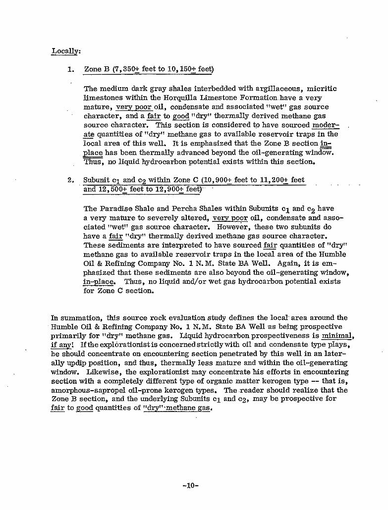
GEOTHERMAL DIAGENTIC CRITERIA ANTI VARIOUS GEOCHEMICAL RICHNESS SCALES UTILIZED FOR TABLE Vm DATA
KERMENTYPEYPREOOMW*NCEKEY
AI - AI881
GEOTHERMAL DIAGENETIC CRITERIA IUCau -,08IL,.IKI


FIGURE 1
HUMBLE No. 1 STATE BA HIDALGO COUNTY, NEW MEXICO
SUMMARY OF ORGANIC ANALYSES
SOURCE CHARACTER
QUATERNARY UIAVELS. .IC. 236
U-Bm FORHATIMI
LOWER CRETACE-
646'
UlhCHA LCHESTONE 956'
SCHERRER F " * T I ( I N . ' 1532'
EPITAPH W U m l T E
PERMIAN
EARP FORUATICU
PERMO-PENNSYLVANIAN W U I L L A LIMESTCUE
PARADISE FMATLTKW 11425'
MISSISSIPPIAN ESCABROSA UMESTOhE
DEVONIAN PERCHA SHALE 7
12500'
MONTOYA WUWlTE 12630'
13214' ORDOVICIAN
EL PAS0 FMlMATlOh
MISSISSIPPIAN
TOTAL DEPTH
14126
1 4 ~ 6 5 ESCABROSA LIMESTONE
LllhOYL00 OR, C A co
-.,.
5.EXTRACTION DATA . ^. VISUAL KEROGEN
I P 1 . , 1 1 4 ,

FI.GURE 2 */e P-N 0
4- EPITAPH DOLOMITE
4450' * -015
CoLlNA LIMESTONE
PERMIAN
EARP FORMATION
6265'
PERMO-PENNSYLVANIAN HOROUILLA LIMESTONE
9 -04Q
4f -043
1 0 9 9 5 ' ~ ~ ~
11425'
12500'
* -049
PARADISE FORMATION * -054
MISSISSIPPIAN ESCABROSA LIMESTONE 12
DEVONIAN * -062 PERCHA SHALE MONTOYA DOLOMITE 13
ORDOVICIAN 4 EL PAS0 FORMATION
MISSISSIPPIAN ESCABROSA LIMESTONE
TOTAL DEPTH 14585'
c
A
B
C
x
-No QUANTITATIVE DATA

17
19
FIG. 2 - B
1001 -015
22
23
I

FIG. 2 C
17
19
21
b
22
NAPHTHENES
-032
I
I
! i I I
i i
,
t
I
26

FIG 2 D
18
19
-035
\ MATURE CHARACTER
20

FIG 2 E
-..
- -038 19
17
a
,,
1 L
b
h
?O
21
n
22
23
24
NAPtiTHENES
26
I 27 I
J 28

NAPHTHENES
FIG. 2 F
-040
I i

-043
FIG. 2 G
NAPHTHENES
6
I/
27
a

-049
NAPHTHENES
FIG. 2 H
MA1 UKt CHARACTER
!

t
', 18
i
22
-054 23
b
NAPHTHENES
25

i
n I
16
FIG. 2 J
-06 2
20
21
22
23
NAPHTHENES

..... 1
-.
b
FIG. 2 K
-064
NAPHTHENES

-075
FIG. 2L
"
17
18
20
NAPHTHENES ! I
"
.-
-.
16
a
22
FIG. 2 M
Standard No. Denotes p C n Paraffin
a
b
= ip-clg = Isoprenoid Pristane
= ip-Cz0 = Isoprenoid Phytane
25

Figure 3
COMPANY Humble Oil Company GEOCHEM NO. 1001-49D NUMBER OF OBSERVATIONS 21
WELL OR OUTCROP LOCATION Hidalgo CO., N.M. DEPTH OR SAMPLE NO. m 5 0 ' - 10060'
MIN. REFLECTANCE 1-76 (?'OR.) MAX. REFLECTANCE 2.36 (%Ro) AVG. REFLECTANCE . 2 . 1 O . WoRo)
VlTRlNlTE REFLECTANCE HISTOGRAM