Sec. 16 Sec. 15 - Farmers NationalSec. 16 Sec. 15 Latitude: 42.6483°N Longitude: -98.7182°W...
4
31N 12W Sec. 21 Sec. 22 Sec. 16 Sec. 15 Latitude: 42.6483°N Longitude: -98.7182°W Imagery Source: USDA NAIP Maps Are For Visual Aid Only Boundaries Are Approximate L-1800070 Holt Co., NE
Transcript of Sec. 16 Sec. 15 - Farmers NationalSec. 16 Sec. 15 Latitude: 42.6483°N Longitude: -98.7182°W...

31N 12W
Sec. 21 Sec. 22
Sec. 16 Sec. 15
Latitude: 42.6483°NLongitude: -98.7182°WImagery Source: USDA NAIP Maps Are For Visual Aid OnlyBoundaries Are Approximate
L-1800070Holt Co., NE

3255
3183
3193
3183
3183
31N 12WSec. 21 Sec. 22
Sec. 16 Sec. 15
Latitude: 42.6483°NLongitude: -98.7182°WImagery Source: USDA NAIP Maps Are For Visual Aid OnlyBoundaries Are Approximate
L-1800070Holt Co., NE
MAP NON-IRR IRRSYMBOL SOIL NAME LCC LCC SRPG ACRES
3255 Meadin sandy loam, 2 to 30 percent slopes VIs --- 21 34.33183 Jansen loam, 0 to 2 percent slopes IIs IIs 52 0.43193 Jansen-Meadin loams, 2 to 6 percent slopes IIIe IIIe 47 0.2
SUMMARY 21.5 34.8
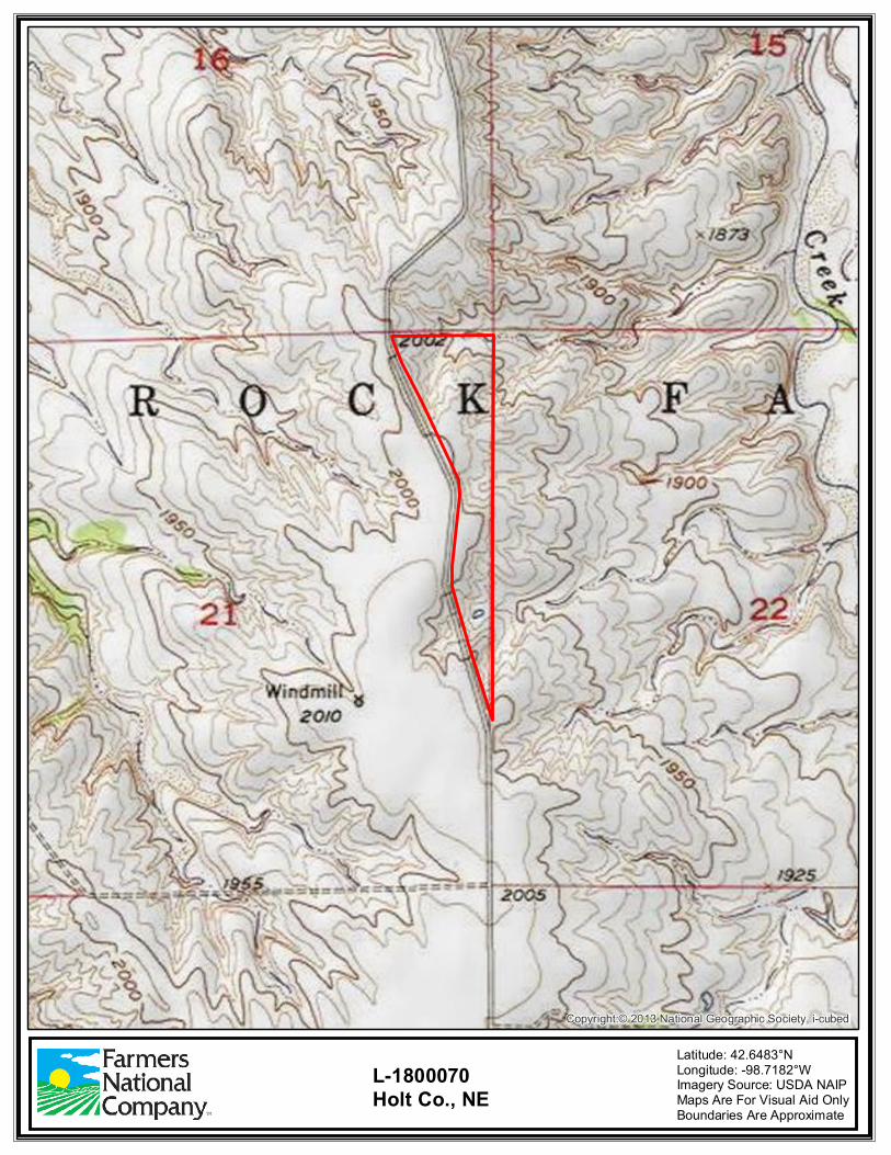
Copyright:© 2013 National Geographic Society, i-cubed
Latitude: 42.6483°NLongitude: -98.7182°WImagery Source: USDA NAIP Maps Are For Visual Aid OnlyBoundaries Are Approximate
L-1800070Holt Co., NE

E Douglas St
875th Rd
876th Rd
874th Rd
870th Rd
494 R
d
873rd Rd 496 R
d
495 R
d
490t
h Ave
493r
d Ave
492n
d Ave
487t
h Ave
493 R
d491s
t Ave
486t
h Ave
488t
h Ave
485t
h Ave
489t
h Ave
877th Rd
874 Rd
Oil Rd
872nd Rd
871st Rd
State Hwy 59
N7th
St
Old Hwy
7th St
1st S
t
Putte
r St
E Grant St Holt St
N 3rd St
870th Rd
871st Rd
485t
h Ave
488t
h Ave
Emmet
O'Neill
County Oil
281
20
281
Latitude: 42.5470°NLongitude: -98.7060°WImagery Source: USDA NAIP Maps Are For Visual Aid OnlyBoundaries Are Approximate
L-1800070Holt Co., NE