Seattle DPD - Shreline Environment Redesignation Maps ...pan/documents/web_informational/... · DPD...
19
Margaret Glowacki / Ketil Freeman Exhibit B DPD Shoreline Master Program Ord Exhibit B January 14, 2012 Version #3 Maps of Shoreline Environments Exhibit B to the DPD Shoreline Master Program Ordinance 1 2 3 4 5 6 7 8 9 10 11 12 13 14 15 16 17 18 1ST AVE S BROAD ST S ORCAS ST B A NNERWAYNE WALL ST E A S T L A K E A V EE SSPOKANEST BR O ADW A Y DENNY WAY 64TH AVE S N 80TH ST E YESLER WAY MADISON ST NW LEARY WAY MARION ST R O O S E V E L T W A Y N E SPRING ST CHERRY ST 9TH AVE N ELLIOTT AVE W 39TH A VE S 40TH AVE NE N 39TH ST SW ROXBURY ST N 85TH ST 6TH AVE RAINIER AVES E MADISON ST S GRAHAM ST NE 65TH ST 3R D A VE NW 17TH AVE NE BOREN AVE SBANGORST B E ACONAV ES 8TH AVE NW S MCCLELLAN ST 14TH AVE E PINE ST HARBORAVE SW 51ST AVE S 23RD AVE E 8TH AVE NE NW 65TH ST 4TH AVE S NE 125TH ST CONDONWAY W WEST VIEWMONT WAY W 2 2 N D AV E N E SW HENDERSON ST S MASSACHUSETTS ST 24TH AVE NW C ARKEEKDR S S ROXBURY ST NE 75TH ST S CLOVERDALE ST FUHRMAN AVE E 1 1 T H A V E N E GILMAN DR W W GALER ST NE NORTHGATE WAY AU ROR A AVE N EROY ST 1ST AVE S 34TH AVE W FAUNTLEROY WA Y S W MARIN E V IE W D R S W SENECA ST 35TH AVE NE S LUCILE ST E BO S TON ST NE 115TH ST NW 85TH ST E CHERRY ST E PIKE ST ELLIOTT AVE AURORA AVE N S ALBRO PL E THOMAS ST 35TH AVE SW S HENDERSON ST WATERS AVE S 2ND AVE SWSPOKANEST STONE WAY N N3 8 THST NE 55TH ST S MICHIGAN ST NE 95TH ST ELLIS AVE S 7TH AVE W 32ND AVE W 5 9 T H A V E S W 10TH AVE W 3RD AVE W COLUMBIA ST NW 125TH ST S DEARBORN ST SY LVAN W AYS W NW 96TH ST W G OV E R N M E N TWAY NE 45THST N 65TH ST HARVARD AVE E A I R P O R TW A YS W BERTONA ST SW HOLDEN ST HOWELL ST MAGNOLIA BR SHILSH OLEAVENW NE 80TH ST NE40TH S T S ALASKA ST 15 TH A V E N E WES T L A K EAV E W E ME R S ONP L EAST G R E ENL A KE DRN BEACON AVE S 3RD AVE N 45TH ST N 125TH ST NE 41ST ST 19TH AVE E MO N T LAKEBL V DNE E ASTGRE E NL A KE W A Y N SW BARTON ST 3RD AVE NW N 35TH ST N 34TH ST NW 46TH ST UNION ST 48T H AV E S W N PACIFI CST JAMES ST N 50TH ST BALLARD BR E JOHN ST M LK I N G J R W A Y FREMO N T AVEN CLI S E P L W 47TH AVE NE 15TH AVE S NNORT H G A TE W A Y NICKERSON ST WEST M ARGINAL WA Y SW E UNION ST SWIF TA V ES SWTHISTLEST NW MARKET ST SW JAC O B S EN R D 24TH AVE E 17TH AVE S 14TH AVE NW E JEFFERSON ST NW 80TH ST ERS K I N E W AY SW N 130TH ST CORSON AVE S FLORENTIA ST 12TH AVE NE 20TH AVE NW 8TH AVE 7TH AVE NE 6TH AVE S 15TH AVE NW NE 70TH ST W BARRETT ST L I N D E N A V EN DEL MA R D R E SW HANFORD ST ALASKAN WAY N 36TH ST EDENN Y W AY 1ST AVE W 30 T H A V E W LATONA AVE NE 55TH AVE SW SW ADMIRALWAY BR OADW A YE ML KIN GJR WAY S 31S T A V E S 15TH AVE N 40TH ST 34TH AVE BOSTON ST 5TH AVE S N 92ND ST SW MORGAN ST BELLEVUE AVE E 9TH AVE 7TH AVE YESLER WAY S GENESEE ST 14TH AVE S 1 0 T H A V E E VALLEY ST SW 106TH ST 5TH AVE N AURORA AVE N QUE E N A NNE A V E N REPUBLICAN ST H U B BE L L P L NE 110TH ST SW GRAHAM ST W EMERSON ST 19TH AVE 1ST AVE N MERCER ST ROY ST BATTERY ST BROOKLYN AVE NE LENORA ST W MERCER ST W OLYMPICPL SW GENESEE ST UNIVERSITY WAY NE E LYNN ST NE 145TH ST SW CHARLESTOWN ST W MCGRAW ST NW 100TH ST N 105TH ST 38TH AVE S MERIDIA N AV EN N56T HST N 90TH ST N 145TH ST LEARY AVE NW SW TRENTON ST 20TH A VE NE N 122ND ST W COMMODOREWAY ROOSEVELT WAY N N46TH ST W O O D L A N D P L N L AKESI D E AVES HOLMAN RD NW THACKERAY PL NE 32ND AVE E WNICKERSON ST LO Y AL WAYN W WALLINGFORD AVE N NE PACIFIC ST 50TH AVE S LEARY WAY NW 1ST AVE NE 6TH AVE W LA KE WA SH I N G TON B L VD CORLISS AVEN L I N D E N A V E N BOYLSTON AVE E 14TH AVE S WALLI NG FORD AVE N M A DRONA D R N W 54TH ST N NORTHLAK E WA Y 62ND AVE S OLS ONPLSW 15TH AVE NE 43RD AVE E 42ND AVE E S OTHELLO ST 16TH AVE SW MA G NOLIAB R WB 9TH AVE SW S CLOVERDALE ST C O L L E G E W A Y N DAYTON AVE N N 115TH ST 4 9 T H A V E SW SW 100TH ST 20TH AVE W 37TH AVE SW ALKI AVE SW THORNDYKE AVE W N 128TH ST 6 T H A V E N AIRPORT WAY S 16TH AVE SW MYERS WAY S 15TH AVE W WESTERN AVE 25TH AVE NE NE RAVENNABLVD WES T L A K E A V E N 4TH AVE SW AVAL O N W A Y RE NTONAVES CALIFORNIA AVE SW 5TH AVE NE DELRIDGE WAY SW WILSONAV E S FAIRVIEW AVE N 12TH AVE S 1ST AVE R A V ENNA A VENE 32ND AVE NW HIG HLA ND PARKW AY S W 28TH AVE NW 12TH AVE EASTMARGINALW AYS PHINNEY AVE N DEXTER AVE N LA KE C I T Y W A Y N E GREENWOOD AVE N 5TH AVE LA K E V I EW BL V D E 15TH AVE E BOYER AVE E 23RD AVE 2 3 R D A V E S BEACHDR S W LAKE WASHINGTON BLVD S TAYLOR AVE N 2 0 T H A VE S 2N D A VE SW S E WARDPARK AVE S MERIDIAN AVE N 8TH AVE S S A N D P O I N T W A Y NE H U N T E R B L V D S 28TH AVE W ALASKAN WAY S 1ST A V E S 1 2 T H A VE E 30TH AVE NE 6 T H A VE S 22ND AVE W GILMAN AVE W MAGNOLIA BLVDW 63RD AVE SW AURORA BR SEAVIEWAVENW Shoreline Environments Map B · 0 0.4 0.8 0.2 Miles No warranties of any sort, including accuracy, fitness, or merchantability accompany this product. Copyright 2013, All Rights Reserved, City of Seattle Prepared January 10, 2013 by DPD-GIS Legend Conservancy Management Conservancy Navigation Conservancy Preservation Conservancy Recreation Conservancy Waterway Urban Commercial Urban General Urban Harborfront Urban Industrial Urban Maritime Urban Residential Shoreline Exhibit B 1
Transcript of Seattle DPD - Shreline Environment Redesignation Maps ...pan/documents/web_informational/... · DPD...

Margaret Glowacki / Ketil Freeman Exhibit BDPD Shoreline Master Program Ord Exhibit BJanuary 14, 2012Version #3
Margaret GlowackiDPD Shoreline Master Program ORD Exhibit BAugust 24, 2012Version #2
Maps of Shoreline Environments Exhibit B to the DPD Shoreline Master Program Ordinance2
Exhibit B
NW 13 1ST S T
NW NORCROSS WAY
NW 13 0TH ST
12T
HA
VEN
W
NW 13 2ND ST
9TH AVEN
W
NW 13 7TH ST
NW 12 5TH ST
1 2TH
AVE NW
ME
R
R IL L
LNN
W
3RD
AV
EN
W
CU
L PEPER
CT
NW
N 110TH S T
N 1 07 TH ST
12TH
AVE
NW
NW 1 06 TH ST
N 1 45 TH S TNW 1 45TH S T
3RD
PL
NW
NW 11 0TH ST
6T
HAV
EN
W
N W WOOD BI NE WAY
NW 11 5TH ST
3RD
AV
EN
W
NW CULB ERTSON DR
NW 121 ST ST
8TH
AV
EN
W
N W 13 7TH PL
NW 10 7TH ST
NW 116 TH ST
NW 1 43 RD S T
NW 14 0TH ST
ALPINE
WA
YN
W
NW 117TH S T
NW 120 TH ST
NW 1 32 ND S T
NW 12 7TH ST
NW 12 2ND ST
NW 1 30 TH ST
NW 12 7TH STNW 12 7TH ST
NW 12 5TH ST
NW 12 0TH ST
VALM
AYAVE NW
FR
AZ
IER
PL
NW
1ST
AVE
NW
H ILLTO
P
L NN W
NW 119TH S T
NW11 4TH
ST
8 TH
A
V ENW
NW 114T H P L
NW 11 8TH S T
5TH
AV
EN
W
NW 118 TH ST
N W 117TH S T
9T H AVE NW
N W CA RK EEK PAR K RD
NW BLA KELY CT
NW 1 20TH S T
NW 12 2ND ST
NW 1 26 TH S T
2N DAVE
NW
NW 116TH S T
BLA KELY PL NW1
3T H
AVE NW
NW 11 3TH PL
NW 1 44 TH ST
S H E RM
AN
RD
NW
NO
RT
HS
HIR
ER
D
NW
13TH
AV
EN
W
8TH
AV
EN
W
NW PUG ET DR
1ST
AV
EN
W
11T
HAV
EN
W
10TH
AV
EN
W
4TH
AV
EN
W
8T
HAV
EN
W
3RD
AV
EN
W
2 ND
AV
EN
W
7 TH
AV
EN
W
4TH
AV
EN
W
3RD
AV
EN
W
6TH
AV
EN
W
ELD
OR
AD
OL
NN
W
2ND
AV
EN
W2
ND
AV
EN
W
4TH
AV
EN
W
2 ND
AV
EN
W
1S
TA
VE
NW
3R
DA
VE
NW
NW 1 36 TH ST
2N
DA
VE
NW
NW 13 5TH PL
3RD
AV
EN
W
4TH
AV
EN
W
6TH
AV
EN
W
7TH
AV
EN
W
9TH
AV
EN
W
8TH
AV
EN
W
10TH
AV
EN
W
9TH
AV
EN
W
4T
HAV
EN
W
15T
HA
VE
NW
14TH
AV
EN
W
NW 112 TH ST
BO U N DARY LN NW
O LYM P IC DR NW
11TH
AV
EN
W
N W SCEN IC DR
11
THAVE
NW
NORTHWOOD RD N W
SH ER WO OD RD NW
NW 116 TH ST
NW N ORTH WOO D R D
N W CHERRY LOOP
NWE LFORD DR
No warranties of any sort, including accuracy, fitness, or merchantability accompany this product.
Copyright June 22, 2012 All Rights Reserved, City of Seattle
MAP B
0 720 1,440360Feet¯
Proposed Shoreline Environments1
URCM
CN
CP
CR
CW
UC
UG
UH
UI
UM
Change from CN to CP
Shoreline
Shoreline EnvironmentsMAP B1Offi cial Land Use Map Pages 1 & 10
Change submerged lands from Conservancy Navigation to Conservancy Preservation.
1
2
3
4 56
78
9
10
11
1213
14
15
16
17
18
1ST
AVE
S
BROAD ST
S ORCAS ST
BANNER W
AY NE
WALL
ST
EA
ST L
AK
E A V
E E
S SPOKANE ST
BR
OA
DW
AY
DENNY WAY
64TH
AV
E S
N 80TH ST
E YESLER WAY
MADISON ST
NW LEARY WAY
MARION ST
RO
OS
EV
ELT
WAY
NE
SPRING ST
CHERRY ST
9TH
AV
E N
ELLIOTT AVE W
39TH
AV
E S
40TH
AV
E N
E
N 39TH ST
SW ROXBURY ST
N 85TH ST
6TH AVE
RAIN
IER AVE
S
E MADISON S
T
S GRAHAM ST
NE 65TH ST
3RD
AV
E N
W
17TH
AV
E N
E
BOREN AVE
S BANGOR ST
BE
AC
ON
AVE
S
8TH
AV
E N
W
S MCCLELLAN ST
14TH
AV
E
E PINE ST
HARBOR
AVE S
W
51S
T AV
E S
23R
D A
VE
E
8TH
AV
E N
E
NW 65TH ST
4TH
AV
E S
NE 125TH ST
CON
DO
N W
AY
W
WE
ST
VIE
WM
ON
T W
AY W
22N
D AV
E N
E
SW HENDERSON ST
S MASSACHUSETTS ST
24TH
AV
E N
W
CAR
KEEK
DR
S
S ROXBURY ST
NE 75TH ST
S CLOVERDALE ST
FUHRMAN AVE E
11TH
AVE
NE
GILM
AN DR
W
W GALER ST
NE NORTHGATE WAY
AU
RO
RA
AVE
N
E ROY ST
1ST
AVE
S
34TH
AV
E W
FAU
NTL
ERO
Y W
AY S
W
MARINE VIEW D
R S
W
SENECA ST
35TH
AV
E N
E
S LUCILE ST
E BOSTON ST
NE 115TH ST
NW 85TH ST
E CHERRY ST
E PIKE ST
ELLIOTT AVE
AU
RO
RA
AVE
N
S ALBRO PL
E THOMAS ST
35TH
AV
E S
W
S HENDERSON ST
WATERS AVE S
2ND AVE
SW SPOKANE ST
STO
NE
WAY
N
N 3 8TH ST
NE 55TH ST
S MICHIGAN ST
NE 95TH ST
ELLI
S A
VE
S
7TH
AV
E W
32N
D A
VE
W
5 9TH AV
E S
W
10TH
AV
E W
3RD
AV
E W
COLUMBIA ST
NW 125TH ST
S DEARBORN ST
SYLVAN
WAY SW
NW 96TH ST
W GOVER N
MENT WAY
NE 45TH ST
N 65TH ST
HA
RVA
RD
AV
E E
AIR
PO
RT
WAY
S
W BERTONA ST
SW HOLDEN ST
HOWELL
ST
MAGNOLIA BR
SHILSHOLE AVE
NW
NE 80TH ST
NE 40TH ST
S ALASKA ST
15TH
AVE
NE
WE
STLA
KE
AVE
W EMERSON PL
EAST G
RE EN LAKE DR N
BEACON AVE S
3RD AVE
N 45TH ST
N 125TH ST
NE 41ST ST
19TH
AV
E E
MO
NTL
AKE
BLV
D N
E
E AST GREEN
LAK
E W
AY N
SW BARTON ST
3RD
AV
E N
W
N 35TH STN 34TH ST
NW 46TH ST
UNION ST
48TH
AVE
SW
N PACIF
IC ST
JAMES ST
N 50TH ST
BA
LLA
RD
BR
E JOHN ST
M L
KIN
G J R
WAY
FRE
MO
NT
AVE
N
CLISE P
L W
47TH
AV
E N
E
15TH
AV
E S
N NORTH GATE W
AY
NICKERSON ST
WEST
MA
RG
INA
L W
AY S
W
E UNION ST
SWIFT
AVE S
SW THISTLE ST
NW MARKET ST
SW JACOBSEN
RD
24TH
AV
E E
17TH
AV
E S
14TH
AV
E N
W
E JEFFERSON ST
NW 80TH ST
ERSKINE
W
AY SW
N 130TH ST
CO
RSO
N A
VE S
FLORENTIA ST
12TH
AV
E N
E
20TH
AV
E N
W
8TH AVE
7TH
AV
E N
E
6TH
AV
E S
15TH
AV
E N
W
NE 70TH ST
W BARRETT ST
LIN
DE
N A V
E N
DELMAR DR E
SW HANFORD ST
ALASKAN WAY
N 36TH ST
E DENNY WAY
1ST
AVE
W
30TH AV
E W
LATO
NA
AVE
NE
55TH
AV
E S
W
SW
ADMIRAL WAY
BR
OA
DW
AY E
M L
KING
JR W
AY S
31S
T AV
E S
15TH
AV
E
N 40TH ST
34TH
AV
E
BOSTON ST
5TH
AV
E S
N 92ND ST
SW MORGAN ST
BE
LLE
VU
E A
VE
E
9TH AVE
7TH AVE
YESLER WAY
S GENESEE ST
14TH
AV
E S
1 0T H
A VE
E
VALLEY ST
SW 106TH ST
5TH
AV
E N
AU
RO
RA
AVE
N
QU
EE
N A
NN
E AV
E N
REPUBLICAN ST
HU
BBEL
L P
L
NE 110TH ST
SW GRAHAM ST
W EMERSON ST
19TH
AV
E
1ST
AVE
N
MERCER STROY ST
BATTERY S
T
BR
OO
KLY
N A
VE
NE
LENORA S
TW MERCER ST
W OLYMPIC PL
SW GENESEE ST
UN
IVE
RS
ITY
WAY
NE
E LYNN ST
NE 145TH ST
SW CHARLESTOWN ST
W MCGRAW ST
NW 100TH ST
N 105TH ST
38TH
AV
E S
ME
RID
IAN
AV
E N
N 56TH ST
N 90TH ST
N 145TH ST
LEARY AVE NW
SW TRENTON ST
20TH
AV
E N
E
N 122ND ST
W COMMODORE WAY
ROOSEVELT WAY N
N 46TH ST
WOODLA
ND
PL N
LAK
ES
IDE
AVE S
HOLMAN RD NW
THA
CK
ER
AY P
L N
E
32N
D A
VE
E
W NICKERSON
ST
LOYAL
WAY NW
WA
LLIN
GFO
RD
AV
E N
NE PACIFIC ST
50TH
AV
E S
LEARY WAY NW
1ST
AVE
NE
6TH
AV
E W
LAK
E W
AS
HIN
GTO
N B
LVD
CORLISS
AVE N
LIN
DE
N AV
E N
BO
YLS
TON
AV
E E
14TH
AV
E S
WA
LLIN
GFO
RD
AV
E N
MA
DR
ONA
DR
NW 54TH ST
N
NORT
HLAK
E W
AY
62N
D A
VE
S
OLS
ON PL SW
15TH
AV
E N
E
43R
D A
VE
E42
ND
AV
E E
S OTHELLO ST
16TH
AV
E S
W
MAGNOLIA BR WB
9TH
AV
E S
W
S CLOVERDALE ST
CO
L LE
GE
WA Y
N
DAY
TON
AV
E N
N 115TH ST
49TH
AVE
SW
SW 100TH ST
20TH
AV
E W
37TH
AV
E S
W
ALKI A
VE SW
THO
RND
YKE
AVE
W
N 128TH ST
6TH AVE
N
AIRPO
RT W
AY S
16TH
AV
E S
W
MYER
S WAY S
15TH
AV
E W
WESTERN AVE
25TH
AV
E N
ENE
RAVENNA BLVD
WESTLAK
E AV
E N
4TH AVE
SW AV
ALO
N W
AY
RENTON AVE
S
CA
LIFO
RN
IA A
VE
SW
5TH
AV
E N
E
DE
LRID
GE
WAY
SW
WILSON
AVE S
FAIR
VIEW
AVE N
12TH
AV
E S
1ST AVE
RAVENNA
AVE
NE
32N
D A
VE
NW
HIGHLAND PARK WAY SW
28TH
AV
E N
W
12TH
AV
E
EAST MARGINAL WAY S
PH
INN
EY
AV
E N
DE
XTE
R A
VE
N
LAKE
CIT
Y W
A Y N
E
GR
EE
NW
OO
D A
VE
N
5TH AVE
LAK
EVI
EW B
LVD
E
15TH
AV
E E
BOYER AVE E
23R
D A
VE
2 3R
D AV
E S
BEACH
DR
SW
LAKE W
ASHIN
GTO
N B
LVD S
TAY
LOR
AV
E N
20TH
AVE
S
2ND
AV
E S
W
SEWAR
D PARK
AVE S
ME
RID
IAN
AV
E N
8TH
AVE
S
SA
ND
PO
INT
WAY
NE
HU
NT
E R B
LVD
S
28TH
AV
E W
ALA
SK
AN
WAY
S
1ST
AVE
S
12TH
AVE
E
30TH
AV
E N
E
6TH AV
E S
22N
D A
VE
W
GILMAN AVE W
MAGNOLIA
BLVD W
63R
D A
VE
SW
AU
RO
RA
BR
SEAV
IEW
AVE
NW
Shoreline Environments
Map B
·0 0.4 0.80.2
Miles
No warranties of any sort, including accuracy, fitness, or merchantability accompany this product.
Copyright 2013, All Rights Reserved, City of Seattle Prepared January 10, 2013 by DPD-GIS
LegendConservancy Management
Conservancy Navigation
Conservancy Preservation
Conservancy Recreation
Conservancy Waterway
Urban Commercial
Urban General
Urban Harborfront
Urban Industrial
Urban Maritime
Urban Residential
Shoreline
Margaret GlowackiDPD Shoreline Master Program ORD Exhibit BAugust 24, 2012Version #2
Maps of Shoreline Environments Exhibit B to the DPD Shoreline Master Program Ordinance2
Exhibit B
NW 13 1ST S T
NW NORCROSS WAY
NW 13 0TH ST
12T
HA
VEN
W
NW 13 2ND ST
9TH AVEN
W
NW 13 7TH ST
NW 12 5TH ST
1 2TH
AVE NW
ME
R
R IL L
LNN
W
3RD
AV
EN
W
CU
L PEPER
CT
NW
N 110TH S T
N 1 07 TH ST
12TH
AVE
NW
NW 1 06 TH ST
N 1 45 TH S TNW 1 45TH S T
3RD
PL
NW
NW 11 0TH ST
6T
HAV
EN
W
N W WOOD BI NE WAY
NW 11 5TH ST
3RD
AV
EN
W
NW CULB ERTSON DR
NW 121 ST ST
8TH
AV
EN
W
N W 13 7TH PL
NW 10 7TH ST
NW 116 TH ST
NW 1 43 RD S T
NW 14 0TH ST
ALPINE
WA
YN
W
NW 117TH S T
NW 120 TH ST
NW 1 32 ND S T
NW 12 7TH ST
NW 12 2ND ST
NW 1 30 TH ST
NW 12 7TH STNW 12 7TH ST
NW 12 5TH ST
NW 12 0TH ST
VALM
AYAVE NW
FR
AZ
IER
PL
NW
1ST
AVE
NW
H ILLTO
P
L NN W
NW 119TH S T
NW11 4TH
ST
8 TH
A
V ENW
NW 114T H P L
NW 11 8TH S T
5TH
AV
EN
W
NW 118 TH ST
N W 117TH S T
9T H AVE NW
N W CA RK EEK PAR K RD
NW BLA KELY CT
NW 1 20TH S T
NW 12 2ND ST
NW 1 26 TH S T
2N DAVE
NW
NW 116TH S T
BLA KELY PL NW1
3T H
AVE NW
NW 11 3TH PL
NW 1 44 TH ST
S H E RM
AN
RD
NW
NO
RT
HS
HIR
ER
D
NW
13TH
AV
EN
W
8TH
AV
EN
W
NW PUG ET DR
1ST
AV
EN
W
11T
HAV
EN
W
10TH
AV
EN
W
4TH
AV
EN
W
8T
HAV
EN
W
3RD
AV
EN
W
2 ND
AV
EN
W
7 TH
AV
EN
W
4TH
AV
EN
W
3RD
AV
EN
W
6TH
AV
EN
W
ELD
OR
AD
OL
NN
W
2ND
AV
EN
W2
ND
AV
EN
W
4TH
AV
EN
W
2 ND
AV
EN
W
1S
TA
VE
NW
3R
DA
VE
NW
NW 1 36 TH ST
2N
DA
VE
NW
NW 13 5TH PL
3RD
AV
EN
W
4TH
AV
EN
W
6TH
AV
EN
W
7TH
AV
EN
W
9TH
AV
EN
W
8TH
AV
EN
W
10TH
AV
EN
W
9TH
AV
EN
W
4T
HAV
EN
W
15T
HA
VE
NW
14TH
AV
EN
W
NW 112 TH ST
BO U N DARY LN NW
O LYM P IC DR NW
11TH
AV
EN
W
N W SCEN IC DR
11
THAVE
NW
NORTHWOOD RD N W
SH ER WO OD RD NW
NW 116 TH ST
NW N ORTH WOO D R D
N W CHERRY LOOP
NWE LFORD DR
No warranties of any sort, including accuracy, fitness, or merchantability accompany this product.
Copyright June 22, 2012 All Rights Reserved, City of Seattle
MAP B
0 720 1,440360Feet¯
Proposed Shoreline Environments1
URCM
CN
CP
CR
CW
UC
UG
UH
UI
UM
Change from CN to CP
Shoreline
Shoreline EnvironmentsMAP B1Offi cial Land Use Map Pages 1 & 10
Change submerged lands from Conservancy Navigation to Conservancy Preservation.
1

Margaret GlowackiDPD Shoreline Master Program ORD Exhibit BAugust 24, 2012Version #2
Maps of Shoreline Environments Exhibit B to the DPD Shoreline Master Program Ordinance2
Exhibit B
NW 13 1ST S T
NW NORCROSS WAY
NW 13 0TH ST
12T
HA
VEN
W
NW 13 2ND ST
9TH AVEN
W
NW 13 7TH ST
NW 12 5TH ST
1 2TH
AVE NW
ME
R
R IL L
LNN
W
3RD
AV
EN
W
CU
L PEPER
CT
NW
N 110TH S T
N 1 07 TH ST
12TH
AVE
NW
NW 1 06 TH ST
N 1 45 TH S TNW 1 45TH S T
3RD
PL
NW
NW 11 0TH ST
6T
HAV
EN
W
N W WOOD BI NE WAY
NW 11 5TH ST
3RD
AV
EN
W
NW CULB ERTSON DR
NW 121 ST ST
8TH
AV
EN
W
N W 13 7TH PL
NW 10 7TH ST
NW 116 TH ST
NW 1 43 RD S T
NW 14 0TH ST
ALPINE
WA
YN
W
NW 117TH S T
NW 120 TH ST
NW 1 32 ND S T
NW 12 7TH ST
NW 12 2ND ST
NW 1 30 TH ST
NW 12 7TH STNW 12 7TH ST
NW 12 5TH ST
NW 12 0TH ST
VALM
AYAVE NW
FR
AZ
IER
PL
NW
1ST
AVE
NW
H ILLTO
P
L NN W
NW 119TH S T
NW11 4TH
ST
8 TH
A
V ENW
NW 114T H P L
NW 11 8TH S T
5TH
AV
EN
W
NW 118 TH ST
N W 117TH S T
9T H AVE NW
N W CA RK EEK PAR K RD
NW BLA KELY CT
NW 1 20TH S T
NW 12 2ND ST
NW 1 26 TH S T
2N DAVE
NW
NW 116TH S T
BLA KELY PL NW1
3T H
AVE NW
NW 11 3TH PL
NW 1 44 TH ST
S H E RM
AN
RD
NW
NO
RT
HS
HIR
ER
D
NW
13TH
AV
EN
W
8TH
AV
EN
W
NW PUG ET DR
1ST
AV
EN
W
11T
HAV
EN
W
10TH
AV
EN
W
4TH
AV
EN
W
8T
HAV
EN
W
3RD
AV
EN
W
2 ND
AV
EN
W
7 TH
AV
EN
W
4TH
AV
EN
W
3RD
AV
EN
W
6TH
AV
EN
W
ELD
OR
AD
OL
NN
W
2ND
AV
EN
W2
ND
AV
EN
W
4TH
AV
EN
W
2 ND
AV
EN
W
1S
TA
VE
NW
3R
DA
VE
NW
NW 1 36 TH ST
2N
DA
VE
NW
NW 13 5TH PL
3RD
AV
EN
W
4TH
AV
EN
W
6TH
AV
EN
W
7TH
AV
EN
W
9TH
AV
EN
W
8TH
AV
EN
W
10TH
AV
EN
W
9TH
AV
EN
W
4T
HAV
EN
W
15T
HA
VE
NW
14TH
AV
EN
W
NW 112 TH ST
BO U N DARY LN NW
O LYM P IC DR NW
11TH
AV
EN
W
N W SCEN IC DR
11
THAVE
NW
NORTHWOOD RD N W
SH ER WO OD RD NW
NW 116 TH ST
NW N ORTH WOO D R D
N W CHERRY LOOP
NWE LFORD DR
No warranties of any sort, including accuracy, fitness, or merchantability accompany this product.
Copyright June 22, 2012 All Rights Reserved, City of Seattle
MAP B
0 720 1,440360Feet¯
Proposed Shoreline Environments1
URCM
CN
CP
CR
CW
UC
UG
UH
UI
UM
Change from CN to CP
Shoreline
Shoreline EnvironmentsMAP B1Offi cial Land Use Map Pages 1 & 10
Change submerged lands from Conservancy Navigation to Conservancy Preservation.
Margaret Glowacki / Ketil Freeman Exhibit BDPD Shoreline Master Program Ord Exhibit BJanuary 14, 2012Version #3

Margaret GlowackiDPD Shoreline Master Program ORD Exhibit BAugust 24, 2012Version #2
Maps of Shoreline Environments Exhibit B to the DPD Shoreline Master Program Ordinance3
Exhibit B
12TH
AVE
NW
NW WOODBINE WAY
NW 119TH ST
NW 118TH ST
NW 120TH ST
NW 117TH ST
NW 116TH ST
NW NORCROSS WAY
NW CARKEEK PARK RD
No warranties of any sort, including accuracy, fitness, or merchantability accompany this product.
Copyright June 22, 2012 All Rights Reserved, City of Seattle
MAP B
0 210 420105Feet¯
Proposed Shoreline Environments2
URCM
CN
CP
CR
CW
UC
UG
UH
UI
UM
Change to CR
Shoreline
Shoreline EnvironmentsMAP B2Offi cial Land Use Map Page 10
Extend Shoreline District to include associated wetlands and designate this area Conservancy Preservation.
Margaret Glowacki / Ketil Freeman Exhibit BDPD Shoreline Master Program Ord Exhibit BJanuary 14, 2012Version #3

Margaret GlowackiDPD Shoreline Master Program ORD Exhibit BAugust 24, 2012Version #2
Maps of Shoreline Environments Exhibit B to the DPD Shoreline Master Program Ordinance4
Exhibit B
GILMAN AVE W
29TH
AVE
W
W GOVERNMENT WAY
W FORT ST
W JAMESON ST
WHARLEY ST
28TH
A VE
W
33R
DAV
EW
28TH
PL
W
3 1S
TAV
EW
3 0T H
AVE
W
32N
DAV
EW
GA Y
AV
E W W COMMODORE WAY
No warranties of any sort, including accuracy, fitness, or merchantability accompany this product.
Copyright June 22, 2012 All Rights Reserved, City of Seattle
MAP B
0 150 30075Feet¯
Proposed Shoreline Environments3
URCM
CN
CP
CR
CW
UC
UG
UH
UI
UM
Change from US to UC
Shoreline
Shoreline EnvironmentsMAP B3Offi cial Land Use Map Pages 52 & 53
Change from Urban Residential to Urban Maritime.
Margaret Glowacki / Ketil Freeman Exhibit BDPD Shoreline Master Program Ord Exhibit BJanuary 14, 2012Version #3
Margaret GlowackiDPD Shoreline Master Program ORD Exhibit BAugust 24, 2012Version #2
Maps of Shoreline Environments Exhibit B to the DPD Shoreline Master Program Ordinance5
Exhibit B
BRIDGE WAY N
N 34TH ST
N 39TH ST
5THAV
EW
HALLADAY ST
1ST
A VE
N
4 TH
AVE
W
QU
EE
NA
NN
EAV
EN
W BERTONA ST
FULTON ST
NW 36TH ST
N 41ST ST
LEARYW
AYNW
NW 39TH ST
W FLORENTIA ST
N 38TH ST
FRE
MO
NT
BR
N 39TH ST
N 36TH ST
FRE
MO
NT
AVE
N
3RD
AVE
NW
N NORTHLAKE WAY
3RD
AVE
W
DEXTER AVE N
BIR
CH
AVE
N
5THAV
EN
4 TH
AVE
N4 T
HA V
EN
N 36TH ST
NEWELL ST
AU
RO
RA
AVE
N
QUEEN ANNE DR
1ST
AV
EW
QU
EE
NA
NN
EA V
EN
3RD
A VE
W
6TH
AVE
NW
3RD
AV
EW
W ARMOUR ST
W FULTON ST
W NEWELL ST
W RAYE ST
W BARRETT ST
W FULTON ST
W ARMOUR ST
W HALLADAY ST
RAYE ST
W NEWELL ST
ARMOUR ST
FULTON ST
NEWELL ST
TRO
LLA
VE
N
N 40TH ST
FREMONT
WAY
NN 41ST ST
PH
INN
EY
A VE
N
NICKERSON ST
DAY
TON
AVE
N EV A
NS
T ON
A VE
N
CREMONA ST
RAYE ST
NWCANAL ST
LIN
DE
NA V
EN
FLORENTIA ST
N 40TH ST
W NICKERSON ST
1ST
AVE
NW
4TH
A VE
W
NO
BH
ILL
AVE
N
1 ST
AV
EN
W
P ALA TIN
EAV
EN
GR
EE
NW
OO
DAV
EN
PH
INN
EY
AVE
N
NW 40TH ST AU
RO
RA
AV
EN
WH
ITM
AN
AVE
N
WO
OD
LAN
DPA
RK
AV
EN
BAK
ER
AVE
NW
N BOWDOIN PL
MA
YFA
IRA V
EN
3RD
A VE
N
NW 41ST ST
2ND
AVE
NW
WESTLAKE EAST RDWY AVE N
WH
I TM
AN
AVE
N
WIN
SLO
WP
LN
AU
RO
RA
A VE
N
PAL A
TIN
EAV
EN
WA
RR
EN
AVE
N
2ND
AVE
N
MAYFAIR AVE N
FREMONTPL N
WESTLAKE AVE N
LIN
DE
NA
VE
N
6TH AVE N
HUMESPL
W
DRAVUS ST
FRE
MO
NT
AVE
N
NW BOWDOIN PL
2 ND
AV
EW
N 35TH ST
W ETRURIA ST
FRA
NC
ISA V
EN
ALB
ION
PL
N
ETRURIA ST
WO
OD
LAN
DPA
RK
A VE
N
W CREMONA ST
W DRAVUS ST
W EWING ST
N 34TH ST
N 35TH ST
DAY
T ON
AVE
N
AU
RO
RA
BR
N CANAL ST
EVA
NS
TON
AV
EN
No warranties of any sort, including accuracy, fitness, or merchantability accompany this product.
Copyright June 22, 2012 All Rights Reserved, City of Seattle
MAP B
0 370 740185Feet¯
Proposed Shoreline Environments4
URCM
CN
CP
CR
CW
UC
UG
UH
UI
UM
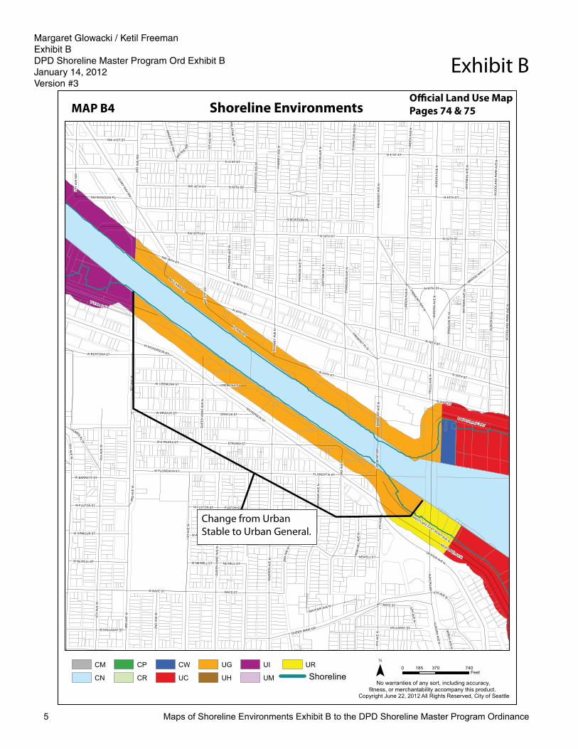
Change from UG to US
Shoreline
Shoreline EnvironmentsMAP B4Offi cial Land Use Map Pages 74 & 75
Change from Urban Stable to Urban General.
Margaret Glowacki / Ketil Freeman Exhibit BDPD Shoreline Master Program Ord Exhibit BJanuary 14, 2012Version #3

Margaret GlowackiDPD Shoreline Master Program ORD Exhibit BAugust 24, 2012Version #2
Maps of Shoreline Environments Exhibit B to the DPD Shoreline Master Program Ordinance6
Exhibit B
2 7TH
A VE
NE
40TH
A VE
NE
PE
ND OREILLERD NE
SUR
BERD
RN
E
NE 41ST ST
NE 38TH ST
MON
TLAK
EBL
VD
NE
NE
40TH ST
NE 44TH ST
NE 43RD ST
NE 44TH ST
NE 42ND ST
NE 45TH ST
NE BLAKELEY ST
37TH
AVE
NE
NE45
TH
STRP
36TH
AVE
NE
4 0TH
A VE
NE
38TH
AVE
NE
NE WALLA WALLA RD
NE CLARK RD
MARY
GATES
MEM
ORIAL
DR
NE
SAND POINT WAY NE
NE 45TH PL
39TH AVE NE
NE CANAL RD
25TH
AVE
NE
FRAN
KLINP L
NE
P EN
D
O REILLEPL
NE
CANAL RDN
E
WAL
LAW
ALLA
RD
NE
NE SURBER DRNE WAHKIAKUM LN
NE BELVOIR PL
WALLA WALLA RDNE
WAL
LAW
ALLA
RDNE
DOUG
LAS
RDNE
No warranties of any sort, including accuracy, fitness, or merchantability accompany this product.
Copyright June 22, 2012 All Rights Reserved, City of Seattle
MAP B
0 330 660165Feet¯
Proposed Shoreline Environments5
URCM
CN
CP
CR
CW
UC
UG
UH
UI
UM
Change from CP to CR
Shoreline
Shoreline EnvironmentsMAP B5Offi cial Land Use Map Pages 80 & 81
Extend Shoreline District to include associated wetlands and designate this area Conservancy Preservation.
Margaret Glowacki / Ketil Freeman Exhibit BDPD Shoreline Master Program Ord Exhibit BJanuary 14, 2012Version #3

Margaret GlowackiDPD Shoreline Master Program ORD Exhibit BAugust 24, 2012Version #2
Maps of Shoreline Environments Exhibit B to the DPD Shoreline Master Program Ordinance7
Exhibit B
50THAVE
NE
NE 39TH ST
NE 40TH ST
NE 41ST ST
NE 36TH ST
48TH
PL
NE
47TH PL NE
NE LAURELCRESTLN
49THAVE
NE
48THAVE
NE
NE LATIMER PL
51STAVE
NE
NE LAURELCREST LN
No warranties of any sort, including accuracy, fitness, or merchantability accompany this product.
Copyright June 22, 2012 All Rights Reserved, City of Seattle
MAP B
0 140 28070Feet¯
Proposed Shoreline Environments6
URCM
CN
CP
CR
CW
UC
UG
UH
UI
UM
Change from CM to CR
Shoreline
Shoreline EnvironmentsMAP B6 Offi cial Land Use Map Page 82
Change dry and submerged land from Conservancy Management to Conservancy Recreation.
Margaret Glowacki / Ketil Freeman Exhibit BDPD Shoreline Master Program Ord Exhibit BJanuary 14, 2012Version #3

Margaret GlowackiDPD Shoreline Master Program ORD Exhibit BAugust 24, 2012Version #2
Maps of Shoreline Environments Exhibit B to the DPD Shoreline Master Program Ordinance8
Exhibit BW
EST
LAUR
ELDR
NE
55TH
AVE
NE
53RDAV
EN
E
NE PENRITH RD
NE WINDERMERE RD
60THA
VEN
E
NE 50TH ST
NE 54TH ST
NE 45TH ST
HAROLDPL NE
54TH
AVE
NE
N E KELDENPL
ELL
ER
AYL N
NE
KENILWORTH
PL
NE
EA
ST
LAU
REL
DR
NE
55TH
A VE
NE
NE AMBLESIDE RD
52N
DAV
EN
E
NE 55TH ST
NE KESWICK DR
IVANHOEPL NE
No warranties of any sort, including accuracy, fitness, or merchantability accompany this product.
Copyright June 22, 2012 All Rights Reserved, City of Seattle
MAP B
0 180 36090Feet¯
Proposed Shoreline Environments7
URCM
CN
CP
CR
CW
UC
UG
UH
UI
UM
Change from CM to CR
Shoreline
Shoreline EnvironmentsMAP B7Offi cial Land Use Map Page 65
Change dry land from Conservancy Management to Conservancy Recreation.
Margaret Glowacki / Ketil Freeman Exhibit BDPD Shoreline Master Program Ord Exhibit BJanuary 14, 2012Version #3

Margaret GlowackiDPD Shoreline Master Program ORD Exhibit BAugust 24, 2012Version #2
Maps of Shoreline Environments Exhibit B to the DPD Shoreline Master Program Ordinance9
Exhibit BNE
WIN
DERM
ERE
RD
NE 60TH ST
NE 65TH ST
LAKE SHORE DR NE
No warranties of any sort, including accuracy, fitness, or merchantability accompany this product.
Copyright June 22, 2012 All Rights Reserved, City of Seattle
MAP B
0 230 460115Feet¯
Proposed Shoreline Environments8
URCM
CN
CP
CR
CW
UC
UG
UH
UI
UM
Change from CM to CP
Shoreline
Shoreline EnvironmentsMAP B8Offi cial Land Use Map Page 49
Change dry and submerged land from Conservancy Management to Conservancy Recreation.
Margaret Glowacki / Ketil Freeman Exhibit BDPD Shoreline Master Program Ord Exhibit BJanuary 14, 2012Version #3
Margaret Glowacki / Ketil Freeman Exhibit BDPD Shoreline Master Program Ord Exhibit BJanuary 14, 2012Version #3

Margaret GlowackiDPD Shoreline Master Program ORD Exhibit BAugust 24, 2012Version #2
Maps of Shoreline Environments Exhibit B to the DPD Shoreline Master Program Ordinance10
Exhibit B
NE 74TH ST
NE 77TH ST
NE NOAA DR
63R
DAV
EN
E
LAKE SHOREDR
NE
62N
DA V
EN
E
SPO
RTSFIELD DR
NE
No warranties of any sort, including accuracy, fitness, or merchantability accompany this product.
Copyright August 24, 2012 All Rights Reserved, City of Seattle
MAP A
0 425 850212.5Feet¯
Shoreline Environments9
URCM
CN
CP
CR
CW
UC
UG
UH
UI
UM
Change from CM to CR
Shoreline
Shoreline EnvironmentsMAP B9Offi cial Land Use Map Page 49
Change submerged land from Conservancy Management to Conservancy Preservation.
Margaret Glowacki / Ketil Freeman Exhibit BDPD Shoreline Master Program Ord Exhibit BJanuary 14, 2012Version #3

Margaret GlowackiDPD Shoreline Master Program ORD Exhibit BAugust 24, 2012Version #2
Maps of Shoreline Environments Exhibit B to the DPD Shoreline Master Program Ordinance11
Exhibit B
51STAVE
NE
NE 90THPL
SA
ND
POIN
TW
A YN
E
46TH
AVE
NE
53RDAVE
NE
NE 89TH ST
49TH AVE NE
NE 88TH ST
NE 97TH ST
53RD
CT
NE
MATTHEWSPL NE
NE 92ND ST
NE 100TH ST
55THAVE
NE
PAISLE
YPL
NE
NE 87TH ST
NE 93RD ST
NE 97TH ST
NE 94TH ST
INVERNESS DR NE
NE 95TH ST
NE 86TH ST
54TH AVENE
NE 88TH PL
49T
HAV
EN
E
NE 85TH ST
48T H
A VE
NE
LAKE
SHOREBL
VDNE
PAISLEY DR NE
MATTHEWS AVE NE
SAND POINT WAY NE
No warranties of any sort, including accuracy, fitness, or merchantability accompany this product.
Copyright August 24, 2012 All Rights Reserved, City of Seattle
MAP A
0 280 560140Feet¯
Shoreline Environments10
URCM
CN
CP
CR
CW
UC
UG
UH
UI
UM
Change from CR to CP
Shoreline
Shoreline EnvironmentsMAP B10 Offi cial Land Use Map Pages 33 & 210
Change dry and submerged land from Conservancy Recreation to Conservancy Preservation.
Margaret Glowacki / Ketil Freeman Exhibit BDPD Shoreline Master Program Ord Exhibit BJanuary 14, 2012Version #3

Margaret GlowackiDPD Shoreline Master Program ORD Exhibit BAugust 24, 2012Version #2
Maps of Shoreline Environments Exhibit B to the DPD Shoreline Master Program Ordinance12
Exhibit B
W GARFIELD ST
3 9TH
A VE
W
W HOWE ST
W CLISE CT
38TH
AVE
W
WESTMONT WAY W
40TH
A VE
W
36TH
AVE
W
W MCGRAW ST
W LYNN ST
W MCGRAW ST
32N
DA V
EW
35TH
AVEW
CLISEPL
W
34TH
AVE
W
W BLAINE ST
34THCT W
W HAYES ST
36TH
AVE
W
MONTVALE
PL
W
WE
STV
IEW
MO
NT
WAY
W
W RAYE ST
W WHEELER ST
WEST
VIEWMONT WAY W
W RAYE ST
WPA
RKM
ON
TP
L
W SMITH ST
MONTVALECT W
W MONTFORT PL
WO
LFE
PLW
CONSTANCEDR
W
COND
ON
WAY
W
EASTMONT WAY W
CRESTMONT PL W
33RD
AV EW
PERKINS LN W
ROSEMONT PL W
CONSTA NCE DR W
EYRES
PL W
MOUNTAIND R W
WRAYE ST
VIEW MONT WAY
W
W BLAINE ST
CRANEDR
W
43RDAVE
W42ND
AVEW
MORLEY PL W
MONTAVISTA PL W
P IED
MO
NT
P LW
34T HAV E
W
31 ST
AVEW
35TH
AVE
W
31S
TAV
EW
W GALER ST
ELLINOR DRW
MAGNOLIA BLVD W
EDGEMONT PL W
ALTAVIS
TA PL W
37TH
AVE W
MAGNOLIA BLVD W
CONSTANCE DRW
32N
DAV
EW
No warranties of any sort, including accuracy, fitness, or merchantability accompany this product.
Copyright June 22, 2012 All Rights Reserved, City of Seattle
MAP B
0 450 900225Feet¯
Proposed Shoreline Environments11
URCM
CN
CP
CR
CW
UC
UG
UH
UI
UM
Change from CR to CP
Shoreline
Shoreline EnvironmentsMAP B11 Offi cial Land Use Map Pages 83 & 84
Change submerged land from Conservancy Recreation to Conservancy Preservation.
Margaret Glowacki / Ketil Freeman Exhibit BDPD Shoreline Master Program Ord Exhibit BJanuary 14, 2012Version #3

Margaret GlowackiDPD Shoreline Master Program ORD Exhibit BAugust 24, 2012Version #2
Maps of Shoreline Environments Exhibit B to the DPD Shoreline Master Program Ordinance13
Exhibit B
W GARFIELD ST
23R
DA V
EW
CO
NDON WAY W
28T H
AVE
WW EATON ST
W BLAINE ST 27TH
AVE
W
W GALER ST
31S
TAV
EW
3 0TH
AVE
W
29TH
AVE
W
W HAYES ST
W GARFIELD ST ON RP
W GARFIELD ST OFF RP
W GALER STTH
O RNDYKE
AVE
W
MAGNOLIA BLVD W MAGNOLIA
WAY
W
MAGNOLIA BR
W MARINA PARKING PL
W MARINA PL
No warranties of any sort, including accuracy, fitness, or merchantability accompany this product.
Copyright June 22, 2012 All Rights Reserved, City of Seattle
MAP B
0 250 500125Feet¯
Proposed Shoreline Environments12
URCM
CN
CP
CR
CW
UC
UG
UH
UI
UM
Change from UR to UM
Shoreline
Shoreline EnvironmentsMAP B12 Offi cial Land Use Map Pages 97 & 214
Change dry land from Urban Residential to Conservancy Management.
Margaret Glowacki / Ketil Freeman Exhibit BDPD Shoreline Master Program Ord Exhibit BJanuary 14, 2012Version #3

Margaret GlowackiDPD Shoreline Master Program ORD Exhibit BAugust 24, 2012Version #2
Maps of Shoreline Environments Exhibit B to the DPD Shoreline Master Program Ordinance14
Exhibit B
BROAD
ST
QU
EE
NA
NN
EAV
EN
ALASKANW
AY
ELLIOTTAVE
W
1ST AVE
WESTERN
AVE
WESTERN
AVE W
ELLIOTTAVE
W
ALASKANW
AYW
6TH
A VE
W
WMERCER PL
W MERCER ST
DENNY WAY
JOHN ST
THOMAS ST
W ROY ST
HARRISON ST
REPUBLICAN ST
MERCER ST
BAYST
ROY ST
W JOHN ST
W THOMAS ST
W MERCER ST
W HARRISON ST
W R EPUBLICAN ST
5TH
AVE
W
2ND
AVE
W
1ST
AVE
W
1ST
AVE
N
1ST
AVE
W
2ND
AVE
W
4TH
AVE
W
3 RD
A VE
W
ELLIOTTAVE
No warranties of any sort, including accuracy, fitness, or merchantability accompany this product.
Copyright June 22, 2012 All Rights Reserved, City of Seattle
MAP B
0 320 640160Feet¯
Proposed Shoreline Environments13
URCM
CN
CP
CR
CW
UC
UG
UH
UI
UM
Change from CM to CR
Shoreline
Shoreline EnvironmentsMAP B13Offi cial Land Use Map Pages 99 & 215
Change submerged land from Conservancy Management to Conservancy Recreation.
Margaret Glowacki / Ketil Freeman Exhibit BDPD Shoreline Master Program Ord Exhibit BJanuary 14, 2012Version #3

Margaret GlowackiDPD Shoreline Master Program ORD Exhibit BAugust 24, 2012Version #2
Maps of Shoreline Environments Exhibit B to the DPD Shoreline Master Program Ordinance15
Exhibit B
E TERRACE ST
39T H
A VE
MAD
RO
NA
DR
E OLIVE LN
E ALDER ST
35T H
A VE
E COLUMBIA ST
38THAVE
E OLIVE ST36
THA V
E
E JEFFERSON ST
LAKE
WAS
HIN
GTO
NBL
VD
WELLINGTON AVE
NORWOOD
PL
E JAMES ST
E UNION ST
E MARION ST
E CHERRY ST
E PINE ST
E PIKE ST
HO
WE
L LP
L
RANDOLPHAVE
FULLERTO
NAVE
E SPRING ST
39T H
AV
E
E CONOVERCT
GR
AND
AVE
E OLIVE ST
40TH
AVE
36T H
AV
E
RANDOLP
HAV
E
EV
ER
GR
EE
NP
L
35TH
AVE
34TH
AVE
37TH
AVE
ERIEAV
E
35T
HA V
E
3 4TH
A VE
34T
HA V
E
37TH
AVE
3 8TH AVE
NE
WPO
RT WAY
RA
ND
OLP
HP
L
36TH
AVE
No warranties of any sort, including accuracy, fitness, or merchantability accompany this product.
Copyright June 22, 2012 All Rights Reserved, City of Seattle
MAP B
0 300 600150Feet¯
Proposed Shoreline Environments14
URCM
CN
CP
CR
CW
UC
UG
UH
UI
UM
Change from CR to CP and CM (dry land portion)
Shoreline
Shoreline EnvironmentsMAP B14Offi cial Land Use Map Page 114
Change submerged land from Conservancy Recreation to Conservancy Preservation.
Margaret Glowacki / Ketil Freeman Exhibit BDPD Shoreline Master Program Ord Exhibit BJanuary 14, 2012Version #3

Margaret GlowackiDPD Shoreline Master Program ORD Exhibit BAugust 24, 2012Version #2
Maps of Shoreline Environments Exhibit B to the DPD Shoreline Master Program Ordinance16
Exhibit B
S GRATTAN ST
S HENDERSON ST
WABASH
AVES
S CLOVERDALE ST
ISLANDDR
S
53R
DAV
ES
PAR
KD
RS
5 4T H
A VE
S
DUNCANAVE
S
SEWARD
PARKAVE
S
GRATTANPL S
S BUDD CT
55TH
AVE
S
HAMLETAVE
S
No warranties of any sort, including accuracy, fitness, or merchantability accompany this product.
Copyright August 24, 2012 All Rights Reserved, City of Seattle
MAP A
0 170 34085Feet¯
Shoreline Environments15
URCM
CN
CP
CR
CW
UC
UG
UH
UI
UM
Change from CR to CP
Shoreline
Shoreline EnvironmentsMAP B15Offi cial Land Use Map Page 208
Change submerged land from Conservancy Recreation to Conservancy Preservation.
A. Extend Shoreline District to include associated wetlands and designate this area Conservancy Preservation.
B. Change existing wetlands from Conservancy Recreation to Conservancy Preservation and extend Shoreline District to include associated wetlands and designate this area Conservancy Preservation.
Margaret Glowacki / Ketil Freeman Exhibit BDPD Shoreline Master Program Ord Exhibit BJanuary 14, 2012Version #3

Margaret GlowackiDPD Shoreline Master Program ORD Exhibit BAugust 24, 2012Version #2
Maps of Shoreline Environments Exhibit B to the DPD Shoreline Master Program Ordinance17
Exhibit B
RAINIER AVE S
WATERS
AVES
IS L A N DD
RS
S CARVER ST
S FLETCHER ST
58TH
AVE
S
MAYES CTS
S REDWINGST
S HENDERSON ST
HAMLET AVES
ITHACA PL S
LIMATER
S
S FISHER PL
57TH
AVE
S
5 6T H
AVE
S
55TH
AVE
S
54TH
A VE
S
SEWARD
PARKAVE
S
No warranties of any sort, including accuracy, fitness, or merchantability accompany this product.
Copyright August 24, 2012 All Rights Reserved, City of Seattle
MAP A
0 175 35087.5Feet¯
Shoreline Environments16
URCM
CN
CP
CR
CW
UC
UG
UH
UI
UM
Change from CM to UC
Shoreline
Shoreline EnvironmentsMAP B16Offi cial Land Use Map Page 208
Change dry land from Conservancy Management to Urban Commercial.
Margaret Glowacki / Ketil Freeman Exhibit BDPD Shoreline Master Program Ord Exhibit BJanuary 14, 2012Version #3

Margaret GlowackiDPD Shoreline Master Program ORD Exhibit BAugust 24, 2012Version #2
Maps of Shoreline Environments Exhibit B to the DPD Shoreline Master Program Ordinance18
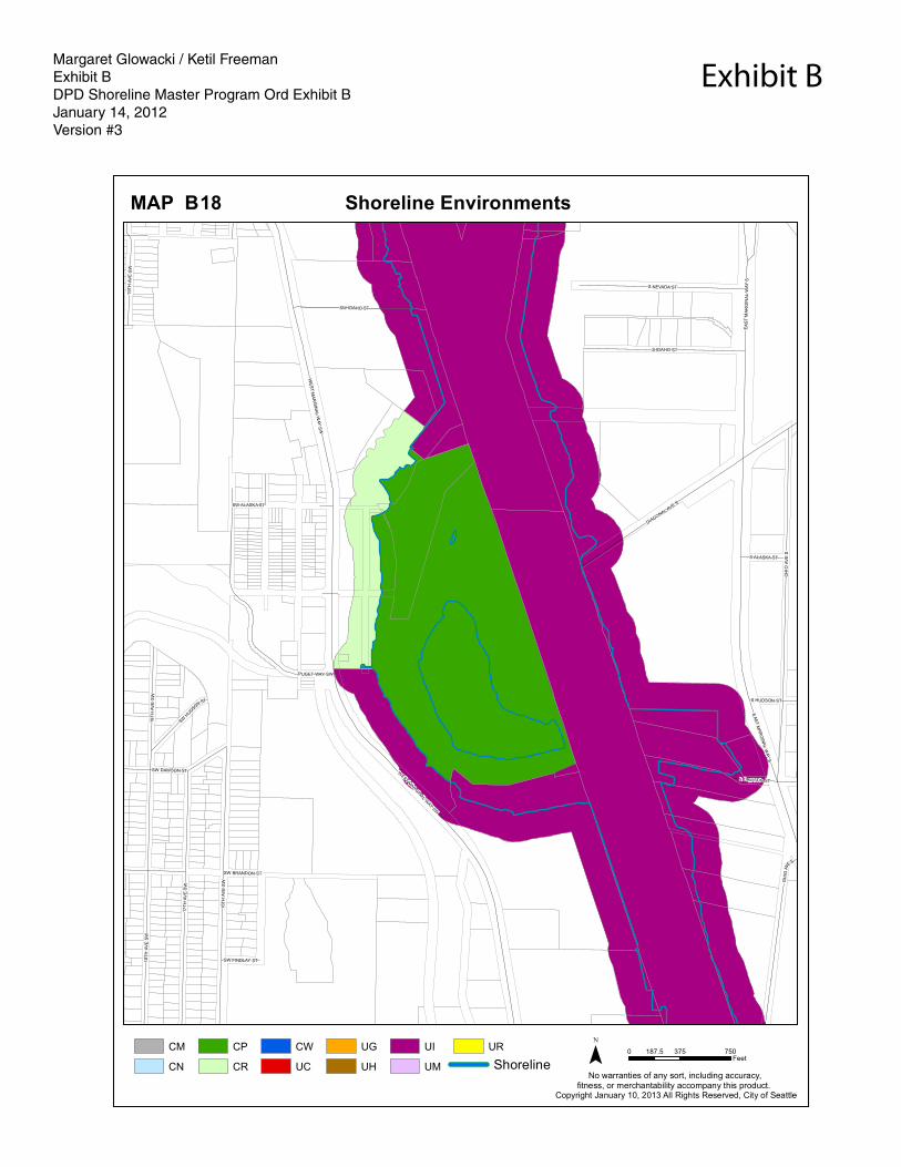
Exhibit B
FERRY AVE SW
SW HOLGATE ST
HARBORAVE
SW
SW MASSACHUSETTS ST
AR
CH
A VE
SW
ELM
PLS
W
SW HILL ST
SW WALKER ST
AR
CH
PL
SW
FAIR
MOUNT
AVE
SW
WAL
NUTAV
ESW
42N
DAV
ES
W
BELVIDERE
AVE
SW
VICTO
RIA
AVESW
41ST
AVE
SWW
ALN
UT
AVS
WA
CC
ES
SRD
PALM
AVE
SW
CALIFORN
IAW
AYSW
HARBORAVE
SW
No warranties of any sort, including accuracy, fitness, or merchantability accompany this product.
Copyright June 22, 2012 All Rights Reserved, City of Seattle
MAP B
0 220 440110Feet¯
Proposed Shoreline Environments17
URCM
CN
CP
CR
CW
UC
UG
UH
UI
UM
Change from CM to CR
Shoreline
Shoreline EnvironmentsMAP B17Offi cial Land Use Map Page 125 & 217
Change dry and submerged from Conservancy Management to Conservancy Recreation.
Margaret Glowacki / Ketil Freeman Exhibit BDPD Shoreline Master Program Ord Exhibit BJanuary 14, 2012Version #3
OH
I O AV
E S
S DAWSON ST
S IDAHO ST
SW IDAHO ST
DIAGONAL AVE S
1 8TH
A VE
SW
EA
ST
MA
RG
INA
L W
AY S
SW ALASKA ST
S HUDSON ST
PUGET WAY SW
SW DAWSON ST
EAS
T M
ARG
INA
L W
AY S
SW BRANDON ST
SW FINDLAY ST
S ALASKA ST
SW HUDSON ST
WE
ST
MA
RG
INA
L W
AY S
W
1 9TH
AVE
SW
16TH
AVE
SW
OH
IO AV
E S
WEST MARGINAL W
AY SW
1 7TH
A VE
SW
18TH
AVE
SW
S NEVADA ST
No warranties of any sort, including accuracy, fitness, or merchantability accompany this product.
Copyright January 10, 2013 All Rights Reserved, City of Seattle
MAP B
0 375 750187.5Feet¯
Shoreline Environments18
URCM
CN
CP
CR
CW
UC
UG
UH
UI
UM Shoreline
Margaret Glowacki / Ketil Freeman Exhibit BDPD Shoreline Master Program Ord Exhibit BJanuary 14, 2012Version #3
Margaret GlowackiDPD Shoreline Master Program ORD Exhibit BAugust 24, 2012Version #2
Maps of Shoreline Environments Exhibit B to the DPD Shoreline Master Program Ordinance2
Exhibit B
NW 13 1ST S T
NW NORCROSS WAY
NW 13 0TH ST
12T
HA
VEN
W
NW 13 2ND ST
9TH AVEN
W
NW 13 7TH ST
NW 12 5TH ST
1 2TH
AVE NW
ME
R
R IL L
LNN
W
3RD
AV
EN
W
CU
L PEPER
CT
NW
N 110TH S T
N 1 07 TH ST
12TH
AVE
NW
NW 1 06 TH ST
N 1 45 TH S TNW 1 45TH S T
3RD
PL
NW
NW 11 0TH ST
6T
HAV
EN
W
N W WOOD BI NE WAY
NW 11 5TH ST
3RD
AV
EN
W
NW CULB ERTSON DR
NW 121 ST ST
8TH
AV
EN
W
N W 13 7TH PL
NW 10 7TH ST
NW 116 TH ST
NW 1 43 RD S T
NW 14 0TH ST
ALPINE
WA
YN
W
NW 117TH S T
NW 120 TH ST
NW 1 32 ND S T
NW 12 7TH ST
NW 12 2ND ST
NW 1 30 TH ST
NW 12 7TH STNW 12 7TH ST
NW 12 5TH ST
NW 12 0TH ST
VALM
AYAVE NW
FR
AZ
IER
PL
NW
1ST
AVE
NW
H ILLTO
P
L NN W
NW 119TH S T
NW11 4TH
ST
8 TH
A
V ENW
NW 114T H P L
NW 11 8TH S T
5TH
AV
EN
W
NW 118 TH ST
N W 117TH S T
9T H AVE NW
N W CA RK EEK PAR K RD
NW BLA KELY CT
NW 1 20TH S T
NW 12 2ND ST
NW 1 26 TH S T
2N DAVE
NW
NW 116TH S T
BLA KELY PL NW1
3T H
AVE NW
NW 11 3TH PL
NW 1 44 TH ST
S H E RM
AN
RD
NW
NO
RT
HS
HIR
ER
D
NW
13TH
AV
EN
W
8TH
AV
EN
W
NW PUG ET DR
1ST
AV
EN
W
11T
HAV
EN
W
10TH
AV
EN
W
4TH
AV
EN
W
8T
HAV
EN
W
3RD
AV
EN
W
2 ND
AV
EN
W
7 TH
AV
EN
W
4TH
AV
EN
W
3RD
AV
EN
W
6TH
AV
EN
W
ELD
OR
AD
OL
NN
W
2ND
AV
EN
W2
ND
AV
EN
W
4TH
AV
EN
W
2 ND
AV
EN
W
1S
TA
VE
NW
3R
DA
VE
NW
NW 1 36 TH ST
2N
DA
VE
NW
NW 13 5TH PL
3RD
AV
EN
W
4TH
AV
EN
W
6TH
AV
EN
W
7TH
AV
EN
W
9TH
AV
EN
W
8TH
AV
EN
W
10TH
AV
EN
W
9TH
AV
EN
W
4T
HAV
EN
W
15T
HA
VE
NW
14TH
AV
EN
W
NW 112 TH ST
BO U N DARY LN NW
O LYM P IC DR NW
11TH
AV
EN
W
N W SCEN IC DR
11
THAVE
NW
NORTHWOOD RD N W
SH ER WO OD RD NW
NW 116 TH ST
NW N ORTH WOO D R D
N W CHERRY LOOP
NWE LFORD DR
No warranties of any sort, including accuracy, fitness, or merchantability accompany this product.
Copyright June 22, 2012 All Rights Reserved, City of Seattle
MAP B
0 720 1,440360Feet¯
Proposed Shoreline Environments1
URCM
CN
CP
CR
CW
UC
UG
UH
UI
UM
Change from CN to CP
Shoreline
Shoreline EnvironmentsMAP B1Offi cial Land Use Map Pages 1 & 10
Change submerged lands from Conservancy Navigation to Conservancy Preservation.