SEATTLE COMMUNITY DESIGN MMUN PROCESS FINAL … · August 2011 to July 2012: ... Seattle Community...
10
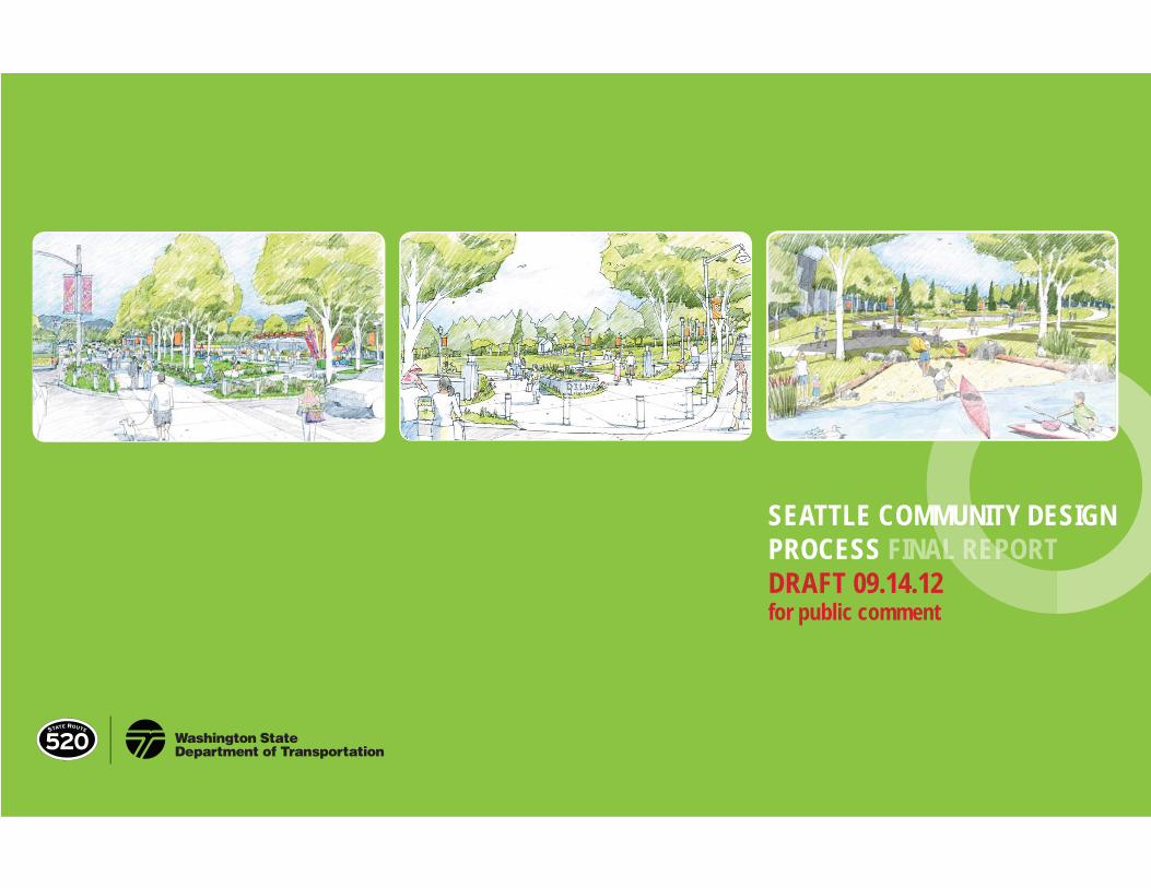
DRAFT ONLY for public comment SEATTLE COMMUNITY DESIGN PROCESS FINAL REPORT DRAFT 09.14.12 for public comment MMUN AL REPO
Transcript of SEATTLE COMMUNITY DESIGN MMUN PROCESS FINAL … · August 2011 to July 2012: ... Seattle Community...
DRAFT ONLYfor public comment
SEATTLE COMMUNITY DESIGN PROCESS FINAL REPORT DRAFT 09.14.12 for public comment
MMUN AL REPO

xxx • 3DRAFT ONLY
for public comment
01 EXECUTIVE SUMMARY
“Transportation planners must make decisions
that will support individuals and communities
in making healthy choices. A well designed
transportation project can go much beyond
its primary purpose of moving motor vehicles
by positively infl uencing the futures of
communities and the health of their residents.”
SR 520 Health Impact Assessment,
Seattle & King County Public Health, 2008
Executive Summary • 3
-
ƔƔƔƔƔƔƔƔƔ
EXECUTIVE SUMMARY
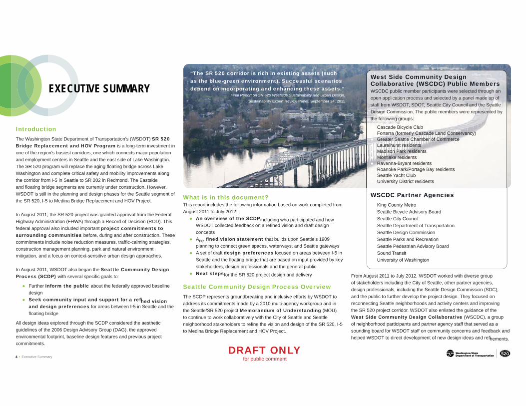
Introduction The Washington State Department of Transportation’s (WSDOT) SR 520 Bridge Replacement and HOV Program is a long-term investment in one of the region’s busiest corridors, one which connects major population and employment centers in Seattle and the east side of Lake Washington. The SR 520 program will replace the aging floating bridge across Lake Washington and complete critical safety and mobility improvements along the corridor from I-5 in Seattle to SR 202 in Redmond. The Eastside and floating bridge segments are currently under construction. However, WSDOT is still in the planning and design phases for the Seattle segment of the SR 520, I-5 to Medina Bridge Replacement and HOV Project.
In August 2011, the SR 520 project was granted approval from the Federal Highway Administration (FHWA) through a Record of Decision (ROD). This federal approval also included important project commitments to surrounding communities before, during and after construction. These commitments include noise reduction measures, traffi c-calming strategies, construction management planning, park and natural environment mitigation, and a focus on context-sensitive urban design approaches.
In August 2011, WSDOT also began the Seattle Community Design Process (SCDP) with several specific goals to:
Ɣ Further inform the public about the federally approved baseline design
Ɣ Seek community input and support for a refined vision and design preferences for areas between I-5 in Seattle and the fl oating bridge
All design ideas explored through the SCDP considered the aesthetic guidelines of the 2006 Design Advisory Group (DAG), the approved environmental footprint, baseline design features and previous project commitments.
4 • Executive Summary
“The SR 520 corridor is rich in existing assets (such as the blue-green environment). Successful scenarios depend on incorporating and enhancing these assets.”
Final Report on SR 520 Westside Sustainability and Urban Design, Sustainability Expert Review Panel, September 24, 2011
West Side Community Design Collaborative (WSCDC) Public Members WSCDC public member participants were selected through an open application process and selected by a panel made up of staff from WSDOT, SDOT, Seattle City Council and the Seattle Design Commission. The public members were represented by the following groups:
Cascade Bicycle ClubƔ Forterra (formerly Cascade Land Conservancy)Ɣ Greater Seattle Chamber of CommerceƔ Laurelhurst residentsƔ Madison Park residentsƔ Montlake residentsƔ Ravenna-Bryant residentsƔ Roanoke Park/Portage Bay residentsƔ Seattle Yacht Club Ɣ University District residentsƔ
WSCDC Partner Agencies King County Metro Seattle Bicycle Advisory Board Seattle City Council Seattle Department of Transportation Seattle Design Commission Seattle Parks and Recreation Seattle Pedestrian Advisory Board Sound Transit University of Washington
What is in this document? This report includes the following information based on work completed from August 2011 to July 2012: Ɣ An overview of the SCDP including who participated and how
WSDOT collected feedback on a refined vision and draft design concepts
Ɣ A re fi ned vision statement that builds upon Seattle’s 1909 planning to connect green spaces, waterways, and Seattle gateways
Ɣ A set of draft design preferences focused on areas between I-5 in Seattle and the floating bridge that are based on input provided by key stakeholders, design professionals and the general public
Ɣ Next steps for the SR 520 project design and delivery
Seattle Community Design Process Overview The SCDP represents groundbreaking and inclusive efforts by WSDOT to address its commitments made by a 2010 multi-agency workgroup and in the Seattle/SR 520 project Memorandum of Understanding (MOU) to continue to work collaboratively with the City of Seattle and Seattle neighborhood stakeholders to refine the vision and design of the SR 520, I-5 to Medina Bridge Replacement and HOV Project.
DRAFT ONLY for public comment
From August 2011 to July 2012, WSDOT worked with diverse group of stakeholders including the City of Seattle, other partner agencies, design professionals, including the Seattle Design Commission (SDC), and the public to further develop the project design. They focused on reconnecting Seattle neighborhoods and activity centers and improving the SR 520 project corridor. WSDOT also enlisted the guidance of the West Side Community Design Collaborative (WSCDC), a group of neighborhood participants and partner agency staff that served as a sounding board for WSDOT staff on community concerns and feedback and helped WSDOT to direct development of new design ideas and refinements.

= potential gatewayN N
University District
Montlake Area
Roanoke Area
Downtown Seattle
Lake Washington
Washington Park
Arboretum
520
I-5
University District
Montlake Area
Roanoke Area
Lake Washington
Washington Park
Arboretum
Downtown Seattle
Nature meets City
OVERALL VISION The SR 520 project corridor will be the premier gateway to the City of Seattle by reconnecting to the early Seattle
vision of “Nature meets City”
A conceptual-level diagram of Seattle’s 100-year vision as articulated in 1909 Seattle Parks A conceptual-level diagram of how SR 520 could build upon the 1909 vision to connect and Boulevards Plan Seattle’s green spaces, waterways and gateways A refi ned vision: Nature meets City
The new SR 520 project corridor is a critical regional highway facility that will support many modes of travel. WSDOT has the opportunity to build a more vibrant transportation facility through Seattle that could:
Ɣ Build upon Seattle’s vision set forth 100 years ago to become a
Washington Park Arboretum
Montlake
Blvd E
EIn
rlake
n Bl
vd
te
What we have achieved: Public awareness and community input Ɣ
Support of project elements Ɣ
AƔ refined vision and a set of design preferences based on the work completed to date
WSDOT will continue to engage with key stakeholders to affirm that the design preferences should be integrated into the I-5 to Medina project design.
premier city by creating infrastructure that embraces our unique natural setting and promotes a vibrant urban environment
Ɣ Yield affordable solutions and sustainability practices that support regional and local connectivity as well as ecology with a special focus on shoreline habitat and the use of low-carbon materials
Ɣ Provide a memorable experience for all users, including motorists, pedestrians, bicyclists, transit users, recreationists and residents of adjacent neighborhoods
A full version of this document Seattle Community Design Process Report
is available here: A conceptual-level diagram of the potential natural (east-west) and urban (north-south) axes that define the Seattle corridor http://www.wsdot.wa.gov/Projects/SR520Bridge/I5ToMedina/scdp.htm#reports
DRAFT ONLY Executive Summary • 5for public comment
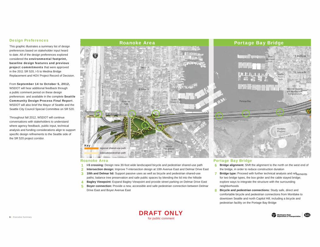
Design Preferences This graphic illustrates a summary list of design preferences based on stakeholder input heard to date. All of the design preferences explored considered the environmental footprint, baseline design features and previous project commitments that were approved in the 2011 SR 520, I-5 to Medina Bridge Replacement and HOV Project Record of Decision.
From September 14 to October 5, 2012, WSDOT will hear additional feedback through a public comment period on these design preferences and available in the complete Seattle Community Design Process Final Report. WSDOT will also brief the Mayor of Seattle and the Seattle City Council Special Committee on SR 520.
Throughout fall 2012, WSDOT will continue conversations with stakeholders to understand where agency feedback, public input, technical analysis and funding considerations align to support specific design refinements to the Seattle side of the SR 520 project corridor.
1
3
2
5
4 6 8
Roanoke Area Portage Bay Bridge
7
regional shared-use path
sidewalk/pedestrian path
Key
Roanoke Area Portage Bay Bridge 1 I-5 crossing: Design new 30-foot wide landscaped bicycle and pedestrian shared-use path 6 Bridge alignment: Shift the alignment to the north on the west end of 2 Intersection design: Improve T-intersection design at 10th Avenue East and Delmar Drive East the bridge, in order to reduce construction duration 3 10th and Delmar lid: Support passive uses as well as bicycle and pedestrian shared-use 7 Bridge type: Proceed with further technical analysis and refinements
paths; balance tree preservation and safe public spaces by blending the lid into the hillside for two bridge types, the box girder and the cable stayed bridge; 4 Bagley Viewpoint: Expand Bagley Viewpoint and provide street parking on Delmar Drive East explore ways to integrate the structure with the surrounding 5 Boyer connection: Provide a new, accessible and safe pedestrian connection between Delmar neighborhoods
Drive East and Boyer Avenue East 8 Bicycle and pedestrian connections: Study safe, direct and comfortable bicycle and pedestrian connections from Montlake to downtown Seattle and north Capitol Hill, including a bicycle and pedestrian facility on the Portage Bay Bridge
DRAFT ONLY 6 • Executive Summary for public comment

Washington Park Arboretum
9
12
10 13
11
15
14
16
Montlake Area West Approach Bridge
Montlake Option B Lowered transit/HOV ramps
Montlake Option A High transit/HOV ramps
Montlake
BlvdE
Montlake Area 9 Montlake Boulevard East: Continue to work with the City of Seattle and King
County Metro to improve safety, wayfinding, visual character and experience for cyclists and pedestrians
10 Canal Reserve: Lower the westbound off-ramps under 24th Avenue East and shift the regional shared-use path onto the Montlake lid to preserve trees and open space between the neighborhood and the westbound off-ramps
11 West Montlake lid: Develop a mobility hub that includes transit, bicycle and pedestrian facilities, safe connections to and from lid, and space for active uses
12 East Lake Washington Boulevard: Design the roadway to buffer neighbors from traffic, improve visual character and integrate with Washington Park Arboretum by increasing the planted buffer between the roadway and homes on the south side
13 24th Avenue East: Provide bicycle and pedestrian access only to East Montlake Park from 24th Avenue East
14 Stormwater facility: Integrate a constructed wetland facility into the existing East Montlake Park and shoreline area
15 East Montlake lid: Explore options to lower the transit/HOV ramps (see option B) and continue to work with the Seattle Design Commission (SDC), Seattle Department of Transportation (SDOT), Seattle Parks and Recreation, and Seattle Planning and Development to study options and refinements that best fit the project vision: to enhance connectivity for pedestrians, bicyclists and transit users; provide green space in an urban environment; and relate to the Arboretum
DRAFT ONLY for public comment
West Approach Bridge 16 Bridge design: Work toward a simple and clean
structural design; include belvedere viewing areas for the regional shared-use path on the north side of the bridge
Executive Summary • 7
December 2012
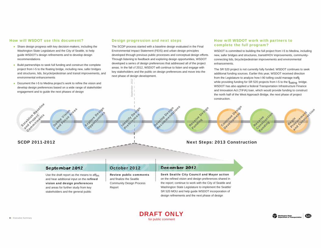
How will WSDOT use this document? Ɣ Share design progress with key decision-makers, including the
Washington State Legislature and the City of Seattle, to help guide WSDOT’s design refinements and to develop design recommendations
Ɣ Build partnerships to seek full funding and construct the complete project from I-5 to the floating bridge, including new, safer bridges and structures, lids, bicycle/pedestrian and transit improvements, and
Design progression and next steps The SCDP process started with a baseline design evaluated in the Final Environmental Impact Statement (FEIS) and urban design principles developed through previous public processes and conceptual design efforts. Through listening to feedback and exploring design opportunities, WSDOT developed a series of design preferences that addressed all of the projectes areas. In the fall of 2012, WSDOT will continue to listen and engage with key stakeholders and the public on design preferences and move into thea
o
How will WSDOT work with partners to complete the full program? WSDOT is committed to building the full project from I-5 to Medina, including new, safer bridges and structures, transit/HOV improvements, community-connecting lids, bicycle/pedestrian improvements and environmental enhancements.
The SR 520 project is not currently fully funded. WSDOT continues to seek additional funding sources. Earlier this year, WSDOT received direction
environmental enhancements
Document the I-5 to Medina project’s work to refine the vision andƔ
develop design preferences based on a wide range of stakeholder engagement and to guide the next phases of design
from the Legislature to analyze how I-90 tolling could manage traffic while providing funding for SR 520 projects from I-5 to the floating bridge. WSDOT has also applied a federal Transportation Infrastructure Finance and Innovation Act (TIFIA) loan, which would provide funding to construct the north half of the West Approach Bridge, the next phase of project construction.
next phase of design development.s
2012September 2012 Use the draft report as the means to affirm and hear additional input on the refi ned
October 2012 Review public comments and finalize the Seattle
Seek Seattle City Council and Mayor action on the refined vision and design preferences shared in
2012Seeptember 2012 2012DDecembber 20112 S k S ttl Cit CS
Contin
ue D
esig
n
Devel
opm
ent
Recei
ve
Const
ruct
ion
Fund
ing Beg
in
Procu
rem
ent
and
Const
ruct
ion
Next Steps: 2013 ConstructionSCDP 2011-2012
Iden
tify D
esig
n
Prefe
renc
es
Sep
tem
ber
2012
Rec
eive
Des
ign
Fund
ing
Explo
re D
esig
n
Oppor
tuni
ties
Devel
op D
esig
n
Recom
men
datio
ns
Defi ne
Vision
and
Focu
s Are
as
Estab
lish
Basel
ine
and
Proje
ct
Comm
itmen
ts
vision and design preferences Community Design Process the report; continue to work with the City of Seattle and and areas for further study from key Report Washington State Legislature to implement the Seattle/ stakeholders and the general public SR 520 MOU and help guide WSDOT incorporation of
design refinements and the next phase of design
DRAFT ONLY 8 • Executive Summary for public comment

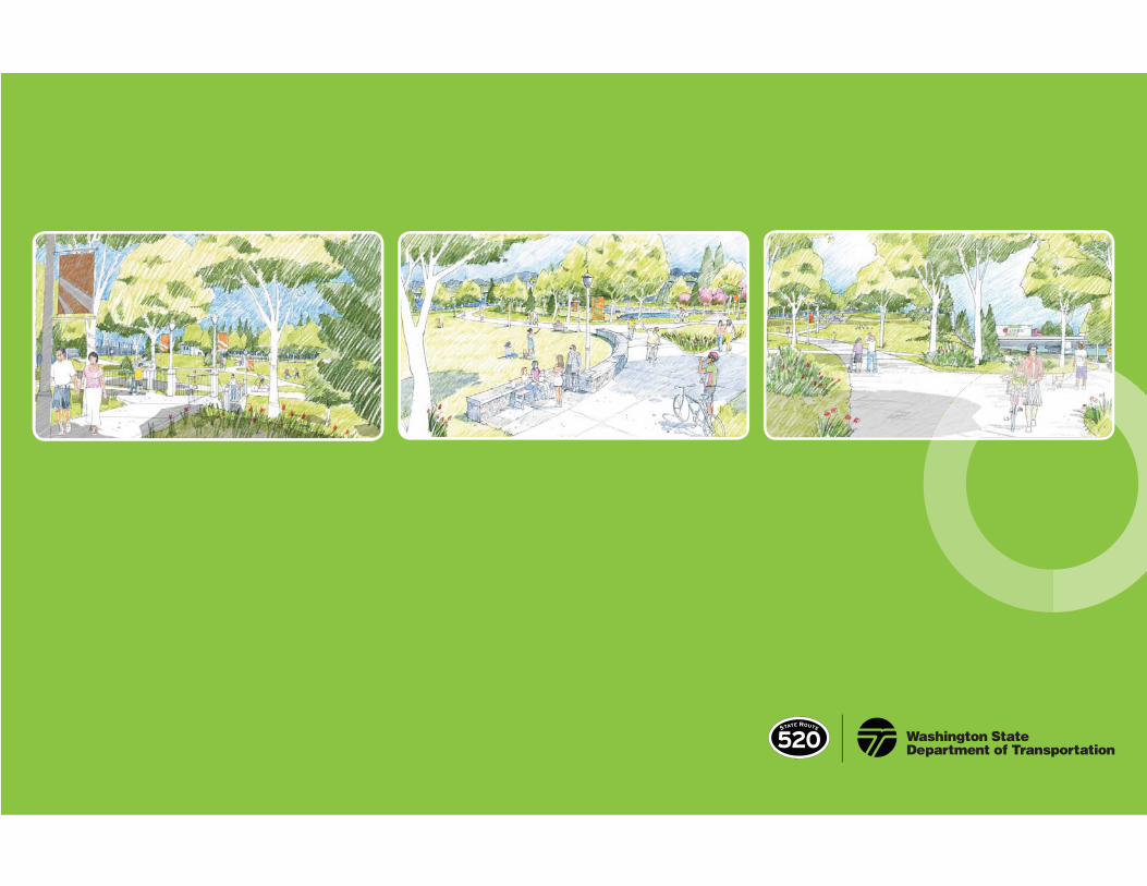
Conceptual Rendering The western portion of the Montlake lid over SR 520 will serve as a mobility hub including transit stops and could
have spaces for public markets or other active uses (view looking north from East Lake Washington Boulevard)
DRAFT ONLY Executive Summary • 9for public comment