Season's Greetings - Lincoln Highway Association
21
VOL. 14 NO. 1 WINTER JANUARY, 2013 Season's Greetings Have a Merry Christmas and a Happy New Year Caltrans, Library and History Center Lower French Camp Turnpike entering French Camp from north. Beattie Store and Service Station on far side of intersection with Ash Street (West Side Road). 1925 EDITOR Gary Kinst PUBLISHED QUARTERLY ON THE FIRST OF JANUARY, APRIL, JULY, OCTOBER THE TRAVELER LINCOLN HIGHWAY ASSOCIATION - CALIFORNIA CHAPTER www.lincolnhwy.org/ca/traveler
Transcript of Season's Greetings - Lincoln Highway Association
VOL. 14 NO. 1 WINTER JANUARY, 2013
Season's Greetings Have a Merry Christmas and a Happy New Year
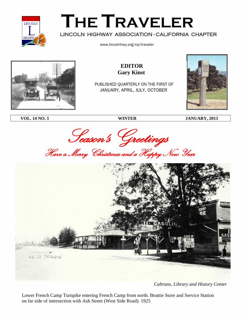
Caltrans, Library and History Center
Lower French Camp Turnpike entering French Camp from north. Beattie Store and Service Station
on far side of intersection with Ash Street (West Side Road). 1925
EDITOR
Gary Kinst
PUBLISHED QUARTERLY ON THE FIRST OF
JANUARY, APRIL, JULY, OCTOBER
THE TRAVELER LINCOLN HIGHWAY ASSOCIATION - CALIFORNIA CHAPTER
www.lincolnhwy.org/ca/traveler
Cover
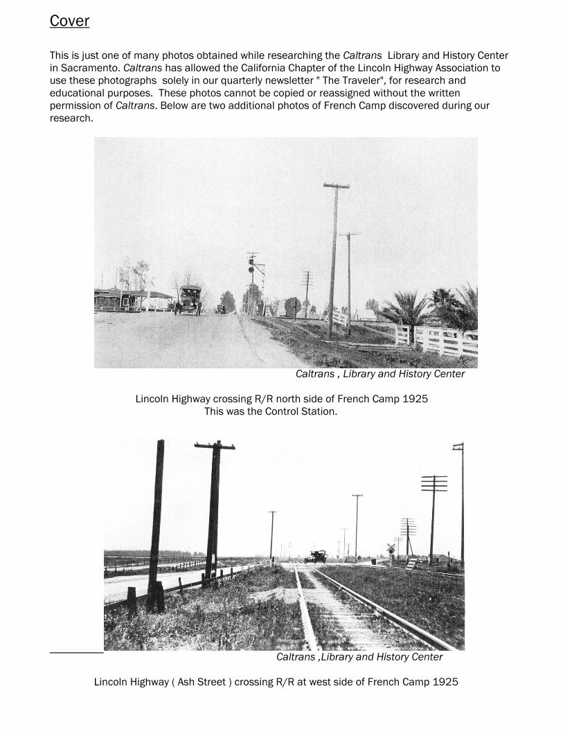
This is just one of many photos obtained while researching the Caltrans Library and History Center
in Sacramento. Caltrans has allowed the California Chapter of the Lincoln Highway Association to
use these photographs solely in our quarterly newsletter " The Traveler", for research and
educational purposes. These photos cannot be copied or reassigned without the written
permission of Caltrans. Below are two additional photos of French Camp discovered during our
research.
Caltrans , Library and History Center
Lincoln Highway crossing R/R north side of French Camp 1925
This was the Control Station.
Caltrans ,Library and History Center
Lincoln Highway ( Ash Street ) crossing R/R at west side of French Camp 1925
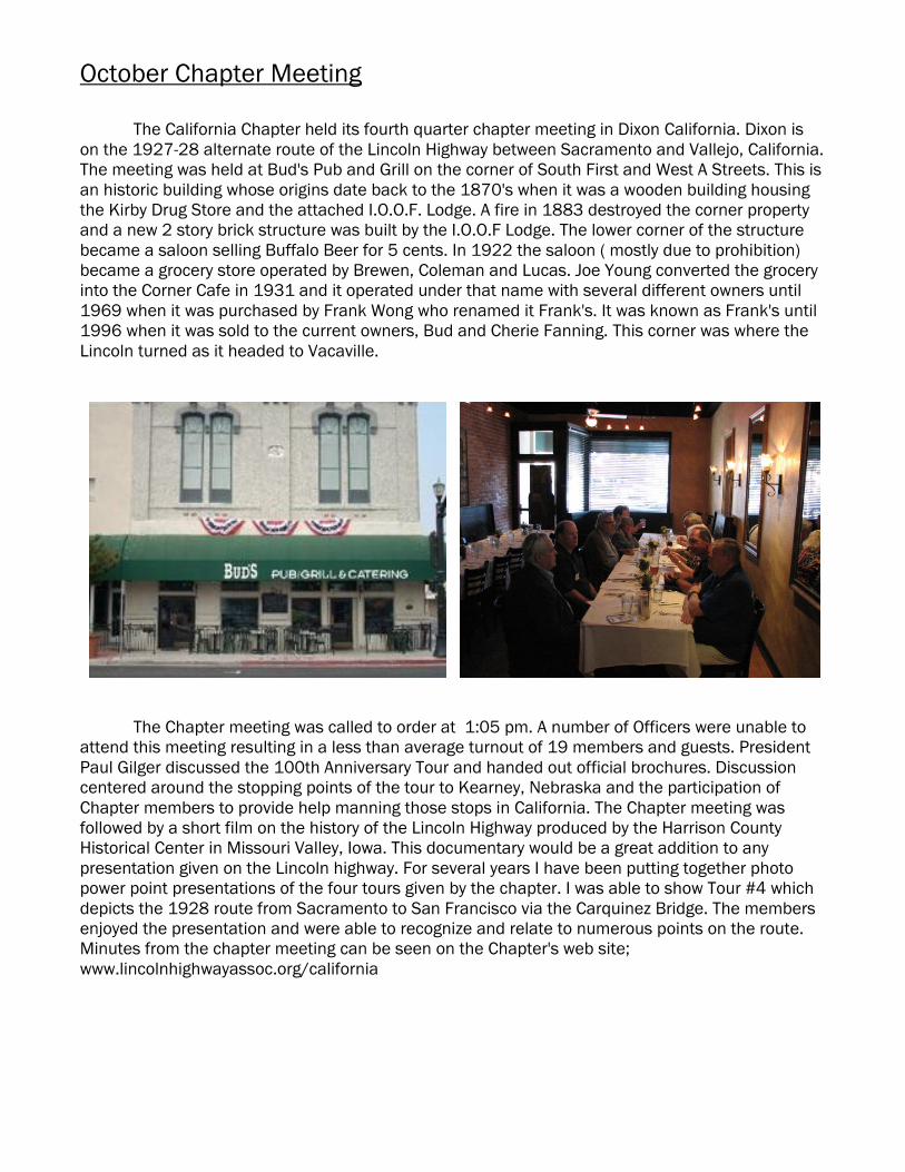
October Chapter Meeting
The California Chapter held its fourth quarter chapter meeting in Dixon California. Dixon is
on the 1927-28 alternate route of the Lincoln Highway between Sacramento and Vallejo, California.
The meeting was held at Bud's Pub and Grill on the corner of South First and West A Streets. This is
an historic building whose origins date back to the 1870's when it was a wooden building housing
the Kirby Drug Store and the attached I.O.O.F. Lodge. A fire in 1883 destroyed the corner property
and a new 2 story brick structure was built by the I.O.O.F Lodge. The lower corner of the structure
became a saloon selling Buffalo Beer for 5 cents. In 1922 the saloon ( mostly due to prohibition)
became a grocery store operated by Brewen, Coleman and Lucas. Joe Young converted the grocery
into the Corner Cafe in 1931 and it operated under that name with several different owners until
1969 when it was purchased by Frank Wong who renamed it Frank's. It was known as Frank's until
1996 when it was sold to the current owners, Bud and Cherie Fanning. This corner was where the
Lincoln turned as it headed to Vacaville.
The Chapter meeting was called to order at 1:05 pm. A number of Officers were unable to
attend this meeting resulting in a less than average turnout of 19 members and guests. President
Paul Gilger discussed the 100th Anniversary Tour and handed out official brochures. Discussion
centered around the stopping points of the tour to Kearney, Nebraska and the participation of
Chapter members to provide help manning those stops in California. The Chapter meeting was
followed by a short film on the history of the Lincoln Highway produced by the Harrison County
Historical Center in Missouri Valley, Iowa. This documentary would be a great addition to any
presentation given on the Lincoln highway. For several years I have been putting together photo
power point presentations of the four tours given by the chapter. I was able to show Tour #4 which
depicts the 1928 route from Sacramento to San Francisco via the Carquinez Bridge. The members
enjoyed the presentation and were able to recognize and relate to numerous points on the route.
Minutes from the chapter meeting can be seen on the Chapter's web site;
www.lincolnhighwayassoc.org/california
IN SEARCH OF THE LINCOLN IN LIVERMORE
In the ongoing search for information and photographs of the Lincoln Highway in California,
Myself and other members of the California Chapter are continually uncovering or stumbling over
hidden treasure troves. We all realize that the Lincoln has been realigned numerous times in many
areas with the intent to make the highway easier and safer to travel. The first alignment in 1913 was
limited to existing paths, trails and preexisting county roads. These early right-of-ways were laid out
around existing land parcels and were restricted to following property lines. It wasn't until years later
that property owners granted encroachment upon their properties. Straight stretches of roadway and
sweeping curves were still in the future.
Our research is primarily focused on determining the original 1913-1915 alignment.
We strive to research the most factual and authentic materials available to us. These include
original state and county maps, Caltrans As-Built plans and maps published by the Automobile Club
of Southern California and California State Automobile Association. Maps from Oil companies and
mapping companies are also extremely helpful although some early publications such as the "Pacific
Road Guide to Northern California 1914-15" over simplifies the path of the road and doesn't provide
much detail. Google Earth and other topographical mapping companies provide photos that allow us
to find hidden alignments that can't always be seen at ground level. And last but -not -least is good
old foot work. Trekking over hill and dale can be rewarding and disappointing at the same time.
This brings us to Livermore. Member Michael Kaelin is working hard to obtain permission and
backing to install Historic Lincoln Highway signs along the 1913 route in San Joaquin and Alameda
Counties prior to the 2013 Centennial Tour. As stated in previous Travelers, Mike has been
successful in erecting signs between Lathrop and San Leandro but several key locations still remain
un-marked.
A question has arisen in Livermore regarding the actual alignment that the Lincoln followed.
Before signs can be installed, the original routing must be confirmed. We don't wish to error and
install signage on a street or road that wasn't part of the Lincoln in 1913-1915 or in a worse case,
on a road that was never an alignment of the Lincoln.
We have always known that the Lincoln entered Livermore, after exiting the Altamont Pass
and heading straight west, on First Street. What has been questioned lately, is what route did it
follow once reaching the outskirts of Livermore proper ? Did it continue on First and then turn right
on Junction heading N/W to meet the Dublin Road ? Or, did it turn right on Portola Avenue by-
passing central Livermore and avoiding crossing the railroad twice ? The theory has been presented
that the Lincoln did indeed turn on Portola sometime after 1915. This theory is what we intend to
prove or disprove.
Maps as early as 1878 show the Stockton Road entering Livermore from the East and
turning onto the Dublin-Laddsville Rd. which would later become Junction Avenue [figure 1]. The
USGS map from 1906 [figure 2] shows the highway routing through Livermore to be the same as in
the 1878 map. There is still no road where the present day Portola Avenue exists. A June 30, 1914
Plan and Profile Proposal [figure 3 & 4] for a State Highway realignment between Greenville and
Livermore by the California Highway Commission shows the proposed route that would bypass
Junction Avenue on what was known as Highland Avenue. Research at the Caltrans library in
Sacramento uncovered no evidence that this proposal was ever completed.
Chapter V.P. Joel Windmiller along with Jason Bezis , Editor of the Livermore Heritage Guild
newsletter, uncovered a contract number dated 08/11/14 referencing this proposal. Contract
Number 90 was awarded to Parrott Bros. Co. of Salt Lake City, Utah for the construction of a 15' x 4"
concrete base extending 4.97 miles between Greenville and Livermore. Jason's research also
discovered that Highland Avenue came into existence when Livermore Heights was developed in
1888. Highland ran from First St. to Enos, which turned S/W terminating at Junction Ave. An article
in the June 19, 1915 Livermore Herald stated that the Parrott Bros. had finished the cement work
on the State Highway.
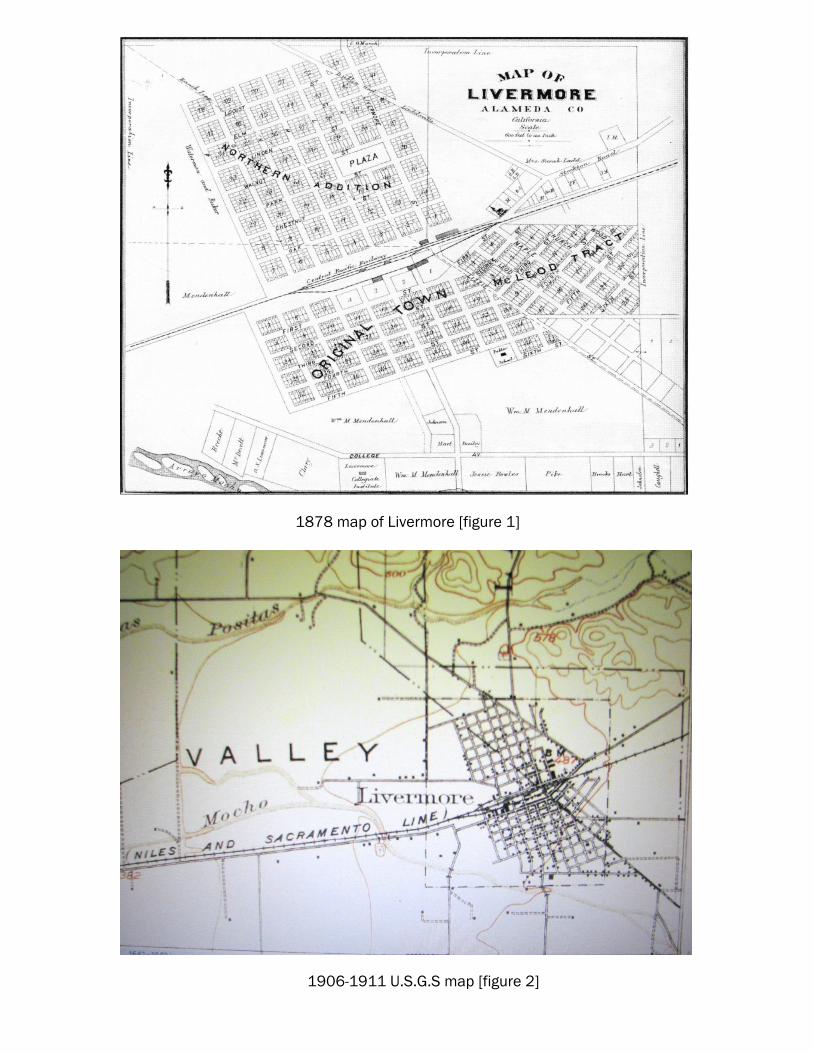
1878 map of Livermore [figure 1]
1906-1911 U.S.G.S map [figure 2]
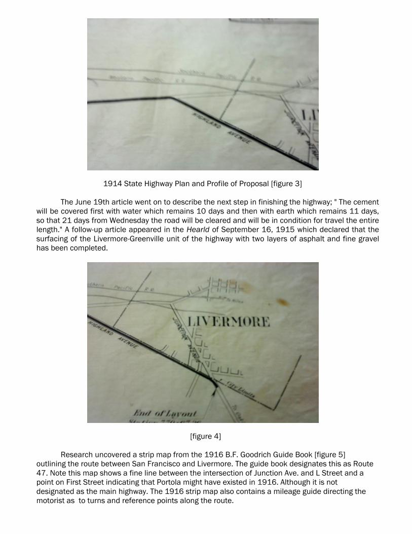
1914 State Highway Plan and Profile of Proposal [figure 3]
The June 19th article went on to describe the next step in finishing the highway; " The cement
will be covered first with water which remains 10 days and then with earth which remains 11 days,
so that 21 days from Wednesday the road will be cleared and will be in condition for travel the entire
length." A follow-up article appeared in the Hearld of September 16, 1915 which declared that the
surfacing of the Livermore-Greenville unit of the highway with two layers of asphalt and fine gravel
has been completed.
[figure 4]
Research uncovered a strip map from the 1916 B.F. Goodrich Guide Book [figure 5]
outlining the route between San Francisco and Livermore. The guide book designates this as Route
47. Note this map shows a fine line between the intersection of Junction Ave. and L Street and a
point on First Street indicating that Portola might have existed in 1916. Although it is not
designated as the main highway. The 1916 strip map also contains a mileage guide directing the
motorist as to turns and reference points along the route.
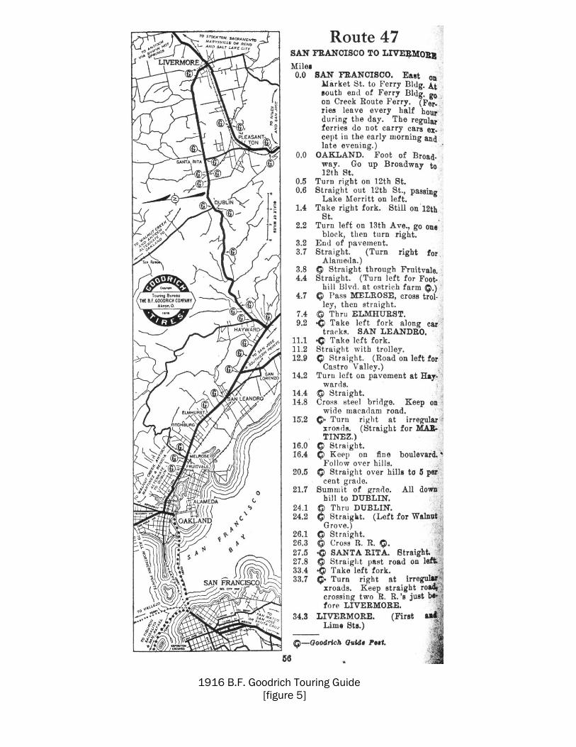
1916 B.F. Goodrich Touring Guide
[figure 5]
Using [figure 4] as a comparison, the B.F. Goodrich strip map [figure 5] confirms that the
State Highway (Lincoln Highway) followed Highland Avenue into Livermore from the south. Guide
Post on map at mileage mark 33.4 instructs the motorist to turn left at fork, which would be
Highland Avenue, then turn right at irregular x roads at 33.7. After turning right onto First the
motorist is instructed to continue straight before crossing the two railroads. This would have been
the intersection of First Street and Highland. Continuing straight the motorist is told to cross two R.
R.'s before entering Livermore at mileage mark 34.3. If the highway had followed the Junction
Avenue route to First Street the motorist would have turned right at mile mark 33.4 and would have
crossed the Western Pacific tracks before turning right onto First and then crossing the Southern
Pacific tracks.
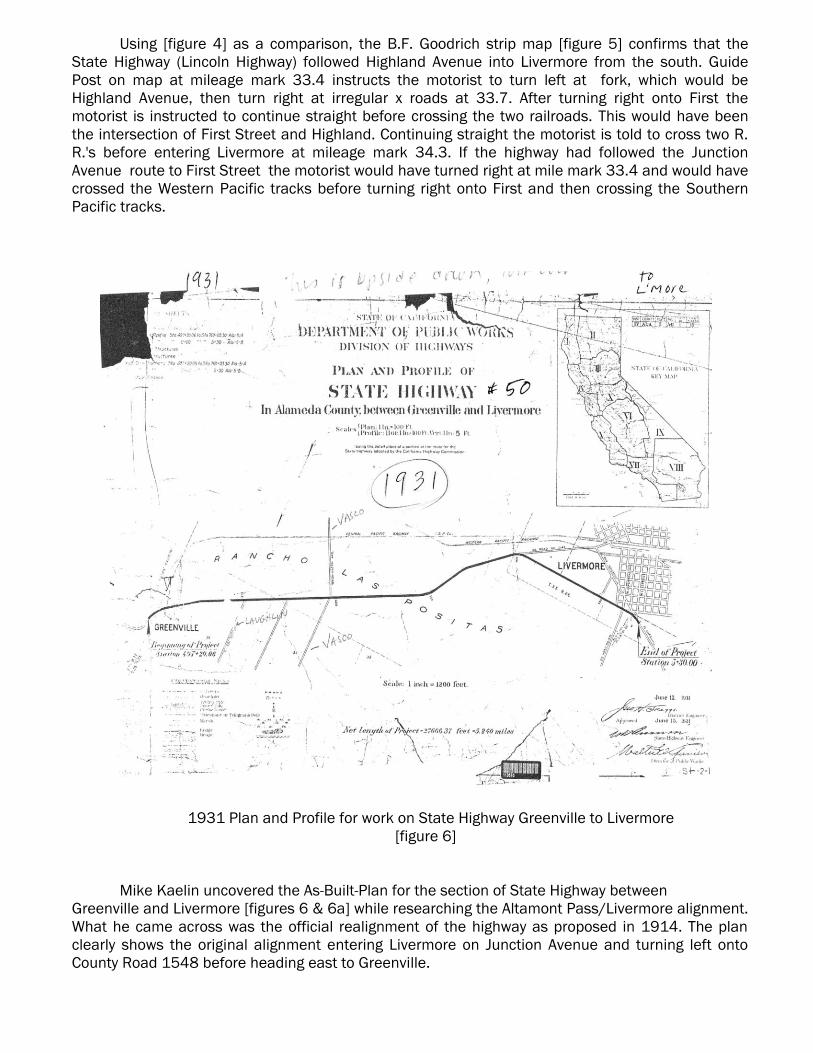
1931 Plan and Profile for work on State Highway Greenville to Livermore
[figure 6]
Mike Kaelin uncovered the As-Built-Plan for the section of State Highway between
Greenville and Livermore [figures 6 & 6a] while researching the Altamont Pass/Livermore alignment.
What he came across was the official realignment of the highway as proposed in 1914. The plan
clearly shows the original alignment entering Livermore on Junction Avenue and turning left onto
County Road 1548 before heading east to Greenville.
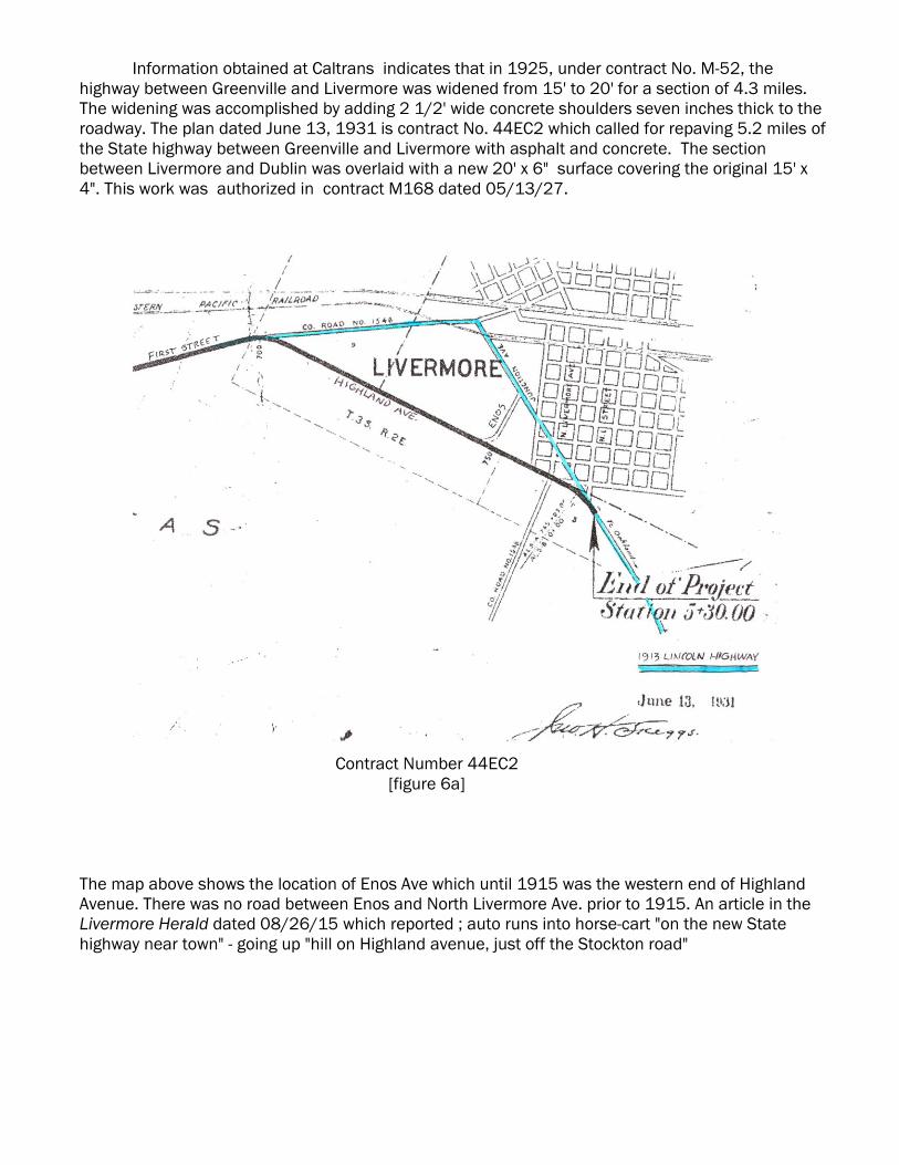
Information obtained at Caltrans indicates that in 1925, under contract No. M-52, the
highway between Greenville and Livermore was widened from 15' to 20' for a section of 4.3 miles.
The widening was accomplished by adding 2 1/2' wide concrete shoulders seven inches thick to the
roadway. The plan dated June 13, 1931 is contract No. 44EC2 which called for repaving 5.2 miles of
the State highway between Greenville and Livermore with asphalt and concrete. The section
between Livermore and Dublin was overlaid with a new 20' x 6" surface covering the original 15' x
4". This work was authorized in contract M168 dated 05/13/27.
Contract Number 44EC2
[figure 6a]
The map above shows the location of Enos Ave which until 1915 was the western end of Highland
Avenue. There was no road between Enos and North Livermore Ave. prior to 1915. An article in the
Livermore Herald dated 08/26/15 which reported ; auto runs into horse-cart "on the new State
highway near town" - going up "hill on Highland avenue, just off the Stockton road"
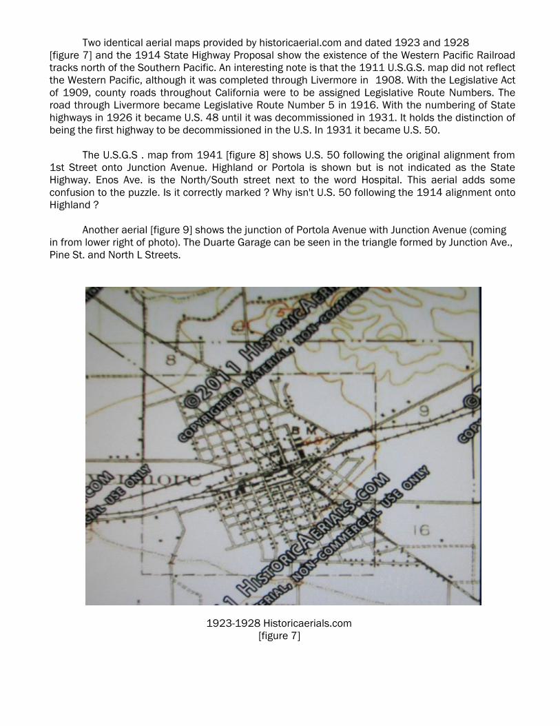
Two identical aerial maps provided by historicaerial.com and dated 1923 and 1928
[figure 7] and the 1914 State Highway Proposal show the existence of the Western Pacific Railroad
tracks north of the Southern Pacific. An interesting note is that the 1911 U.S.G.S. map did not reflect
the Western Pacific, although it was completed through Livermore in 1908. With the Legislative Act
of 1909, county roads throughout California were to be assigned Legislative Route Numbers. The
road through Livermore became Legislative Route Number 5 in 1916. With the numbering of State
highways in 1926 it became U.S. 48 until it was decommissioned in 1931. It holds the distinction of
being the first highway to be decommissioned in the U.S. In 1931 it became U.S. 50.
The U.S.G.S . map from 1941 [figure 8] shows U.S. 50 following the original alignment from
1st Street onto Junction Avenue. Highland or Portola is shown but is not indicated as the State
Highway. Enos Ave. is the North/South street next to the word Hospital. This aerial adds some
confusion to the puzzle. Is it correctly marked ? Why isn't U.S. 50 following the 1914 alignment onto
Highland ?
Another aerial [figure 9] shows the junction of Portola Avenue with Junction Avenue (coming
in from lower right of photo). The Duarte Garage can be seen in the triangle formed by Junction Ave.,
Pine St. and North L Streets.
1923-1928 Historicaerials.com
[figure 7]
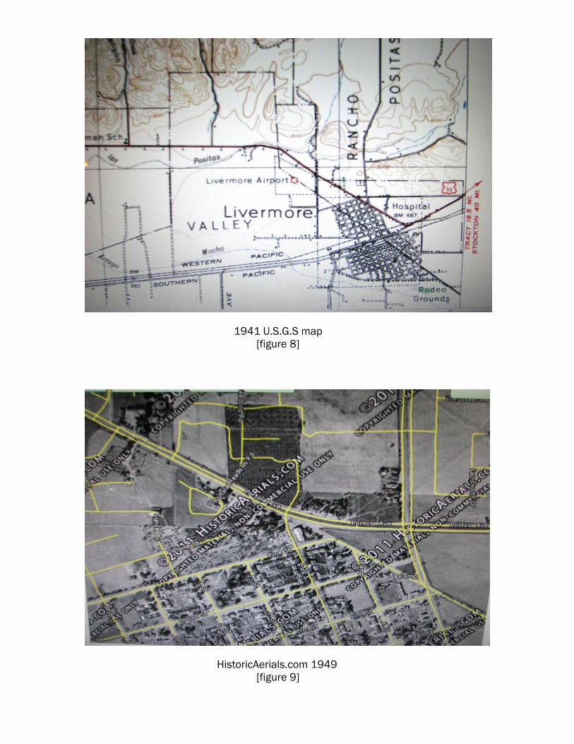
1941 U.S.G.S map
[figure 8]
HistoricAerials.com 1949
[figure 9]
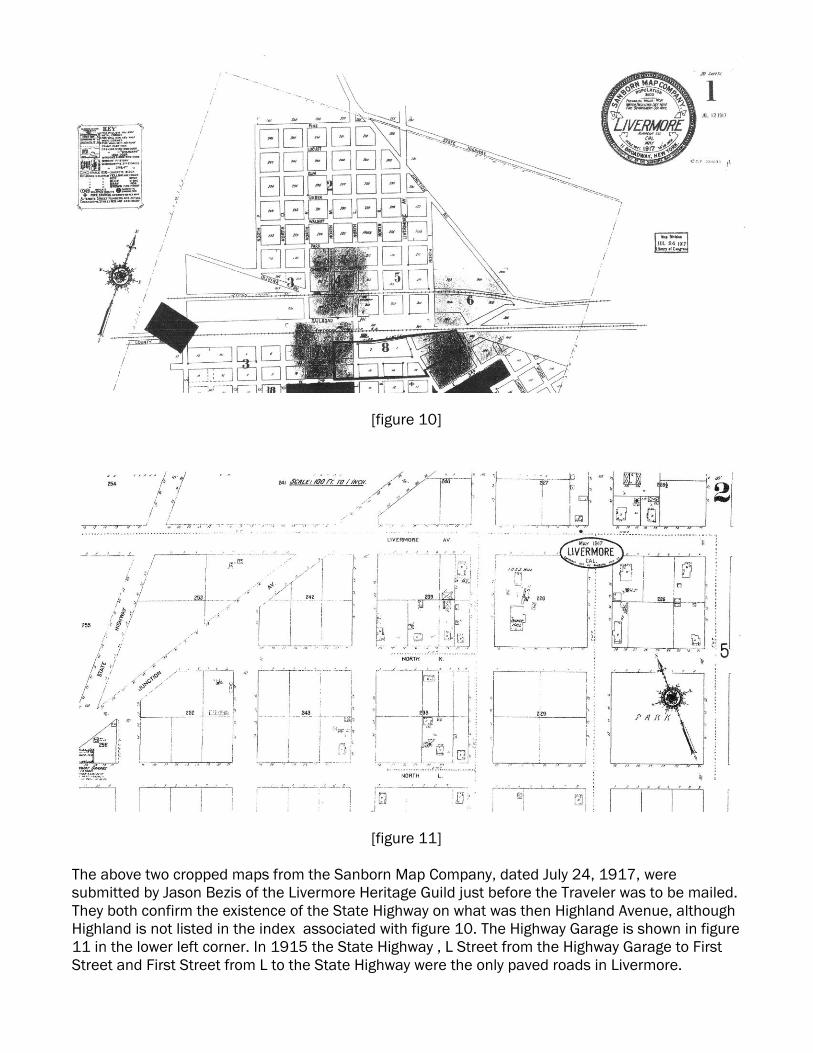
[figure 10]
[figure 11]
The above two cropped maps from the Sanborn Map Company, dated July 24, 1917, were
submitted by Jason Bezis of the Livermore Heritage Guild just before the Traveler was to be mailed.
They both confirm the existence of the State Highway on what was then Highland Avenue, although
Highland is not listed in the index associated with figure 10. The Highway Garage is shown in figure
11 in the lower left corner. In 1915 the State Highway , L Street from the Highway Garage to First
Street and First Street from L to the State Highway were the only paved roads in Livermore.
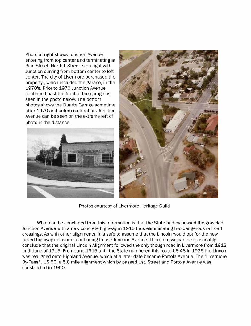
Photos courtesy of Livermore Heritage Guild
What can be concluded from this information is that the State had by passed the graveled
Junction Avenue with a new concrete highway in 1915 thus elimininating two dangerous railroad
crossings. As with other alignments, it is safe to assume that the Lincoln would opt for the new
paved highway in favor of continuing to use Junction Avenue. Therefore we can be reasonably
conclude that the original Lincoln Alignment followed the only though road in Livermore from 1913
until June of 1915. From June,1915 until the State numbered this route US 48 in 1926,the Lincoln
was realigned onto Highland Avenue, which at a later date became Portola Avenue. The "Livermore
By-Pass" , US 50, a 5.8 mile alignment which by passed 1st. Street and Portola Avenue was
constructed in 1950.
Photo at right shows Junction Avenue
entering from top center and terminating at
Pine Street. North L Street is on right with
Junction curving from bottom center to left
center. The city of Livermore purchased the
property , which included the garage, in the
1970's. Prior to 1970 Junction Avenue
continued past the front of the garage as
seen in the photo below. The bottom
photos shows the Duarte Garage sometime
after 1970 and before restoration. Junction
Avenue can be seen on the extreme left of
photo in the distance.
Special Note I have been informed that Kathy Franzwa, Editor of the Lincoln Highway Forum, is relocating
to Washington state. After the passing of her husband Greg, Kathy has been busy getting things in
order and has decided to close the Patrice Press, although the Forum will continue to be published.
She has been lucky enough to sell her home and move near her parents in Marysville, Washington.
I will have to research if any historic highways pass near Marysville. For those of you who would like
to submit something for the Forum, Kathy can be reached by e-mail at; [email protected]
or by snail-mail at; 8017 64th Dr. NE, Marysville, WA 98270. The California Chapter wishes Kathy
the best in her new adventure and we will certainly miss the Press.
Donner Summit Bridge Plaque Installation A date has yet to be set for the installation of a new commerative plaque at the site of the
original bronze plaque which had been vandalized. Leon Schegg is asking for volunteers to help in
placing this replica plaque. Hopefully by the time the next Traveler is published in April, a date will
have been selected. If you would like to be part of this project, please contact Leon at;
Signing the Lincoln Mike Kaelin has been busy with representatives in Alameda, Contra Costa Counties and
local cities to get signage posted along the Lincoln. An agreement has been reached in Livermore
to install 7-8 signs along First Street and Junction Avenue. The City of Livermore has requested
that the signs be coated with a "anti-graffiti" coating and placed 8 feet above street level to
prevent vandalism. The signs will be posted on existing traffic sign post to save permit and labor
costs. The City of El Cerrito has obtained approval to install 4 Historic Lincoln Highway signs on
San Pablo Avenue. Finalizing exact locations for each sign is the next step in the completion of
these projects. Mike is well on his way to having a well signed route for the 2013 Centennial Tour.
Eagle Scout Project The Chapter has been approached by Boy Scout Nathan Balaguy of Meadow Vista, Ca..
Nathan is planning an Eagle Scout project and would like to be part of organizing the installation of
a replica 1928 concrete marker to be placed at a location along the Lincoln Highway in Placer
County. The marker would be placed where an original marker once stood. This project is similar to
the one undertaken by Eagle Scout Will McKinney of Rescue, CA. and reported in the October,
2009 Traveler (Vol. 10 No. 4). Nathan has been sent a copy of Gael Hoag's marker placement
guide, which will help him choose a correct location. The Chapter is in possession of Norm Root's
mold for reproducing the markers. but will require help in finding someone with experience and
space to cast more markers. If your that person, please contact the California Chapter.
Missing Traveler Issue In our effort to post all issues of the Traveler on the web site, we have been searching high
and low for missing copies. Numerous issues were discovered in the Chapters historical files held
by Norm Root and those issues brought us up to date with the exception of one elusive issue edited
by James Lin after the passing of Wes Hammond. That is Traveler Vol. 5 No. 2 ,the Spring issue of
2004. If any members have saved their past issues and perchance have a copy of that issue, we
would be most grateful if you would allow us to scan and copy that issue so that we may complete
the collection.
Thank You; Gary Kinst
Vacaville Alignment
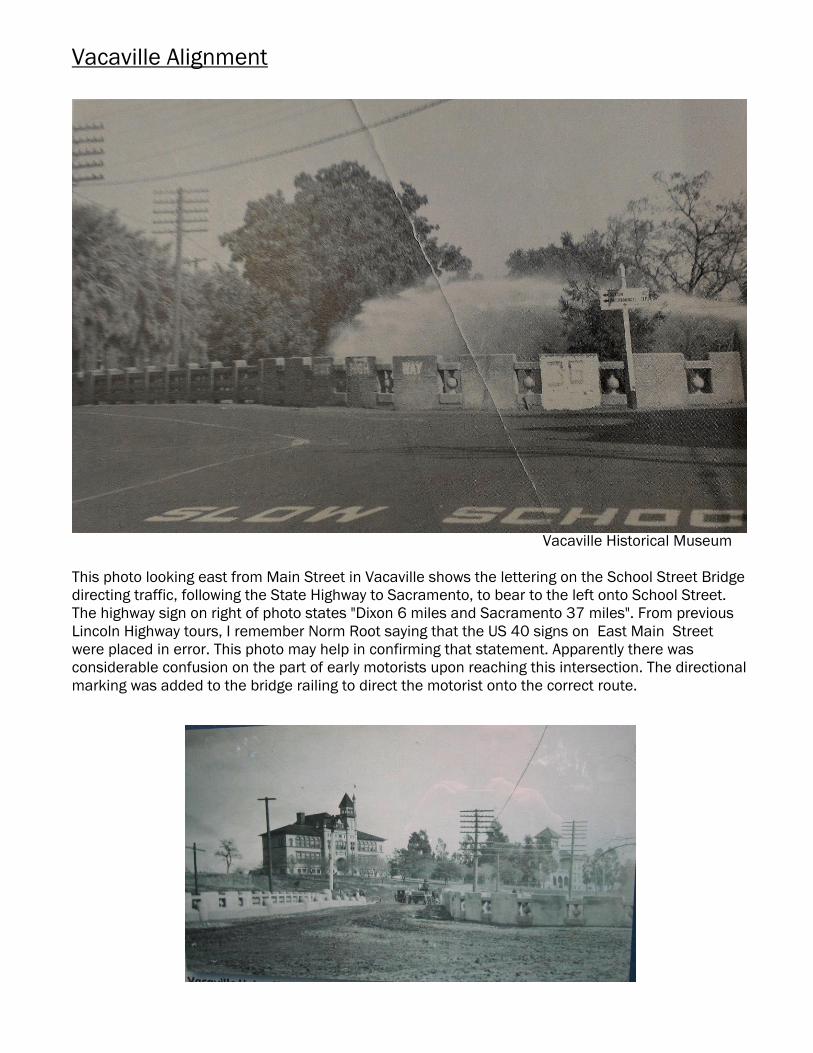
Vacaville Historical Museum
This photo looking east from Main Street in Vacaville shows the lettering on the School Street Bridge
directing traffic, following the State Highway to Sacramento, to bear to the left onto School Street.
The highway sign on right of photo states "Dixon 6 miles and Sacramento 37 miles". From previous
Lincoln Highway tours, I remember Norm Root saying that the US 40 signs on East Main Street
were placed in error. This photo may help in confirming that statement. Apparently there was
considerable confusion on the part of early motorists upon reaching this intersection. The directional
marking was added to the bridge railing to direct the motorist onto the correct route.
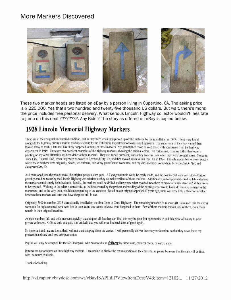
More Markers Discovered
These two marker heads are listed on eBay by a person living in Cupertino, CA. The asking price
is $ 225,000, Yes that's two hundred and twenty-five thousand US dollars. But wait, there's more;
the price includes free personal delivery. What serious Lincoln Highway collector wouldn't hesitate
to jump on this deal ????????. Any Bids ? The story as offered on eBay is copied below.
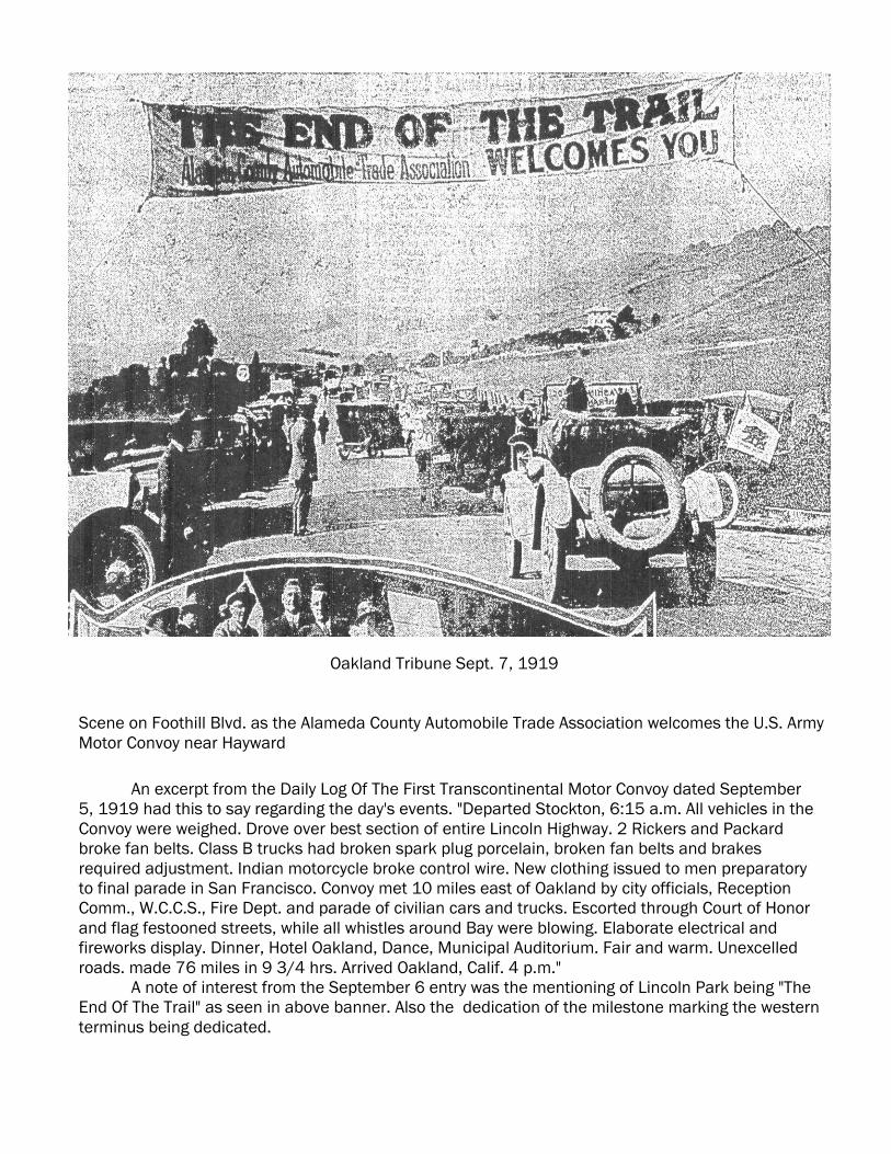
Oakland Tribune Sept. 7, 1919
Scene on Foothill Blvd. as the Alameda County Automobile Trade Association welcomes the U.S. Army
Motor Convoy near Hayward
An excerpt from the Daily Log Of The First Transcontinental Motor Convoy dated September
5, 1919 had this to say regarding the day's events. "Departed Stockton, 6:15 a.m. All vehicles in the
Convoy were weighed. Drove over best section of entire Lincoln Highway. 2 Rickers and Packard
broke fan belts. Class B trucks had broken spark plug porcelain, broken fan belts and brakes
required adjustment. Indian motorcycle broke control wire. New clothing issued to men preparatory
to final parade in San Francisco. Convoy met 10 miles east of Oakland by city officials, Reception
Comm., W.C.C.S., Fire Dept. and parade of civilian cars and trucks. Escorted through Court of Honor
and flag festooned streets, while all whistles around Bay were blowing. Elaborate electrical and
fireworks display. Dinner, Hotel Oakland, Dance, Municipal Auditorium. Fair and warm. Unexcelled
roads. made 76 miles in 9 3/4 hrs. Arrived Oakland, Calif. 4 p.m."
A note of interest from the September 6 entry was the mentioning of Lincoln Park being "The
End Of The Trail" as seen in above banner. Also the dedication of the milestone marking the western
terminus being dedicated.
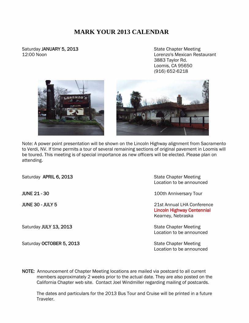
MARK YOUR 2013 CALENDAR
Saturday JANUARY 5, 2013 State Chapter Meeting
12:00 Noon Lorenzo's Mexican Restaurant
3883 Taylor Rd.
Loomis, CA 95650
(916) 652-6218
Note: A power point presentation will be shown on the Lincoln Highway alignment from Sacramento
to Verdi, NV. If time permits a tour of several remaining sections of original pavement in Loomis will
be toured. This meeting is of special importance as new officers will be elected. Please plan on
attending.
Saturday APRIL 6, 2013 State Chapter Meeting
Location to be announced
JUNE 21 - 30 100th Anniversary Tour
JUNE 30 - JULY 5 21st Annual LHA Conference
Lincoln Highway Centennial
Kearney, Nebraska
Saturday JULY 13, 2013 State Chapter Meeting
Location to be announced
Saturday OCTOBER 5, 2013 State Chapter Meeting
Location to be announced
NOTE: Announcement of Chapter Meeting locations are mailed via postcard to all current
members approximately 2 weeks prior to the actual date. They are also posted on the
California Chapter web site. Contact Joel Windmiller regarding mailing of postcards.
The dates and particulars for the 2013 Bus Tour and Cruise will be printed in a future
Traveler.
P.O. Box 2554
Fair Oaks, CA 95626
Paul Gilger Bob Dieterich
Chapter President CA State Director
Mapping & Tours 916-962-1357
707-528-7787 [email protected]
Joel Windmiller Grant Gassman
Vice President Treasurer
Tour and Membership Chairman 530-756-5507
916-208-9790 [email protected]
James Lin Mike Kaelin
National & State Webmaster Recording Secretary
[email protected] Field Rep/ Signage
209-835-1143
Gary Kinst [email protected]
Newsletter Editor
Chapter Historian
707-374-2568
California Chapter LHA Web Site Maintained by James Lin
Log in at; http://www.lincolnhighwayassoc.org/ca