
Welcome to Seminar 2 We will begin on time. Meanwhile, enjoy chatting.
Upload
jim-powersCategory
view
52download
0
Maritime Powersession ii
“…Meanwhile…”


“In Maritime Supremacy, I suggested that we, the liberal western nations, are the heirs of [Sea Power]: …our beliefs and the present dominance of those beliefs throughout much of the world are the result of…the global distribution of sea and land masses which has conferred strategic advantage on powers able to use and dominate the seas….the first maritime power in the modern era was the 17th century Dutch Republic; the British superseded the Dutch in the 18th century and were in turn superseded by the Americans in the 20th century. “During their periods of dominance these three powers were fundamentally different from rivals whose power was based upon territorial dominion. The difference was merchant government. [emphasis added—jbp]
Peter Padfield, Maritime Power and the Struggle for Freedom.(2006), p. 1.

Just as historians periodize Western Civilization into Medieval and Modern History, so intellectual history, the history of thought, is customarily divided into periods. Three widely used periods of intellectual history are The Age of Faith, The Scientific Revolution, and The Enlightenment. The Scientific Revolution is one of the events used to divide Medieval from Modern History. The Enlightenment (and its political aspect which R.R. Palmer styled the Age of the Democratic Revolution) is the dividing era between Early Modern (1500-1789) and Modern History (1789-present). It is customary to divide modern thought into the Scientific Revolution, often dated 1543-1687 (Copernicus to Newton) and the Enlightenment, 1687-1789 (Newton to the French Revolution). Both modern movements place the emphasis on reason rather than faith or belief based on authority. The latter, the Enlightenment, reaching its climax in the second half of the eighteenth century, is described as the application of the scientific method to satisfying human needs. Better agriculture, better medicine, better tools, better education, better government, &c. The name implies bringing the light of reason to human understanding: Aufklärung “making clear,” (Ger.)
jbp
Scientific Revolution vs Enlightenment

•“Meanwhile there were other significant maritime developments. The hitherto barely charted wastes of the Pacific, still regarded by Spain as her private ocean, were being probed for commercial potential by Britain and France…. •“…the Board of Longitude, a body established by Parliament in 1714 to evaluate methods of establishing longitude at sea and to adjudicate on the award of prize money… •“One of the human triumphs of Cook’s first voyage had been to bring the ships home without losing a man to scurvy…. •“…like Diderot and other French intellectuals who deplored the European impact on the native peoples of America, [Cook] had also seen the other side of the coin and recognized his responsibility for waking the inhabitants of Oceania from a Stone Age slumber to which they could never return…. •“…the British navy made an important advance unconnected with Pacific discovery: the sheathing of ships hulls with copper as protection against Teredo boring worms in tropical waters…. “
Padfield, Supremacy, pp. 231-237.
12
The American Revolution

The Pacific World
Longitude
Diet and Disease
Contact
Copper Sheathing
Topics for Today’s Presentation

The Pacific WorldA compleat chart of the coast of Asia and America with the great South Sea
R.W. Seale, del. et sculpt., c. 1754

Take a Careful Look What was Known mid-18th Century

Take a Careful Look What was Known mid-18th Century
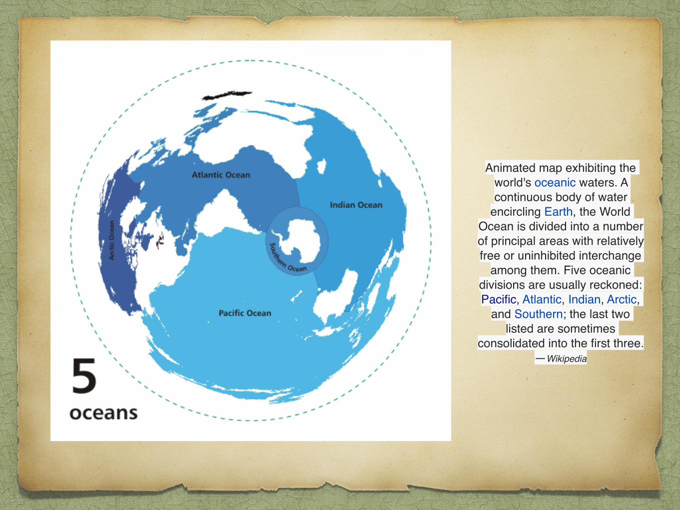
Animated map exhibiting the world's oceanic waters. A continuous body of water
encircling Earth, the World Ocean is divided into a number of principal areas with relatively free or uninhibited interchange
among them. Five oceanic divisions are usually reckoned: Pacific, Atlantic, Indian, Arctic,
and Southern; the last two listed are sometimes
consolidated into the first three.—Wikipedia


The unity and continuity of the World Ocean, with relatively free interchange among its parts, is of fundamental importance to oceanography.[2] It is divided into a number of principal oceanic areas that are delimited by the continents and various oceanographic features: these divisions are the Atlantic Ocean, Arctic Ocean (sometimes considered a sea of the Atlantic), Indian Ocean, Pacific Ocean, and Southern Ocean (often reckoned instead as just the southern portions of the Atlantic, Indian, and Pacific Oceans). In turn, oceanic waters are interspersed by many smaller seas, gulfs, and bays.
A global ocean has existed in one form or another on Earth for eons, and the notion dates back to classical antiquity (in the form of Oceanus).• The contemporary concept of the World Ocean was coined in the early 20th century by the Russian oceanographer Yuly Shokalsky • to refer to what is basically a solitary, continuous ocean that covers and encircles most of Earth.—Wikipedia
Юлий Михайлович Шокальский1856-1940

“Meanwhile there were other significant maritime developments. The hitherto barely charted wastes of the Pacific, still regarded by Spain as her private ocean, were being probed for commercial potential by Britain and France.…
.
Padfield, Supremacy, p. 231.
12
The American Revolution

“Meanwhile there were other significant maritime developments. The hitherto barely charted wastes of the Pacific, still regarded by Spain as her private ocean, were being probed for commercial potential by Britain and France. The first of the recent British expeditions under Commodore John Byron [‘Foul Weather Jack’] • in 1764 also had all the old anti-Spanish aims. It is clear from the First Lord’s report to the Cabinet after Byron had reached the Falkland Islands • en route for the Strait of Magellan:• the Falklands, Egmont stated,were the key to the whole Pacific, commanding ‘the Ports and Trade of Chili Peru [sic], Panama, Acapulco, & in one word all the Spanish territory upon that sea. It will render all our expeditions more lucrative to ourselves, most fatal to Spain.’…
.
Padfield, Supremacy, p. 231.
12
The American Revolution


“Meanwhile there were other significant maritime developments. The hitherto barely charted wastes of the Pacific, still regarded by Spain as her private ocean, were being probed for commercial potential by Britain and France. The first of the recent British expeditions under Commodore John Byron [‘Foul Weather Jack’] • in 1764 also had all the old anti-Spanish aims. It is clear from the First Lord’s report to the Cabinet after Byron had reached the Falkland Islands • en route for the Strait of Magellan:• the Falklands, Egmont stated,were the key to the whole Pacific, commanding ‘the Ports and Trade of Chili Peru [sic], Panama, Acapulco, & in one word all the Spanish territory upon that sea. It will render all our expeditions more lucrative to ourselves, most fatal to Spain.’ “Byron made few discoveries on his Pacific crossing but reported on his return that while sailing through the Tuamotu group (140º W),• he had been convinced of land to the southward and had it not been for unfavorable winds he would probably have found the great unknown southern continent, Terra Australis Incognita, reputed to exist thereabouts.…
.
Padfield, Supremacy, p. 231.
12
The American Revolution


Ortelius, c. 1570

“…exist thereabouts. A second expedition was dispatched in 1766 specifically to seek this continent ‘between Cape Horn and New Zealand, in Latitudes convenient for Navigation, and in Climates adapted to the product of commodities useful in Commerce.’….”
op. cit., p. 232.
12
The American Revolution

“…in Commerce.’ “The same year Choiseul, spurred by the British efforts, dispatched a much grander expedition to the Pacific with ostensibly scientific aims, carrying astronomers and naturalists under the soldier-scholar Antoine de Bougainville….”
op. cit., p. 232.
12
The American Revolution

“…de Bougainville.• Both British and French found to the S of the Tuamotus the ravishing island of Tahiti.• Both were entranced by the spectacular beauty of its peaks and forests,• sparkling beaches, and abundant fruits and flowers, not least by the inhabitants—the men tall and well-proportioned; the young women and girls with hibiscus or jasmine in their dark hair comely beyond imagining and, as soon emerged, happy for sexual relations without shame. For sailors from the colder society of Europe it was paradise found….”
op. cit., p. 232.
12
The American Revolution


Paul Gauguin, c. 1892


Gauguin later wrote a travelogue (first published 1901) titled Noa Noa, originally conceived as commentary on his paintings and describing his experiences in Tahiti. Modern critics have suggested that the contents of the book were in part fantasized and plagiarized. In it he revealed that he had at this time taken a thirteen-year-old girl as native wife or vahine (the Tahitian word for "woman"), a marriage contracted in the course of a single afternoon. This was Teha'amana, called Tehura in the travelogue, who was pregnant by him by the end of summer 1892.—Wikipedia

“…paradise found. “To Bougainville himself the island seemed a Garden of Eden, the life of the populace an idyll of ‘ease, innocent joy, and every appearance of happiness.’ He revised these first impressions on the basis of talks with a native from a chief’s family he carried back to France, who described a rigidly stratified, e v e n t y r a n n i c a l , s o c i e t y practicing human sacrifice • and large-scale infanticide….”
Ibid.
12
The American Revolution

“…large-scale infanticide. But by then his original reports had sparked French intellectuals into rhapsody.• Here was natural man as Rousseau had imagined him [in essays in the 1750s—however, this analogy is faulty]—basically good, uncontaminated by the artifice, prejudice and social constraints of civilization.• Rousseau’s friend the encyclopedist Denis Diderot wrote a Supplement au Voyage de Bougainville which circulated in manuscript, proposing a free and tolerant society modeled on the supposed virtues of the Tahitians and most memorably advocating free love. It was an implied critique of his own country, and was not published until after the French Revolution….”
Ibid.
12
The American Revolution

“…French Revolution. More perceptive were pleas he made for the Pacific to be left unexploited and uncorrupted by Europeans, although in the real world of commercial and national rivalries these were as fantastical as his Utopia.• “Meanwhile the two ships comprising the British expedition arrived home separately. Neither had sighted the great southern continent, but the Swallow under Philip Carteret had made a more southerly passage of the Pacific than any previous European ship and so cut into the area the continent was supposed to occupy….”
op. cit., pp. 232-233.
12
The American Revolution

“…to occupy. It was left to James Cook • in command of the next British expeditions, to establish that it did not exist and in doing so fix the outlines of Pacific geography. “Cook, surely the greatest of all maritime explorers and cartographers, was the son of a laborer from Scotland who had found work on a Yorkshire farm. His early education was paid for by his father’s employer. At eighteen he had gone to sea as an apprentice in east-coast collier barks [three-masted ships with the after-most r igged fo re -and-a f t ] , t each ing h imse l f mathematics [navigation & astronomy]…within six years he had been appointed mate….
op. cit., pp. 232-233.
12
The American Revolution
“…appointed mate. He was offered command soon after, but chose instead to widen his horizon [in 1755 at the build-up for the Seven Years War] by entering the RN as an able seaman. His evident qualities secured his rapid promotion in the non-commissioned ranks, and in the Seven Years War he particularly distinguished himself in sounding and marking the channel up the St Lawrence for the fleet carrying Wolfe’s troops to Quebec. [This charting work would recommend him to the Lords of Admiralty for his next commission]….
op. cit., p. 233.
12
The American Revolution

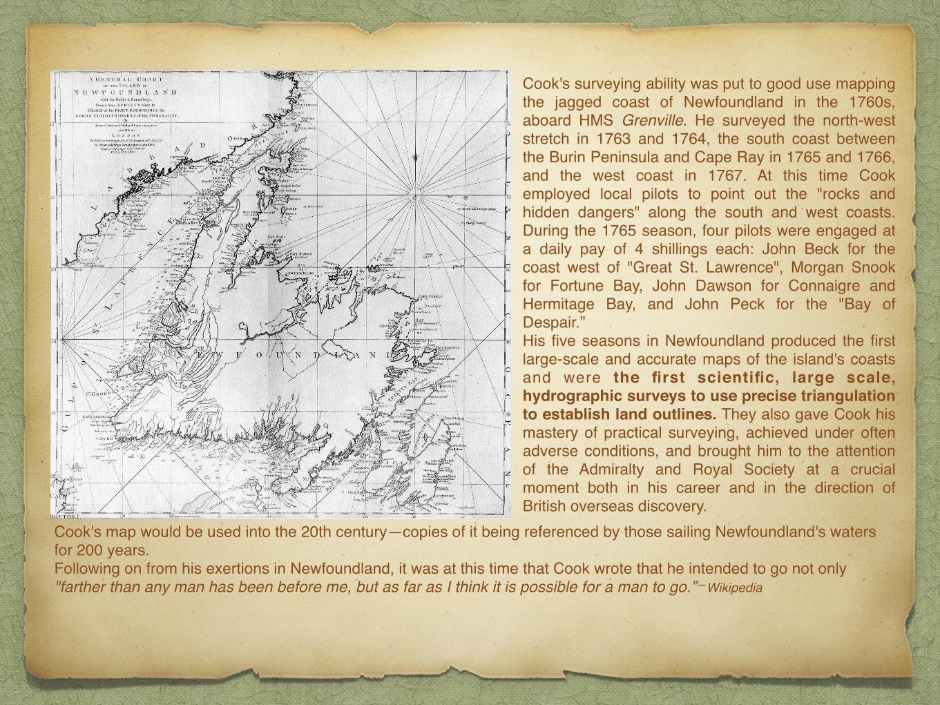
Cook's surveying ability was put to good use mapping the jagged coast of Newfoundland in the 1760s, aboard HMS Grenville. He surveyed the north-west stretch in 1763 and 1764, the south coast between the Burin Peninsula and Cape Ray in 1765 and 1766, and the west coast in 1767. At this time Cook employed local pilots to point out the "rocks and hidden dangers" along the south and west coasts. During the 1765 season, four pilots were engaged at a daily pay of 4 shillings each: John Beck for the coast west of "Great St. Lawrence", Morgan Snook for Fortune Bay, John Dawson for Connaigre and Hermitage Bay, and John Peck for the "Bay of Despair.”His five seasons in Newfoundland produced the first large-scale and accurate maps of the island's coasts and were the first scientific, large scale, hydrographic surveys to use precise triangulation to establish land outlines. They also gave Cook his mastery of practical surveying, achieved under often adverse conditions, and brought him to the attention of the Admiralty and Royal Society at a crucial moment both in his career and in the direction of British overseas discovery.
Cook's map would be used into the 20th century—copies of it being referenced by those sailing Newfoundland's waters for 200 years.Following on from his exertions in Newfoundland, it was at this time that Cook wrote that he intended to go not only "farther than any man has been before me, but as far as I think it is possible for a man to go.”—Wikipedia

[This charting work would recommend him to the Lords of Admiralty for his next commission] It was as a skilled navigator and cartographer that he was chosen in 1768 to command the third British Pacific venture. “This differed from its predecessors in being promoted by the Royal Society, chiefly to participate in an international project to measure the transit of Venus across the sun from widely separated locations across the globe. It was also the first British attempt to study the environment and peoples of Oceania scientifically: a small band of naturalists and artists accompanied the astronomers and Cook was instructed to report on all aspects of the lands he found and to bring back specimens, drawings and surveys. Beyond intellectual inquiry, however, the voyage was viewed from the Cabinet and Admiralty, who provided the ships and crews, as another attempt to find the southern continent and so expand British trade and manufacture into a new hemisphere. The newly discovered island of Tahiti was chosen as the location for observing the transit of Venus, after which Cook was instructed to head S, where ‘there is reason to imagine that a Continent or Land of great extent may be found.’….
Ibid.
12
The American Revolution
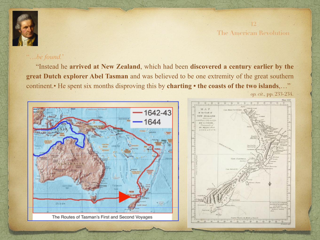
“…be found.’ “Instead he arrived at New Zealand, which had been discovered a century earlier by the great Dutch explorer Abel Tasman and was believed to be one extremity of the great southern continent.• He spent six months disproving this by charting • the coasts of the two islands,…”
op. cit., pp. 233-234.
12
The American Revolution

“…two islands, and thence sailed westward, reaching the south-eastern corner of New Holland—later to be re-named Australia—whose eastern extent was entirely unknown and unexplored.• He raised the Union flag in a capacious inlet just S of a bay which was to become Sydney harbor named the place Botany Bay….”
op. cit., pp. 233-234.
12
The American Revolution

“…Botany Bay after the numerous plants discovered there, then coasted northward, surveying and charting, writing descriptions of the aboriginal inhabitants and extraordinary animal species encountered, marveling at the superabundance of butterflies, and exploring the great barrier reef by boat. Departing finally from the northernmost cape, which he named after the Duke of York, he claimed the whole eastern seaboard for the King, naming it New South Wales.• “Soon after returning to England, he proposed another expedition to clear up the question of the southern continent for good….” op. cit., pp. 233-234.
12
The American Revolution
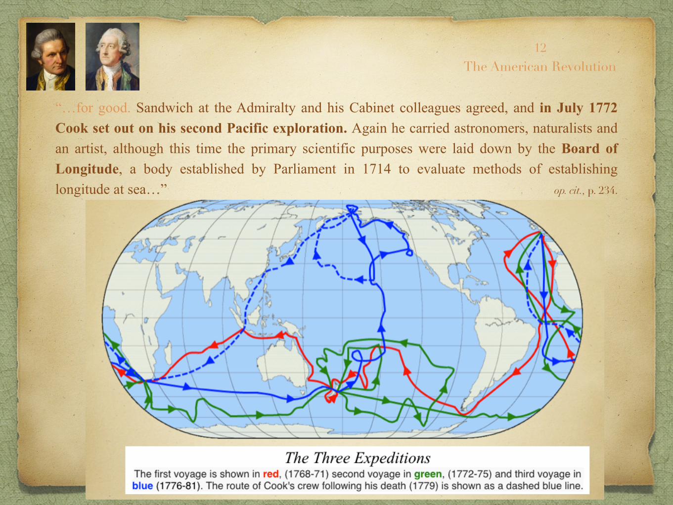
“…for good. Sandwich at the Admiralty and his Cabinet colleagues agreed, and in July 1772 Cook set out on his second Pacific exploration. Again he carried astronomers, naturalists and an artist, although this time the primary scientific purposes were laid down by the Board of Longitude, a body established by Parliament in 1714 to evaluate methods of establishing longitude at sea…” op. cit., p. 234.
12
The American Revolution

LongitudePortrait of John Harrison, English Clockmaker
Thomas King, 1767

Longitude is a geographic coordinate that specifies the east-west position of a point on the Earth's surface. It is an angular measurement, usually expressed in degrees.… Meridians (lines running from the North Pole to the South Pole) connect points with the same longitude. By convention, one of these, the Prime Meridian,• which passes through the Royal Observatory, Greenwich, England…—Wikipedia


Longitude is a geographic coordinate that specifies the east-west position of a point on the Earth's surface. It is an angular measurement, usually expressed in degrees.… Meridians (lines running from the North Pole to the South Pole) connect points with the same longitude. By convention, one of these, the Prime Meridian,• which passes through the Royal Observatory, Greenwich, England,• was allocated the position of zero degrees longitude. The longitude of other places is measured as the angle east or west from the Prime Meridian, ranging from 0° at the Prime Meridian to +180° eastward and −180° westward. Specifically, it is the angle between a plane containing the Prime Meridian and a plane containing the North Pole, South Pole and the location in question.—Wikipedia

The Concept of the Celestial Sphere
Remember Copernicus?• And the geocentric (earth-centered- vs. heliocentric (sun-centered) • concept of the universe? Well, it’s often helpful to revert to the old Ptolemaic earth-centered model to learn about celestial navigation, the only sort possible until the twentieth century.• Navigation is the art of finding your way at sea out of sight of land. When you use landmarks to plot your course at sea, that’s called piloting. But when land drops below the horizon you are left with your compass to choose direction but only the stars to fix your position. The sun can help you determine your latitude (when it’s observable!) Likewise Polaris, the North Star. But longitude is necessary to fix your position with accuracy. And that requires the ability to keep accurate time. But first we will review some basic astronomy and see how the solar system is at the heart of time and position. And for that we need to revisit the pre-Copernican Orbis Caelestium, the celestial sphere.• We need not keep the earth at the center of the universe, but we do need to put the solar system there. Then the stars are seen as “fixed” in a “celestial sphere” which revolves about us in a 24-hour period and through which the sun and planets “pass” through the belt traditionally called the Zodiac which astronomers call the ecliptic plane.
jbp
Celestial Sphere FIRMAMENT

The Earth in its orbit around the Sun causes the Sun to appear on the celestial sphere moving over the ecliptic (red), which is tilted with respect to the equator (blue-white).—Wikipedia

A celestial map from the 17th century, by the Dutch cartographer Frederik de Wit.

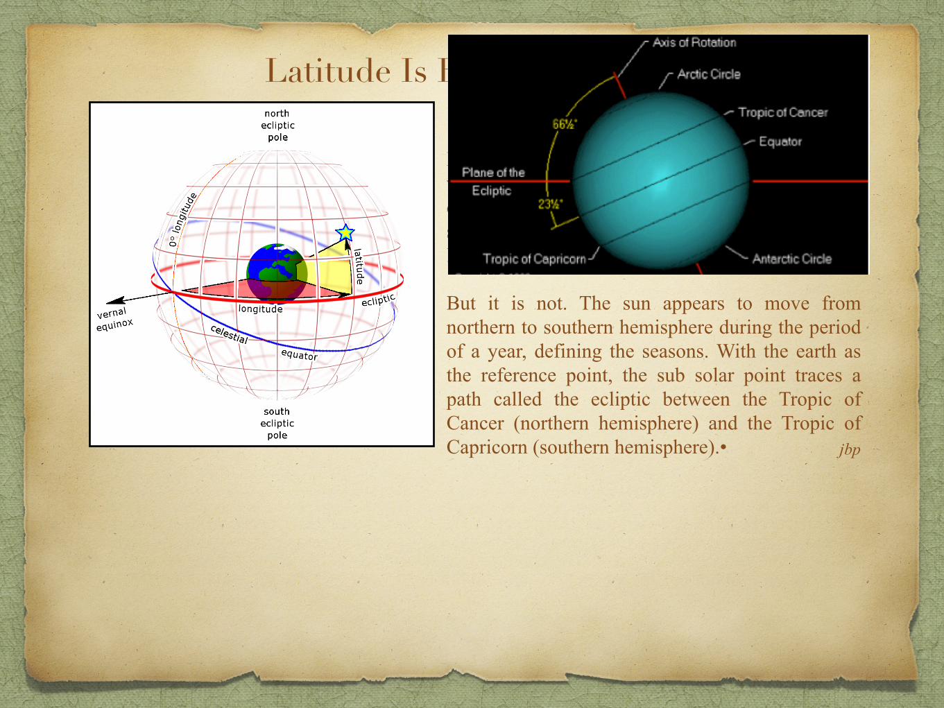
Latitude Is Easily Measured
If the plane defined by the Equator (0º latitude were the same as the plane containing the earth’s orbit around the sun, then latitude would equal the sun’s elevation above the horizon at noon (LMN, local mean noon).•
jbp
Latitude Is Easily Measured
If the plane defined by the Equator (0º latitude were the same as the plane containing the earth’s orbit around the sun, then latitude would equal the sun’s elevation above the horizon at noon (LMN, local mean noon).•
But it is not. The sun appears to move from northern to southern hemisphere during the period of a year, defining the seasons. With the earth as the reference point, the sub solar point traces a path called the ecliptic between the Tropic of Cancer (northern hemisphere) and the Tropic of Capricorn (southern hemisphere).• jbp

Latitude Is Easily Measured
If the plane defined by the Equator (0º latitude were the same as the plane containing the earth’s orbit around the sun, then latitude would equal the sun’s elevation above the horizon at noon (LMN, local mean noon).•
But it is not. The sun appears to move from northern to southern hemisphere during the period of a year, defining the seasons. With the earth as the reference point, the sub solar point traces a path called the ecliptic between the Tropic of Cancer (northern hemisphere) and the Tropic of Capricorn (southern hemisphere).•
Since the sub solar point moves regularly N of the equator at a predictable rate each day from 21 Mar, reaching its highest latitude on the Summer solstice, &c. through the seasons, the latitude of the sub solar point is known. This is called its declination. The angle of the sun above the horizon at LMN can be measured (since antiquity). Thus latitude equals the LMN sun’s elevation plus or minus declination.
jbp

Declination and Right Ascension “In astronomy, declination (abbreviated dec; symbol δ) is one of the two angles that locate a point on the celestial sphere in the equatorial coordinate system, the other being hour angle. Declination's angle is measured north or south of the celestial equator, along the hour circle passing through the point in question.”—Wikipedia
Right ascension (abbreviated RA; symbol α) is the angular distance measured eastward along the celestial equator from the vernal equinox to the hour circle of the point in question.[1] When combined with declination, these astronomical coordinates specify the direction of a point on the celestial sphere in the equatorial coordinate system.—Wikipedia
Clearly, declination is the equivalent of earth latitude in the celestial sphere. And right ascension, or hour angle, corresponds to longitude on earth.
jbp

30º N ship’s position
horizon
30º sun’s elevation
at LMN
At the time of the vernal and autumnal equinoxes, the elevation is identical to the ship’s latitude. At the solstices declination is added or subtracted. For other dates the Nautical Almanac is consulted.
1. As noon approaches the navigator uses his sextant to measure the sun’s lower limb.
2. The rate of ascent in the sky will slow as LMN approaches.
3. When it stops rising and starts to descend the elevation is noted.
At the time of the vernal equinox

Latitude Is Easily Measured with a ‘Sun Shot’ at LMN
Sun’s latitude 0º

Latitude Is Easily Measured with a ‘Sun Shot’ at LMN
Sun’s latitude 23.4 Nº
summer solstice

Sun’s latitude 0º
Latitude Is Easily Measured with a ‘Sun Shot’ at LMN

Latitude Is Easily Measured with a ‘Sun Shot’ at LMN
winter solstice

Now, to the Longitude Problem
The way we conceive of the passage of time is tied to the perceived motion of the sun about the earth. We will see how the time zones are 1/24th of the earth’s circumference, corresponding to the 24 hours into which we divide the day.
This arbitrary system of reckoning goes all the way back to Babylonian (Chaldean) priests who began the western tradition of using the heavens to calculate the calendar as well as the daily timekeeping. When mankind transitioned through the Agricultural Revolution (c. 10,000 BC) there was a need to recon the planting season.
So, now we will make the connection between longitude and time. jbp
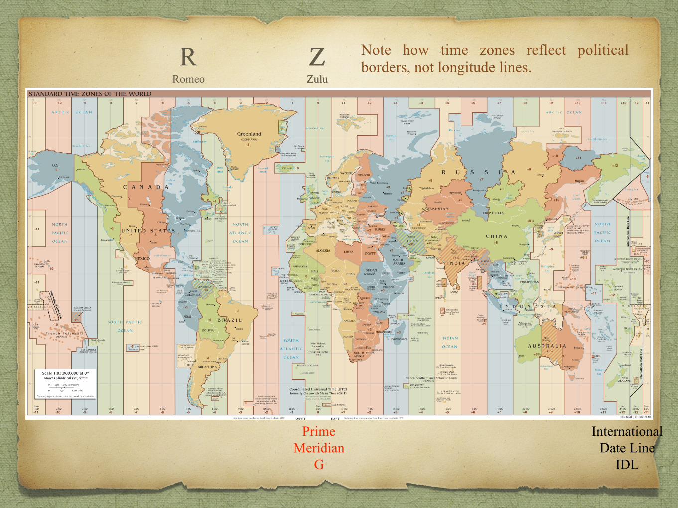
Z Zulu
R Romeo
Z Zulu
Prime Meridian
G
International Date Line
IDL
Note how time zones reflect political borders, not longitude lines.


The International Date Line around the antimeridian (180° longitude)—Wikipedia

A person who goes around the world from east to west (the same direction as Magellan's voyage) would gain or set their clock back one hour for every 15° of longitude crossed, and would gain 24 hours for one circuit of the globe from east to west if they did not compensate by setting their clock forward one day when they crossed the IDL.—Wikipedia

S
G
Z Zulu
-1-2
-3-4
-5
-6
-7
-8-9
-10-11
-12
+1+2
+3+4+5
+6
+7+8
+9+10
+11
GMTN
NovemberO OscarP
Papa
Q Quebec
R Romeo
S Sierra
T TangoU
UniformV Victor W
Whiskey X Xray
A Alpha
C Charlie
B Bravo
D DeltaE
Echo
F Foxtrot
G GolfY
Yoke
L Lima
H HotelI
IndiaK Kilo
M Mike
+12
West Longitude
East Longitude
South Pole

G
Z Zulu
-1-2
-3-4
-5
-6
-7
-8-9
-10-11
-12
+1+2
+3+4+5
+6
+7+8
+9+10
+11
GMTN
NovemberO OscarP
Papa
Q Quebec
R Romeo
S Sierra
T TangoU
UniformV Victor W
Whiskey X Xray
A Alpha
C Charlie
B Bravo
D DeltaE
Echo
F Foxtrot
G GolfY
Yoke
L Lima
H HotelI
IndiaK Kilo
M Mike
+12
West Longitude
East Longitude

S
G
Z Zulu
-1-2
-3-4
-5
-6
-7
-8-9
-10-11
-12
+1+2
+3+4+5
+6
+7+8
+9+10
+11
GMTN
NovemberO OscarP
Papa
Q Quebec
R Romeo
S Sierra
T TangoU
UniformV Victor W
Whiskey X Xray
A Alpha
C Charlie
B Bravo
D DeltaE
Echo
F Foxtrot
G GolfY
Yoke
L Lima
H HotelI
IndiaK Kilo
M Mike
+12
West Longitude
East Longitude
Prime Meridian
G
International Date Line
IDL
South Pole Perceived Solar
Motion
S
GWest Longitude
90º 0’ W
180º 0’
-6
-9-10 12
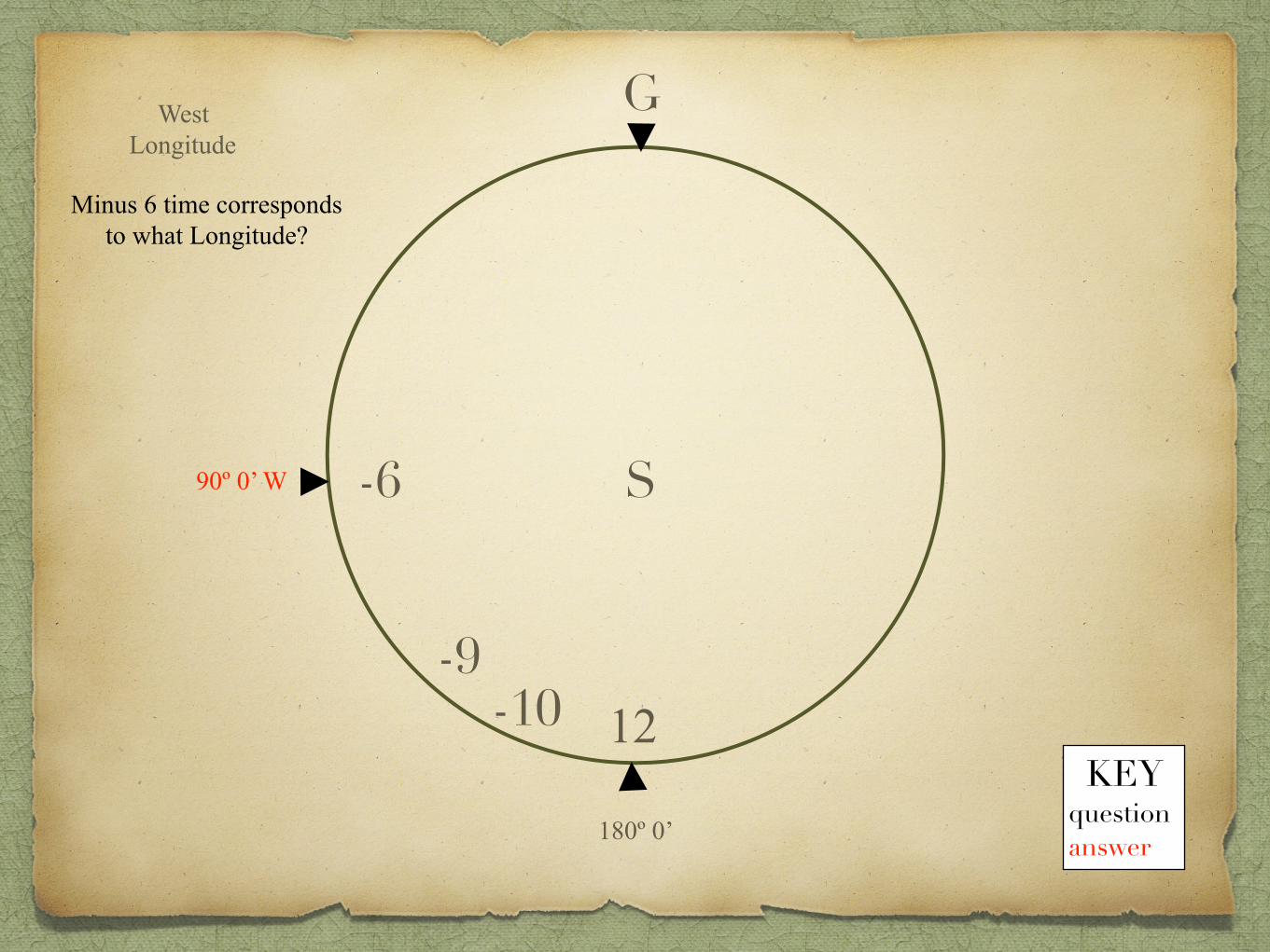
Minus 6 time corresponds to what Longitude?
KEY question answer

S
GWest Longitude
90º 0’ W
180º 0’
-6
-9-10 12
Minus 6 time corresponds to what Longitude?
So how many degrees are in each time zone?
90º ÷ 6 = 15º
KEY question answer

S
GWest Longitude
90º 0’ W
180º 0’
-6
-9-10 12
If it’s Midnight in Greenwich what time (LMT)
is it at 90º W?
6 pm
Minus 6 time corresponds to what Longitude?
If it’s Midnight in Greenwich where’s the sun?
So how many degrees are in each time zone?
90º ÷ 6 = 15º
KEY question answer

S
GWest Longitude
90º 0’ W
180º 0’
-6
135º 0’ W-9
-10150º 0’ W
12
If it’s Midnight in Greenwich what time (LMT)
is it at 90º W?
6 pm
at 135º W?
3 pm
at 150º W?
2 pm
Minus 6 time corresponds to what Longitude?
If it’s Midnight in Greenwich where’s the sun?
So how many degrees are in each time zone?
90º ÷ 6 = 15º
KEY question answer

S
GWest Longitude
180º 0’
-6
-9-10
150º 0’ W
122 pm
If Captain Cook takes a noon sun shot at Tahiti and notes local mean time as 9 hours, 58 minutes and
40 seconds behind Greenwich,• what is Tahiti’s longitude?

S
GWest Longitude
Tahiti 149º25’ W
180º 0’
-10150º 0’ W
122 pm
If Captain Cook takes a noon sun shot at Tahiti and notes local mean time as 9 hours, 58 minutes and
40 seconds behind Greenwich,• what is Tahiti’s longitude?

Cincinnati, OH 39º 6’ N 84º 31’ W(39 degrees 6 minutes North Latitude
84 degrees 31 minutes West Longitude)

19 Greenhouse Ln Oakley
39º8’39” N 84º25’15” W
Bayley Wellness Center
39º8’39” N 84º25’15” W
Cincinnati OH
39º6’ N 84º31’ W
Bayley Wellness Center
39º 5’ 52” N 84º 38’ 30” W

“…the Board of Longitude, a body established by Parliament in 1714 to evaluate methods of establishing longitude at sea and to adjudicate on the award of prize money to anyone who could solve the problem. The very substantial sum of £20,000 had been offered by the government for a method accurate to within half a degree [30’], or 30 nautical miles at the equator. To date no one had won the prize. Remarkably, the shipping supporting the wealth, power and prestige of western Europe was still navigated across the ocean by de’d [deduced] reckoning based on estimates of courses, speeds and drift since the last landfall, combined with the last latitude obtained from observing the angle of the sun above the horizon at noon. “Although no one had earned the full prize money, a clockmaker, John Harrison • had earned it. He was a self-taught natural genius of whose early life little is known beyond the fact that his father was a carpenter from Yorkshire and the movements of his own first clocks were made from oak. Since first hearing about the prize in about 1725 he had worked single-mindedly to construct a timepiece whose accuracy would be unaffected by violent motion or changes in temperature…
Padfield, Supremacy, p. 234.
12
The American Revolution

“…in temperature, so allowing navigators to preserve throughout their voyage an accurate reference time corresponding to the time used in nautical almanacs to record the co-ordinates of heavenly bodies; this would enable them to calculate their position by astronomical observations. The theory was not new, but in practice no clocks were sufficiently accurate or robust. “Harrison’s first ‘sea clock’• had been submitted to the Board of Longitude in 1735, but after sea trials the following year he expressed dissatisfaction with it and was granted funds to make an improved version….”
op. cit., pp. 234-235.
12
The American Revolution

“…i improved version. The improvements occupied him for over two decades and involved the construction of three entirely new types. The final version,• referred to now as H-4—Harrison’s fourth—was a compact watch only 5 ¼ inches in diameter with jeweled pivot holes to eliminate friction in the movement, and, to adjust for climate change, a bimetallic strip of brass and steel riveted together which flexed according to temperature; in so doing it altered the tension of the balance spring. During two sea trials to the WI in 1761-2 and 1764 the watch performed with astonishing accuracy,…”
op. cit., pp. 234-235.
12
The American Revolution


“…astonishing accuracy, allowing the longitude of Barbados to be calculated after a seven-week voyage to within 9.8 miles, thus with three times more accuracy than required for the £20,000 prize. However the Board now added new conditions—to Harrison’s fury—obliging him to explain the secrets of his mechanism so that others could copy the watch, and withholding the full prize money until it was satisfied the system represented ‘a method common and general utility for finding the longitude at sea.’ It was not until Harrison approached King George III, and won his support, that he was granted a bounty by Parliament which brought the receipts for his invention to…some £23,000 if earlier grants from the Board are taken into account….”
op. cit., p. 235.
12
The American Revolution

“…into account. “Meanwhile a professional watchmaker named Larcum Kendall had been commissioned to copy Harrison’s watch. The replica he made—known now as K-1—was entrusted to Cook for sea trials on his second voyage to the Pacific, together with three other marine timekeepers, or chronometers, by another maker. He had carried no chronometers on his first expedition. Besides testing the accuracy of the timepieces, he was instructed to compute his position every day using a rival method of determining longitude by ‘lunar distances,’ measuring the angle between the moon and the sun or particular stars.…” op. cit., p. 235.
12
The American Revolution

In celestial navigation, lunar distance is the angle between the Moon and another celestial body. The lunar distances method uses this angle, also called a lunar, and a nautical almanac to calculate Greenwich time. By comparing that calculated time to the measured local time, the navigator can determine longitude. The method was used for some time during the 18th century, before the introduction of the marine chronometer.—Wikipedia

“…particular stars. He found both methods allowed him to calculate his longitude within a degree and a half, and generally to within half a degree. The problem of longitude was solved, although it was to be over a decade before other clockmakers, inspired by Harrison’s success but using mass-production methods, brought the price of chronometers down to a level navigators could afford; then the far more complex system of lunar distances fell into disuse. While Harrison’s inventive brain and obsessive determination led to the breakthrough to scientific navigation, the contribution of precision instrument makers, mathematicians and astronomers who compiled the tables for the nautical almanacs—the first British edition was in 1767—were crucial as Cook acknowledged in his journal.…”
Ibid.
12
The American Revolution


Diet and DiseaseJames Lind, pioneer in scurvy prevention, performs the first clinical trial
in medical history, 1747

A significant phase of the Enlightenment was the drive to explore and discover new aspects of the natural world. Padfield’s title, Maritime Supremacy & The Opening of the Western Mind, captures this. The quest to observe, examine and classify plant and animal lifeforms was the object of natural history. The modern disciplines of biology, medicine and pharmacology were beginning to employ scientific method, especially observation and experimentation. It is no exaggeration to call Carl von Linné (Carolus Linnaeus) the ‘father of modern taxonomy.’ A tradition of specimen collection (as old as Alexander the Great) was carried on during Cook’s first expedition by Linnaeus’ ‘Apostle,’• Daniel Solander and the great British naturalist,• Sir Joseph Banks. This voyage of discovery also conducted a medical experiment with the utmost significance for sea power.
jbp
Natural History During the Enlightenment


Cook’s First Expedition to OceaniaThe people portrayed are, from left to right, Dr Daniel Solander, Sir Joseph Banks, Captain
James Cook, Dr John Hawkesworth, and John Montagu, 4th Earl of Sandwich.John Hamilton Mortimer, 1771

“One of the human triumphs of Cook’s first voyage had been to bring the ships home without losing a man to scurvy. He accomplished the same remarkable feat on his second voyage. He ascribed it to his insistence, against vigorous complaints, that the men eat sauerkraut—pickled cabbage—on meat days and ‘portable’ (dried) soup on the alternate ‘banyan days,’ and to treating them with ‘wort,’ an infusion of malt which the Navy Board had instructed him to test, directly they showed signs of scurvy. However he also took great care to procure fresh meat and greenstuffs whenever he touched land, which he did frequently, and there is little doubt that it was the wide range of his measures rather than any one that accounted for his success. He seemed to recognize this in his report to the Admiralty, stating that the wort was ‘without doubt one of the best antiscorbutic [an eponym for scurvy] medicines yet discovered,’ but adding, ‘I am not altogether of opinion that it will cure it [scurvy] at sea.’ His surgeons, who failed to make controlled experiments, implied much the same, reporting on the wort as the best remedy fort the cure of scurvy if aided by sago, currants and sauerkraut….
Padfield, Supremacy, pp. 235-236.
12
The American Revolution

“…and sauerkraut. In fact malt has only the faintest trace of ascorbic acid, and these reports, combined with Cooks practical record of keeping his men healthy, had the effect of holding back recognition of a real cure for scurvy, the juice of citrus fruit [cf. ‘Limey’ as slang for Britisher from the later prescription of lime juice for sailors] , for another two decades. “On this second expedition,• which has been described as ‘arguably the greatest, most perfect of all seaborne voyages of discovery,’ Cook reached the Pacific via the Cape of Good Hope and the Indian Ocean, then circled the empty waters between New Zealand and Cape Horn from deep into the Antarctic Circle up to the Tropics, finding and charting islands and island groups but finally disproving the myth of Terra Australis….”
op. cit., p. 236.
12
The American Revolution


ContactHMS Resolution and Discovery in Tahiti
John Cleverly the Younger, 1787-88

“…but finally disproving the myth of Terra Australis. Promoted captain on his return, made a fellow of the Royal Society [FRS]; and lionized by a country in the grip of Pacific fever, he sailed on yet another expedition the following year, 1776, with instructions to solve the last large mystery of the ocean: whether there was an entrance from the N around either America [the NW Passage] or Siberia. It was his final voyage. Again reaching the Pacific by way of the Indian Ocean,…” op. cit., p. 236.
12
The American Revolution

“…but finally disproving the myth of Terra Australis. Promoted captain on his return, made a fellow of the Royal Society [FRS]; and lionized by a country in the grip of Pacific fever, he sailed on yet another expedition the following year, 1776, with instructions to solve the last large mystery of the ocean: whether there was an entrance from the N around either America [the NW Passage] or Siberia. It was his final voyage. Again reaching the Pacific by way of the Indian Ocean, he discovered the Hawaiian Islands [which he named after First Lord Edw Montague, fourth earl of Sandwich] on his way northward, and after surveying the NW American coastline up to 70º, where his passage was barred by impenetrable ice, he returned to Hawaii to refit and provision. There, in Keylakekua Bay on 14 Feb 1779,• he was killed by natives in a dispute over thefts from the ship….”
op. cit., p. 236.
12
The American RevolutionXSandwich Islands

“…but finally disproving the myth of Terra Australis. Promoted captain on his return, made a fellow of the Royal Society [FRS]; and lionized by a country in the grip of Pacific fever, he sailed on yet another expedition the following year, 1776, with instructions to solve the last large mystery of the ocean: whether there was an entrance from the N around either America [the NW Passage] or Siberia. It was his final voyage. Again reaching the Pacific by way of the Indian Ocean,• he discovered the Hawaiian Islands [which he named after First Lord Edw Montague, fourth earl of Sandwich] on his way northward, and after surveying the NW American coastline up to 70º, where his passage was barred by impenetrable ice, he returned to Hawaii to refit and provision. There, in Keylakekua Bay on 14 Feb 1779,• he was killed by natives in a dispute over thefts from the ship. By then this plain, steady Englishman of infinite resource and the cartographic skills of an artist had surpassed all his contemporaries in Pacific exploration and , in Charles Darwin’s phrase, had added a hemisphere to the civilized world.• But it is apparent from his journal entries that,…”
op. cit., p. 236.
12
The American Revolution

“…like Diderot and other French intellectuals who deplored the European impact on the native peoples of America, [Cook] had also seen the other side of the coin and recognized his responsibility for waking the inhabitants of Oceania from a Stone Age slumber to which they could never return….”
Padfield, Supremacy, p. 236.
The Contact Period
12
The American Revolution


The Contact Period The term describes the event when European explorers first meet indigenous people in a much earlier stage of cultural evolution. Recently we have been challenged by anthropologists to avoid regarding the “first peoples” as uncivilized or backward. Though it is hard not to apply the term ‘primitive.’ Think of Columbus and his encounter with the Taino and Carib peoples. Or Leif Erikson and the people he called Skraelings (ancestors of the modern Inuit). Or the 17th century English colonists of Virginia and Massachusetts. A similar contact occurs in Oceania. One of the saddest was the contact between the British convicts taken to Tasmania in 1803 and the aboriginal people living there as hunter-gatherers….
jbp

The Contact Period
“…hunter-gatherers. Transportation, as it was called, began in the seventeenth century in England, to ‘kill two birds with one stone.’ The colonies needed labor and the state needed a new form of punishment—less severe than hanging (there were more than two hundred capital offenses) but still able to (1) serve as a deterrent and to (2) remove dangerous elements from society. When the American Revolution took British North America out of consideration, British criminal justice turned to Cook’s Botany Bay in New South Wales. In 1788 the First Fleet’ took some 1,500 convicts to Australia.*…”
jbp
______ * The convicts had committed a variety of crimes, including theft, perjury, fraud, assault and robbery. The sentences the convicts received were transportation for 7 years, 14 years or for the term of their natural life., Wikipedia.

“…. In 1788 the First Fleet’ took some 1,500 convicts to Australia.* And in 1803 the ‘decent’ colonists convinced the British governor to send the ‘dangerous’ convicts to nearby Tasmania.
jbp
The Contact Period
Tasmania (highlighted in red) is an island state of the Commonwealth of Australia. It is located 150 mi to the south of the Australian mainland, separated by Bass Strait. The state encompasses the main island of
Tasmania, the 26th-largest island in the world, and the surrounding 334 islands.—Wikipedia

The island is believed to have been occupied by Aboriginals for 40,000 years before English colonization. It is thought Tasmanian Aboriginals were separated from mainland Aboriginal groups about 10,000 years ago when the sea rose to form Bass Strait.—Wikipedia

The island is believed to have been occupied by Aboriginals for 40,000 years before English colonization. It is thought Tasmanian Aboriginals were separated from mainland Aboriginal groups about 10,000 years ago when the sea rose to form Bass Strait. The Aboriginal population was estimated to have been between 3000 and 7000 at the time of colonization, but was almost wiped out within 30 years by a combination of violent guerrilla conflict with settlers known as the "Black War", intertribal conflict, and from the late 1820s, the spread of infectious diseases to which they had no immunity. The conflict, which peaked between 1825 and 1831 and led to more than three years of martial law, cost the lives of almost 1100 Aboriginals and settlers. The near-destruction of Tasmania's Aboriginal population has been described by some historians as an act of genocide by the British.The state was created in 1803 as a penal settlement of the British Empire to prevent claims to the land by the First French Empire during the Napoleonic Wars; around 75,000 convicts were sent to Van Diemen's Land before transportation ceased in 1853. The state was initially a territory of New South Wales and was independently established as a self-governing colony under the name Van Diemen's Land (named after Anthony van Diemen•) in 1825. —Wikipedia


Extinction of the Tasmanian Aborigines
Geoffrey Blainey* wrote that by 1830 in Tasmania: "Disease had killed most of them but warfare and private violence had also been devastating." Other historians regard the Black War as one of the earliest recorded modern genocides. Benjamin Madley wrote: "Despite over 170 years of debate over who or what was responsible for this near-extinction, no consensus exists on its origins, process, or whether or not it was genocide. However, "[using the] UN definition, sufficient evidence exists to designate the Tasmanian catastrophe genocide."
Wikipedia______ * Geoffrey Blainey (1930- ) “…most controversial of Australia’s living historians….coined the phrase ‘black armband view of history,’ during the History Wars” — Wikipedia.

Extinction of the Tasmanian Aborigines
By 1833, Christian missionary George Augustus Robinson, sponsored by Lieutenant Governor George Arthur, had persuaded the approximately 200 surviving Aboriginal Tasmanians to surrender themselves with assurances that they would be protected, provided for and eventually have their lands returned to them. These 'assurances' were in fact lies – promises made to the survivors that played on their desperate hopes for reunification with lost family and community members. The assurances were given by Robinson solely to remove the Aboriginal people from mainland Van Diemen's Land. The survivors were moved to Wybalenna Aboriginal Establishment on Flinders Island,… —Wikipedia

Extinction of the Tasmanian Aborigines
“…Flinders Island,• where diseases continued to reduce their numbers even further. In 1847, the last 47 living inhabitants of Wybalenna were transferred to Oyster Cove, south of Hobart. Two individuals, Truganini • (1812–1876) and Fanny Cochrane Smith (1834–1905), are separately considered to have been the last people solely of Tasmanian descent. —Wikipedia

A Hauntingly Sad Conclusion to the Tasmanian Contact
Truganini’s life spanned almost the entire period which witnessed her people’s extinction (unintended genocide?). She was born the daughter of the Bruny Island people’s chief and took part in her people’s traditional culture until the invasion. Both the convicts after 1803 and settlers like George Robinson began to impinge on the traditional hunting lands of the several thousand Tasmanian aborigines. One of the ‘black armband historians’ remarks that some of the worst convicts began by raping the native women and then hunting and killing aborigines, regardless of age or sex, for mere sport. Naturally, retaliation killings of the European settlers followed in a period called the Black Wars. When Truganini met George Robinson in 1829, “her mother had been killed by sailors, her uncle shot by a soldier, her sister abducted by sealers, and her fiancé brutally murdered by timber-cutters, who then repeatedly sexually abused her. In 1830, Robinson, moved Truganini and Woorrady to Flinders Island with the last surviving Tasmanian Aborigines, numbering approximately 100. The stated aim of isolation was to save them, but many of the group died from influenza and other diseases. In 1838 Truganini also helped Robinson to establish a settlement for mainland Aborigines at Port Phillip.”* She became disillusioned with the flawed projects and became a ‘bush ranger’ (Australian for highwayman) robbing and murdering. In 1842 she was captured and escaped hanging but was sent back to another aboriginal reservation. As her death approached, she begged the authorities to not put her body on display in a museum as had happened to the last male Tasmanian aborigine. To no avail. Only on the centennial of her death were her remains cremated and buried at sea in accordance with her wishes.
jbp ______ * Wikipedia.

Copper Sheathing

op. cit., pp. 236-237.
“…waking the inhabitants of Oceania from a Stone Age slumber to which they could never return. “The settlement of New South Wales, Australia and New Zealand as British colonies would follow. Before then the British navy made an important advance unconnected with Pacific discovery: the sheathing of ships hulls with copper as protection against Teredo [Teredo navalis, Linnaeus, 1758] boring worms in tropical waters. Copper had first come into wide use for this purpose in the early years of the century as new methods of smelting metals, stimulated in England by the wars of Louis XIV, had allowed the production of copper sheet in commercial quantities. By the late 1720s copper sheathing was required by London insurers for merchant vessels trading to West Africa and the Indies. Unfortunately the copper induced severe corrosion of iron hull and rudder fastenings—due to electrolytic action, which was not then well understood—and the practice was abandoned. “As the WI rose to strategic prominence during the Seven Years War the Admiralty looked at the problem anew, first having the keel of a frigate sheathed with copper, then sheathing three vessels completely….”
12
The American Revolution

“…vessels completely. The results were astonishing: not only were the coppered craft impervious to the boring worm, their underwater hulls remained clean and bright and free from marine growth—they not only sailed faster than their non-coppered and encrusted sisters but did not need such frequent docking [or careening] for cleaning. Nevertheless the corrosion of the hull ironwork was alarming. As a consequence,• in 1768 Hawke’s Board ordered an experimental sloop built with all underwater fastenings of forged copper instead of iron. This was to prove a satisfactory but expensive solution to the problem. In the meantime the succeeding Board • under Sandwich began experimenting with waterproofed brown paper laid over the underwater hull timbers before the copper was applied. The Navy Board controller, the executive head of the dockyards, quickly convinced himself the method was sound, as a result of which in 1778 Sandwich took the extraordinarily bold decision to copper the entire fleet in this way. In terms of ship maintenance it was a huge and costly mistake, as the brown paper did not provide a sufficient seal and after a while ships began literally to fall apart. In strategic terms it was the wrong decision at precisely the right time: in the short term, before the hulls disintegrated, it provided a superiority in speed, ship for ship, that allowed the RN to survive a period of dangerous numerical inferiority to the combined Bourbon battle fleet.”
op. cit., p. 237.
12
The American Revolution

Thus Padfield concludes his series of “other significant maritime developments”:
Now we return to the political, diplomatic, military side of the Enlightenment. France decides to put her thumb on the scales of British North America’s struggle for independence. Will her navy be able to temporarily wrest command of the seas from Britain? Wear down the war party in Parliament so that the peace party composed by such luminaries as Burke and Fox can put an end to this fratricidal war?
But that’s another story… jbp
• Cook’s remarkable opening of the Pacific • the solution of the longitude problem • ending the scourge of scurvy • the impact on native peoples of contact with Western settlers • sleeker hulls


Fin


