SDD English v.7 - The Field Museumfm2.fieldmuseum.org/rbi/temp/Sierra_del_Divisor_English.pdf ·...
96
PERÚ: SIERRA DEL DIVISOR DICIEMBRE/DECEMBER 2006 121 ENGLISH CONTENTS (for Color Plates, see pages 23–38) 122 Participants 124 Institutional Profiles 128 Acknowledgments 130 Mission 131 Report at a Glance 140 Why Sierra del Divisor? 141 Conservation of the Sierra del Divisor 141 Current Status 143 Conservation Targets 146 Threats 147 Recommendations 153 Opportunities 155 Technical Report 155 Regional Overview and Inventory Sites 160 Geology and Hydrology 163 Flora and Vegetation 173 Fishes 182 Amphibians and Reptiles 186 Birds 196 Mammals 204 Sociocultural Assets for Conservation 210 Legal Status of Territorial Reserves 217 Appendices 218 (1) Geology 219 (2) Vascular Plants 248 (3) Hydrology 249 (4) Fish Sampling Stations 250 (5) Fishes 258 (6) Amphibians and Reptiles 263 (7) Birds 274 (8) Large Mammals 280 (9) Regional Mammal Inventories 283 (10) Bats 285 (11) Human Settlements 286 (12) Social Assets 292 Literature Cited 298 Previous Reports
Transcript of SDD English v.7 - The Field Museumfm2.fieldmuseum.org/rbi/temp/Sierra_del_Divisor_English.pdf ·...

PERÚ: SIERRA DEL DIVISOR DICIEMBRE / DECEMBER 2006 121
ENGLISH CONTENTS
(for Color Plates, see pages 23–38)
122 Participants
124 Institutional Profiles
128 Acknowledgments
130 Mission
131 Report at a Glance
140 Why Sierra del Divisor?
141 Conservation of the Sierra del Divisor141 Current Status
143 Conservation Targets
146 Threats
147 Recommendations
153 Opportunities
155 Technical Report155 Regional Overview and Inventory Sites
160 Geology and Hydrology
163 Flora and Vegetation
173 Fishes
182 Amphibians and Reptiles
186 Birds
196 Mammals
204 Sociocultural Assets for Conservation
210 Legal Status of Territorial Reserves
217 Appendices218 (1) Geology
219 (2) Vascular Plants
248 (3) Hydrology
249 (4) Fish Sampling Stations
250 (5) Fishes
258 (6) Amphibians and Reptiles
263 (7) Birds
274 (8) Large Mammals
280 (9) Regional Mammal Inventories
283 (10) Bats
285 (11) Human Settlements
286 (12) Social Assets
292 Literature Cited
298 Previous Reports

Christian Albujar (birds)
Instituto de Investigación de Enfermedades Tropicales
Virology Program, U.S. Naval Medical Research
Center Detachment
Lima, Peru
Moisés Barbosa da Souza (amphibians and reptiles)
Universidade Federal do Acre
Rio Branco, Brazil
Nállarett Dávila Cardozo (plants)
Universidad Nacional de la Amazonía Peruana
Iquitos, Peru
Francisco Estremadoyro (logistics)
ProNaturaleza
Lima, Peru
Robin B. Foster (plants)
Environmental and Conservation Programs
The Field Museum, Chicago, IL, USA
Thomas Hayden (journalist)
U.S. News and World Report
Washington, DC, USA
Max H. Hidalgo (fishes)
Museo de Historia Natural
Universidad Nacional Mayor de San Marcos
Lima, Peru
Dario Hurtado (transport logistics)
Policía Nacional del Perú
Lima, Peru
Maria Luisa S. P. Jorge (mammals)
University of Illinois – Chicago
Chicago, IL, USA
Guillermo Knell (amphibians and reptiles, field logistics)
Environmental and Conservation Programs
The Field Museum, Chicago, IL, USA
Presila Maynas (social assessment)
Federación de Comunidades Nativas del Alto Ucayali
Pucallpa, Peru
Italo Mesones (plants)
Universidad Nacional de la Amazonía Peruana
Iquitos, Peru
Orlando Mori (social assessment)
Federación de Comunidades Nativas del Bajo Ucayali
Iquitos, Peru
Debra K. Moskovits (coordinator)
Environment, Culture, and Conservation
The Field Museum, Chicago, IL, USA
Andrea Nogués (social assessment)
Center for Cultural Understanding and Change
The Field Museum, Chicago, IL, USA
José F. Pezzi da Silva (fishes)
Pontifícia Universidade Católica do Rio Grande do Sul
Porto Alegre, Brazil
Renzo Piana (social assessment)
Instituto del Bien Común
Lima, Peru
Carlos Rivera (amphibians and reptiles)
Universidad Nacional de la Amazonía Peruana
Iquitos, Peru
José-Ignacio (Pepe) Rojas Moscoso (field logistics, birds)
Rainforest Expeditions
Tambopata, Peru
122 RAPID BIOLOGICAL INVENTORIES INFORME / REPORT NO. 17
PARTICIPANTS
FIELD TEAM

Thomas S. Schulenberg (birds)
Environmental and Conservation Programs
The Field Museum, Chicago, IL, USA
Jaime Semizo (social assessment)
Instituto del Bien Común
Lima, Peru
Robert Stallard (geology)
Smithsonian Tropical Research Institute
Panama City, Panama
Vera Lis Uliana Rodrigues (plants)
Universidade de São Paulo
São Paulo, Brazil
Raúl Vásquez (social assessment)
ProNaturaleza
Pucallpa, Peru
Claudia Vega (logistics)
The Nature Conservancy-Peru
Lima, Peru
Paúl M. Velazco (mammals)
Division of Mammals
The Field Museum, Chicago, IL, USA
Corine Vriesendorp (plants)
Environmental and Conservation Programs
The Field Museum, Chicago, IL, USA
Asociación Interétnica de Desarrollo de la Selva Peruana(AIDESEP)Lima, Peru
Centro de Datos para la Conservación (CDC)Lima, Peru
Centro de Investigación y Manejo de Áreas Naturales (CIMA)Lima, Peru
Derecho, Ambiente y Recursos Naturales (DAR)Lima, Peru
Federación de Comunidades Nativas del Alto Ucayali (FECONAU)Pucallpa, Peru
Federación de Comunidades Nativas del Bajo Ucayali (FECONBU)Iquitos, Peru
Fuerza Aérea del Perú (FAP)Lima, Peru
Gobierno Regional de Loreto (GOREL)Iquitos, Peru
Gobierno Regional de Ucayali (GOREU)Pucallpa, Peru
Instituto Nacional de Recursos Naturales (INRENA)Lima, Peru
Policía Nacional del Perú (PNP)Lima, Peru
Universidade Federal do Acre (UFAC)Rio Branco, Brazil
Pontifícia Universidade Católica do Rio Grande do Sul (PUCRS)Porto Alegre, Brazil
PERÚ: SIERRA DEL DIVISOR DICIEMBRE / DECEMBER 2006 123
COLLABORATORS

124 RAPID BIOLOGICAL INVENTORIES INFORME / REPORT NO. 17
INSTITUTIONAL PROFILES
The Field Museum
The Field Museum is a collections-based research and
educational institution devoted to natural and cultural diversity.
Combining the fields of Anthropology, Botany, Geology, Zoology,
and Conservation Biology, museum scientists research issues in
evolution, environmental biology, and cultural anthropology.
One division of the museum—Environment, Culture, and
Conservation (ECCo)—through its two departments, Environmental
and Conservation Programs (ECP) and the Center for Cultural
Understanding and Change (CCUC), is dedicated to translating
science into action that creates and supports lasting conservation
of biological and cultural diversity. ECCo works closely with local
communities to ensure their involvement in conservation through
their existing cultural values and organizational strengths. With
losses of natural diversity accelerating worldwide, ECCo’s mission
is to direct the museum’s resources—scientific expertise, worldwide
collections, innovative education programs—to the immediate
needs of conservation at local, national, and international levels.
The Field Museum
1400 South Lake Shore Drive
Chicago, Illinois 60605-2496 U.S.A.
312.922.9410 tel
www.fieldmuseum.org
The Nature Conservancy – Peru
The Nature Conservancy is an international non-profit
organization, founded in 1951. It is headquartered in the United
States, but also works in more than 30 other countries around the
world. The mission of The Nature Conservancy is to preserve the
plants, animals and natural communities that represent the
diversity of life on Earth by protecting the lands and waters they
need to survive. The Nature Conservancy’s vision is to conserve
portfolios of functional conservation areas within and across
ecoregions. In Peru, TNC has three main initiatives: Pacaya
Samiria National Park, the forests of the Selva Central, as well
as creating a protected area in the Sierra del Divisor region that
is a sister conservation area to the Serra do Divisor National Park
across the Brazilian border.
The Nature Conservancy – Peru
Av. Libertadores 744, San Isidro
Lima, Peru
51.1.222.8600 tel
51.1.221.6243 fax
www.nature.org /wherewework/southamerica /peru
INSTITUTIONAL PROFILES

ProNaturaleza – Fundación Peruana para la Conservación de la Naturaleza
ProNaturaleza— the Fundación Peruana para la Conservación de
la Naturaleza is a non-profit organization, created in 1984 with
the purpose of contributing to the conservation of the natural
patrimony of Peru, with particular emphasis on its biodiversity, the
promotion of sustainable development, and the betterment of the
quality of life of the Peruvian people. In order to achieve these
goals, ProNaturaleza executes projects, primarily in natural areas,
along three principal lines: the protection of biological diversity,
the sustainable use of the natural resources and the promotion of
a culture of conservation in the national society.
ProNaturaleza – Fundación Peruana para la
Conservación de la Naturaleza
Av. Alberto del Campo 417
Lima 17, Peru
51.1.264.2736, 51.1.264.2759 tel
51.1.264.2753 fax
www.pronaturaleza.org
Insituto del Bien Común (IBC)
The Instituto del Bien Común is a Peruvian non-profit organization
devoted to promoting the best use of shared resources. Sharing
resources is the key to our common well-being today and in the
future, as a people and as a country; to the well-being of the large
number of Peruvians who live in rural areas, in forests and on the
coasts; to the long-term health of the natural resources that sustain
us; and to the sustainability and quality of urban life at all social
levels. IBC is currently working on four projects: the Pro Pachitea
project, which focuses on local management of fish and aquatic
ecosystems; the Indigenous Community Mapping project, which
aims to defend indigenous territories; and the Large Landscapes
Management Program, which aims to the creation of a mosaic of
sustainable use and protected areas in the Ampiyacu, Apayacu,
Yaguas and Putumayo rivers. The mosaic will be constituted by the
enlargement of communal lands, a system of regional conservation
areas and a national protected area. We are also promoting the
participation of indigenous organizations in the creation and
categorization of the Zona Reservada Sierra del Divisor. The IBC
recently completed the ACRI project, a study of how communities
manage natural resources, and distributed the results in a number
of publications.
Instituto del Bien Común
Av. Petit Thouars 4377
Miraflores, Lima 18, Peru
51.1.421.7579 tel
51.1.440.0006 tel
51.1.440.6688 fax
www.ibcperu.org
PERÚ: SIERRA DEL DIVISOR DICIEMBRE / DECEMBER 2006 125

126 RAPID BIOLOGICAL INVENTORIES INFORME / REPORT NO. 17
Organizacion Regional AIDESEP–Iquitos (ORAI)
The Regional Organization AIDESEP-Iquitos (ORAI) is
registered publicly in Iquitos, Loreto. This institution consists
of 13 indigenous federations, and represents 16 ethnic groups
located along the Putumayo, Algodón, Ampiyacu, Amazonas,
Nanay, Tigre, Corrientes, Marañón, Samiria, Ucayali, Yavarí and
Tapiche Rivers in the Loreto region.
The mission of ORAI is to ensure communal rights, to protect
indigenous lands, and to promote an autonomous economic
development based on the values and traditional knowledge that
characterize indigenous society. In addition, ORAI works on
gender issues, developing activities that promote more balanced
roles and motivate the participation of women in the communal
organization. ORAI actively participates in land titling of native
communities, as well as in working groups with governmental
institutions and the civil society for the development and
conservation of the natural resources in the Loreto region.
Organización Regional AIDESEP–Iquitos
Avenida del Ejercito 1718
Iquitos, Peru
51.65.265045 tel
51.65.265140 fax
Organizacion Regional AIDESEP–Ucayali (ORAU)
The Organización Regional AIDESEP–Ucayali (ORAU) is
registered publicly in Pucallpa, Peru. The institution brings
together 12 indigenous federations representing 14 ethnic groups
and includes 398 titled native communicites and 48 on the road
to formal land titles. The majority of these communities are
situated in the Ucayali, Pachitea, Yurúa and Purus watersheds,
as well as the Gran Pajonal.
ORAU’s mission is to promote the territorial rights of indigenous
people, to strengthen bilingual intercultural education via the
Atalaya pilot project, and—as part of the Universidad Nacional
Indigena de la Amazonia Peruana—to protect indigenous health
and value traditional medicine.
ORAU participates in developing community forest
management plans, in managing the Reserva Comunal El Sira via
the Eco Sira project, in managing the Reserva Territorial del Purus,
and in representing indigenous interests in the working group for
Zona Reservada Sierra del Divisor /Siná Jonibaon Manán.
Organización Regional AIDESEP–Ucayali
Jr. Aguarico 170
Pucallpa, Peru
51.61.573469 tel
INSTITUTIONAL PROFILES

PERÚ: SIERRA DEL DIVISOR DICIEMBRE / DECEMBER 2006 127
Herbario Amazonense de la Universidad Nacional de la Amazonía Peruana
The Herbario Amazonense (AMAZ) is situated in Iquitos, Peru,
and forms part of the Universidad Nacional de la Amazonía
Peruana (UNAP). It was founded in 1972 as an educational and
research institution focused on the flora of the Peruvian Amazon.
In addition to housing collections from several countries, the
bulk of the collections consists of specimens representing the
Amazonian flora of Peru, considered one of the most diverse floras
on the planet. These collections serve as a valuable resource for
understanding the classification, distribution, phenology, and
habitat preferences of ferns, gymnosperms, and angiosperms.
Local and international students, docents, and researchers use
these collections to learn, identify, teach, and study the flora.
In this way the Herbario Amazonense contributes to the
conservation of the diverse Amazonian flora.
Herbarium Amazonense (AMAZ)
Esquina Pevas con Nanay s /n
Iquitos, Peru
51.65.222649 tel
Museo de Historia Natural de la Universidad Nacional Mayor de San Marcos
Founded in 1918, the Museo de Historia Natural is the
principal source of information on the Peruvian flora and fauna.
Its permanent exhibits are visited each year by 50,000 students,
while its scientific collections—housing a million and a half
plant, bird, mammal, fish, amphibian, reptile, fossil, and mineral
specimens—are an invaluable resource for hundreds of Peruvian
and foreign researchers. The museum’s mission is to be a center
of conservation, education and research on Peru’s biodiversity.
It highlights Peru’s status as one of the most biologically diverse
countries on the planet, and that its economic progress depends
on the conservation and sustainable use of its natural riches.
The museum is part of the Universidad Nacional Mayor de
San Marcos, founded in 1551.
Museo de Historia Natural de la Universidad Nacional
Mayor de San Marcos
Avenida Arenales 1256
Lince, Lima 11, Peru
51.1.471.0117 tel
www.museohn.unmsm.edu.pe

128 RAPID BIOLOGICAL INVENTORIES INFORME / REPORT NO. 17
A rapid biological inventory is successful only with the support
and energy of many collaborators and partners. We are grateful to
everyone who made our work possible, and although we cannot
acknowledge each and every individual, we sincerely appreciate the
assistance that we received from all.
Members of our advance team—headed by Guillermo Knell,
with the close collaboration of Italo Mesones and José-Ignacio
“Pepe” Rojas—deserve enormous credit for their superb
management of the complicated logistics of the inventory. They
received invaluable support in Contamana, the initial staging
point, from Wacho Aguirre of CIMA-Contamana. Other key
assistance was provided by Carmen Bianchi and Antuanett
Pacheco, of Kantu Tours; Max Rivera, of ProNaturaleza-Pucallpa;
and the Hostal August in Contamana. Ruben Ruiz, of the Hotel
Ruiz in Pucallpa, graciously accommodated our crew both before
and after the field work, and provided perfect facilities for the
preparation of our initial reports.
We continue to be deeply indebted to the Peruvian
National Police for their indispensable support and assistance
with helicopter transport. The intricate logistical details of our
movements from site to site were overseen carefully, as always,
by Commander Dario Hurtado. We also are grateful to Captain
Jhony Herencia Calampa (pilot), Roger Conislla (mechanic), and
Julio Sarango (supplier). Jaime Paredes Lopez helped coordinate
our flights by small plane from Pucallpa to Contamana.
The advance team showed wonderful creativity and
determination in entering this remote wilderness, identifying
suitable terrain for fieldwork, and preparing heliports,
comfortable field camps, and trail networks. The advance team
at Ojo de Contaya, led by Italo Mesones, included Edgar Caimata
Payahua, Luis Edilberto Chanchari Panduro, Juan Alberto Díaz
Ocampo, Elmergildo Gómez Huaya, Samuel Paredes Tananta,
Freddy Astolfo Pezo Cauper, Euclides Rodríguez Acho,
Hector Rodríguez Mori, Albertano Saboya Romaina, and Moisés
Tapayuri Urquia. Our camp on the banks of the Río Tapiche was
established by Pepe Rojas, with Ambrosio Acho Mori, Manuel
Ilande Cachique Dasilva, Jarbis Jay Flores Shuña, Jimy Angel Mori
Amaringo, Elmo Enrique Ramírez Guerrero, Medardo Rodríguez
Sanancino, Orlando Ruiz Trigoso, Fernando Valera Vela,
Luis Fernando Vargas Tafur, and Limber Vásquez Mori. The
advance team at Divisor was led by Guillermo Knell and also
included Kherry Marden Barrantes Tuesta, Hernando Benjamin
Cauper Magin, Santiago Dasouza Ríos, Hornero Miguel Díaz
Ocampo, Wilmer Gómez Huaya, Ezequiel Meléndez Pinedo,
Golber Missly Coral, Demetrio Rengifo Cordova, Josue Rengifo
Córdova, and Romer Romaina Vásquez. Our cook, Betty Luzcita
Ruiz Torres, kept us well fed at each of our camps.
The botanical team is grateful to Fabio Casado and to
the Herbario Amazonense for providing a site for the drying
and organizing of the field collections. We also are grateful
to M.L. Kawasaki (The Field Museum) for assistance with
identifications of Myrtaceae; and to the following colleagues from
The Missouri Botanical Garden: T. Croat (Araceae), G. Davidse
(Cyperaceae, Poaceae), R. Ortiz-Gentry (Menispermaceae),
J. Ricketson (Myrsinaceae), C. Taylor (Rubiaceae), and
H. van der Werff (Lauraceae).
The ichthyology team thanks Hernán Ortega for his review
of their report, and to members of the advance team at each
camp for their help with fish capture. For help in identifying
specimens (especially of Loricariidae) we thank Roberto E. Reis
and Pablo Lehmann.
The herpetology team acknowledges Dr. Alejandro Antonio
Duarte Fonseca for comments on the report, and is grateful to
Dr. Lily O. Rodríguez for indispensable help in Lima and for the
invaluable loan of sound recording equipment. We also thank
our field assistants: Moisés Tapayuri, Fernando Valera,
Ambrosio Acho, and Golber Missly.
The ornithologists thank David Oren (The Nature Conservancy)
and Bret Whitney for providing valuable information on the results
of the inventories of the Parque Nacional da Serra do Divisor;
Doug Stotz and Dan Lane for constructive comments on the report
and for assistance in identifying sound recordings; and Bil Alverson
for suggesting the field use of an iPod.
The mammal team is very grateful to Idea Wild for the
donation of the two camera traps that were used during the
inventory; to Carlos Peres and Mark Bowler for comments on the
report; to the Department of Zoology (Bird Division) at The Field
Museum for the loan of mist nets; and to our field assistants,
Albertano Saboya, Fernando Valera, Demetrio Rengifo, and
Josue Rengifo.
The social inventory team also received assistance from a
considerable number of people during the course of their
ACKNOWLEDGMENTS
PERÚ: SIERRA DEL DIVISOR DICIEMBRE / DECEMBER 2006 129
fieldwork. We would like to thank Javier Orlando Rodríguez
Chávez, a forestry specialist from ProNaturaleza, who
accompanied us during some of our surveys, and the following
boat crews: Segundo Mozombite, Santiago Rojas Mendoza, and
Álvaro Vásquez Flores. Robert Guimaraes and Gilmer Yuimachi
(of ORAU) and Edwin Vásquez (of ORAI) facilitated our contacts
with communities in the Divisor region. We also are grateful for
the assistance and hospitality of the members of the communities
that we visited, including Flores Rafael Fuchs Ruiz (the head of
Comunidad Nativa San Mateo) and other members of this
community (Rafael Fuchs Pérez, Melisa Emeli Fuchs Pérez,
Jobita Ruiz López, Carlos Vásquez, and Walter Soria Sinarahua);
Rita Silvano Sánchez, of C.N. Callería; Domingo Padilla and
Nardita Reina Lomas, of Comunidad Campesina Bella Vista;
the Teniente Gobernador of C.C. Nuevo Canelos; Hugo Andrés
Vega Tarazona (the Teniente Gobernador) and other members of
Caserío Vista Alegre (Francisco Ayzana Alanya, Winder Vela Pacaya,
and Nilo Ruiz Vela); Sixto Vásquez Papa (Teniente Gobernador)
and Magali Trejos Villanueva, of Caserío Guacamayo;
Germán Mori Rojas, the head of the C.N. Patria Nueva;
Jairo Rengifo Pinedo, Agente Municipal of the C.N. Limón Cocha;
Guillermo Alvarado Acho (the leader), Pedro Pacaya Tamani
(Teniente Gobernador), and Luis Acho Alvarado (Agente Municipal)
of the C.N. Canchahuaya. We also thank Alaka Wali for her
oversight of the social team process and for her comments on
our report.
We thank Mark Bowler for the use of his photographs,
Guillermo Knell for his superb video documentation of the
inventory, and Nigel Pitman for allowing us to use his prose in
“Why Sierra del Divisor?”
Tyana Wachter, Rob McMillan, and Brandy Pawlak
assisted at every stage, from the initial organization before our
departure to the inventory itself through the completion and
dissemination of this report. Sergio Rabiela prepared the satellite
images. Dan Brinkmeier, Kevin Havener, and Nathan Strait
prepared beautiful maps and visual materials that were critical to
communicating about our work. Lucia Ruiz helped us tremendously
by editing the chapter on the legal situation of the territorial
reserves. Brandy Pawlak, Tyana Wachter, and Doug Stotz, as
always, were master copyeditors and proofreaders. We also had
the assistance of a talented pool of translators: Patricia Álvarez,
Malu S. P. Jorge, Pepe Rojas, Susan Fansler Donoghue,
Tyana Wachter, Paúl M. Velazco, and Amanda Zidek-Vanega.
Jim Costello and his staff at Costello Communications continue
to display great skill (and patience) in overseeing the design and
production of this report.
We are grateful to the Gordon and Betty Moore Foundation
for the financial support of this inventory.

130 RAPID BIOLOGICAL INVENTORIES INFORME / REPORT NO. 17
MISSION
During rapid biological inventories, scientific teams focus primarily
on groups of organisms that indicate habitat type and condition
and that can be surveyed quickly and accurately. These inventories
do not attempt to produce an exhaustive list of species or higher
taxa. Rather, the rapid surveys 1) identify the important biological
communities in the site or region of interest, and 2) determine
whether these communities are of outstanding quality and
significance in a regional or global context.
During social asset inventories, scientists and local
communities collaborate to identify patterns of social organization
and opportunities for capacity building. The teams use participant
observation and semi-structured interviews to evaluate quickly the
assets of these communities that can serve as points of engagement
for long-term participation in conservation.
In-country scientists are central to the field teams. The
experience of local experts is crucial for understanding areas with
little or no history of scientific exploration. After the inventories,
protection of natural communities and engagement of social
networks rely on initiatives from host-country scientists and
conservationists.
Once these rapid inventories have been completed (typically
within a month), the teams relay the survey information to local
and international decisionmakers who set priorities and guide
conservation action in the host country.
The goal of rapid biological and social inventories is tocatalyze effective action for conservation in threatenedregions of high biological diversity and uniqueness.
Approach

PERÚ: SIERRA DEL DIVISOR DICIEMBRE / DECEMBER 2006 131
Dates of fieldwork 6–24 August 2005
Region Sierra del Divisor—known by its indigenous residents as Siná Jonibaon Manán,
or “Land of the Brave People”—is a mountain range that rises up dramatically
from the lowlands of central Amazonian Peru (Fig. 2A). This band of mountains
runs roughly north to south and straddles the Peru–Brazil border.
To the west of the Sierra del Divisor lies the Serranía de Contamana (Fig. 2A),
which forms a narrow arc near the small town of Contamana. East of the Serranía
de Contamana sits a remote, eye-shaped ring of ridges and valleys known as the
Ojo de Contaya. Finally, to the south of the Sierra del Divisor, an isolated set of
volcanic cones jut out of the lowlands (Figs. 1, 2A, 2B).
Within central Amazonian Peru, the Sierra del Divisor is part of a series of
low mountains that forms a broken chain extending from near the banks of the
Río Ucayali eastward to the border with Brazil (Figs. 2A, 2B). The region lies
mostly within the department of Loreto, but also stretches into the northernmost
section of the department of Ucayali.
Collectively, the entire complex of mountains—Sierra del Divisor, Serranía de
Contamana, Ojo de Contaya, and the volcanic cones—is known as the Sierra del
Divisor /Siná Jonibaon Manán Region. Zona Reservada Sierra del Divisor (which
was established after our inventory) comprises this same region (Fig. 2A).
Biological Inventory Sites The biological team surveyed three sites within Zona Reservada Sierra del Divisor
(the “Zona Reservada,” Figs. 3A, 3B). The first was near the center of the Ojo
de Contaya complex (Ojo de Contaya, Fig. 3A). The second was along the upper
Río Tapiche, in the lowlands adjacent to the Sierra del Divisor (Tapiche, Fig. 3B).
The third was within the Sierra del Divisor itself, near the border with Brazil
(Divisor, Fig. 3B).
Organisms Studied Vascular plants, fishes, amphibians and reptiles, birds, medium to large
mammals, and bats.
Social Inventory Sites The social team visited 9 of the 20 communities situated in and around
the Zona Reservada (Fig. 2A), in four different drainages: the Río Abujao
(C.N. San Mateo), the Río Callería (C.N. Callería, C.N. Patria Nueva, Guacamayo,
Vista Alegre), the Río Tapiche (C. N. Limon Cocha, Bella Vista), and the Río
Ucayali (C. N. Canchahuaya, Canelos).
Social focus Cultural and social assets, including organizational strengths, and resource use
and management.
R E P O R T AT A G L A N C E

132 RAPID BIOLOGICAL INVENTORIES INFORME / REPORT NO. 17
One of the most remarkable features of the Zona Reservada is the high
concentration of rare and range-restricted species. Several of these species are
known only from this region and occur in restricted habitats (e.g., the stunted
forests on tops of sandy ridges).
Our inventory documented:
01 A bird species (Figs. 7C, 7D) previously known only from one ridge in
Brazil, adjacent to the Zona Reservada; our record during the inventory was
the second anywhere and the first in Peru.
02 A large community of primates, including species globally threatened or not
previously protected within the Peruvian park system (SINANPE) (Figs. 8A, 8D).
03 Refuges of plant and animal species threatened elsewhere in the Amazon
with commercial overexploitation and extinction.
04 Several dozen species of plants, fishes, and amphibians potentially new to
science, as detailed below.
The number of rare and endemic species in the region is spectacular, even
though, compared to other sites in Amazonia, the species richness itself may not
be extraordinary (Table 1). Below we highlight some of our most interesting
findings, including the discovery of species not previously known to science or
reported from Peru, important range extensions of poorly known species, and
discovery of substantial populations of threatened species.
R E P O R T AT A G L A N C E
Highlights of
biological results
Table 1. Number of species registered and estimated in Zona Reservada Sierra del Divisor.
* We did not visit the sites in the region typical of Amazonian lowland forest, where expected
numbers of species are high but expected endemism is low, but we include the richer
Amazonian sites in our estimates of total species richness.
Vascular Amphibians LargeInventory site plants Fishes and reptiles Birds mammals
Ojo de Contaya 500 20 29 149 23
Tapiche 750 94 40 327 31
Divisor 600 24 32 180 18
Total for inventory over 1,000 109 109 365 38
Estimate for theZona Reservada* 3,000–3,500 250–300 over 200 570 64

PERÚ: SIERRA DEL DIVISOR DICIEMBRE / DECEMBER 2006 133
Vascular plants: We recorded nearly 1,000 species of the 2,000 predicted to
occur in the central and eastern portions of the Sierra del Divisor Region. All
sites we visited during the inventory were on sandy soils with low productivity.
When richer soils (present in areas north and south of the sites that we visited)
are taken into account, we estimate a flora of 3,000–3,500 species for the region.
At least ten species of plants encountered during the inventory are new to science,
including several new trees. Among these are a miniature Parkia (Fabaceae)
previously known only from photographs taken in Cordillera Azul, a national park
in the Andean foothills ca. 675 km to the west. An abundant species in the
stunted forests at Ojo de Contaya and Divisor appears to be a new species of
Pseudolmedia or Perebea (Moraceae). In addition, two tree species in the
Clusiaceae, a Moronobea and a Calophyllum (Fig. 4J), also potentially are new.
We found the majority of rare and/or new species in the stunted forests that
dominate the ridge tops of the Ojo de Contaya and Divisor sites. We recorded
reproductive individuals of several species of commercially valuable trees, such
as cedro (Cedrela sp.) and tornillo (Cedrelinga cateniformis ), that increasingly
are threatened in other parts of Peru.
Fishes: We recorded 109 species of fishes during the inventory, and estimate
that 250–300 species occur within the Zona Reservada. At least 14 species of
fish found during the inventory are new to science or are new records for Peru.
Fish species richness varied considerably from site to site. At the Tapiche camp
(located on a major river and encompassing a variety of aquatic habitats), we
recorded 94 species, whereas the low-productivity streams in Ojo de Contaya
and Divisor harbored 20 and 24 species, respectively.
We recorded a variety of economically important fishes along the Tapiche,
including fishes important for downstream human communities, such as sábalos
(Brycon spp. and Salminus), boquichico (Prochilodus nigricans), lisa (Leporinus
friderici ), and tigre zúngaro (Pseudoplatystoma tigrinum, Fig. 5D), as well as
ornamental fishes, such as glass fish (Leptagoniates steindachneri , Fig. 5B),
lisas (Abramites hypselonotus), and a Peckoltia sp. (carachama, Fig. 5A).
Amphibians and reptiles: We recorded 109 species during the inventory,
including 68 amphibians and 41 reptiles. Fourteen of these species (12% of
the total number of species encountered) remain unidentified. Several of these
probably are species new to science, including an unidentified species of
Eleutherodactylus frog at the Divisor camp. Apart from a single species of
salamander, all of the amphibians were frogs and toads. We registered 21

134 RAPID BIOLOGICAL INVENTORIES INFORME / REPORT NO. 17
snakes, 17 lizards, 2 turtles, and 1 caiman. At least two species are new
records for Peru: a frog, Osteocephalus subtilis, found at both Ojo de Contaya
and Divisor, and a coral snake, Micrurus albicinctus (Fig. 6E), found at Tapiche
that represents a new venomous snake species for Peru.
Birds: We recorded 365 bird species in the three inventory sites. We estimate
that 570 bird species occur in the Zona Reservada, including the avifauna
predicted to occur in sites with richer soils in the northern and southern portions
of the region. We registered several rare and patchily distributed species
associated with forests on sandy soils, such as Rufous Potoo (Nyctibius
bracteatus, Fig. 7A) and Fiery Topaz (Topaza pyra).
Our most outstanding record was the Acre Antshrike (Thamnophilus divisorius,
Figs. 7C, 7D), which we found in the stunted ridge-crests forests at Ojo de
Contaya and Divisor. This species previously was known from a single ridge in
Brazil; our inventory indicates that the bulk of its population occurs within Peru.
Along the Tapiche we recorded various endangered and/or threatened species
including Blue-headed Macaw (Primolius couloni ) and large numbers of various
tinamou species. We encountered game birds (guans, Penelope; and curassows,
Mitu) at all of our three sites. We were surprised to register an Oilbird (Steatornis
caripensis) at the Divisor camp. Unexpected in Amazonia because they roost and
breed in caves, it seems likely that small colonies of Oilbird live in the caves of
the Sierra del Divisor mountains.
Mammals: We recorded 38 species of medium and large mammals during the
inventory, almost two-thirds of the 64 species we estimate for the entire region.
Of these, 20 species are considered threatened by the IUCN, CITES, or INRENA.
The majority are primates: we found 13 species of marmosets and monkeys, with
12 species present at a single site (Tapiche)—a remarkable species richness
for primates in the western Amazon.
Among the primates, two species are especially rare and poorly known: Goeldi’s
marmoset (Callimico goeldii , Fig. 8D) and red uakari monkeys (Cacajao calvus,
Fig. 8A). This is the first protected area in Peru in which both species occur.
We found sizeable populations of several widespread large monkeys that are
commonly hunted, such as black spider monkey (Ateles chamek) and common
woolly monkey (Lagothrix poeppigii ). We also found two other species vulnerable
to hunting: the giant armadillo (Priodontes maximus) and the South American
tapir (Tapirus terrestris).
R E P O R T AT A G L A N C E
Highlights of
biological results
(continued)

PERÚ: SIERRA DEL DIVISOR DICIEMBRE / DECEMBER 2006 135
Human Communities and Highlights of Social Inventory: Voluntarily isolated
Iskonawa live in the southeastern portion of the Divisor region, within the Reserva
Territorial (R.T.) Isconahua1, a 275,665-ha area established in 1998. Two additional
Reservas Teritoriales2 (Yavarí-Tapiche and Kapanawa) have been proposed, but not
established, in the northern and western portions of the region (Fig. 10B).
Several temporary camps have been established for larger-scale resource extraction
in the north (logging along the Río Tapiche, Fig. 9A) as well as in the south
(timber and mining concessions overlapping with the R.T. Isconahua) (Fig. 9B).
Otherwise, human presence within most of the Zona Reservada appears to be
minimal, with a few temporary dwellings established along rivers for small-scale
resource extraction (e.g., medicinal plants, hunting, and fishing).
At least 20 communities—including indigenous people, many of whom have
been resident for generations, and more recently arrived colonists—live adjacent
to the Zona Reservada (Fig. 2A). Members of these communities depend on
subsistence agriculture and low-impact use of natural resources (Fig. 11A).
Resource extraction is largely for household consumption, although in some
communities there is a small amount of commerce based on forest products.
These neighboring communities value their forest-based lifestyle, which they
perceive as threatened by outsiders and by large-scale, commercial, extractive
industries (Fig 9B). Several communities have organized themselves to promote
local, sustainable practices of resource use.
Main threats The main threats stem from large-scale extractive industries: logging, mining,
and oil exploration (Fig 9B). Pervasive logging in Amazonia poses an enormous
threat to populations of the most commercially valuable timber species, often
leading to local extinctions. There are proposed logging concessions in the north
that overlap with the Zona Reservada and with the proposed Reserva Territorial
Yavarí -Tapiche. Illegal logging is active even in the heart of the Zona Reservada
(Fig. 9B). In the west and south, mining and oil exploration proposals ring the
borders of the Zona Reservada, and in several places overlap with the Reserva
Territorial Isconahua.
Other threats come from over-exploitation of wildlife. Illegal, commercial fishing
is a concern for communities living around the edges of the Zona Reservada,
especially in the north and south. On the upper Río Tapiche, we encountered eight
species of fishes that are an important part of the Amazonian fisheries, including
1 Peruvian indigenous organizations use the spelling “Iskonawa,” but the official name of the territorial reserve is “Isconahua.”
2 Territorial reserves are now known as Reservas Indigenas in Peru, per a new law concerning areas designated for voluntarilyisolated indigenous peoples (Law No. 28736, 2006; see chapter about the legal status of the territorial reserves).

136 RAPID BIOLOGICAL INVENTORIES INFORME / REPORT NO. 17
scaly fishes such as Brycon spp. and Salminus (sábalos), Prochilodus
nigricans (boquichico), Leporinus friderici (lisa), and large catfishes, such as
Pseudoplatystoma tigrinum (tigre zúngaro, Fig. 5D). These species were relatively
abundant. Many of them migrate seasonally to the headwaters to spawn. The
Zona Reservada may prove to be crucial in the life cycle of these fish species,
which are important to the livelihoods of human communities living downstream.
Also on the Río Tapiche, we found populations of two species of Amazonian
turtles, Podocnemis unifilis (taricaya) and Geochelone denticulata, that are eaten
by local people.
Birds that are hunted throughout Amazonia, such as curassows (Mitu tuberosum)
and guans (Penelope jacquacu), were present at all three sites we sampled.
Impressive quantities of tinamous were observed at Tapiche. We observed a
small flock of Blue-headed Macaws (Primolius couloni ) at the Tapiche camp.
This species is almost entirely restricted to Peru, with a few sightings from
immediately adjacent portions of Brazil and Bolivia, and was recently listed as
endangered by BirdLife International.
We recorded 20 species of medium and large mammals that are considered
threatened by IUCN, CITIES, or INRENA; 13 are primates. Some species are
listed for their ecological rarity (Goeldi’s monkey, Callimico goeldii, Fig. 8D;
red uakari monkey, Cacajao calvus, Fig. 8A), and others because they experience
heavy hunting pressure throughout Amazonia (e.g., South American tapir, Tapirus
terrestris; giant armadillo, Priodontes maximus). We regularly encountered several
monkey species that are hunted throughout their range and are among the first
primate species to face local extinction (black spider monkey, Ateles chamek; and
common woolly monkey, Lagothrix poeppigii ).
Current status Upon leaving the field in August 2005, we immediately formed the Sierra
del Divisor /Siná Jonibaon Manán Work Group. Composed of indigenous and
conservation organizations dedicated to the region, the Work Group is focused on
creating a united front of participating institutions to overcome the overwhelming
threats to the region and to provide, as quickly as possible, strict and effective
protection both to the indigenous groups in voluntary isolation and to the
biological and geological treasures in the region.
The consensus-building effort resulted in the joint indigenous-conservationist
request for Zona Reservada Sierra de Divisor, which was established on
11 April 2006 (Resolución Ministerial 0283-2006-AG; 1.48 million hectares;
Fig. 2A). Protected status was our most urgent recommendation as we left the
field, given the magnitude and intensity of the threats to the region. This joint
R E P O R T AT A G L A N C E
Main threats
(continued)

PERÚ: SIERRA DEL DIVISOR DICIEMBRE / DECEMBER 2006 137
request for Zona Reservada came with the explicit understanding that the Work
Group is committed to developing a strong, consensus recommendation for the
final categorization of the Zona Reservada, to be presented and worked through
with INRENA’s official Categorization Committee (Comisión de Categorización).
01 Implement effective protection of Zona Reservada Sierra del Divisor.
Protection of the Zona Reservada is urgent. Accelerating fragmentation of
the region by roads, mining, oil exploration, and development constitutes an
irreversible threat (Fig. 9B). Immediate and effective protection is crucial for
the survival of indigenous peoples living in voluntary isolation as well as for
the unique biological and geological conservation targets in the region.
02 Develop strong consensus for the final categorization and eventual zoning of
Sierra del Divisor/Siná Jonibaon Manán. The joint request from indigenous and
conservation organizations to Peru’s president, to grant immediate protection to
Sierra del Divisor through the category of “Zona Reservada,” came with the
explicit understanding that Zona Reservada is a provisional category. The next
step is for the Sierra del Divisor Work Group to analyze priority sites for
indigenous and conservation groups and to develop suitable recommendations
for the official Categorization Committee (Comisión de Categorización)
established by INRENA.
The latest map of priorities, as discussed in the Work Group meeting of 5
December 2006 (Fig. 10C), leads us to the preliminary recommendation of a
complex of protected areas composed of two Territorial Reserves neighboring a
National Park (Fig 10D). Our guiding vision is full support from both indigenous
and conservation organizations for the final categorization.
03 Anchor the protection and management of the Sierra del Divisor /Siná
Jonibaon Manán Region on a solid collaboration among indigenous federations,
local villages, and conservation organizations. All are crucial for successful
protection of this threatened and unique landscape.
04 Strengthen the legal mechanisms to offer solid protection to indigenous people
living in voluntarily isolation. Until recently, Reserva Territorial was the category
assigned to lands with indigenous peoples living in voluntary isolation. However,
the category lacked a strong legal backing (as is shown in Sierra del Divisor,
where mining concessions were granted in the heart of the Reserva Territorial
Isconahua). The Sierra del Divisor/Siná Jonibaon Manán Work Group joined
others in pursuing a law that would protect voluntarily isolated indigenous
peoples. The law, passed in 2006, still needs substantial modifications to afford
Principalrecommendations for protection and management

138 RAPID BIOLOGICAL INVENTORIES INFORME / REPORT NO. 17
adequate protection. Revising and strengthening this legal framework is a vital
next step for the protection of uncontacted indigenous peoples throughout Peru.
05 Rescind the mining concessions that overlap with the Reserva Territorial
Isconahua. The presence of mining activities directly contradicts the purpose
of the Reserva Territorial, putting at risk the health and livelihood of
indigenous people living in voluntary isolation (Fig. 9B).
06 Adjust the borders of the Zona Reservada to exclude the villages along the
Río Callería and in Orellana (as shown in Fig. 2A, 10C). These communities
should not be included within a protected area.
07 Collaborate with local communities to develop locally based protection and
management plans. Communities bordering the Zona Reservada strongly
support protection for the area and its resources.
08 Establish areas of strict protection to protect the voluntarily isolated peoples.
In close collaboration with the indigenous organizations, assign the highest
category of protection to the portions of the Zona Reservada where indigenous
peoples are believed to live in isolation. If ever these indigenous peoples opt
for contact with civilization, appropriate studies must be conducted to
determine the actual size of the lands to be titled in their names.
09 Involve the Matsés in the zoning, management, and stewardship of
the northernmost section of the Zona Reservada (Fig. 2A, 10C, 10D).
This section of Amazonian lowlands is used by indigenous Matsés communities
(Vriesendorp et al. 2006) and they are the natural stewards of these lands.
01 The area’s geological and climatic diversity are unique in Amazonia. The
resulting high levels of biodiversity and endemism make Sierra del Divisor
one of the highest conservation priorities in Peru.
02 The new Zona Reservada is contiguous with the 1.49-million-hectare Parque
Nacional da Serra do Divisor and several other protected areas just across the
border in Brazil, creating a binational conservation corridor that stretches from
the Río Amazonas in the north to the Río Madre de Dios in the south. The
western border of the Zona Reservada is nearly contiguous with the Parque
Nacional Cordillera Azul, linking these isolated mountains to the main body
of the Andes (Fig. 2B).
03 There currently are few people within the limits of the Zona Reservada.
Careful categorization and zoning of the area, in cooperation with leaders of
R E P O R T AT A G L A N C E
Principal recommendations
(continued)
Long-term conservation benefits

PERÚ: SIERRA DEL DIVISOR DICIEMBRE / DECEMBER 2006 139
indigenous organizations, will respect the territorial rights of indigenous
peoples in voluntary isolation.
04 The area’s scenic beauty and natural riches will be a major tourist attraction
for Ucayali and Loreto. Special attractions include hot springs (where hundreds
of macaws congregate for the mineral-rich water), volcanic massifs rising out of
lowland forest, and 13 species of primates.

140 RAPID BIOLOGICAL INVENTORIES INFORME / REPORT NO. 17
Why Sierra del Divisor?
Rocky towers rise like exclamation marks over the surrounding lowlands.
A hot, sulfurous spring bubbles up from deep underground and the mist swarms
with Scarlet Macaws attracted to minerals in the water. A great expanse of sandstone
mesas and ridges, cut off from the rest of the world, stands unexplored in the endless
Amazonian lowlands.
This is Sierra del Divisor, locally called Siná Jonibaon Manán, a complex
of isolated mountains set like gems in Peru’s Amazonian lowlands. Nowhere else in
Amazonia is there comparable diversity of geology and climate. The jumble of ancient
rock formations rising up in the midst of younger formations catch thunderstorms
coming off the Amazonian plains. In the resulting mosaic of rain shadows, tall humid
forests stand side by side with severely stunted shrublands. And many yet-to-be-
described organisms, occurring here and nowhere else, live alongside the distinct flora
and fauna that biologists already have registered.
Future alternatives for these forests are stark. Unless a unified, concerted
group of people take effective action now, the loggers and miners working in and
around the region will further invade and dissect its forests. This fragmentation
will profoundly impoverish the unique plant and animal communities of the region,
and catastrophically endanger its indigenous populations.
The new Zona Reservada creates a binational conservation expanse and
an enormous conservation opportunity that is contiguous with a million-hectare
conservation complex in Brazil (including the Parque Nacional da Serra do Divisor,
Fig. 2A). Protection and successful stewardship of Sierra del Divisor will set an
example of collaboration between two different constituencies—the conservation
organizations and the indigenous communities—that will serve as a model to
strengthen the protection of both the environment and traditional cultures in Peru.
PERÚ: SIERRA DEL DIVISOR DICIEMBRE / DECEMBER 2006 141
The Sierra del Divisor /Siná Jonibaon Manán Region encompasses a jumble of
overlapping proposals by conservation groups, indigenous peoples, and large-
scale commercial enterprises. Immediately after we returned from the inventory
in August 2005, we formed the Sierra del Divisor /Siná Jonibaon Manán Work
Group to resolve several of these conflicting proposals and to build a strong
consensus for effective protection of the area. Composed of the indigenous and
conservation organizations dedicated to the region, members of the Work Group
include the Organización Regional de AIDESEP–Iquitos (ORAI), Organización
Regional de AIDESEP–Ucayali (ORAU), Asociación Interétnica de Desarrollo de
la Selva Peruana (AIDESEP), The Nature Conservancy–Peru (TNC),
Pronaturaleza, Instituto del Bien Común (IBC), Derecho, Ambiente y Recursos
Naturales (DAR), Centro de Investigación y Manejo de Áreas Naturales (CIMA),
Sociedad Peruana de Derechos Ambientales (SPDA), Centro para el Desarrollo
del Indígena Amazónico (CEDIA), Centro de Datos para la Conservación (CDC),
and The Field Museum.
After a constructive year of joint efforts, the central goals of the Work Group
remain (1) joining forces of the participating institutions to surmount the
relentless threats to the region (mining, oil, illegal logging, lack of legal backing
for Reservas Territoriales) and (2) developing viable mechanisms, as quickly as
possible, to provide strict protection for the indigenous groups in voluntary
isolation and the biological and geological treasures in the region. The Work Group
devoted itself to working simultaneously on building a strong consensus proposal
for safeguarding Sierra del Divisor /Siná Jonibaon Manán while strengthening the
legal status of Reserva Territorial. We formed working subgroups and continue
to meet regularly.
Our joint effort succeeded in the consensus indigenous-conservationist request
for Zona Reservada Sierra de Divisor, which was established on 11 April 2006
(Resolución Ministerial 0283-2006-AG; 1.48 million hectares; Fig. 2A).
Protected status through a Zona Reservada was our most urgent recommendation
given the magnitude and intensity of the threats to the region. The joint request
for Zona Reservada—a provisional designation within the Peruvian national
CURRENT STATUS
Conservation of the Sierra del Divisor

142 RAPID BIOLOGICAL INVENTORIES INFORME / REPORT NO. 17
protected areas system (SINANPE)—came with the explicit understanding that
the Work Group committed itself to building a consensus recommendation for
the final categorization of the Zona Reservada, encompassing the indigenous and
conservation visions, to be presented and worked through with INRENA’s official
Categorization Committee (Comisión de Categorización).
The Zona Reservada currently encompasses the Reserva Territorial (“R.T.”)
Isconahua (275,665 ha; Fig. 2A). The R.T. Isconahua was established to protect
the rights and livelihoods of voluntarily isolated Iskonawa. Reserva Territorial is a
designation outside the purview of SINANPE and is administered by national
indigenous institutions (AIDESEP and INDEPA). There are two additional
proposals for Reserva Territorial status in Sierra del Divisor: the proposed R.T.
Kapanawa (504,448 ha) lies in the central and western parts of the Zona
Reservada, while the proposed R.T. Yavarí-Tapiche (1,058,200 ha) partially
overlaps the northern portion of the Zona Reservada.
The large-scale commercial enterprises in the region vary from proposed to
established concessions. Some mining concessions, approved in 2004, are
operational in the heart of the R.T. Isconahua. While none of the five oil
concessions have yet been granted, all overlap partially with the Zona Reservada.
Logging concessions in the north along the Tapiche drainage already are
established and operational.
In December 2006, the Work Group requested that INRENA postpone its
decision for final categorization of the Zona Reservada by four months to April
2007. The additional time will allow for crucial workshops in the region and
gathering of data necessary for a consensus proposal for categorization. The
recent joint map of conservation and indigenous priority areas, as discussed
in the Work Group meeting of 5 December 2006, appears here as Figure 10C.
The map does not yet include the priorities of ORAI and still needs additional
input to reach full consensus.
Current Status (continued)

PERÚ: SIERRA DEL DIVISOR DICIEMBRE / DECEMBER 2006 143
The following species, forest types, biological communities, and ecosystems
are of particular conservation concern in Zona Reservada Sierra del Divisor.
Some of the conservation targets are important because they are unique; rare,
threatened, or vulnerable elsewhere in Peru; key resources for the local economy;
or Amazonia; or fulfill crucial roles in the function of the ecosystem.
CONSERVATION TARGETS
� Vast stretches of intact forest that form a corridor in
Peru with Parque Nacional Cordillera Azul to the west,
the proposed Reserva Comunal Matsés to the north,
and in Brazil with the Parque Nacional da Serra do
Divisor to the east (Figs. 2A, 2B)
� Rare and diverse geological formations that occur
nowhere else in Amazonia and include a series of
sandstone ridges in the west (Serrania de Contamana,
Ojo de Contaya) and east (Sierra del Divisor), and
volcanic cones in the south (El Cono) (Figs. 2A, 2B)
� A glorious mosaic of soil types: rich, high-diversity
soils in the north; poor-to-intermediate fertility soils
that harbor endemics in the central portion of the area;
and volcanic soils in the south
� Headwaters of the upper Río Tapiche, which are
crucial for the migration and reproduction of fish
species (including commercially important ones), and
the headwaters of at least ten other rivers that
originate in the region
� Streams that drain soils of poor-to-intermediate fertility
and may represent important speciation centers for
various fishes
� Stunted forests on poor soils occurring principally on
hill crests (Figs. 3H, 3I)
Biological Communities

144 RAPID BIOLOGICAL INVENTORIES INFORME / REPORT NO. 17
� Populations of timber species (such as Cedrela sp. and
Cedrelinga cateniformis) that are logged at unsustainable
levels elsewhere in Amazonia
� Species endemic to habitats unique to the region,
including several species new to science growing on
sandstone ridges (Parkia, Aparisthmium, Fig. 4C)
� Species of Hemigrammus, Hemibrycon, Knodus, and
Trichomycterus (Fig. 5E) that are present in remote
streams and likely restricted to the region
� Species of Cheirodontinae present in the Río Tapiche and
principal tributaries, including Ancistrus, Cetopsorhamdia
(Fig. 5C), Crossoloricaria, and Nannoptopoma, which are
probably restricted to the region
� Species of importance for fisheries that represent signifi-
cant sources of protein for local human communities, such
as Pseudoplatystoma tigrinum (Fig. 5D), Brycon spp., a
Salminus sp., Prochilodus nigricans, and a Leporinus sp.
� Ornamental species of Cichlidae, Gasteropelecidae,
Loricariidae, Anostomidae, and Characidae with commercial
value and susceptible to overharvesting
� Unique fish communities in the aquatic environments
of Ojo de Contaya
� Species of economic value (turtles, tortoises, and caiman)
that are threatened in other parts of their distributions
� Rare species that represent new records for Peru
(Osteocephalus subtilis and Micrurus albicinctus, Fig. 6E)
� Amphibian communities that reproduce and develop in
forest and stream environments (Centrolene, Cochranella,
Hyalinobatrachium, Colostethus, Dendrobates, and
Eleutherodactylus) (Figs. 6A, 6B, 6D)
Vascular Plants
Fishes
Amphibians andReptiles
Conservation Targets (continued)Conservation Targets (continued)

PERÚ: SIERRA DEL DIVISOR DICIEMBRE / DECEMBER 2006 145
� Acre Antshrike (Thamnophilus divisorius, Figs. 7C, 7D),
a recently described species endemic to the region
� Rare or poorly known bird species that are associated
with white-sand or stunted forests, such as Rufous Potoo
(Nyctibius bracteatus, Fig. 7A), Fiery Topaz (Topaza
pyra), and Zimmer’s Tody-Tyrant (Hemitriccus minimus)
� Macaws, especially the Blue-headed Macaw (Primolius
couloni ), which is restricted to a small population living
almost exclusively in Peru
� Game birds (tinamous, cracids) that typically suffer from
hunting pressure in other parts of Amazonia
� A large and diverse primate community of 15 species
(13 recorded during this inventory and an additional
2 known from previous inventories)
� Two rare and patchily distributed monkeys, Goeldi’s
monkey (Callimico goeldii , Fig. 8D) and red uakari
monkey (Cacajao calvus , Fig. 8A)
� Healthy populations of heavily hunted large mammals,
such as black spider monkey (Ateles chamek), common
woolly monkey (Lagothrix poeppigii ), and South American
tapir (Tapirus terrestris)
� Carnivores with large home ranges, such as jaguar
(Panthera onca) and puma (Puma concolor)
� Extensive cultural knowledge of the environment
� Lifestyles compatible with low-impact use of natural
resources (Figs. 11A, 11D)
� Strong local commitment to environmental protection
and to sustainable use of natural resources (Fig. 11D)
� Organizational capacity for the protection of natural
resources
Birds
Mammals
Human Communities

146 RAPID BIOLOGICAL INVENTORIES INFORME / REPORT NO. 17
The biological and cultural integrity of the region face serious and immediate
threats, including:
Illegal logging
Logging poses a primary threat to timber species, and often a secondary
threat to mammal and bird populations hunted by loggers. Illegal logging is
evident in and around the Zona Reservada, occurring well within the heart of
the Zona Reservada along the Río Tapiche (Figs. 9A, 9B). To the north,
logging concessions overlap with the proposed Reserva Territorial Yavarí-Tapiche
(Figs. 9A, 10B).
Mining and oil exploration
Impacts of mining and oil exploration are typically first observed in nearby
streams and rivers and then cascade to fishes and the terrestrial fauna.
Concessions for mining and for oil exploration overlap in the south with the
Zona Reservada and Reserva Territorial Isconahua (Fig. 9B).
Unregulated commercial fishing
Commercial fishing operations can gravely impact fish populations. Freezer-
equipped fishing boats allow commercial fishers to store large fish catches and
can accelerate local extinctions of fish populations. Moreover, some fishermen
use explosives or poisons—techniques that are indiscriminate in their effects
and are damaging not only to fish populations, but also to other aquatic fauna
and habitats. Unregulated commercial fishing ranks high among the concerns of
communities living near the borders of the Zona Reservada.
THREATS

PERÚ: SIERRA DEL DIVISOR DICIEMBRE / DECEMBER 2006 147
Protection andManagement
R E C O M M E N D AT I O N S
Zona Reservada Sierra del Divisor is among the highest conservation priorities in Peru. Immediate threats
to the biological and cultural values of the region generate the urgency for protection. The threats range from
mining concessions to illegal logging; from plans for a major highway through the area, to additional mining and
oil interests. Of our rapid inventories to date, this region demands the swiftest action.
Below we highlight a set of recommendations to secure effective conservation of the region before degradation
and fragmentation transform the landscape.
Designate protected status
01 Develop strong consensus for the final categorization and eventual zoning
of the Sierra del Divisor /Siná Jonibaon Manán Region. The joint request
from indigenous and conservation organizations to Peru’s president, to grant
immediate protection to Sierra del Divisor through the category of “Zona
Reservada,” came with the explicit understanding that Zona Reservada is
a provisional category. The Sierra del Divisor Work Group committed
itself unanimously to analyzing priorities for indigenous and conservation
stakeholders as the base for building suitable recommendations to the
official Categorization Committee (Comisión de Categorización) established
by INRENA.
On 5 December 2006, the Work Group created the first joint map of
conservation and indigenous priority areas within the Zona Reservada (Fig.10C).
Because ORAI was unable to participate in this meeting, (1) ORAI priorities do
not yet figure on the map, and (2) the ORAI proposal for a Territorial Reserve
still needs to be reconciled with on-the-ground reports provided by previously
uncontacted Matsés. Despite the missing information from ORAI, the priority
map led us to the preliminary recommendation of a complex of protected
areas, composed of two Territorial Reserves and one National Park (Fig. 10D).
On 12 December 2006 the Work Group sent a joint letter to INRENA,
supporting the request from the indigenous organizations (ORAI, ORAU,
AIDESEP) for four additional months to gather crucial data. By April 2007
there should be a final recommendation for the categorization of Zona
Reservada Sierra del Divisor that integrates the vision of an efficiently
protected area addressing both indigenous and conservation priorities.
02 Establish appropriate categorization and zoning to provide strict protection
to all areas where indigenous peoples reportedly live in voluntary isolation
(Figs. 10B, 10C).
R E C O M M E N D AT I O N S
148 RAPID BIOLOGICAL INVENTORIES INFORME / REPORT NO. 17
03 Establish appropriate zoning to ensure continued traditional use by the Matsés
of the northeasternmost corner of the current Zona Reservada (Figs. 10C, 10D).
04 Redefine the limits of the protected area to exclude existing settlements
(Figs. 10C,10D). Several small settlements exist inside Zona Reservada
Sierra del Divisor, especially along the Río Callería. These settlements and the
adjacent areas used by community members should be removed from the
Zona Reservada. The limits of the already existing Reserva Territorial Isconahua
also must be adjusted to eliminate the current overlap with the titled lands of
the native community of San Mateo.
05 Capitalize on the opportunities of the binational conservation corridor with
the adjacent protected areas in Brazil. By coordinating management of the
Zona Reservada in Peru with the Parque Nacional da Serra do Divisor and
several extractive indigenous reserves in Brazil, the protected lands would total
more than 3 million hectares.
Ensure broad participation in conservation efforts
06 Combine efforts of interested indigenous federations and conservation
organizations to promote immediate protection and co-management for
conservation of Zona Reservada Sierra del Divisor. Both groups share concern
for (a) the indigenous peoples living in voluntary isolation in the wilderness
of the Zona Reservada, and (b) the biological and geological treasures in the
region. Working together, the two constituencies must stress the importance of
the region to the highest levels of government and secure effective protection
of the region for eventual co-management.
07 Act immediately with local residents and local and regional institutions to
counter illegal activities. Invasion of the region by commercial activities is
rampant, yet neighboring communities openly express their desire to protect
the area. Conservation and indigenous organizations concerned with the region
should coordinate and mobilize local residents to patrol the region and to
curb illegal activities. The locally based protection system should be discussed
with the regional governments of Ucayali and Loreto, and with the appropriate
unit of the national government (INRENA), and then implemented promptly.
08 Establish strong partnership among conservation groups, indigenous
federations (national, regional, and local), government agencies (protected
areas and indigenous rights), and funding entities for efficient protection
action in the region. Only through tight partnerships and constant
communication at all levels will it be possible to implement a long-term
R E C O M M E N D AT I O N SR E C O M M E N D AT I O N S
Protection
and Management
(continued)

PERÚ: SIERRA DEL DIVISOR DICIEMBRE / DECEMBER 2006 149
plan to protect the area while maintaining and improving the quality of life
of neighboring villages. Activities in the buffer zone of the Zona Reservada
must attract ecologically compatible economic investments that reduce the
income gap of local residents.
09 Develop an effective system of co-management so that the entire unit is fully
protected. Although this will require a tremendous amount of work because
there is no precedent in Peru, it is of paramount importance for the well-being
of all cultural and biological values in the Zona Reservada and its surrounding
buffer zone.
Resolve conflicts
10 Secure legitimacy and solid legal backing for indigenous peoples in voluntary
isolation. Historically, Reserva Territorial was the category used in Peru to
protect tracts of wilderness that shelter indigenous groups who chose to live
without contact with western civilization. These lands, now termed Reservas
Indigenas, should receive the strictest protection until the indigenous group,
of its own accord, seeks contact. Without an explicit request for contact, the
area must remain strictly protected (zona intangible in Peru) to safeguard the
lives of peoples highly vulnerable to contact with common western diseases.
At present, the category of Reserva Indigena still lacks the appropriate
definition and legal backing to secure strict conservation of the land and
its peoples (see chapter about the legal status of territorial reserves).
This lack of protection is markedly evident throughout the history of Reservas
Territoriales in Peru. Not only do these areas receive no protective action,
they are usually fragmented by government-approved roads, oil pipelines,
and mining concessions, and they are mercilessly invaded by illegal loggers
and miners. Without a powerful and effective mechanism in place to secure
the Reservas Indigenas—with appropriate regulations, responsible entities,
and adequate funding—the Sierra del Divisor /Siná Jonibaon Manán Region
and its peoples will be exposed to severe dangers (Fig. 9B).
11 Deactivate the mining concessions that have been granted inside Reserva
Territorial Isconahua (Fig. 9B). Immediate removal of these concessions is
imperative for protection of the lives of the indigenous peoples in voluntary
isolation and for the conservation of unique geological formations in Amazonia.
12 Evaluate the proposed Reserva Territorial Yavarí-Tapiche and the proposed
Reserva Territorial Kapanawa and accommodate the boundaries to protect
voluntarily isolated indigenous peoples (Fig. 10B).

150 RAPID BIOLOGICAL INVENTORIES INFORME / REPORT NO. 17
13 Resolve the status of the proposed logging concessions that overlap with
the Reserva Territorial Yavarí-Tapiche proposed by AIDESEP (Figs. 9B, 10B).
Clarification of the boundaries of the logging concessions and the proposed
Reserva Territorial Yavarí-Tapiche should be a high priority after evaluation of
the Reserva Territorial proposal. The overlap between these two proposals
needs to be resolved to ensure definite, protected boundaries for Zona
Reservada Sierra del Divisor and for noncontacted indigenous peoples.
Further inventory 01 Continue basic plant and animal inventories, focusing on other sites and
other seasons. Survey aquatic habitats in the headwaters of rivers in the
highlands of the Ojo de Contaya and the Sierra del Divisor, such as the
Rios Blanco, Zúngaro, Bunyuca, Callería, and Utuquinía. The ancient volcanic
cones and the surrounding forests and streams in the southeastern portion
of the Zona Reservada are a high priority for both aquatic and terrestrial
inventories. We recommend inventories during other seasons of the year,
particularly during the wet season (October–March) when amphibians are
more active and easier to sample.
02 Map the large geological formations within the Zona Reservada. Our few
water and soil samples from Ojo de Contaya and the Sierra del Divisor did
not survey the full range of habitats within the region, nor did we survey the
geological variability of the underlying rocks.
03 Search for the Acre Antshrike (Thamnophilus divisorius) at additional localities.
We anticipate that this bird species, endemic to the Sierra del Divisor region,
will be found in suitable habitat throughout the region. The habitat—stunted
forests on ridge crests—is patchily distributed; it should be determined
whether the antshrike occurs at all sites with sufficient habitat.
04 Continue surveys for bird specialists of white-sand habitats with nutrient-
poor soils. We suspect that some of the rare and poorly known white-sand
bird species, currently known from only one or a few localities each within
the Zona Reservada, are more widespread. Inventories should focus on
documenting the distribution and relative abundances of these species.
05 Search for bird species that nest at cliff faces, caves, and waterfalls of the
Ojo de Contaya and Sierra del Divisor sites. We strongly suspect that Oilbird
(Steatornis caripensis) and some swifts (Apodidae), otherwise known only
from the Andean foothills west of the Río Ucayali, nest in similar habitats
in the Sierra del Divisor region.
R E C O M M E N D AT I O N S
Protection
and Management
(continued)
Protection
and Management
(continued)

PERÚ: SIERRA DEL DIVISOR DICIEMBRE / DECEMBER 2006 151
Research 01 Evaluate the impact of fishing by local communities. Determine which
species of fishes are most commonly captured, the relative abundances of
these species, and the locations of the most heavily fished waters. A baseline
evaluation of the fish resources of the area will be critical for the long-term
management of fish populations in rivers within the Zona Reservada.
02 Research the reproductive biology of fishes in the Zona Reservada.
Confirm whether there are seasonal movements during periods of reproduction
into the headwaters of rivers draining the mountain ranges in the region.
03 Investigate the feasibility of developing aquaculture in the region with
native fish species. Aquaculture might provide a significant source of protein
for communities in the area. Prime candidates for feasibility studies include
fast-growing native species, such as boquichicos (Prochilodus nigricans),
sábalos (Brycon spp. and Salminus), and cichlids. Explore the possibility that
aquaculture could be used to restock populations of rare fish species, such
as arahuana (Osteoglossum bicirrhosum).
04 Document range limits of species and biogeographic barriers in the region.
Several species pairs of birds apparently replace one another within the
Zona Reservada in the absence of any obvious geographic barrier (such as
a large river) and with no apparent concordance of distributional limits
between different pairs of species. The region offers a unique opportunity to
investigate the roles of history and habitat heterogeneity in determining bird
species distribution.
05 Study small mammals and bats throughout the Zona Reservada.
The communities of small mammals and of bats in the region remain almost
entirely unknown. A particularly interesting habitat for study would be the
stunted forests on ridge crests, which may harbor habitat specialists.
06 Investigate the presence at Ojo de Contaya of two apparently different forms
of black spider monkey (Ateles chamek). The two forms of Ateles differ only
in the color of the bare facial skin (red vs white to blackish), as far as we
could determine. We do not know the taxonomic status of these two forms;
they may represent individual variation within a single species, or two
different sympatric species.
07 Investigate the habitat preferences of red uakari monkey (Cacajao calvus).
Our observation of this rare monkey on ridge crests or at sites far from
Mauritia palm swamps was completely unexpected. We recommend

152 RAPID BIOLOGICAL INVENTORIES INFORME / REPORT NO. 17
determining whether this species is less closely associated with palm swamps
than previously reported (or whether they migrate seasonally).
01 Survey fish, and game (bird, mammal) populations. Collect data on the
identities and relative abundances of the most frequently fished or hunted
species, and sites within the region where fish or game are most abundant.
Such information will provide the baseline data on game populations and will
allow for recommendations of potential no-hunting areas that could serve as
source populations.
02 Create a practical monitoring program that measures progress toward
conservation goals established in a long-term management plan for the region.
03 Document illegal incursions into the area, via the established patrolling system
(see Recommendation 07, under Protection and management, above).
Monitoring (of conservationtargets) and survey(of other species)
Research
(continued)

PERÚ: SIERRA DEL DIVISOR DICIEMBRE / DECEMBER 2006 153
The Zona Reservada provides an enormous opportunity to protect a unique part of Amazonia, with all of its biological, cultural,and geological features intact. The Zona Reservada:
01 Protects unique geological features. Sierra del Divisor is geologically distinct
from the rest of the Amazonian region and constitutes the only mountains in
the Peruvian Amazon (Fig. 2B).
02 Forms a binational conservation area, directly adjacent to Brazil’s Parque
Nacional da Serra do Divisor (to the east) and close to Parque Nacional
Cordillera Azul in Peru (to the west; Fig. 2A).
03 Protects indigenous peoples living in voluntary isolation (Figs. 2A, 10B).
04 Shelters a biological community rich in globally endemic, rare, and
threatened species of plants and animals, including species of commercial
value that are overexploited in other regions.
05 Enables a partnership with residents of neighboring villages, many of
whom share a common vision of protecting the natural resources that sustain
their livelihoods (Figs. 11B, 11E).
OPPORTUNITIES FOR CONSERVATION


PERÚ: SIERRA DEL DIVISOR DICIEMBRE / DECEMBER 2006 155
REGIONAL OVERVIEW AND INVENTORY SITES
Author: Robin B. Foster
Zona Reservada Sierra del Divisor (“the Zona Reservada”), 1.48 million hectares in
size, includes the only mountain ranges in the Peruvian Amazon (Fig. 2B). Emerging
from the Amazon plain, these low mountains extend from the Sierra del Divisor in
the north; into Acre, Brazil to the east; and into Madre de Dios, Peru in the south.
The mountains in the region are separated from the Andes by the Río Ucayali and
lower Río Urubamba in the north and the lower Río Manu and Río Madre de Dios
in the south, but are contiguous with the Andes in the region of the Fitzcarraldo
Divide. We use “Sierra del Divisor /Siná Jonibaon Manán Region” to refer to both
the series of low mountains (Serranias de Contamana, Ojo de Contaya, Sierra del
Divisor, volcanic cones) and adjacent lowlands within the Zona Reservada.
The low mountains in the region are geologically distinct from most of the
rest of the Amazon Plain and were raised by the same continental forces that lifted
up the Andes. Erosion has exposed the older, underlying, Cretaceous strata, which in
most of the Amazon Plain are covered by younger Tertiary and Quaternary sediments.
In the highest elevations even older rock is exposed, poking its way up through the
Cretaceous strata. An irregular rectangle of geological fault lines surrounds the
Sierra del Divisor region. On the eastern (Sierra del Divisor) and western (Serrania
de Contamana) margins these faults have created an upthrusted mountain wall with
a steep outward face and a more gradual inner slope. In the north, the elliptic ring
of low, outwardly sloping mountains forming the Ojo de Contaya appears to harbor
within its borders a largely horizontal set of eroded strata.
The geology of the Divisor area resembles that of the base of the Andes
to the west, where presumably the same or similar strata have been uplifted. But in
the Andes the band of mostly Cretaceous rock is only a narrow strip along the lower
elevations, whereas in the Divisor area such rock forms a broad expanse. In the
Divisor area, the Cretaceous strata are diverse and overwhelmingly composed of
quartz sandstones and other, looser, sand sediments. Even the broad expanses of old
floodplain terraces in the center of the area consist of reworked sand sediments.
At all of our sites white sandy soils dominated most of the ridges, slopes, and even
the youngest floodplain, creating very acidic environments for plant growth.
Technical Report

There are occasional pockets and thin layers of richer
strata that form clays, but they appear to be relatively
unimportant on a landscape scale.
The greatest exception to the nutrient-poor
conditions described above is the volcanic area on the
southeast side of the Zona Reservada (Fig. 2A). In
overflights of this area we observed a small but rugged
mountain range that borders an apparently very deep
fault. This area appears to be mostly or entirely igneous
in origin and is roughly 4-5 million years old. These
mountains are dense with volcanic cone and crater-shaped
peaks with steep slopes. Some peaks are outliers, such
as the isolated, symmetrical peak known as “El Cono”
at the east end of the mountain range (Fig. 1). This
peak is so conspicuous from a distance that it is recog-
nizable on a clear day from the lower ridges of the Andes.
The vegetation covering this volcanic range
appears distinct from the rest of the Divisor area, with
little or no deciduousness during a dry year. On average
tree crowns are fairly broad, but there are few if any
emergents. The volcanic range may be the only such
landscape feature in the entire Amazon Plain, and it
remains unexplored by scientists.
SITES VISITED BY THE BIOLOGICAL TEAM
In October 2002 scientists from The Field Museum,
ProNaturaleza, CIMA (Centro de Conservación,
Investigación, y Manejo de Áreas Naturales), and
INRENA (Instituto Nacional de Recursos Naturales)
flew over most of the Zona Reservada, and videotaped
the flight. We selected sites for the inventory based on
a combination of the overflight video and examination
of high-resolution satellite images of the region. We
selected inventory sites by choosing areas that had not
been visited previously and appeared to be the most
interesting ecologically. One of our priority inventory
sites, the area near El Cono in the southeast, was
dropped from consideration because this area is within
Reserva Territorial Isconahua, an area that protects
indigenous Iskonawa* living in voluntary isolation.
From 6 to 24 August 2005, the inventory team
made a ground survey of three sites. One was in the
northern half of the Ojo de Contaya, one was in the
floodplain and adjacent terraces of the upper Río Tapiche
(that drains most of the northern Sierra del Divisor),
and the last was in the heart of the largest section of the
Sierra del Divisor itself (Figs. 3A, 3B). Below we describe
these sites in more detail and include additional
information from overflights (including what we saw as
we flew in and out of each field site). The site names refer
to the dominant geographic feature of each area.
Ojo de Contaya (07º06'57.5" S, 74º35'18.6" W,
250–400 m; 6–12 August 2005)
The first of our camps was in the central complex of
steep, high hills of the northern part of the Ojo de
Contaya, 53 km east of Contamana. The Ojo is so-
named because of an eye-shaped ring of high hills (65
km long and 35 km wide) that surrounds a similarly
shaped low depression. Both of these rings surround a
central complex of high hills representing an “iris” and
“pupil” on the satellite view image (Fig. 3A). Water
drains out of the Ojo de Contaya in all directions of the
compass through several large winding streams that
work their way out of narrow gaps in the border ridges
of the “eye” and into the surrounding ancient floodplain
terraces. All of this water eventually reaches the Río
Ucayali, either north or south of Contamana.
Our helipad was at the crest of a bald hill
(cerro pelado) covered with a thicket of Pteridium ferns
(such thickets are known locally as shapumbales) with
scattered emergent snags of dead trees. This exposed
hill, apparently created by fire following lightning
strikes, is visible on current satellite images and is the
only such clearing we observed in the region (Fig. 3D).
We camped in the steep-sided valley below, where a flat
bottomland starts to narrow into a steep-sided ravine.
The drainage of this area is ultimately to the north,
toward the upper Río Tapiche. We saw no evidence
of present or past human activity in the area.
The 14.6 km of trails that were cut by the
advance team crossed through all the habitats within a
156 RAPID BIOLOGICAL INVENTORIES INFORME / REPORT NO. 17
* Spelling of the official name of the reserve differs from that used by the Iskonawa themselves.

ca. 5 km radius in all directions from the camp. Trails
followed crest lines of three different ridge systems, as
well as traversing steep slopes in reaching each crest.
One trail transected five different secondary ridges and
ravines. Two trails followed the course of streams and
bottomland terraces for several kilometers.
Ridge crests
Most of the high ridges (up to at least 400 m) seen in
the central region of the Ojo de Contaya were relatively
flat on top, rarely displaying sharp peaks. The few steep
landslides from these ridges expose horizontal bands of
hard sandstone alternating with softer, mostly sandy
layers. This suggests there has been a broad vertical
uplift of the whole area, without the steeply angled
upthrusts characteristic of the Andes, and even of the
Serrania de Contamana just to the west. About half of
these ridges are covered with short forest with an even
canopy about 10 m high, and the rest covered with tall
forest (to at least 30 m high). The short forest clearly is
underlain by whitish, quartz-sand soils, and the tall
forest seems to be underlain by a sandy clay. Both of
these crest forests, as well as the stable slope forests,
have a dense mat of roots on the surface under the leaf
litter. The short forest is similar in appearance to the
short “spongy” forest seen at higher elevations on
quartzite substrate of the northern Cordillera Azul on
the opposite side of the Río Ucayali (Foster et al. 2001),
as well as in the Sierra del Divisor (see below).
Steep slopes
On the overflight, we saw an area in the southern part
of the Ojo de Contaya where a group of landslides on
steep slopes of the high hills simultaneously had
stripped away 10%-20% of the vegetation, clearly the
result of a localized earthquake. But other than this site,
the slopes mostly are stable when bordering the broader
bottomland and are covered with mature forest showing
little sign of disturbance. The transition from short
forest on the top slopes to tall forest is relatively abrupt.
In a few places, rock walls of hard sandstone border the
bottomland. In contrast, the slopes adjacent to the
narrow ravines are conspicuously dynamic with a high
frequency of small “lateral slumps,” i.e., landslides that
carve out a section of the upper slope and deposit it
down below. These slump deposits on the lower slopes
reveal a diversity of substrates, ranging from red or
yellowish clays to almost pure sand, and are covered
with various combinations of pioneer plant species and
regeneration of different ages. The small streams
alternate between gently sloping areas within rock
debris and steeper small cascades up to several meters
high over hard sandstone layers.
Valley bottoms
The bottomland terraces are surprisingly flat and mostly
range from 50 to 200 m across. The extent to which
these terraces occasionally are flooded is not clear, but
the inundation probably is temporary. The streams are
fast-moving but highly meandering, and frequently form
levees up to 5 m high and miniature oxbow lakes when
a meander is cut off. The streamsides are mostly steep,
sandy banks alternating with sandy beaches, and the
clear-water stream bottoms (not tea colored as one
might expect in such a sandy area) are conspicuously
sandy with occasional “leaf packs” of compressed leaf
litter and other organic material.
Tapiche (07º12'30.5" S, 73º56'04.1" W, 220–240 m;
12–18 August 2005)
Our second camp was approximately 73 km to the east
of Ojo de Contaya and 145 km northeast of Pucallpa
(Fig. 2A). Here we sampled the upper Río Tapiche near
the base of the Sierra del Divisor, the largest floodplain
in the region. We camped on a high terrace above the
east side of the river and from there explored a system
of approximately 25 km of freshly cut trails on both
sides of the river. The trails traversed successional
communities in active river meanders, older terraces,
a large Mauritia palm swamp, and the lowest slopes
of the Sierra del Divisor mountains.
Opposite our camp, adjacent to an oxbow lake
on the west side of the river, there was an abandoned
human campsite that we estimate was at least four years
PERÚ: SIERRA DEL DIVISOR DICIEMBRE / DECEMBER 2006 157

old. The extent of forest cutting around the camp was
very limited and there were only scattered domesticated
plants around the few, crumbling palm-thatch shelters.
This suggests that the camp was a temporary stopover
for people in transit up and down the river, rather than
a year-round settlement.
River meander
During this relatively dry August the fast-moving,
meandering river was 15–20 m wide and no more than
1–2 m deep, and the sandy bottom was readily visible
through the clear water. At the curves there were often
extensive white-sand beaches, but these are relatively
stable judging from their narrow, truncated successional
bands of vegetation. Thus, despite sharing many of the
same successional plant species, these river meanders are
not like the rapidly changing meanders of sediment-
laden, white-water rivers. The major streams entering
the river are like miniature versions of the river itself,
though less meandering, and with a somewhat different
set of successional species.
The rare oxbow lake near the campsite was a
rapidly drying, stagnant pond, mostly surrounded by
high, unflooded terrace, with a low levee separating it
from the river. Oxbow lakes are more frequent lower on
the Tapiche where the active floodplain is much broader.
Only a narrow part of the floodplain of the upper Río
Tapiche seems to flood, either infrequently or annually.
The rest is composed of older, higher floodplain terraces
that differ in their drainage characteristics.
Old floodplain terrace and aguajal
Unflooded and well-drained terraces are extensive in
the floodplain and are covered mostly with unbroken,
high-canopy forest of large-buttressed trees and an
open understory. These terraces are becoming a vast
plain of low hills as they erode into a network of small
gullies less than 5 m below the plain of the terrace.
The underlying soils of these terraces, although sandy,
appear to have substantial clay content similar to that
of the sandy, flooded forests closer to the river. Within
the high-canopy forest our trail network traversed one
area of several hectares of forest recovering from a
large blowdown, presumably because of wind shear
from a large downburst out of a passing severe
thunderstorm. Other blowdowns are recognizable on
the satellite image of the region but are relatively
infrequent. Palm swamps, known as aguajales and
dominated by the large Mauritia flexuosa (or aguaje)
palms, are not frequent in this region. As seen from
space, the aguajal on a high terrace close to our camp is
one of the largest in the region. Aguajal formation
presumably reflects a river-driven process that creates
levees high enough to block drainage from shallow
depressions in the floodplain. Aguajales appear to be
temporary features of the landscape, lasting perhaps
1000 years (or much less), as erosion eats away at the
blockage while sediment input from the outside raises
the level of the soil. In this region aguajales seem most
common below the base of the low mountain range of
the Divisor, and at a smaller scale within the broader
active floodplain downriver on the Río Tapiche.
We studied an aguajal that was about 2 km
in diameter. The east side is adjacent to the mountain
foothills and in that area is deeper, more difficult to
walk through, and more dominated by Mauritia
than on the west side. On the west side, where it is
penetrated by several steep-sided gullies that drain
down to the river, there is more terra firme to walk
on between the hummocks at the base of each palm,
and much greater diversity and abundance of other
plants. Wet clay soils topped with a deep layer of
organic material provide a striking contrast to the
better-drained, sandy, high terraces and hill slopes
that surround the swamp. Humidity near the aguajal
appears to support many more trunk epiphytes than
in any of the surrounding vegetation.
Upland hill slopes
To the east of our camp, the high terraces make a
gradual transition to the Sierra del Divisor mountains.
It is as if the terraces were tilted upwards along a
gradual slope, becoming a flat but not horizontal
surface. The soil is sandier and the trees are tall, as
158 RAPID BIOLOGICAL INVENTORIES INFORME / REPORT NO. 17

on the terraces below, but usually with smaller crowns,
denser understory, and fewer lianas. Unlike the terraces
below, drainage is not by shallow gullies but instead by
steep and deep ravines cutting into the flat slopes.
Divisor (07º12'16.4" S, 73º52'58.3" W, 250–600 m;
18–24 August 2005)
Our third camp was 6 km east of the second, in the
heart of the Sierra del Divisor mountains, ca. 10 km
from the Brazilian border and 150 km northeast of
Pucallpa (Fig. 2A). Toward the center of the mountains,
the long, flat slopes and steep ravines of the foothills
give way to a heterogeneous set of small mountain
peaks, horizontal ridges, and broad valleys. The
physiography has much in common with the Ojo de
Contaya, but is set on a larger vertical scale with more
extremes: more substrate heterogeneity and both much
drier and wetter habitats. The 18 km of trails included
three separate ridges and adjacent steep slopes,
sandstone-walled canyons, and broad, sloping valley
bottoms. The area shows no signs of human activity,
and the presence of several large and valuable cedro
trees (Cedrela fissilis) in the valley bottoms confirms
that impression.
Ridge crests
Although our trails did not reach the highest peaks,
our views from the ridges revealed that the highest
elevations of the small mountains to our east (up to
about 800 m) had moderately tall forest (at least 20 m
tall), except on cliffs. Several roughly horizontal, flat-
topped ridges emerged from these mountains (five ridges
were visible near our camp) with distinctly stunted
vegetation ranging from 10-m tall “spongy forest”
to 2-m tall shrublands, some with open bare patches
exposing white sand. These ridges were mixed with
other ridges supporting a tall forest 30 m or more in
height. The latter forest appeared to be underlain by
a red, sandy-clay mixture, although the soil surface had
a dense root cover. The ridges topped with shrubland
mostly had cliffs on all sides, with an unusually porous
sandstone near the ridge tops. This sandstone was
honeycombed with holes, giving the appearance of
limestone but without the sharp edges, and yet seemed
remarkably resistant to erosion. Other bands of the
sandstone were seen among the rock walls in some of
the canyons below. The porous nature of the sandstone
suggests that water drainage may be rapid and excessive
from the tops of these strata, leading to severe drought
conditions when rainfall is infrequent, and increasing
the possibility of occasional, lightning-caused fires. In
both the rock walls of the canyons and the exposed
strata on the ridge cliffs, this area displays an
extraordinary range of substrates. Different kinds of
sandstones predominate, but substrates range from
layers of soft, loose sand to extremely hard quartzites,
and include layers of rock-like clay and other materials.
Valley bottoms
Compared to the other camp areas, the bottoms
of the valleys and canyons resembled cloud forest.
The moss and leafy liverworts covering most tree
trunk surfaces, the high density and diversity of trunk
epiphytes, and the abundance of tree ferns added to
this impression. Moreover, the depth of these valleys
probably contributes to the high humidity. We might be
overestimating the humidity gradient because it rained
heavily a few times during our stay at this camp after
our completely dry conditions up to that point. On the
other hand, it seems likely that the Sierra del Divisor
generates local rainfall because the mountain range is
the first area of higher elevations hit by winds moving
west across the entire length of the Amazon Basin.
The walled canyons and broader valleys here
both have flat, active floodplains, but these are mostly
much narrower (20-50 m) than those of the Contaya
and more likely to be strewn with rocks at intervals.
The broad valleys are mostly covered with gently
sloping sediment from the valley sides, either alluvial
fans or lateral slump debris mounds. These areas are
not flooded and provide a very uneven landscape,
although usually they are not very steep until halfway
up the valley slopes.
PERÚ: SIERRA DEL DIVISOR DICIEMBRE / DECEMBER 2006 159

GEOLOGY AND HYDROLOGY
Author : Robert F. Stallard
Conservation targets: Isolated uplifts of ancient rocks,
a geological formation unique to Peru and a small part of
neighboring Brazil and unprotected within the Peruvian national
system of protected areas (SINANPE); a broad soil and stream
fertility gradient represented at small and large spatial scales;
a volcanic range in the southeast that is the only such
landscape feature on the Amazon Plain
INTRODUCTION
This chapter provides a geological overview of the
Sierra del Divisor region based on a literature review,
close examinations of satellite imagery, and limited
water samples from the inventory. The author has not
visited this site, but has broad experience in other parts
of South America, especially in the Amazon and
Orinoco river basins (Stallard and Edmond 1981, 1983,
1987; Stallard 1985, 1988, 2006; Stallard et al. 1991).
In this overview, the goal is to describe the series of
faults and uplifts that define this landscape, and to
provide an overview of the principal rock formations.
The biological inventory team visited a region
that is marked by three significant uplifts: Contamana,
Contaya, and Sierra del Divisor. The Contamana and
Contaya arches trend east from the Ucayali Valley to
the Sierra de Divisor (Sierra de Moa) (Appendix 1).
The Sierra de Divisor is an uplift on a system of normal
faults that has dropped on the east side relative to the
west side, formed by the Tapiche Fault (Dumont 1993,
1996)/Moa-Jaquirana Inverse Fault (Latrubesse and
Rancy 2000). The junction of these two faults is an
important influence on the landscape, defining the
headwaters of both the Río Yavarí and the Río Blanco.
Two other faults run in parallel to this one. The first is
a low ridge that defines the Bata Cruzeiro Inverse Fault
(Latrubesse and Rancy 2000), which appears to connect
to the Río Blanco valley to the north (Stallard 2006);
the other occurs along the Río Juruá in Brazil
(Latrubesse and Rancy 2000). The region may have
been uplifted and faulted with the major uplift of the
Andes (Dumont 1993; Hoorn et al. 1995; Campbell et
al. 2001). The Contamana and Contaya uplift was the
site of one of the early oil fields in Peru, the Maquia Oil
Field, which was developed in 1957 (Rigo de Righi and
Bloomer 1975).
These three uplifts (Sierra del Divisor,
Contamana, Contaya) involve mostly Cretaceous and
younger rocks shed from several previous uplift cycles
of the Andes. The oldest rock exposed at the center of
the Contamana and Contaya Arches is the Middle
Ordovician Contaya Formation, which consists of
weakly metamorphosed black shales with intercalations
of fine-grained sandstones and quartzites (SD in IGM
1977; Bellido 1969). The oldest rocks in the Peruvian
part of the Sierra de Divisor are the Permian Mitu
Group, a molasse formed of red, violet, and brown
sandstones and conglomerates, with intercalations of
fine-grained sandstones and quartzites (Pms-c in IGM
1977; Bellido 1969). Two major rock formations are
missing from the Contamana Arch, Contaya Arch, and
the Sierra del Divisor: (1) the carbonate sections found
to the west, the Tarma and Copacabana Groups (Penn-
Perm), and (2) the Upper Jurassic Sarayaquillo
Formation (quartzites and arenites intercalated with
siltstone and mudstone, chocolate, red, and pink), found
to the west. The present Ucayali Valley flows along
what was once the edge of the continent or a marginal
sea in the Paleozoic. Presumably the lands on the east
side of this margin were more elevated and the marine
formations to the west were never deposited or if they
were deposited, they were subsequently eroded.
Stratigraphically above the Paleozoic cores of these
uplifts is a long series of Cretaceous and younger
sediments, dominated by continental silicate sediments
but with a few marine silicate and marine limestone
layers. The marine sediments would tend to form more
nutrient-rich soils. Below I discuss each of the
Cretaceous formations from oldest to youngest.
The oldest of these formations is the lower
Cretaceous Oriente Formation. In the Contamana
Region the Oriente Formation is about 1,700 m thick
and is broken into six members: (1) Cushabatay
(750 m, quartz arenites, with mudstones at the base
160 RAPID BIOLOGICAL INVENTORIES INFORME / REPORT NO. 17

that contain plant remains); (2) Aguanuya (155 m,
sandstones and black to gray shales that contain plant
remains); (3) Esperanza (140 m, shales and marine
limestones); (4) Paco (75 m, sandstones intercalated
with shales that have plant fossils); (5) Agua Caliente
(500-600 m, strongly cross-bedded quartz arenites
interbedded with shales that have plant fossils); and
(6) Huaya (180 m, fine sandstones with layers of marine
shales and mudstones). The quartzites are noted ridge-
formers that have a characteristic appearance on the
landscape (Ki in IGM 1977; Bellido 1969).
Above the lower Cretaceous Oriente
Formation is the middle Cretaceous Chonta Formation,
which has a gradational contact with the Oriente
Formation. In the Contamana Region, it is 160 m thick
and is composed of gray to black mudstones and shales,
intercalated with cream-colored limestones (Kms in
IGM 1977; Bellido 1969). The upper Cretaceous Azúcar
sandstone lies gradationally on top of the Chonta
Formation (Ks-c in IGM 1977; Bellido 1969). It is
composed of white to yellowish fine- to coarse-grained
sandstones with strong cross-bedding. There are
intercalated conglomerates and shales. The uppermost
layers are gray to black shales with a marine fauna.
The latest Cretaceous was marked by major
mountain building to the west and extensive deposition
of mostly continental sediments in the foreland basin
to the west. First comes the lower Contamana Group,
consisting of a thick section of red beds (known as
capas rojas), which are continental sandstones and
shales (KTi-c in IGM 1977; Bellido 1969). There are
no marine layers in the Contamana Region. The
Cretaceous to Tertiary transition is accompanied by a
gradual color change from redder, silty to browner,
sandy sediments (Ts-c in IGM 1977; Bellido 1969).
The top of the Contamana Group is a regional
unconformity (the Ucayali Unconformity). (A regional
unconformity is a widespread gap in the sedimentary
record marked by the non-deposition of new sediments
and often the erosion of previously deposited sediments.)
This unconformity is probably associated with a major
phase of Andean uplift. To the north of the Contamana
Region, the Ucayali Unconformity is preceded by the
deposition of the fossiliferous Pevas formation, which
includes lacustrine and brackish water sediments and
represents areas of richer soils (Hoorn 1994, 1996;
Hoorn et al. 1995; Stallard 2006).
Following the Ucayali Unconformity, during
the Plio-Pleistocene the more southerly Ucayali
Formation and the more northerly Iquitos Formation
were deposited. Both are horizontally bedded sand and
mud with finer interlayers of conglomerates. These two
formations are typically 30-40 m thick (Qpl-c & Q-c
in IGM 1977; Bellido 1969). K-Ar isotopic dating of
volcanic ashes to the east and south of the Contamana
region indicate the Plio-Pleistocene deposition was
active between 9 My and 3.1 My ago, probably ending
2.5 My ago with a trans-Amazonian erosion surface
that defines the upper terra firme levels (Klammer
1984; Campbell et al. 2001).
To the south of the Contaya Arch are the
remnants of several small volcanoes (KT-I in IGM 1977).
K-Ar dating indicates an age of between 4.4 to 5.4 My
for these volcanoes (Stewart 1971) and the magma
chemistry indicates eruption from a subduction zone
descending to great depth, about 350 km (James 1978).
Uplift of the Ucayali and Iquitos Formations may also
have been affected by the subduction of the Nazca Ridge,
which reduced the depth of the subduction zone to
100 km, and therefore, presumably passed under the
Contaya region after the 4.4 to 5.4 My volcanism (see
Stallard 2006). The subducting Nazca Ridge may have
lifted the entire region, helping produce the Contamana
and Contaya Arches. Presently the subducting Nazca
Ridge is beneath the elevated Fitzcarraldo Divide,
between the Ucayali Basin and the Madre de Dios Basin.
METHODS
At each site, members of the biological inventory team
collected water and soil samples, trying to cover the
gradient of soils and streams in the area. I assessed these
samples in the laboratory for pH and for conductivity.
I measured pH with an ISFET-ORION Model 610
Portable System with a solid-state Orion pHuture
PERÚ: SIERRA DEL DIVISOR DICIEMBRE / DECEMBER 2006 161
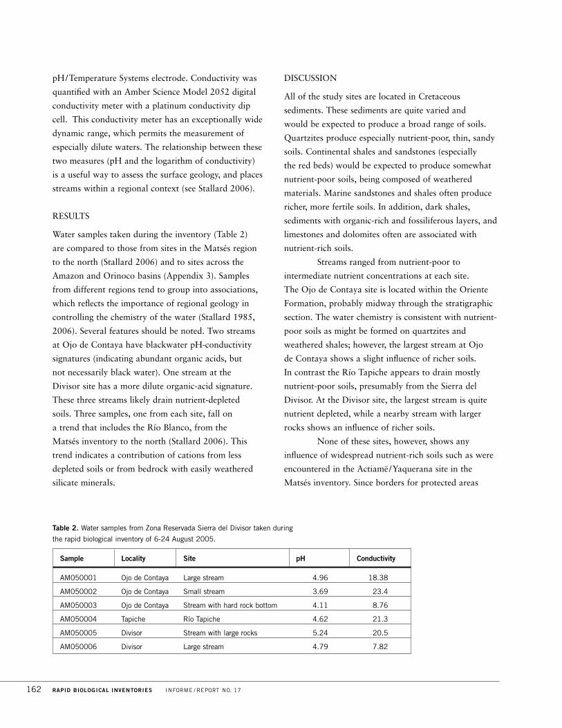
pH/Temperature Systems electrode. Conductivity was
quantified with an Amber Science Model 2052 digital
conductivity meter with a platinum conductivity dip
cell. This conductivity meter has an exceptionally wide
dynamic range, which permits the measurement of
especially dilute waters. The relationship between these
two measures (pH and the logarithm of conductivity)
is a useful way to assess the surface geology, and places
streams within a regional context (see Stallard 2006).
RESULTS
Water samples taken during the inventory (Table 2)
are compared to those from sites in the Matsés region
to the north (Stallard 2006) and to sites across the
Amazon and Orinoco basins (Appendix 3). Samples
from different regions tend to group into associations,
which reflects the importance of regional geology in
controlling the chemistry of the water (Stallard 1985,
2006). Several features should be noted. Two streams
at Ojo de Contaya have blackwater pH-conductivity
signatures (indicating abundant organic acids, but
not necessarily black water). One stream at the
Divisor site has a more dilute organic-acid signature.
These three streams likely drain nutrient-depleted
soils. Three samples, one from each site, fall on
a trend that includes the Río Blanco, from the
Matsés inventory to the north (Stallard 2006). This
trend indicates a contribution of cations from less
depleted soils or from bedrock with easily weathered
silicate minerals.
DISCUSSION
All of the study sites are located in Cretaceous
sediments. These sediments are quite varied and
would be expected to produce a broad range of soils.
Quartzites produce especially nutrient-poor, thin, sandy
soils. Continental shales and sandstones (especially
the red beds) would be expected to produce somewhat
nutrient-poor soils, being composed of weathered
materials. Marine sandstones and shales often produce
richer, more fertile soils. In addition, dark shales,
sediments with organic-rich and fossiliferous layers, and
limestones and dolomites often are associated with
nutrient-rich soils.
Streams ranged from nutrient-poor to
intermediate nutrient concentrations at each site.
The Ojo de Contaya site is located within the Oriente
Formation, probably midway through the stratigraphic
section. The water chemistry is consistent with nutrient-
poor soils as might be formed on quartzites and
weathered shales; however, the largest stream at Ojo
de Contaya shows a slight influence of richer soils.
In contrast the Río Tapiche appears to drain mostly
nutrient-poor soils, presumably from the Sierra del
Divisor. At the Divisor site, the largest stream is quite
nutrient depleted, while a nearby stream with larger
rocks shows an influence of richer soils.
None of these sites, however, shows any
influence of widespread nutrient-rich soils such as were
encountered in the Actiamë/Yaquerana site in the
Matsés inventory. Since borders for protected areas
162 RAPID BIOLOGICAL INVENTORIES INFORME / REPORT NO. 17
Sample Locality Site pH Conductivity
AM050001 Ojo de Contaya Large stream 4.96 18.38
AM050002 Ojo de Contaya Small stream 3.69 23.4
AM050003 Ojo de Contaya Stream with hard rock bottom 4.11 8.76
AM050004 Tapiche Río Tapiche 4.62 21.3
AM050005 Divisor Stream with large rocks 5.24 20.5
AM050006 Divisor Large stream 4.79 7.82
Table 2. Water samples from Zona Reservada Sierra del Divisor taken during
the rapid biological inventory of 6-24 August 2005.

proposals recently have been redrawn, this rich-soil
site now falls within the northern portion of Zona
Reservada. In addition, several other stratigraphic units
in the region should be weathering to nutrient-rich soils
and solute-rich stream waters. The total area of these
nutrient-rich sites may be small, but they should exist
based on the underlying geology.
RECOMMENDATIONS
The large geologic variability of the Cretaceous
rocks suggests that a wide variety of soils, stream
compositions, and therefore habitats should exist in the
Sierra del Divisor /Siná Jonibaon Manán Region. Based
on the limited number of stream samples collected, the
three study sites did not capture the full range of
possible environments. Future work should endeavor to
document such sites. The remnant volcanoes to the
south of this region should have excellent soils with a
broad spectrum of nutrients and might be an especially
interesting site for future study.
FLORA AND VEGETATION
Participants /Authors: Corine Vriesendorp, Nállarett Dávila,
Robin B. Foster, Italo Mesones, and Vera Lis Uliana
Conservation targets: Vegetation on the high hills (up to 650 m),
a singular ecological entity within the Amazon basin occurring
only in Peru and Brazil and unprotected within SINANPE; a
refuge for timber species (e.g., Cedrela fissilis and C. odorata,
Meliaceae; Cedrelinga cateniformis, Fabaceae) logged at
unsustainable levels in other parts of Loreto, Peru, and Amazonia;
stunted forests on poor soils occurring principally on hill crests; a
vast stretch of intact forest that forms a corridor between Parque
Nacional Cordillera Azul to the west, Parque Nacional da Serra do
Divisor in Brazil in the east, and the proposed Reserva Comunal
Matsés and the Comunidad Nativa Matsés in the north; a mosaic
of soils of poor to intermediate fertility that harbor several poor-
soil endemics; ten species potentially new to science
INTRODUCTION
Zona Reservada Sierra del Divisor is large (1,478,311
ha) and spans a wide range of habitat types. The
landscape varies broadly from rich floodplain clays in
the north to a central area of poor, sandy soils, and
includes an area in the south with richer soils that may
be volcanic in origin. To the north the area abuts the
Comunidad Nativa Matsés and to the east it borders
Brazil, forming an intact corridor with the Brazilian
national park, Parque Nacional da Serra do Divisor.
The western border loosely follows the Serranias de
Contamana. The southern limit is dominated by several
hill complexes and isolated cone-shaped peaks, and
forms part of Reserva Territorial Isconahua, an area set
aside for uncontacted indigenous people (Fig. 2A).
At least four expeditions have visited the
northern, western, and southern parts of the area,
although none had explored the central and eastern
areas. Three Peruvian conservation organizations—
ProNaturaleza, The Nature Conservancy–Peru, and the
Centro de Datos para la Conservación—jointly
organized biological inventories in 2000 (in the west,
along the Serranias de Contamana); in 2001 (in the
south, along the Río Abujao); in 2004 (in the west,
from the Serranias de Contamana to the edge of the
Ojo de Contaya); and in 2005 (in the southwest, along
the Río Callería)(FPCN/CDC 2001, 2005, unpub. data)
(Fig. 2A). Biological information for the northern part
of the Zona Reservada comes from a 2004 inventory
along the Río Yaquerana, directly south of the
Comunidad Nativa Matsés (see results for the
Actiamë site in Fine et al. 2006).
Our current inventory focused on the central
and eastern portions of the Zona Reservada and
included two large hill complexes: the Ojo de Contaya
and the southernmost of the two series of large ridges
that form the border, or divisor, with Brazil. Although
the western edge of the Ojo de Contaya was explored in
2004, our inventory was the first visit by biologists to
its center. Similarly, although there have been previous
inventories of scattered visits to the Brazilian side of the
Divisor ridge system, prior to our visit the biological
communities on the Peruvian side were entirely unknown.
PERÚ: SIERRA DEL DIVISOR DICIEMBRE / DECEMBER 2006 163

METHODS
During a rapid inventory the botanical team [5x50-m]
characterizes the vegetation types and habitat diversity
in an area, covering as much ground as possible.
We focus on the most common and dominant elements
of the flora while keeping an eye out for rare and/or
new species. Our catalogue of the plant diversity in the
area reflects collections of plant species in fruit or
flower, sterile collections of interesting and/or unknown
species, and unvouchered observations of widespread
species in Amazonia. We made several quantitative
measures of plant diversity, including a 5x50-m transect
at the first site (Ojo de Contaya), a 100-stem transect at
the third site (Divisor), and a survey of adult trees (see
Canopy Trees, below).
In the field, R. Foster took approximately
1,400 photographs of plants. These photographs are
being organized into a preliminary photographic guide
to the plants of the region, and will be freely available
at http: / / fm2.fieldmuseum.org/plantguides /.
All of the botanists contributed to the general
collections and observations. In addition, two members
of the group focused on particular plant families.
I. Mesones documented diversity in the Burseraceae
and V. Uliana surveyed a handful of herbaceous taxa,
including Costaceae, Heliconiaceae, Marantaceae, and
Zingiberaceae. At each site N. Dávila recorded the
abundance of the largest trees (individuals > 40 cm in
diameter at breast height) in different habitats, using a
combination of binoculars and fallen leaves to identify
individuals to species.
Plant specimens from the inventory are
housed in the Herbario Amazonense (AMAZ) of the
Universidad Nacional de la Amazonia Peruana in
Iquitos, Peru. Duplicate specimens have been sent
to the herbarium at the Universidad Nacional Mayor
de San Marcos (USM) in Lima, Peru, and triplicate
specimens to The Field Museum (F) in Chicago,
USA. Several duplicates of herbaceous specimens
have been donated to the Herbario da Universidade
de São Paulo (ESA).
FLORISTIC RICHNESS AND COMPOSITION
During our 18 days in the field, we recorded ca. 1,000
species at the three inventory sites (Appendix 2). Other
rapid inventories in lowland Amazonia have recorded
1,400-1,500 species in similar time frames using similar
methods (along the Río Yavarí, Pitman et al. 2003;
along the Apayacu, Ampiyacu, and Yaguas rivers,
Vriesendorp et al. 2004; between the Yaquerana and
Blanco rivers in the Matsés region, Fine et al. 2006).
However, these inventories spanned a wider range of
soil fertilities and included sites with much richer soils.
In the Zona Reservada, the inventory sites were
dominated by soils of poor to intermediate fertility, and
consequently plant communities were less diverse.
Richer soils are found within other parts of
the Zona Reservada, in the gentle hills in the north and
in the complex of scattered hills and ridges in the south.
We did not survey these areas, although we did fly over
them (see Regional Overview and Inventory Sites, above).
We estimate a regional flora of 3,000-3,500 species with
the inclusion of these areas. Without the richer-soil areas,
we estimate the sandier soils of the central and eastern
portions support ca. 2,000 plant species.
Because of the generally low soil fertilities,
many families had fewer species here than at most
Amazonian sites. Some families, however, are most
diverse on poorer soils, and we found Nyctaginaceae,
Lecythidaceae, Combretaceae, Clusiaceae, and
Euphorbiaceae to be surprisingly abundant and rich in
species at the three inventory sites. In addition
Rubiaceae, Fabaceae, Burseraceae, Meliaceae, and
Sapotaceae were among the most abundant and species-
rich families during the inventory, not unlike other
Amazonian sites. No herbaceous family was especially
diverse, although Marantaceae and Araceae were among
the most species rich, and certainly the most dominant.
Species richness of ferns and Myristicaceae was
markedly low, even for poor-soil communities.
At the generic level, Psychotria (16 species),
Sloanea (4), Ladenbergia (3), Guarea (12), Tachigali
(10), Ficus (15), Protium (11), Pourouma (8), Piper
(26), Inga (15), and Neea (11) were among the most
164 RAPID BIOLOGICAL INVENTORIES INFORME / REPORT NO. 17
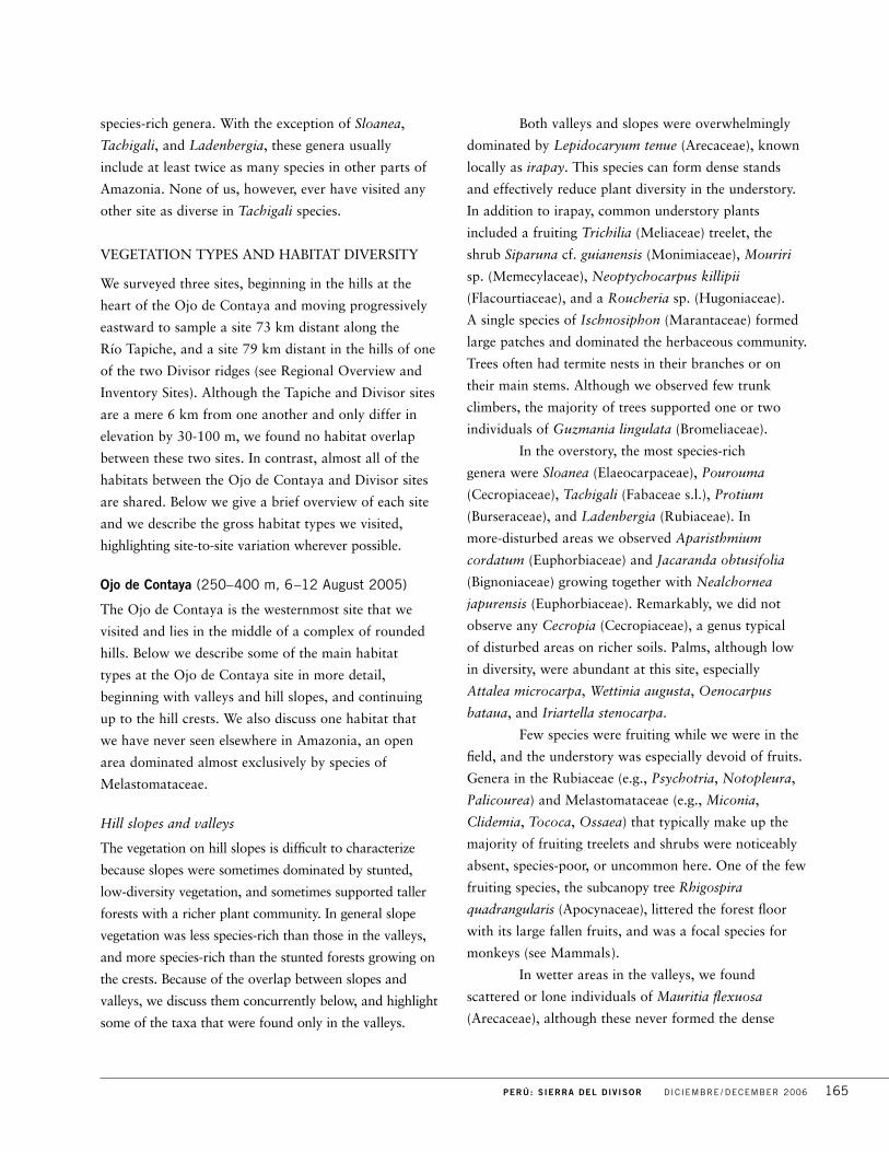
species-rich genera. With the exception of Sloanea,
Tachigali, and Ladenbergia, these genera usually
include at least twice as many species in other parts of
Amazonia. None of us, however, ever have visited any
other site as diverse in Tachigali species.
VEGETATION TYPES AND HABITAT DIVERSITY
We surveyed three sites, beginning in the hills at the
heart of the Ojo de Contaya and moving progressively
eastward to sample a site 73 km distant along the
Río Tapiche, and a site 79 km distant in the hills of one
of the two Divisor ridges (see Regional Overview and
Inventory Sites). Although the Tapiche and Divisor sites
are a mere 6 km from one another and only differ in
elevation by 30-100 m, we found no habitat overlap
between these two sites. In contrast, almost all of the
habitats between the Ojo de Contaya and Divisor sites
are shared. Below we give a brief overview of each site
and we describe the gross habitat types we visited,
highlighting site-to-site variation wherever possible.
Ojo de Contaya (250–400 m, 6–12 August 2005)
The Ojo de Contaya is the westernmost site that we
visited and lies in the middle of a complex of rounded
hills. Below we describe some of the main habitat
types at the Ojo de Contaya site in more detail,
beginning with valleys and hill slopes, and continuing
up to the hill crests. We also discuss one habitat that
we have never seen elsewhere in Amazonia, an open
area dominated almost exclusively by species of
Melastomataceae.
Hill slopes and valleys
The vegetation on hill slopes is difficult to characterize
because slopes were sometimes dominated by stunted,
low-diversity vegetation, and sometimes supported taller
forests with a richer plant community. In general slope
vegetation was less species-rich than those in the valleys,
and more species-rich than the stunted forests growing on
the crests. Because of the overlap between slopes and
valleys, we discuss them concurrently below, and highlight
some of the taxa that were found only in the valleys.
Both valleys and slopes were overwhelmingly
dominated by Lepidocaryum tenue (Arecaceae), known
locally as irapay. This species can form dense stands
and effectively reduce plant diversity in the understory.
In addition to irapay, common understory plants
included a fruiting Trichilia (Meliaceae) treelet, the
shrub Siparuna cf. guianensis (Monimiaceae), Mouriri
sp. (Memecylaceae), Neoptychocarpus killipii
(Flacourtiaceae), and a Roucheria sp. (Hugoniaceae).
A single species of Ischnosiphon (Marantaceae) formed
large patches and dominated the herbaceous community.
Trees often had termite nests in their branches or on
their main stems. Although we observed few trunk
climbers, the majority of trees supported one or two
individuals of Guzmania lingulata (Bromeliaceae).
In the overstory, the most species-rich
genera were Sloanea (Elaeocarpaceae), Pourouma
(Cecropiaceae), Tachigali (Fabaceae s.l.), Protium
(Burseraceae), and Ladenbergia (Rubiaceae). In
more-disturbed areas we observed Aparisthmium
cordatum (Euphorbiaceae) and Jacaranda obtusifolia
(Bignoniaceae) growing together with Nealchornea
japurensis (Euphorbiaceae). Remarkably, we did not
observe any Cecropia (Cecropiaceae), a genus typical
of disturbed areas on richer soils. Palms, although low
in diversity, were abundant at this site, especially
Attalea microcarpa, Wettinia augusta, Oenocarpus
bataua, and Iriartella stenocarpa.
Few species were fruiting while we were in the
field, and the understory was especially devoid of fruits.
Genera in the Rubiaceae (e.g., Psychotria, Notopleura,
Palicourea) and Melastomataceae (e.g., Miconia,
Clidemia, Tococa, Ossaea) that typically make up the
majority of fruiting treelets and shrubs were noticeably
absent, species-poor, or uncommon here. One of the few
fruiting species, the subcanopy tree Rhigospira
quadrangularis (Apocynaceae), littered the forest floor
with its large fallen fruits, and was a focal species for
monkeys (see Mammals).
In wetter areas in the valleys, we found
scattered or lone individuals of Mauritia flexuosa
(Arecaceae), although these never formed the dense
PERÚ: SIERRA DEL DIVISOR DICIEMBRE / DECEMBER 2006 165

aggregations known as aguajales common in other
parts of the Peruvian Amazon. Alongside the Mauritia
we typically found three species of Heliconia, including
H. hirsuta (Heliconiaceae), and a species of Costus
(Costaceae) that looks like C. scaber but has a yellow
flower and longer petioles. Along streams, we typically
observed scattered Melastomataceae, dense clumps of
herbaceous Marantaceae, Aparisthmium cordatum, an
Inga sp. (Fabaceae s.l.), a Solanum sp. (Solanaceae), an
occasional Mauritia flexuosa, and some Cyathea tree
ferns. The few germinating seedlings we observed were
growing principally in wetter areas. The majority of the
seedlings had large seeds, including species of Protium,
Tachigali, several Sapotaceae, and the palms Iriartella
stenocarpa and Euterpe precatoria.
In these forests we found two rare, monocarpic
species. Froesia diffusa (Quiianaceae) is rarely collected
and has medium sized, presumably bird-dispersed
fruits (see Pitman et al. 2003). Froesia was scattered
throughout the landscape, was relatively common in the
understory, and occurred at the Divisor inventory site as
well. We found three individuals of another monocarpic
rarity, Spathelia cf. terminalioides (Rutaceae), growing
alongside the sandstone stream.
Hill crests
The highest hill on the landscape crested at ca.
400 m. On the hill crests we observed two types of
forests, loosely correlated with the underlying soil types.
Stunted, low-diversity forests (with canopies 5-15 m
tall) grew on sandier soils, and taller, higher-diversity
forests (with canopies 25-35 m tall) grew on soils
with seemingly greater clay content. Generally, plants
in the stunted forests tended to be wind dispersed,
and plants in the taller forests on the hill crests, as well
as in the lower slopes and valleys, were principally
animal dispersed. We estimate that an overlap of only
5% exists between the plant communities in the stunted
forests and plant communities elsewhere in
the landscape.
In the stunted forest we found a community
of approximately 40 plant species, typically dominated
by a group of small trees including Macrolobium
microcalyx (Fabaceae s.l.), a potentially new species
of Pseudolmedia (Moraceae), Tovomita aff.
calophyllophylla (Clusiaceae), and Matayba sp.
(Sapindaceae). On some crests one of these dominants
would be missing, replaced by a Gnetum sp.
(Gnetaceae) or Ferdinandusa sp. (Rubiaceae).
Lauraceae was the most diverse family, with five
species, and there were three species of Cybianthus
(Myrsinaceae). Ferns dominated the understory and
often formed monodominant patches. The fern Schizaea
elegans, for example, formed a dense cover as we
approached one hill crest, and as we descended along
the other side of the hill it was replaced by another
fern, Metaxya rostrata.
In the tall, crest forest, Micrandra spruceana
(Euphorbiaceae) was abundant in all size classes. These
taller forests had an understory composition similar
to that of the plant communities growing on the hill
slopes and valleys, although because irapay did not
form dense stands and crowd out other species, the
understory community here was more diverse. Genera
more typical of richer soils, such as Inga, Guarea
(Meliaceae), and Protium, were more abundant in this
tall forest, and we observed several individuals of
Protium nodulosum, a clay specialist.
Melastomatal
At Ojo de Contaya we found open areas unlike any
we have seen in Amazonia, almost entirely dominated
by species in the Melastomataceae (Fig. 3C). In a survey
of six of these habitats, the diversity of Melatomataceae
ranged from 15-22 species and included Miconia spp.,
Graffenrieda sp., Salpinga sp., Maieta guianensis,
Ossaea boliviana, Tococa sp., and Miconia bubalina.
These melastomatales superficially resemble
the supay chacras, or “devil’s gardens,” that are abundant
throughout lowland Amazonia. Supay chacras are
open areas dominated by plants with ant mutualisms,
almost always including Cordia nodosa (Boraginaceae)
and Duroia hirsuta or D. saccifera (Rubiaceae). These
typical species were absent from the melastomatales,
166 RAPID BIOLOGICAL INVENTORIES INFORME / REPORT NO. 17

although we did find D. saccifera and C. nodosa
nearby in the forest understory, but without their usual
ant inhabitants. Moreover, although several of the
Melastomataceae (Tococa, Maieta) had ant associations,
we found two melastomatales without any ant plants.
These habitats remain a mystery; we do not understand
how they are formed, nor how they are maintained.
Tapiche (220–240 m, 12–18 August 2005)
This was our only site along a large river. A typical
floodplain flora grows along its banks, although this flora
is not as rich as those of floodplain forests elsewhere in
Peru (e.g., Madre de Dios) because the soils at this site
are nutrient poor. The river is a vulnerable entry point
into the area, and we observed evidence of timber
extraction at this site (Fig. 9A, see Timber Species below).
Although no habitat overlap exists between the
Ojo de Contaya and Tapiche sites, the sites share many
plant species. Except for the stunted forest communities
on the hill crests, the Ojo de Contaya flora is fully
represented here. The Tapiche site is continuous with
the slopes of the Divisor ridge (our third inventory site)
and these two sites are intimately connected, as the
streams that originate in the ridge system flow downhill
and feed the aguajal.
Floodplain forest
The Río Tapiche is a dominant force structuring
nearby plant communities. Although its influence is
most obvious along the riverbanks, the river shapes the
vegetation up to 40-50 m inland as well. Plant diversity
at Tapiche was higher than at the Ojo de Contaya and
Divisor sites, which almost entirely reflects the
contribution of the floodplain species.
Closest to the river, we observed typical
floodplain species, including Ficus insipida (Moraceae;
ojé), Acacia loretensis (Fabaceae s.l.), Cecropia
membranacea (Cecropiaceae), and Tachigali cf.
formicarum (Fabaceae s.l.). A community of species
associated with disturbances, all fast-growing and some
heavily defended (with spines, ants, or urticating
hairs) inhabits the river edge. This was a low-diversity
assemblage, and included abundant populations of
Urera laciniata (Urticaceae), Triplaris sp. (Polygonaceae),
Attalea butyracea (Arecaceae), Celtis schippii (Ulmaceae),
and Jacaranda copaia (Bignoniaceae). The diversity of
Euphorbiaceae, especially in small trees, was remarkably
high in these areas and included two species of
Alchornea, Acalypha diversifolia, and a Sapium sp.
Farther from the river there were a series of
terraces. On the lower terraces Geonoma macrostachya
and Chelyocarpus ulei (Arecaceae) dominated the
ground cover, with Tachigali, Wettinia augusta, and
Astrocaryum chambira (Arecaceae) common in the
overstory. Lianas in the Hippocrataceae were common
here, and rich in species. We found an important
domestic timber species, Hura crepitans (Euphorbiaceae),
growing in patches on the lower terraces.
Plant diversity increased with distance from
the river. On the higher terraces, the palms that were
abundant on the lower terraces disappeared, and species
of Marantaceae dominated along with juveniles of
Oenocarpus mapora (Arecaceae). The high terraces
supported a rich overstory that includes Hevea
guianensis (Euphorbiaceae), Protium nodulosum
(Burseraceae), Dipteryx (Fabaceae), and Simarouba
amara (Simaroubaceae). In the understory we registered
Siparuna cuspidata, Heliconia velutina (Heliconiaceae),
Geonoma camana (Arecaceae), Abarema sp. (Fabaceae
s.l.), Memora cladotricha (Bignoniaceae), and several
Pourouma spp. (Cecropiaceae). We saw some species
commonly found on the Manu floodplain, including
Carpotroche longifolia (Flacourtiaceae), Virola
calophylla (Myristicaceae), and large trees of Ficus
schultesii (Moraceae). We often found the lilac flowers
of Petrea (Verbenaceae) on the ground, highlighting the
abundance of this liana in these areas.
There were some differences between the
two sides of the river., For example, Heliconia chartacea
was seen only on one side and not the other. Notably,
no irapay (Lepidocaryum tenue) grows along the river
edges or on the terraces, although once one began
ascending the slopes towards the Divisor ridge this
species again dominated the understory.
PERÚ: SIERRA DEL DIVISOR DICIEMBRE / DECEMBER 2006 167

Mauritia palm swamp, or aguajal
The palm swamp at this site was expansive and
dominated the landscape. Our trail around its borders
was about 11 km long and we were able to survey
both within and outside the aguajal. In addition to
the characteristic Mauritia flexuosa, the palm swamp
supported a few other species, including Euterpe
precatoria, Cespedesia (Ochnaceae), Siparuna, a
Sterculia (Sterculiaceae) with enormously long leaves,
and several large trees, including a Buchenavia sp.
(Combretaceae) and several Ficus spp. (Moraceae).
On the better-drained soils along the border
of the aguajal, we documented a plant community
with higher diversity. Here we commonly observed a
Trichilia sp. (Meliaceae), Naucleopsis ulei (Moraceae),
Minquartia guianensis (Olacaceae), at least three species
of Guarea (Meliaceae), a big-leaved Pouteria sp.
(Sapotaceae), and a Parinari sp. (Chrysobalanaceae). One
of the more locally dominant species around the aguajal
is Cassia cf. spruceanum (Fabaceae s.l.), which has white
undersides on its leaflets. Additionally we observed two
species of Virola (Myristicaceae), an Inga sp. (with four
leaflets, yellow hairs, and a large rachis wing), a Casearia
sp. (Flacourtiaceae), and a Talisia sp. (Sapindaceae).
Miconia tomentosa (Melastomataceae), common at the
Ojo de Contaya, was dominant here as well.
Along the streams that flow into the aguajal
we observed two species of Psychotria (Rubiaceae),
P. caerulea and P. cf. deflexa, as well as Piper augustum
(Piperaceae), a Besleria sp. (Gesneriaceae) with orange
axillary flowers, and a shrubby Alchornea sp.
(Euphorbiaceae). The wet areas along the edge of the
aguajal were covered in seedlings, including Dicranostyles
(Convolvulaceae), Protium, Pourouma, several species
of Menispermaceae, Aparisthmium cordatum, Hymenea
(Fabaceae s.l.), and Socratea exorrhiza, Oenocarpus
mapora and Iriartea deltoidea (Arecaceae).
Divisor (250–600 m, 18–24 August, 2005)
The Ojo de Contaya and Divisor sites are separated by
only 80 km and they are notably similar in floristic
composition and habitat diversity. This is especially
remarkable given that these two habitats are separated
by a continuous stretch of markedly dissimilar habitat:
a lowland forest with gentle topography, and no raised
hill formations like the ones in Ojo de Contaya and
Divisor. The underlying rocks in the two areas appear to
be the same, and there is similar small-scale variation in
quartzite and sandstone substrates.
However there are several obvious differences
between the two sites. Because of the higher hills in the
Divisor ridge (up to ca. 800 m), and the prevailing
winds from the Brazilian side, the Divisor ridges are
much wetter and more humid than are those of the
Ojo de Contaya. Moreover, the hills in this area are
not rounded as are ridges of the Ojo de Contaya;
the crests of the Divisor are longer and flatter. Also,
at Divisor the tallest hill crests do not support stunted
forests. Instead, the stunted forest appears to grow only
on the tops of smaller hills.
We are unsure of the factors that shape and
maintain the stunted forests. Our working hypothesis
is that infrequent lightning strikes, perhaps every 500
years, burn the driest areas. Some support exists for this
hypothesis because the well-drained hilltops with
stunted forests, underlain by a porous sandstone layer,
appear to be the driest areas in the landscape.
Moreover, we found evidence of lightning strikes and
burns on hill crests in both Divisor and Ojo de Contaya.
Below we describe the flora and habitat types of
Divisor in more detail. In these descriptions we include a
brief mention of the habitat between the Tapiche and
Divisor inventory sites, as we explored a 10-km stretch
during our walk from one camp to the other.
Hill slopes and valleys
(including slope from Tapiche to Divisor)
The slopes in this region are more steeply inclined
than the rounded hills at Ojo de Contaya. At both sites
the soils vary over similar, small spatial scales. Sediments
are principally sandy, but in some areas soils can be a
mixture of sand, red clays, and/or gray clays because of
old landslides and lateral slumps. Some species may
be responding to these localized soil conditions.
168 RAPID BIOLOGICAL INVENTORIES INFORME / REPORT NO. 17

Our survey, however, focused mainly on the most
common elements of the flora, as described below.
The understory often was dominated by irapay
(Lepidocaryum tenue), although we found one area
covered in Ampelozizyphus cf. amazonicus
(Rhamnaceae). One of the most common species was
Tachigali vasquezii (Fabaceae), and often upwards of
ten individuals could be counted from a single vantage
point. Tachigali species richness was higher at Divisor
than any other site we have ever visited, principally on
slopes and valleys. Other common species in the
understory and subcanopy included Capparis sola
(Capparidaceae), Aparisthmium cordatum, and several
species of Neea (Nyctaginaceae).
Several genera of Rubiaceae were common
here, including Bathysa, Ferdinandusa, and Rustia.
In the understory, Dieffenbachia (Araceae) was among
the common herbs, and Didymocleana trunculata was
the most common fern. Several species formed near
monodominant stands in the understory, including the
explosively dehiscent Raputia hirsuta (Rutaceae) and the
treelet Nealchornea japurensis.
A lower diversity assemblage grew along
streams. It included abundant Chrysochlamys ulei
(Clusiaceae) along with Aparisthmium cordatum,
Froesia diffusa, juvenile Micrandra spruceana,
Pholidostachys synanthera (Arecaceae), Marila sp.
(Clusiaceae), Tovomita weddelliana (Clusiaceae), and
one of the largest Heliconia in the world, H. vellerigera.
Along one of the slopes we found Podocarpus cf.
oleifolius (Podocarpaceae, Fig. 4B). (Podocarpus is a
rare and “primitive” genus more commonly associated
with montane sites.)
Diversity in slopes and valleys was moderate
compared to other sites in lowland Amazonia. In a 100-
stem transect of individuals 1-10 cm diameter at breast
height (dbh) we recorded 65 species, compared to 88
species in areas close to the Colombian border south of
the Putumayo river (Vriesendorp et al. 2004) and 80
species in areas north of the Zona Reservada along the
Río Yavarí (Pitman et al. 2003). In Divisor, the most
common species was represented by a Rustia sp. with
5 individuals, followed by Tachigali sp. (4), Guarea sp.
(4), and Iryanthera sp. (4; Myristicaceae).
In the flatter, lower elevation areas in Divisor
we observed substantial populations of timber species,
including more than 20 individuals of Cedrela fissilis
(Meliaceae) and several Cedrelinga cateniformis
(Fabaceae; see Timber Species, below).
Hill crests
As in Ojo de Contaya, both tall forests and stunted
forests grew on hill crests, with almost no species
overlap between the two forest types. The stunted forests
were more extensive in Divisor, but this may reflect the
longer, bigger hill crests here compared to the smaller,
rounder crests in Ojo de Contaya. Stunted forests were
yet more stunted in Divisor as well, with 2-m tall
canopies in some areas. About 80% of the stunted
forest flora appears to be shared between the two sites,
although the species unique to Divisor are some of the
most exciting records of the inventory.
At least two of these species appear to be new
to science, and include a dwarf Parkia also recorded at
1,500 m during the Cordillera Azul inventory (Foster et
al. 2001) as well as an Aparisthmium with small leathery
leaves (Fig. 4C). Other species only recorded at Divisor
include a Pagamea sp. (Rubiaceae) and a Bonnetia sp.
(Theaceae, Fig. 4I). One species known to be resistant to
fire, Roupala montana (Proteaceae), was observed only
here, and lends support to the notion that these are plant
communities shaped by infrequent fires.
In contrast to the unique flora observed in the
stunted forests, the taller forest shared species with valley
and slope habitats, both here and in the Ojo de Contaya.
Some of the more common species in the understory
included Neoptychocarpus killipii, Oenocarpus bataua
(Arecaceae), a Caryocar sp. (Caryocaraceae), several
species of tree ferns, and Tachigali spp., as well as
Couepia and Licania (Chrysobalanaceae). As in the tall
forest in Ojo de Contaya, Micrandra spruceana
dominated the overstory. One of the more exciting finds in
the tall forests was a Moronobea tree (Clusiaceae) that is
potentially new to science.
PERÚ: SIERRA DEL DIVISOR DICIEMBRE / DECEMBER 2006 169

CANOPY TREES (Nállarett Dávila)
Although canopy trees represent only 30% of the flora
in tropical forests (Phillips et al. 2003), they are an
essential part of the forest structure and provide
habitats for numerous other organisms. We sampled
large overstory trees at all three inventory sites in our
inventory of Zona Reservada Sierra del Divisor.
Depending on the breadth of the habitat, we
established either 20x500-m or 10x1000-m transects
and measured trees at least 40 cm in diameter at breast
height (dbh). We established as many transects as
possible at each site. We recorded 150 species of canopy
trees. Fabaceae was the most species-rich family, as is
true of most tropical forests (Gentry and Ortiz 1993;
Terborgh and Andresen 1998). Below we summarize
our results for each site and then briefly discuss the
overlap in species composition among sites.
In the Ojo de Contaya we distinguished
two main habitat types: hill crests, and hill slopes
and valleys. Hill crests principally supported stunted
vegetation with stems <40 cm dbh, and therefore we
did not conduct any tree surveys. In the taller forest
(canopy ca. 30 m tall) growing on the hill slopes
and valleys, we registered approximately 90 species.
Cariniana decandra (Lecythidaceae), Licania micrantha
(Chrysobalanaceae), and Qualea sp. (Vochysiaceae)
were the most common species, and all are typical of
poor soils (Spichiger et al. 1996). The tall canopies
tended to be closed, with few light gaps.
Floristic composition in the overstory changed
radically in Tapiche, reflecting the river floodplain and
the large palm swamp. Fewer species were recorded
here; we registered only about 70 species, dominated by
members of the Fabaceae, Euphorbiacae, and Moraceae.
The most common species were Alchornea triplinervia
(Euphorbiaceae), Acacia loretensis (Fabaceae s.l.) and
Ficus sp. (Moraceae). Structurally the canopy was
more open in the Tapiche site, favoring rapid tree
growth, and we observed several majestic emergents
along the river banks, including Ficus spp. (Moraceae)
and Hura crepitans (Euphorbiaceae). In the aguajal we
saw few canopy species because of the dominance of
Mauritia flexuosa. Around its borders, however, we
observed Huberodendron swietenioides (Bombacaceae),
Cedrelinga cateniformis, Parkia cf. multijuga (Fabaceae),
Brosimum rubescens (Moraceae) and several species
of Lauraceae.
Divisor was similar floristically to the
Ojo de Contaya, with sandy and sandy-loam hills.
Here we registered ca. 85 canopy tree species. Fabaceae
and Euphorbiaceae were the most important families.
Some areas, especially lower-lying ones, were dominated
by Huberodendron swietenioides (Bombacaceae, Fig. 4E).
Growing alongside H. swietenioides we commonly
encountered Tachigali sp. (Fabaceae), Ocotea cf.
javitensis (Lauraceae), and Micrandra spruceana
(Euphorbiaceae), a characteristic species with large
tabular buttresses. On higher slopes, M. spruceana
became even more dominant and grew alongside
Brosimun rubescens (Moraceae), Macrolobium
acaciifolium (Fabaceae s.l.), and Jacaranda copaia
(Bignoniaceae). Similar to the Ojo de Contaya, at this
site there were hill crests covered with stunted
vegetation that we could not survey for big trees.
We observed more trees flowering and fruiting
at Tapiche and Ojo de Contaya than at Divisor. One
notable fruiting species at Divisor was Cedrela fissilis,
an important timber species (see Timber Species, below).
A comparison of the three inventory sites reveals that
Ojo de Contaya and Divisor are the most similar,
sharing 60% of tree species, while Tapiche shares only
20% of its tree species with the two other sites.
BURSERACEAE (Italo Mesones)
Members of the Burseraceae were well represented in
this inventory. We observed 29 species in four genera,
with the bulk of the richness in the genus Protium (with
24 spp.). This represents an intermediate richness for
Protium, and almost certainly reflects the relatively poor
soils of the inventory sites. In comparison, Fine (2004)
and Fine et al. (2005) registered 36 species of Protium
in Allpahuayo-Mishana (near the city of Iquitos) across
a greater fertility gradient, from rich soils of the Pevas
Formation to poorer white-sand soils. Below we detail
170 RAPID BIOLOGICAL INVENTORIES INFORME / REPORT NO. 17

several of the more interesting records of Burseraceae
in the Zona Reservada.
Although the area is dominated by poor soils,
we found several clay specialists. In the Ojo de Contaya,
we found areas where Protium hebetatum dominated
the subcanopy, especially in the valley bottoms. This
species prefers richer soils, but probably responds to the
nutrients deposited in the valley bottoms, eroded
downslope by rains. Similarly, areas at Tapiche and
Divisor were dominated by Protium nodulosum in every
size class, with some individuals reaching 30 cm dbh and
standing 20 m tall. This species typically is found
growing in soils with moderate to high fertility levels and
substantial clay content. In the Zona Reservada, both P.
hebetatum and P. nodulosum appear to be tolerating
sandier conditions than they do normally.
A poor-soil specialist, Protium heptaphyllum,
dominated several of the crest forests growing on sandy,
well-drained soils. This species has been found growing
in stunted habitats in other white-sand areas of Peru
(Allpahuayo-Mishana, Jeberos, Río Morona,
Tamshiyacu, Jenaro Herrera, and Río Blanco). Typically
these habitats have high levels of endemism, with
upwards of 50% of the species restricted to these poor-
soil areas. Three other poor-soil specialists were found
during the inventory: P. calanense, P. paniculatum, and
P. subserratum.
Sites varied little in their levels of Burseraceae
diversity, but a different suite of species was dominant
at each site. For example, each of the inventory sites
had one species of Dacryodes and one species of
Trattinnickia. However, each site supported their own
unique species within these genera, with no species
overlap among sites. Similarly, different species of
Protium dominated at each site, although several species
occurred at more than one site, or at all three sites.
We found 15 species of Burseraceae at Ojo
de Contaya, including 13 species of Protium. Protium
hebetatum and P. heptaphyllum subsp. ulei were the
most abundant. At Tapiche, we registered 14 species
of Burseraceae, including 11 species of Protium,
and 1 Crepidospermum. Here Protium nodulosum,
P. trifoliatum, and P. amazonicum, all specialists
of moderate to richer soils, were most abundant.
At Divisor, we registered the greatest diversity of
Burseraceae (17 species), including 15 species of
Protium. The most abundant species were Protium
nodulosum, P. heptaphyllum, and P. paniculatum.
These species cover a range of soil preferences from
the poorest soils (heptaphyllum), to much richer
ones (nodulosum), and some soils of intermediate
richness (paniculatum).
HERBACEOUS TAXA (Vera Lis Uliana)
Overall, herbaceous diversity in the Zona Reservada
was low. Plants in the order Zingiberales dominated
the herbaceous taxa and were concentrated in humid
environments close to waterways. Within the Zingiberales,
the most species-rich family was Marantaceae (with 26
species), followed by Heliconiaceae (7), Costaceae (3),
and Zingiberaceae (1). Below we describe the taxa that
dominated the herb community at each inventory site, and
discuss several rare and interesting herbaceous plants.
There was substantial overlap in Marantaceae
among sites. The understory in Ojo de Contaya and
areas outside of the palm swamp at Tapiche were
dominated by the same Ischnosiphon sp. (Marantaceae).
Within the palm swamp at Tapiche we observed two
species of Ischnosiphon. The most abundant species was
I. arouma and the other species remains unidentified.
At Divisor we also observed I. arouma near streams, as
well as two species of climbing Ischnosiphon, one an
unidentified species and the other I. killipii. In drier
areas at Ojo de Contaya and Divisor we found Calathea
micans and Monotagma sp. closer to the hill crests.
Only two species occurred at all three sites,
C. micans and C. aff. panamensis.
In the Helicioniaceae, Heliconia stricta was
rare, while H. velutina and H. lasiorachis were more
common and found close to flooded sites. We found
H. vellegeria, which is the largest Heliconia in the world
(standing up to 4 m tall), only in Divisor.
All of the species in the Zingiberales can be
cultivated as ornamentals, with Calathea and Heliconia
PERÚ: SIERRA DEL DIVISOR DICIEMBRE / DECEMBER 2006 171

the most commonly cultivated species. People living
along rivers in Amazonia typically use the petiole and
leaves of I. arouma for making baskets (Ribeiro et al.
1999), especially as this species grows along Mauritia
palm swamps, which often are focal sites for hunting
and gathering.
TIMBER SPECIES (Italo Mesones)
Although the Sierra del Divisor is a remote area, it
suffers the same extractive pressures that threaten
timber species throughout the Amazon. For more than
60 years, timber resources in the Peruvian Amazon have
not been managed and are exploited in the Peruvian
Amazon at an alarming and unmanaged rate. Networks
of streams and rivers facilitate access to these timber
populations. Because of intense extraction in the past,
few timber species currently can be observed along
waterways. This is especially true for species that are
most important in domestic and international markets,
such as caoba (Swietenia macrophylla, Meliaceae),
cedro (Cedrela odorata and C. fissilis, Meliaceae), and
tornillo (Cedrelinga cateniformis, Fabaceae).
As nearby timber sources are exhausted,
loggers look for timber in more remote places, placing
the long-term survival of timber species in danger.
Moreover, people are switching to lesser timber species,
such as cumala (Virola spp. and Iryanthera spp.,
Myristicaceae), catahua (Hura crepitans, Euphorbiaceae),
lupuna (Ceiba spp., Bombacaceae), moena (Ocotea spp.,
Nectandra spp. and Licaria spp., Lauraceae), and
pashaco (Parkia spp., Fabaceae). The switch to lesser-
known timber species is occurring especially in those
areas where little timber remains.
In this bleak context, our observations
during the inventory were somewhat reassuring. We
encountered reproductive populations of cedro, tornillo,
cachimbo caspi (Cariniana, Lecythidaceae), moena, and
others, especially in the Divisor headwaters. These areas
currently are serving as refuges, where seeds can be
produced and dispersed to other areas. Cedro and
tornillo were the most abundant species, and are wind-
and water-dispersed.
However, other observations during the
inventory were more troubling. In the Tapiche area we
found stumps of cedro, tornillo, and the medicinal plant
sangre de grado (Croton lechlerii, Euphorbiaceae).
These stumps appear to date to as long as 20 years ago.
We saw no reproductive trees in Tapiche, only juveniles
that may reflect pre-felling reproduction, or seeding into
these areas from refuge populations.
Our observations underscore the importance
of conserving the headwaters that originate in the Sierra
del Divisor ridge complex. This protection would allow
populations in heavily affected areas to recuperate, and
would be an important step towards the long-term
persistence of these timber species.
NEW SPECIES, RARITIES, AND
RANGE EXTENSIONS
During the inventory we collected more than 500 fertile
specimens. Currently we suspect that about ten species
may be new to science. Below we briefly describe some
of these, as well as several species that are rare or that
represent substantial range extensions.
On the hill crests with stunted vegetation we
found at least two species potentially new to science.
The first is a fruiting specimen found only in the stunted
forests at Divisor, a “bonsai” Parkia (Fabaceae s.l.,
Nállarett Dávila collection number ND1696), which
also was seen but not collected at 1,500 m in the
Cordillera Azul (Foster et al. 2001). Since our record in
Sierra del Divisor is from only ca. 400 m, the two
localities currently known for this species span an
elevational gradient of more than 1,000 m. Also, only
one widespread species of Aparisthmium (Euphorbiaceae)
is known in the Neotropics, A. cordatum. However, we
found individuals on the ridge crests in Divisor that
appear to be a new species in this genus (ND1882,
ND1884), with much smaller and more leathery leaves
(Fig. 4C).
Two large trees in the Clusiaceae also appear
to be new species. One, a Moronobea (ND1924), has
a much smaller white flower than the other species
known from this genus and was found growing in the
172 RAPID BIOLOGICAL INVENTORIES INFORME / REPORT NO. 17

taller crest forest in Divisor. Another, a Calophyllum
(ND1569) found in the valleys at Ojo de Contaya,
has smaller leaves compared to the well-known timber
tree, C. brasiliense, and has green (not white) sap in its
trunk and leaves (Fig. 4J).
Two species of Calathea, both found in
Ojo de Contaya and Tapiche, probably are new to
science. One has leaves that vary from green to a
variegated dark- and light-green leaf, with a green
inflorescence and white flowers (Vera Lis Uliana
collection number VU1396, Fig. 4H). The other species
has leaves with a metallic sheen to its undersides and
is known from Acre in Brazil, but remains undescribed
(VU1397).
At Ojo de Contaya we recorded three
individuals of a rare monocarpic species, Spathelia
terminalioides (Rutaceae, ND1984), growing alongside
a stream, in an open area. This species is known from
Cusco and Loreto in Peru, and was recorded during an
inventory in Federico Roman, in Pando, Bolivia
(Alverson et al. 2003). Another rare species was
recorded in Divisor when we found an individual of
Podocarpus cf. oleifolius (Fig. 4B, ND1985). Typically
this genus is restricted to montane areas; this species
does occur in the lowlands in other parts of Peru,
however, but almost exclusively on white sands.
In Divisor, we found Ficus acreana
(Moraceae, Fig. 4G) a species previously known
only from Brazil and Ecuador. A species that we
initially suspected to be new, a bipinnate legume, is
Stryphnodendron polystachyum (Fabaceae). After
reviewing our collections from previous inventories, it
appears that this species is poorly known but widespread.
THREATS, OPPORTUNITIES, AND
RECOMMENDATIONS
Currently, the greatest threats to the flora of Zona
Reservada Sierra del Divisor are illegal timber
extraction, oil exploration, and mining. During our
four-day stay along the Río Tapiche, we observed
several boats going upriver to scout timber (Fig. 9A).
In addition, communities surveyed by the social
inventory team report that there are illegal loggers
entering the protected area along most, if not all, of
the principal waterways. Oil exploration and mining
operations overlay the volcanic areas in the south.
Overflights and geological maps of the area indicate that
this area is one of the highest conservation priorities.
The Zona Reservada, with its high hills rising
up from the Amazon basin, is unlike any other place in
the world. In only three weeks in the field we found ca.
ten plant species potentially new to science and explored
habitats that we had never seen previously in Amazonia
(e.g., melastomatales and acidic ridge tops with stunted
forest). The headwater areas along the Brazilian border
serve as a refuge for timber species overexploited in
other parts of South America. Because of its biological
singularity and its importance as a source area for
timber species, we recommend immediate protection
of the Zona Reservada.
Our inventory is the fifth in the Sierra del
Divisor /Siná Jonibaon Manán Region, yet there is one
obvious area that remains unexplored. If possible, and
with the permission of local and national indigenous
federations, we recommend that biologists visit the
southern area that includes the volcanic cones.
FISHES
Participants /Authors : Max H. Hidalgo and José F. Pezzi Da Silva
Conservation targets: A unique fish community inhabiting aquatic
environments in Ojo de Contaya; the upper Río Tapiche, which
forms essential headwater areas for migration and reproduction of
important commercial and subsistence species; Hemigrammus,Hemibrycon, Knodus, and Trichomycterus species (present in
remote streams in Ojo de Contaya and in the hills of Divisor) that
represent new records for Peru or possibly species new to science;
species of Cheirodontinae present in the Río Tapiche and
principal tributaries, including Ancistrus, Cetopsorhamdia,Crossoloricaria, and Nannoptopoma that are also new to science;
ornamental species of Cichlidae, Gasteropelecidae, Loricariidae,
Anostomidae, and Characidae in the Tapiche; important
commercial and subsistence species that are significant sources
of protein for native human communities inhabiting the area,
such as Pseudoplatystoma tigrinum, Brycon spp., Salminus,Prochilodus nigricans, and Leporinus
PERÚ: SIERRA DEL DIVISOR DICIEMBRE / DECEMBER 2006 173

INTRODUCTION
Zona Reservada Sierra del Divisor is located in eastern
Peru between the east bank of the Río Ucayali and the
Brazilian border, in the departments of Loreto and
Ucayali. There are several drainage basins located in this
area. The principal north-south basins include those of
the Yaquerana, Tapiche, Buncuya, Callería, and Abujao
rivers. When these and others rivers whose headwaters
form in the Sierra del Divisor are taken into account,
there are eleven river basins. Most drain towards the
right (east) margin of the Río Ucayali. The Río
Yaquerana, located in the extreme northeast corner of
the Zona Reservada, is an exception; it drains into the
Amazon, almost 400 km downriver from Sierra del
Divisor, at Peru’s easternmost point in Loreto.
Although the ichthyofauna of this vast region
is now under study, significant gaps in our knowledge
remain, especially for many of the tributaries of the
Ucayali (Ortega and Vari 1986), including the majority
of those in the Zona Reservada. Fowler (1945) completed
one of the first compilations of the fish diversity of Peru,
which listed approximately 500 continental species and
noted which species are present in the Ucayali basin.
Later, Ortega and Vari (1986) published the first
annotated list of Peru’s freshwater fish, bringing the
total to 736 species. One conservative estimate of Peru’s
continental ichthyofauna diversity suggests that there
could be more than 1,100 species (Ortega and Chang
1998), which places Peru among the ten most species-rich
countries in the world with respect to ichthyofauna
(Thomsen 1999).
Based on these estimates, the ichthyofauna of
the Río Ucayali basin easily could surpass 600 species.
This estimate is supported by studies conducted in some
tributaries in areas adjacent to the Andes, such as the
Pisqui and Pachitea basins (de Rham et al. 2001; Ortega
et al. 2003), in areas around Pucallpa (Ortega et al.
1977), and the fish collection of the Museo de Historia
Natural de la Universidad Nacional Mayor de San
Marcos, Lima. Andean tributaries, such as the Pachitea,
harbor more than 200 fish species (Ortega et al. 2003),
and 171 species have been recorded at Pucallpa.
Within the Zona Reservada, some
ichthyological inventories have been conducted in the
most accessible regions of the Ucayali. In 2000, an
expedition visited Aguas Calientes in Cerros de
Contamana (FPCN/CDC 2001); in 2001, the Río
Shesha (a tributary of Río Abujao) was studied
(FPCN/CDC 2001); and most recently, the western
side of Ojo de Contaya at the headwaters of Quebrada
Maquía was explored (FPCN/CDC 2005). These studies
report low to moderate fish diversity. The ichthyofauna
from the following aquatic environments remains
unknown: the sub-basins of the Buncuya, Zúngaro,
Callería, and Utuquinía rivers, and the upper Abujao.
During this inventory in the Zona Reservada,
we evaluated aquatic environments in three previously
unexplored areas in the central portion of Ojo de
Contaya and the headwaters of the Río Tapiche. Our
primary objective was to determine the presence of
fish species, populations, or communities that could
be considered conservation targets to support the
establishment of a protected area in Sierra del Divisor.
In the three sites (Ojo de Contaya, Tapiche, and
Divisor) we explored diverse aquatic environments, such
as rivers, streams, aguajales (palm swamps), tahuampas
(temporary pools in the forest interior), and lagoons.
Our results reveal an interesting ichthyofauna of
scientific, sociocultural, and economic value.
METHODS
During 15 days of fieldwork, we studied the greatest
number and variety of aquatic habitats that we were
able to access from our camps. A local guide
accompanied us during each fishing excursion and we
walked to each site. We sampled 28 stations, 5 to 13 per
camp, and we noted the geographic coordinates of each
sampling station and recorded basic characteristics of
the aquatic environment being sampled. This
information is summarized in Appendix 4.
Of the 28 sampled sites, 23 were lotic
environments, either rivers or streams, and 5 were
lentic, including two aguajales (at Ojo de Contaya and
Tapiche), two lagoons (both at Tapiche), and one
174 RAPID BIOLOGICAL INVENTORIES INFORME / REPORT NO. 17

temporary flooded pool, or tahuampa (Ojo de
Contaya). The lentic environments (aguajal and ponds)
were largest at Tapiche, and the tahuampa found in Ojo
de Contaya was small. Most habitats in the inventory
were clearwater lotic environments; the aguajales, one
pool and the tahuampa were blackwater. The oxbow
lake at Tapiche was the only whitewater habitat.
We conducted mostly diurnal collections
(between 08:00 and 15:00 hours), although we made
one nocturnal collection in the Río Tapiche to try to
trap species active at night. Water levels of the principal
tributaries were low because it was the dry, or less rainy,
season. This helped us sample all of the identified
habitats and microhabitats more effectively. For example,
the average depth of the Río Tapiche was 50 cm,
allowing us to walk up to 1 km in the main channel to
collect from this microhabitat. Back at the camps during
the afternoons, we identified collected material.
We collected fish using 10x2.6-m and 5x1.2-m
fine-meshed nets (of 5 and 2 mm, respectively). We used
these repeatedly to sweep towards the bank or as traps
after disturbing areas serving as refuges, such as places
with fallen branches and leaves, rapids with rocky
bottoms, and areas along the banks with roots. In major
streams, lagoons, and the Río Tapiche, we used a 1.8 m
cast-net with 12 mm mesh openings. In the aguajales
and shallow, small streams we used a hand net (calcal)
with a diameter of 40 cm, with a 75 cm bag and
netting of 2 mm.
We also used hooks and lines in the
Río Tapiche to catch larger fish, such as tigre zúngaro
(Fig. 5D), piraña, and sábalos, which were identified
and photographed. None of these were preserved as
speci-mens. In some clearwater environments, we were
able to make direct observations to determine the
presence of a few, easily identifiable species without
having to collect them. We also used a small sound
amplifier to detect the electric fields of gymnotiform fish
in environments such as aguajales or in streams with
submerged vegetation where they seek refuge during the
day because their habits are mostly nocturnal. We had
success in some of our attempts to collect individual
gymnotiformes after determining their presence in
this way.
Collected samples were preserved immediately
in a 10% formol solution for 24 hours. In each camp,
we identified the species and then transferred them to
cotton gauze soaked in 70% ethyl alcohol for transport
to the Museo de Historia Natural, Lima, where they
were added to the scientific collection of the Department
of Ichthyology. In the field, we were unable to identify
various groups to species level and provisionally sorted
them to morphospecies. Further identifications for these
morphospecies require additional laboratory study. This
methodology has been applied in other rapid inventories,
such as Yavarí and Ampiyacu (Ortega et al. 2003;
Hidalgo and Olivera 2004).
RESULTS
Description of the aquatic habitats at each camp
Ojo de Contaya
From satellite images we determined that the streams in
this site drain northeast towards the headwaters of the
Río Buncuya, which eventually flow into the east bank
of the Río Ucayali, downriver of Contamana. Aquatic
habitats at this campsite correspond almost entirely to
first, second, and third order streams and are covered by
closed forest canopy, thereby having very little primary
productivity. Other aquatic habitats present included
one aguajal and a temporary flooded pool. Both were
small blackwater habitats (less than 10 m in length)
with muddy bottoms covered by organic material and
fallen leaves.
We identified only one stream wider than 5 m.
The other streams are characterized by clear water, an
average width of 4 m wide, an average depth of 30 cm,
and a maximum depth of 70 cm (only in the largest
stream). Their velocities were slow to moderate, they
had narrow banks, and almost all streams had sandy
bottoms. Only one stream had a rocky bottom in a 200-m
long section, with areas of rapids that reached 3 m in
height. There was a large amount of allochthonous
plant material, such as logs, branches, and leaves. This
material provides both refuge and food for electric fish,
PERÚ: SIERRA DEL DIVISOR DICIEMBRE / DECEMBER 2006 175

small catfish, smaller characids, and many aquatic
invertebrates.
This region is in a hilly area without any
significant flooded areas, except for one tahuampa.
These drainage systems are far from lowland areas
where larger rivers such as the Buncuya and Tapiche
are located. We sampled 13 stations at this camp.
Tapiche
This site is part of the headwaters of the Río Tapiche,
which flow into the right bank of the Río Ucayali at the
latitude of Requena. From this camp, we surveyed the
Río Tapiche, two large streams on the right bank of the
Tapiche, a large aguajal, one forest pool, and an oxbow
lake still in contact with the river.
The most representative habitat in this site is
the Río Tapiche, which is a medium-sized river with
clear, transparent waters. It is approximately 35 m wide
and shallow (50 cm average depth). Its sandy bottom
has some piled, fallen, and submerged trunks and the
banks vary from narrow, in straight sections, to broad
at some bends where sandy beaches are found. The
river-edge vegetation varies. Along some parts of the
river’s course, it barely covers the banks, while in others
it stretches out over the river 3 m from the water’s edge,
creating microhabitats suitable for some fish species,
such as carachamas and some Characiformes. The
course of the Río Tapiche is meandering and forms
oxbows that we also evaluated during this inventory.
The streams had clear, completely transparent
water with almost no color, or just slightly green. Average
stream width was 8 m. As at Tapiche, the streams had
sandy bottoms and narrow banks with riparian vegetation
covering part of the watercourse. The presence of fallen
logs and leaves was more prevalent in these habitats, and
only one stream close to the camp had sections of
“rapids” close to hilly areas. These rapids had rocky
bottoms where the force of the current was considerable,
although the depth did not exceed 30 cm.
We also surveyed one aguajal. It was a
swampy blackwater, with variable-sized pools 1-10 m
wide and a considerable amount of vegetal debris. Its
water was dark maroon (black) and transparency
varied depending on depth, which did not exceed 40 cm.
It did not have banks, or had only very reduced banks,
and its muddy bottom contained a large amount of
organic material. The ponds were more variable. One
whitewater oxbow lake had been formed recently and
almost maintained its contact with the river. A more
mature forest surrounded the other pool, which was
blackwater, older and farther from the river. Both ponds
had very muddy bottoms, reached depths of 2 m, and
harbored more fish than the aguajal. We sampled ten
stations at this site.
Divisor
The site forms part of the Río Tapiche headwaters that
originate in the hills above the right banks of the river,
close to the border with Brazil. The area is hilly, and all
of the creeks and small creeks identified at this site flow
into the main stream, which passed by our camp.
The drainage system close to the camp
corresponded to this largest (5-m wide) stream. All of
the streams were clear water, with mostly sandy bottoms
and some rocks, and fallen trunks and branches piled
up in various areas. The slope of the watercourses was
steepest at this camp, and small rapids formed. In some
sections, vertical rocky and clay walls flanked the
streams where relatively deeper pools formed
(up to 70 cm deep) and we could observe schools of
Characiformes. Unlike the camp at Ojo de Contaya,
we did not observe any lentic environments, such as
temporary pools or aguajales. We sampled five stations
from this camp.
Species diversity and community structure
From our collections and observations (3,457 individual
fish), we generated a preliminary list of 109 species
representing 82 genera, 24 families, and 6 orders
(Appendix 5). This diversity is relatively moderate for the
Peruvian Amazon, e.g., when compared to other areas
further north in Loreto where larger numbers of species
have been recorded. However, when considering the types
of habitats studied and previous studies conducted in the
176 RAPID BIOLOGICAL INVENTORIES INFORME / REPORT NO. 17

Zona Reservada, the number of species is greater than
we expected (see Discussion). Of the 109 species, almost
60 (56%) were not identified to the species level and
require further study. One individual was only identified
to the subfamily level (Cheirodontinae), and also requires
more detailed review.
The most species-rich groups are fishes in the
order Characiformes (fishes with scales, without fin
bones), with 56 species, and the Siluriformes (catfish,
fishes with barbels), with 33 species. Together these
orders represent 81% of the total diversity registered
during the inventory. This dominance is similar to that
seen in other inventories, such as Yavarí (Ortega et al.
2003), Ampiyacu (Hidalgo and Olivera 2004), and
for the Amazon region in general (Reis et al. 2003).
Of the other four orders, the Perciformes (fishes with
bones in unpaired fins, like cichlids) and Gymnotiformes
(electric fishes) represented 15% (16 species) of the
total ichthyofauna recorded in the Zona Reservada,
and the orders Cyprinodontiformes (rivúlidos) and
Synbranchiformes (anguilas de pantano or atingas)
were represented by 4 species (4%).
The families Characidae and Loricariidae have
the highest number of species in the neotropical region
(Reis et al. 2003), and we observed their dominance
during our inventory as well. Several of the probable new
records for Peru or species new to science in the inventory
area belong to these families (Appendix 5). At the family
level, Characidae had the greatest number of species (40
species, or 37% of the total number of species), followed
by the Loricariidae, with 14 (13%). Together, these two
families represent half of the ichthyofauna recorded in the
Zona Reservada during this inventory. Other families
with significant presence included Cichlidae (8 species),
Heptapteridae (6), and Crenuchidae and Gymnotidae (4
each). Acestrorhynchidae, Aspredinidae, Curimatidae,
Gasteropelecidae, Parodontidae, Prochilodontidae,
Pseudopimelodidae, Sternopygidae, and Synbranchidae
were represented by one species each.
Community structure shows a large number of
small to medium-sized species (adults measured between
5 and 15 cm long), represented by 68 species (64% of
the ichthyofauna recorded during the inventory).
Primarily, these species are members of the Characidae
(Hemigrammus, Cheirodontinae), Lebiasinidae
(Pyrrhulina), and Crenuchidae (Melanocharacidium,
Microcharacidium) within the Characiformes, and of
the Heptapteridae (Pariolius, Imparfinis, and
Cetopsorhamdia; Figs. 5C, 5F), Loricariidae (Otocinclus,
Ancistrus, Nannoptopoma, Peckoltia), and
Trichomycteridae (Stegophilus, Trichomycterus) within
the Siluriformes (catfish). Small species of other groups,
like Rivulidae and Cichlidae (Apistogramma, Bujurquina),
also were present. Some adult Characidae species, like
Tyttocharax and Xenurobrycon, were smaller than 2 cm
and are an example of miniaturization that occurs in
some species in Amazonia (Weitzman and Vari 1988).
Close to 25 species (22% of the total)
correspond to groups whose adults can exceed 20 cm in
length. In the Río Tapiche, we observed individuals of
this size, such as sábalos (Brycon spp. and Salminus),
lisa (Leporinus friderici), boquichico (Prochilodus
nigricans), huasaco (Hoplias malabaricus), catfish-like
bocón (Ageneiosus) and cunchis (Pimelodus spp.), and
añashua (Crenicichla), a cichlid. The largest species we
observed during the inventory was the tigre zúngaro
(Pseudoplatystoma tigrinum), which can reach up to
1 m in length (Fig. 5D). Human communities use all of
these species, which inhabit large rivers, such as the
Río Tapiche and its major tributaries. Of these larger
species only Hoplias malabaricus was recorded at Ojo
de Contaya, and at Divisor we observed Crenicichla.
Site and habitat diversity
Ojo de Contaya
At this camp, we recorded 20 species belonging to
12 families and 6 orders. The richest orders were the
Characiformes (9 species), Gymnotiformes (4), and
Siluriformes (3). Two Rivulus species represented the
Cyprinodontiformes, and Perciformes and
Synbranchiformes each had one species. The fish
community is poor in species, highly variable at the order
level, and is notably distinct compared to communities
in previous studies in the Zona Reservada.
PERÚ: SIERRA DEL DIVISOR DICIEMBRE / DECEMBER 2006 177

Most (ca. 16) species were present in all
streams at this camp, which demonstrates high
community homogeneity. Other common species in this
site were Chrysobrycon, Ancistrus, Rivulus, and
Pariolius. The latter is a heptaperid catfish described
from the Río Ampiyacu (north of the Amazon) and
recorded in the Ampiyacu and Matsés inventories at low
abundance and capture frequency. At Ojo de Contaya
Pariolius armillatus was present in almost all streams
and was found to be more abundant here than in
previous inventories. It was the fourth-most abundant
species for this site.
We found greater species diversity and
abundance in the streams than in the lentic environments
(tahuampa and agujal): we registered 19 species for the
first and 8 species for the second habitat type. Pyrrhulina
was found only in lentic environments, and was the
second-most abundant species at this camp (129
individuals, 13% of the total number of individuals).
A recent study of aguajales in Madre de Dios found a
species of this genus to be the most frequently encountered
fish in this habitat (Hidalgo, pers. obs.).
From this site, it is likely that three species
from the genera Hemibrycon, Hemigrammus, and
Rivulus are new records for Peru or are species new to
science. Of these, Hemigrammus was the most common
and abundant species for this site because it was present
in every habitat (including the aguajal and tahuampa)
and represented 50% of the total abundance of fish at
this site (Appendix 5). This species has not been
recorded during previous inventories conducted in the
Zona Reservada, not even in the western area of Ojo de
Contaya (FPCN/CDC 2005).
Tapiche
We recorded 94 species corresponding to 24 families
and 6 orders at this site. Species richness was the
greatest for the Characiformes, with 56 species (60%),
followed by the Siluriformes, with 32 species (34%).
Eight species were Gymnotiformes (9%), 7 were
Perciformes (7%), and Cyprinodontiformes and
Synbranchiformes had 1 species each. This site was
the most diverse of all three camps surveyed in
the inventory.
Diversity was highest in this site because we
evaluated a greater variety of aquatic habitats and
aquatic environments were larger in size when
compared to similar habitat types at Ojo de Contaya
and Divisor. The Río Tapiche is the most important
habitat at this site, with 58 species, which is almost
two thirds of the site’s diversity. In addition, all of the
commercially important species were registered here
(ca. 8 species). The principal streams also harbored a
moderate number of species (ca. 35), mostly small fishes
and several commercially important ones, such as
sábalos de cola negra (Brycon melanopterus) and lisas.
We identified 35 species in the ponds at
Tapiche. The most abundant were Serrapinnus piaba
and Cichlasoma amazonarum. In the whitewater
oxbow in front of the camp, we recorded several species
fished for human consumption, such as boquichicos,
huasacos, and lisas, all living in healthy populations.
We found relatively few species (9) in the blackwater
pool, where small Serrapinnus piaba were dominant.
The most abundant species in the aguajal were
Hemigrammus sp. 3 and Pyrrhulina sp. 2, which
were unique for this habitat.
We found eight species important to
Amazonian fisheries, principally scaly fish, such as
sábalos, boquichicos, and lisas, and large catfish like the
tigre zúngaro (Appendix 5). We collected or observed
these species in the Río Tapiche, in the oxbow in front
of the camp, and in the lower portions of the major
streams. Of these species, the sábalo cola negra was the
most common; it was seen in the river and major
streams in schools of ten or more individuals.
We expect that seven species registered in this
site will be new to science, or at least new records for
Peru. They belong to the genera Hemibrycon, Ancistrus,
Crossoloricaria, Cetopsorhamdia (Fig. 5C),
Nannoptopoma, Hypoptopoma, and Otocinclus. The
small catfish Cetopsorhamdia and Crossoloricaria were
found among submerged leaves in the streams and in
the sandy bottom of the Río Tapiche, respectively.
178 RAPID BIOLOGICAL INVENTORIES INFORME / REPORT NO. 17

Divisor
We recorded 24 species at this site corresponding
to 9 families and 5 orders. The Characiformes were
the most diverse, with 10 species, followed by the
Siluriformes, with 7. We also recorded 3 rivulids,
2 electric fish, and 2 cichlids.
Only clearwater streams were observed
at this site. The most frequently captured and most
common species were Hemibrycon, Knodus sp. 2,
Melanocharacidium, Creagrutus, and Ancistrus, all
small-sized. Six species were unique to this site,
including Trichomycterus, Knodus sp. 2, Rhamdia
quelen, and a Rhamdia sp.
Fish diversity at Divisor is greater than that
of Ojo de Contaya but shared more species in common
with Tapiche (16 species, or 67% of this site’s total).
The most common species was Knodus sp. 2, present in
all sampled sites, followed by Melanocharacidium,
Gymnotus, and Ancistrus sp. 2, which were present in
all but one of the sampled sites. At least three species
registered at Divisor probably are new records for Peru
or species new to science, including Trichomycterus sp.
(Fig. 5E), Knodus sp. 2, and Rhamdia sp. (species that
were not recorded at the other inventory sites).
Site comparisons
We found very few species shared among all three sites.
There were only five, including Chrysobrycon,
Hemibrycon, Characidium sp. 1, Pariolius armillatus,
and Rivulus sp. 1. Their abundance varied greatly at
each site. Rivulus sp. 1 was the only one of these
common species also found in the aguajales; the other
four species only were found in streams.
We noticed the greatest similarities between
Tapiche and Divisor, which share the same drainage.
We found that only 25% (6 of 24) of Divisor’s species
were not recorded downstream at Tapiche despite their
proximity (ca. 5 km between the two). Likewise, we
found that 35% (7 of 20) of the species registered at Ojo
de Contaya were not encountered elsewhere, and this site
was more similar to Tapiche (55%) than to Divisor (35%).
At the outset, we thought that the ichthyofauna
of Ojo de Contaya and Divisor could be similar because
the sites share similar water characteristics (Appendix 4)
and hilly topographies. However, it appears that small,
geographically separated hydrographic systems can
contain different fish communities, reinforcing the
hypothesis that each medium or small sub-basin could
harbor a distinct fish fauna (Ortega and Vari 1986; Vari
and Harold 1998; de Rham et al. 2001).
At the trophic level, the communities of the
hilly areas of Ojo de Contaya and Divisor appear
similar, both containing species adapted to live in
unproductive waters that rely on allochthonous plant
material originating from the nearby forest.
Interesting records
The fish community of Ojo de Contaya is unique and
very different from what was registered in nearby areas.
Even though a small number of species were present, we
recorded all orders of fishes present in the inventory,
which demonstrates outstanding diversity. We expected
to find few species in these ecosystems but we registered
six orders, as many as were recorded at Tapiche and
even one more than at Divisor. Only two orders,
Characiformes and Siluriformes, were recorded in the
Serrania de Contamana, and only four on the western
side of Ojo de Contaya (FPCN/CDC 2001 and
2005, respectively).
We estimate that at least 14 species (12% of
the ichthyofauna) are potential new records for Peru
or are species new to science (Appendix 5). Already, four
have been confirmed as new to science according to the
specialists consulted, including Nannoptopoma,
Otocinclus, Hypoptopoma, and Cetopsorhamdia
(Fig. 5C). The genus Crossoloricaria has two species in
Peru, one in Madre de Dios and the other in central
Ucayali, specifically from the Aguaytía and Pachitea
drainages. Our specimen most resembles the species
described from Madre de Dios. However, it appears that
both known Crossoloricaria species are restricted to the
original type locality and nearby areas. The species we
recorded at Tapiche may represent a third (as yet
PERÚ: SIERRA DEL DIVISOR DICIEMBRE / DECEMBER 2006 179

undescribed) species, which could be the same suspected
new species recorded in the Cordillera Azul (de Rham et
al. 2001).
Another interesting find was the abundance of
locally and regionally important fish, such as sábalos,
boquichicos, and lisas, with relatively abundant
populations for a medium-sized river and a headwater
river. In addition, we recorded large catfish, such as
tigre zúngaro, which is highly valued for its flavor.
These species migrate towards the headwaters to spawn,
especially the Characiformes, which form large schools
known as mijanos in the Peruvian Amazon. During
these mijanos, large quantities of fish can be caught and
represent a source of essential protein for riparian
inhabitants in the zone. We also observed species of
ornamental value, such as glass fish (Leptagoniates
steindachneri, Fig. 5B), lisas (Abramites hypselonotus),
colored carachamas (such as Peckoltia, Fig. 5A), among
other species that should be protected because of their
uniqueness. According to fishery statistics in Loreto,
various such species are extracted from Río Tapiche.
Pariolius armillatus was relatively abundant in
Ojo de Contaya and rare in other inventories of lower
areas, such as Ampiyacu (Hidalgo and Olivera 2004)
and Matsés (Hidalgo and Velasquez 2006). According
to Bockmann and Guazzelli (2003) the presence and
abundance of catfish like Pariolius is an indicator
of good water quality, and could be used as an efficient
environmental indicator. In the three camps, we observed
species of Heptapteridae primarily inhabiting the streams.
DISCUSSION
Fish diversity in Zona Reservada Sierra del Divisor
is moderate (109 species). The number of species is
relatively low compared with the diversity encountered
in other regions recently inventoried north of the Zona
Reservada, e.g., Yavarí (240 species) and Ampiyacu
(207 species), and is much less diverse than estimates
for the entire Ucayali Basin (more than 600 species).
Nonetheless, we must consider that there are a large
number of regional habitats that are not found in the
area inventoried in the Zona Reservada. Many such
habitats correspond to lower and flooded areas,
such as in Yavarí, that favor greater species richness
and fish abundance, and a greater number of lentic
habitats, such as pools, and an increased number of
blackwater habitats.
In the Cordillera Azul, probably the area most
comparable to Sierra del Divisor, 93 fish species were
recorded by de Rham et al. (2001) from 200 to 700 m
altitude. Our results for Sierra del Divisor, during a
similar amount of time as the survey in Cordillera Azul,
surpass this value. Analyzing species composition, we
find that there is a similarity in the presence of sábalos,
tigre zúngaro, and several Characidae, but in the Zona
Reservada several unique species that could be new to
science stand out.
One aspect that caught our attention was
that there are very few similarities between our results
and those reported in previous inventories of the
ichthyofauna within the Zona Reservada, which suggests
apparent isolation of fish communities. The FPCN/CDC
survey (2001) recorded 19 fish species from two orders
(Characiformes and Siluriformes) in the aquatic
environments of the Serrania de Contamana. In the
sites most similar to the Serrania de Contamana, the
Ojo de Contaya and Divisor, we found six and five
orders, respectively.
The only genus found at both Ojo de Contaya
and the Serrania de Contamana was a carachama
(Ancistrus), and it is possible that there are different
species at each site. Notably 60% of the species we
recorded at Ojo de Contaya had not been recorded
during the 2004 evaluations of the headwaters of the
Pacaya and Maquía streams that emerge on the western
slope of this geological formation.
We believe that species composition in small
hydrographic systems, such as first order streams, could
vary greatly even among streams that are geographically
proximate if these streams belong to different watersheds.
This concurs with hypotheses previously put forward
(Vari 1998; Vari and Harold 1998). Mountainous areas,
such as the Serrania de Contamana and Ojo de Contaya,
can act as dispersal barriers for aquatic organisms that
180 RAPID BIOLOGICAL INVENTORIES INFORME / REPORT NO. 17

belong to different watersheds. This has been observed
for species of Astroblepus and Trichomycterus in Andean
regions, such as Megantoni (Hidalgo and Quispe 2005).
Similarly Barthem et al. (2003) have shown that the
ichthyofauna of major rivers and flooded areas can be
similar, while the ichthyofauna of nearby streams can be
substantially different.
Considering that the Zona Reservada
includes the headwaters of approximately 11 rivers
(the Yaquerana, Blanco, Tapiche, Buncuya, Zúngaro,
Callería, Utuquinía, and Abujao, among others), it is
likely that the drainage systems in the hills that contain
first order streams harbor unknown ichthyofaunas
specialized to these habitats, as we observed in the
relatively low mountains of Ojo de Contaya. During an
overflight of the southern part of the Zona Reservada,
we observed higher hills (ca. 900 m), suggesting this
area is an interesting one for future study. We estimate
that between 250 and 300 species of fishes could exist
within the Zona Reservada.
THREATS, OPPORTUNITIES, AND
RECOMMENDATIONS
Threats
Deforestation by illegal timber extraction is a threat to
aquatic communities. In headwater regions, such as the
Ojo de Contaya and Tapiche basins, tierra firme forest
and fish species are directly related. Here, primary
production is much reduced in comparison with flooded
areas located in the lowland portions of drainage basins.
In aquatic systems with low primary production, the
forests provide substantial food resources for fish
species in diverse ways (for example, terrestrial
invertebrates, fruits, seeds, trunks, and pollen). Species
inhabiting these streams, such as the catfish (Ancistrus)
or characids (Hemibrycon, Creagrutus, Characidium,
Apareiodon), use these resources and have adapted to
these conditions.
Removing bank vegetation causes erosion,
sedimentation, and habitat (refuge) loss, and decreases
the availability of food. Effects on habitat include
changes in the hydrological regime, which could result
in the drying up of bodies of water, especially in
small streams that are used as routes to extract timber.
These habitat changes lead to a loss of diversity and
potentially even species extinctions, especially in species
adapted to aquatic environments that rely almost
exclusively on the forest for their food sources.
According to Sabino and Castro (1990), in Mata
Atlántica streams where riparian vegetation was
reduced, the average number of native species went
from about 20 to less than 9.
In addition to these effects from timber
extraction, the riverbeds and major streambeds can be
degraded if dams are built to facilitate timber removal.
This creates a barrier for species movement, traps fish
(making them more vulnerable to massive fishing), and
also affects reproduction and recruitment.
Another threat is the use of non-selective
fishing methods, e.g., poisons, dynamite, and drag nets
with small mesh size, which indiscriminately kill all
fishes in a population. Over the short term, this
drastically reduces available stock, and over the medium
and long term the fish resources—critical for local
human communities—are depleted. According to the
local people interviewed during the social inventory, the
use of toxic substances, such as Tiodan, for fishing
considerably has reduced populations of arahuana
(Osteoglossum bicirrhosum). This species was not
recorded during our inventory, but is present in the
Zona Reservada in the Río Callería and the lower part
of the Río Tapiche.
Large-scale commercial fishing during fish
reproductive periods is another threat, especially for
migrating species that become more vulnerable to fishing
because they migrate before the rains, when water levels
in many tributaries are at their lowest levels.
Recommendations
Protection and Management
The aquatic environments of the Zona Reservada
provide fish resources for the communities living in these
river basins, as evidenced by strong fishing pressure in
the lower reaches closer to major rivers, such as the
PERÚ: SIERRA DEL DIVISOR DICIEMBRE / DECEMBER 2006 181

Ucayali and Amazon. Except for the Parque Nacional
Cordillera Azul, there is no other protected area similar
to the Zona Reservada in Loreto.
Ojo de Contaya is a unique area with fish
species that have little or no commercial value for
consumption or as ornamentals, but have great scientific
value. The protection granted to this area could be
stricter than the rest of the hilly areas.
Protecting the headwaters has two main
advantages. First, it helps avoid the disturbances
caused by deforestation that alter waterways, thereby
protecting the biological and hydrological conditions
for those species that depend on forest resources.
Second, conserving these habitats favors any migratory
species that are present or that could be present, such
as other large catfish (zúngaro, dorado) that may use
these areas to spawn.
Local communities in the region should
safeguard the Zona Reservada from unauthorized,
non-local fishermen, who enter oxbow lakes and rivers
and employ harmful and non-selective fishing methods.
In addition, there should be controlled fishing during
the times of year when the resources are most
vulnerable (e.g., during migration). Local residents
should participate in the final process of determining
land-use classifications for the area because they are the
principal stakeholders caring for the natural resources.
Research
More inventories are needed in the headwaters of
other rivers with sources in Divisor, including the
Blanco, Zúngaro, Bunyuca, Callería, and Utuquinía.
The mountainous, southern portions of the area that
reach higher altitudes should be studied as well.
Ecological research is need in the headwater
areas to understand the migration dynamics and
reproduction of fish species. Recent studies in Peru have
begun to investigate where large catfish, such as dorado
(Brachyplatystoma rousseauxii), spawn. Determining the
presence of larva in these areas could provide indications
about these processes (Goulding, pers. comm.).
We need to determine which species are
most often captured in the area by fishing, which areas
are the most important fishing zones, which fishing
methods are used, and the relative abundance and use
of the species (i.e., an evaluation of aquatic resources).
This research would help to elucidate the area’s fishing
capacity and help guide environmental education
programs about the negative medium- and long-term
impacts of toxic substances used in fishing.
In areas with larger human populations,
aquaculture activities could be encouraged (after
feasibility studies were completed). These could serve
as a source of animal protein during the rainy season
and provide economic income from selling surplus fish.
We must emphasize that these activities should be
undertaken only using native, preferably fast-growing
species that have low production costs, such as
boquichicos, sábalos, and cichlids, among others.
Species that are rare in the region, such as arahuana
(Osteoglossum bicirrhosum), also could be raised and
used to replenish wild populations.
AMPHIBIANS AND REPTILES
Authors /Participants: Moisés Barbosa de Souza and
Carlos Fernando Rivera Gonzales
Conservation targets: Amphibian communities that reproduce
and develop in forest and stream environments (Centrolene,Cochranella, Hyalinobatrachium, Colostethus, Dendrobates, and
Eleutherodactylus); rare species that represent new records for
Peru (Osteocephalus subtilis, Micrurus albicinctus); species of
economic value threatened in other parts of their distributions
(turtles, tortoises, and caiman)
INTRODUCTION
Herpetological studies have been conducted in the
Peruvian Amazon over the past three decades. There
are few sites, however, with comprehensive information
about the composition of the amphibian and reptile
communities (Crump 1974; Duellman 1978, 1990;
Dixon and Soini 1986; Rodríguez and Cadle 1990;
182 RAPID BIOLOGICAL INVENTORIES INFORME / REPORT NO. 17

Duellman and Salas 1991; Rodríguez 1992; Rodríguez
and Duellman 1994; Duellman and Mendelson 1995;
Lamar 1998).
There have been few long-term herpetological
studies in the region. Our inventory was situated
south of the Amazon and east of the Río Ucayali,
within Zona Reservada Sierra del Divisor, which is
part of a massif of low mountains that forms the Peru-
Brazil border. Previous short-term inventories were
conducted in the Serrania de Contamana in November
2000 (FPCN/CDC 2001); in the southwestern portions
of the Ojo de Contaya in October 2004 (Rivera 2005);
in the northern portion of the Zona Reservada in
November 2004 (Gordo et al. 2006); along the
upper Río Shesha, in the southeastern portion of the
Zona Reservada in January 2001 (FPCN/CDC 2001);
and in the southwestern portion of the Zona Reservada
in July 2005 (Rivera, unpublished data). Additionally
some herpetological surveys were conducted between
1990 and 2002 in the Parque Nacional da Serra do
Divisor and the Alto Jurua Extractive Reserve area, in
adjacent Acre, Brazil (Souza 1997, 2003).
METHODS
We sampled three sites in the Zona Reservada over
16 days. At each site we surveyed transects that covered
as much heterogeneous habitat as possible (creeks,
plains, ridge crests, etc.). Within these habitats we
sampled as many microhabitats as possible, including
the litter layer, decayed wood, foliage and branches of
shrubs, tree buttresses, and bromeliads. Local guides
assisted us throughout the inventory.
Our sampling effort varied between the three
sites: six days at Ojo de Contaya, and five days each
at Tapiche and Divisor. To search for reptiles and
amphibians we hiked slowly, mainly at night, and
continued the following day in the morning along the
same transect. The distance we covered depended on
the abundance of the species encountered, topography,
and the type of vegetation. Each survey varied between
8 and 10 hours, totalling 280 observation hours. We
relied on opportunistic observations and collections.
Frog vocalizations helped us to locate individuals and
many of these were tape-recorded.
We used identification keys, field guides, and
pictures to identify species. Most species were identified
in the field, photographed and released. When field
identification was not possible we collected a voucher
specimen for further study. Collections were deposited
in the Museo de Historia Natural de la Universidad
Nacional Mayor de San Marcos, Lima.
RESULTS
We registered 109 species: 68 amphibians and 41
reptiles (Appendix 6). Two species, a frog and a snake,
appear to be new records for Peru. We need to confirm
identifications for 15 species of frogs: Centrolene
(1 species), Cochranella (1), Hyalinobatrachium (2),
Colostethus (3), Epipedobates (1), Osteocephalus (2),
Adenomera (1), and Eleutherodactylus (4). Some of
these, especially Eleutherodactylus sp. 4 (Fig. 6C),
might be species new to science. Within the amphibians
we recorded 67 species in the order Anura, represented
by 6 families (Bufonidae, 4 species; Centrolenidae, 4;
Dendrobatidae, 9; Hylidae, 25; Leptodactylidae, 23;
and Microhylidae, 2), and one species in the order
Caudata in the family Plethedontidae. Of the 41 reptile
species, 21 belong to the suborder Squamata,
representing five families of snakes: Aniliidae (1 species),
Boidae (3), Colubridae (14), Elapidae (1), and
Viperidae (2). Within the suborder Lacertilia we
recorded 17 species belonging to six families:
Gekkonidae (3), Gymnophthalidae (7), Polychrotidae
(3), Scincidae (1), Teiidae (2), and Tropiduridae (1).
We recorded one species in the order Crocodylia (family
Crocodylidae), and two families in the order Chelonia:
Testudinidae (1) y Podocnemidae (1).
Ojo de Contaya
This site was located in the center of the geological
massif known as the Ojo de Contaya, 53 km east of
Contamana. The topography is hilly, with variable
slopes and creeks draining in many directions. The
lower parts of the valleys apparently flood seasonally.
PERÚ: SIERRA DEL DIVISOR DICIEMBRE / DECEMBER 2006 183

At this site we recorded 43 species:
29 amphibians and 14 reptiles. Eleven species were
encountered during the inventory only at Ojo de Contaya.
Among these was Bolitoglossa altamazonica, the only
salamander species we found during the inventory.
Our record of the frog Osteocephalus subtilis (Hylidae)
represents a western extension of its distribution. This
species previously was known only in Brazil.
Tapiche
The second site we sampled was located on the upper
Río Tapiche, 73 km east of Ojo de Contaya, near the
base of the Sierra del Divisor. This area seems to
represent the largest flooded area within the Zona
Reservada. Sampled transects were situated on both
banks of the Río Tapiche in various habitats, including
river edges, creeks, old terraces, a palm swamp, and an
oxbow lake. The diversity of these habitats was reflected
in the number of species that we found. Of the 66
species we recorded at this site, 40 were amphibians
and 26 reptiles. More than half of the species (36)
registered in Tapiche were found only here.
One of our most remarkable findings was an
individual of the venomous snake Micrurus albicinctus
(Fig. 6E), which represents the first record for Peru and
a significant extension of its known range to the west.
This species previously was known only from the
Brazilian states of Acre, Mato Grosso, Rondonia and
Amazonas. Dendrobates quinquevittatus, a poorly
known species in Peru, was found at this site in low
densities and always associated with the presence of a
species of bamboo, locally known as marona.
We recorded several species of economic
importance at Tapiche. Podocnemis unifilis (known
locally as taricaya) is one of the two species of turtles
that we found here. It is considered a vulnerable species.
Both its eggs and meat are highly prized by the region’s
inhabitants for subsistence and commercial uses. At
Tapiche we found healthy populations of these species,
which use the sandy beaches to lay their eggs.
Geochelone denticulata (known locally as motelo), the
other turtle species that we found at this site, also is of
economic importance in the area, and its eggs and
meat are important for local people. We also recorded
Paleosuchus trigonatus (dwarf caiman), another species
of economic importance in the region.
Divisor
Our third camp was located 6 km east of Tapiche
in the core of the Sierra del Divisor, close to Brazil.
Physiographically, this site was similar to Ojo de
Contaya, however there were some habitats here that
were either drier or wetter habitats than at Ojo de
Contaya, including the drier ridgetops and the more
humid valleys along streams. The trail system connected
the majority of the habitats at this site from the ridge
crests to the valley bottoms, as well as the transitional
zones in between.
Here we recorded 52 species: 32 amphibians
and 20 reptiles. As at Tapiche, we found many of these
species (22 out of 52, or 42%) only at this site during
the inventory. We recorded Osteocephalus subtilis
(a species also recorded in Ojo de Contaya), and a
species of Eleutherodactylus potentially new to science
(on the slopes near the ridge crests where there was an
abundance of a terrestrial bromeliad, Fig. 6C). A species
of Bachia, a lizard with reduced limbs and considered
rare with few records in Peru, also was present here.
Dendrobates quinquevittatus, another poorly known
species, was abundant here and was found inside a
bromeliad (Guzmania lingulata). At Tapiche we found
the same species living in the stem internodes of a
bamboo, suggesting that this frog may be responding
to similar structural features in these different
plant species.
DISCUSSION
We recorded 109 species of amphibians and reptiles
during the inventory. We expect that with additional
surveys, especially during the wet season and in the
southern portions of Zona Reservada Sierra del Divisor,
the regional herpetofauna will surpass 200 species. This
reflects species recorded in previous inventories in the
Zona Reservada, as well as inventories in neighboring
184 RAPID BIOLOGICAL INVENTORIES INFORME / REPORT NO. 17

Acre, Brazil that have recorded 190 species:
125 amphibians, and 65 reptiles (Souza 1997, 2003).
Comparison among the inventory sites
We recorded the highest species richness of reptiles
and amphibians at Tapiche (66 species), followed by
Divisor (53) and Ojo de Contaya (43). The high diversity
at Tapiche might be related to the greater habitat hetero-
geneity (palm swamps, várzea, tree fall gaps, oxbow
lakes, river, primary and secondary forest) and its lower
elevation compared to the other sites. At Tapiche we
recorded amphibian species typical of open areas and
lowlands in the Amazon, with a predominance of Hylidae,
many species of which depend entirely on bodies of water
for their reproduction. Ojo de Contaya and Divisor
differ only slightly in the number of species, with a
predominance of the Leptodactylidae.
Although Ojo de Contaya and Divisor share
similar topographic and vegetation characteristics, only
13% of the species occurred at both sites. The difference
may be attributed to the rainfall during the days we
sampled at Divisor, causing some amphibians, especially
among the Leptodactylidae, to enter a reproductive phase.
Differences in amphibian species richness
among sites are related in part to reproductive behavior,
which is considered an important factor in determining
community structure. All of the most abundant species
rely on the rainy season for their reproduction. For
example, Hyla boans and a species of the Bufo
margaritifer group breed at the edges of creeks and rivers;
Osteocephalus deridens, Dendrobates ventrimaculatus,
and D. quinquevittatus breed in water stored in bracts
in the axils of plants, hollow bamboo internodes
(Chusquea sp.), and in trees; Colostethus spp. breed in
the humid ground litter; Adenomera spp. breed in small
burrows built in the ground; and Centrolenidae lay their
eggs on the leaves of vegetation overhanging edges of
streams and rivers.
The most abundant lizard species were
Anolis fuscoauratus at Ojo de Contaya and Anolis
trachyderma at Tapiche.
OPPORTUNITIES, THREATS AND
RECOMMENDATIONS
Logging, mining, and fishing with poisons present
threats to the amphibian community within the Zona
Reservada. We did not observe evidence of hunting of
turtles and caimans, but the presence of loggers in the
Río Tapiche headwaters could increase the hunting
pressure on these species and decrease their population
sizes through egg collection and hunting of adults.
Some amphibian species are eaten by
local inhabitants, such as the hualo (Leptodactylus
pentadactylus) and the sapo regaton (Hyla boans).
Other species, such as dendrobatids and some hylids
(e.g., Phyllomedusa spp.) have ornamental and
biomedical value because of the biologically active
components in their skin, including alkaloids, peptides,
and proteins. Therefore populations of these species
potentially are vulnerable to over-exploitation.
The Zona Reservada contains a unique
assemblage of amphibians and reptiles and is a high
conservation priority. We recommend additional
inventories, especially during the wet season and in
the southern portions of the Zona Reservada, as well
as workshops with local communities to develop
participatory management and sustainable harvesting
practices for subsistence species.
BIRDS
Participants /Authors: Thomas S. Schulenberg, Christian Albujar,
and José I. Rojas
Conservation targets: Acre Antshrike (Thamnophilus divisorius), a recently described species that is endemic to the Sierra del
Divisor and the Contaya ridges; other bird species that are
restricted to low-stature, ridge-crest forests, especially Zimmer’s
Tody-Tyrant (Hemitriccus minimus) and the white-sands
population of Fuscous Flycatcher (Cnemotriccus fuscatus duidae);
macaws, especially the Blue-headed Macaw (Primolius couloni ),which has only a small global population and is nearly endemic to
Peru; rare or poorly-known species in Peru, such as Rufous Potoo
(Nyctibius bracteatus) and Fiery Topaz (Topaza pyra); game birds
(tinamous, cracids) that typically suffer from hunting pressure in
other parts of Amazonia
PERÚ: SIERRA DEL DIVISOR DICIEMBRE / DECEMBER 2006 185

INTRODUCTION
The Sierra del Divisor is the commanding physical
feature of the vast regions of central Peru that lie south
of the Amazon and east of the lower and central
Río Ucayali. Nonetheless the Divisor has remained
almost unknown to biologists. This situation is surprising,
both in light of the Divisor’s prominence and because
of its proximity to Pucallpa, a site well known for
ornithological collections in the mid-twentieth century
(Traylor 1958; O’Neill and Pearson 1974).
Zona Reservada Sierra del Divisor encompasses
the Sierra del Divisor itself, which lies along the
Peru/Brazil border; other uplifted areas closer to the
Río Ucayali (the Serranias de Contamana and Contaya);
the headwaters of the Río Yavarí to the north of the
Divisor, which abuts the Comunidad Nativa Matsés;
and another cluster of rounded hills south of the Divisor
(Fig. 2A). Lane et al. (2003) and Stotz and Pequeño
(2006) provide most of our current knowledge of the
avifauna of the Río Yavarí. Actiamë, the southernmost
site visited during the inventory of the Reserva Comunal
Matsés, also lies within the northern limits of the
Zona Reservada (see Stotz and Pequeño 2006). Small
collections (at the Field Museum [FMNH]) were made
at Cerro Azul, near Contamana, by J. Schunke in 1947,
and in the Serranias de Contamana by Peter Hocking
and associates in 1985 and 1986 (at FMNH and the
Museo de Historia Natural de la Universidad Nacional
Mayor de San Marcos [MUSM]). More recently
ProNaturaleza (FPCN), The Nature Conservancy-
Peru (TNC), and the Centro de Datos para la
Conservación (CDC) sponsored a series of inventories
in the Contamana region. The first of these (November
2000) visited Aguas Calientes and Cerro Chanchahuaya,
east of Contamana, with Christian Albujar as the
participating ornithologist (FPCN/CDC 2001; also
MUSM). A second inventory, with José Álvarez A. as the
ornithologist, penetrated deeper into the area, reaching
the western margins of the Contaya ridges during
October 2004 (Álvarez 2005). A third such inventory
visited sites close to the Río Ucayali in the southwestern
portion of the Zona Reservada during July 2005.
Farther to the south, John P. O’Neill led a
joint expedition (Louisiana State University Museum
of Natural Science [LSUMZ] and MUSM) up the
Río Shesha, east of Pucallpa in northern Ucayali, in
1987. This was the first attempt to survey a site (Cerro
Tahuayo) in the complex of rounded hills south of the
Divisor. A brief additional visit to this region was made
in January 2001, sponsored by ProNaturaleza, TNC,
and CDC, again with the participation of C. Albujar
(FPCN/CDC 2001, Fig. 2A).
The avifauna of the state of Acre, in western
Brazil immediately adjacent to this part of Peru, also
remained largely unknown until recent years. A series of
rapid ecological evaluations were made in the Parque
Nacional da Serra do Divisor during July 1996 (northern
sectors of the park) and March 1997 (southern sectors),
under the sponsorship of The Nature Conservancy,
S.O.S. Amazônia, and the Instituto Brasileiro do Meio
Ambiente e de Recursos Naturais Renováveis. Bret M.
Whitney, David C. Oren, and Dionísio C. Pimentel Neto
made up the ornithology team during these evaluations
(Whitney et al. 1996, 1997).
The present inventory visited three sites during
August 2005. The first of these was in the center of the
Contaya uplift. The second and third sites visited were
farther east, along the upper Río Tapiche and nearby in
the ridges of the Sierra del Divisor (Figs. 3A, 3B).
METHODS
We conducted bird surveys along trail systems established
at each camp. We left camp before or at dawn every day,
and often did not return to the camp until mid- or late
afternoon. When we returned to camp in early or mid-
afternoon, we usually headed back to the field for a few
hours in late afternoon. We rarely walked trails at night,
and did so only at Tapiche. Each member of the team
walked trails separately, to increase the number of
independent observations. Each observer walked all trails
at each camp, typically at least twice but less commonly a
trail would be visited only once by each member of the
team. The number of kilometers walked per day by each
observer varied by camp. The total lengths of the trails at
186 RAPID BIOLOGICAL INVENTORIES INFORME / REPORT NO. 17

each camp were 14.6 km (Ojo de Contaya), ca. 25 km
(Tapiche), and ca. 18 km (Divisor). Other members of the
expedition, especially D. Moskovits, routinely reported
their bird observations to us.
All observers carried portable sound recorders
and directional microphones, to tape-record species and
to use sound playback as a tool to visually confirm
identifications. Most recordings will be deposited at the
Macaulay Library, Cornell Laboratory of Ornithology,
Ithaca, NY, USA.
Appendix 7 presents the relative abundance
of each species by site. Our assessments of relative
abundance are subjective but are based on the combined
observations of all members of the team who were
present at a site. We use four rankings to designate
relative abundance. “Fairly common” signifies species
that were encountered daily by one or more observers
(when in proper habitat for that species). “Uncommon”
species were noted several times at each site, but not
daily. “Rare” denotes species that were found only
twice. An “X” is used to note species that were detected
only once per site.
RESULTS
Avifaunas at the sites surveyed
During the inventory we recorded 365 bird species
(Appendix 7), a relatively low species richness for sites
in the Peruvian Amazon. The number of species per site
ranged from 149 (Ojo de Contaya) to 283 (Tapiche,
although an additional 44 species were noted at Tapiche
by Rojas in the 27 days before the arrival of the rest of
the team). The moderate number of bird species likely
reflects the relatively sandy, nutrient-poor soils at the
study sites. Although species richness was not as high as
at some other sites in Amazonia, we made a number of
important discoveries of rare or poorly known species,
most of which are associated with sandy or nutrient-
poor soils.
Ojo de Contaya
The Ojo de Contaya camp is dominated by sandy soils
and hilly topography. This was the site with the lowest
species richness (149 species) of any locality visited
during the inventory. In particular, we were impressed at
the number of widespread and typically common forest
birds of Amazonian Peru that were very scarce (aracaris,
Pteroglossus sp.; Chestnut-tailed Antbird, Myrmeciza
hemimelaena) or apparently absent (e.g., Ruddy Pigeon,
Patagioenas subvinacea; Lemon-throated Barbet,
Eubucco richardsoni; Buff-throated Woodcreeper,
Xiphorhynchus guttatus; White-flanked Antwren,
Myrmotherula axillaris; and Gray Antbird, Cercomacra
cinerascens). Mixed-species flocks, especially of canopy
species, were infrequent and usually were very simple in
structure. For example, the basic understory antbird flock
consisted of Saturnine Antshrike (Thamnomanes
saturninus), Stipple-throated Antwren (Myrmotherula
haematonota), and Long-winged Antwren (Myrmotherula
longipennis) as regular members, and a small number of
additional species as occasional members. Also
particularly striking was a relative low diversity of
ovenbird (Furnariidae) species. Other groups that were
notably scarce or absent were parrots (other than Rose-
fronted Parakeet, Pyrrhura roseifrons) and icterids
(oropendolas, Psarocolius sp.; caciques, Cacicus sp.).
We believe that the low number of species
at this site is attributable to the relatively poor soils.
A number of forest bird species, previously unknown
or rarely reported from Peru, recently have been
demonstrated to be associated with such soils (Álvarez
and Whitney 2003). We recorded one of these species,
Yellow-throated Flycatcher (Conopias parvus), several
times in the taller forests that are dominant at this site.
C. parvus also was reported from the adjacent Contaya
site in October 2004 (Álvarez 2005), from sites in both
the upper (Stotz and Pequeño 2006) and lower (Lane et
al. 2003) Río Yavarí, and from the northern sector of
the Parque Nacional da Serra do Divisor in Acre
(Whitney et al. 1996).
The most interesting bird species were found
in small areas of low-stature forest on the crests of the
three ridges accessible by the Ojo de Contaya trail
system. At all three sites we found Zimmer’s Tody-
Tyrant, Hemitriccus minimus. This small flycatcher only
PERÚ: SIERRA DEL DIVISOR DICIEMBRE / DECEMBER 2006 187

recently was reported from Peru (Álvarez and Whitney
2003), although it appears to be widely, if patchily,
distributed in forests on sandy soil.
The most exciting discovery at Ojo de
Contaya—one of our greatest surprises of the entire
inventory—was the presence of Acre Antshrike,
Thamnophilus divisorius (Figs. 7C, 7D). This recently
described species was discovered in 1996 on a single ridge
in the northern sector of the Parque Nacional da Serra
do Divisor (Whitney et al. 2004). We anticipated that we
would encounter it during the inventory but thought
that it might be restricted to the ridges on the border, on
the Peruvian side of Sierra del Divisor contiguous with
the Brazilian locality. It was an electrifying experience to
locate this antshrike so far from the type locality and to
extend the distribution of this rare and poorly known
species nearly 100 km to the west. Its presence at
the Contaya site is particularly important because this
locality is separated from the Divisor site by a wide
expanse of lowland forest, within which the antshrike
does not occur. We found T. divisorius on two of the
three ridge crests that we visited at Contaya that were
dominated by low-stature forest, the specialized habitat
of this species (Whitney et al. 2004; see also Flora and
Vegetation, p. 161 and Figs. 3H, 3I). We do not know
why we were unable to locate this species on the third
ridge with what looked to be suitable habitat. However,
the extent of low-stature forest on this ridge was less than
at the two other sites and may not have been sufficiently
extensive to support even a single antshrike pair. It also is
interesting that terrestrial bromeliads were not an element
of the sites where we found T. divisorius at Contaya,
although bromeliads dominate in the understory at the
type locality (Whitney et al. 2004).
Despite the relatively low species richness
of birds at Ojo de Contaya, we encountered several
swarms of army ants, which were attended by many of
the species that would be expected in this part of Peru.
The most notable exceptions were the absence, or
scarcity, of larger ant-following birds (bare-eyes,
Phlegopsis spp.). We also observed Yellow-shouldered
Grosbeak (Parkerthraustes humeralis) in one of the
infrequently seen large canopy flocks. P. humeralis
is a species that is widely distributed in Amazonia but
typically is found only at low densities and may be
absent from many sites. Our sighting from Ojo de
Contaya is the only record in the immense area in Peru
between the immediate south bank of the Amazon
(Robbins et al. 1991), to the north, and the upper
Río Shesha (J. P. O’Neill, pers. comm.), to the south.
The expanse of this gap may reflect not only the relative
scarcity of this species, but also the crude nature of our
knowledge of bird distribution east of the Ucayali.
Spix’s Guans (Penelope jacquacu) were seen
regularly during our visit and we also had several
records of Razor-billed Curassow (Mitu tuberosum).
Tapiche
This site, on the banks of the upper Río Tapiche,
was the most species-rich of the three sites visited
during the inventory. During the period that the full
team was present at the site we recorded 283 species.
An additional 44 species were noted by Rojas during
the 27 days that he was present at this site as part of the
advance team, for a combined total of 327 species.
Most of the common, widespread species
of Amazonian forest that we did not find at Ojo de
Contaya were present at Tapiche. Nonetheless, many
expected species seemed to be lacking or to occur only at
low densities, such as amazon parrots (Amazona spp.),
aracaris (Pteroglossus spp.), and ovenbirds (Furnariidae).
On the other hand, we were impressed by the large
numbers of tinamous present at Tapiche, especially
around the margins of the large Mauritia palm swamp
(aguajal). We also regularly recorded Penelope jacquacu
and Blue-throated Piping-Guans (Pipile cumanensis),
and had several sightings of Mitu tuberosum.
The most outstanding observations from the
Tapiche camp are records of two bird species that are
very poorly known in Peru and that are primarily
known from sites north of the Amazon. One of these is
the Rufous Potoo (Nyctibius bracteatus, Fig. 7A), a
nocturnal species with few records from Peru (Álvarez
and Whitney 2003). Most of the Peruvian localities of
188 RAPID BIOLOGICAL INVENTORIES INFORME / REPORT NO. 17

N. bracteatus are from sites with sandy or nutrient-
poor soil (although there also are records from a few
sites where the known avifauna demonstrates few or
no affinities with other species known to be restricted
to sandy soils). Although this species is known from
sites south of the Amazon in Brazil, our record, as well
as a record by Álvarez (2005) from the margins of the
Contaya ridges in October 2004, are the first reports
from Peru from anywhere south of the Amazon. This
species may prove to be widespread (if uncommon or
patchily distributed) throughout most of Amazonian Peru.
The other such species is Fiery Topaz (Topaza
pyra), a spectacularly showy hummingbird that is
widespread but uncommon in northern Peru and whose
distribution largely is restricted to forests on sandy soils,
particularly with associated black-water streams (Hu et
al. 2000). In the early morning we periodically observed
this species flycatching over the Río Tapiche or flying
(also flycatching?) over forest streams. Until recently the
only record from Peru south of the Amazon and east of
the Río Ucayali was from the Reserva Comunal
Tamshiyacu-Tahuayo (A. Begazo, pers. comm.). In
addition to our records from Tapiche, this species was
found 80 km to the west in the southwestern region
of the Contaya ridges in October 2004 (Álvarez 2005),
and also has been reported from the northern sectors
of the Parque Nacional da Serra do Divisor (Whitney
et al. 1996).
Other interesting range extensions were
recorded at Tapiche. We heard Brazilian Tinamou
(Crypturellus strigulosus) singing at dusk several times.
Ours is the first record for this species in Peru between
Jenaro Herrera (Álvarez 2002), on the lower Ucayali,
and Lagarto (Zimmer 1938), on the upper Ucayali near
the mouth of the Río Urubamba. This species also was
found in the northern sector of the Parque Nacional da
Serra do Divisor (Whitney et al. 1996). Our record, and
the records from adjacent Acre, suggest that the birds at
Jenaro Herrera do not represent an isolated population
but rather that C. strigulosus will prove to be widely
distributed in eastern Peru south of the Amazon, at least
on well-drained upland (terra firme) terraces.
Another interesting record was of Black
Bushbird (Neoctantes niger). This understory antbird,
which usually is found only in low densities, previously
was not reported from Peru between the lower Río
Yavarí (Lane et al. 2003) and the Río Manu/upper Río
Madre de Dios in southern Peru (Terborgh et al. 1984;
FMNH). Thus our Tapiche record falls in the center of
what had been a huge “hole” in the known Peruvian
distribution of this species. There are records from a
few sites in adjacent southern Acre (Whittaker and
Oren 1999), however, suggesting that Neoctantes is
more widespread in easternmost Peru than previously
was realized. It may be that the Madre de Dios records,
seemingly so isolated from other Peruvian localities,
represent only the southern terminus of a chain of
populations that extends south along the Peruvian/
Brazilian border.
At Tapiche, we observed Point-tailed
Palmcreeper (Berlepschia rikeri), an ovenbird that is
restricted to aguajales. We regularly encountered this
species in the large aguajal at Tapiche and also at least
once along the Río Tapiche. Although we expected the
presence of this species in the study area, this is the first
record for Peru in the vast region between the lower
Río Yavarí (Lane et al. 2003) and Madre de Dios (Karr
et al. 1990). This is yet another indication of the extent
to which our knowledge of bird distribution in central
Amazonian Peru remains incomplete and fragmentary.
We also have a sighting from Tapiche of
Bar-bellied Woodcreeper (Hylexetastes stresemanni).
This site is within the known distribution of this species,
but it generally is rare and has been reported from few
localities in Peru. H. stresemanni also is known from
nearby localities, such as Cerro Chanchahuaya
(FPCN/CDC 2001) and the margins of the Contaya
ridges (Álvarez 2005). Plain Softtail (Thripophaga
fusciceps) was fairly common along edges of rivers and
oxbow lakes. This uncommon ovenbird was almost
unknown from northern Amazonian Peru until recently,
but now has been found at several sites in this region of
Peru and in adjacent Acre, and apparently is relatively
widespread in this area (Whitney et al. 1996; Lane et al.
PERÚ: SIERRA DEL DIVISOR DICIEMBRE / DECEMBER 2006 189

2003; Stotz and Pequeño 2006; A. Begazo pers. comm.;
R. Ridgely pers. comm).
We saw Emerald Toucanet (Aulacorhynchus
prasinus) several times at this site. The status of this
species in Amazonian Peru is not clear, but our records
fill a small gap between records from the Río Shesha in
northern Ucayali (J.P. O’Neill pers. comm.; LSUMZ,
MUSM) and the upper Río Yavarí (Stotz and Pequeño
2006), suggesting that is it more widespread, if
uncommon, in this part of Peru. As suggested by Stotz
and Pequeño (2006), the same is probably true of
adjacent Acre, although this species only recently was
reported from Brazil for the first time (Whittaker and
Oren 1999). Finally, we regularly saw Amazonian
Parrotlet (Nannopsittaca dachilleae) in small numbers in
disturbed forest at the edge of a cocha near the Río
Tapiche. This species was expected in the region because
it first was collected not far to the south along the Río
Shesha (O’Neill et al. 1991). However, it is known from
surprisingly few localities in Amazonian Peru, with most
records from southeastern Peru. We expect that it will
be found to be relatively widespread in east-central and
southeastern Peru.
Prior to the arrival of the inventory team,
Rojas had observations of two rare species of macaws.
The most important of these was a small flock of
Blue-headed Macaws (Primolius couloni) that regularly
was seen along the Río Tapiche over a period of ten
days. This species currently is regarded as endangered
by BirdLife International. We believe that this ranking
almost surely exaggerates the threat faced by this species.
Nonetheless P. couloni is an uncommon species, never
found in large numbers at any site, and is restricted
mostly to central and southern Peru. Other sites where it
has been reported include the Serranias de Contamana
(P. Hocking, MUSM), the upper Río Shesha (J.P. O’Neill
pers. comm.), and the northern sector of the Parque
Nacional da Serra do Divisor in Acre (Whitney et al.
1996), suggesting that P. couloni is widely distributed
within the Zona Reservada and the adjacent park in
Brazil. Rojas also noted Scarlet Macaw (Ara macao) on
a single occasion. A. macao has a wide distribution in
neotropical rain forests, but in Peru it is the least
common of the large macaws and is uncommon to rare
outside of its current stronghold in southeastern Peru.
Divisor
Soils at this site were relatively sandy and the topography
was very hilly. In many ways the avifauna at this site was
intermediate in species abundance and composition
between the first two sites visited. During the inventory we
detected 180 bird species. Most of these were shared with
the forest species of the Tapiche site, although there were
some interesting differences. For example, the dominant
forest pigeon at Tapiche was Ruddy Pigeon (Patagioenas
subvinacea), with only small numbers of Plumbeous
Pigeon (P. plumbea) noted daily. At Divisor, however,
these relative abundances were reversed (note that P.
plumbea was the only pigeon species recorded at Ojo de
Contaya). Similarly, at Tapiche the Bluish-slate Antshrike
(Thamnomanes schistogynus) was the most frequent
“leader” species of understory mixed-species antbird
flocks, whereas at both Ojo de Contaya and Divisor this
species was missing entirely and was replaced by other
species of Thamnomanes.
The most important and interesting bird
communities at Divisor were, as expected, those of
stunted or low-stature forests on ridge crests. Many
(although not all) ridge crests at this site were covered,
largely or entirely, with a very stunted forest (see the
Flora and Vegetation chapter). A small set of species
was restricted entirely, or almost so, to this habitat:
Blackish Nightjar (Caprimulgus nigrescens, Fig. 7B),
Hemitriccus minimus, and Fuscous Flycatcher
(Cnemotriccus fuscatus duidae). Caprimulgus nigrescens
in Peru primarily is found locally in the foothills of the
Andes, but also is found patchily in Amazonian Peru
(including Aguas Calientes near Contamana: MUSM),
especially at sites that are on sandy soils. Although
locally distributed in Amazonian Peru, Hemitriccus
minimus was expected here after being found in similar
(but taller) forest at Ojo de Contaya. This Cnemotriccus
also is restricted to sandy soils and patchily distributed
across Amazonia. Originally described as a subspecies
190 RAPID BIOLOGICAL INVENTORIES INFORME / REPORT NO. 17

of the widespread Cnemotriccus fuscatus, C. f. duidae
overlaps geographically with other subspecies of
fuscatus and differs in voice and in habitat preferences;
no doubt it eventually will be recognized as a separate
species (Hilty 2003; B. Whitney pers. comm.).
Thamnophilus divisorius (Figs. 7C, 7D) also
was present at the margins of the most stunted forest,
but had a clear preference for an adjacent, taller, ridge-
top forest with a prominent bromeliad understory. This
habitat apparently is similar to the type locality of this
species in Acre, Brazil (Whitney et al. 2004). The
antshrike was common on both ridges with this forest
type that were accessible by trail, and we also heard it
singing from adjacent ridges.
As at Tapiche, Topaza pyra was seen several
times flying over streams in the forest in the early
morning. One of the most remarkable records of the
inventory was of an Oilbird (Steatornis caripensis) that
flew over the stream at our field camp for two successive
evenings, shortly after nightfall. Steatornis is patchily
distributed in the Andes of Peru, where it roosts and
breeds communally in relatively large caves. Records in
Amazonia are very few (Whittaker et al. 2004). It has
been supposed that such records are of individuals that
wander far from Andean roost sites, given that the species
is known to travel long distances (up to at least 150 km)
when feeding (Roca 1994). We found no caves that we
thought would be large enough to support an oilbird
colony during our short visit, but we also could easily
imagine, from the numerous rock walls perforated
regularly with small cavities, that such caves might exist
within the larger expanse of the Sierra del Divisor. J. P.
O’Neill (pers. comm.) heard local guides on the Río
Shesha mention that the hills there (in northern Ucayali)
contained a “cueva de lechuzas,” which might have
referred to an oilbird cave. Our field assistants also men-
tioned caves with oilbirds a day’s travel from Orellana,
presumably somewhere in the northern portions of the
Cordillera Azul, on the west bank of the Río Ucayali
(and much closer to the Andes).
Another surprising record was of a single Red-
rumped Cacique (Cacicus haemorrhous). We are aware
of no records of this species from Peru south of the
Amazon and east of the Río Ucayali, between the lower
Río Yavarí and the upper Río Purús, nor is it known
from Acre in adjacent Brazil.
Several times we noted but could not identify
swifts flying over the Divisor area. These clearly were
some species of relatively long, square-tailed species,
larger than Chaetura spp. They may have been any one
of several species of Cypseloides, or Chestnut-collared
Swift (Streptoprocne rutila). We suspect that they were
the latter species, but were unable to confirm this.
Streptoprocne rutila is not known from Amazonia,
and rarely is seen far from mountainous terrain where
nesting sites, on shaded vertical rock faces near water,
are located (Marín and Stiles 1992). We did not locate
any active nesting sites of swifts in the Sierra del
Divisor, but we can imagine that the still largely
unexplored expanses of these ridges would harbor
suitable nesting sites for Cypseloides and Streptoprocne.
Numbers of large cracids were relatively low at
this site, but both Penelope jacquacu and Mitu tuberosum
were present.
Migration
August, which falls during the austral winter, is a period
of little migratory activity. We noted a few individual
shorebirds (Solitary Sandpiper, Tringa solitaria; Spotted
Sandpiper, Actitis macularius) that represent recently
arrived migrants from North America. The majority of
austral migrants to Amazonian Peru winter farther
south, reaching no farther north than southern Ucayali
or Madre de Dios, but at least eight species (Dark-billed
Cuckoo, Coccyzus melacoryphus; Large Elaenia,
Elaenia spectabilis; Small-billed Elaenia, Elaenia
parvirostris; Vermilion Flycatcher, Pyrocephalus
rubinus; Streaked Flycatcher, Myiodynastes maculatus;
Swainson’s Flycatcher, Myiarchus swainsoni; and Red-
eyed Vireo, Vireo olivaceus) winter widely throughout
Amazonian Peru. Most austral migrant species occupy
open situations, such as river margins, which were
restricted during our inventory at the Tapiche site.
No austral migrants were noted in the stunted ridge-
PERÚ: SIERRA DEL DIVISOR DICIEMBRE / DECEMBER 2006 191

crest forests at Ojo de Contaya and Divisor, habitats
that were much more open than the adjacent taller
forests. We recorded only two austral migrant species
(Myiodynastes maculatus and Vireo olivaceus). The one
forest-based austral migrant noted during our survey,
Vireo olivaceus, was notably scarce and was
encountered only at Tapiche.
Reproduction
Rainfall in east-central Peru (where the Sierra del
Divisor is located) is seasonal, with a noticeable dry
period that peaks in June, July, and August. It might
be expected that avian reproductive behavior would be
similarly seasonal in this part of Peru, but seasonality of
avian reproduction in Amazonian Peru has not been
investigated in depth. The volume of bird song during
the inventory was low (surprisingly low, in our
experience, especially at Ojo de Contaya) and so we
suspect that levels of breeding activity also were low.
Nonetheless during the inventory we encountered
active nests of several species: Yellow-browed Antbird
(Hypocnemis hypoxantha) at Ojo de Contaya;
Common Pauraque (Nyctidromus albicollis), Ocellated
Poorwill (Nyctiphrynus ocellatus), Amazon Kingfisher
(Chloroceryle amazona), Black-fronted Nunbird
(Monasa nigrifrons), Swallow-wing (Chelidoptera
tenebrosa), Scarlet-hooded Barbet (Eubucco tucinkae),
Masked Tityra (Tityra semifasciata), White-banded
Swallow (Atticora fasciata), Olive Oropendola
(Psarocolius bifasciatus), and Yellow-rumped Cacique
(Cacicus cela) at Tapiche; and Caprimulgus nigrescens,
Black-throated Trogon (Trogon rufus), and
Myrmotherula haematonota at Divisor. We saw
dependent young of several species, including Banded
Antbird (Dichrozona cincta; Tapiche), Hypocnemis
hypoxantha (Ojo de Contaya), and Ringed Antpipit
(Corythopis torquatus; Tapiche), as well as independent
juveniles of White-necked Thrush (Turdus albicollis;
Ojo de Contaya).
Additionally, at Tapiche we observed several
species of parrots (Blue-and-yellow Macaw, Ara
ararauna; White-bellied Parrot, Pionites leucogaster)
investigating holes in trees and saw a pair of Pyrrhura
roseifrons copulating.
DISCUSSION
As mentioned above, species richness at the three sites
visited was lower than we had anticipated for a site in
Amazonia but perhaps not unusually so when the sandy
soils are taken into account. Many more species would
be expected at sites with richer soils, and indeed our
most species-rich site (Tapiche) was on a river
floodplain. We also know that the soils and associated
avifauna are much richer in other portions of the Zona
Reservada, such as in the northeastern quadrant in the
upper Río Yavarí drainage (Stotz and Pequeño 2006)
and in the southeastern quadrant in the upper Río
Shesha drainage (J.P. O’Neill pers. comm.). Taking into
account those two areas, the avifauna of the Serrania de
Contamana, and the results of our inventory, approxi-
mately 465 bird species currently are reported from
Zona Reservada Sierra del Divisor. We estimate that
570 bird species regularly occur in the area, indicating
that bird species richess in the entire area is relatively high.
Comparison among sites
The Tapiche site, with 327 bird species observed during
the inventory, clearly was much richer than were the two
other sites. We assume that this difference primarily
reflects the floodplain of the Río Tapiche and the 45
species associated with oxbow lakes and river-edge forests
and beaches, habitats that were lacking at the two other
sites. A more comparable basis for comparison to the
Ojo de Contaya and Divisor sites would be 234 species,
the number of forest birds observed at Tapiche during the
period of the inventory (which still exceeds the number
of species recorded at either of the two other sites).
Species richness at Ojo de Contaya (149) and
at Divisor (180) was much more comparable. Seventeen
species were shared between Tapiche and Divisor but
were lacking at Ojo de Contaya (although some of these
were relatively scarce at Divisor as well). Overall,
Divisor was intermediate between the two other sites,
both in species richness and in species composition.
192 RAPID BIOLOGICAL INVENTORIES INFORME / REPORT NO. 17

Birds of white-sand forests
The presence of white-sand areas scattered across
Amazonia has been known for many years but
ornithologists have been slow to appreciate the
importance of this habitat. In particular the presence of
extensive areas of white-sand forests as far west as Peru
only recently has been noticed. These forests support a
suite of species previously unreported from Peru or
considered to be rare there (Álvarez and Whitney 2003),
as well as several species new to science (Whitney and
Álvarez 1998, 2005; Álvarez and Whitney 2001; Isler et
al. 2001). The majority of these birds, especially the
recently described species, are restricted to unusual
forest formations found on sites with soils that are
even sandier than those at our study sites. “Classic”
white-sand forests include varillales (forest of very short
stature and low species-richness of plants, growing on
almost pure sand) and irapayales (closed-canopy forest,
often over weathered clays, with an understory
dominated by irapay palms, Lepidocaryum tenue). True
varillales were not present at the sites that we visited.
The closest approximation to varillales was on the crests
of many ridges at Ojo de Contaya and Divisor. Here we
found a bird community that, while very small, was
entirely restricted to a particular, patchily distributed
habitat (Caprimulgus nigrescens, Thamnophilus
divisorius, Hemitriccus minimus, and Cnemotriccus
fuscatus duidae) (Figs. 7B, 7C, 7D) .
Another set of species is less restricted to
pure white-sand forests, but nonetheless usually is
associated with nutrient-poor, sandy, or well-drained
soils. Several such species were encountered during the
inventory (Crypturellus strigulosus, Nyctibius
bracteatus, Topaza pyra, and Conopias parvus). Most
of these (all but the Crypturellus) also were found in at
locations southwest of our Ojo de Contaya site in
October 2004 (Álvarez 2005), suggesting that these
species are relatively widespread in sandy-soil forests
in the Zona Reservada. Several other such species
associated with sandy soils were not encountered during
the rapid biological inventory. At least two of these
(Brown-banded Puffbird, Notharchus ordii;
Cinnamon Tyrant, Neopipo cinnamomea) were found,
however, in earlier surveys of the Divisor closer to
Contamana (FPCN/CDC 2001; Álvarez 2005). Taken
together, the results of all of the bird inventories in the
Zona Reservada suggest that species that are associated
with sandy or nutrient-poor soils are widespread in this
area. That some of these species were not encountered
in all parts of the region may reflect the fact that most
such species are rare or uncommon, even where present,
and easily can be missed during a short visit. We
expect that further work in the Divisor would show
that most if not all of these species are broadly
distributed across the region.
Other interesting records from the Zona Reservada
Here we wish to call attention to some other unusual
records of bird species known from Zona Reservada
Sierra del Divisor, but that we did not encounter during
our inventory. Red-winged Wood-Rail (Aramides
calopterus) is a poorly known and apparently rare
species reported from only a few scattered sites in Peru,
many of which are located in foothills or hilly areas of
Amazonia. One of these localities is Cerro Azul (Traylor
1958), east of Contamana, and so probably within the
Zona Reservada. This species should be looked for
elsewhere in the region.
Rufous-winged Antwren (Herpsilochmus
rufimarginatus) is known locally from Amazonian
Brazil, but in Andean countries largely is restricted to
foothills. The presence of this species near Cerro
Tahuayo on the Río Shesha (J.P. O’Neill pers. comm.)
was unexpected and is the only record of this bird from
Peru away from the Andes.
Elusive Antpitta (Grallaria eludens) is known
at sites both to the north of the Zona Reservada, in
the Río Yavarí drainage (Lane et al. 2003), and in
the southeastern portion, in the Río Shesha drainage
(Isler and Whitney 2002; J.P. O’Neill pers. comm.).
This is a very poorly known, rare species whose entire
distribution lies in easternmost Amazonian Peru and
westernmost Brazil.
PERÚ: SIERRA DEL DIVISOR DICIEMBRE / DECEMBER 2006 193

Black Phoebe (Sayornis nigricans) occurs
near Aguas Calientes in the range of hills closest to
Contamana (P. Hocking, specimen at MUSM;
FPCN/CDC 2001). This species otherwise is restricted
to the slopes of the Andes and to the higher outlying
ridges, such as the Cordillera Azul and the Cerros del
Sira. Aguas Calientes is the only Amazonian locality
where Sayornis nigricans has been reported. We looked
for this species along rocky streams in the Zona
Reservada, but did not observe it.
Biogeographic considerations
It long has been known that there is turnover between
related species across Amazonia, and that this faunal
turnover often occurs across the opposite banks of
major rivers (Wallace 1852). The Río Ucayali, especially
the central and upper sections, separates the distributions
of a number of sister species of birds. At the same time, a
different pattern of faunal turnover occurs in central Peru
in which sister species replace one another in a roughly
north-south fashion, with no river acting as a barrier
between them. This pattern is particularly pronounced
east of the Río Ucayali (see Lane et al. 2003; Stotz and
Pequeño 2006) but is part of a broader pattern of faunal
replacement that for some species pairs also extends to
the west bank of the Ucayali (see Haffer 1997).
Surprisingly little is known about the details of faunal
turnover in this region, especially east of the Río Ucayali.
Our results are consistent with earlier observations and
suggest that there does not seem to be any single area east
of the Ucayali within which the majority of the species-
pairs turnovers take place (in contrast to, say, the marked
faunal turnover in small nonvolant mammals between the
upper and lower Río Juruá in western Brazil; Patton et al.
2000). Furthermore, in at least some cases species-pair
turnover is not abrupt (parapatric or narrowly sympatric
distributions), as is the case with truly allopatric opposite-
bank replacement, but instead occurs with some relatively
broad level of sympatry between the two species. Further
study will be required to determine the extent to which
(or if) faunal turnover is mediated at the local level by
subtle shifts in soil type and forest structure.
Straight-billed Hermit (Phaethornis bourcieri) /
Needle-billed Hermit (P. philippii)
P. bourcieri is widespread north of the Amazon and
also occurs south of the Marañón. P. philippii occurs
on the immediate south bank of the Amazon (Zimmer
1950; Robbins et al. 1991), in the Río Yavarí drainage
(Lane et al. 2003; Stotz and Pequeño 2006) and is
widespread in southeastern Peru. Thus it was a great
surprise when bourcieri was found to be the only
Phaethornis species present near Contamana (P. Hocking
specimens, MUSM, FMNH) and in the upper Río Shesha
(J.P. O’Neill pers. comm; LSUMZ, MUSM). Similarly, we
found bourcieri to be common at all three of our sites,
but did not observe philippii at all. Farther to the north,
both species were reported near the mouth of the Río
Ucayali at Jenaro Herrera (Wust et al. 1990). The two
species apparently approach one another in the upper
Ucayali drainage, with records of philippii from the east
bank of the upper Ucayali (Zimmer 1950) and bourcieri
present not far away on the lower Río Urubamba (M.J.
Miller pers. comm., MUSM). We do not know whether
the two species are broadly sympatric, but rarely
syntopic, in east central Peru; or whether bourcieri
occupies most of this region (at least in areas that drain
into the Río Ucayali) with only limited contact with
philippii along the lowermost and uppermost reaches
of the Ucayali.
Rusty-breasted Nunlet (Nonnula rubecula)/
Fulvous-chinned Nunlet (N. sclateri)
N. rubecula occurs in eastern Peru on both banks of the
Amazon (east of the Napo and Ucayali rivers), whereas
N. sclateri is widespread but uncommon in southeastern
Peru. We encountered Nonnula only at the Tapiche site,
where all records were of rubecula. N. sclateri was
reported by Álvarez (2005) ca. 30 km to the southwest
of our Ojo de Contaya site, and earlier was found along
the lower Río Ucayali at Jenaro Herrera (Álvarez pers.
comm.); it also was found in the upper Río Shesha (J.P.
O’Neill pers. comm.). These two species have not yet
been found at the same site, but it is clear that the
turnover from one species to the other is complicated
194 RAPID BIOLOGICAL INVENTORIES INFORME / REPORT NO. 17

and perhaps is affected at the local level by soil type or
other factors.
Saturnine Antshrike (Thamnomanes saturninus) /
Dusky-throated Antshrike (T. ardesiacus)
T. ardesiacus is widespread in Amazonian Peru but is
replaced in east-central Peru, south of the Amazon, by
T. saturninus. T. saturninus has been collected near
Contamana (P. Hocking specimens, MUSM, FMNH;
FPCN/CDC 2001), was observed east of Contamana
(Álvarez 2005), and also was the only species reported in
the northern sector of the Parque Nacional da Serra do
Divisor in Acre (Whitney et al. 1996). As expected from
the records at this latitude to the east and the west of our
sites, T. saturninus was fairly common at Ojo de Contaya.
Members of this species pair were uncommon at Tapiche,
and we did not carefully examine the few individuals that
we encountered. We were greatly surprised to discover
that T. ardesiacus was the common species at Divisor
(although one of us, C. Albujar, also observed at least a
few individuals that we believe were saturninus). The
nearest specimen locality for ardesiacus is in the upper Río
Shesha, in the southeast quadrant of the Zona Reservada
(J.P. O’Neill pers. comm; LSUMZ, MUSM). The
northward “intrusion” of ardesiacus to the Sierra del
Divisor, into an area that lies between Contamana/Ojo de
Contaya and the records in Acre, was completely
unexpected. As with the case of the two species of
Nonnula, this example demonstrates that the geography
of turnover of sister species within this region can be
complicated and is not simply a function of latitude.
In other instances, we typically encountered the
more southerly member of a pair (e.g., Purus Jacamar,
Galbalcyrhynchus purusianus, rather than White-eared
Jacamar, G. leucotis; Semicollared Puffbird, Malacoptila
semicincta, rather than Rufous-necked Puffbird, M. rufa;
Scaly-backed Antbird, Hylophylax poecilinota
griseiventris, not subspecies gutturalis). But in one
instance, we found the more northerly representative
of a species pair (Red-billed Ground-Cuckoo,
Neomorphus pucheranii, not Rufous-vented Ground-
Cuckoo, N. geoffroyi).
RECOMMENDATIONS
Threats and opportunities
Zona Reservada Sierra del Divisor represents an
unparalled opportunity to protect the region’s unique
habitats and the rare species associated with them. The
combined presence of (1) a bird species (Acre Antshrike,
Thamnophilus divisorius) whose distribution is
completely restricted to the Sierra del Divisor and the
Ojo de Contaya, (2) a suite of rare species associated with
specialized, stunted, ridge-crest forests, (3) a large
complement of rare white-sand bird species, and (4)
significant large-scale habitat heterogeneity and high
species richness of birds, make the Zona Reservada a
high priority for conservation. Because of the position
of the Zona Reservada, which lies between Parque
Nacional Cordillera de Azul (west of the Río Ucayali in
Peru) and Parque Nacional da Serra do Divisor in Brazil,
preservation of the Zona Reservada will enhance the
value of both of these formally protected areas. Indeed,
the majority of the highland areas of the Sierra del
Divisor are found on the Peruvian side of the border, and
so preservation of the Peruvian portion may be critical to
the protection and management of the unique habitats
and species found there.
At present, the human population density
in the Zona Reservada is extremely low. The primary
threat to birds is habitat destruction associated with
extractive activities, such as logging, oil exploration or
development, and mining, all of which already threaten
the region. During the inventory we saw direct evidence
of illegal logging (stumps, people traveling upriver to log;
Fig. 9A) on the upper Río Tapiche, and this activity may
be occurring elsewhere in the Zona Reservada as well.
Logging is a direct threat to all forest species but has
the greatest effects on species with specialized habitat
requirements and/or patchy distributions. Perhaps most
vulnerable is the Acre Antshrike (Thamnophilus
divisorius), which is known only from the Sierra del
Divisor and the Ojo de Contaya (i.e., nowhere else in the
world) (Figs. 7C, 7D). Moreover, even within the Zona
Reservada, the Acre Antshrike is restricted to a specialized,
stunted forest found on the crests of some ridges. Other
PERÚ: SIERRA DEL DIVISOR DICIEMBRE / DECEMBER 2006 195

rare or poorly known species associated with these soils
are found in the Zona Reservada, both on ridge crests
(overlapping with the Thamnophilus), or in the taller
forests in valley floors.
The destructive effects of large-scale resource
extraction are compounded for some species by the
hunting pressure that typically accompanies logging or
mining camps. Cracids, tinamous, and other game birds
were present throughout the area, and all are vulnerable
to hunting.
Research
To our great surprise we encountered Thamnophilus
divisorius not only in the Sierra del Divisor on the
Peru/Brazil border, but also as far west as Ojo de
Contaya, where previous inventories did not encounter it.
Although we assume that it will prove to be widespread
on ridge crests throughout the area, it should be searched
for at additional sites (especially in the Contaya uplift).
Additional effort also should be made to corroborate our
suspicions that rare white-sand species (such as Nyctibius
bracteatus, Topaza pyra, Conopias parvus, and others)
are widespread in the region, and that species that we did
not encounter (such as Notharchus ordii and Neopipo
cinnamomea) also occur.
The bird life of the crests of round-topped,
volcanic hills south of the Sierra del Divisor remains
almost entirely unknown. Our impression from the air
is that the tops of these hills are covered almost entirely
in tall forest and that there is little or no sign of the
stunted forest formations of the Sierra del Divisor and
the Serranias de Contamana and Contaya farther north.
Nonetheless these hills warrant further investigation.
Attempts also should be made, at any hilly
site within the Zona Reservada, to search out suitable
nesting or roosting sites for “Andean” cave- or waterfall-
dwelling species, such as Steatornis caripensis and
Streptoprocne rutila, which we suspect may have
isolated populations there.
We repeatedly were surprised, when evaluating
some of our observational records, at how little was
known about the details of bird distribution in east-
central Peru (the large area south of the Amazon and east
of the Río Ucayali). Many additional inventories are
needed in this region to give us a better understanding of
distributional patterns. A series of north-south transects
across the region could generate much useful information,
not only on the general pattern of species distributions,
but on the extent to which white-sand species are patchily
(vs. uniformly) distributed in the Zona Reservada; on the
geographic limits of white sands and nutrient-poor soils
(and associated avifaunas) vs. richer soils (and more
species rich avifaunas); on the patterns of replacement
between sister species; and on the extent to which such
replacement may be associated with subtle shifts in soil
and forest composition.
MAMMALS
Participants /Authors: Maria Luisa S.P. Jorge and Paúl M. Velazco
Conservation targets: One of the most diverse primate
communities in the Neotropics, with 15 species; red uakari
monkey (Cacajao calvus) and Goeldi’s monkey (Callimico goeldii ),both of which have patchy distributions and are considered Near
Threatened by the World Conservation Union (IUCN); common
woolly monkey (Lagothrix poeppigii ), black spider monkey (Ateleschamek), and South American tapir (Tapirus terrestris), abundant
in the region but under serious hunting pressure elsewhere;
species with large home ranges, such as jaguar (Panthera onca)
and puma (Puma concolor ), that are highly vulnerable to
overhunting, and also listed as Near Threatened by the IUCN
INTRODUCTION
The Sierra del Divisor is a complex and unique
geomorphologic formation situated in one of the
most diverse Neotropical regions for mammals, the
Western Amazon Basin (Voss and Emmons 1996).
The area is expected to harbor mammal species with
highly restricted geographical distributions, such as
red uakari monkey (Cacajao calvus, Fig. 8A), Goeldi’s
monkey (Callimico goeldii, Fig. 8D), and pacarana
(Dinomys branickii).
This mountain range forms a border between
Peru and Brazil. On the Brazilian side, The Nature
Conservancy and S.O.S. Amazônia conducted biological
196 RAPID BIOLOGICAL INVENTORIES INFORME / REPORT NO. 17

inventories in the northern and southern sectors of the
Parque Nacional da Serra do Divisor and registered
32 species of medium to large mammals (Whitney et al.
1996, 1997; see Appendix 9). The list includes the three
species mentioned above, confirming their presence in
the region (and the importance of preserving them).
The Peruvian side of the Sierra del Divisor is listed
as a priority area for conservation by the Peruvian
government (Rodríguez 1996), but is not yet protected.
Four previous inventories were conducted within Zona
Reservada Sierra del Divisor (Appendix 9): two in the
Sierras de Contamana and Contaya, in the western
portions of the Zona Reservada (FPCN/CDC 2001,
2005), one in the southeast, at Rio Abujao-Shesha
(FPCN/CDC 2001), and one in the Reserva Comunal
Matsés (Amanzo 2006), in the northern part of the
Zona Reservada.
During the inventory, we evaluated the
diversity of bats and medium-to-large mammals at three
sites within the central portion of the Zona Reservada.
In this chapter we present our results, discuss differences
in diversity among the three sites, compare our results
with those other inventories in the region, highlight the
important species for conservation, and discuss research,
management, and conservation opportunities.
METHODS
The inventory was conducted in the dry season,
6–24 August 2005 at three sites between 200 and 450 m.
Information on globally threatened species was
taken from IUCN (2004), and from CITES (2005).
Information on the categorization by INRENA of
threatened species was taken from INRENA (2004).
We used rankings from the IUCN/SSC Chiroptera
specialist group (Hutson et al. 2001) for bats.
Non-volant mammals
We registered medium and large mammals along
established trails in all three sites (Ojo de Contaya,
Tapiche, and Divisor). We used a combination of direct
observation and indirect evidence, such as tracks and
other signs of mammal activity (vocalizations, feeding
remains, dens, scratches on trees), to sample along
trails varying in length from 0.6 to 15 km. These trails
crossed the majority of habitats in each site. We
conducted both diurnal and nocturnal surveys. Our
diurnal surveys typically began at 06:00. The time to
complete a survey varied according to the length of the
trail. Nocturnal surveys were usually from 19:00 to
21:00 hours. We walked slowly (ca. 1 km/hour), on
separate trails, scanning the vegetation from the canopy
down to the ground and recording the presence of
terrestrial and arboreal mammals. When needed, we
followed animals to confirm their identity and estimate
group size. For each observation, we noted the species,
time of day, number of individuals, type of activity at
that moment (resting, foraging, walking, etc.), and
vegetation type.
To detect the presence of mammal species that
are more difficult to observe, we installed automatic
cameras with infrared sensors along animal trails, on
beaches along streams or rivers, and at clay licks. Three
were Leaf River Scouting Cameras, Model C-1, and two
were DC-200 Deer Cams. The camera traps were placed
50-70 cm above the ground and programmed to wait
five minutes between shots.
We also included all observations made by
other members of the inventory team and the advance
trail-cutting team.
Using Emmons’ (1997) mammal identification
field guide, we interviewed Fernando Valera from the
community of Canaan, our guide in the Tapiche camp,
to obtain the Shipibo names for the mammals expected
to occur in the area of the three camps.
Volant mammals (bats)
We evaluated the bat community during two days
at each camp using five mist nets, each 12 by 2.6 m.
Mist nets were placed in various habitats (e.g., primary
forest, secondary forest, riverine forest, over streams
and other bodies of water) and potentially preferred
microsites (e.g., below fruiting trees, forest clearings,
across trails, or near roosts). We also looked for
roosting bats in fallen and hollow trees, armadillo
PERÚ: SIERRA DEL DIVISOR DICIEMBRE / DECEMBER 2006 197

burrows, and under leaves, as suggested by Simmons
and Voss (1998) as an effective complementary
method to record bat species.
We opened mist nets at dusk (about 18:30),
checked them every 30 minutes, and closed the nets at
23:00 hours. Each time a bat was caught, we noted the
time of day and habitat, identified the bat to species,
and determined the sex and reproductive status. We
released each bat after all data were recorded. For each
site, we calculated capture effort and success using the
number of nights and net hours.
RESULTS
Non-volant mammals
We walked 237 km during the inventory and recorded
38 species of medium to large mammals, which is 60%
of the 64 species expected for the region (Appendix 8).
Among those, 4 were marsupials, 3 xenarthrans, 13
primates, 7 carnivores, 5 ungulates, and 6 rodents.
Ojo de Contaya
We covered 61 km in five days (6-11 August 2005)
and recorded 23 species of medium to large mammals,
including 2 marsupials, 2 xenarthrans, 6 primates,
5 carnivores, 4 ungulates, and 4 rodents (Appendix 8).
Black spider monkeys (Ateles chamek) and
brown capuchin monkeys (Cebus apella) were the
most frequently detected species in the area, seen or
heard by several people every day along independent
trails. Encounters with monk saki monkey (Pithecia
monachus) were also fairly common (5 of the 6
days of inventory in two different valleys). Common
woolly monkeys (Lagothrix poeppigii) were seen only
on two different days at nearby places, and therefore
seemed to be less common than the species mentioned
above. White-fronted capuchin monkeys (Cebus
albifrons) were rare, with only a single observation
made by the advance trail-cutting team. No small
primates were recorded at this site.
Most unexpectedly, we observed a group of
Cacajao calvus (approximately 15 individuals) on the
top of a ridge. Previous studies associate the presence of
Cacajao with permanently or seasonally flooded forest,
especially palm swamps (known as aguajales; Barnett
and Brandon-Jones 1997). Based on satellite images of
the region, we estimate that the nearest aguajal was
approximately 15 km away from the site of our record.
C. calvus may migrate seasonally between flooded and
high forest following patterns of fruit production (Mark
Bowler, pers. comm.), and perhaps our observation
reflects this type of local migration.
This record also may suggest that Cacajao
calvus exploits resources from ridgetops more than
other primates observed in the area. All encounters of
Ateles chamek, Lagothrix poeppigii, and Pithecia
monachus were near the valleys. Cebus apella was the
only other primate that we observed both in valleys and
on hilltops.
Other common mammals at the Ojo de
Contaya were South American tapir (Tapirus terrestris),
paca (Cuniculus paca, Fig. 8C), red brocket deer
(Mazama americana, Fig. 8B), nine-banded long-nosed
armadillo (Dasypus novemcinctus), southern Amazon
red squirrel (Sciurus spadiceus), and Amazon dwarf
squirrel (Microsciurus flaviventer), all of which we
detected several times, but only in the valleys.
All other species reported for this site were
recorded only once each. Such a pattern of rarity is
expected and does not necessarily translate to truly low
abundances. Some species are rarely observed due to
their cryptic behavior (e.g., sloths) or nocturnal activity
(e.g., marsupials).
Nevertheless, three species stand out as
unusually rare or absent. Collared peccary (Pecari
tajacu) was recorded only once, by a member of the
advance team. And we did not encounter black agouti
(Dasyprocta fuliginosa) and red howler monkey
(Alouatta seniculus). These results reflect their absence
or extreme rarity in the area because these animals are
detected easily when present and are widespread and
locally common where they occur (M.L.S.P. Jorge pers.
obs.). For peccaries and agoutis, two factors could
explain such patterns: a paucity of hard nuts, and
difficulty of terrestrial mobility within the area, due to
198 RAPID BIOLOGICAL INVENTORIES INFORME / REPORT NO. 17

the hilly topography. For Alouatta, the best explanation
might be the scarcity of soft leaves in plants that grow
on nutrient-poor soils.
Tapiche
We covered 111 km in five days (12-17 August 2005)
and recorded 31 species of medium to large mammals,
including 1 marsupial, 3 xenarthrans, 12 primates, 5
carnivores, 5 ungulates, and 5 rodents (Appendix 8).
The most remarkable result for this site was
the detection of 12 species of primates, an extremely
high number of species for a single site in Amazonia
(Voss and Emmons 1996; Peres 1999). The most
frequently seen species were Cebus apella, Lagothrix
poeppigii, and Pithecia monachus. Interestingly, Ateles
chamek, which was the most commonly primate observed
at Ojo de Contaya, was recorded only once at Tapiche.
A large group of Cacajao calvus
(approximately 30 individuals) was seen near the camp
on the first day in a large Mauritia flexuosa aguajal,
which is a poorly drained, swampy habitat preferred by
this species (Barnett and Brandon-Jones 1997).
Our team encountered the poorly known
Callimico goeldii (Fig. 8D) several times in a dense
riverine forest with some bamboo. Here the marmoset
was seen in groups of approximately four, sometimes in
association with black-chested moustached tamarin
(Saguinus mystax) and saddleback tamarin (S. fuscicollis).
In those occasions, individuals of Callimico occupied
the understory, whereas Saguinus occurred in the
understory and middle canopy, as described previously
by Christen (1999) and Porter (2004).
We observed and heard the coppery titi monkey
(Callicebus cupreus) several times in mature forest,
secondary forest (Cecropia sp.), and in riverine forest.
We also saw a group of a four to six individuals of
booted titi monkey (C. caligatus) in riverine forest close
to the camp. The sympatry of two species this genus is
expected (Hershkovitz 1988) and is reported for other
sites of western Amazonia (Peres 1999).
We did not record either the white-fronted
capuchin monkey (Cebus albifrons) or the common
squirrel monkey (Saimiri sciureus) at this site. In fact,
Saimiri was not recorded at all during the inventory.
Tapirus terrestris, Pecari tajacu, and white-
lipped peccary (Tayassu pecari) were the most abundant
terrestrial mammals in the site, with several sightings by
almost all members of the inventory, and numerous
signs of their presence in all the habitat types. Cuniculus
paca and Mazama americana also were recorded in
several occasions by direct observation, scats, tracks,
and photographs (Figs. 8B, 8C). Finally, we observed
numerous dens of Dasypus novemcinctus along all the
trails, in mature and secondary forest.
As at the Ojo de Contaya site, at Tapiche we
also had only single encounters with each of the other
species reported in the Appendix 8. Among those, we
observed an individual of Neotropical river otter (Lontra
longicaudis) near the Río Tapiche and additional tracks
of this species at another stream that may correspond to
a different individual.
Divisor
We covered 65 km in five days (19-23 August 2005).
We recorded 18 species of medium to large mammals,
including 1 marsupial, 2 xenarthrans, 5 primates, 3
carnivores, 3 ungulates, and 4 rodents (Appendix 8).
Lagothrix poeppigii (6-15 individuals), Cebus
apella, Tapirus terrestris, and Cuniculus paca were the
most common mammals in this site, with several signs
of their presence in almost all habitats.
One unexpected record of this site was that of
a small group of Saguinus fuscicollis (two adults and
one juvenile), which was the only species of small
monkey recorded. The absence of Pithecia monachus
and rarity of Ateles chamek also was unusual.
Other remarkable species that were recorded
only once each are the puma (Puma concolor), of which
we found a set of tracks, one jaguar (Panthera onca)
that was seen near the camp by the advance team, and
a juvenile male of southern tamandua (Tamandua
tetradactyla) that we saw 2.5 m above the ground in
mature forest. This individual was completely brown
with a black collar.
PERÚ: SIERRA DEL DIVISOR DICIEMBRE / DECEMBER 2006 199

Volant mammals (bats)
We captured 80 bats belonging to 4 families, 18 genera,
and 26 species (Appendix 10). Sixteen species were
recorded at Ojo de Contaya, 12 at Tapiche, and 10
at Divisor. Bat species recorded during this inventory
represent 16.4% of the 158 bat species known from Peru
(Hice et al. 2004). The success rate was 0.43 individuals
per net-night at the three camps. Ojo de Contaya
(35 captures) had a success rate of 0.7 individuals per
net-night, versus Tapiche and Divisor each with 0.3
individuals per net-night (15 captures). Such low
success rates probably reflect a decrease in bat captures
because of the full moon at Tapiche and Divisor.
Phyllostomidae was the most diverse family,
with 23 species within 15 genera, and the subfamilies
Carolliinae (genus Carollia) and Stenodermatinae
(genus Artibeus) were the most abundant groups.
Abundance among genera differed slightly
among the sites. Carollia and Artibeus accounted for
60% of the captures at Ojo de Contaya, whereas the
same genera accounted for 40% at Tapiche and 60%
at Divisor. These values may reflect a habitat similarity
between Ojo de Contaya and Divisor. Both were very
hilly and at higher altitudes, in contrast with Tapiche,
which had flatter topography and was closer to a larger
river. Nonetheless, caution is needed for such
correlation due to the small number of days sampled
and the effect of the full moon, especially at Tapiche.
Finally, at Divisor a colony of approximately
15 individuals of Saccopteryx bilineata was found in a
cave near a stream. This species was not record by mist
netting at any of the three sites.
DISCUSSION
Sixty percent of the 64 expected species of medium to
large mammals were recorded during our inventory. Our
sampling methods were especially efficient in detecting
diurnal animals, those that live in groups, and animals
that leave some indirect evidence of their presence.
Therefore, we are confident of the abundance estimates
for primates, ungulates, armadillos, and large or diurnal
rodents (paca, agouti, acouchy, and squirrels).
For primates, we registered 80% of the
expected species (13 of 16), although not all species
were recorded in all sampled sites. Furthermore, we not
only observed large primates in large groups (more than
15 individuals), but also at high frequency, highlighting
the importance of the Zona Reservada in conserving the
Amazonian primate community.
Pygmy marmoset (Callithrix pygmaea), Saimiri
sciureus, and Emperor tamarin (Saguinus imperator)
were three primate species that we did not encounter
during our inventory. The first two species were
recorded in previous inventories in the Zona Reservada
(Appendix 9). Callithrix pygmaea inhabits alluvial
forests and dense secondary vegetation with abundant
lianas and vines (Aquino and Encarnacion 1994). The
reasons for our failure to record this species are not
clear. The Tapiche site had riverine vegetation that
seemed to be a good habitat for C. pygmaea, but this
species is known to have a patchy distribution (Emmons
and Feer 1997). Saimiri sciureus inhabits most types of
tropical forest, including wet and dry forest, continuous
and secondary forest, mangrove swamps, riparian
habitat, and forest fragments (Baldwin and Baldwin
1971), and its apparent absence is also difficult to
explain. It may reflect seasonal migration (Trolle 2003).
For Saguinus imperator, the most probable
explanation is that our sites are north of its geographic
range. In Peru, this species occurs in Madre de Díos,
which is south of our inventoried areas. In the Brazilian
portion of the Divisor, S. imperator was only recorded
in the southern part of the national park, which is also
south of our sites.
All five expected ungulates (Tapirus terrestris,
Tayassu pecari, Pecari tajacu, Mazama americana and
M. gouazoubira) and the two ungulate-like rodents
(Cuniculus paca, Dasyprocta fuliginosa) were recorded
during the inventory, although in different abundances
within and among sites. We did not record Dinomys
branickii, probably due to the absence of bamboo
forest, its preferred habitat (C. Peres pers. comm.).
Among the recorded primates, Cebus apella,
Ateles chamek, and Lagothrix poeppigii were abundant
200 RAPID BIOLOGICAL INVENTORIES INFORME / REPORT NO. 17

in all three sites. Among other groups, Dasypus
novemcinctus, Eira barbara, Pecari tajacu, Mazama
americana, Tapirus terrestris, and Cuniculus paca also
were common in the three sites.
The least represented group in our
inventory was the Carnivora, of which we recorded
only 40% of the expected species (7 of 18). Most
carnivores are solitary, with cryptic behavior and low
population densities, and therefore are difficult to
detect. Our results most likely underestimate the
number of carnivore species for the region.
Comparisons among the three inventory sites
Tapiche was the site with the highest species richness.
There, we encountered 31 species of medium to large
mammals, of which 11 were not found at the other
sites (Appendix 8). Such a pattern was expected because
Tapiche had the greatest diversity of habitats, with
riverine forest, a large palm swamp, and mature forest.
Therefore, distinct habitat specialists were recorded at
this site. For example, most small primates (Callimico
goeldii, Saguinus mystax, Aotus sp., Callicebus caligatus,
and C. cupreus) are associated with riverine forest, and
were only recorded at Tapiche. Tayassu pecari is highly
dependent on the presence of ample water resources
(Mayer and Wetzel 1987), as are capybara (Hydrochaeris
hydrochaeris; Mones and Ojasti 1986), and they were
only found at Tapiche. The giant armadillo (Priodontes
maximus), Alouatta seniculus, and the South American
coati (Nasua nasua) also were only recorded at Tapiche,
perhaps due to their preference for disturbed habitats.
Finally, there was a higher abundance at this site of large
terrestrial herbivores, including Tapirus terrestris, Pecari
tajacu, Mazama americana, and Cuniculus paca, which
almost certainly reflects the presence of the large Mauritia
swamp in the area.
Ojo de Contaya and Divisor had considerably
lower species richness compared to Tapiche (23 and
18, respectively). This may reflect that within the
Zona Reservada, habitat type was more important
than proximity in defining similarities in species
number and composition.
Both Ojo de Contaya and Divisor had
hilly topography and a dominance of sandy soils.
We encountered very few mammals on the top
of the hills, except Cebus apella (a few times at
Ojo de Contaya), Cacajao calvus (once at Ojo de
Contaya), and Saguinus fuscicollis (once at Divisor).
Valleys at both sites harbored populations of large
arboreal and terrestrial herbivores and frugivores,
but no small primates.
We registered four species only at Ojo
de Contaya: water opossum (Chironectes minimus),
southern two-toed sloth (Choloepus didactylus),
ocelot (Leopardus pardalis), and Bolivian squirrel
(Sciurus ignitus); and one at Divisor (Puma concolor).
Nevertheless, all these species are difficult to observe,
so their apparent absence at the other sites may simply
be a sampling artifact.
Comparisons with other inventories in the
Zona Reservada
We compared species richness and composition from
this inventory with inventories of three other sites
within the Zona Reservada: reports from the Sierra de
Contamana and Río Abujao-Shesha (FPCN/CDC 2001,
2005), and the Actiamë site from the rapid biological
inventory of the Reserva Comunal Matsés (Amanzo
2006). We also compared our study with inventories
reported from the Parque Nacional da Serra do Divisor,
Brazil (Whitney et al. 1996, 1997; see Appendix 9 here).
Four different sites were evaluated in the
Sierra de Contamana and Río Abujao-Shesha inventory.
Thirty-five species were recorded, 24 of which were
shared with our sites (including 10 species of primates).
Nine species were recorded only at our sites, including
Choloepus didactylus, Callimico goeldii, Callicebus
cupreus, C. caligatus, Nasua nasua, and Puma concolor.
Species that were recorded only at the Sierra de
Contamana sites were the giant anteater (Myrmecophaga
tridactyla), Callithrix pygmaea, Saimiri sciureus,
the neotropical pygmy squirrel (Sciurillus pusillus),
the northern Amazon red squirrel (Sciurus igniventris),
and the green acouchy (Myoprocta pratti).
PERÚ: SIERRA DEL DIVISOR DICIEMBRE / DECEMBER 2006 201

The most diverse areas for primate species in
Peru are the Río Gálvez drainage basin (Fleck and Harder
2000) and the Reserva Comunal Tamshiyacu-Tahuayo
(Puertas and Bodmer 1993), both with 14 species. In this
inventory we recorded 13 primate species. If we add
Callithrix pygmaea and Saimiri sciureus, both of which
were recorded in the Serrania de Contamana, we would
reach 15 species and the Zona Reservada would become
the region in Peru with the greatest diversity of primates.
An impressively high number (35 mammal
species) was recorded in four days at Actiamë (Amanzo
2006). Such high species richness likely reflects the great
availability of edible fruits, combined with the presence
of different habitats at this site. This number is very
similar to the 31 species that we recorded at Tapiche,
which was our site that probably was most similar to
Actiamë. Particularly outstanding at Actiamë was the
higher diversity of xenarthran species (eight species vs.
four at our sites). For the other mammal groups,
richness was fairly similar in Actiamë and our sites.
Finally, two mammal species were recorded
at the Parque Nacional da Serra do Divisor in Brazil,
but not during any of the surveys in the Zona
Reservada: Dinomys branickii and Saguinus imperator.
As mentioned previously in this report, we suspect that
Dinomys was not recorded at our sites due to the
absence of its most suitable habitat, bamboo forests
(C. Peres pers. comm.). And the presence of Saguinus
imperator at Parque Nacional da Serra do Divisor is
probably due to the location of the Brazilian park,
which is consistent with the more southerly locations
of records of S. imperator from Peru.
THREATS, OPPORTUNITIES AND
RECOMMENDATIONS
Principal threats
Within Zona Reservada Sierra del Divisor there are
distinct threats for medium to large mammals. Large
mammals (terrestrial herbivores, primates, and top
predators) are heavily threatened by hunting. We did
not find any evidence of hunting pressure at our three
inventory sites, probably because of their location far
from any human settlement. Nevertheless, the
inventories at Serranía de Contamana and Río Abujao-
Shesha, closer to the borders of the Zona Reservada,
showed clear evidence of hunting pressure (e.g.,
absence of Ateles chamek). These results highlight the
importance of preserving a vast, continuous region so
as to preserve substantial populations of game species,
which are threatened closer to human settlements.
For smaller mammal species, the principal
threat is habitat loss. Four of the 13 species of primates
reported in our inventory (Callimico goeldii, Saguinus
mystax, Callicebus caligatus, and C. cupreus) were
found only in the riverine forest near the Río Tapiche.
Therefore, the loss of such habitat probably would
cause the local extinction of those species. Due to their
proximity to larger rivers, riverine forests will probably
be the first habitats to be removed or degraded if the
region is not protected from human occupation,
emphasizing the importance of strictly protecting
a mosaic of habitat types.
For Callimico goeldii the threat is even
more serious because this species has a very restricted
geographic distribution. Cacajao calvus also has a very
restricted geographic distribution, and is primarily
associated with palm swamps near larger rivers. The
removal or degradation of these habitats would be
extremely detrimental for the survival of both of these
rare habitat specialists.
Conservation opportunities
Medium and large mammals
We recorded a large number of species considered
threatened at national and international levels
(Appendix 8). Of the 64 expected species, 20 are
categorized as threatened on IUCN’s Red List (2004),
30 are protected by the Convention on International
Trade in Endangered Species of Wild Flora and Fauna
(CITES 2005), and 12 are categorized as threatened
on the national list for Peru (INRENA 2004).
The poorly known Callimico goeldii and
Cacajao calvus are listed as Near Threatened (IUCN
2004), Vulnerable according to INRENA (2004),
202 RAPID BIOLOGICAL INVENTORIES INFORME / REPORT NO. 17

and are in the Appendix I of CITES (CITES 2005).
Callimico goeldii is one of the least studied South
American primates because its cryptic nature and low
density make it difficult to observe (Porter et al. 2001).
Cacajao calvus ucayalii (the subspecies endemic
to Peru and western Brazil) is limited to the right banks
of the Amazon and Ucayali rivers in northeastern Peru
and western Brazil (Hershkovitz 1987; Barnett and
Brandon-Jones 1997). Cacajao calvus is threatened
across its range but to date none of the areas where its
presence has been reported is under government
protection in Peru.
Large monkeys, such as Ateles chamek and
Lagothrix poeppigii, are considered as Vulnerable and
Near Threatened, respectively, by INRENA (2004) and
are part of the Appendix II of CITES (2005).
Priodontes maximus is widely distributed
throughout the Amazon (Emmons and Feer 1997), but
listed as Endangered by IUCN (2004) and is very
threatened by hunting.
Tapirus terrestris is considered Vulnerable by
both the IUCN (2004) and INRENA (2004), and is
listed in Appendix II of CITES (2005) because its
populations have been seriously reduced by overhunting
(and in some places already have suffered local
extinction). Tapir populations, rare elsewhere in Peru,
were very common at the three inventory sites.
Large carnivores, such as jaguars (Panthera
onca) and pumas (Puma concolor), are listed as Near
Threatened by IUCN (2004) and INRENA (2004), and
in the Appendix I and II, respectively, by CITES (2005).
Both species were recorded during the inventory, and
because of their large home ranges, they are seriously
threatened by habitat loss and hunting in other parts
of Amazonia.
Bats
Four of the bat species recorded during the inventory
(Artibeus obscurus, Platyrrhinus infuscus, Sturnira
magna, and Vampyressa bidens; Appendix 10) are listed
as at Lower Risk (Near Threatened) by the IUCN/SSC
Chiroptera specialist group (Hutson et al. 2001).
Recommendations
Protection and management
We recommend that Zona Reservada Sierra del Divisor
receive strict protection, especially the areas containing
well-preserved riverine forests, palm swamps, and
mature lowland forests. This would sustain large
populations of most of the medium to large mammals
and the preferred habitats for small primates and the
threatened species Callimico goeldii and Cacajao calvus.
Hilly areas also should be fully protected because
they almost certainly sustain populations of large
mammals in valleys. Hilltops, although not so
important for large mammal species richness, may
harbor small specialist mammals.
We also recommend the creation of a plan to
properly manage the populations of preferred game
species, such as Ateles chamek, Lagothrix poeppigii,
and Tapirus terrestris. Such a plan should be developed
in agreement with the local native and local colonist
communities. Strictly protected areas, where hunting is
prohibited, should be established adjacent to buffer
areas where light hunting could be allowed.
Research
We need to map the areas of high abundances of game
species and manage their populations. We still know
almost nothing about the communities of bats and
small terrestrial mammals in the region. In particular
we recommend small-mammal surveys in the ridge crests
of the region, where there are specific microhabitats that
are known to be associated with range-restricted species
of other vertebrate groups (e.g., the Acre Antshrike,
Thamnophilus divisorius). Other interesting observations
that invite further research are (1) the presence of two
variations of Ateles chamek at Ojo de Contaya, one with
a red face and the other with a white to blackish face.
(We recommend additional research to determine whether
these represent are natural variations within the same
species or two sympatric congeneric species.); and (2) the
presence of Cacajao calvus in hilltops, away from any
lowland forest. Such an observation may represent an
extension of the habitats used by the species,
PERÚ: SIERRA DEL DIVISOR DICIEMBRE / DECEMBER 2006 203

underscoring our limited knowledge about its habitat
use and movements. Accurately determining the factors
underlying their presence in such an unexpected place
would help to structure guidelines for proper
conservation and management.
SOCIOCULTURAL ASSETS FOR CONSERVATION
Participants /Authors: Andrea Nogués, Presila Maynas,
Orlando Mori, Mario Pariona, Renzo Piana, Jaime Semizo, and
Raúl Vásquez
Conservation targets: The Isconahua Territorial Reserve; diversified
farm plots to develop subsistence-based economies; secondary-
forest cover for rotating agricultural crops; water sources for fishing
for family consumption; forests with commercial timber species
appropriate for sustainable management
Assets for conservation: Traditional practices and local knowledge
that are compatible with biological and cultural conservation;
strong organizational capacity and interest in managing a
protected area and natural resources; strong commitment to the
area and awareness of the value of natural resources; positive
attitudes and willingness to consider the future of the region
INTRODUCTION
Prior to the rapid biological inventory, both Reserva
Territorial Isconahua* and a proposal to establish
Reserva Territorial Yavarí-Tapiche existed within Zona
Reservada Sierra del Divisor (Fig. 10B). Various biological
and socio-economic studies conducted in this region
contributed to the proposal for a protected area. These
studies also facilitated anthropological reconnaissance
of the Iskonawa* reserve and the Yavarí-Tapiche reserve
(Mayuruna ethnic group). The most recent of these
(2004) is the “Socio-economic Study of the Area of
Influence of the Proposed Zona Reservada Sierra del
Divisor,” developed by ProNaturaleza (northern
portion) and Center for Amazonian Research-Ucayali
National University (southern portion).
Around Zona Reservada Sierra del Divisor
there are approximately 20 communities and settlements
in which diverse ethnic groups live along the Ucayali,
Abujao, Callería, Utiquinía, and Tapiche rivers (Fig. 2A).
METHODS
Our principal objective was to identify the
sociocultural assets of local communities and settlements
in Zona Reservada Sierra del Divisor. From 2 to 22
August 2005, we visited 9 of 20 communities and
settlements around the Zona Reservada (Appendix 11).
We could not visit the remaining populations because
of limited river access.
In these communities and settlements, we
conducted informal and formal meetings with the full
participation of community residents and local leaders.
In the formal meetings, we explained the purpose of the
rapid inventory to residents and recorded local opinions
about the creation, management, and control of the
protected area. The formal meetings also gave us a
preliminary understanding of sociocultural assets and
use and care of biodiversity. We collected data in the
communities and settlements using participatory
techniques, in addition to workshops and semi-
structured interviews.
We systematically observed everyday life
of the population; held informal conversations with
community leaders and key figures; led focus groups;
participated in community meetings; developed resource
use maps; observed forest integrity in areas of hunting,
timber, and non-timber forest product extraction;
informally visited homes and agricultural plots; and
participated in faenas (collectively organized,
community projects). All of this information helped
us gain a more complete understanding of the socio-
cultural assets in the communities and settlements
closest to the Zona Reservada.
RESULTS
We identified a set of local patterns of natural resource
use, organizational capacities, positive attitudes toward
the care and protection of the area, cultural values
(supported by leadership and consensus in the social
organization), and strong attachment to place and the
204 RAPID BIOLOGICAL INVENTORIES INFORME / REPORT NO. 17
* Spelling of the official name of the reserve differs from that used by the Iskonawa themselves.

environment. These local sociocultural assets and
practices provide an opportunity to overcome threats
and contribute to biodiversity conservation.
Assets
Sustainable use of the natural resources
Knowledge of and techniques for resource use, based on
management and low levels of extraction, exist in all of
the communities and settlements near the Zona
Reservada (Appendix 12). These aspects of the regional
population represent significant assets because they
challenge quality-of-life definitions that typically are
aligned with “development” and “economic growth”
and destructive to natural resources (Daly and Cobb
1989; Daly 1996).
In general, the inhabitants along the Zona
Reservada use natural resources in a manner compatible
with conservation. The extraction of forest products is
implemented at the level of the household because these
activities are conducted principally for household
consumption and basic necessities. The low-impact
extraction of forest resources uses manual techniques
and small-scale technologies, permitting the
regeneration of natural resources (Fig. 11A).
We identified several assets in the Comunidad
Nativa (C.N.) Callería, an exemplary indigenous
community belonging to the Shipibo-Conibo ethnic
group. During conversations with residents, an
important topic was the use and management of natural
resources. Although located near the confluence with
the Río Callería, a tributary of the Río Ucayali close to
regional markets, the residents of this community rely
primarily on subsistence-based production and
extraction and sell their products only to purchase
necessary items for healthcare and their children’s
education. Agricultural production is practiced at the
household level, and crops include many varieties of
banana, manioc, corn, legumes, fruit trees, and
medicinal plants.
Because they are located in a floodplain,
residents periodically hunt northwest from the
Chachibai indigenous settlement (which consists of
Iskonawa populations) and in forests within the
El Roble forestry concession. There, hunters find deer
(Mazama spp.), collared peccary (Pecari tajacu), paca
(Cuniculus paca), saki monkey (Pithecia monachus),
woolly monkey (Lagothrix poeppigii), and game birds.
Fishing for household consumption represents
a key activity that is practiced daily in the Río Callería
and oxbow lakes (Fig. 11D). The most harvested species
include palometa (Mylossoma duriventre), sardina
(Triportheus sp.), and lisa (Leporinis friderici) during
the low water levels, and carachama (Loricariidae),
acarahuazú (Astronotus ocellatus), cahuara, sardina,
and paña (piranha, Characidae) during the rest of the
year. To ensure the sustainability of this activity,
members of the community have created a “Fishing
Committee” (Comité de Pesca), formed in 2000 with
the support of the Asociación para la Investigación y el
Desarrollo Integral (AIDER) and the Fondo de
Desarrollo Indígena, which manages a paiche (Arapaima
gigas) farm to repopulate the lakes. The long-term
objective of the Fishing Committee is to obtain a
concession for the management of this species. Lago
Chashuya, which is sufficiently large to support a
management plan for the farming of paiche, has been
selected. Residents have plans to perform joint
management with the Pantoja community (originally
from the Cocama ethnic group). They also plan to
eventually repopulate other species, such as gamitana
(Colossoma macropomum), arawana (Osteoglossum
bicirrhosum), doncella (Pseudoplatystoma fasciatum),
and paco (Piaractus brachypomus).
The C.N. Callería has been developing a timber
project on 2,528 ha of forest managed by the Comité
de Manejo Forestal. This committee includes 24 people
and is administered by a president, vice president,
treasurer, chief of operations, supervisor of silvicultural
treatments, and various others. Timber extraction will
occur over a 20-year cutting cycle, and cutting will occur
annually in areas that range from 120 to 140 ha. At the
same time, the members of the committee feel it is
important to give added value to the lumber they produce,
e.g., constructing furniture. They also plan to produce
PERÚ: SIERRA DEL DIVISOR DICIEMBRE / DECEMBER 2006 205

charcoal from the branches of the harvested trees, so as to
more efficiently use woody biomass. The presence of
outsiders who extract forest products affects the natural
resources of the area and has led to various forms of
community vigilance. Residents repeatedly express the
need to care for the area for the future, given the presence
of this strong and persistent threat in the area. The goals
of residents in the C.N. Callería—to take care of and
manage natural resources—have been backed by specific
actions to protect the area from outsiders who practice
unsustainable extractive activities. For example, the
Comité de Pesca contains a sub-committee focused
on vigilance that controls and monitors local access to the
area being fished. It has built a control post on the Río
Callería to monitor access and use of resources in the area,
particularly commercial fishing activities (Fig. 11C).
Unfortunately, this system is not always respected by
outsiders who pass through the area, probably because the
community members do not have government backing.
There exists a great deal of human capacity
in the C.N. Callería to collaborate in the protection
and care of the Zona Reservada. Residents have
demonstrated their interest in conducting, through their
own initiative, sustainable use and care of the resources
of the area. They also demonstrate the organizational
capacity to participate in efforts to control resources.
Interestingly, during one conversation with a women’s
group that forms part of the Comité de Artesanias in
the C.N. Callería, they supported the creation of a
protected area, and they also recognized the need to
maintain a gender balance in the care of natural
resources. Two women commented that, “Women also
can be park guards,” and that, “In the Sira there is a
woman park guard, and we can do it, too.”
We identified similar assets, particularly
relating to resource use, in the other communities
and settlements we visited. For example, diversified
agriculture is implemented according to labor
availability in the community and is used primarily for
family consumption. In more densely settled areas, crop
diversification is prevalent. Such is the case in the
C.N. Patria Nueva, where residents plant manioc, corn,
beans, rice, banana, fruits, and a variety of vegetables
in their farm plots. In Bellavista, subsistence agriculture
is one of the primary activities of the residents, who
cultivate manioc, banana, corn, beans, and other fruits,
such as mango, lemon, pineapple, and watermelon,
for household consumption.
In Guacamayo, which is less densely settled,
agricultural production for household consumption is
more limited. They cultivate corn, rice, banana, and
manioc, as does the C.N. San Mateo, where residents
plant manioc, banana, corn, beans, avocado, and a
small nursery of cotton.
The majority of the settlements around the
Zona Reservada carry out a wide range of extractive
activities, including hunting, fishing, and the extraction
of timber and non-timber forest products. In some cases,
the techniques used are sustainable and low impact
because they support household consumption. In other
instances, the extraction can be considered sustainable
because of the low-impact technologies utilized. A
notable example of an extractive activity founded on
sustainable management of non-timber resources is
practiced in Guacamayo, where residents dedicate the
majority of their time to the extraction and refinement
of woven thatch known locally as crisnejas, which is
made from a palm (Lepidocaryum tenue) called irapay
(Fig. 11A). The thatch is sold in Pucallpa and represents
the principal income-generating activity in this community.
The technique used to manage the irapay palm consists
of harvesting mature leaves and leaving the cogollo
(terminal apex) intact with at least two or three fronds,
permitting a rotation cycle every five years per plant.
In Bellavista, residents practice extractive
activities in the majority of the tributaries of the Río
Tapiche. Residents have extensive knowledge of the
forest and the location of diverse species. They harvest
low-density timber of high economic value in the local
market, such as cedro (Cedrela sp.), caoba (Swietenia
macrophylla), cumala (Virola, Iryanthera), lupuna
(Ceiba), catahua (Hura crepitans), and copaiba
(Copaifera reticulata). Chainsaws are used to fell and
buck the logs, which then are manually skidded to the
206 RAPID BIOLOGICAL INVENTORIES INFORME / REPORT NO. 17

river for transport. This use of forest products is
considered low impact, with minimal disturbance and
with natural regeneration of forest products. Harvesting
is practiced only among trees with acceptable diameters
by commercial standards. Small-diameter trees are left
standing, guaranteeing the natural regeneration of trees
and seed dispersal. Heavy machinery is not permitted in
timber extraction.
In Canelos, residents hunt forest game very
infrequently, primarily to celebrate the Christmas
holiday, weddings, and the community’s anniversary.
In these cases, the majority of species harvested include
majás (Cuniculus paca), deer, collared peccary, and
various monkeys.
Strong desire to care for natural resources
Threats to the Zona Reservada affect not only biodiversity
but also local residents and isolated indigenous groups.
During conversations with members of the communities
and settlements the majority expressed a great desire to
protect their natural resources and control the access of
outsiders who seek to extract forest products.
Fish are fundamental in local diets. In all of the
communities and settlements we visited, fishing was
primarily for household consumption. However,
commercial fishing by outsiders is forcing local
communities to organize, manage, and protect their fish
and water resources.
Residents of the C.N. San Mateo, for example,
indicated that resources abundant during their parents’
generation have become scarce. They reflected that it is
important to maintain species diversity, as well as
diversify crops in their agricultural plots and gardens.
This desire led them to introduce some plants, such as
sangre de grado (Croton lechleri) and the aguaje palm
(Mauritia flexuosa), into the community.
Currently, forestry concessions exist. These are
managed by loggers and border the territory of the
C.N. San Mateo. In addition, illegal loggers toil inside
and around the community. Faced with these threats,
the community is vulnerable because it has few
members to help monitor and protect its territory, and
also is too isolated to solicit support and file complaints
to government authorities. For these reasons, residents
expressed a willingness to collaborate in the care and
protection of their natural resources. Current residents
of San Mateo, despite threats they have received from
loggers and the continual penetration of miners and
other outsiders into their territory, feel compelled to stay
in the area because it is integral to their livelihoods: the
forest provides them with sufficient goods for household
consumption and guarantees a good quality of life.
Residents of Vista Alegre, Guacamayo,
C.N. Patria Nueva, and C.N. Callería possess positive
attitudes with regard to the creation of a protected area
in the region and want to take better care of their
aquatic resources. They are concerned about the use of a
pesticide (known as Tiodan) for commercial fishing, and
about the opening of forest from the headwaters of the
Río Callería to the headwaters of the Río Tapiche for the
extraction of high-value timber (caoba and cedro), as
this would bisect the Zona Reservada and part of
Reserva Territorial Isconahua. For these reasons,
residents consider the creation of a protected area a legal
instrument that will reduce territorial encroachment by
loggers and commercial fishing with pesticides.
On the Río Tapiche, residents belonging to the
C.N. Limón Cocha expressed fear that their children
will not have natural resources in the future because
remaining resources are substantially depleted. For this
reason, safeguarding the remaining forest is extremely
important. When informed about the proposal for the
Zona Reservada, they agreed with the idea of creating a
protected area and expressed their desire to participate
in its monitoring and management.
These local perspectives for conservation of
natural resources in the Zona Reservada reflect an asset
that was found in all areas visited by our team. Initiatives
derived from these conservation-friendly perspectives
should be incorporated into strategies and mechanisms
for the protection of biodiversity in the area.
PERÚ: SIERRA DEL DIVISOR DICIEMBRE / DECEMBER 2006 207

Effective community organization
Local social organizations that effectively carry out
activities for the well-being of the community and the
family are a great asset for the implementation of a
system to protect biological and cultural diversity.
Various examples of organizational assets were apparent
during our fieldwork. In general, these confirm that
the communal use of natural resources can contribute in
important ways to the conservation and sustainable
management of natural resources. Kinship, in the
majority of the cases, forms an important base upon
which to consolidate these collective practices.
Collective community labor, known as minga,
is the principal form in which community members in
the region organize and carry out agricultural and
communal activities. Mingas engage in community work
(such as cleaning and maintaining the soccer field), and
also are organized for the benefit of multiple families
(tending agricultural plots and crops, building homes,
etc). The mingas generally last an entire day and include
15 to 25 people. Men and women of various ages
participate, and it is the responsibilityof the minga
organizers to provide food and drink for all participants.
These group efforts strength-en social and kin-based
networks within the community.
In various communities, there exist
mechanisms that guarantee the democratic participation
of residents. For those who do not contribute to
communal activities, local authorities enforce informal
sanctions, which encourage greater participation and the
acceptance of duties. When an authority figure is
consistently absent, or results are not evident during the
period during which an authority is in charge, the
community changes the authority or proceeds to
restructure community jurisdiction.
One example of collective, organized work is
the harvesting of natural resources in Guacamayo, where
men, women, and children work together to weave irapay
palm leaves into thatch. During the morning, the men
harvest the fronds while the children are at school; and in
the afternoon, all family members weave the fronds into
thatch (Fig. 11A). The thatch is sold by way of an
intermediary (generally a relative) in exchange for basic
household items from Pucallpa (kerosene, salt, oil, soap).
In the C.N. Callería, different committees were
formed with the intention of carrying out sustainable
forest management of natural resources. These committees
are dedicated to the management of forest and fisheries,
and the creation of handicrafts.
To make handicrafts, women primarily rely on
raw forest goods. However, additional resources are
required to make ceramics, such as lacquer and white and
black soils that are imported from neighboring native
communities, including Tupac Amaru (from the upper Río
Ucayali) and Nuevo Edén (from the Río Pisqui). These
intercommunity relations, based on kinship and collective
organization, constitute an important asset because they
demonstrate great capacity for communication and
coordination despite geographic distance.
Other kinship ties strengthen the conduct of
community organizations. Diverse forms of local
organization exist, including those of citizens,
community authorities, and key groups (committees,
clubs, work commissions, etc.) created to carry out
specific tasks (management of forest, fish, irapay, etc.).
The majority of communities and settlements
we visited are organized politically and officially,
implementing decision-making by way of community
assemblies and applying sanctions to those who do not
participate adequately. Less formal, but effective, means
of consolidating community efforts also are employed,
e.g., in Guacamayo where few residents (only 12
families) are able to make decisions without the need
of holding a formal meeting.
On the other hand, the C.N. Callería is
consolidated by means of a formal system. The population
is particularly organized because of a strong political
organization that has community support. The authorities
set priorities for the interests of the community and
coordinate important issues such as cleaning the streets
and linderos (paths that community members clear in the
forest to delineate the limits of a given territory),
organizing mingas (for home construction, tending to the
soccer field and schools), among other activities. Every
208 RAPID BIOLOGICAL INVENTORIES INFORME / REPORT NO. 17

Saturday approximately 90 residents dedicate part of their
time to community work. This group contains able-bodied
people (young people and adults with physical strength
and skills), and “retirees” (older adults and elderly people
for whom participation is optional).
We observed another interesting example
of a group created by women to respond to a specific
necessity in the C.N. Limón Cocha, where the mothers’
club (Club de Madres) was recently reconstituted to
teach the Kapanawa native language to the children in
coordination with the primary school.
All of these effective methods of communal
organization represent the diversity of local capacity
that could contribute to the protection of the area.
Not only do the official authorities work toward the
well-being of the community and of the family, but
informal organizations and groups have been created
specifically to protect natural resources and to develop
activities for the well-being of the community.
Throughout these various organizations, kinship bonds
play important roles.
Many of the indigenous communities and
settlements have a presence in the area that traces back
for up to five generations. An important sense of identity
and attachment to place has been transmitted to younger
generations, who in turn express interest in caring for
forest resources so that future generations may use them.
Also, some recent settlers express a desire to remain
where they have settled and live from forest resources. In
conclusion, small settlements and communities use natural
resources, primarily for local consumption, commerce,
and subsistence. In some cases, efforts are in place to
repopulate fish, manage different forest resources, and
develop strategies to control access to natural resources.
THREATS AND RECOMMENDATIONS
Extractive interests motivated by regional, national, and
international markets threaten Zona Reservada Sierra
del Divisor, particularly the region’s biological diversity
and the voluntarily isolated indigenous communities
living within its boundaries. To counter these threats,
we offer the following recommendations:
Develop participatory mechanisms for the
protection and management of the area.
Social and cultural assets we identified during the
rapid social inventory should form the basis for local
participation in the protection of the Zona Reservada.
Mechanisms for protecting the area should be
incorporated into the numerous social organizations
that already exist in the local communities and
settlements. These organizations include local
authorities and other organized groups that carry out
management and oversee the use of fish, forest, and
agricultural resources. All of these local capacities should
be enlisted for the care of the protected area.
Involve the Comunidad Nativa Matsés.
The C.N. Matsés lies to the north of Zona Reservada
Sierra del Divisor, and the Matsés traditionally use the
areas within the northern reaches of the Zona Reservada,
along the Brazilian border. We recommend that the
Matsés be explicitly incorporated into the management
and care of the northern part of the Zona Reservada.
Develop a shared vision among diverse parties
involved in the protection of the area.
There exists local interest in developing the sustainable
use of natural resources for the well-being of local
communities. We recommend a series of meetings
among actors who share the same vision of protecting
the area, so as to outline a plan to define and implement
a management plan for the area. We can accomplish this
by linking conservation interests, sustainable use of
natural resources, and guarantees of the rights of
indigenous people.
To achieve this shared vision, we recommend
an open dialogue among all local organizations and
residents to share their ideas and integrate them into
the implementation of a protected area. A process of
consultation and dialogue should continue with the
local residents who were eager to share their interest in
caring for the region over the long term. Our inventory
was rapid and there are still additional communities and
residents that should be visited and included.
PERÚ: SIERRA DEL DIVISOR DICIEMBRE / DECEMBER 2006 209

Correct boundaries of overlapping protected areas
and indigenous territories.
In the cases where overlaps exist between protected areas
and indigenous territories, we recommend reviewing and
modifying boundaries, as in the following cases
(Figs. 2A, 10C, 10D):
� Reserva Territorial Isconahua overlap with the
C.N. San Mateo
� Zona Reservada Sierra del Divisor overlap with
settlements along the Río Callería
� The proposed Reserva Territorial Yavarí-Tapiche
overlap with the proposed extension of the
C.N. Matsés
� Zona Reservada Sierra del Divisor overlap
with the proposed extension of the C.N. Matsés
Recognize important sociocultural assets.
Local residents have a long-term vision of commitment
to protect the area and secure the well-being of future
generations. Transmission of knowledge, local
technologies, and cultural values to younger generations
in the Sierra del Divisor region should be recognized
explicitly as an asset, and fostered in the future.
LEGAL STATUS OF TERRITORIAL RESERVES FOR
THE PROTECTION OF ISOLATED INDIGENOUS
PEOPLES IN PERU
Author: César Gamboa Balbín
Introduction
Legal protection of the rights of voluntarily isolated
indigenous peoples has been disorganized and incomplete
in Peru. Throughout its history as a republic, Peru has
shown little interest in these Amazonian peoples. Yet with
the development of economic activities, including the
extraction of natural resources from the Peruvian Amazon
in the second half of the twentieth century, the
government enacted legislation creating areas known as
Reservas Territoriales (Territorial Reserves). These reserves
were meant to protect the isolated indigenous populations
from threats or aggression by incoming settlers, oil and
mining companies, legal and illegal loggers, coca growers,
and drug traffickers. The legislation has several flaws,
however. In this chapter, we present a general overview of
the current legal status of the Reservas Territoriales.
International protection of voluntarily
isolated indigenous peoples
For two decades, efforts to enact special protections
for indigenous peoples worldwide, and in Latin America
in particular, have failed. Currently, draft declarations
recognizing the rights of indigenous groups are being
reviewed by the United Nations as well as by the
Organization of American States (OAS). Meanwhile,
Convention 169—the Convention on Indigenous and
Tribal Peoples in Independent Countries—adopted by
the International Labour Organization (ILO), serves as
the only law that protects the rights of “isolated”
indigenous peoples, as peoples in voluntary isolation or
in first contact are known to the outside world.
A meeting in Belém, Brazil, in November
2005, the Primer Encuentro Internacional sobre Pueblos
Indígenas Aislados de la Amazonía y del Gran Chaco—
with indigenous organizations, social service organ-
izations, conservation agencies, and other experts—
focused on the protection and defense of the rights
of isolated indigenous peoples. Participating Peruvian
organizations included the Asociación Interétnica de
Desarrollo de la Selva Peruana (AIDESEP, Peru’s indian
affairs agency, the only indigenous organization at the
event), Defensoría del Pueblo, Instituto del Bien Común
(IBC), Asociación Peruana para la Conservación de la
Naturaleza (APECO), WWF-Peru, and Derecho,
Ambiente y Recursos Naturales (DAR).
This event, organized by the Coordinación
General de Indios Aislados de la FUNAI (A Fundação
Nacional do Índio) and the NGO Centro de Trabajo
Indigenista (CTI), produced a general analysis of the
critically vulnerable status of voluntarily isolated
indigenous peoples throughout the Peruvian Amazon
and the Chaco (Table 3).
210 RAPID BIOLOGICAL INVENTORIES INFORME / REPORT NO. 17

Participating organizations recognized the need
to form an international information and monitoring
network to protect voluntarily isolated peoples. The
Alianza Internacional para la Protección de los Pueblos
Indígenas Aislados was created, with its administrative
office assigned to the Brazilian ILO. In the Declaración
de Belém sobre Pueblos Indígenas Aislados (11
November 2005), countries of the Amazon and Chaco
regions were urged to take steps to protect voluntarily
isolated peoples. In Peru, the Alianza coordinated a
letter-writing campaign to the Peruvian congress to
encourage adoption of the proposed bill containing the
“Regulations for Special Protection of Voluntary
Isolated and First-contact Indigenous Peoples”
(draft bill submitted by Prime Minister Carlos Ferrero,
through the letter of April 26, 2005, to the Comisión
de Amazonía del Congreso).
Current protective regulations
The laws that regulate the collective rights of voluntarily
isolated peoples in the Peruvian Amazon—defined in
Peru’s national legislation as indigenous peoples,
ethnolinguistic groups, indigenous populations, and
others—are the following:� Article 89 of the Constitución Política de 1993
� Article 14—Clauses 1, 2, and 3—of the
Convention N° 169 on Indigenous and Tribal
Peoples in Independent Countries, adopted in
Geneva on 27 June 1989 by the International
Labour Organization (ILO)
� The Second Transitory Phase of Law N° 22175, Ley
de Comunidades Nativas y de Desarrollo Agrario
en las Regiones de Selva y Ceja de Selva (“Native
Communities and Agrarian Development of Forest
Regions and their Borders”)
� Articles 4, 5, 6, 9, and 10 of the Supreme
Decree N° 003-79-AA, Reglamento de la Ley de
Comunidades Nativas y de Desarrollo Agrario de las
Regiones de Selva y Ceja de Selva, through which the
Direcciones Regionales Agrarias (Regional Agrarian
Directorates) oversee the delineation of Native
Communities’ territories.
Along with these main regulations are
international mechanisms in (1) the Universal Human
Rights Declaration; (2) the 1996 “International Pacts on
Civil and Political Rights and Economic, Social, and
Cultural Rights” (Pactos Internacionales de Derechos
Civiles y Políticos y Derechos Económicos, Sociales y
Culturales); (3) the International Convention on the
Elimination of All Forms of Racial Discrimination; and
(4) the American Convention on Human Rights.
Together with the laws in the political constitution of
Peru, these regulations offer legal support for the pro
juris hominun interpretation in favor of the rights of
isolated indigenous peoples.
PERÚ: SIERRA DEL DIVISOR DICIEMBRE / DECEMBER 2006 211
Country Legal status Actual status Legal Proposals
Bolivia None Vulnerable None
Brazil Protected Areas Vulnerable (state governments Statute of 1973
and illegal loggers)
Colombia Protected Zones in Vulnerable (political violence) Protected Zones in
national parks national parks
Ecuador Executive Decree Vulnerable (oil politics) Protected Zones in national parks
Peru Territorial Reserves Vulnerable (economic politics Proposal for Special Regulations from the
in Amazonia) Comisión Especial (D.S. 024-2005-PCM)
Paraguay Properties bought by NGOs Culturally vulnerable None except the Chaco Biosphere Reserve
Table 3. Analysis of the legal status of isolated indigenous groups (Gamboa 2006).
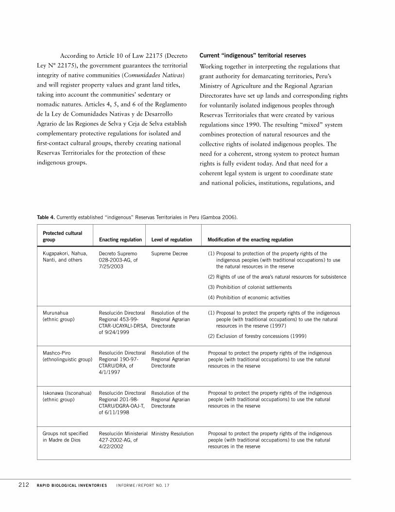
According to Article 10 of Law 22175 (Decreto
Ley N° 22175), the government guarantees the territorial
integrity of native communities (Comunidades Nativas)
and will register property values and grant land titles,
taking into account the communities’ sedentary or
nomadic natures. Articles 4, 5, and 6 of the Reglamento
de la Ley de Comunidades Nativas y de Desarrollo
Agrario de las Regiones de Selva y Ceja de Selva establish
complementary protective regulations for isolated and
first-contact cultural groups, thereby creating national
Reservas Territoriales for the protection of these
indigenous groups.
Current “indigenous” territorial reserves
Working together in interpreting the regulations that
grant authority for demarcating territories, Peru’s
Ministry of Agriculture and the Regional Agrarian
Directorates have set up lands and corresponding rights
for voluntarily isolated indigenous peoples through
Reservas Territoriales that were created by various
regulations since 1990. The resulting “mixed” system
combines protection of natural resources and the
collective rights of isolated indigenous peoples. The
need for a coherent, strong system to protect human
rights is fully evident today. And that need for a
coherent legal system is urgent to coordinate state
and national policies, institutions, regulations, and
212 RAPID BIOLOGICAL INVENTORIES INFORME / REPORT NO. 17
Protected cultural group Enacting regulation Level of regulation Modification of the enacting regulation
Kugapakori, Nahua, Nanti, and others
Murunahua (ethnic group)
Mashco-Piro (ethnolinguistic group)
Iskonawa (Isconahua)(ethnic group)
Groups not specified in Madre de Dios
(1) Proposal to protection of the property rights of theindigenous peoples (with traditional occupations) to use the natural resources in the reserve
(2) Rights of use of the area’s natural resources for subsistence
(3) Prohibition of colonist settlements
(4) Prohibition of economic activities
(1) Proposal to protect the property rights of the indigenouspeople (with traditional occupations) to use the naturalresources in the reserve (1997)
(2) Exclusion of forestry concessions (1999)
Proposal to protect the property rights of the indigenous people (with traditional occupations) to use the naturalresources in the reserve
Proposal to protect the property rights of the indigenous people (with traditional occupations) to use the naturalresources in the reserve
Proposal to protect the property rights of the indigenous people (with traditional occupations) to use the naturalresources in the reserve
Decreto Supremo028-2003-AG, of7/25/2003
Resolución DirectoralRegional 453-99-CTAR-UCAYALI-DRSA, of 9/24/1999
Resolución DirectoralRegional 190-97-CTARU/DRA, of4/1/1997
Resolución DirectoralRegional 201-98-CTARU/DGRA-OAJ-T,of 6/11/1998
Resolución Ministerial 427-2002-AG, of4/22/2002
Supreme Decree
Resolution of theRegional AgrarianDirectorate
Resolution of theRegional AgrarianDirectorate
Resolution of theRegional AgrarianDirectorate
Ministry Resolution
Table 4. Currently established “indigenous” Reservas Territoriales in Peru (Gamboa 2006).

procedures that protect and enforce the interests and
collective rights of isolated indigenous peoples. Five
“indigenous” territorial reserves exist in Peru, under
various laws (Table 4).
With the exception of the Reserva Territorial
for the “Kugapakori, Nahua, Nanti, and others”—which
was elevated to the level of “Supreme Decree” because of
political motives related to the Camisea Gas energy
project—there has been no fundamental protection
specifically for the benefit of isolated indigenous peoples
created anywhere in Peru. The only measure regulating
the need to establish legislative and administrative
procedures to protect the rights of isolated indigenous
peoples was Supreme Decree 013-2001-PROMUDEH.
This decree charged the Secretaria Técnica de Asuntos
Indígenas (SETAI, “Technical Office of Indigenous
Affairs”), of the then-Ministerio de la Mujer y del
Desarrollo Humano (“Ministry of Women and Human
Development”), with overseeing and ensuring respect
toward, and rights of, voluntarily isolated and first-
contact indigenous peoples in all actions undertaken by
the Departments of (1) agriculture; (2) industry, tourism,
and international commercial negotiations; (3) energy
and mines; (4) health; (5) education; (6) defense; and
(7) fisheries. SETAI was also responsible for outlining a
policy of intervention to guarantee the rights of these
indigenous peoples.
With the creation of the Comisión Nacional
de los Pueblos Andinos, Amazónicos y Afroperuanos
(CONAPA)—assigned to the Presidencia del Consejo de
Ministros—SETAI, which initially oversaw CONAPA,
was dissolved and its functions were assumed by the
Executive Secretary of CONAPA. Subsequently CONAPA
was deactivated and now the Instituto Nacional de
Desarrollo de los Pueblos Indígenas, Amazónicos y
Afroperuano (INDEPA) assumes the job of creating a
system of protection for the isolated indigenous peoples
(Art. 13, Law 28495 of 6 April 2005).
Official state recognition of the vulnerability of
voluntarily isolated indigenous peoples
The Defensoría (“Defense Council”) del Pueblo del Perú
published Report 101 (Resolución Defensorial N° 032-
2005-DP), entitled Pueblos Indígenas en Situación de
Aislamiento Voluntario y Contacto Inicial. The reports
mentions an estimated 14 ethnic groups in vulnerable
situations (with regard to life, health, property, and use
of natural resources). Principal threats come from
mining and oil operations, legal and illegal logging,
tourism, drug trafficking, and others. The report also
identified economic activities—in particular oil
exploitation—that will have a serious negative impact
on these isolated indigenous peoples (Table 5).
Report 101 determined that, despite the
establishment of Reservas Territoriales, economic
activities continued unimpeded, having a negative effect
on the life, health, and physical integrity of the
indigenous peoples, as well as destroying their territorial
PERÚ: SIERRA DEL DIVISOR DICIEMBRE / DECEMBER 2006 213
Cultural group Lot /Principal operator /Status
Kugapakori, Nahua, and Kirineri Lot 88/Pluspetrol, TGP, and Hunt Oil,
Cusco/Exploitation license active; and
Lot 57/Repsol, Cusco Ucayali/Exploitation license active
Arabela, Auca (Huaorani) Lot 39/Repsol, Loreto/Exploitation license active; and
Lot 67/Barret, Loreto/Exploitation license active
Murunahua Lot 110/Petrobrás, Ucayali/Exploitation license
Isolated indigenous peoples of Lot 113/Sapet/Exploitation license active
Madre de Dios
Table 5. Impact of oil exploitation activities (Gamboa 2006).

rights, cultural identities, and natural resources. The
report proposed the creation of special regulation to
give genuine and full protection for voluntarily isolated
indigenous peoples (Table 6).
“Special Protection” regulations
As of 2005, the vulnerable status of voluntarily isolated
and first-contact indigenous peoples, brought to public
attention through the Camisea Gas project and the
social and economic problems of the Peruvian Amazon,
resulted in the confirmation of a special commission
formed by representatives of the Ministries of
agriculture, health, defense, foreign relations, energy
and mines, transportation, and communication, as well
as “The Defense Council of the People” (la Defensoría
del Pueblo), with INDEPA as president of the
commission. Also participating were representatives of
the farm-labor and Amazon associations, AIDESEP and
the Confederación de Nacionalidades Amazónicas del
Perú (CONAP). The commission was created by Supreme
Decree 024-2005-PCM, which formulated a “Draft Bill
for the Protection of Voluntarily Isolated or First-Contact
Indigenous Peoples.”
Subsequently, the presidency of the Council
of Ministers (Consejo de Ministros), through
communication 078-2005-PCM, presented the proposal
developed by the “Comisión Especial del Consejo de
Ministros to the Comisión de Amazonía, Asuntos
Indígenas y Afroperuanos” of the Peruvian Congress.
The Congressional Commission (through the
Decision of Bill 13057) proposed the “Law for the
Protection of Voluntarily Isolated and First-Contact
Indigenous Peoples,” which modifies and limits the
special-protection regulations for these groups presented
by the Special Commission. The two proposals for laws
were radically different: a “Draft Bill on Special
Regulations for the Protection of Voluntarily Isolated
and First-Contact Indigenous Peoples” developed by the
Comisión Especial del Poder Ejecutivo (Supreme Decree
024-2005-PCM), and Decision 13057, the “Law for the
Protection of Voluntarily Isolated and First-Contact
Indigenous Peoples.” The second proposal weakens the
first because it eliminates (1) the transectorial obligations
of the government; (2) the institutionality of the
regulations (through the lack of a named director);
(3) the “Procedures of Protection,” and (4) the
“Proposal of Transectorial Protection.”
In 2005, the new Comisión de Pueblos
Andinoamazónicos, Afroperuanos, Ecología y Ambiente
del Congreso de la República petitioned the Consejo
Directivo (“Managing Council”) to withdraw Decision
13057 for further study by that Commission.
A communication on October 4 and 5 of 2005 from
indigenous organizations (AIDESEP and CONAP) and
NGOs (WWF, DAR, IBC, Shinai, Racimos), requesting
that the legislative process of Decision 13057 be
detained, was successful. Unfortunately, the Comisión de
Pueblos Andinoamazónicos, Afroperuanos, Ecología y
214 RAPID BIOLOGICAL INVENTORIES INFORME / REPORT NO. 17
Cultural group Activities harming isolated indigenous groups
Kugapakori, Nahua, Nanti, and others Lot 88 of Gas de Camisea’s Proyecto Energético
Murunahua (ethnic group) Logging concessions and illegal logging
(exclusion of the area by INRENA)
Mashco-Piro (ethnolinguistic group) Logging concessions and illegal logging
Iskonawa (Isconahua) (ethnic group) Logging concessions and illegal logging
Groups not identified in Madre de Dios Logging concessions and illegal logging
(exclusion of the area by INRENA)
Table 6. Territorial Reserves Created to Date (Gamboa 2006).

Ambiente del Congreso de la República did
not discuss this decision until the end of November,
making approval of any regulation or law benefiting
these groups in the year 2005 impossible. Not until 30
November 2005 did Commission advisors present the
by-then merged Comisión de Pueblos Andinoamazónicos,
Afroperuanos, Ecología y Ambiente with a pre-decision
on these special regulations. The new text eliminated the
initially proposed Special Regulations by the Comisión
del Poder Ejecutivo (created by Supreme Decree 024-
2005-PCM); however, it retains the inviolable character
of the Reservas Territoriales (e.g., prohibiting settlements
other than those of the isolated groups and explicitly
prohibiting “the granting of rights that would imply the
surrendering of natural resources”). The shortcomings of
this proposal include (1) the lack of clarity on the issue
of special regulations of protection, which are made
transitory until these isolated peoples enter into
voluntary contact with mainstream society; (2) the
establishment of two complex procedures to protect
these peoples (one to prove their existence and another
to create a territorial reserve); and (3) the setting of time
limits for the Reservas Territoriales, to be stated in the
Supreme Decrees that create the Reserves. With arbitrary
limits of five, ten, or fifteen years for strict protection,
the intrusion of activities harmful to the rights of these
isolated peoples becomes possible in the near future.
AIDESEP and other organizations (WWF,
IBC, DAR, Racimos, Shinai) developed diverse strategies
to speak with and educate members of the Peruvian
Congress, both in the Commission and in the full
Congress. The goal is to regulate economic activities—
from extractive economies to the sustainable
exploitation of natural resources—that would infringe
on the human rights of the isolated indigenous peoples.
International legislation that protects these indigenous
peoples could impose international sanctions on Peru,
such as those indicated in the ruling of the Interamerican
Court in Awas Tigni vs. Nicaragua, which prohibits
Nicaragua from granting natural resource concessions
without recognizing the ancestral and historic property
rights of indigenous communities.
Current legislative status
On 13 December 2005, the Comisión de Pueblos
Andinoamazónicos, Afroperuanos, Ecología y Ambiente
finally approved Decision 13057, which substantially
kept intact the “Special Regulations for the Protection
of Voluntarily Isolated and First-Contact Indigenous
Peoples.” However, we make two observations below:
� Some elements of the legislation are from the original
proposed draft bill of the Comisión Especial del Poder
Ejecutivo (created by Supreme Decree 024-2005-PCM),
in which national institutions (the ministries of energy
and mines, health, external relations, and agriculture—
MINEN, MINSA, MRE, MINAG, INRENA) and
indigenous organizations (AIDESEP and CONAP)
participated. This version is certainly better than the
previous one (of 24 June 2005). Among the recovered
elements are (1) the transectorial nature of the
regulations; (2) the clear obligation of the government
toward the isolated indigenous peoples; and (3) the
inviolable character of the territorial reserves (with
prohibition against the establishment of colonist
settlements and economic activities).
� Among the problems in the text is (1) the elimination
of the injunction to penalize unauthorized incursions
into the territorial reserves. This elimination weakens
the preventive and protective measures of the original
regulations. (2) Time limits have been established for
the indigenous territorial reserves, “renewable
indefinitely as often as necessary.” However, the
intercultural criterion that the reserves be maintained
until the isolated groups decide to initiate contact has
not been retained, (3) nor has the regulatory decree
indicating “that rights acquired by third parties or
economic activities in progress at the time a territorial
reserve is established must conform to the objectives
and resolutions of the Régimen Especial de
Protección, to this law, and to its rules.”
Other elements in this version are dangerous,
for example, the intention to reduce Reservas Territoriales
because of their overlap with the rights of third parties,
logging grants, or other exploitation rights; even in cases
PERÚ: SIERRA DEL DIVISOR DICIEMBRE / DECEMBER 2006 215

of overlap with “permanent production forests” that
represent a type of “economic-ecologic zoning” but not
an exploitation right. We must prevent the reduction of
areas of protection for these cultural groups.
The Decision 13057 was approved by the
full Congress in March 2006. It was promulgated as
Law 28736, which entered into force on 19 May 2006.
This law created the “special transectorial regulations to
protect voluntary isolated and first-contact indigenous
peoples.” However, it still needs to be modified, or,
through regulations, made to be stronger to provide
strict protection for isolated indigenous peoples. The
group led by AIDESEP and composed by WWF, Shinai,
Racimos, DAR, and IBC continue to work on a proposal
of modification of the law while simultaneously working
on regulations that would strengthen the current law.
Final comments
The objective of these special regulations is to clarify
the duality of the legal discourse: (1) to recognize the
full rights of isolated indigenous peoples and (2) to
protect them effectively from any social, economic,
cultural, or political interference that would harm them,
as has occurred multiple times in the past, with the
rubber-tappers, Shining Path (Sendero Luminoso),
Armed Forces, settlers, or even other native communities.
We should emphasize that constitutional and legal
protection of the rights of indigenous peoples, and the
exercising of these rights, must be in accordance with
respect for human rights, as dictated by the
Constitution and, where appropriate, by law. While it
is important to create special regulations for the
protection of voluntarily isolated indigenous peoples and
to work out a clause of constitutional agreement that
contains a “legal, constitutional benefit” that respects
our legal system, it is just as critical that this framework
of protection seek to establish an utterly fair and
straightforward intercultural dialogue between the
socially dominant culture and the Andean or
Amazonian one, which has been dominated for
centuries. Perhaps these regulations will give a new start
to identities based on the notion that Mariategui
designated “Peruvianness” (peruanidad).
This is an opportunity that history has
granted us as a national society to value and celebrate
the diverse cultures that enrich Peru.
216 RAPID BIOLOGICAL INVENTORIES INFORME / REPORT NO. 17