Scottish Sea Kayak Trail by Simon Willis, sample.
24
SCOTTISH SEA KAYAK TRAIL A voyage of 500km along Scotland’s spectacular west coast described in detail. How to tackle the entire journey or break it into holiday-length sections. SIMON WILLIS
-
Upload
pesda-press -
Category
Documents
-
view
224 -
download
1
description
This book challenges you to kayak a 500km route, from the Isle of Gigha off the Kintyre peninsula, to the Summer Isles near Ullapool. It can be undertaken in four holiday-sized sections or as one long, glorious journey.The emphasis is on practical advice; how to tackle tricky tidal passages; places to visit; where to source essential information; food re-supply; where to safely leave kayaks overnight; how and when to shuttle vehicles; and the accessibility of public transport. Although camping is an essential element of this journey the book does not identify wild camp sites or even picnic places. It gives sea kayakers enough information to seek out their own adventures and so spread the environmental impact.
Transcript of Scottish Sea Kayak Trail by Simon Willis, sample.

ScottiShSea KayaK
trailA voyage of 500km along Scotland’s spectacular west coast described in detail. How to tackle the entire journey or break it into holiday-length sections.
SIMON WILLIS
NORT HLANDS
SWIF T WAT ERSFLOWING
BIG MO UNTAINSBIG SEASBIG SEAS
LORDSOF T HE ISLES
Tayinloan
Kilberry
Carsaig
Clachan Bridge
Crinan
Oban
1.1
1.2
1.3
1.4
1.5
1.6
2.12.2
2.32.4
2.5
2.6
2.7
2.82.9 2.10
2.11
2.12
Craignure
Lochaline
Tobermory
Kilchoan
Sanna Ardtoe
Glenuig
Arisaig
Mallaig
3.1
3.2
3.3
3.4
Doune
Glenelg
4.1
4.2
4.3
4.44.5
Kyle of Lochalsh
Applecross
Gairloch
UllapoolMellonUdrigle
SKYE
RUM
Canna
JURA
KerreraKerreraKerreraMULL
Eilean ShonaEilean ShonaEilean Shona
Sandaig IslandsSandaig IslandsSandaig IslandsSandaig IslandsSandaig IslandsSandaig Islands
Coll
TireeTiree
ISLAY
ColonsayColonsay
Gigha
RaasayRaasayRaasay
Summer Isles

ScottiShSea KayaK
trail
SIMON WILLIS

First published 2009
Published in Great Britain 2009 by Pesda Press
Unit 22, Galeri
Doc Victoria
Caernarfon
Gwynedd
LL55 1SQ
© Copyright 2009 Simon Willis
ISBN: 978−1−906095−17−8
The Author asserts the moral right to be identified as the author of this work.
All rights reserved. No part of this publication may be reproduced,
stored in a retrieval system, or transmitted, in any form or by
any means, electronic, mechanical, photocopying, recording or
otherwise, without the prior written permission of the Publisher.
Printed and bound in Poland. www.polskabook.pl

To Liz,
for opening up a new world.
WarningSea kayaking is inherently a potentially dangerous sport. With this considered, users of
this guide should take the appropriate precautions before putting to sea.
the information supplied in this book has been thoroughly researched; however the
author can take no responsibility if tidal times differ or if the information supplied is not
sufficient to negotiate the conditions experienced on the day. conditions can change
quickly and dramatically on the sea and there is no substitute for utilising personal
experience and good judgement when kayaking or (arguably even more importantly)
whilst planning a sea trip.
the guide is no substitute for personal ability, personal risk assessment and good judge-
ment. remember that the outdoors cannot be made risk free and that you should plan
and act with care at all times for your own safety and that of others. the decision on
whether to go out sea kayaking or not, and any consequences arising from that deci-
sion, remain yours and yours alone.

ContentsForeword ............................................................. 9
Preface ...............................................................11
about Simon and liz . . . . . . . . . . . . . . . . . . . . 13
About the Trail . . . . . . . . . . . . . . . . . . . . 17
the sections. . . . . . . . . . . . . . . . . . . . . . . . . . . . 18
Planning your Trip . . . . . . . . . . . . . . . 21
When to go . . . . . . . . . . . . . . . . . . . . . . . . . . . . . 21
logistics . . . . . . . . . . . . . . . . . . . . . . . . . . . . . . . 23
tidal streams . . . . . . . . . . . . . . . . . . . . . . . . . . . 25
Weather and forecasts . . . . . . . . . . . . . . . . . . 26
Maps, charts and guidebooks . . . . . . . . . . . 29
Gaelic for sea kayakers . . . . . . . . . . . . . . . . . . 31
Map legend . . . . . . . . . . . . . . . . . . . . . . . . . . . . . 31
Safety & Equipment . . . . . . . . . . . . 35
Boat and paddle . . . . . . . . . . . . . . . . . . . . . . . . 35
clothing on the water . . . . . . . . . . . . . . . . . . . 36
clothing off the water . . . . . . . . . . . . . . . . . . . 36
Safety . . . . . . . . . . . . . . . . . . . . . . . . . . . . . . . . . 37
raising the alarm . . . . . . . . . . . . . . . . . . . . . . . 38
rescue . . . . . . . . . . . . . . . . . . . . . . . . . . . . . . . . 39
Overnight . . . . . . . . . . . . . . . . . . . . . . . . . . 43
Finding accommodation . . . . . . . . . . . . . . . . . 43
Wild camping & Scottish law . . . . . . . . . . . . 44
camp craft . . . . . . . . . . . . . . . . . . . . . . . . . . . . . 45
camping equipment . . . . . . . . . . . . . . . . . . . . . 46
Food and water . . . . . . . . . . . . . . . . . . . . . . . . . 48
Wildlife . . . . . . . . . . . . . . . . . . . . . . . . . . . . . 51
avoiding disturbance . . . . . . . . . . . . . . . . . . . . 51
Birds. . . . . . . . . . . . . . . . . . . . . . . . . . . . . . . . . . . 52
Seals . . . . . . . . . . . . . . . . . . . . . . . . . . . . . . . . . . 54
Basking sharks . . . . . . . . . . . . . . . . . . . . . . . . . 56
cetaceans . . . . . . . . . . . . . . . . . . . . . . . . . . . . . 57
otters . . . . . . . . . . . . . . . . . . . . . . . . . . . . . . . . . . 59
turtles . . . . . . . . . . . . . . . . . . . . . . . . . . . . . . . . . 60
recording sightings . . . . . . . . . . . . . . . . . . . . . . 61
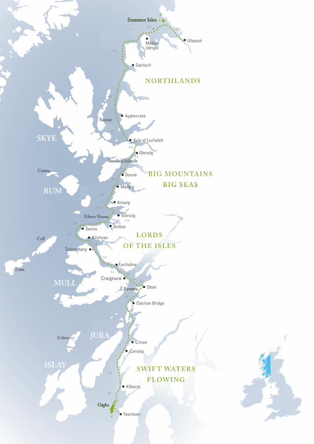
Section 1:Swift Waters Flowing . . . . . . . . . 63
1.0 Gigha Ferry slipway . . . . . . . . . . . . . . . . . 63
1.1 to Gigha . . . . . . . . . . . . . . . . . . . . . . . . . . . 64
1.2 to Kilberry head . . . . . . . . . . . . . . . . . . . . 66
1.3 to carsaig Bay . . . . . . . . . . . . . . . . . . . . . 68
1.4 to crinan . . . . . . . . . . . . . . . . . . . . . . . . . . 72
1.5 to clachan Bridge . . . . . . . . . . . . . . . . . . 74
1.6 to oban . . . . . . . . . . . . . . . . . . . . . . . . . . . . 77
Shuttle information . . . . . . . . . . . . . . . . . 80
Co
nt
en
ts
Section 2:Lords of the Isles . . . . . . . . . . . . . . . 85
2.0 oban . . . . . . . . . . . . . . . . . . . . . . . . . . . . . . 85
2.1 to Kerrera . . . . . . . . . . . . . . . . . . . . . . . . . 86
2.2 to Duart castle . . . . . . . . . . . . . . . . . . . . . . 87
2.3 to craignure . . . . . . . . . . . . . . . . . . . . . . . 90
2.4 to lochaline . . . . . . . . . . . . . . . . . . . . . . . . 91
2.5 to tobermory . . . . . . . . . . . . . . . . . . . . . . . 93
2.6 to Kilchoan . . . . . . . . . . . . . . . . . . . . . . . . 95
2.7 to Sanna Bay . . . . . . . . . . . . . . . . . . . . . . . 97
2.8 to ardtoe . . . . . . . . . . . . . . . . . . . . . . . . . 102
2.9 to eilean Shona . . . . . . . . . . . . . . . . . . . 103
2.10 to Glenuig . . . . . . . . . . . . . . . . . . . . . . . . 104
2.11 to arisaig . . . . . . . . . . . . . . . . . . . . . . . . . 105
2.12 to Mallaig . . . . . . . . . . . . . . . . . . . . . . . . 107
Shuttle information . . . . . . . . . . . . . . . . 109
Section 3:Big Mountains, Big Seas . . . . 113
3.0 Mallaig . . . . . . . . . . . . . . . . . . . . . . . . . . . 113
3.1 to Doune. . . . . . . . . . . . . . . . . . . . . . . . . . 115
3.2 Sandaig islands . . . . . . . . . . . . . . . . . . . 118
3.3 to Glenelg . . . . . . . . . . . . . . . . . . . . . . . . 120
3.4 to Kyle of lochalsh . . . . . . . . . . . . . . . . . 121
Shuttle information . . . . . . . . . . . . . . . . 124
Section 4:Northlands . . . . . . . . . . . . . . . . . . . . . . . 129
4.0 Kyle of lochalsh . . . . . . . . . . . . . . . . . . . 129
4.1 to applecross . . . . . . . . . . . . . . . . . . . . . . 131
4.2 to Gairloch . . . . . . . . . . . . . . . . . . . . . . . . 134
4.3 to Mellon Udrigle . . . . . . . . . . . . . . . . . . 137
4.4 to the Summer isles . . . . . . . . . . . . . . . 142
4.5 to Ullapool . . . . . . . . . . . . . . . . . . . . . . . . 144
Shuttle information . . . . . . . . . . . . . . . . 146
Co
nt
en
ts

Liz and Simon in the shallows of Loch Moidart near their home (page 103). Photo | Daniel Mitchell.


9
ForewordScotland’s west coast, together with the Hebrides and the Northern Isles, constitutes one of the best recreational sea-kayaking environments in the world. This explains why people have been paddling there for almost 140 years and the first circumnavigation of the mainland, from the Solway to the Tyne, took place over a century ago. Those early canoeists ventured into the exciting and challenging waters in craft not all that different from the sea kayaks of today, but without the benefits of purpose-designed clothing, buoyancy aids, dry suits and certainly without guidebooks. A relative newcomer, Simon took up sea kayaking in 2003 as an experienced outdoor man and hill-walker escaping the overcrowded hills. Like others from a similar background, he has found sea kayaking to have many advantages. The ability to practice his new-found skills in magnificent scenery combines well with photography and the enjoyment of a varied wildlife; from seals and whales to sea birds, otters and deer.Simon brings with him an enthusiasm and a desire to pass on the benefits of his experiences to others. Sea kayaking is currently enjoying a tremendous surge in numbers of participants. This, combined with the pace of modern life and its demand for instant information, if not at the touch of a button at least at the turn of a page, gives Simon the raison d’être for his guide. The Scottish Sea Kayak Trail contains almost all the practical knowledge required for the recommended trips.While this book provides much valuable information, it should be regarded as just another item of equipment for the paddler and cannot replace good judgement. What is missing, quite deliberately, is the string of pearls along the trail. The identification of each perfect beach or campsite would create a honey pot effect and be bad for the environment. It is better by far to enjoy the spirit of adventure and find your own pearls. There is no better place in the world to look than along the Scottish Sea Kayak Trail.
Duncan r. Winning oBe. honorary PreSiDent, ScottiSh canoe aSSociation.

10
11
PrefaceIt is the long journey that captures my imagination. While I’ve bagged my share of summits, I’ve always preferred the long-distance through-route to ticking off another top. Whether I’ve been carrying a rucksack or pedalling a bike, I have usually chosen the long way around.In 2002 I walked the length of the United States of America. Together with Liz, who subsequently agreed to marry me, we crossed baking deserts and snow-choked mountain passes following the 2,658 mile Pacific Crest Trail. That journey changed our lives in ways we are still discovering. After five months continuous backpacking, we wanted to try a new sport, and turned to sea kayaking because it has the sense of journeying we enjoy so much. Since then kayaking has become a major part of our lives. We have spent most of our free time exploring Scotland’s west coast. We changed jobs and moved house to be closer to a prime kayaking area. Spending a summer paddling the length of the coast, so I could write this book, was an obvious progression.So if you choose to undertake this long kayak journey, expect to move and think at a different pace. When things go wrong, the way you cope will be yet another part of the adventure.I cannot guarantee the Scottish Sea Kayak Trail will change your life. But it might.
Simon Willis

12

13
About simon and LizThousands of sea kayakers around the world know Simon’s voice from his podcast website (SeaKayakRoutes.com) and through his work as a correspondent with the BBC. Liz was tackling a series of unclimbed peaks in Alaska when she met Simon and kept him on track when they hiked the length of the USA together, following the 2,658 mile wilderness Pacific Crest Trail from Mexico to Canada. After five months backpacking, they turned to sea kayaking and became passionate advocates for the sport. They moved house and switched jobs so they could live and kayak on Scotland’s west coast. Simon makes adventure films and shoots videos for businesses. He contributes travel articles to newspapers, such as The Sunday Times and The Herald, as well was writing for specialist magazines. His work has appeared in all the UK’s kayaking magazines. Liz continues to keep Simon on track and endures being photographed more than most kayakers.

1 12
Skye’s controversial bridge (page 119).
The Jacobite doubles as the Hogwarts Express (page 113). Mallaig harbour (page 113).
Early morning in Sound of Sleat (page 117).
Crossing Loch’s heaven and hell (page 115).
1 13
Big
Mo
un
ta
ins,
Big
se
as
3.0
3.1
3.2
3.3
3.4
3.1
3.2
3.3
3.4
Mallaig
Doune
Sandaig IslandsGlenelg
Kyle of Lochalsh
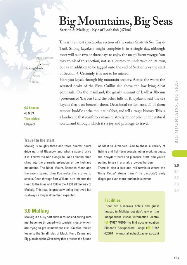
Big Mountains, Big seassection 3: Mallaig – Kyle of Lochalsh (47km)
Travel to the startMallaig is roughly three and three quarter hours
drive north of Glasgow, and what a superb drive
it is. Follow the A82 alongside Loch Lomond, then
climb into the dramatic splendour of the highland
mountains. The Black Mount, Rannoch Moor, and
the awe inspiring Glen Coe make this a drive to
savour. Once through Fort William, turn left onto the
Road to the Isles and follow the A830 all the way to
Mallaig. This road is gradually being improved but
is always a longer drive than expected.
3.0 Mallaig Mallaig is a busy port all year round and during sum-
mer becomes thronged with tourists, most of whom
are trying to get somewhere else. CalMac ferries
leave to the Small Isles of Muck, Rum, Canna and
Eigg, as does the Skye ferry that crosses the Sound
of Sleat to Armadale. Add to these a variety of
fishing and fish-farm vessels, other working boats,
the Knoydart ferry and pleasure craft, and you’re
putting to sea in a small, crowded harbour.
There is also a bus and rail terminus where the
‘Harry Potter’ steam train (‘The Jacobite’) daily
disgorges even more tourists in summer.
OS Sheets:
40 & 33
Tide tables:
Ullapool
This is the most spectacular section of the entire Scottish Sea Kayak Trail. Strong kayakers might complete it in a single day, although most will take two or three days to enjoy the magnificent voyage. You may think of this section, not as a journey to undertake on its own, but as an addition to be tagged onto the end of Section 2 or the start of Section 4. Certainly, it is not to be missed. Here you kayak through big mountain scenery. Across the water, the serrated peaks of the Skye Cuillin rise above the low-lying Sleat peninsula. On the mainland, the gnarly summit of Ladhar Bheinn (pronounced ‘Larven’) and the other hills of Knoydart dwarf the sea kayaks that pass beneath them. Occasional settlements, all of them remote, huddle at the mountains’ feet, and tell a tragic history. This is a landscape that reinforces man’s relatively minor place in the natural world, and through which it’s a joy and privilege to travel.
FacilitiesThere are numerous hotels and guest
houses in Mallaig, but don’t rely on the
independent visitor information centre
(p 01687 462064) to find accommodation.
Sheena’s Backpackers’ Lodge (p 01687
462764 www. mallaig backpackers.co.uk)
3.0

1 1 4
Big
Mo
un
ta
ins,
Big
se
as
3.0
3.1
3.2
3.3
3.4
is near the harbour, tucked above a busy
café with a lovely outdoor terrace. Imme-
diately opposite is a medium supermarket
with a small – medium supermarket up a
neighbouring street, but if you’re driving
here, it’s better value to buy supplies in the
larger town of Fort William. Johnston Bros
chandlery is on the pier (p 01687 462215).
After they park their cars, The Small Isles’
residents seem to wait for the return
ferry in the café of the Fishermen’s Mis-
sion (p 01687 462086), home to ‘The best
value food in Lochaber’, it has been said.
It offers excellent cooked breakfasts until
11.30am, as well as scones, rolls and hot
meals until 9pm during the week and until
12pm on Saturdays. They have showers
and a laundry service. The outside of the
building is rather austere and the inside
functional rather than appealing, but the
staff in this Christian charity café are
friendly and helpful.
Among all the activity, there’s only one convenient
place to launch a sea kayak and that’s from the
slipway in the south-east corner of the harbour. If
you’re starting the trail in Mallaig, then, as you drive
into the town, turn right at the mini-roundabout,
pass the visitor information centre and, as you pass
some public toilets on the left, immediately pull into
Two views of Mallaig harbour showing the slipway.
one of the short-stay parking bays to unload. The
slipway is directly in front. Once the kayaks and kit
are safely on the slipway, drive further along the
seafront and leave the vehicle in one of the long-
stay parking bays, or head back to the mini rounda-
bout, turn left, then right by the police station into
another large car-park. Signs in this one proclaim
‘No Overnight Parking’, but residents of The Small
Isles tend to leave their vehicles here for weeks on
end. If you want to be certain your vehicle is cor-
rectly parked, pass on the details to Mallaig police
station (p 01687 462177).
Mallaig – Armadale
Mallaig – Small Isles
0 0.5km
0 0.25mls
Mallaig
Chandlers
Fishermans’sMission
3.0

1 15
Big
Mo
un
ta
ins,
Big
se
as
3.0
3.1
3.2
3.3
3.4
Western Isles, and Loch Nevis offered deep,
sheltered water. However, a study of the mountain
landscape concluded it would be too difficult and
costly for a railway line to be cut to Loch Nevis
so, despite objections in Parliament that Mallaig
would never make a safe harbour, it was chosen
as the terminus.
So keen were crofters for the railway to come
through, four hundred of them offered to work on
its construction and devote a sixth of their wages
to buying shares in the scheme. Although growth
was limited by its location, squeezed between the
railway and the sea, Mallaig boomed.
Additional informationThere was a time in the early 1900s when, it is said,
you could walk across Mallaig harbour without
getting your feet wet. So many fishing boats were
crammed behind the harbour wall, men would reach
the shore by stepping from deck to deck. With up to
nine men on each vessel, Mallaig was jumping with
activity. Previously there had been only a handful of
crofts here, huddled at the end of a forty-mile long
rough track, until the railway arrived in 1901.
It nearly went somewhere else. Loch Nevis was
initially the favoured site for the railway terminal.
The west highland line had to reach the sea to
bring back the fish caught off the Skye and the
Cloven hoofed locusts
The failed rebellion of 1745 had far-reaching and long-lasting consequences. Clan chiefs who had
risen against the crown forfeited their lands and, in so doing, lost much of their power. Absentee
landowners took over, caring little for the people who lived on their estates, focused only on an
economic return.
New hardy breeds of sheep appeared around 1760 and, gradually, the best land was given over
to these animals. Human communities were pushed onto less fertile land where they clustered
around the few spots where food would grow, turning these places into increasingly squalid town-
ships. Some were offered free passage to Australia and Canada. When the 1845 potato famine hit,
many were only too keen to sail away. The cruel irony was that people were starving at one end of
the Glen, while at the other sheep enjoyed the fertile land. This was the Highland Clearances.
3.1 To Doune – (10km)Wait until the large fishing vessels have stopped
moving in the harbour, and with the VHF handy
and tuned to Channel 16, leave quickly through
the maze of pleasure craft, keeping close to the
east shore. Your view will immediately be drawn
to the mountains of the Skye Cuillin, which rise
behind the bulk of the low-lying Sleat peninsula
(pronounced ‘Slate’). Even better views lie around
the corner. Keeping close to the coast, turn east
into Loch Nevis and gaze up at the imposing moun-
tains of Knoydart. This area suffered badly during
the Highland Clearances with thousands of people
evicted from their homes.
There is still no road into Knoydart, but the commu-
3.0
3.1

1 16
Big
Mo
un
ta
ins,
Big
se
as
3.0
3.1
3.2
3.3
3.4
No short cut
We tried cutting directly across the mouth of Loch Nevis to Glas Eilean. However, the south-
westerly wind whipped up a surprisingly large beam sea, so we went with the waves, travelling a
couple of kilometres east of Sron Raineach before heading across to shelter on the other side. We
quickly found a campsite and by morning the sea was calm.
nity is recovering well. If you have time, the 12km
diversion to visit Britain’s most remote pub, The Old
Forge at Inverie (p 01687 462267, www.theoldforge.
co.uk) is recommended.
The trail reaches the cliffs of Sron Raineach,
swings due north across the wide mouth of Loch
Nevis, and makes the crossing, first to Glas Eilean
and then to Eilean Dearg. Like Loch Hourn further
north, the mouth of Loch Nevis can be fearsomely
rough. Sudden squalls blow down from the moun-
tains and whip an otherwise moderate sea into a
fury. If you need shelter, it can often be found in
Sandaig Bay, not to be confused with the Sandaig
Islands further north.
Continue around the steep coastline with no exits
until you can escape into the bay at Doune.
DirectionsLeave Mallaig, keeping close to the east shore
and curve around into Loch Nevis as far as Sron
Raineach. Tidal streams are weak across the wider
part of Loch Nevis and Sound of Sleat. Off route, in
the narrows heading for Inverie, they reach 0.5kn
at springs and there’s a good detour into Inverie.
If conditions permit, cross directly to Glas Eilean,
then to Eilean Dearg. Follow the steep coastline
around and escape into the bay at Doune.
Facilities A remote, rustic hotel is located at Doune
and, provided you book in advance for din-
ner, the owners welcome sea kayakers to
camp in the bay. Under Scottish access
legislation, you should seek permission if
you wish to wild camp within sight of peo-
ple’s houses; so talk to the hotel owners
before you set camp in this bay. (p 01687
462667, www.doune-knoydart.co.uk)
Rubha Raonuill
An Fhaochag K N O Y D A R T
Loch Nevis
SOU
ND
OF
SLE
AT
0 2km
0 1mls
Mallaig
+05
35 H
W U
llap
oo
l –
0025
HW
Ulla
po
ol
+0515 HW Ullapool
–0105 HW Ullapool
0.5kn SP
Doune
Inver ieBay
SandaigBay
3.1

1 1 7
Big
Mo
un
ta
ins,
Big
se
as
3.0
3.1
3.2
3.3
3.4
Loch Nevis In stream starts +0515 HW Ullapool
Out stream starts −0105 0.5kn springs in narrows
Sound of Sleat NE stream starts +0535 HW Ullapool
SW stream starts −0025 1kn springs
Additional informationThe great mountain landscape of the Knoydart is
frequently described as a wilderness yet, less than
two hundred years ago, more than a thousand
people lived in stone houses along the edge of
the sea lochs where they survived by farming and
fishing. Knoydart is one of the parts of Scotland
where the clearances were ruthlessly effective
with almost every family being removed to make
way for sheep.
Today, much of the peninsula is owned by the Knoy-
dart Foundation, a partnership of local residents,
council and trusts. Although only accessible by boat,
the sole village, Inverie, has a growing population of
around one hundred people. There is a post office,
primary school, B&Bs, bunkhouse and inn.
Knoydart cleared
During the Highland Clearances, the large Knoydart estate was under the management of trus-
tees, its owner having died while his son was too young to assume the responsibility of running
the estate. People had been gradually cleared from the estate when, in 1853, the trustees decided
to evict them all.
More than three hundred people decided to accept the offer of free passage to Canada on board
the Sillery, under the condition that their homes were demolished. Those crofters who refused to
emigrate were evicted and their houses destroyed. Around thirty people, with nowhere to go, built
rough shelters. These were also pulled down, repeatedly, and although some were still squatting
3.1
Until 1853 this was probably a family home.
1 1 8
Big
Mo
un
ta
ins,
Big
se
as
3.0
3.1
3.2
3.3
3.4
Rubh’ ArdSlisneach
Rubhaa’Chaisteil
K N O Y D A R T
S OU
ND
OF
SL
EA
T
+05
35 H
W U
llap
oo
l –
0025
HW
Ulla
po
ol
+0600 HW Ullapool
–0010 HW Ullapool
3kn SP
Inverguseran
Airor
ORNSAY
ISLE OFSKYE
SANDAIGISLANDS
0 2km
0 1mls
LochHourn
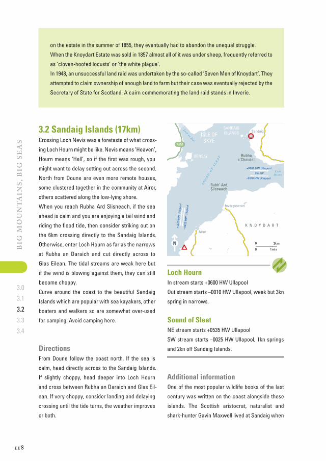
Loch na DalSandaig3.2 Sandaig Islands (17km)
Crossing Loch Nevis was a foretaste of what cross-
ing Loch Hourn might be like. Nevis means ‘Heaven’,
Hourn means ‘Hell’, so if the first was rough, you
might want to delay setting out across the second.
North from Doune are even more remote houses,
some clustered together in the community at Airor,
others scattered along the low-lying shore.
When you reach Rubha Ard Slisneach, if the sea
ahead is calm and you are enjoying a tail wind and
riding the flood tide, then consider striking out on
the 6km crossing directly to the Sandaig Islands.
Otherwise, enter Loch Hourn as far as the narrows
at Rubha an Daraich and cut directly across to
Glas Eilean. The tidal streams are weak here but
if the wind is blowing against them, they can still
become choppy.
Curve around the coast to the beautiful Sandaig
Islands which are popular with sea kayakers, other
boaters and walkers so are somewhat over-used
for camping. Avoid camping here.
DirectionsFrom Doune follow the coast north. If the sea is
calm, head directly across to the Sandaig Islands.
If slightly choppy, head deeper into Loch Hourn
and cross between Rubha an Daraich and Glas Eil-
ean. If very choppy, consider landing and delaying
crossing until the tide turns, the weather improves
or both.
Loch HournIn stream starts +0600 HW Ullapool
Out stream starts −0010 HW Ullapool, weak but 3kn
spring in narrows.
Sound of Sleat NE stream starts +0535 HW Ullapool
SW stream starts −0025 HW Ullapool, 1kn springs
and 2kn off Sandaig Islands.
on the estate in the summer of 1855, they eventually had to abandon the unequal struggle.
When the Knoydart Estate was sold in 1857 almost all of it was under sheep, frequently referred to
as ‘cloven-hoofed locusts’ or ‘the white plague’.
In 1948, an unsuccessful land raid was undertaken by the so-called ‘Seven Men of Knoydart’. They
attempted to claim ownership of enough land to farm but their case was eventually rejected by the
Secretary of State for Scotland. A cairn commemorating the land raid stands in Inverie.
Additional informationOne of the most popular wildlife books of the last
century was written on the coast alongside these
islands. The Scottish aristocrat, naturalist and
shark-hunter Gavin Maxwell lived at Sandaig when
3.2

1 19
Big
Mo
un
ta
ins,
Big
se
as
3.0
3.1
3.2
3.3
3.4
in 1960 he wrote Ring of Bright Water about how he
brought an otter back from Iraq and raised it here.
Sandaig was called ‘Camusfearna’ in the book,
which sold over a million copies and was made into
a movie starring Virginia McKenna in 1969.
Maxwell’s house at Sandaig burned down in 1968
and he moved to Eilean Ban, the island occupied
by a lighthouse under the Skye Bridge. Maxwell
planned to write a book about British wild mammals
and build a zoo on the island, but died from cancer
the following year. The Eilean Ban Trust (p 01599
530040, www.eileanban.org) runs the Bright Water
Visitor Centre at Kyleakin. Today there’s a white
house at Sandaig that is falling into disrepair,
and nearby a simple monument marks the site of
Camusfearna where Maxwell’s ashes are buried.
Why land ownership matters
Leading up to the Highland Clearances, most of the land was owned by absentee landlords who
rarely visited and left the running of the estates to their foremen, known as ‘factors’. These power-
ful men gradually took upon themselves most other public offices in their administrative districts
and acquired almost untouchable power. One man could be factor, banker and Justice of the
Peace, becoming virtually above the law.
Stories are told of cruel factors who would raise a crofter’s rent by sixpence on every occasion
he didn’t touch his cap as a sign of respect to them. Their assistants, so called ‘ground-officers’,
frequently came from crofting families, and were often despised more than the factor himself.
When the landlords decided sheep would be less trouble than people, the factors set about clear-
ing the people with whom they had grown up.
It’s easy to see why land ownership remains a powerful issue in Scotland to this day. The Land
Reform Bill was one of the first introduced to the Scottish Parliament and, as well as enshrining
a right of responsible access (see Overnight), it established rights for communities like Gigha to
buy their own land.
3.2
Gavin Maxwell’s house was near here on Sandaig Islands.

Scotland’s west coast is a truly world-
class sea kayaking destination. This 500km
trail, from the Isle of Gigha off the Kintyre
peninsula, to the Summer Isles near Ullapool,
is the best way to explore the highlights of this
magnificent coastline. It can be undertaken
in four holiday-sized sections or as one long,
glorious journey.
Here you will find all the information you
need to plan and make the most of your own
adventure, including:
• How to tackle tricky passages
• Essential tidal stream data
• Places to rest or shelter from storms
• Bad weather alternatives
• Where to find provisions
• How and when to shuttle vehicles
There are useful photographs and notes to
help identify wildlife, plus practical advice on
wild camping. There is no better way to travel
amongst these wild places than by kayak.
The national history of Scotland is inextricably
linked to the west coast, from the earliest
voyagers to Norsemen, the Lords of the Isles
to the Clearances. A historical thread, woven
through the book, tells Scotland’s story.
For those who travel the trail from the comfort
of an armchair, there is also the story of the
author’s own journey. Together you will travel
under big skies on imposing seas in the
company of seals, dolphins, eagles and gulls.
The ScoTTiSh Sea KayaK Trail awaiTS you.
9 7 8 1 9 0 6 0 9 5 1 7 8
ISBN 978-1-906095-17-810000
SCoTTISH SEA KAyAK TrAILSiMoN williS