Scott Cook’s Top-10 MUST-SEE South Island list · 94 West Coast - SOUTH D D1 Hokitika Gorge D2...
27
-
Upload
truongnhan -
Category
Documents
-
view
213 -
download
0
Transcript of Scott Cook’s Top-10 MUST-SEE South Island list · 94 West Coast - SOUTH D D1 Hokitika Gorge D2...

1
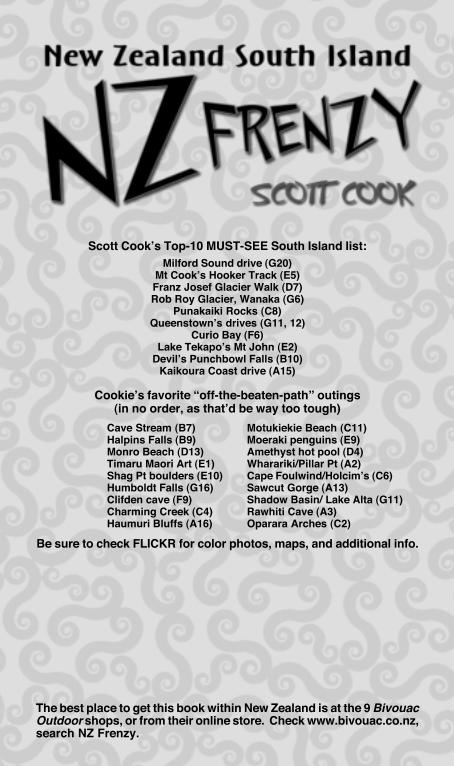
Scott Cook’s Top-10 MUST-SEE South Island list:Milford Sound drive (G20)
Mt Cook’s Hooker Track (E5)Franz Josef Glacier Walk (D7)Rob Roy Glacier, Wanaka (G6)
Punakaiki Rocks (C8)Queenstown’s drives (G11, 12)
Curio Bay (F6)Lake Tekapo’s Mt John (E2)
Devil’s Punchbowl Falls (B10)Kaikoura Coast drive (A15)
Cookie’s favorite “off-the-beaten-path” outings(in no order, as that’d be way too tough)
Be sure to check FLICKR for color photos, maps, and additional info.
The best place to get this book within New Zealand is at the 9 BivouacOutdoor shops, or from their online store. Check www.bivouac.co.nz,search NZ Frenzy.
Cave Stream (B7)Halpins Falls (B9)Monro Beach (D13)Timaru Maori Art (E1)Shag Pt boulders (E10)Humboldt Falls (G16)Clifden cave (F9)Charming Creek (C4)Haumuri Bluffs (A16)
Motukiekie Beach (C11)Moeraki penguins (E9)Amethyst hot pool (D4)Wharariki/Pillar Pt (A2)Cape Foulwind/Holcim’s (C6)Sawcut Gorge (A13)Shadow Basin/ Lake Alta (G11)Rawhiti Cave (A3)Oparara Arches (C2)
3
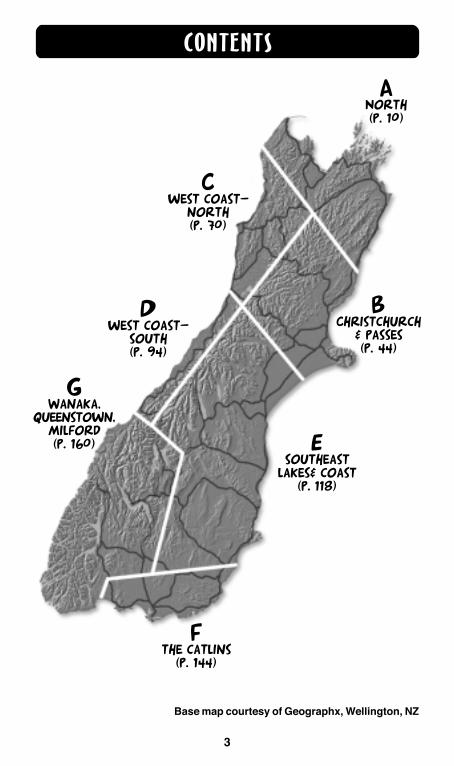
ANorth(p. 10)
BChristchurch
& passes(p. 44)
Cwest coast-
north(p. 70)
Dwest coast-
south(p. 94)
Esoutheast
lakes& coast(p. 118)
Fthe catlins
(p. 144)
GWanaka,
queenstown,milford(p. 160)
CONTENTS
Base map courtesy of Geographx, Wellington, NZ
9494
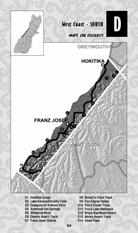
DWest Coast - SOUTH
D1 Hokitika Gorge
D2 Lake Kaniere/Dorothy Falls
D3 Cesspool of Arahura River
D4 Amethyst Hot Springs
D5 Whataroa River
D6 Okarito Beach Track
D7 Franz Josef Glacier
Maps on FlickR!!!
D8 Robert’s Point Track
D9 Fox Glacier Valley
D10 Fox’s Chalet Track
D11 Fox’s Lake Matheson
D12 Bruce Bay/Maori Beach
D13 Monro Beach Track
D14 Haast Pass
95
WEST COAST - SOUTH
95
D
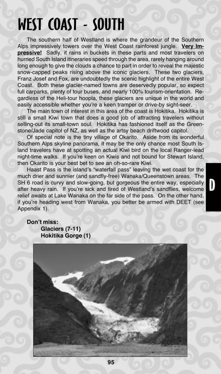
The southern half of Westland is where the grandeur of the SouthernAlps impressively towers over the West Coast rainforest jungle. Very Im-pressive! Sadly, it rains in buckets in these parts and most travelers onhurried South Island itineraries speed through the area, rarely hanging aroundlong enough to give the clouds a chance to part in order to reveal the majesticsnow-capped peaks rising above the iconic glaciers. These two glaciers,Franz Josef and Fox, are undoubtedly the scenic highlight of the entire WestCoast. Both these glacier-named towns are deservedly popular, so expectfull carparks, plenty of tour buses, and nearly 100% tourism-orientation. Re-gardless of the Heli-tour hoopla, these glaciers are unique in the world andeasily accessible whether you’re a keen tramper or drive-by sight-seer.
The main town of interest in this area of the coast is Hokitika. Hokitika isstill a small Kiwi town that does a good job of attracting travelers withoutselling-out its small-town soul. Hokitika has fashioned itself as the Green-stone/Jade capitol of NZ, as well as the artsy beach driftwood capitol.
Of special note is the tiny village of Okarito. Aside from its wonderfulSouthern Alps skyline panorama, it may be the only chance most South Is-land travelers have at spotting an actual Kiwi bird on the local Ranger-leadnight-time walks. If you’re keen on Kiwis and not bound for Stewart Island,then Okarito is your best bet to see an oh-so-rare Kiwi.
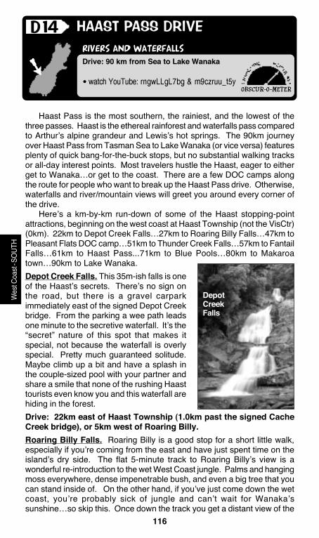
Haast Pass is the island’s “waterfall pass” leaving the wet coast for themuch drier and sunnier (and sandfly-free) Wanaka/Queenstown areas. TheSH 6 road is curvy and slow-going, but gorgeous the entire way, especiallyafter heavy rain. If you’re sick and tired of Westland’s sandflies, welcomerelief awaits at Lake Wanaka on the far side of the pass. On the other hand,if you’re heading west from Wanaka, you better be armed with DEET (seeAppendix 1).
Don’t miss:Glaciers (7-11)Hokitika Gorge (1)

96
• watch YouTube: wnzctLmL6ha
surreal blue water
HOKITIKA GORGE
DRIVING: A local map from the i-Site is a big help. In Hokitika onSH 6 turn at the signs for Kaniere Lake and Hokitika Gorge. Inabout 5km you’ll turn right to go to the Gorge, then follow signszig-zagging through the farm lands.
Walk: short, easy 7-minute stroll
D1(Hoe-ka-tick-a)
Visitors to Hokitika often combine a visit to Hokitika Gorge and LakeKaniere into a long 80km-driving outing. It’s probably best to see the Gorgefirst, and then plan to spend more time around the lake relaxing if theweather’s fine.
The Hokitika Gorge is a long drive—33km—from Hokitika, so thequestion is, “is the photo-op worth it?” Yes is the easy answer, especiallyif you are coming from the north. Even on a grey drizzly day the Gorge’scolors are impressive. There are many powder-blue rivers in the south ofthe South Island, but none more easily photographed than Hokitika’s Gorge.The water is an otherworldly milky opaque blue due to suspended glacier-ground “rock flour”. It’s the same eerie blue as Lakes Pukaki/Tekapo andrivers just to the south like Whataroa/Haast. What makes Hokitika Gorgeso special is that the water pools up and is penned-in by grey rocks for a300m stretch, all surrounded by verdant green bush and spanned by ascenic swingbridge. This makes the scene super-easy to photograph andappreciate. It’s almost impossible to take a bad photo of Hokitika Gorge,and when you get home, it’ll be the kind of photo that you’ll show others tomake them salivate over your NZ trip.
There’s not much to do at the Gorge than just look. From the carparkan easy track heads 7 minutes over to the swingbridge, and from there
you can scrambledown to the rocksand water for aquick icy splash.There are no otherwalks or anythingelse to explorenearby.
OBSCUR-O-METER
Wes
t Coa
st-S
OUTH
97
• various drive-up access points
swimming/boating lake with a waterfall
LAKE KANIERE/DOROTHY FALLS
DRIVING: It’s best to check a local map from the i-Site. FromHokitika the lake is 18km. Just north of town turn east on thesigned road and follow it to the lake.
If you are coming from Hokitika Gorge, turn in Kokatahi at signsfor the lake to get to the south end of shoreline road.
Walk: short walks
D2(kaan-ee-err)
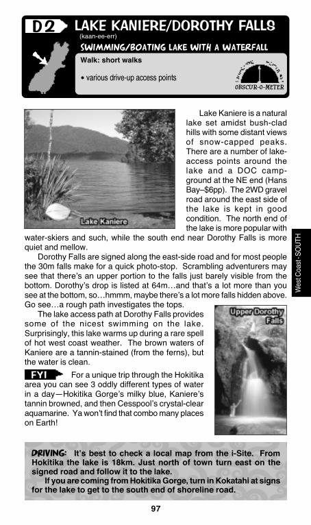
Lake Kaniere is a naturallake set amidst bush-cladhills with some distant viewsof snow-capped peaks.There are a number of lake-access points around thelake and a DOC camp-ground at the NE end (HansBay–$6pp). The 2WD gravelroad around the east side ofthe lake is kept in goodcondition. The north end ofthe lake is more popular with
water-skiers and such, while the south end near Dorothy Falls is morequiet and mellow.
Dorothy Falls are signed along the east-side road and for most peoplethe 30m falls make for a quick photo-stop. Scrambling adventurers maysee that there’s an upper portion to the falls just barely visible from thebottom. Dorothy’s drop is listed at 64m…and that’s a lot more than yousee at the bottom, so…hmmm, maybe there’s a lot more falls hidden above.Go see…a rough path investigates the tops.
The lake access path at Dorothy Falls providessome of the nicest swimming on the lake.Surprisingly, this lake warms up during a rare spellof hot west coast weather. The brown waters ofKaniere are a tannin-stained (from the ferns), butthe water is clean.
For a unique trip through the Hokitikaarea you can see 3 oddly different types of waterin a day—Hokitika Gorge’s milky blue, Kaniere’stannin browned, and then Cesspool’s crystal-clearaquamarine. Ya won’t find that combo many placeson Earth!
OBSCUR-O-METER
Wes
t Coa
st-S
OUTH
FYI

98
• bring: swimsuit, picnic, bug spray
REMOTE RIVER SWIMMING HOLE
THE CESSPOOL OF THE ARAHURA
Walk: easy/mod 25-minute one-way (2 km)
D3(ara-hoora)
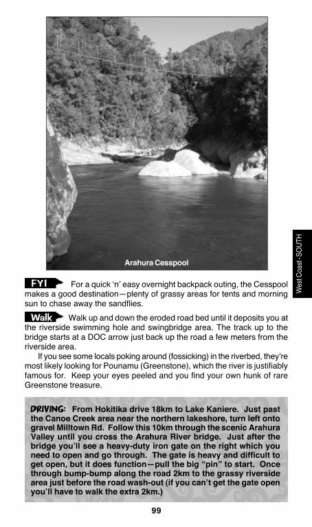
By definition a cesspool is “a sewage pit or morally disgusting place”.The Cesspool Gorge on the upper Arahura River in no way resemblesthat definition. Maybe, in some long-ago NZ time, this river gorge wastrashed by mining and such…but nowadays the river runs pure, thoughstuck with the uninviting name. The Cesspool Gorge, reached via a longdrive from Hokitika and then a short walk, is a fabulous swimming hole onthe crystal-blue Arahura. Making the scene even more interesting is anold-timey swingbridge spanning the gorge—one of the older ones withoutwood planking, just wiring…making for a real swinger! The pool is rimmedwith boulders to sun on/leap from and there are also sandy and grassyareas beside the river to picnic/sun/hang out. Of course, a sunny day surehelps to enjoy a swimming hole in Westland—if it’s grey out the Cesspoolwon’t be too scenic or inviting.
The Cesspool swingbridge is just the beginning of the multi-day Arahura/Styx Rivers tramp, so feel free to continue the track upriver for howeverlong you’d like before turning back, (or 4-5 days if you feel so inclined).Formerly the Cesspool area was the carpark for the multi-day tramp, butmost of the final 2km of the road has washed out and become a walkingtrack. Thus, the Cesspool is nowadays even more private because youhave to walk a bit on the old road to get to it instead of driving directly to it.
OBSCUR-O-METER
Wes
t Coa
st-S
OUTH
99
DRIVING: From Hokitika drive 18km to Lake Kaniere. Just pastthe Canoe Creek area near the northern lakeshore, turn left ontogravel Milltown Rd. Follow this 10km through the scenic ArahuraValley until you cross the Arahura River bridge. Just after thebridge you’ll see a heavy-duty iron gate on the right which youneed to open and go through. The gate is heavy and difficult toget open, but it does function—pull the big “pin” to start. Oncethrough bump-bump along the road 2km to the grassy riversidearea just before the road wash-out (if you can’t get the gate openyou’ll have to walk the extra 2km.)
Wes
t Coa
st-S
OUTH
For a quick ‘n’ easy overnight backpack outing, the Cesspoolmakes a good destination—plenty of grassy areas for tents and morningsun to chase away the sandflies.
Walk up and down the eroded road bed until it deposits you atthe riverside swimming hole and swingbridge area. The track up to thebridge starts at a DOC arrow just back up the road a few meters from theriverside area.
If you see some locals poking around (fossicking) in the riverbed, they’remost likely looking for Pounamu (Greenstone), which the river is justifiablyfamous for. Keep your eyes peeled and you find your own hunk of rareGreenstone treasure.
Walk
FYI
Arahura Cesspool
100
• bring: bug spray for sandflies, digging shovel
A SMALL SANDY HOT NATURAL POOL
AMETHYST HOT SPRINGS
Walk: easy 12-minute one-way (1.0 km)
D4
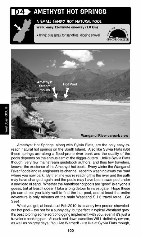
Amethyst Hot Springs, along with Sylvia Flats, are the only easy-to-reach natural hot springs on the South Island. Also like Sylvia Flats (B5)these springs are along a flood-prone river bank and the quality of thepools depends on the enthusiasm of the digger-outers. Unlike Sylvia Flatsthough, very few mainstream guidebook authors, and thus few travelers,know of the existence of the Amethyst hot pools. Every winter the WanganuiRiver floods and re-engineers its channel, recently washing away the roadwhere you now park. By the time you’re reading this the river and the pathmay have changed again and the pools may have been swamped undera new load of sand. Whether the Amethyst hot pools are “good” is anyone’sguess, but at least it doesn’t take a long detour to investigate. Hope thesepix can direct you fairly well to find the hot pool, and at least the entireadventure is only minutes off the main Westland SH 6 travel route…GoSee!
What you get, at least as of Feb 2010, is a sandy two-person shoveled-out hot pool—too hot for a sunny day, but perfect in typical Westland grey.It’s best to bring some sort of digging implement with you, even if it’s just atraveler’s cooking pan. At dusk and dawn sandflies WILL definitely swarm,as well as on grey days. You Are Warned! Just like at Sylvia Flats though,
OBSCUR-O-METER
Wes
t Coa
st-S
OUTH
Wanganui River carpark view
AmethystStreammouth
Hot Pool

101
DRIVING: On SH 6, 5km north of Harihari, on the north side of theWanganui River bridge, turn upstream on the unsigned road andgo just 1km until the road ends at the wash out (with the privategate on the left.)
Coming from the north the Wanganui Bridge is about 11kmsouth of Lake Ianthe.
Wes
t Coa
st-S
OUTH
the sandflies go to bed at dark leaving just you, your mermaid, a box ofwine, and the Southern Cross rising over the mountains. If you visit byday, even if the springs are too hot, the huge sandy riverbed “beach”surrounding the pools makes a great place to play Frisbee, skip stones,and lessen your tan lines.
The Amethyst hot pool area is also perfect short overnight tent outing—just set up camp on the huge sandbar (of course, not when rain pours andflood threatens). There’s heaps of available driftwood for a nice night ofhot-pool ‘n’ bonfire riversong serenity.
Pssst, nobody tell Lonely Planet about this spot! From the road-end “Wanganui Valley” sign head straight for
the river then follow the user-path along the top of the bluff where the roadwas washed away. The springs are just 1km ahead along the sandy leftbank of the river. Go through some bush and then onto the “closed” roadfor a few hundred meters to the Amethyst Stream bridge. Cross the bridgeand go exactly 200m and look for the path on the right leading quicklydown to the Wanganui Riverbed. At the riverbed the springs are to theright (downstream), halfway to mouth of the Amethyst Stream, tucked nextto the bush line. (As you emerge from the path to the riverbed, make sureto take a look back so you can find the path on the way out—it’s easy tomisplace.)
Walk
102
• discount glacier flights
• watch YouTube: qbb5q9b2kLa
a river of car-stopping blue
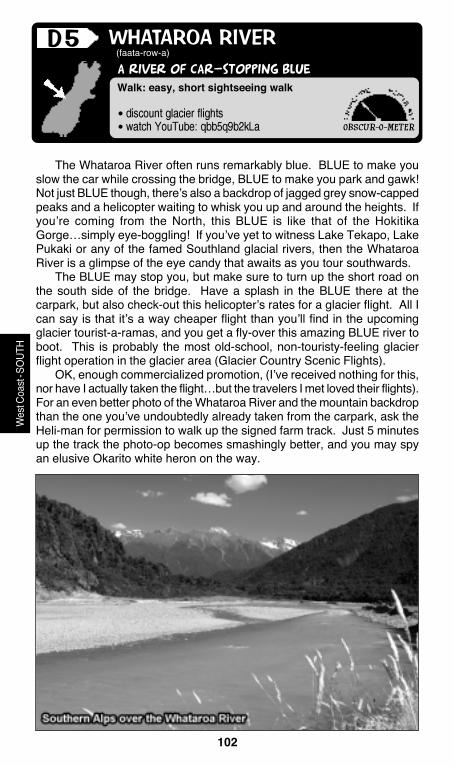
WHATAROA RIVER
Walk: easy, short sightseeing walk
D5(faata-row-a)
The Whataroa River often runs remarkably blue. BLUE to make youslow the car while crossing the bridge, BLUE to make you park and gawk!Not just BLUE though, there’s also a backdrop of jagged grey snow-cappedpeaks and a helicopter waiting to whisk you up and around the heights. Ifyou’re coming from the North, this BLUE is like that of the HokitikaGorge…simply eye-boggling! If you’ve yet to witness Lake Tekapo, LakePukaki or any of the famed Southland glacial rivers, then the WhataroaRiver is a glimpse of the eye candy that awaits as you tour southwards.
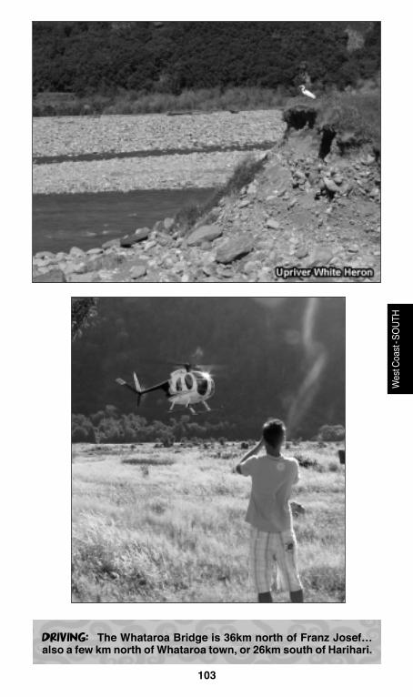
The BLUE may stop you, but make sure to turn up the short road onthe south side of the bridge. Have a splash in the BLUE there at thecarpark, but also check-out this helicopter’s rates for a glacier flight. All Ican say is that it’s a way cheaper flight than you’ll find in the upcomingglacier tourist-a-ramas, and you get a fly-over this amazing BLUE river toboot. This is probably the most old-school, non-touristy-feeling glacierflight operation in the glacier area (Glacier Country Scenic Flights).
OK, enough commercialized promotion, (I’ve received nothing for this,nor have I actually taken the flight…but the travelers I met loved their flights).For an even better photo of the Whataroa River and the mountain backdropthan the one you’ve undoubtedly already taken from the carpark, ask theHeli-man for permission to walk up the signed farm track. Just 5 minutesup the track the photo-op becomes smashingly better, and you may spyan elusive Okarito white heron on the way.
OBSCUR-O-METER
Wes
t Coa
st-S
OUTH
103
DRIVING: The Whataroa Bridge is 36km north of Franz Josef…also a few km north of Whataroa town, or 26km south of Harihari.
Wes
t Coa
st-S
OUTH
104
• watch Meet the Locals: “Rarest Kiwi”
• bring: tide chart, Kiwi bird curiosity
view-packed beach/bluffs loop walk
OKARITO BEACH LOOP ROUTE
Walk: moderate 2-hour beach and bluffsloop walk (7km round-trip)
D6(oka-reeto)
Okarito often gets tourism publicity for its commercial Okarito Lagoontours and kayak rentals as well as the night-time Kiwi bird tours where youcan actually see a live Kiwi bird in the wild! These one-of-a-kind night-time tours, led by a dedicated local Kiwi-conservationist, cost about $60pp,which is way cheaper than a trip to Stewart Island. (The North Island hastwo such opportunities to see a Kiwi in the wild…at Trounson Park andAroha Island, both in my North guidebook.)
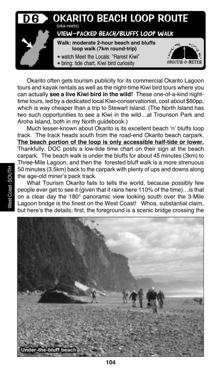
Much lesser-known about Okarito is its excellent beach ‘n’ bluffs looptrack. The track heads south from the road-end Okarito beach carpark.The beach portion of the loop is only accessible half-tide or lower.Thankfully, DOC posts a low-tide time chart on their sign at the beachcarpark. The beach walk is under the bluffs for about 45 minutes (3km) toThree-Mile Lagoon, and then the forested bluff walk is a more strenuous50 minutes (3.5km) back to the carpark with plenty of ups and downs alongthe age-old miner’s pack track.
What Tourism Okarito fails to tells the world, because possibly fewpeople ever get to see it (given that it rains here 110% of the time)…is thaton a clear day the 180° panoramic view looking south over the 3-MileLagoon bridge is the finest on the West Coast! Whoa, substantial claim,but here’s the details; first, the foreground is a scenic bridge crossing the
OBSCUR-O-METER
Wes
t Coa
st-S
OUTH
105
DRIVING: Okarito is signed from SH 6 between Whataroa andFranz Josef, then 10km down the paved road.
Wes
t Coa
st-S
OUTH
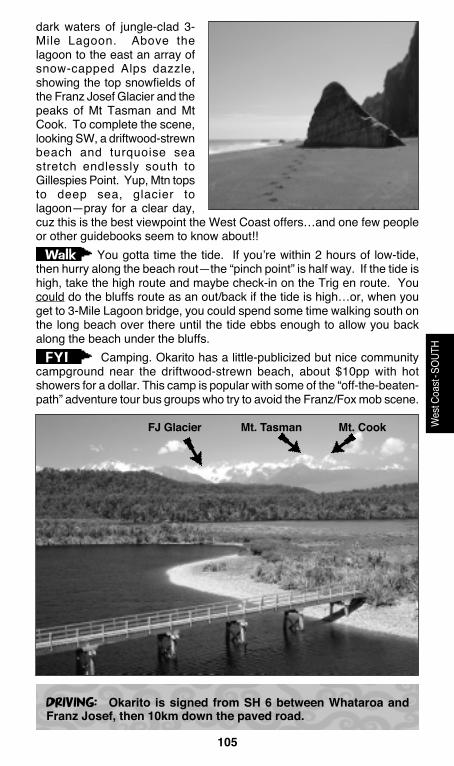
dark waters of jungle-clad 3-Mile Lagoon. Above thelagoon to the east an array ofsnow-capped Alps dazzle,showing the top snowfields ofthe Franz Josef Glacier and thepeaks of Mt Tasman and MtCook. To complete the scene,looking SW, a driftwood-strewnbeach and turquoise seastretch endlessly south toGillespies Point. Yup, Mtn topsto deep sea, glacier tolagoon—pray for a clear day,cuz this is the best viewpoint the West Coast offers…and one few peopleor other guidebooks seem to know about!!
You gotta time the tide. If you’re within 2 hours of low-tide,then hurry along the beach rout—the “pinch point” is half way. If the tide ishigh, take the high route and maybe check-in on the Trig en route. Youcould do the bluffs route as an out/back if the tide is high…or, when youget to 3-Mile Lagoon bridge, you could spend some time walking south onthe long beach over there until the tide ebbs enough to allow you backalong the beach under the bluffs.
Camping. Okarito has a little-publicized but nice communitycampground near the driftwood-strewn beach, about $10pp with hotshowers for a dollar. This camp is popular with some of the “off-the-beaten-path” adventure tour bus groups who try to avoid the Franz/Fox mob scene.
Walk
FYI
FJ Glacier Mt. Tasman Mt. Cook

106
• watch YouTube: 06y7h8qdyyu & h9xqLqL1yfu
• bring: swimsuit, sandals
THE BETTER GLACIER VALLEY WALK
FRANZ JOSEF GLACIER VALLEY TRACK
Walk: easy 30 minute (2.5 km) one-way
D7
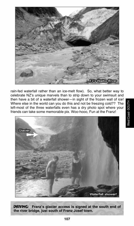
The Franz Josef Glacier Valley walk is the more interesting of the twoglacier valley walks, and it seems less crowded since tourists are spreadout over a longer distance than at Fox Glacier. It takes an easy 30 minutesfrom the carpark to reach the roped-off end of the track some 200m beforethe glacier’s snout. Along the way there are a bunch of waterfalls in sidecanyons and a very photogenic triple falls directly on the track. Red-blossomed Southern Rata trees adorn the towering canyon walls in thesummertime. Sheer jagged walls tower overhead and you get a goodlook up the face of FJ’s canyon-filling ice field as you walk towards it. Atthe track’s end near the crumbling nose of the glacier you’ll get a goodlook at the cave from whence pours the icy Waiho River. Ropes and signsprevent people from attempting to get closer to the wall of ice (peoplehave died getting too close and having ice chunks “knock ‘em cold”). Oftenyou’ll also see parties of guided glacier-walkers making their way downthe hyper-steep front face of the gravel-covered portion of the snout.
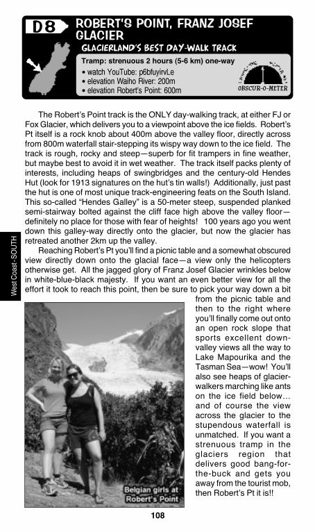
If you’re the type for wacky off-the-beaten-path ideas, then wear abathing suit under your regular clothes for this track. The scenic triplewaterfall that tumbles down the canyon wall about half-way to the glacier,surprisingly, isn’t ice cold—it’s the “temperate” part of this wondrously uniqueglacier/rainforest combo that makes this area so special in the world (it’s a
OBSCUR-O-METER
Wes
t Coa
st-S
OUTH
107
DRIVING: Franz’s glacier access is signed at the south end ofthe river bridge, just south of Franz Josef town.
Wes
t Coa
st-S
OUTH
rain-fed waterfall rather than an ice-melt flow). So, what better way tocelebrate NZ’s unique marvels than to strip down to your swimsuit andthen have a bit of a waterfall shower—in sight of the frozen wall of ice!Where else in the world can you do this and not be freezing cold?? Theleft-most of the three waterfalls even has a dry photo spot where yourfriends can take some memorable pix. Woo-hooo, Fun at the Franz!
108
• watch YouTube: p6bfuyirvLe
• elevation Waiho River: 200m
• elevation Robert’s Point: 600m
GLACIERLAND’S BEST DAY-WALK TRACK
ROBERT’S POINT, FRANZ JOSEF
GLACIER
Tramp: strenuous 2 hours (5-6 km) one-way
D8
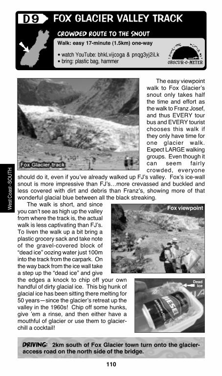
The Robert’s Point track is the ONLY day-walking track, at either FJ orFox Glacier, which delivers you to a viewpoint above the ice fields. Robert’sPt itself is a rock knob about 400m above the valley floor, directly acrossfrom 800m waterfall stair-stepping its wispy way down to the ice field. Thetrack is rough, rocky and steep—superb for fit trampers in fine weather,but maybe best to avoid it in wet weather. The track itself packs plenty ofinterests, including heaps of swingbridges and the century-old HendesHut (look for 1913 signatures on the hut’s tin walls!) Additionally, just pastthe hut is one of most unique track-engineering feats on the South Island.This so-called “Hendes Galley” is a 50-meter steep, suspended plankedsemi-stairway bolted against the cliff face high above the valley floor—definitely no place for those with fear of heights! 100 years ago you wentdown this galley-way directly onto the glacier, but now the glacier hasretreated another 2km up the valley.
Reaching Robert’s Pt you’ll find a picnic table and a somewhat obscuredview directly down onto the glacial face—a view only the helicoptersotherwise get. All the jagged glory of Franz Josef Glacier wrinkles belowin white-blue-black majesty. If you want an even better view for all theeffort it took to reach this point, then be sure to pick your way down a bit
from the picnic table andthen to the right whereyou’ll finally come out ontoan open rock slope thatsports excellent down-valley views all the way toLake Mapourika and theTasman Sea—wow! You’llalso see heaps of glacier-walkers marching like antson the ice field below…and of course the viewacross the glacier to thestupendous waterfall isunmatched. If you want astrenuous tramp in theglaciers region thatdelivers good bang-for-the-buck and gets youaway from the tourist mob,then Robert’s Pt it is!!
OBSCUR-O-METER
Wes
t Coa
st-S
OUTH

109
DRIVING: Head up the FJ Glacier Valley road. You can begin atthe road-end carpark, but doing so adds an extra dullish 1.0km.The better start point is 1km before the glacier road-end at theLake Wombat trailhead. Across from the Wombat track you’ll seea track that quickly leads to the DOC sign announcing the track.
Wes
t Coa
st-S
OUTH
Tramp Expect astrenuous true trampingtrack with lots of wetroots, rocks, and swing-bridges. The track ismarked the entire waywith no junctions oroptions. It’s 10 min to thefirst bridge, then 20 moredrops you back to thevalley floor via steps.Now the real climbingbegins…20 minutes toHendes Hut, then a non-stop 50-minute ascent tothe Point. All along theway there are plenty ofstream-crossing splashspots.
FJ ice-walkers
110
• watch YouTube: bhkLvijcoga & pnqg3yj2iLk
• bring: plastic bag, hammer
CROWDED ROUTE TO THE SNOUT
FOX GLACIER VALLEY TRACK
DRIVING: 2km south of Fox Glacier town turn onto the glacier-access road on the north side of the bridge.
Walk: easy 17-minute (1.5km) one-way
D9
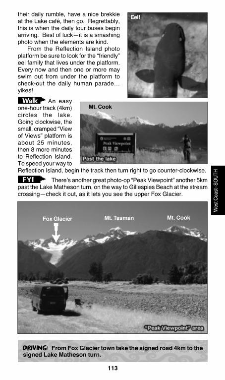
The easy viewpointwalk to Fox Glacier’ssnout only takes halfthe time and effort asthe walk to Franz Josef,and thus EVERY tourbus and EVERY touristchooses this walk ifthey only have time forone glacier walk.Expect LARGE walkinggroups. Even though itcan seem fairlycrowded, everyone
should do it, even if you’ve already walked up FJ’s valley. Fox’s ice-wallsnout is more impressive than FJ’s…more crevassed and buckled andless covered with dirt and debris than Franz’s, showing more of thatwonderful glacial blue between all the black streaking.
The walk is short, and sinceyou can’t see as high up the valleyfrom where the track is, the actualwalk is less captivating than FJ’s.To liven the walk up a bit bring aplastic grocery sack and take noteof the gravel-covered block of“dead ice” oozing water just 100minto the track from the carpark. Onthe way back from the ice wall takea step up the “dead ice” and givethe edges a knock to chip off your ownhandful of dirty glacial ice. This big hunk ofglacial ice has been sitting there melting for50 years—since the glacier’s retreat up thevalley in the 1960s! Chip off some hunks,give ’em a rinse, and then either have amouthful of glacier or use them to glacier-chill a cocktail!
OBSCUR-O-METER
Wes
t Coa
st-S
OUTH
DeadIce
Fox viewpoint

111
• elevation carpark: 260m
• elevation viewpoint: 440m
AN ELEVATED VIEW OF FOX GLACIER’S UPPERREACHES
FOX GLACIER’S CHALET TRACK
DRIVING: South of Fox Glacier town, turn onto the glacier accessroad on the south side of the Fox River bridge, then 3km to theroad-end carpark.
Walk: moderate 30-minute (2km) one-way
D10
The Chalet track is a moderatelyuphill track ending at a view platformoverlooking Fox Glacier’s blue-blackicy snout. This is an impressiveglacial view for a relatively paltryeffort…and better yet, no tour busesbring their hordes up here. TheChalet track is fine-weather-only,asdrizzle makes it slippery and lots ofrain makes a stream-crossingimpassable. On a sunny day, thistrack, more than any other FJ/FoxGlacier track, highlights the uniquenature of these NZ glaciers—alpineice mixed with rainforest. On the wayto the historic “chalet” view you’ll thinkyou’re in the tropics as tree fernshung with moss line the track,epiphytic plants hang from tree limbs, and the summertime red blossomsof the Southern Rata trees are reminiscent of tropical Hibiscus.
Arriving at the track’s-end viewpoint,you’ll find one of the few locations in theworld where you can frame both fernsand glacier in the same photo—neat!Looking closely at the upper glacieryou’ll undoubtedly see the ant-like ice-walkers, and below to the left is the FoxGlacier valley-walk viewpoint. Surround-ing the viewpoint the Southern Alpsridgelines tower 1,200 meters above you!
The better view of thecomplete top-to-bottom Fox Glacier isfrom the roadside signed viewpoint, notthe steep 15-min track to thedisappointingly overgrown “Fox Glacierviewpoint”.
OBSCUR-O-METER
Wes
t Coa
st-S
OUTH
FYI
Fox roadsidephoto-op
Note upper glacier

112
• watch YouTube: 65Lvfp5bo-u
FAMOUS ALPS-REFLECTION PHOTO-OP
FOX GLACIER’S LAKE MATHESON
Walk: easy one-hour (4km) loop walk
D11
The early morning reflection of Mts Tasman and Cook in the still tannin-stained waters of Lake Matheson is as perfect as a reflection photo gets.Wonderfully, DOC has extended the “Reflection Island” viewpoint stepsright down to the lakeside point where the reflection shines best. Expectplenty of tourist company on this lakeshore loop because every tour busstops here and the easy walk over to the lake makes the outing all-agesfriendly. The track makes a loop around the entire lake with stops at twoviewpoint platforms (Reflection Island is the better one.)
For keen photographers, neither dawn nor sunset is best for lightingthe reflection scene. Dawn is WAY too back-lit and near dusk the entireFox Glacier canyon is in deep shadow. In the afternoon, when the lightmay be best, that’s when the glacier breeze stirs up the lake. Thus, thetime that the photo-pros go to get their “shot” would be mid-morning on acalm sunny day—about 8:30-9am (of course on a clear calm sunnyday…Ha!) This lets the rising sun creep high enough to light some of theforeground ridges, but before the thermal winds begin to blow. As aphotographer, don’t bother to sleep in the carpark and hustle out at dawn,because dawn only disappoints. Wait for the tourist airplanes to begin
OBSCUR-O-METER
Wes
t Coa
st-S
OUTH
Tasman Cook
Reflection Island view
113
DRIVING: From Fox Glacier town take the signed road 4km to thesigned Lake Matheson turn.
Wes
t Coa
st-S
OUTH
Walk
FYI
their daily rumble, have a nice brekkieat the Lake café, then go. Regrettably,this is when the daily tour buses beginarriving. Best of luck—it is a smashingphoto when the elements are kind.
From the Reflection Island photoplatform be sure to look for the “friendly”eel family that lives under the platform.Every now and then one or more mayswim out from under the platform tocheck-out the daily human parade…yikes!
An easyone-hour track (4km)circles the lake.Going clockwise, thesmall, cramped “Viewof Views” platform isabout 25 minutes,then 8 more minutesto Reflection Island.To speed your way toReflection Island, begin the track then turn right to go counter-clockwise.
There’s another great photo-op “Peak Viewpoint” another 5kmpast the Lake Matheson turn, on the way to Gillespies Beach at the streamcrossing—check it out, as it lets you see the upper Fox Glacier.
Eel!
Mt. Cook
Fox Glacier Mt. Tasman Mt. Cook

114
• watch YouTube: _avzcupe–re
HELLO/GOODBYE WEST COAST!!
BRUCE BAY/MAORI BEACH
Walk: Roadside beach sculptures
D12
This section of the West Coasthighway runs right along the beachfor a couple km, and if you’retraveling southwards, this is the firsttime the highway has hugged theshoreline since Punakaiki. For somereason travelers stop along thissection of coastline every year tostack rocks into some peculiarbalancey combinations. Who knowswhy?? Because it’s the final glimpseof the Tasman for southboundtravelers? Because it’s the firstglimpse for northbounders? Call itwhimsy, joy, love……whatever it is,people stop and create travelertributes to NZ every year. Alwaysthe same, but always different.
Where’s yours?
OBSCUR-O-METER
Wes
t Coa
st-S
OUTH
DRIVING: 45km south of Fox Glacier, or 25km north of LakeParinga.
115
• watch YouTube: 6s2y_ff4abo & 7fk3-oohckw
A BEACH WITH RARE PENGUINS
MONRO BEACH TRACK
DRIVING: The signed beach track is on SH 6 at the western endof Moeraki Lake, near the Lodge. It’s about 30km north of Haastor 19km south of Lake Paringa.
Walk: easy 30-minute (2.5km) one-wayto beach
D13
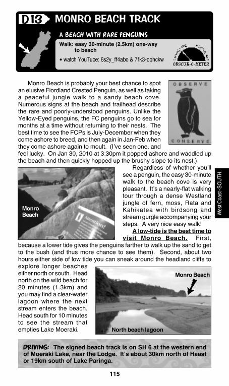
Monro Beach is probably your best chance to spotan elusive Fiordland Crested Penguin, as well as takinga peaceful jungle walk to a sandy beach cove.Numerous signs at the beach and trailhead describethe rare and poorly-understood penguins. Unlike theYellow-Eyed penguins, the FC penguins go to sea formonths at a time without returning to their nests. Thebest time to see the FCPs is July-December when theycome ashore to breed, and then again in Jan-Feb whenthey come ashore again to moult. (I’ve seen one, andfeel lucky. On Jan 30, 2010 at 3:30pm it popped ashore and waddled upthe beach and then quickly hopped up the brushy slope to its nest.)
Regardless of whether you’llsee a penguin, the easy 30-minutewalk to the beach cove is verypleasant. It’s a nearly-flat walkingtour through a dense Westlandjungle of fern, moss, Rata andKahikatea with birdsong andstream gurgle accompanying yoursteps. A very nice easy walk!
A low-tide is the best time tovisit Monro Beach. First,
because a lower tide gives the penguins farther to walk up the sand to getto the bush (and thus more chance to see them). Second, about twohours either side of low tide you can sneak around the headland cliffs toexplore longer beacheseither north or south. Headnorth on the wild beach for20 minutes (1.3km) andyou may find a clear-waterlagoon where the nextstream enters the beach.Head south for 10 minutesto see the stream thatempties Lake Moeraki.
OBSCUR-O-METER
Wes
t Coa
st-S
OUTH
MonroBeach
North beach lagoon
Monro Beach
116
• watch YouTube: rngwLLgL7bg & m9czruu_t5y
RIVERS AND WATERFALLS
HAAST PASS DRIVE
Drive: 90 km from Sea to Lake Wanaka
D14
Haast Pass is the most southern, the rainiest, and the lowest of thethree passes. Haast is the ethereal rainforest and waterfalls pass comparedto Arthur’s alpine grandeur and Lewis’s hot springs. The 90km journeyover Haast Pass from Tasman Sea to Lake Wanaka (or vice versa) featuresplenty of quick bang-for-the-buck stops, but no substantial walking tracksor all-day interest points. Most travelers hustle the Haast, eager to eitherget to Wanaka…or get to the coast. There are a few DOC camps alongthe route for people who want to break up the Haast Pass drive. Otherwise,waterfalls and river/mountain views will greet you around every corner ofthe drive.
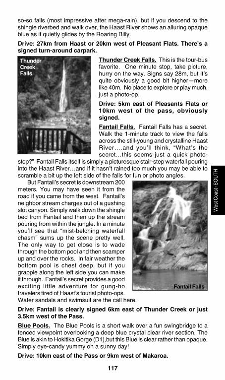
Here’s a km-by-km run-down of some of the Haast stopping-pointattractions, beginning on the west coast at Haast Township (not the VisCtr)(0km). 22km to Depot Creek Falls…27km to Roaring Billy Falls…47km toPleasant Flats DOC camp…51km to Thunder Creek Falls…57km to FantailFalls…61km to Haast Pass...71km to Blue Pools…80km to Makaroatown…90km to Lake Wanaka.Depot Creek Falls. This 35m-ish falls is oneof the Haast’s secrets. There’s no sign onthe road, but there is a gravel carparkimmediately east of the signed Depot Creekbridge. From the parking a wee path leadsone minute to the secretive waterfall. It’s the“secret” nature of this spot that makes itspecial, not because the waterfall is overlyspecial. Pretty much guaranteed solitude.Maybe climb up a bit and have a splash inthe couple-sized pool with your partner andshare a smile that none of the rushing Haasttourists even know you and this waterfall arehiding in the forest.Drive: 22km east of Haast Township (1.0km past the signed CacheCreek bridge), or 5km west of Roaring Billy.Roaring Billy Falls. Roaring Billy is a good stop for a short little walk,especially if you’re coming from the east and have just spent time on theisland’s dry side. The flat 5-minute track to Roaring Billy’s view is awonderful re-introduction to the wet West Coast jungle. Palms and hangingmoss everywhere, dense impenetrable bush, and even a big tree that youcan stand inside of. On the other hand, if you’ve just come down the wetcoast, you’re probably sick of jungle and can’t wait for Wanaka’ssunshine…so skip this. Once down the track you get a distant view of the
OBSCUR-O-METER
Wes
t Coa
st-S
OUTH
DepotCreekFalls
117
Wes
t Coa
st-S
OUTH
so-so falls (most impressive after mega-rain), but if you descend to theshingle riverbed and walk over, the Haast River shows an alluring opaqueblue as it quietly glides by the Roaring Billy.Drive: 27km from Haast or 20km west of Pleasant Flats. There’s asigned turn-around carpark.
Thunder Creek Falls. This is the tour-busfavorite. One minute stop, take picture,hurry on the way. Signs say 28m, but it’squite obviously a good bit higher—morelike 40m. No place to explore or play much,just a photo-op.Drive: 5km east of Pleasants Flats or10km west of the pass, obviouslysigned.Fantail Falls. Fantail Falls has a secret.Walk the 1-minute track to view the fallsacross the still-young and crystalline HaastRiver….and you’ll think, “What’s thesecret…this seems just a quick photo-
stop?” Fantail Falls itself is simply a picturesque stair-step waterfall pouringinto the Haast River…and if it hasn’t rained too much you may be able toscramble a bit up the left side of the falls for fun or photo angles.
But Fantail’s secret is downstream 200meters. You may have seen it from theroad if you came from the west. Fantail’sneighbor stream charges out of a gushingslot canyon. Simply walk down the shinglebed from Fantail and then up the streampouring from within the jungle. In a minuteyou’ll see that “mist-belching waterfallchasm” sums up the scene pretty well.The only way to get close is to wadethrough the bottom pool and then scamperup and over the rocks. In fair weather thebottom pool is chest deep, but if yougrapple along the left side you can makeit through. Fantail’s secret provides a goodexciting little adventure for gung-hotravelers tired of Haast’s tourist photo-ops.Water sandals and swimsuit are the call here.Drive: Fantail is clearly signed 6km east of Thunder Creek or just3.5km west of the Pass.Blue Pools. The Blue Pools is a short walk over a fun swingbridge to afenced viewpoint overlooking a deep blue crystal clear river section. TheBlue is akin to Hokitika Gorge (D1),but this Blue is clear rather than opaque.Simply eye-candy yummy on a sunny day!Drive: 10km east of the Pass or 9km west of Makaroa.
ThunderCreekFalls
Fantail Falls