Science Review Notes for Parents and Students
25
Science Review Notes for Parents and Students Grade 5 3rd Nine Weeks 2017-2018 Note: The Fifth Grade Standard of Learning test covers material taught in fourth and fifth grade.
Transcript of Science Review Notes for Parents and Students

Science
Review Notes for
Parents and Students
Grade 5 3rd Nine Weeks
2017-2018
Note: The Fifth Grade Standard of Learning test covers material taught in fourth and fifth grade.

Science Review Notes for Parents and Students
Grade 5 Science: Third Nine Weeks 2017-2018
This resource is intended to be a guide for parents and students to improve content
knowledge and understanding. The information below is detailed information about the
Standards of Learning taught during the 3rd grading period and comes from the Science
Standards of Learning Curriculum Framework, Grade 5 issued by the Virginia Department
of Education. The Curriculum Framework in its entirety can be found at the following
website.
http://www.doe.virginia.gov/testing/sol/frameworks/science_framewks/framework_science5.pdf
Standard 5.1
The student will demonstrate an understanding of scientific reasoning, logic, and the nature of science by planning and conducting investigations in which
a) items such as rocks, minerals, and organisms are identified using various classification keys;
b) estimates are made and accurate measurements of length, mass, volume, and temperature are made in metric units using proper tools;
c) estimates are made and accurate measurements of elapsed time are made using proper tools;
d) hypotheses are formed from testable questions;
e) independent and dependent variables are identified;
f) constants in an experimental situation are identified;
g) data are collected, recorded, analyzed, and communicated using proper graphical representations and metric measurements;
h) predictions are made using patterns from data collected, and simple graphical data are generated;
i) inferences are made and conclusions are drawn;
j) models are constructed to clarify explanations, demonstrate relationships, and solve needs; and

k) current applications are used to reinforce science concepts.
Overview
The skills in standard 5.1 are intended to define the “investigate” component and the understanding of the nature of science for all of the other fifth-grade standards. The intent of standard 5.1 is for students to continue to develop a range of inquiry skills, achieve proficiency with those skills, and develop and reinforce their understanding of the nature of science in the context of the concepts developed at the fifth-grade level. It is also intended that by developing these skills, students will achieve a greater understanding of scientific inquiry and the nature of science and will more fully grasp the content-related concepts.
Science assumes that the natural world is understandable. Scientific inquiry can provide explanations about nature. This expands students’ thinking from just knowledge of facts to understanding how facts are relevant to everyday life.
Systematic investigations require standard measures and consistent and reliable tools. Metric measures are a standard way to make measurements and are recognized around the world.
A classification key is an important tool used to help identify objects and organisms. It consists of a branching set of choices organized in levels, with most levels of the key having two choices. Each level provides more specific descriptors, eventually leading to identification.
A hypothesis is an educated guess/prediction about what will happen based on what you already know and what you have already learned from your research. It must be worded so that it is “testable.” The hypothesis can be written as an “If…, then….” statement, such as “If all light is blocked from a plant for two weeks, then the plant will die.”
An independent variable is the factor in an experiment that is altered by the experimenter. The independent variable is purposely changed or manipulated.
A dependent variable is the factor in an experiment that changes as a result of the manipulation of the independent variable.
The constants in an experiment are those things that are purposefully kept the same throughout the experiment.
A scientific prediction is a forecast about what may happen in some future situation. It is based on the application of factual information and principles and recognition of trends and patterns.
An inference is a tentative explanation based on background knowledge and available data.
A conclusion is a summary statement based on the results of an investigation. Scientific conclusions are based on verifiable observations (science is empirical).

Standard 5.6
The student will investigate and understand characteristics of the ocean environment. Key concepts include:
a) geological characteristics;
b) physical characteristics; and
c) ecological characteristics.
Overview
This standard extends the study of ecosystems to the ocean environment. It focuses on the major descriptive characteristics of oceans. Among the concepts are the geological characteristics of the ocean floor, the physical characteristics of ocean water, and the ecological characteristics of communities of marine organisms.
The Ocean
Oceans cover about 70 percent of the surface of the Earth.
Important features of the ocean floor near the continents are the continental shelf, the continental slope, and the continental rise. These areas are covered with thick layers of sediments (sand, mud, rocks).
The depth of the ocean varies. Ocean trenches are very deep, and the continental shelf is relatively shallow.
Ocean water is a complex mixture of gases (air) and dissolved solids (salts, especially sodium chloride). Marine organisms are dependent on dissolved gases for survival. The salinity of ocean water varies in some places depending on rates of evaporation and amount of runoff from nearby land.
The basic motions of ocean water are the waves, currents, and tides.
As the depth of ocean water increases, the temperature decreases, the pressure increases, and the amount of light decreases. These factors influence the type of life forms that are present at a given depth.
Plankton is tiny free-floating organisms that live in water. Plankton may be animal-like or plant-like. Animal-like plankton is called zooplankton. Plant-like plankton (phytoplankton) carries out most of the photosynthesis on Earth. Therefore, they provide much of Earth’s oxygen. Phytoplankton forms the base of the ocean food web. Plankton flourishes in areas where nutrient-rich water upwells from the deep.

The ocean floor is much like land it is just covered with water. You would see landforms such as mountains, valleys, hills and plains. The ocean floor has important features to include: the continental shelf, the continental slope, the continental rise, the abyssal plain and the ocean trenches.
Ocean Floor Feature Description
Continental Shelf It is at the beginning of the shore line and covered with thick layers of mud, sand and rocks.
Sunlight is able to shine on the continental shelf therefore; plant and animal life is can survive here.
Continental Slope It is at the end of the continental shelf and is also covered with thick layers of mud, sand and rocks.
Continental Rise The area that connects the continental slope to the ocean floor and is also covered with thick layers of mud, sand and rocks.
Ocean Trenches These are very deep and dark. Very little sunlight, animal or plant life is found in the trenches.
Abyssal Plain These are flat areas of the ocean floor that are covered with mud and sand. Seamounts are also located on these flat plains. Seamounts are formed by erupting volcanoes.
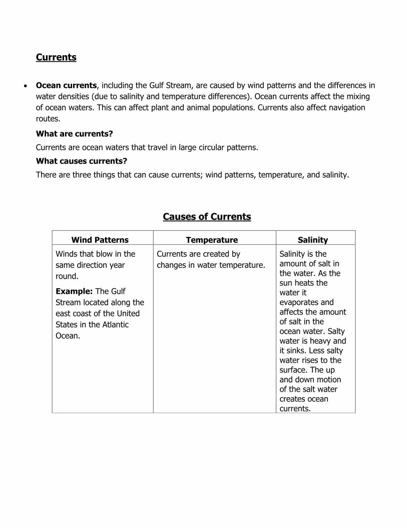
Currents
Ocean currents, including the Gulf Stream, are caused by wind patterns and the differences in
water densities (due to salinity and temperature differences). Ocean currents affect the mixing
of ocean waters. This can affect plant and animal populations. Currents also affect navigation
routes.
What are currents?
Currents are ocean waters that travel in large circular patterns.
What causes currents?
There are three things that can cause currents; wind patterns, temperature, and salinity.
Causes of Currents
Wind Patterns Temperature Salinity
Winds that blow in the
same direction year
round.
Example: The Gulf
Stream located along the
east coast of the United
States in the Atlantic
Ocean.
Currents are created by
changes in water temperature.
Salinity is the amount of salt in the water. As the sun heats the water it evaporates and affects the amount of salt in the ocean water. Salty water is heavy and it sinks. Less salty water rises to the surface. The up and down motion of the salt water creates ocean currents.

Virginia Standards of Learning Grade 5 Science Test
Released Practice Test Items
http://www.doe.virginia.gov/testing/sol/practice_items/index.shtml#science
Write the correct ocean feature in each box to properly label the ocean floor.
Answer: 1. Continental Shelf 2. Continental Slope 3. Continental Rise 4. Trench

What do the arrows on the map represent?
A Size of waves
B Water density
C Ocean currents
D Time between tides
Standard 5.7 The student will investigate and understand how Earth’s surface is constantly changing. Key concepts include:
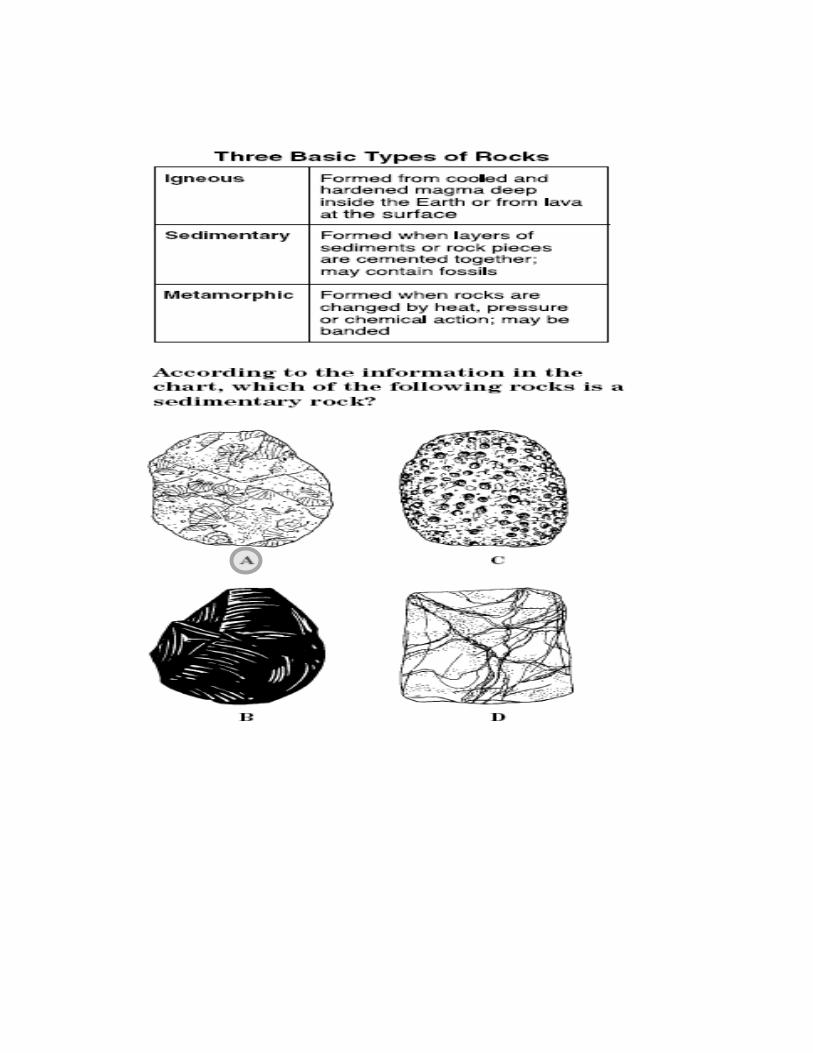
a) identification of rock types;
b) the rock cycle and how transformations between rocks occur;
c) Earth history and fossil evidence;
d) the basic structure of Earth’s interior;
e) changes in Earth’s crust due to plate tectonics;
f) weathering, erosion, and deposition; and
g) human impact.
Overview
This standard focuses on the constantly changing nature of Earth’s surface and builds on concepts learned in standards. Among the important ideas presented in this standard are the rock cycle, fossil evidence of change over time, energy from within Earth that drives tectonic plate movement, shifting tectonic plates that cause earthquakes and volcanoes, weathering and erosion, and human interaction with the Earth’s surface.
The Rock Cycle
Rocks move and change over time due to heat and pressure within Earth and due to weathering, erosion, and deposition at the surface. These and other processes constantly change rock from one type to another.
Depending on how rocks are formed, they are classified as sedimentary (layers of sediment cemented together), igneous (melted and cooled, e.g., lava and magma), and metamorphic (changed by heat and pressure).
Rocks have properties that can be observed, tested, and described. Composition, grain size and textural features, color, and the presence of fossils help with identification.

Rocks and other materials on Earth’s surface are constantly being broken down both chemically and physically. The products of weathering include clay, sand, rock fragments, and soluble substances.
Materials can be moved by water and wind (eroded) and deposited in new locations as sediment (deposition).
Weathering is the breaking down of rocks.
Erosion is the carrying away of the rocks and materials by either wind or water.
Deposition is the depositing of rocks and materials in a new location as sediment.

Note:
Scientific evidence indicates the Earth is very ancient — approximately 4.6 billion years old. The age of many rocks can be determined very reliably.
Fossils provide information about life and conditions of the past.
The Rock Cycle Never Ends!
The Earth’s Layers
Scientific evidence indicates that the Earth is composed of four concentric layers — crust, mantle, inner core, and outer core — each with its own distinct characteristics. The outer two layers are composed primarily of rocky material. The innermost layers are composed mostly of iron and nickel. Pressure and temperature increase with depth beneath the surface.
Model of the Earth
Inner Core – composed mostly of
iron and nickel
Outer Core - composed mostly of iron and nickel
Mantle -composed primarily of rocky material.
Crust- The thinnest layer and composed primarily of rocky material.

Earth’s thermal energy causes movement of material within Earth. Large continent-size blocks
(plates) move slowly about Earth’s surface, driven by that thermal energy.
Most earthquakes and volcanoes are located at the boundaries of the plates (faults). Plates can
move together (convergent boundaries), apart (divergent boundaries), or slip past each
other horizontally (transform boundaries, also called strike-slip or sliding boundaries).
Geological features in the oceans (including trenches and mid-ocean ridges) and on the continents
(mountain ranges, including the Appalachian Mountains) are caused by current and past plate
movements.
Convergent Boundaries
Divergent Boundaries
Sliding, Strike-slip or Transform Boundaries
When plates push
together convergent
boundaries are formed.
They cause mountain
ranges on land. Such as the
Appalachian Mountains of
Virginia.
Convergent boundaries
form trenches under water.
They force plates downward
instead of upward below
water.
A divergent boundary is
formed when plates
move apart. Most form
on ocean floors by
magma rising up
between two plates.
They form volcanoes
and mountain ranges
under water.
These boundaries are
formed when plates slide
past each other.
These boundaries cause
earthquakes.

Human Impact on the Earth
Humans have varying degrees of impact on Earth’s surface through their everyday activities. With
careful planning, the impact on the land can be controlled.
What are some ways humans’ negative impact on the land can be controlled?
Think for a moment about what it would be like without paper, napkins, toilet paper? Where do
these things come from?
o They originate from trees. Companies must begin by farming large areas of trees. In order
to control the impact on the land, it is necessary to plant and replenish what is used
What can you do? Can you think of one way humans can have a positive impact on the
land?
Released Practice Items
Virginia Standards of Learning Grade 5 Science Test
Follow this link to find practice test:
http://www.doe.virginia.gov/testing/sol/practice_items/science/guides/gr_5_science.pdf

mass 5.1
Mass is the amount of matter in an object.
volume
5.1
Volume is the amount of space occupied by an object.
milliliter
5.1
Milliliter is a unit of liquid volume.
length
5.1
Length is the distance between two points.
millimeter
5.1
A millimeter is one-thousandth of a meter and 1/10 of a centimeter.
centimeter
5.1
A centimeter is a unit of length in the metric system; one-hundredth of a meter, or about two-fifths of an inch, about the width of a large clip.
meter
5.1
A meter is a unit for measuring metric length; is equal to about 1 yard.
kilometer
5.1
A kilometer is a metric unit and is a little smaller than 1 mile.

temperature 5.1
Temperature is a measure of how hot or cold something is.
degrees
5.1
Degrees are units of temperature.
Celsius
5.1
Celsius is a metric unit for temperature.
estimation
5.1
Estimation is a method of making an educated guess at a measurement.
prediction 5.1
A prediction is a forecast about what may happen in some future situations. It is based on the application of factual information and principles and recognition of trends and patterns.
variable
5.1
A variable is something in an experiment that can change or stay the same.
independent variable 5.1
An independent variable is a variable that is changed in an experiment.
dependent variable
5.1
A dependent variable is a variable that is observed and that changes in the response to the independent variable.
inference
5.1
An inference is a logical conclusion based on observations.
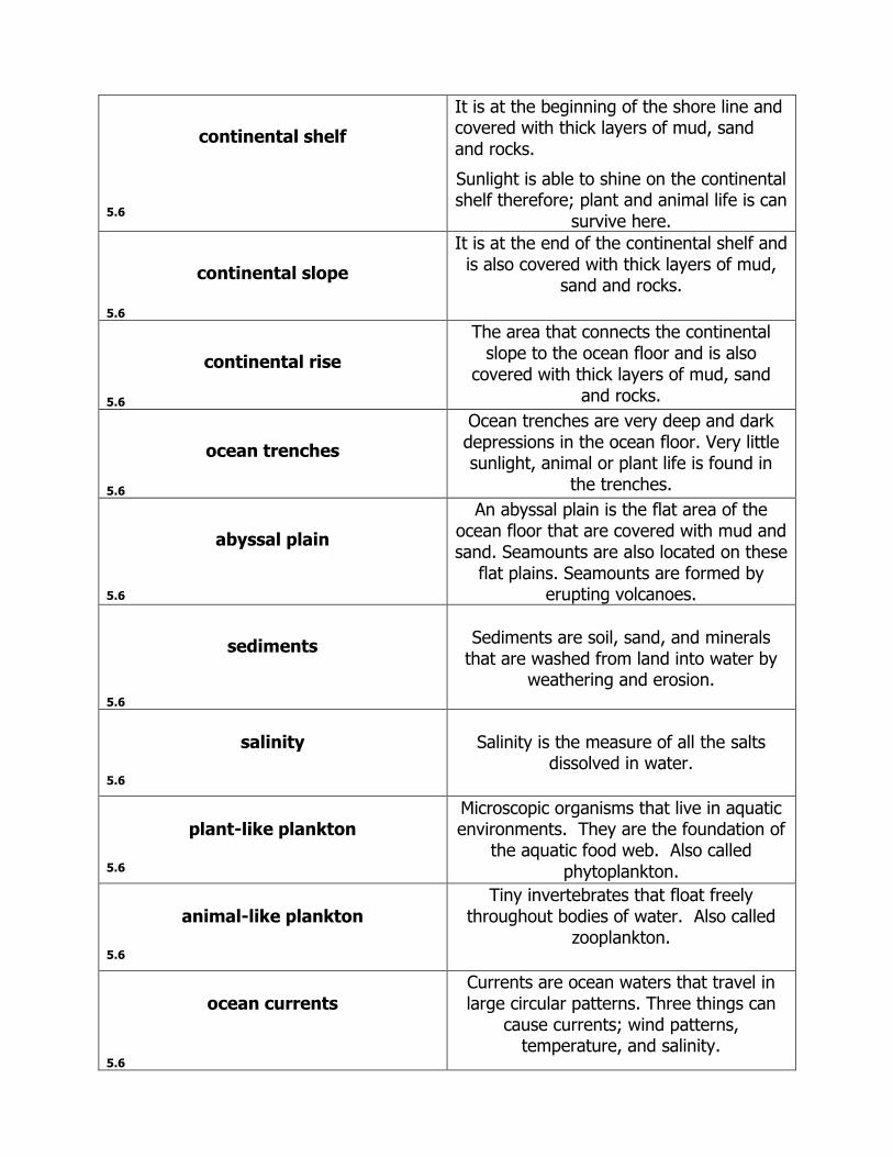
continental shelf
5.6
It is at the beginning of the shore line and covered with thick layers of mud, sand and rocks.
Sunlight is able to shine on the continental shelf therefore; plant and animal life is can
survive here.
continental slope
5.6
It is at the end of the continental shelf and is also covered with thick layers of mud,
sand and rocks.
continental rise
5.6
The area that connects the continental slope to the ocean floor and is also
covered with thick layers of mud, sand and rocks.
ocean trenches
5.6
Ocean trenches are very deep and dark depressions in the ocean floor. Very little sunlight, animal or plant life is found in
the trenches.
abyssal plain
5.6
An abyssal plain is the flat area of the ocean floor that are covered with mud and sand. Seamounts are also located on these
flat plains. Seamounts are formed by erupting volcanoes.
sediments
5.6
Sediments are soil, sand, and minerals
that are washed from land into water by weathering and erosion.
salinity
5.6
Salinity is the measure of all the salts
dissolved in water.
plant-like plankton
5.6
Microscopic organisms that live in aquatic environments. They are the foundation of
the aquatic food web. Also called phytoplankton.
animal-like plankton
5.6
Tiny invertebrates that float freely throughout bodies of water. Also called
zooplankton.
ocean currents
5.6
Currents are ocean waters that travel in large circular patterns. Three things can
cause currents; wind patterns, temperature, and salinity.

weathering 5.7
The breaking down of rocks.
Erosion
5.7
The carrying away of the rocks and materials by both wind and/or water.
deposition
5.7
The depositing of rocks and materials in a new location as sediment.
sedimentary rocks 5.7
Rocks that have layers of sediments cemented together.
igneous rocks 5.7
Rocks that have melted and cooled. Ex. Lava and magma
metamorphic rocks 5.7
Rocks that were changed by heat and pressure.
fossils 5.7
Items that provide information about life and conditions of the past.
Earth’s crust 5.7
The thinnest layer of Earth composed primarily of rocky material.
mantle 5.7
One of the outermost layers of Earth composed primarily of rocky material.
inner core 5.7
The innermost layer of Earth composed of iron and nickel.
outer core 5.7
One of the innermost layers of Earth composed of iron and nickel.
thermal energy
5.7
Heat energy
plate tectonics
5.7
Large rigid blocks (plates) that interact with each other at their boundaries.
convergent boundaries 5.7
These occur when the plate tectonics move together causing mountain ranges on land and trenches under water.
divergent boundaries 5.7
These occur when the plate tectonics move apart on the ocean floor. They form volcanoes and mountain ranges underwater.
transform boundaries 5.7
These occur when the plate tectonics slip past each other horizontally. They cause earthquakes. Also called strike-slip or sliding boundaries.
4th Grade Science Review Notes for 5th Grade Parents and Students
Science: Third Nine Weeks 2016-2017
Fifth grade students will take the Virginia Standards of Learning Science Test at the end of the fifth grade. Information addressed on the test will include information from the fourth and fifth grade Science Standards of Learning Curriculum Framework as issued by the Virginia Department of Education. The Curriculum Framework in its entirety can be found at the following website:
http://www.doe.virginia.gov/testing/sol/frameworks/science_framewks/framework_science5.pdf
Standard 4.9
The student will investigate and understand important Virginia natural resources. Key concepts include:
a) watershed and water resources; b) animals and plants; c) minerals, rocks, ores, and energy sources; and d) forests, soil, and land.
Overview
Virginia has a rich variety of natural resources. These provide the raw materials for our daily lives and sustain our economy. Natural resources are finite and must be used wisely to ensure their continued availability. This concept of natural resources is introduced in 1.8 (1st grade). It is intended that students will actively develop and utilize scientific investigation, reasoning, and logic skills (4.1) in the context of the key concepts presented in this standard.
Virginia’s Natural Resources
Virginia is rich in a wide variety of natural resources, including forests, arable (farmable) land, coal, sand and aggregate (rocks), wildlife, aquatic organisms, clean water and air, and beautiful scenery.
Virginia’s water resources include groundwater, lakes, reservoirs, rivers, bays and the Atlantic Ocean.
Groundwater -water that is found beneath Earth’s surface

River -a large natural stream of fresh water flowing along a definite path,
usually into the sea or ocean. Example: James River
Lake - a body of water entirely surrounded by land and unconnected to the sea
except by rivers or streams. Example: Silver Lake
Reservoir - natural or artificial lake or large tank used for collecting and storing
water. Example: King William Reservoir
Bay - is a wide indentation in a shoreline having deep water that is surrounded
by land on three sides. Example: Chesapeake Bay
Ocean – is a very large body of salt water. There are five oceans on Earth.
Example: Atlantic Ocean
What is a watershed?
A watershed is an area over which surface water (and the material it carries) flows to a single
collection place. Within the state of Virginia there are nine distinct watersheds. These nine are part
of the Chesapeake Bay Watershed which covers approximately half of Virginia’s land area. The
other two major watershed systems are the Gulf of Mexico and the North Carolina Sounds.
What is the difference between a house address and a watershed address?
A mailing address lists a house number, street, town, and state, conveying a location based upon
man-made boundaries. A watershed address lists the streams, rivers, and bay to identify a location
based upon the flow of water across a watershed. Both addresses list information in order from local
to global. Depending on the path water takes to reach the bay, a watershed address may be long or
short. Here are examples of both:

“We All Live Downstream”
Students may wonder where water goes after it flows down the street during a heavy rainstorm.
Water travels over and through the land. Sewage treatment plants, homes, commercial, residential developments, farms, and factories
all have an impact on water quality. Virginia has a great variety of plant and animal resources.
One of the greatest negative impacts on resources, results from conditions that contribute to increased runoff, sediment, and nutrient levels in the water. Increased runoff causes erosion and flooding of waterways.
The rapid water picks up and spreads pollutants. Erosion of exposed soil contributes sediment to the water. The most effective method of reducing erosion-causing runoff and pollutants entering the
water is the maintenance of vegetation along the riverbank. Vegetation serves as a natural filter, slowing the flow of runoff and holding the soil in place. Vegetation also shades the waterway and prevents the water from reaching unhealthy
temperature levels. Farmers who practice no-till farming and/or contour plowing help to reduce runoff and
erosion. Developers who maintain a vegetated buffer along waterways help to reduce the potential
runoff of pollutants and sediment. Contractors who use retaining fences also reduce the level of runoff and erosion.
Natural and cultivated forests are a widespread resource in Virginia. Virginia’s Mineral Resources: Where do minerals come from? They are mined from the earth.
What minerals can be found in Virginia? Some of Virginia’s important minerals include limestone, granite, sand, gravel, and coal. Coal is the most important mineral resource in the state.
Why are they important? Many of Virginia’s industries and individuals depend on the mineral resources of our state. Some of these include the transportation industry, various manufacturers, farmers, artisans, scientists, the construction industry, and the mining industry.
Are they renewable or nonrenewable? Coal, for example, is nonrenewable. Once it is used, it is gone forever. Therefore, we must use our resources wisely.
Virginia’s soil and land support a great variety of life, provide space for many economic activities, and offer a variety of recreational opportunities.

Practice Test Items
Virginia Standards of Learning Grade 5 Science Test
Follow this link to find practice tests:
http://www.doe.virginia.gov/testing/sol/practice_items/index.shtml#science
1. A Virginia natural resource important to the state’s economy, as well as a primary source of energy, is – A. oil B. steel C. coal D. limestone
2. Which is the best action to help
protect water resources in Virginia?
A. Dispose of pet waste in a stream.
B. Rinse spilled gasoline with a hose.
C. Organize a river cleanup program.
D. Put hazardous waste in with house
trash.
river 4.9
A river is a large natural stream of fresh water flowing along a definite path, usually into a sea or ocean.
lake 4.9
A lake is a body of water entirely surrounded by land and unconnected to the sea.
3. Which of these is an important natural resource of the Chesapeake Bay?
A. C.
B. D.
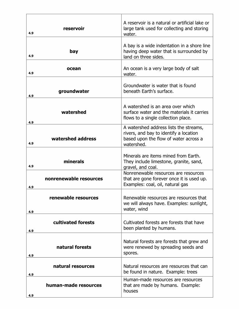
reservoir 4.9
A reservoir is a natural or artificial lake or large tank used for collecting and storing water.
bay 4.9
A bay is a wide indentation in a shore line having deep water that is surrounded by land on three sides.
ocean
4.9
An ocean is a very large body of salt water.
groundwater 4.9
Groundwater is water that is found beneath Earth’s surface.
watershed 4.9
A watershed is an area over which surface water and the materials it carries flows to a single collection place.
watershed address 4.9
A watershed address lists the streams, rivers, and bay to identify a location based upon the flow of water across a watershed.
minerals 4.9
Minerals are items mined from Earth. They include limestone, granite, sand, gravel, and coal.
nonrenewable resources
4.9
Nonrenewable resources are resources that are gone forever once it is used up. Examples: coal, oil, natural gas
renewable resources
4.9
Renewable resources are resources that we will always have. Examples: sunlight, water, wind
cultivated forests
4.9
Cultivated forests are forests that have been planted by humans.
natural forests 4.9
Natural forests are forests that grew and were renewed by spreading seeds and spores.
natural resources
4.9
Natural resources are resources that can be found in nature. Example: trees
human-made resources
4.9
Human-made resources are resources that are made by humans. Example: houses