Science Plan
65
Science Plan of the Environmental M apping and Analysis P rogram ( EnMAP ) October, 2012
Transcript of Science Plan

Science Planof the Environmental Mapping and Analysis Program (EnMAP)
October, 2012

EnMAP Core Science Team:
Prof. Dr. Hermann Kaufmann (Principle Investigator and Chair)charly[at]gfz-potsdam.deHelmholtz Centre Potsdam, GFZ German Research Centre forGeosciences . . . . . . . . . . . . . . . . . . . . . . . . . . . . . . . . . . .
Prof. Dr. Joachim Hillhillj[at]uni-trier.deUniversity of Trier . . . . . . . . . . . . . . . . . . . . . . . . . . . . . . .
Prof. Dr. Patrick Hostertpatrick.hostert[at]geo.hu-berlin.deHumboldt-University Berlin . . . . . . . . . . . . . . . . . . . . . . . . .
Dr. Hajo Krasemannkrasemann[at]hzg.deHelmholtz-Zentrum Geesthacht . . . . . . . . . . . . . . . . . . . . . . .
Prof. Dr. Wolfram Mauserw.mauser[at]lmu.deLudwig-Maximilian-University München . . . . . . . . . . . . . . . . . .
Dipl. Geol. Andreas Müllerandreas.mueller[at]dlr.deDLR Oberpfaffenhofen . . . . . . . . . . . . . . . . . . . . . . . . . . . . .
Project funding by:
German Federal Ministry of Economics and Technology
Gefördert von der Raumfahrt-Agentur des Deutschen Zentrums
für Luft- und Raumfahrt e.V. mit Mitteln des Bundesministeri-
ums für Wirtschaft und Technologie aufgrund eines Beschlusses des
Deutschen Bundestages unter dem Förderkennzeichen 50 EE 0922
Project management by:
DLR Space Administration
i

Science Plan authors:
H. Kaufmann (1), S. Förster (1), H. Wulf (1), K. Segl (1), L. Guanter (1), M. Bochow (1), U. Heiden (2),A. Müller (2), W. Heldens (2), T. Schneiderhan (2), P.J. Leitão (3), S. van der Linden (3), P. Hostert (3),J. Hill (4), H. Buddenbaum (4), W. Mauser (5), T. Hank (5), H. Krasemann (6), R. Röttgers (6), N.Oppelt (7), B. Heim(8),
(1) Helmholtz Centre Potsdam, German Research Centre For Geosciences (GFZ)(2) German Aerospace Centre (DLR)(3) Humboldt-Universität zu Berlin(4) Trier University(5) Ludwig-Maximilian-Universität München (LMU)(6) Helmholtz-Zentrum Geesthacht, Centre for Materials and Coastal Research (HZG)(7) University Kiel(8) Alfred Wegener Institute for Polar and Marine Research - Research Unit Potsdam (AWI)
Cite this document as follows:
Kaufmann et al. (2012): Science Plan of the Environmental Mapping and Analysis Program (EnMAP).Potsdam: Deutsches GeoForschungsZentrum GFZ, 65 pp. Scientific Technical Report
ii

Contents
1 Introduction 1
1.1 The EnMAP mission . . . . . . . . . . . . . . . . . . . . . . . . . . . . . . . . . . . . . . 1
1.2 Scope of the document . . . . . . . . . . . . . . . . . . . . . . . . . . . . . . . . . . . . . 1
1.3 Terms and abbreviations . . . . . . . . . . . . . . . . . . . . . . . . . . . . . . . . . . . . . 2
2 Research context and significance 3
2.1 Major environmental challenges . . . . . . . . . . . . . . . . . . . . . . . . . . . . . . . . 3
2.2 EnMAP mission objectives . . . . . . . . . . . . . . . . . . . . . . . . . . . . . . . . . . . 4
2.3 Overarching research themes . . . . . . . . . . . . . . . . . . . . . . . . . . . . . . . . . . 5
2.4 European and International stakeholders . . . . . . . . . . . . . . . . . . . . . . . . . . . 6
3 General mission framework 8
3.1 Technical parameters . . . . . . . . . . . . . . . . . . . . . . . . . . . . . . . . . . . . . . . 8
3.2 Data processing, calibration, and validation . . . . . . . . . . . . . . . . . . . . . . . . . . 8
3.3 Data products and access . . . . . . . . . . . . . . . . . . . . . . . . . . . . . . . . . . . . 10
4 Hyperspectral remote sensing 13
4.1 Principles of imaging spectroscopy . . . . . . . . . . . . . . . . . . . . . . . . . . . . . . . 13
4.2 Imaging spectroscopy missions . . . . . . . . . . . . . . . . . . . . . . . . . . . . . . . . . 16
4.3 Synergies with other sensors . . . . . . . . . . . . . . . . . . . . . . . . . . . . . . . . . . 17
5 EnMAP perspectives and impact 19
5.1 Terrestrial Ecosystems . . . . . . . . . . . . . . . . . . . . . . . . . . . . . . . . . . . . . . 20
5.1.1 Natural ecosystems and ecological gradients . . . . . . . . . . . . . . . . . . . . . . 20
5.1.2 Forests . . . . . . . . . . . . . . . . . . . . . . . . . . . . . . . . . . . . . . . . . . . 21
5.1.3 Cryospheric ecosystems . . . . . . . . . . . . . . . . . . . . . . . . . . . . . . . . . 23
5.1.4 Agricultural land . . . . . . . . . . . . . . . . . . . . . . . . . . . . . . . . . . . . . 25
5.1.5 Urban areas . . . . . . . . . . . . . . . . . . . . . . . . . . . . . . . . . . . . . . . . 27
5.2 Aquatic Ecosystems . . . . . . . . . . . . . . . . . . . . . . . . . . . . . . . . . . . . . . . 29
5.2.1 Coastal and inland water . . . . . . . . . . . . . . . . . . . . . . . . . . . . . . . . 29
5.2.2 Oceans . . . . . . . . . . . . . . . . . . . . . . . . . . . . . . . . . . . . . . . . . . 31
5.3 Natural Resource Management . . . . . . . . . . . . . . . . . . . . . . . . . . . . . . . . . 32
5.3.1 Resource investigations . . . . . . . . . . . . . . . . . . . . . . . . . . . . . . . . . 32
5.3.2 Environmental rehabilitation . . . . . . . . . . . . . . . . . . . . . . . . . . . . . . 34
iii

5.4 Hazards and Risks . . . . . . . . . . . . . . . . . . . . . . . . . . . . . . . . . . . . . . . . 34
5.4.1 Disaster management . . . . . . . . . . . . . . . . . . . . . . . . . . . . . . . . . . 35
5.4.2 Natural hazards . . . . . . . . . . . . . . . . . . . . . . . . . . . . . . . . . . . . . 36
5.4.3 Man-made hazards . . . . . . . . . . . . . . . . . . . . . . . . . . . . . . . . . . . . 37
5.5 Atmospheric Research . . . . . . . . . . . . . . . . . . . . . . . . . . . . . . . . . . . . . . 39
6 Scientific exploitation strategy 40
6.1 Community information and public awareness . . . . . . . . . . . . . . . . . . . . . . . . . 40
6.2 Community building and training . . . . . . . . . . . . . . . . . . . . . . . . . . . . . . . . 40
6.3 Thematic and regional areas of interest . . . . . . . . . . . . . . . . . . . . . . . . . . . . . 42
Acknowledgement 44
References 45
Annex 57
Tables . . . . . . . . . . . . . . . . . . . . . . . . . . . . . . . . . . . . . . . . . . . . . . . . . . 57
List of Figures . . . . . . . . . . . . . . . . . . . . . . . . . . . . . . . . . . . . . . . . . . . . . 58
List of Tables . . . . . . . . . . . . . . . . . . . . . . . . . . . . . . . . . . . . . . . . . . . . . . 59
iv

1. Introduction
1.1 The EnMAP mission
The Environmental Mapping and Analysis Program (EnMAP) is a German hyperspectral satellite mis-sion that aims at monitoring and characterising the Earth’s environment on a global scale. EnMAPserves to measure and model key dynamic processes of the Earth’s ecosystems by extracting geochemi-cal, biochemical and biophysical parameters, which provide information on the status and evolution ofvarious terrestrial and aquatic ecosystems. Once operating, EnMAP will provide unique data neededto address major environmental problems related to human activity and climate change. The mission’smain objective is to study and decipher coupled environmental processes and to assist and promote thesustainable management of the Earth’s resources. Despite being a primarily scientific mission, EnMAPhas a clear potential to evolve towards operational service.
The EnMAP mission consortium comprises the Helmholtz Centre Potsdam - German ResearchCentre for Geosciences (GFZ) as the principal scientific investigator, Kayser-Threde as the industrialprime contractor, OHB Systems AG providing the satellite service module, German Aerospace Agency(DLR) - Space Administration managing the project, and DLR Oberpfaffenhofen, which is responsiblefor the ground segment.
1.2 Scope of the document
The scope of this Science Plan is to describe the scientific background, applications, and activities relatedto the EnMAP mission. Primarily, the Science Plan addresses scientists and funding institutions, but itmay also be of interest for environmental stakeholders and governmental bodies. It is conceived to be aliving document that will be updated throughout the whole mission.
Current global challenges call for interdisciplinary approaches. Hence, the science plan is not struc-tured in the traditional disciplinary way. Instead, it builds on overarching research themes to whichEnMAP can contribute. This Science Plan comprises the following five chapters presenting the signifi-cance, background, framework, applications, and strategy of the EnMAP mission: Chapter 2 highlightsthe need for EnMAP data with respect to major environmental issues and various stakeholders. Thischapter states the mission’s main objectives and provides a list of research themes addressing global chal-lenges to whose understanding and management EnMAP can contribute. Chapter 3 presents an overviewof the EnMAP mission from a scientific point of view including a brief description of the mission pa-rameters, data products and access, and calibration/validation issues. Chapter 4 provides an overviewof hyperspectral remote sensing regarding its principles, development, and current state and synergies toother satellite missions. Chapter 5 describes current lines of research and EnMAP applications to ad-dress the research themes presented in Chapter 2. Finally, Chapter 6 outlines the scientific exploitationstrategy, which includes the strategy for community building, dissemination of knowledge and increasingpublic awareness.
1
Chapter 1. Introduction
1.3 Terms and abbreviations
Throughout this document we use the term imaging spectroscopy synonymously for hyperspectral imag-ing. We refer to EnMAP as the hyperspectral imager containing two sensors, one for visual/near-infraredrange and one for the shortwave-infrared range. Furthermore, we refer to the EnMAP satellite as theentity composed of the sensors and service module and to the EnMAP mission as all activities relatedto the EnMAP satellite. In the context of the EnMAP mission a wide spectrum of technical and man-agement terms and abbreviations are used. The EnMAP mission team has built up a Glossary of Termsand Abbreviations that comprises contributions from many team members and is continuously updatedand extended. The glossary is publicly available at http://www.enmap.org/cms.
2
2. Research context and significance
2.1 Major environmental challenges
Humanity faces fundamental challenges in the 21st century. Most prominently, we need to mitigate andadapt to climate change impacts, achieve a sustainable global land use, halt environmental degrada-tion processes, and ensure resource sustainability. These closely linked aspects need to be understood,quantified, and managed as they put increasing pressure on society and the environment (ESA, 2006).
The interference of humankind with the Earth’s atmosphere, biosphere, pedosphere, and hydro-sphere has greatly increased during the last century. One of the most comprehensive impacts of thesedisturbances is the increase in air temperature, which is driven by increasing emissions of greenhousegases. Over the last 50 years, Earth’s mean near-surface air temperature increased by 0.13 °C per decade(IPCC , 2007). This trend in global warming drives a range of phenomena such as reduced snow andglacial cover, rising sea level, and increased occurrences of droughts and fires. These phenomena in turnshow feedback mechanisms to the climate system via modifications in albedo, ocean circulation, andbiogeochemical cycles.
Further global perturbations of the Earth System include the decline of water and air quality bywidespread emission of pollutants and the decline of ecosystem services, which is interrelated to theloss of biodiversity, due to large-scale land cover changes. Nearly half of Earth’s land surface has beentransformed by direct human action with more than one quarter of the world’s forests cleared (Vitousek ,1997) and one quarter of the land degraded (FAO , 2011). For several decades we reduced the diversityof life by polluting the environment, fragmenting habitats, spreading pathogens and invasive species, andchanging global climate (e.g. Dirzo and Raven, 2003). These multiple, atypical high-intensity ecologicalstressors drive a continuous loss in biodiversity (Barnosky et al., 2011) and compromise vital ecosystemservices such as clean air, fresh water, and food (e.g. Loreau et al., 2001).
Over the next 50 years, increased population and improved living standards are expected to promptmajor increases in global food demand (von Braun et al., 2005). Resulting increases in food productionwill be driven in large by intensified land use because further expansion of arable land area is limited andfreshwater supplies are diminishing (IGOS , 2008). Likewise, the increasing demand of rising populationnumbers and growing economies for resources like energy, food, water, and land will remain a major driverof global change and environmental degradation. In turn, climate change and environmental stress willcontinue to put increasing pressure on many vulnerable communities. Extreme weather conditions liketropical cyclones, rainstorms, and heat waves resulted repeatedly in loss of life, property, and agriculturalgoods (e.g. IPCC , 2012). Further hazards like floods and landslides are associated with the continuous sealevel rise, permafrost degradation, and widespread glacial retreat (Kollmair and Banerjee, 2011; Vafeidiset al., 2011). In essence, we need to understand and quantify the consequences of human activities as ascientific basis for policy, decision-making, planning, and a sustainable land and resource management.
Our ability to address these increasingly urgent risks also depends on an improved detection andunderstanding of relevant processes. During the past decades hyperspectral remote sensing emerged as
3
Chapter 2. Research context and significance
a valuable tool to assess and quantify a broad range of surface processes within the Earth System (e.g.Goetz et al., 1985; Schaepman et al., 2009). The availability of high quality hyperspectral imagery on afrequent basis will thus significantly contribute to the understanding of coupled processes and complexfeedback mechanisms across different spheres. Against this background, EnMAP represents an ambitiousmission to offer accurate, diagnostic information on the state and dynamics of terrestrial and aquaticecosystems. Its future capability to repeatedly observe various locations of the Earth’s surface in a highspatial and advanced spectral resolution opens up new possibilities to characterize ecosystem conditions(i.e. vegetation state, water quality, and soil properties) and to assess future trends. EnMAP is of keyimportance to monitor environmental degradation and change and it will contribute to improved conceptsfor sustainable management of land and other natural resources.
2.2 EnMAP mission objectives
The main scientific goal of the hyperspectral EnMAP mission is to study environmental changes, inves-tigate ecosystem responses to human activities, and monitor the management of natural resources. Bymeasuring diagnostic parameters that quantify the state and trend of environmental change, the stabil-ity of ecosystems, and the sustainability of resource use, the EnMAP mission aims to provide criticalinformation for an improved understanding and management of the Earth System.
The primary mission objectives are:
• to provide high-quality calibrated hyperspectral data for advanced remote sensing analyses;
• to foster and develop novel methodologies that improve the accuracy of currently available remotesensing information and to provide advanced science-driven information products;
• to obtain diagnostic geochemical, biochemical and biophysical parameters that describe the sta-tus and dynamics of various ecosystems to improve our understanding of complex environmentalprocesses;
• to provide information products that can serve as input for advanced ecosystem models;
• to significantly contribute to environmental research studies, particularly in the fields of ecosystemfunctions, natural resource management, natural hazards and Earth system modelling; and
• to develop new concepts and techniques for data extraction and assimilation to achieve synergieswith other sensors.
EnMAP will significantly increase the availability of currently infrequent hyperspectral measurementscovering large areas. To understand and fully exploit the information content provided by EnMAP, novelevaluation techniques need to be developed which fully utilize EnMAP’s regional coverage on a globalscale. EnMAP data will provide the unique opportunity to adapt and extrapolate existing hyperspectralacquisition and data analysis approaches derived from laboratory-, field-, and airborne measurements tospaceborne imagery. Their integration in regional ecosystem models will allow to complement, enhance,and extend current local case study findings to a regional scale. Consolidated and improved regional scalescience on the state and evolution of ecosystems is the prerequisite for improvements in global ecosystemmodels. Such upscaling studies require a sensible generalisation of the derived quantitative ecosystemparameters and the synergistic analysis with other spaceborne imagery such as provided by the futureSentinel fleet.
Owing to the 30° across track off-nadir pointing capability, EnMAP is highly suited for repeatedcoverage of multiple key target sites with a maximum revisit cycle of 4 days. This ability allows EnMAP
4
Chapter 2. Research context and significance
to repeatedly observe a globally distributed network of local to regional key target sites during its fiveyears of mission operation. Based on this multiple-observation strategy EnMAP will provide highlyresolved time-series to decipher the response of different ecosystems on natural and man-made pressures,such as climate change, urban sprawl, land use changes, natural hazards, and environmental pollution.This overall aim is linked to several secondary objectives that tackle pressing research topics as presentedin the following section.
2.3 Overarching research themes
EnMAP’s repeated observations with an advanced spectral coverage and resolution will provide newinsights into multiple interrelated environmental subjects. The EnMAP Core Science Team identifiedseveral research topics, grouped in five major environmental themes, to which EnMAP data can providea substantial contribution. Because hyperspectral image analysis is applicable to a wide range of researchtopics this selection focuses only on some of the most challenging environmental subjects.
Terrestrial Ecosystems
Keywords: Ecosystem services, Biodiversity, Species migration, Precision farming, REDD, Urban growth
• Quantifying the impact of human activities such as land use/cover change, land management prac-tices, and environmental pollution on ecosystems, their services and biodiversity.
• Quantifying the rate and consequences of ecosystem changes (e.g. biodiversity loss, species migra-tion).
• Monitoring measures to combat biodiversity loss and improve ecosystem stability (e.g. REDD+).
• Assessing the impact of soot and dust on snow and glacial melt and the consequences for thehydrological cycle.
• Analysing the state and development of urban compositions and growth.
Aquatic Ecosystems
Keywords: Water quality, Water constituents, Environmental pollution, Phytoplankton diversity
• Assessing the impact of environmental pollution on water quality.
• Analysing the spatiotemporal variability of phytoplankton and other water constituents, whichprovide insights in aquatic ecological changes.
• Discriminating water constituents (e.g. chlorophyll) to assess the water quality of freshwater reser-voirs and aquaculturally used coastal and inland water bodies.
• Analysing type, status, and changes of shallow sea/lake bottom substrate (e.g. vegetation types,sediment dynamics).
Natural Resource Management
Keywords: Mineral deposits, Soil properties, Environmental rehabilitation
• Developing methods to explore and manage geo-resources, such as ore/mineral deposits and petroleum,in a sustainable way.
5
Chapter 2. Research context and significance
• Quantifying the extent of environmental pollution caused by mine wastes and monitoring the envi-ronmental rehabilitation progress.
• Monitoring measures to support sustainable resource management (e.g. forest ecosystems, arableland).
Hazards and Risks
Keywords: Disaster management, Extreme weather conditions, Landslides, Volcanoes, Floods, Landdegradation, Oil spills, Marine debris, Industrial waste
• Quantifying the degree and extend of destruction in the event of a natural disaster to provide acoordinated short-term emergency response and a long-term risk management.
• Analysing the impact of extreme weather conditions (e.g. droughts, heat waves, hurricanes) onecosystems and agriculture.
• Quantifying the degree and extent of environmental pollution caused by oil spills, marine litter,mine wastes, or industrial chemicals and the environmental rehabilitation progress.
• Quantifying land degradation processes (e.g. desertification, salinization, soil acidification, soilerosion) and their impact on ecosystem services.
• Assessing the susceptibility of areas/communities towards natural hazards (e.g. fires, floods, land-slides) and the rate and nature of change in their vulnerability.
Atmospheric Research
Keywords: Columnar water vapour, Mineral dust, Pollen
• Improve algorithms to retrieve columnar water vapour, mineral dust, particulate matter clouds andpollen.
2.4 European and International stakeholders
The products and information generated from EnMAP data will be of substantial interest for the scientificcommunity, several European and International organizations, and the general public. References to thefollowing organizations, initiatives and agreements can be found in the Annex (Table A.1).
First and foremost, researchers need EnMAP data to improve their understanding of Earth sur-face processes and reduce uncertainties in associated ecosystem models. Scientific requirements for ter-restrial observations have long been articulated, especially at the international level, by the Interna-tional Geosphere-Biosphere Program (IGBP), the Land Ocean Interaction in the Coastal Zone Program(LOICZ), the International Human Dimensions Program (IHDP), DIVERSITAS, the World Climate Re-search Program (WCRP), Global Land Project (GLP), Global Biodiversity Information Facility (GBIF),Millennium Ecosystem Assessment (MA), and the Global Environment Outlook (GEO) (GLP , 2005).The major new “Future Earth” alliance on Earth system research for global sustainability integrates andconsolidates the above mentioned international expertise in environmental and social science under oneumbrella and forms the programmatic and societal justification for the EnMAP-based science.
Key international stakeholders, who rely in their future work on the scientific results of the EnMAPmission, include organizations that make up the United Nations System (e.g. UNEP, FAO, UNESCO
6

Chapter 2. Research context and significance
and WMO). Furthermore, selected UN System organizations, alongside the Intergovernmental Oceano-graphic Commission and International Council for Science, sponsor the Global Climate Observing Systems(GCOS), Global Ocean Observing System (GOOS) and Global Terrestrial Observing System (GTOS).These three bodies are also important stakeholders as they provide advice on needs, gaps, and futuredevelopments of observations as required by the UN System, by multilateral environmental agreements(REDD+, UNFCCC, UNCCD, CBD, etc.), and by associated key entities, such as the IntergovernmentalPanel on Climate Change (IPCC), the Intergovernmental Platform on Biodiversity & Ecosystem Services(IPBES) and the International Union for Conservation of Nature (IUCN) (IGOS , 2008).
At the level of the European Union several Commission directories (e.g., DG VI - Agriculture,DG VIII - Development, DG XI - Environment, DG XII - Transport, and DG XVI - Regional policy)are anticipated to require continuous remotely sensed land observations because these governmentaldepartments need to set, monitor, and enforce their policy agenda. For example, specified biological,hydromorphological and physico-chemical parameters of water bodies have to be monitored on a regularbasis according to the EU Water Framework Directive. In addition, national/local authorities will needincreasingly detailed information for implementing local measures to combat desertification and to planalternative land uses. Furthermore, this information will be useful in meeting the objectives of theaction plans concerning the protection of the Mediterranean Sea against telluric pollution (BarcelonaConvention, Mediterranean Action Plan). Against this background, data products (e.g., soil status,vegetation cover, change detection maps, degradation index maps) will be beneficial for decision makers.In particular, the European Earth monitoring programme GMES (Global Monitoring for Environmentand Security) requires environmental information to support critical decisions of policymakers and publicauthorities on environmental legislation and policies with a particular focus on climate change and naturalor man-made catastrophes.
Furthermore, the general public has an increasing interest in many aspects of global environmentalchange, which is also reflected by political developments. The Aarhus Convention codifies the Europeancitizen’s participation in environmental issues and provides a legal framework for access to informationon the environment held by public authorities (IGOS , 2008).
7

3. General mission framework
3.1 Technical parameters
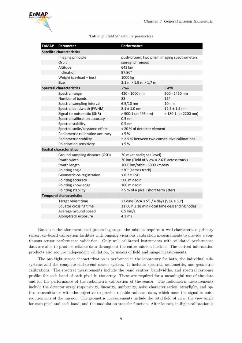
The EnMAP satellite carries a push-broom type hyperspectral imager, that records reflected radiationfrom the Earth surface in the wavelength region from 420 nm to 2450 nm via 242 contiguous bands.The visible/near infrared (VNIR) range is covered by 88 bands with a mean band width of 6.5 nm andthe short wave infrared (SWIR) range is covered by 154 bands with a band width of 10 nm. Accurateradiometric and spectral responses are ensured by a sufficient signal-to-noise ratio of ≥400:1 in the VNIRand ≥170:1 in the SWIR (based on an albedo of 30% and a solar zenith angle of 30°), a radiometriccalibration accuracy of better than 5%, and a spectral calibration uncertainty of 0.5 nm in the VNIR andSWIR.
The sensor is characterized by a ground sampling distance of 30 m (nadir at sea level) and providesa swath width of 30 km. EnMAP can record strip lengths of up to 1000 km with a capacity of 5000km per day. The nominal target revisit time of 23 days can be reduced to 4 days by use of the acrosstrack off-nadir pointing capability of ±30°. EnMAP will be launched in a sun-synchronous orbit (653 kmheight at 48°N; 97.96° inclination) with a local equatorial crossing time of 11:00 hr. The satellite launchis scheduled for 2017 with an Indian “Polar Satellite Launch Vehicle” and has a designed lifetime of fiveyears. A summary of all mission/instrument details is given in Table 1.
3.2 Data processing, calibration, and validation
Hyperspectral data are usually supplied as spectral radiance data (e.g. Watts per square centimetre persteradian per micrometre). The identification of pigments and materials such as minerals is based on thespectral reflectance characteristics of the target surface. Consequently, the internal calibration of the sen-sor and the methodological approach in the conversion of at-sensor radiance into surface reflectance areof utmost importance for the accuracy and subsequent processing and evaluation of data. The conversionprocesses from radiance to spectral reflectance involve three main steps. The first step accomplishes thenormalisation of the radiance data by the actual spectral solar insolation intensity for each spectral bandof the given sensor (Thuillier et al., 1998; Green and Gao, 1993; Staenz et al., 1995). This transformsthe radiance data acquired by a sensor into at-sensor bi-directional reflectance data. Secondly, the at-sensor-reflectance-data are converted into surface-reflectances through the application of an atmosphericcorrection scheme, which compensates for atmospheric scattering (Rayleigh and Mie), molecular absorp-tion (H2O, O2, O3, CO2, NO2 or CH4), and aerosols (Conel et al., 1988; Berk et al., 1998; Richter , 1996).The third step contains the correction of these surface reflectance spectra for relief (elevation, slope andaspect) and macroscopic surface roughness (Richter , 1998). The resulting reflectance spectra can thenbe compared to existing spectral libraries compiled mainly from laboratory and field measurements. Thecomparison is also dependent on BRDF (Bidirectional Reflectance Distribution Function) characteristicsof the target (different illumination and observation geometry) and mixed-pixel problems.
8
Chapter 3. General mission framework
Table 1: EnMAP satellite parameters
Based on the aforementioned processing steps, the mission requires a well-characterized primarysensor, on-board calibration facilities with ongoing vicarious calibration measurements to provide a con-tinuous sensor performance validation. Only well calibrated instruments with validated performancedata are able to produce reliable data throughout the entire mission lifetime. The derived informationproducts also require independent validation, by means of field and image measurements.
The pre-flight sensor characterization is performed in the laboratory for both, the individual sub-systems and the complete end-to-end sensor system. It includes spectral, radiometric, and geometriccalibrations. The spectral measurements include the band centres, bandwidths, and spectral responseprofiles for each band of each pixel in the array. These are required for a meaningful use of the dataand for the performance of the radiometric calibration of the sensor. The radiometric measurementsinclude the detector array responsivity, linearity, uniformity, noise characterization, straylight, and op-tics transmittance with the objective to provide reliable radiance data, which meet the signal-to-noiserequirements of the mission. The geometric measurements include the total field of view, the view anglefor each pixel and each band, and the modulation transfer function. After launch, in-flight calibration is
9

Chapter 3. General mission framework
carried out using onboard calibration devices such as the Solar Full Aperture Diffuser for the absoluteradiometric calibration using the sun as the known reference, a Main Sphere for the relative radiometriccalibration, a Small Sphere for spectral characterization, Focal Plane Assembly LEDs for non-linearitycalibration and a Shutter for dark current calibration. These measurements will be complemented byvicarious calibration experiments on demand. As the imaging spectrometer and the on-board calibrationinstrumentation age, there is a growing need for periodic in-flight calibration vicarious and on-boardcalibrations.
Validation of the EnMAP L1, L2geo, L2atm and L2 products (see section 3.3) will be performedduring the commissioning phase and the operational mission period. The validation procedure includesground- and scene-based techniques for the product evaluation to derive characteristic error estimates forthe final EnMAP products and detailed information to track potential error sources back to instrumentand processing chain levels. These validation results will be incorporated in calibration activities andwill be provided as additional information on the instrument spectral and radiometric performance.The purpose of these calibration and validation measurements is to provide data products with a highradiometric and geometric accuracy throughout the operational mission time.
3.3 Data products and access
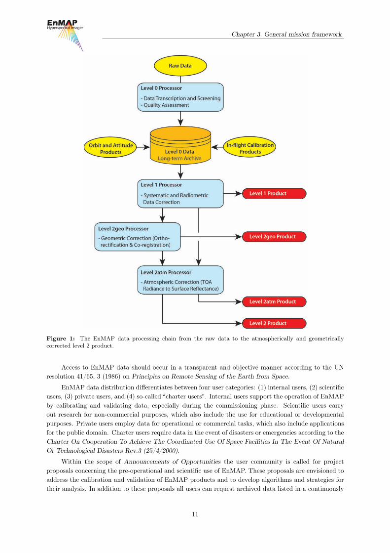
During the operation phase, the following four EnMAP data products will be delivered to the usercommunity: Product Level 1, Product Level 2geo, Product Level 2atm, and Product Level 2. Pleasenote that the raw data and its processed Level 0 (cf. Figure 1) product are not available to the usercommunity.
The Level 1 product represents the top-of-atmosphere radiance. This product is radiometricallycalibrated, spectrally characterized, geometrically characterized, quality controlled, and annotated withpreliminary pixel classification (usability mask). The auxiliary information (e.g. position and pointingvalues, interior orientation parameters, gain and offset) necessary for further processing is attached, butnot applied. The Level 1 processor corrects the hyperspectral image for known effects, e.g. radiometricnon-uniformities, and converts the system corrected data to physical at-sensor radiance values based onthe currently valid radiometric calibration values and dark current measurements.
The Level 2geo product represents geocoded top-of-atmosphere values. This product is derivedfrom the Level 1 product, which is subsequently geometrically corrected (orthorectified) and re-sampledto a specified grid. Auxiliary data for further processing are attached, but not applied. The Level 2geoprocessor creates ortho-images by direct geo-referencing, utilizing an adequate digital elevation model.The extraction of ground-control-points from existing reference images using image matching techniquesserve to improve the line-of-sight vector and therefore to increase the geometric accuracy of the ortho-images. The Level 2geo processor ortho-rectifies image tiles from the VNIR and SWIR instrumentindependently. After ortho-rectification the two image tiles are co-registered (better than 0.2 pixel size)and form a geometrically consistent product over the whole wavelength range.
The Level 2atm product represents scaled ground reflectance values. This product is derived fromthe Level 1 product. The data are then converted to ground surface reflectance values after an atmosphericcorrection that assumes a flat terrain. Auxiliary data for further processing are attached, but not applied.The Level 2atm processor will convert the physical at-sensor radiance values to surface reflectance valuesseparately for land and water applications. This includes the estimation of the aerosol optical thicknessand the columnar water vapour.
The Level 2 product represents the ground surface reflectance. This product is derived from theLevel 2geo product, atmospherically corrected, and converted to ground surface reflectance values. Mostapplications are envisioned to use the Level 2 product for further analysis.
10
Chapter 3. General mission framework
Figure 1: The EnMAP data processing chain from the raw data to the atmospherically and geometricallycorrected level 2 product.
Access to EnMAP data should occur in a transparent and objective manner according to the UNresolution 41/65, 3 (1986) on Principles on Remote Sensing of the Earth from Space.
EnMAP data distribution differentiates between four user categories: (1) internal users, (2) scientificusers, (3) private users, and (4) so-called “charter users”. Internal users support the operation of EnMAPby calibrating and validating data, especially during the commissioning phase. Scientific users carryout research for non-commercial purposes, which also include the use for educational or developmentalpurposes. Private users employ data for operational or commercial tasks, which also include applicationsfor the public domain. Charter users require data in the event of disasters or emergencies according to theCharter On Cooperation To Achieve The Coordinated Use Of Space Facilities In The Event Of NaturalOr Technological Disasters Rev.3 (25/4/2000).
Within the scope of Announcements of Opportunities the user community is called for projectproposals concerning the pre-operational and scientific use of EnMAP. These proposals are envisioned toaddress the calibration and validation of EnMAP products and to develop algorithms and strategies fortheir analysis. In addition to these proposals all users can request archived data listed in a continuously
11

Chapter 3. General mission framework
updated data catalogue. After the end of the commissioning phase all data will be stored, maintained,and distributed by German Aerospace Agency (DLR) for at least 20 years.
The EnMAP portal (www.enmap.org) is the central entry point for all national and internationalusers interested in learning about the EnMAP mission, its objectives, status, data products and processingchains. Additionally, this platform informs about the conditions and requirements for the EnMAP dataaccess and the ongoing scientific programs and activities.
12
4. Hyperspectral remote sensing
4.1 Principles of imaging spectroscopy
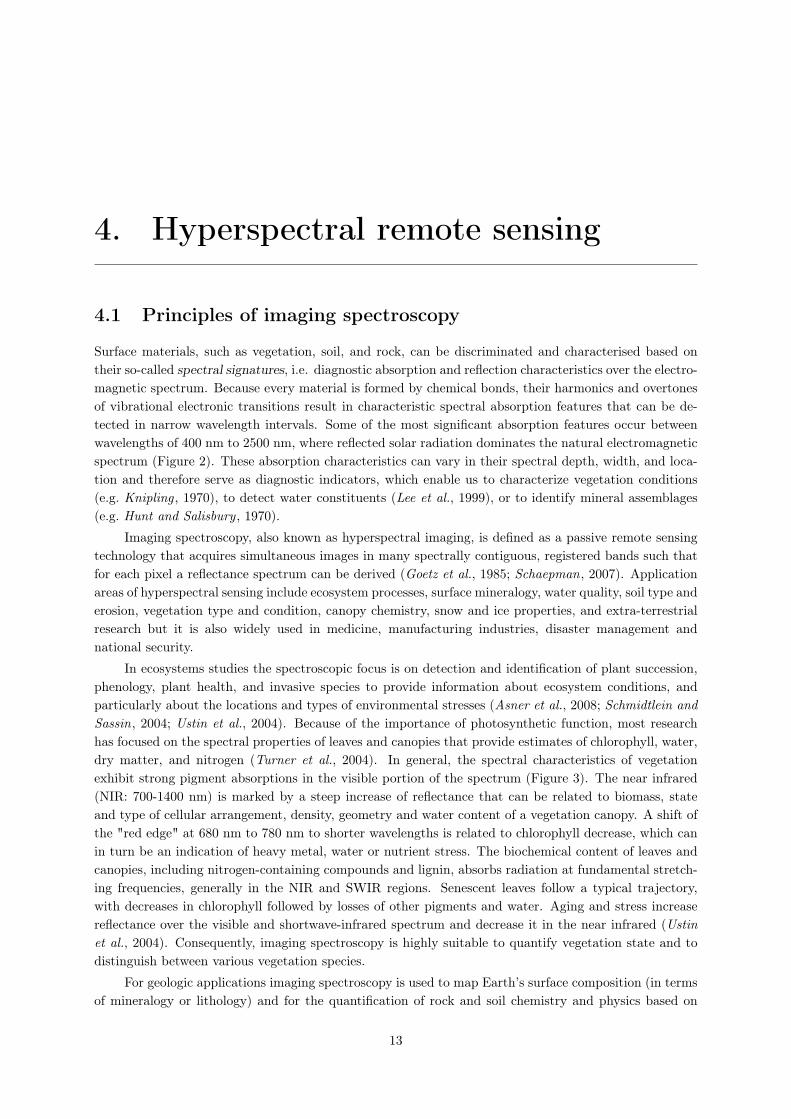
Surface materials, such as vegetation, soil, and rock, can be discriminated and characterised based ontheir so-called spectral signatures, i.e. diagnostic absorption and reflection characteristics over the electro-magnetic spectrum. Because every material is formed by chemical bonds, their harmonics and overtonesof vibrational electronic transitions result in characteristic spectral absorption features that can be de-tected in narrow wavelength intervals. Some of the most significant absorption features occur betweenwavelengths of 400 nm to 2500 nm, where reflected solar radiation dominates the natural electromagneticspectrum (Figure 2). These absorption characteristics can vary in their spectral depth, width, and loca-tion and therefore serve as diagnostic indicators, which enable us to characterize vegetation conditions(e.g. Knipling , 1970), to detect water constituents (Lee et al., 1999), or to identify mineral assemblages(e.g. Hunt and Salisbury , 1970).
Imaging spectroscopy, also known as hyperspectral imaging, is defined as a passive remote sensingtechnology that acquires simultaneous images in many spectrally contiguous, registered bands such thatfor each pixel a reflectance spectrum can be derived (Goetz et al., 1985; Schaepman, 2007). Applicationareas of hyperspectral sensing include ecosystem processes, surface mineralogy, water quality, soil type anderosion, vegetation type and condition, canopy chemistry, snow and ice properties, and extra-terrestrialresearch but it is also widely used in medicine, manufacturing industries, disaster management andnational security.
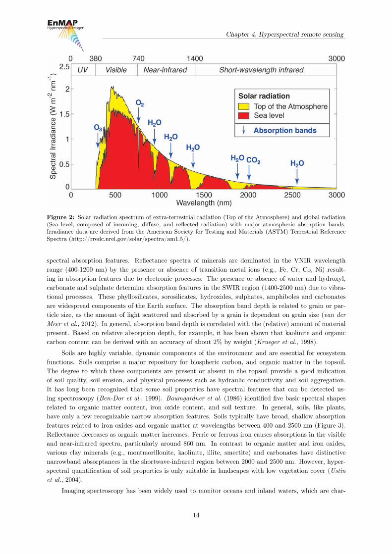
In ecosystems studies the spectroscopic focus is on detection and identification of plant succession,phenology, plant health, and invasive species to provide information about ecosystem conditions, andparticularly about the locations and types of environmental stresses (Asner et al., 2008; Schmidtlein andSassin, 2004; Ustin et al., 2004). Because of the importance of photosynthetic function, most researchhas focused on the spectral properties of leaves and canopies that provide estimates of chlorophyll, water,dry matter, and nitrogen (Turner et al., 2004). In general, the spectral characteristics of vegetationexhibit strong pigment absorptions in the visible portion of the spectrum (Figure 3). The near infrared(NIR: 700-1400 nm) is marked by a steep increase of reflectance that can be related to biomass, stateand type of cellular arrangement, density, geometry and water content of a vegetation canopy. A shift ofthe "red edge" at 680 nm to 780 nm to shorter wavelengths is related to chlorophyll decrease, which canin turn be an indication of heavy metal, water or nutrient stress. The biochemical content of leaves andcanopies, including nitrogen-containing compounds and lignin, absorbs radiation at fundamental stretch-ing frequencies, generally in the NIR and SWIR regions. Senescent leaves follow a typical trajectory,with decreases in chlorophyll followed by losses of other pigments and water. Aging and stress increasereflectance over the visible and shortwave-infrared spectrum and decrease it in the near infrared (Ustinet al., 2004). Consequently, imaging spectroscopy is highly suitable to quantify vegetation state and todistinguish between various vegetation species.
For geologic applications imaging spectroscopy is used to map Earth’s surface composition (in termsof mineralogy or lithology) and for the quantification of rock and soil chemistry and physics based on
13
Chapter 4. Hyperspectral remote sensing
Figure 2: Solar radiation spectrum of extra-terrestrial radiation (Top of the Atmosphere) and global radiation(Sea level, composed of incoming, diffuse, and reflected radiation) with major atmospheric absorption bands.Irradiance data are derived from the American Society for Testing and Materials (ASTM) Terrestrial ReferenceSpectra (http://rredc.nrel.gov/solar/spectra/am1.5/).
spectral absorption features. Reflectance spectra of minerals are dominated in the VNIR wavelengthrange (400-1200 nm) by the presence or absence of transition metal ions (e.g., Fe, Cr, Co, Ni) result-ing in absorption features due to electronic processes. The presence or absence of water and hydroxyl,carbonate and sulphate determine absorption features in the SWIR region (1400-2500 nm) due to vibra-tional processes. These phyllosilicates, sorosilicates, hydroxides, sulphates, amphiboles and carbonatesare widespread components of the Earth surface. The absorption band depth is related to grain or par-ticle size, as the amount of light scattered and absorbed by a grain is dependent on grain size (van derMeer et al., 2012). In general, absorption band depth is correlated with the (relative) amount of materialpresent. Based on relative absorption depth, for example, it has been shown that kaolinite and organiccarbon content can be derived with an accuracy of about 2% by weight (Krueger et al., 1998).
Soils are highly variable, dynamic components of the environment and are essential for ecosystemfunctions. Soils comprise a major repository for biospheric carbon, and organic matter in the topsoil.The degree to which these components are present or absent in the topsoil provide a good indicationof soil quality, soil erosion, and physical processes such as hydraulic conductivity and soil aggregation.It has long been recognized that some soil properties have spectral features that can be detected us-ing spectroscopy (Ben-Dor et al., 1999). Baumgardner et al. (1986) identified five basic spectral shapesrelated to organic matter content, iron oxide content, and soil texture. In general, soils, like plants,have only a few recognizable narrow absorption features. Soils typically have broad, shallow absorptionfeatures related to iron oxides and organic matter at wavelengths between 400 and 2500 nm (Figure 3).Reflectance decreases as organic matter increases. Ferric or ferrous iron causes absorptions in the visibleand near-infrared spectra, particularly around 860 nm. In contrast to organic matter and iron oxides,various clay minerals (e.g., montmorillonite, kaolinite, illite, smectite) and carbonates have distinctivenarrowband absorptances in the shortwave-infrared region between 2000 and 2500 nm. However, hyper-spectral quantification of soil properties is only suitable in landscapes with low vegetation cover (Ustinet al., 2004).
Imaging spectroscopy has been widely used to monitor oceans and inland waters, which are char-
14
Chapter 4. Hyperspectral remote sensing
Figure 3: Reflectance spectra of selected Earth’s surface components. Reflectance data are derived from theUSGS Digital Spectral Library (http://speclab.cr.usgs.gov/spectral.lib06/). The laboratory measurements repre-sent samples of an oak leaf from Colorado (leaf), Aventurine quartz from India (rock), Montmorillonite and Illitefrom Virginia (soil), seawater from the Pacific Ocean (water), fresh snow from Colorado (snow), and black roadasphalt from Colorado (urban).
acterized by an overall high adsorption compared to land surfaces (Figure 3). This optical characteristicmakes water suitable to isolate and measure its optical constituents, such as pigments (e.g. chlorophyll), awide range of phytoplanktonic species, dissolved organics, and suspended non-algal particles (e.g minero-genic sediments). Coastal and inland waters are optically more complex as compared to open oceanicwaters, which can be characterized mainly by one optical parameter and are generally referred to ascase-1 waters (Morel and Prieur , 1977). In contrast, inland and coastal waters are influenced by multipleparameters, which have partly similar optical properties.
Alpine snow cover and its subsequent melt can dominate local to regional climate and hydrologyin the world’s mountainous regions. To model the snowmelt distribution and its impact hyperspectralremote sensing allows for the retrieval of snow properties like snow-covered area, albedo, grain size,liquid water very near the surface, and impurities (Dozier and Painter , 2004). Among natural materialsat the Earth’s surface, snow has a huge range of spectral reflectance values depending on its physicalcharacteristics, primarily the grain size but also dust or soot content, organic substances such as algae,and liquid water (Dozier et al., 2009). Clean, deep snow is highly reflective in the visible spectrum,whereas reflectance in the near-infrared and shortwave-infrared wavelengths shows a general decrease butvary considerable depending primarily on the grain size (Figure 3).
Urban areas are characterized by a wide range of spectrally distinct surface materials, whose spectralsignature is determined by its chemical composition (Heiden et al., 2012). For example, roofing tiles andpolyethylene exhibit pronounced absorption features and high spectral variation, whereas other urbansurfaces such as concrete and asphalt are characterized by low reflectance and low spectral variation.
EnMAP has the capability to detect individual absorption features in the spectra of many mate-rials, solids, liquids, or gases. Actual detection depends on the instrument´s spectral coverage, spectralresolution, spectral sampling, signal-to-noise ratio, the abundance of the material, and the strength ofthe material’s absorption features in the wavelength region measured. The spectral molecular absorption
15

Chapter 4. Hyperspectral remote sensing
and scattering properties of materials, as mentioned in the previous paragraphs, form the basis for theidentification and determination of the abundances of surface and atmospheric constituents. Accord-ingly, research and development efforts within the EnMAP mission employ these fundamental spectralcharacteristics as a basis for the extraction of information from spaceborne hyperspectral data.
Despite the numerous advantages over remotely sensed multispectral or panchromatic data, obtain-ing, (pre-)processing and analysing hyperspectral data is challenging in a variety of ways. (1) The physicaldata size of multidimensional imaging spectroscopy data increases linearly with the number of spectralbands. As a result, the data transfer from satellites to ground stations is limited by downlink capacitiesand processing of hyperspectral data is often time consuming. (2) Atmospheric absorption affects partic-ularly hyperspectral data, which covers the full spectral range between approximately 400 and 2500 nmin narrow bandwidths. Therefore, selective absorption of atmospheric gases in narrow spectral regionsor pronounced absorption by atmospheric water vapour in wider spectral regions requires sophisticatedpre-processing. (3) An overall lower signal-to-noise ratio as compared to multispectral data is anotherissue related to narrow spectral bandwidths and atmospheric attenuations that calls for technologicaladvances and requires advanced processing methods. (4) Another drawback of hyperspectral data isthe significant band-to-band correlation, which results in dimensionality issues and consequently reducesthe total amount of available bands. (5) Furthermore, analysis of imaging spectroscopy data needs toaccount for BRDF effects, which vary as a function of illumination and viewing geometry and depend onthe wavelength as well as structural and optical properties of the surface.
To manage these and other challenges the scientific report "Hyperspectral Algorithms: Report in theframe of EnMAP preparation activities" by Kaufmann et al. (2010) composes the state of the art process-ing algorithms and methodologies to analyse imaging spectroscopy data in diverse research disciplines.Complementary, the EnMAP-Box represents a platform independent software interface, which facilitatesa convenient and straightforward processing and analysing of EnMAP data. For further information referto the EnMAP website (www.enmap.org).
4.2 Imaging spectroscopy missions
Nearly three decades of effort have been devoted to the development of imagers capable of acquiring con-tiguous spectra in different wavelength regions, thereby permitting precise and quantitative analysis ofterrestrial and aquatic ecosystems. These imaging spectrometers have primarily been flown in aircrafts forexperimental and commercial purposes (e.g., AIS, (Vane et al., 1983) FLI and casi (Gower et al., 1992),AVIRIS (Vane et al., 1993), GER/DAIS (Collins and Chang , 1990), SFSI (Neville and Powell , 1992),Hydice (Rickard et al., 1993), MIVIS (Bianchi et al., 1994), HyMap (Cocks et al., 1998), APEX (Schaep-man et al., 2004), AVIS Oppelt and Mauser (2007), AISA (www.spectralcameras.com/aisa), HySpex(www.hyspex.no), and Hyperspec (www.headwallphotonics.com)) (Figure 4). However, data acquisitionfrom an aircraft platform is often restricted by various issues: Varying aircraft attitude changes makegeo-referencing of the imagery difficult; the wider sensor field of view required by the low aircraft alti-tude generates bidirectional reflectance related problems; repeated acquisitions are costly; finally, synopticviewing of extended areas is not possible. For a more complete overview of airborne imaging spectroscopysensors and their history refer to Schaepman (2009).
In general, operational optical satellite sensors have been panchromatic or multispectral instrumentsoperating in selected discrete bands in the VNIR region including in some cases bands in the SWIR andTIR region (e.g. Landsat, ASTER) of the spectrum. The panchromatic sensors provide only spatialinformation while the multispectral instruments, such as the traditional broadband systems Landsat TM,SPOT HRV/HRG, or IRS LISS, augment the spatial data with mainly qualitative information about thesurface materials. Exceptions are the four launched hyperspectral sensors Hyperion by NASA (NationalAeronautics and Space Administration) in 2000 (Pearlman et al., 2003), CHRIS by ESA (European Space
16

Chapter 4. Hyperspectral remote sensing
Figure 4: Overview of the spectral and spatial resolution of selected airborne and spaceborne hyperspectral andmultispectral sensors.
Agency) in 2001 (Barnsley et al., 2004), HJ-1A by CASC (China Aerospace Science and TechnologyCorporation) in 2008 and HICO by NASA in 2009 (Corson et al., 2008) (Figure 4). Considering thatHyperion and CHRIS are still operating technology demonstrators, they provide exceptional results.Nonetheless, CHRIS, HICO and HJ-1A are limited to the VNIR region, while Hyperion is characterizedby a low signal-to-noise ratio. Both of these factors limit the sensors in their feature detection capabilities.Therefore, current spaceborne sensors provide only limited information on biochemical and geochemicalparameters, which are required for detailed environmental studies.
Against this background, the EnMAP mission represents a milestone towards an innovative com-prehensive hyperspectral observation from space. Further imaging spectroscopy missions are preparedby ASI (Italian Space Agency) in the form of PRISMA (PRecursore IperSpettrale della Missione Opera-tive), by JAXA (Japanese Aerospace Exploration Agency) in the form of HISUI (Hyperspectral ImagerSuite), by NASA in the form of HyspIRI (Hyperspectral Infrared Imager), and by CNES (Centre Nationald’Études Spatiales) in the form of HYPXIM.
4.3 Synergies with other sensors
While EnMAP is conceived as a stand-alone mission with scientific objectives driven by the EnMAPscientific community and its advanced technical concepts, valuable synergies exist between optical andradar imagery as well as other geo data.
A large potential for synergies exists between EnMAP and ESA’s future Sentinel missions (Bergeret al., 2012). The Sentinels aim at providing global coverage of high quality remote sensing data in theoptical (0.4-2.5 µm) and microwave (40-80 mm) domain in both high and medium spatial resolution.These missions will serve the Global Monitoring for Environment and Security (GMES) programme byproviding continuous and global Earth observation from space on an operational basis. The Sentinel fleetwill form the global framework, into which the scientific results from EnMAP’s globally distributed keytarget sites can be embedded to improve a new generation of global ecosystem models.
Sentinel-2 will provide Landsat/SPOT-like imagery in a high spatial (10-60 m) resolution and a
17

Chapter 4. Hyperspectral remote sensing
moderate temporal (<5 days) and spectral (13 bands) resolution (Drusch et al., 2012). Its global cov-erage in a comparable spatial resolution to that of EnMAP (30 m) holds the synergistic potential toexpand EnMAP’s advanced regional information to a global scale. Complementary, Sentinel-3 and sim-ilar medium-spatial-resolution optical missions, which will operate concurrently with EnMAP, provideglobal coverage data in an almost daily temporal resolution (Donlon et al., 2012). Synergies between En-MAP and these sensors include more frequent ecosystem observations in order to resolve surface processeswith high temporal variations.
In addition to optical sensors, Synthetic Aperture Radar (SAR) missions also provide complemen-tary information to EnMAP data. For example, Sentinel-1 will operationally provide C-band SAR-dataof the Earth’s surface with spatial resolutions of up to 10-20 m (Torres et al., 2012). This ability allowsfor analysing the state and variation of physical parameters, such as surface roughness and soil moisture,which complements EnMAP’s strength to derive bio-geochemical properties of the Earth surface. Fur-thermore, digital terrain model (DTM) data as retrieved from TerraSAR-X or Tandem-X using InSARtechniques may serve for data correction purposes, such as the removal of geometric distortion effects inmountainous terrain (Krieger et al., 2007).
The high spectral resolution of EnMAP can be combined with the current and future panchromaticand multispectral satellite systems like IKONOS, QuickBird, WorldView, RapidEye, Pleiades etc., whichare characterized by a high to very high spatial resolution. Such sensors offer additional options toimprove object recognition, product validation, and temporal coverage. For example, the high temporaland spatial resolution data provided by RapidEye (one day revisit, 6.5m GSD) can be combined withEnMAP to augment temporal coverage, which is suitable to monitor damage or infestations in agriculturalcrops and forests.
For detailed planning and execution of data acquisition it is mandatory to have direct access to geo-stationary systems such as Meteosat second and third generation (MSG, MTG) and GOES-East/Westto estimate the actual cloud coverage.
18
5. EnMAP perspectives and impact
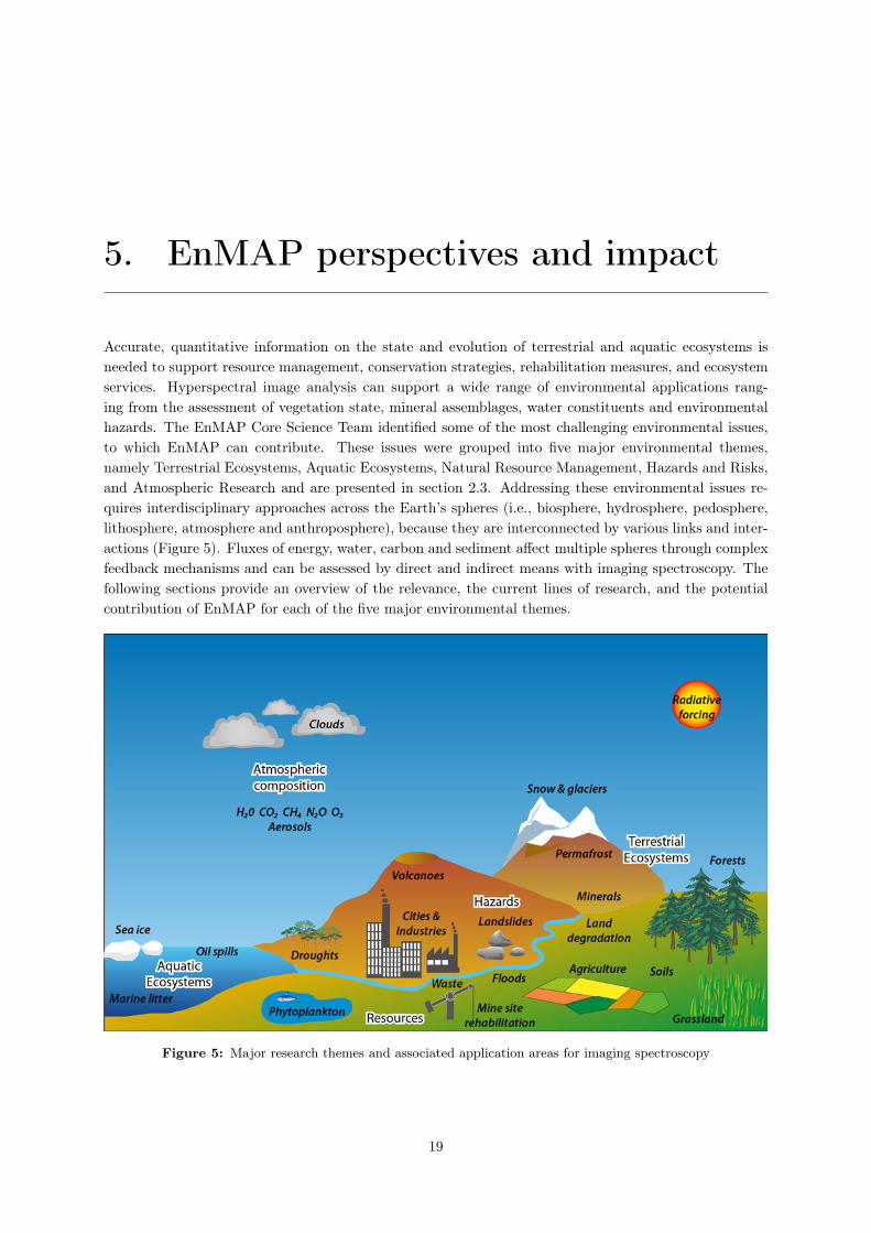
Accurate, quantitative information on the state and evolution of terrestrial and aquatic ecosystems isneeded to support resource management, conservation strategies, rehabilitation measures, and ecosystemservices. Hyperspectral image analysis can support a wide range of environmental applications rang-ing from the assessment of vegetation state, mineral assemblages, water constituents and environmentalhazards. The EnMAP Core Science Team identified some of the most challenging environmental issues,to which EnMAP can contribute. These issues were grouped into five major environmental themes,namely Terrestrial Ecosystems, Aquatic Ecosystems, Natural Resource Management, Hazards and Risks,and Atmospheric Research and are presented in section 2.3. Addressing these environmental issues re-quires interdisciplinary approaches across the Earth’s spheres (i.e., biosphere, hydrosphere, pedosphere,lithosphere, atmosphere and anthroposphere), because they are interconnected by various links and inter-actions (Figure 5). Fluxes of energy, water, carbon and sediment affect multiple spheres through complexfeedback mechanisms and can be assessed by direct and indirect means with imaging spectroscopy. Thefollowing sections provide an overview of the relevance, the current lines of research, and the potentialcontribution of EnMAP for each of the five major environmental themes.
Figure 5: Major research themes and associated application areas for imaging spectroscopy
19

Chapter 5. EnMAP perspectives and impact
5.1 Terrestrial Ecosystems
5.1.1 Natural ecosystems and ecological gradients
Pristine ecosystems on Earth are scarce (Kareiva et al., 2007) and global environmental change impactseven remote areas of our planet. We here refer to ecosystems that are largely untouched by human landuse and unmanaged or protected. Sharp ecosystem boundaries are mostly a characteristic of managedecosystems and therefore transitions or ecological gradients between different natural or natural andmanaged ecosystems are also considered here.
Specifically, monitoring and better characterizing natural or close to natural vegetation is essentialto support sustainability of human-environment systems from local to global scales. Moreover, analysingand monitoring processes related to unmanaged land are crucial to deepen our understanding of indirectglobal environmental impacts and help to improve environmental models.
Quantifying ecosystem characteristics and the services they provide requires using information atthe meso- to macro-scale, which needs to be consistent and reproducible through space and time. Suchinformation can only be obtained by means of remote sensing (Defries et al., 2005). EnMAP data andproducts derived from it will overcome current limitations, particularly in respect to the quantificationof complex processes and gradual changes, which are prevalent in natural ecosystems (Asner et al.,2005). Concepts for the description of heterogeneous vegetated surfaces and floristic composition becomepossible, e.g. the plant functional types concept (Lavorel et al., 2011).
Previous studies made use of field-based or airborne hyperspectral imagery for quantifying biophys-ical parameters of natural vegetation, such as primary production, Leaf Area Index or photosyntheticactivity (Lee et al., 2004; Smith et al., 2002), biomass (Mutanga and Skidmore, 2004; Cho et al., 2007),carbon storage and water fluxes (Fuentes et al., 2006), ecosystem structure (Asner et al., 2005), or veg-etation successional stage (Oldeland et al., 2010). Further uses of hyperspectral imagery have been onsingle species mapping (Cochrane, 2000; Clark et al., 2005) and the monitoring of invasive species (Un-derwood et al., 2003). However, most of these studies are limited to one acquisition per year or less andnone of them could make use of high quality, landscape scale hyperspectral data, as EnMAP will provide.While the relatively coarse spatial resolution of hyperspectral satellite data will add challenges to suchapplications, data quality and availability will open up new pathways for parameter retrieval.
In this sense, high temporal and systematic coverage by hyperspectral satellite systems such asEnMAP will allow for continuous monitoring of natural processes, as demonstrated by pilot studies usingdata from experimental spaceborne systems (Asner et al., 2004; Stagakis et al., 2010), and will thusimprove our understanding of these processes (Ustin et al., 2004). Phenological studies, previously basedon existing platforms (Hoare and Frost , 2004; Fisher et al., 2006), are likely to reveal new insights byimproved information that can be retrieved from high spectral resolution data. These data should befundamental in improving existing carbon emission accounts and monitoring efforts (Numata et al., 2011),necessary to make mechanisms, such as REDD or REDD+, effective.
Physical-based modelling concepts are not advantageous for the work in natural environments be-cause model calibration of such heterogeneously composed vegetated surfaces is too complex. Advancesin statistical and machine learning, however, provide a set of methods that are capable of coupling quali-tative and quantitative analysis without being affected by collinearity effects in contagious datasets. Suchnew developments like self-learning decision trees, partial least square regressions, Gaussian processes orsupport/import vector machines (Breiman, 2001; Helland , 1990; Vapnik , 1998; Zhu and T., 2005) havehigh potential in making best use of the extended information in EnMAP data and allow for describingmentioned processes (e.g. Verrelst et al., 2012; Feilhauer et al., 2010).
Beyond the direct use of such generic algorithms for empirical modelling approaches, the generationof new indices and thematic transformations is of utmost importance. Multi-band indices and non-linear
20
Chapter 5. EnMAP perspectives and impact
transformations may be developed based on insights derived from empirical studies with, for example, anon-linear kernel-based approach. Such developments have to be robust and possibly general. However,in most cases a biome-specific calibration procedure will be required and such calibration will be a keyaspect in algorithm development in near future.
EnMAP imagery will thus be extremely useful for monitoring natural ecosystems and their ser-vices, by allowing the accurate quantification of gradual biophysical parameters, and the description ofheterogeneous landscapes through the estimation of natural composition and pixel fractions of cover.
The following main scientific tasks are related to natural ecosystems:
• Assess ecosystems services, such as the above ground carbon sequestration potential;
• Retrieve biochemical and biophysical parameters as input in ecosystem and species habitat modelsto improve the understanding of ecosystems and ecological processes;
• Assess the spatial pattern of ecosystems and biodiversity distributions from local to global scalesin the context of nature protection legislation such as the European habitats directive;
• Monitor natural or quasi-natural vegetation areas (such as nature protection areas, naturalized,un-used or extensively used areas) to understand causes and driving forces of changes, for example,in the context of land abandonment, forest disturbance or land degradation processes in order tocombat biodiversity loss and promote ecosystem stability (e.g. REDD+);
• Quantify spatial and temporal ecosystem transitions, such as e.g. vegetation succession, habitatheterogeneity, plant or animal community transitions, and assess potential feedback mechanisms;and
• Investigate the effect of climate change and other anthropogenic and non-anthropogenic forces onglobal vegetation gradients.
5.1.2 Forests
Worldwide, forests provide timber and non-timber products as well as numerous environmental goodsand services, such as conservation of biological diversity and climatic control, which are crucial for locallivelihoods (FAO , 2010). However, forests and forested ecosystems are being rapidly depleted and underincreasing pressure due to global warming (Birdsey and Pan, 2011; Peng et al., 2011) and expandinghuman populations and economies (Hansen et al., 2008). Deforestation associated with conversion offorests to agricultural land, legal and illegal timber harvesting and recurrent wildfires are some of themost important processes, which affect forested landscapes (Bond , 2010).
The challenges in forest management are multiscale and intricately linked to society’s needs topreserve multiple forest values and benefit from its products. The pressing need for sustainable forestmanagement aims at combining economic interests with ecologic concerns. In this context, remote sensingdata serve economically oriented assessments and management needs as well as studies of ecologicalprocesses and functions (Franklin, 2001). Applications of remote sensing contributing to sustainable forestmanagement are generally presented in four categories that include classification of forest covertype (i.e.tree species), estimation of forest structure and available resources (i.e. timber volume, height, age, crownclosure), forest change detection and forest modelling. For each category measurable indicators are neededto quantify the effects of management activities and natural phenomena on the sustainability of forestresources. Current research is directed at quantitatively relating remotely sensed spectral information toground-based assessments of structural and physiological aspects of forest condition.
21

Chapter 5. EnMAP perspectives and impact
The future EnMAP satellite can efficiently characterize the spatial distribution of forest ecosystemsand provide an inventory of forest resources. Such inventories typically comprise quantitative attributesrelated to forest species, health, and functioning, including estimates of chlorophyll, nitrogen, lignin andcanopy water content (Goodenough et al., 2003a; Matson et al., 1994; Schlerf et al., 2005, 2010). Quan-tifying such species-specific canopy biochemistry differences is well established to map forest species andecosystems (Goodenough et al., 2003b; Martin et al., 1998). The fusion of hyperspectral data with otherremote sensing data sources like Radar or Lidar offers additional perspectives to estimate forest structure,forest type, biomass, timber volume, tree heights, stem densities, and age classes (Anderson et al., 2008;Dalponte et al., 2008; Huang et al., 2007; Hyde et al., 2006). Furthermore, it is possible to estimate theabove ground carbon stored in the forests, e.g. in the context of REDD (UN Collaborative Initiativeon Reducing Emissions from Deforestation and Forest Degradation, FAO, UNDP, UNEP Framework-Document , 2008), by combining hyperspectral imagery with geographic information, field calibrationsand physiological models (le Maire et al., 2005), as well as texture and object information (Blaschke,2010; Buddenbaum et al., 2005; van der Linden et al., 2007). Thus, imaging spectroscopy offers accurateways of providing needed forestry information as well as the potential for new indicators of vegetationstate and indices of forest biochemistry and functioning.
Reforestation, afforestation, and deforestation rates can be assessed on regional scales (Clark et al.,2011; Goodenough et al., 1998). Such measures are needed for the Kyoto Protocol on greenhouse gasreductions and provide an essential contribution for documenting changes in the forests over time. Pre-vious studies on forest ecosystems emphasized the role of imaging spectroscopy allowing detailed andaccurate retrievals of relevant vegetation properties (Ollinger and Smith, 2005; Schaepman et al., 2004),where the most important vegetation parameters are leaf chlorophyll and nitrogen content, the fractionsof photosynthetically absorbed radiation (fAPAR), canopy water content, annual maximum leaf massper area (LMA), and annual maximum leaf area (LAI) (e.g. le Maire et al., 2008). Finally, EnMAP canestimate changes in forest structure and condition, including above ground carbon stocks at improvedaccuracies.
Important ecological processes in forests include carbon exchange (photosynthesis and respiration),evapotranspiration, and nutrient cycling (Coops et al., 2009; Waring and Running , 2007). To model theseprocesses on a regional to global scale, imaging spectroscopy currently provides accurate local estimatesof forest structural and chemical properties, which serve as required inputs to initialize, calibrate, andvalidate such models (Tenhunen et al., 1998). In the mid-term perspective these models can assistmanagement decisions to mitigate the effects of climate change on a regional scale.
Given the complexity of hyperspectral analysis, expert systems to support the analysis for EnMAPdata have been developed (Goodenough et al., 2012, 2007). Forest reflectance models, as comparedto agricultural models, require much greater attention to forest structure, clumping, shadowing andunderstory effects. Reflectance models ranging from simple approaches like INFORM (Atzberger , 2000)or 4-scale (Chen and Leblanc, 1997) to more complex geometric-optical radiative transfer models likeFRT (Kuusk and Nilson, 2009) or raytracing models like FLIGHT (Gerard and North, 1997) have beendeveloped and validated in order to analyse the complex hyperspectral signal of forests (Foerster et al.,2010). Despite some successful attempts (Combal et al., 2002; Koetz et al., 2004; Schlerf and Atzberger ,2006; White et al., 2000), the inversion of these models is still a challenge and a pressing research issuefor the next years.
EnMAP will be evaluated as a tool for developing spectral indices that will serve as bio-indicatorsof forest condition. Through repetitive sampling of selected forest condition test sites, EnMAP wouldadd the phenological history to the full spectral sampling data to yield effective bio-indicators of forestcondition. EnMAP will provide a capability to compare observations of spectral properties of forests inmany different countries. This is essential in order to develop a consistent tool for monitoring the carbonstate of the world’s forests and their response to climate change. Frequent and broad coverage will
22

Chapter 5. EnMAP perspectives and impact
increase our understanding of the links between pigments, canopy chemistry, stress, and forest type. Forforest inventory programs, hyperspectral data from EnMAP can provide an important sampling systemto ensure precise measurements of indicators for a sustainable development.
Accordingly, the following main scientific tasks are considered important in regard to forest applications:
• Map forest species distributions using hyperspectral, fused and multitemporal datasets, exploringthe potential of advanced classification algorithms, texture and object information, and linkages togeographic databases etc.;
• Estimate forest biomass and above ground carbon;
• Assimilate biochemical and structural forest parameters into process models;
• Enhance and develop invertible vegetation canopy reflectance models for the forest environment,extraction of forest parameters, and forest mensuration, health, and risk assessment;
• Investigate the viability of phenological signatures through indicators of canopy pigments and chem-istry with regard to ecophysiological processes;
• Develop improved optical indices that will serve as bio-indicators of forest condition;
• Develop forest monitoring procedures including multi-temporal and multi-sensor data for the de-tection of changes in forest quality and canopy cover, and
• Create advanced expert systems to improve the efficiency of hyperspectral information extractionwithin the forestry context.
5.1.3 Cryospheric ecosystems
The magnitude of predicted global warming is largest in high latitude and high altitude regions (IPCC ,2007). Retreating glaciers, decreasing sea ice extent, shorter snow cover periods, and accelerated degrada-tion of permafrost areas testify this longstanding trend (e.g. Pritchard et al., 2009; Liston and Hiemstra,2011; Stroeve et al., 2007; Lawrence and Slater , 2005). Complex feedback mechanisms caused by a de-crease in surface albedo imply a wide range of climatic, hydrologic, ecologic, and geomorphic changes inthese regions. Yet, quantifying the state and changes of snow, glaciers, ice caps, sea ice and permafrostis strongly hampered by missing ground observations due to the challenging logistics as a result of theremote and complex terrain. Therefore, satellite observations represent a unique database to track andquantify variations in the cryosphere.
Despite the environmental limitations for optical sensors in the polar regions (i.e. months of polarnight, high cloud coverage, and year-round low solar incidence angle) hyperspectral data provide uniqueinformation on biogeochemical parameters that are important to model energy, water, sediment, andcarbon fluxes. Therefore, hyperspectral remote sensing offers the great potential to measure key diagnosticparameters that verify changes in the cryosphere at landscape scales.
Permafrost
Permafrost covers about 25% of the northern hemispheric land area and hence represents one of the largestcomponents of the Arctic cryosphere. Arctic environments maintain important ecosystems with uniqueplant communities, which are particularly sensitive and responsive to climatic changes. Field observationsof the active layer (top layer of soil that thaws during the summer) and the permafrost dating back to the1970s show a continuously warming trend with a high spatial variability in warming rates that depend
23

Chapter 5. EnMAP perspectives and impact
on ice content and absolute ground temperatures (Smith et al., 2010; Romanovsky et al., 2010). Large-scale permafrost degradation may provoke feedbacks such as activation of the soil carbon pool and anorthward expansion of shrubs and forests (Lawrence and Slater , 2005). Increased permafrost knowledgeis particularly important for the design and maintenance of infrastructure in permafrost environments andfor designing effective adaptation strategies for the local communities under warmer climatic conditions(Romanovsky et al., 2010).
Permafrost is an underground thermal phenomenon, which cannot be directly observed by opticalremote sensing. However, there is a large number of surface indicators suited for hyperspectral remotesensing applications, such as changes in vegetation biomass and communities, surface morphology, hy-drology, and aquatic ecosystems. In particular, the discrimination of different vegetation types andbiophysical variables (e.g., leaf area index or biomass) is of great interest in tundra/permafrost research(Rees et al., 2003; Laidler and Treitz , 2003; Hope et al., 2003). Similarly, robust data on the proportionsof soil, nonphotosynthetic vegetation and green vegetation in various landscapes are needed (Warner andAsada, 2006). For example, Muster et al. (2012) used CHRIS and other optical remote sensing data toinvestigate the water body area and the moisture regime for detailed process studies of energy and waterfluxes in the Lena Delta of Siberia. Detailed spatial information on surface variables, such as vegeta-tion biomass, plant functional types, the moisture regime, the insulating moss layer, the surface waterratio, the dissolved organic carbon and particulate matter concentration, is crucial to detect the state ofpermafrost and to model thermal, hydrological, and carbon fluxes.
Snow & Ice
Characterization of snow-covered areas and glaciers is critical for understanding Earth’s hydrology, cli-matology and ecology because of their significant effect on the energy balance at the land-atmosphereboundary and their importance as fresh water sources. However, detailed ground-based measurements ofsnow and glacial properties are scarce due to the remoteness and complex terrain of most snow-coveredareas. Imaging spectroscopy can be used to retrieve key snow parameters, such as snow covered area,albedo, grain size, snow impurities, and liquid water content in the near-surface layer, in order to modeltheir effects on the regional water and energy cycle (Dozier and Painter , 2004).
Snow evolves after its deposition. Snow albedo and snowmelt are directly linked to the growth ofgrain size (Warren and Wiscombe, 1980). The broadband reflectance decreases dramatically, especiallyin the near infrared range, as the snow grains evolve. In the same way liquid water inclusions of meltingsnow yield albedo reductions, because liquid water in snow caused the grains to form clusters (Colbeck ,1979). Similarly, snow contaminants such as dust, algae, and soot degrade snow reflectance significantly,especially in the visible spectrum by adsorption of incoming radiation and at longer wavelength by in-creases in grain size through local microscale metamorphism (Dozier et al., 2009). Repeated hyperspectralmeasurements of snow cover enable us to quantify the evolution of broadband albedo by accounting forvarious effects like grain size and snow contaminants. In addition, spectral mixture analysis enables map-ping surface constituents at subpixel resolution in order to accurately represent the spatial distributionof snow (Nolin et al., 1993). Accurate measurements of these physical snow properties (i.e. fractionalsnow covered area and snow albedo) are prerequisites to drive distributed hydrological models in orderto quantify timing and magnitude of snowmelt runoff and its source areas.
Future snow and ice research will benefit from a synergistic data collection that combines finespectral and spatial resolution (EnMAP) with a broad swath and daily coverage of the whole Earth(MODIS, Sentinel 3, VIIRS). Envisioned applications include regular tests of medium spatial resolutiondata with EnMAP and data assimilations to improve models of snow cover and albedo evolution by anincreased temporal and spatial resolution. Earth observing imaging spectrometers have large potential tocapture seasonal variations in snow cover and albedo with high accuracy. Further information that may
24

Chapter 5. EnMAP perspectives and impact
be retrieved from EnMAP data include snow grain size, liquid water near the surface and snow impuritiescontent derived from dust, soot, or organic content. Some of the remaining challenges are to improvesnow mapping in forests, adapt to angular variability in the signal, further investigate the measurementand consequences of absorbing impurities in snow. This information from both operational sensors andimaging spectrometers need to be incorporated into hydrologic models that, together with advances inmodelling and remote sensing, would better characterize the fluxes and reservoirs in snow covered areas(Dozier et al., 2009).
Imaging spectroscopy of sea ice and glaciers can similarly contribute to an improved understanding ofsurface energy fluxes and mass flux quantifications. For example, the extent of melt ponds on sea ice andglaciers can be quantified and their resulting impact on the surface albedo. Furthermore, the extensiveglacial debris cover, which characterizes most mountain glaciers, can be analysed by spectroscopic meansto decipher their origin and to improve glacial mapping as well as our understanding of glacial ablationand kinematics (Casey et al., 2012).
The following main scientific tasks are related to cryospheric ecosystems:
• Assess the state and changes in vegetation biomass, hydrology, and surface morphology in per-mafrost landscapes;
• Discriminate different permafrost vegetation communities and plant functional types;
• Develop and improve new hyperspectral approaches to retrieve snow properties (e.g., albedo, grainsize and near-surface liquid water, mineral and organic contaminants) and spatial snow cover dis-tribution;
• Establish multi-seasonal time series of snow parameters to improve regional hydrologic models;
• Analyse the effect of snow impurities on variations in snow melt timing and magnitude; and
• Explore synergies to multispectral sensors with varying spatial scales to improve snow mapping inforests and adapt to angular variability.
5.1.4 Agricultural land
Limited land resources, increasing land degradation, rising population numbers, an increasingly meat-prone diet, a growing demand for biofuels, and on-going climatic change coupled with more frequentextreme events cause substantial land use conflicts between food- and energy production versus ecosystemservices including biodiversity conservation. To sustain the benefits of natural ecosystems, a growingdemand for agricultural commodities can only be met by sustainable increases in land productivity.However, global scale studies highlight that large appropriation of land resources contrast low efficienciesin land management (e.g. water use) (Haberl et al., 2007; Kijne et al., 2009). The challenge to reverse thisglobal trend involves a wide range of land management aspects, including the selection of suitable plantsand cultivars, water productivity, organic farming, fertilizer and pesticide management, soil conservation,and irrigation. Because of the spatial variability in climate, soils and topography, as well as societalaspects like culture, education, technology and markets, agricultural management relies critically onspatial data to support management decisions. Therefore, modern farming practices try to incorporatethe identification, analysis, and management of spatial and temporal variability within regions and fieldsfor optimum profitability, sustainability, and protection of the environment.
Moran et al. (1997) identified key areas where remote sensing can provide critical spatial informationfor agricultural management. These aspects include the mapping of crop yield and biomass as well as themonitoring of seasonally and spatially variable soil and crop characteristics. Since this early assessment,
25
Chapter 5. EnMAP perspectives and impact
our understanding of farming related land heterogeneity management has progressed towards a site-specific management to support sustainable productivity. This method for agricultural managementincludes early detection of infections, as well as water and fertilizer deficits, monitoring of ecologicalintensification of extensive agriculture as well as ecological extensification of intensive agriculture, and theidentification and evaluation of new land reserves where agriculture could be established due to climaticchanges. These land management practices lead to a new demand for more complex and integrated globalinformation, e.g. in land evaluation, site and plant specific yield gap (the difference between potentialand actual yield) determination, fertilizer intensity monitoring as well as determination of seeding datesand spatially distributed plant phenology.
Hyperspectral instruments, providing agricultural information more accurately and in more detailthan existing operational multispectral sensors, can substantially support farming decisions (Staenz et al.,1998). In addition, hyperspectral instruments offer more spatially distributed, in-depth information thanprovided by conventional statistical regression analysis between laborious ground-truth measurements ofvegetation parameters and simple spectral indices. A more thorough approach is to fully exploit thecomplete spectral information content by invertible vegetation canopy reflectance models. These modelsinfer biochemical/biophysical parameters, such as chlorophyll and water content, from continuous canopyspectral reflectance signatures and have previously been applied to field crops and grasslands (Bach et al.,2003, 2011; Jacquemoud et al., 2000; Migdall et al., 2009, 2010; Verhoef and Bach, 2003). The parametersthat control productivity and health of vegetation can be estimated through model inversion using remoteoptical measurements such as retrieved from EnMAP.
Recent studies have shown that the following set of crop parameters relevant for agricultural pro-duction can be retrieved from hyperspectral data:
• Leaf area index (LAI) describing the size of the producing layer (Weiss et al., 2001);
• Absorbed photosynthetic active radiation (APAR) providing the amount of absorbed energy usablefor production (Weiss et al., 2010);
• Chlorophyll content as the chemical actor for photosynthesis, which is dependent on nitrogen ap-plication (Haboudane et al., 2002; Oppelt and Mauser , 2003);
• Water content as indicator for water status of a specific crop type and its maturity (Ceccato et al.,2001; Champagne et al., 2003);
• Plant density as indicator of disease sensitivity (Larsolle and Hamid Muhammed , 2007);
• Plant pigments such as carotinoids and anthocyanins as indicators of adaptation of the canopy tovarying light conditions (Blackburn, 2007).
Assimilation of these and additional remotely sensed plant parameters, like phenology and seeding date,into agro-ecological models allows to explicitly simulate crop growth for each pixel based on the plantparameters retrieved from hyperspectral remote sensing data. This approach provides site-specific in-formation on key farming parameters like biomass, plant height, crop yield, nitrogen or phosphorusdeficit and/or uptake, which are not directly observable with remote sensing. Furthermore, time seriesof remotely sensed plant parameters account for spatiotemporal heterogeneity in agricultural productionmodels, which can also be used to explore the suitability of different management options (Hank et al.,2012).
From the large number of existing crop growth models, the CERES family (Ritchie and Otter , 1985)is one of the most prominent models, which relies on statistical relationships between environmental vari-ables and plant growth and development. PROMET-V (Schneider and Mauser , 2001) is an advancementof such an agricultural model towards spatially distributed simulations that integrate remote sensing data.
26
Chapter 5. EnMAP perspectives and impact
A further development towards process understanding is achieved by dynamic vegetation models, whichsimulate plant growth on the basis of eco-physiological processes and feedbacks during the photosynthesisand respiration process.
Currently, the most realistic representation of vegetation dynamics in regional agro-ecological modelsas well as regional to global ecosystem and Earth system models is based on the combination of dynamicvegetation models, agricultural management models (e.g. PROMET (Hank , 2008), LPJ-mL (Bondeauet al., 2007)), and appropriate canopy models that simulate the distribution of assimilates among theplant constituents (i.e. roots, stem, leaves) in order to allow for a realistic representation of complexcanopy layers. Recent studies have shown that the proposed data assimilation approach is viable andprovides reasonable results (Bach et al., 2003; Weiss et al., 2001; Hank et al., 2012). Nevertheless, furtherresearch and development is needed to improve models, in particular with regard to process representationand accuracy. In addition, various data assimilation methods should be tested under a broad range offarming conditions, especially in regions with low-efficiency farming systems, different crop (e.g. cassava,sorghum, groundnut) and energy plants (e.g. sugar cane, oil palm, jatropha), different stresses (e.g. water,fertilizer, temperature), irrigated agriculture, and mixed silvi-agricultural systems in order to reach anoperational stage of such coupled model systems.
Besides further improvements in modelling approaches, sophisticated agricultural applications needto be based on frequently available hyperspectral imagery with high data quality standards. Based on theknowledge already gained in numerous studies with airborne sensors, EnMAP will offer hyperspectral datain a suitable spatial and temporal resolution to approach the next major scientific step from regressionanalysis to a mechanistic process representation.
The following major scientific and application tasks have been identified in agriculture:
• Develop and improve accurate, robust and reliable crop parameter retrieval methodologies basedon inversion of improved canopy reflectance models using imaging spectroscopy data (retrieval ofcrop type, LAI, APAR, chlorophyll content, plant water content, canopy geometrical structure);
• Develop and improve methods for quantitative mapping of soil parameters, also taking the spectralsignal of vegetation into account;
• Develop and improve approaches to derive complex canopy parameters, e.g. crop phenology, man-agement intensity or yield gap, from hyperspectral remote sensing data, in conjunction with ancillaryremote sensing data.
• Develop operational methodologies for yield and biomass estimation and forecasting based on En-MAP and ancillary data.
• Map crop species distribution using hyperspectral-temporal information content;
• Distinguish crop stressors like nitrogen deficiency, crop disease, insect infestation, water stress, andchlorosis; and
• Develop and improve approaches to assimilate remote sensing derived spatial distributions of veg-etation and soil parameters into dynamic agro-ecological models.
5.1.5 Urban areas
Over the past 50 years, anthropogenic ecosystem changes were more rapid and extensive than in anycomparable period of time in history (MEA, 2005). The world currently experiences rapid urbanizationand an increase in the number of megacities, particularly in developing countries. According to the
27
Chapter 5. EnMAP perspectives and impact
United Nations Development Program, urban population growth will continue to rise substantially overthe next several decades (UN , 2006). The (often uncontrolled) process of urbanization always results inchanges in land use and cover and causes serious problems such as environmental pollutions, destruction ofecosystems, waste disposal and others. Moreover, urbanization and related changes in lifestyle increase theper capita demand for energy, goods and services (Meyerson et al., 2007). Land conversions, introducedby urban consumption patterns, have regional consequences for the biophysical system that may leadto global consequences (Sanchez-Rodriguez et al., 2005). Thus, there is a critical need to map urbanland cover composition and monitor urban growth. Remote sensing techniques are widely used to studyurban environments. However, hyperspectral applications are comparably scarce (Xu and Gong , 2007;Cavalli et al., 2008; Weng et al., 2008), which may, to a great extent, be explained by the spectraland structural complexity of urban areas (Small , 2003, 2001; van der Linden and Hostert , 2009) andto a limited availability of appropriate sensors covering the full reflective wavelength range. EnMAPhyperspectral data of medium spatial resolution will open up new opportunities to describe and monitorland cover composition in urban areas and along urban-suburban gradients assisting in the understandingof the dynamics of global urbanization (Heldens et al., 2011).
Classification schemes for urban areas are generally influenced by the spatial scale of analysis andthe scope of related studies (e.g. Heiden et al., 2007; Herold et al., 2004). Research is needed to determinethe most suitable classification scheme for EnMAP. Given the 30 m ground sampling distance of EnMAPurban mapping will often require a quantification of the sub-pixel land cover composition. For these typesof analyses, techniques such as spectral unmixing or regression modelling that are capable of dealingwith the spectral variety of urban surfaces have to be developed (Roessner et al., 2001; Franke et al.,2009). For both qualitative and quantitative analyses of urban areas the implementation of referencespectral libraries is essential (Heldens et al., 2011), yet poses a challenging step that requires extensivecollaboration between international research groups (Hueni et al., 2009; Rasaiah et al., 2011). Thecombination of medium spatial resolution and high spectral information content requires new conceptsfor the description of land cover composition. While the occurrences of spectrally pure surface materialsare rare, urban spectral mixtures contain compositional information that might be characteristic forcertain urban structures such as inner city centres or commercial areas. Recent studies that focused onplant species variations used compositional variation to extract major vegetation gradients (Schmidtleinand Sassin, 2004; Feilhauer et al., 2011). Applying such concepts to urban areas could account for thespectral and spatial information content of EnMAP data of urban areas.
One essential application with regard to urban planning is reliable mapping of imperviousness. Here,approaches that combine qualitative and quantitative analyses appear most suited to make full use ofthe additional information from EnMAP data. This additional information will help make approachesbased on the V-I-S concept (Ridd , 1995; Wu and Murray , 2003; Lu and Weng , 2006) more reliable or helpto extend such models by additionally differentiating built-up and non-built-up areas. Reliable surfacematerial indicators are needed for applications such as urban climate studies. In this context, fusion ofspectral and thermal data (at the feature or knowledge level) may reveal the relationship between thermalpatterns, urban surface materials, and urban structure and thus, helps to understand their influences onthe urban climate (Oke, 1988). Such data fusion studies have already been carried out at local scale withairborne thermal and hyperspectral data (e.g. Xu et al., 2008). Novel fusion techniques combining futureEnMAP data with thermal sensors (e.g., ASTER, HyspIRI) can open up new opportunities for urbanclimate studies on larger scales. Another challenging task is the combined analysis of hyperspectraldata and high-resolution remote sensing data, which enables a detailed analysis of urban structurescombined with surface material information. In this context, image data fusion (Zhang , 2010) is apromising technique to retrieve further information from EnMAP data. Yet, methodological gaps existfor spatial upscaling techniques that preserve spectral information content. Overall, the synergistic use ofhyperspectral-, thermal-, and optical data with advanced data analysis techniques may result in enhanced
28

Chapter 5. EnMAP perspectives and impact
socioeconomic and environmental indicators to model urban dynamics and their social and environmentalconsequences.
Accordingly, main scientific tasks related to urban areas include:
• Map and monitor urbanization and its dynamics on a global scale;
• Implement a comprehensive spectral library to analyse urban land cover based on EnMAP data;
• Develop and improving classification algorithms to map urban land cover (including classes thatare spectrally ambiguous in multispectral data) at the spatial resolution of EnMAP;
• Develop algorithms for quantitative analysis of urban land cover composition at the spatial resolu-tion of EnMAP with regard to mixed pixel problems and rare pure endmember availability;
• Investigate of new concepts for the information extraction based on compositional information ofspectral mixtures;
• Apply the V-I-S concept to monitor impervious surface fractions, e.g. in context of urban climatestudies;
• Support urban climate studies by hyperspectral data; and
• Map the abundance of hazardous materials such as asbestos, e.g. in the context of risk analyses.
5.2 Aquatic Ecosystems
5.2.1 Coastal and inland water
Coastal and inland water bodies are vital for recreation, food supply, commerce and human health, andthey also support habitats for a large floral and faunal diversity. Currently, these ecosystems experiencehigh pressure from increasing social and economic human activities as well as climate change. As sinks forpollutants, coastal and freshwater ecosystems are among the most sensitive indicators of environmentalimpacts related to human activities (UNEP , 2012). For example, a major global ecological problem isthe increasing eutrophication and pollution of coastal and inland water bodies caused by fluvially trans-ported substances such as phosphate and nitrogen compounds, which derive from intensified agriculturaland industrial activities. Monitoring and managing the water quality of coastal and inland habitats isnecessary as they are vital to many kinds of utilization, including urbanisation, tourism, transportation,industry, fish farming and drinking water supply. According to the EU Water Framework directive 2000,specified biological, hydro-morphological and physico-chemical parameters of water bodies have to bemonitored on a regular basis.
A major advantage of hyperspectral data covering coastal and shallow freshwater bodies is the abilityto spectrally unmix various in-column optical constituents and the sea floor or lake bottom (Carder et al.,1993; Goetz , 2011). The advanced spectral resolution of EnMAP in the visible and near-infrared regionwill allow the assessment of water constituents including phytoplankton pigments, suspended matter,dissolved organic matter, dissolved organic carbon concentration, and water transparency. Moreover,phytoplankton taxonomic groups can be identified, which provide indications for the occurrence of harmfulalgal blooms (Bracher et al., 2009). Chlorophyll-a concentration is widely used as an indicator of algalbiomass that depends upon nitrogen and phosphate availability in the water bodies (Carlson and Simpson,1996; Kamarainen et al., 2009). Water transparency is a widely used indicator of the trophic state, whichis influenced by the abundance of organic and inorganic suspended particulate and dissolved matter
29

Chapter 5. EnMAP perspectives and impact
(Kirk , 1994). Several researchers have developed algorithms to quantify various parameters, such aschlorophyll-a, humic substances, suspended matter, yellow substances, and water transparency (Giardinoet al., 2007; Kallio et al., 2001; Schiller and Doerffer , 1999; Thiemann and Kaufmann, 2000, 2002).EnMAP can make use of these standards for detailed observations of coastal zones and inland waters,while sensors such as MERIS, MODIS and SeaWIFS are designed for ocean applications with frequentobservations at coarser spatial resolutions. Algorithms for coastal and inland water constituents withdifferent phytoplankton, particulate and dissolved matter composition will be adapted and improved forEnMAP to provide water quality data at a higher spatial resolution. Water quality assessment serves bothmonitoring of freshwater security and the still increasing importance of aquaculturally used coastal andinland water bodies. Moreover, water quality assessment is crucial for the monitoring and managementof endangered ecosystems such as coral reefs, seagrass meadows or mangrove forests (Bell et al., 2008;Landvelde and Prins, 2007).
EnMAP data will not only offer more frequent observations of in-column constituents, but willprovide frequent information about the type and status of the sea floor substrate and its changes. Watercolumn correction approaches using hyperspectral data allow the identification of bottom vegetation typesand, if regularly monitored, the observation of sedimentation dynamics (Deronde et al. 2004) as well asshort- and long-term changes in species distribution and structure (Vahtmaee et al., 2011). Quantitativeanalyses of coastal benthic communities enable the investigation of net primary production (Dierssenet al., 2010). Moreover, many benthic species act as environmental indicators. Their frequent monitoringtherefore enables an estimate of the state of coastal marine environments and provides evidence forenvironmental changes (Phinn et al., 2003; Vahtmaee et al., 2006). In this context, the fusion of EnMAPdata and satellite data with a high geometric resolution (e.g. Worldview, GeoEye) offers the potentialto pinpoint heterogeneously distributed vegetation and sediment patches. The monitoring of benthicvegetation can support integrated coastal zone management when species of certain genera (e.g. Ulva,Laminaria, seegrasses) are grown as a food supply for humans or aquaculture of marine animals (Andersonet al., 2007; Radiarta et al., 2011). The fusion with spatially high-resolution data also offers the potentialto monitor frequently invasive benthic and emergent species (Albright and Ode, 2011; Forrest et al., 2012).
Coastal ecosystems are highly productive and store large amounts of carbon (Cole et al., 2007;Pidgeon, 2009). The distribution and dynamics of organic carbon in the vegetation, in combinationwith dissolved organic matter, are important in understanding regional and global carbon cycles. In thiscontext, the EnMAP data provide efficient means to characterize the role of coastal and inland waterbodies in carbon uptake and release.
Coastal and freshwater ecosystem management involves modelling and monitoring, which require areliable information base and robust analytical techniques. Conventional mapping methods are logisti-cally constrained, while airborne campaigns are cost intensive and often are limited to a few acquisitiondates. The EnMAP satellite will enable a repeatable quantitative monitoring of the water-related en-vironmental parameters mentioned above. The combination of hyperspectral data with ecological orhydrological models, geographic information systems and in-situ measurements allows the developmentof advanced integrated management plans for coastal zones and catchments characterized by inland wa-ter bodies, wetlands or reservoirs (Yang , 2009; Radiarta et al., 2011). The fusion of hyperspectral datawith thermal infrared data offers additional perspectives to the analysis of the trophic state of coastal orfreshwater ecosystems. A combination of EnMAP derived bathymetry with RADAR, LIDAR or Laser-scan data can be useful to derive underwater topography and morpho-dynamics of shallow water areas(Pleskachevsky et al., 2011). Thus, imaging spectroscopy enables an accurate estimation of water qualityand sea floor parameters. Moreover, it offers the potential for new and complementary indicators for thecharacterization of the state of coastal and inland water bodies.
Accordingly, the following main scientific tasks are related to coastal and inland water body applications:
30

Chapter 5. EnMAP perspectives and impact
• Improve the identification of different substances by their spectral characteristics, such as improvedchlorophyll quantification, the differentiation between ecological important phytoplankton groups,and dissolved organic compounds;
• Enhance the identification of different fractions of suspended mineral and organic particles;
• Monitor the spatio-temporal dynamics and structure of shallow sea/lake bottom substrate (vegeta-tion and sediment);
• Monitor the distribution patterns of invasive submersed and emergent algae;
• Monitor the variety of algal species/genera in space and time as a bio-indicator of coastal andfreshwater ecology;
• Monitor and taxonomically identify (potentially toxic) algal and phytoplankton blooms in eutroph-icated coastal and inland waters;
• Estimate processes such as primary production in inland and coastal waters and suspended mattertransport and its impact on coastal ecosystems;
• Monitor the distribution of sediments in tidal flats, wetlands, and mangrove forests; and
• Monitor coastal erosion and changes in coastal morphology.
5.2.2 Oceans
Oceans cover about 71% of the Earth’s surface. Ocean currents greatly affect the Earth’s climate bytransferring heat from the tropics to the polar regions and influencing inland precipitation patterns.In general, oceans host a vast resource of marine life and play a vital part in the global carbon andoxygen cycle. For example, oceanic phytoplankton represent only 2% of the global plant biomass but isresponsible for about 50 % of the global primary production (Berger , 1989).
Remote sensing enables us to study the upper ocean layer on various spatial scales to identifysurface processes and to quantify characteristic parameters, such as phytoplankton biomass, sedimentdistributions, salinity, and surface temperatures. The first optical sensor built to study specificallythe oceans, the Coastal Zone Color Scanner (CZCS), was launched in 1978 and paved the way forseveral subsequent instruments like SeaWIFS, MERIS, and MODIS and will be continued by OLCI inthe forthcoming Sentinel series. All these globally covering multispectral instruments are optimised toanalyse the open ocean, which can optically be characterised by only one parameter, the chlorophyllcontent (case 1 water). Since the advent of MERIS we are also able to resolve properties of opticallymore complex coastal waters (case 2) like chlorophyll, suspended sediments and chromophoric dissolvedmaterial (IOCCG , 2000). EnMAP’s strength is based on its higher spectral and spatial resolution.These characteristics are important to resolve coastal regions with highly structured geographic features,infrastructures like rigs or offshore windfarms, and shallow waters with a high variability like lagoons,estuaries and wadden seas. For example, off-shore windfarms may affect sediment resuspension and mayalter the biotic communities, which can be observed with hyperspectral imagery. Furthermore, it is ofgreat interest to detect and analyse marine processes involving small-scale patterns and structures. Anunresolved research topic in the marine community focuses on the detection of increased phytoplanktonoccurrences along eddy structures. Another open question that can be addressed with EnMAP concernsthe dynamics of cyanobacteria blooms that develop along eddies and their linkage to the upwelling ofnutrients along oceanic frontal and mixing zones.
The following main scientific tasks are related to ocean applications:
31

Chapter 5. EnMAP perspectives and impact
• Monitor the impact of off-shore windfarms on the bottom substrate and biotic communities; and
• Detect phytoplankton along small-scale eddy structures and quantify their dynamics.
5.3 Natural Resource Management
Natural resources are natural assets occurring in nature that can be used for economic production orconsumption. Management of natural resources comprise their exploration, monitoring, and sustainableutilisation. Because natural resources form the basis for economic growth, they are of major interest forgovernments and industries. In this section, natural resources refer to the availability of abiotic resourcesincluding minerals, soils, and fossil fuels whereas biotic resources are mainly addressed in the previoussection on “terrestrial and aquatic ecosystems” (see section 5.1 and 5.2). Imaging spectroscopy has provento be an effective tool to detect, monitor, and manage natural resources. Current research focuses on theassessment of mineral deposits (e.g. Clark et al., 2003), the management of mining impacts (e.g. Swayzeet al., 2000), and the deduction of soil properties (e.g. Ben-Dor et al., 2009). Because most presentstudies are based on airborne hyperspectral imagery, EnMAP holds a considerable potential to expandlithospheric investigations and to monitor seasonal or event-based pedologic changes.
5.3.1 Resource investigations
Mineral mapping
Minerals are essential to an industrialized society. This particular interest in detecting mineral com-positions has been the most significant driver in the development of spectroscopy (Schaepman et al.,2009). Spectra of minerals exhibit several diagnostic absorption features mainly due to the presenceor absence of transition metal ions (e.g. iron, chromium, cobalt and nickel) and molecular bonds (e.g.Fe-OH and Mg-OH in amphiboles, Al-OH in clay minerals, CO3 in calcium carbonates). These specificabsorption features facilitate regional mineral mapping based on imaging spectroscopy (van der Meeret al., 2012; Clark et al., 1990). Besides the mineral mining interest, mineral mapping can provide a bet-ter understanding of weathering, mineralization, hydrothermal alteration, and other geologic processes(Clark et al., 2003; Kaufmann et al., 1999). Detectable indicator minerals, such as kaolinite, dickite,alunite, sericite, chlorite and epidote, are commonly found in hydrothermal alteration systems that maycontain deposits of economically valuable minerals, such as gold, silver and copper, to name a few. Inthis context, the detection and assessment of rare earth elements deposits are of greatest interest for bothpolitical relations and the global economy. In specific cases, subtle variations in chlorophyll concentrationof homogeneous canopies may indicate heavy metal concentrations in the underground (Collins et al.,1983). In addition to mineralogical investigations, lithospheric research includes the mapping of volcanoesand their plume composition (Carn et al., 2005; Guinness et al., 2007; Spinetti et al., 2008).
Soil properties
Hyperspectral data as provided by the EnMAP satellite will hold considerable potential to characterizethe pedosphere by identifying soil properties and their changes in time. In view of limited arable land areaand rising population numbers, the emerging field of precision farming is receiving increased attention.Supported by imaging spectroscopy soil conditions can be assessed before, during, and after the growingseason. In this way, farmers can better evaluate critical needs such as irrigation, nutrient supply, andcultivation to gain increased agricultural yields (Dematte et al., 2000).
Soils are complex dynamic systems, which are formed and developed as a result of the combinedeffects of climate and biotic activities, and modified by topography. Soil development that can be either
32

Chapter 5. EnMAP perspectives and impact
progressive or regressive with time modifies the chemical, physical, and mineralogical properties of soilsurfaces to produce distinct spectral features that can be detected using high-resolution reflectance spectra(Leone and Sommer , 2000). In particular, the amount of organic matter and iron content, particle sizedistribution, clay mineralogy, water content, soil contamination, cation exchange capacity and calciumcarbonate content, can be determined with imaging spectroscopy (Ben-Dor et al., 2009).
Petroleum detection
Petroleum, or crude oil, consists of a complex mixture of hydrocarbons and other liquid organic com-pounds. Over the past decades, these hydrocarbons have been the primary energy source, which con-tributed significantly to technological and industrial advances. In recent years, there has been a growingdemand for environmental monitoring, associated with the advance of petroleum exploration at deepoffshore waters and oil sand extractions in pristine ecosystems. Imaging spectroscopy can be used todetect oil discharges on the Earth surface, which is of environmental concern and economical interest(Lammoglia and de Souza Filho, 2011). Oil seepages may occur naturally within onshore or offshorebasins or result from leaks and spills during the extraction, transportation, storage, and utilization ofpetroleum. Oil pools and tar deposits can often be directly detected, whereas micro-seepages may giverise to vegetation stress or cause geochemical alterations in soil and rocks, which can be studied indirectlyusing hyperspectral sensors (van der Meer et al., 2002).
Spectral characteristics of hydrocarbons are linked to their chemical composition, which can beused to distinguish various oil types such as crude oil, emulsified oil, and oil on ocean water (Horig et al.,2001; Lammoglia and de Souza Filho, 2011). For example, hyperspectral reflectance spectra from soilsamples have been used to model the total bitumen content in Canadian oil sands (Lyder et al., 2010;Rivard et al., 2010). However, in marine environments the oil type and the layer thickness are critical tothe applicability of optical remote sensing for natural oil slick detection and identification (Wettle et al.,2009).
The following main scientific tasks are related to the natural resource management:
• Develop algorithms and expert systems for mineralogical mapping with emphasis on alterationzones and index minerals of metamorphic zonations;
• Analyse the capability of hyperspectral data for the detection of rare earth minerals based ondifferent globally distributed sites;
• Develop new algorithms and models for non-linear, weighted unmixing and mineral quantificationapproaches;
• Investigate the effects of mineral-induced stress on the spectral signature of dense vegetationcanopies to establish a link between vegetation stress and specific minerals;
• Quantitatively estimate the influence of external (weathering crusts, lithobionts) and internal (or-ganic matter, opaque accessory minerals) parameters on the spectral signature of rocks and soils –creation of pedo-transfer functions;
• Calibrate remote sensing-based soil condition indices against soil reference samples to better linkspectral parameters with soil development models;
• Retrieve soil properties, such as organic matter and iron content, particle size distribution, claymineralogy, water content, soil contamination, cation exchange capacity and calcium carbonatecontent to analyse status and changes of soils; and
• Develop methods to optimize oil extraction in order to improve ecosystem stability.
33
Chapter 5. EnMAP perspectives and impact
5.3.2 Environmental rehabilitation
The extraction of natural resources is frequently associated with environmental degradation due to thedispersion of potentially toxic substances. For example, numerous abandoned mines (e.g. open pitcoal, copper and gold mines) have left an environmental legacy of acidic drainage and toxic metals indownstream watersheds, with adverse effects to human and ecosystem health (Swayze et al., 2000). Acidmine drainage derives from an enhanced sulfide hydro-oxidation process due to the increased effectivesurface of crushed and milled rocks during the mining process. Sulfuric acid enters the food chain throughcontaminated soils and water, which can ultimately result in the collapse of wetlands (McCarthy et al.,2007) and the decline of ecosystems (Wepener et al., 2011). Imaging spectroscopy can effectively identifycontaminations and determine its sources and downstream impacts on the water cycle and on vegetationhealth (Clark et al., 2003). Hyperspectral mapping of areas affected by acid mine drainage has acceleratedthe site cleanup and saved millions of dollars in cleanup costs (EPA, 1998).
Based on an improved understanding of mining related environmental impacts many countriesstrengthened legislation to enforce environmental protection and to implement rehabilitation measures(MMSD , 2002). In this context imaging spectroscopy represents a comprehensive monitoring tool toassess the mining related environmental impacts and to monitor the progress of ecosystems restoration.In the event of oil spills, as happened in the Gulf of Mexico after the Deepwater Horizon explosion,imaging spectroscopy can accurately identify petroleum and discriminate it from terrestrial backgrounds(e.g. Allen and Krekeler , 2011). Therefore, EnMAP has the potential to become an efficient operationaltool to monitor both the effects of environmental pollution and the progress made in the rehabilitationof affected sites.
The following main scientific tasks are related to environmental remediation:
• Develop geospatial tools and integration techniques for sustainable mine site management;
• Detect, quantify, and model the short- and long-term environmental changes caused by miningactivities;
• Develop algorithms to automatically detect mine waste areas; and
• Assess and quantify the success of remediation strategies.
5.4 Hazards and Risks
With growing population and infrastructure the world’s exposure to natural hazards is increasing (Nelle-mann et al., 2008). In particular, coastal areas record the strongest increase in population growthconcurrently with an increasing exposure to floods, cyclones and tidal waves. Natural hazards encompassa wide range of phenomena that range from geologic and climatic hazards to fires and diseases. Thesehazards occur on different timescales (e.g. earthquakes and droughts) and affect different spatial scales(e.g. landslides and geomagnetic storms).
Many natural occurring phenomena are growing to natural hazards once we are faced with theirextremes. Thus, some topics described in this section are closely linked to other applications and researchtopics (e.g. algae blooms, soil contamination) and can also be synergistically adjusted to the needs ofhazards and risks management. The specific demand for disaster management is described in the followingsection.
34
Chapter 5. EnMAP perspectives and impact
5.4.1 Disaster management
In case of a natural disaster the crisis management is described by the crisis cycle: starting with the(1) urgent crisis, followed by the phases of (2) emergency relief, (3) recovery, (4) reconstruction, (5) riskanalysis, and (6) preparedness and alertness before closing the cycle with the next crisis. Most phasesoffer diverse opportunities for imaging spectroscopy to contribute to an improved and comprehensivecrisis management.
In general, crisis information is needed at different stages before and after a disaster event withvarying degrees of urgency. During the emergency relief phase crisis information is needed to minimizeloss and damage. Rapid mapping based on hyperspectral data requires a high level of readily implementedand computationally efficient algorithms and procedures. Due to the high information content, given thelarge number of spectral bands, an operational use in the case of emergency has to be defined, tested andaccurately described. The following main applications and tasks have been identified for different crisisphases, in which hyperspectral analysis can add significant information to existing sensors and analyses:
Emergency phase
• detection of water or land pollution (e.g. oil spill monitoring, detection of massive algae blooms,determination of chemical pollutant types during technical accidents, debris analysis in case oftsunamis, etc.)
• detection of flood-affected areas along flood plains (e.g. saturated soil and dams)
• determination of different volcanic flows in case of volcanic eruptions (lava of different ages, pyro-clastic flows, and lahars) and deposits of other volcanic materials
Recovery phase
• status of vegetation (to estimate crop failure after hurricanes, hailstorms or during droughts)
Prevention phase
• risk assessment (e.g. prediction of oil spill spread direction and rate characteristics, assessment ofcontaminated areas, monitoring of vegetation status)
During previous disaster events airborne imaging spectroscopy data were employed to localize and identifymaterials related to oils spills, chemical pollutions, volcanic eruptions, and landslides. However, airborneimaging systems are of limited use to cover events of larger geographic extend on an operational level. Inmost previous disaster events imaging spectroscopy data were applied during the later reconstruction andrisk analysis phase (monitoring of oil spills, identification and measuring of damage, assessment of thesituation, scientific applications), rather than during the urgent emergency relief phase. Therefore, exist-ing algorithms employed during later disaster management stages need to be automated and optimizedto be operational during the pressing early disaster stages.
Such disaster applications require the following main scientific tasks:
• Development of new algorithms for disaster mapping using the hyperspectral band information;
• Development of time-efficient image processing techniques; and
• Monitor areas affected by natural hazards for long-term studies and to derive early warning indi-cators.
35

Chapter 5. EnMAP perspectives and impact
5.4.2 Natural hazards
Landslides
In mountainous areas landslides of various forms and compositions impose a constant threat to localcommunities and infrastructures. Landslide monitoring and hazard assessment studies have long beenbased on geomorphological analysis of remote sensing imagery (Metternicht et al., 2005, and referencestherein). Traditional geomorphological landslide analysis can be improved with hyperspectral data tocharacterize active unstable slopes (debris-covered areas, fractured/disjointed rock walls, landslide accu-mulation borders) and individual structural features and landforms (major faults and fractures, trenches,elongated depressions, counterslope scarps) (Mondino et al., 2009).
Floods
Many of the world’s urban centres are subject to floods caused by rainstorms, snowmelt, or dam-failures.A major challenge related to flood monitoring is its timely detection given the sparse ground instrumen-tation and the broad regional extent of floods. To overcome this lack of data satellite imagery have beenextensively used since the 1970s including advanced hyperspectral data. For example, Ip et al. (2006)developed change detection algorithms to identify and classify flood-induced changes, in hyperspectralimages captured by Hyperion. This automatic ability to detect and monitor floods enables a more rapidrespond to flood risks, assessment of damaged areas, and further studies of water quality changes (Ipet al., 2006).
Droughts
Droughts can have a substantial impact on the ecosystem and agriculture of the affected area. For ex-ample, large-scale agricultural losses can have local to global socioeconomic implications in the form ofincome losses and increasing commodity prices (Simelton et al., 2012; Ubilava, 2012). In general, droughtperiods lead to an increased fire susceptibility and tree mortality, whereas carbon uptake decreases sig-nificantly (Nepstad et al., 1999; Asner et al., 2000; Williamson et al., 2000). In critical ecosystems, suchas the Amazon forest, seasonal droughts may increase in severity through deforestation, more frequent ElNiño Southern Oscillation episodes, and global warming (Asner et al., 2004). Spaceborne imaging spec-troscopy has large potential to study climate–vegetation interactions by detecting the state of vegetationon a regional scale (Asner et al., 2004). Such ecosystem studies may yield in an increased accuracy ofecological models and could result in drought-preventive measures for agricultural areas.
Volcanoes
In concert with seismic and geodetic measurements, hyperspectral information on volcanic debris flows,pyroclastic materials, and gas emissions are fundamental to the understanding of eruptive systems (Crow-ley et al., 2003; Tralli et al., 2005). In particular, hyperspectral thermal information provides valuableinsights into volcanic activity (Cipar et al., 2010). While these studies illustrate the potential of a hyper-spectral sensor in volcanic research, the approaches need to be fine-tuned and tailored to the informationneeds of crisis management. For example, the differentiation between various crater types, lava flowtypes and volcanic deposits would significantly improve the risk assessment to enable a timely planningof evacuation measures.
The following main scientific tasks are related to natural hazards:
• Monitor and identify tectonic and mineralogic characteristics of active landslides to improve hazardassessments;
36

Chapter 5. EnMAP perspectives and impact
• Detect and monitor flood occurrences to assess flood risks, damaged areas, and water qualitychanges;
• Detect the state of vegetation during drought periods to improve the accuracy of ecological modelsand to develop drought-preventive measures for agricultural areas; and
• Investigate volcanic systems with regard to their crater types, lava flow types and volcanic depositsto improve risk assessment and evacuation measures.
5.4.3 Man-made hazards
Land degradation
As a result of climatic variations and human mismanagement, deterioration in soil and plant coverhas adversely affected nearly 70% of the world´s dry-lands that cover approximately one third of thecontinental surface of the Earth. These facts have led to the ratification, by almost 180 nations, of theUN Convention to Combat Desertification (UNCCD , 1994), which emphasizes the need to monitor andassess land degradation processes worldwide. Combating desertification requires an accurate knowledgeof the current land degradation status and the magnitude of the potential hazard. It is widely agreedthat accelerated erosion is one of the most important sources of land degradation that, together with thedestruction of vegetation cover and structure, contributes to the potential increase of land degradationand desertification (Pickup, 1989).
EnMAP data holds considerable potential to assess various degrees of land degradation by retriev-ing important variables that control the susceptibility to soil erosion, such as soil compaction, surfaceroughness, infiltration rate, and soil moisture (Haubrock et al., 2004, 2008). Due to distinct topsoil char-acteristics, soils previously affected by erosion can be spectrally distinguished from intact soils (Dematteet al., 2000). Another manifestation of soil degradation is increased salinity, which is commonly causedby rising water tables induced by land clearing or irrigation. Here, imaging spectroscopy proved to bean effective tool to infer the degree of soil salinity as indicated by the shape of the hydroxyl absorptionfeature at 2200 nm and by the presence of indicator minerals such as gypsum or smectite (Taylor et al.,2001; Taylor , 2004). Further applications to investigate land degradation based on hyperspectral imageryinclude the analysis of spatial patterns and temporal dynamics of desertification (Asner and Heidebrecht ,2005). Overall, EnMAP will open up new possibilities to assist agricultural land use and to combat landdegradation.
Oil spills
Most prominently, imaging spectroscopy was employed to detect the occurrence and migration of oilspills. In marine environments hyperspectral data can be used to track an oil spill’s areal extent, theoil thickness, and oil categories. For example, Salem (2001) developed methods to detect oil-pollutedsurfaces (soil and water) and to predict oil spill trajectories and migration rates for a quick disasterresponse. However, the spectral behaviour of oil in water is inherently a highly non-linear and variablephenomenon that changes depending on oil thickness and oil/water ratios (Rand et al., 2011). In addition,hyperspectral imagery has been used to detect ecosystem changes by weathered oil in coastal littoral zones(Bostater et al., 2011; Salem, 2005) and by oil-induced vegetation stress (Li et al., 2005).
Marine litter
The pollution of marine and coastal environments with marine litter, which is mainly composed of plastics,has been identified as a long-term hazard for associated ecosystems (Galgani et al., 2010; UNEP , 2009).
37

Chapter 5. EnMAP perspectives and impact
Continuously increasing disposal quantities and low plastic degrading rates (on the order of centuries)caused an increasing litter accumulation in these environments over the past decades. Marine littercauses several harms including entanglement of and ingestion by marine organisms (e.g., fishes, seabirds)(Gregory , 2009). Because persistent toxic substances, such as organochlorines (e.g., PCB, DDE, DDT)and others, are accumulating at high concentrations on the surface of plastics (e.g. Mato et al., 2001;Ogata et al., 2009), the ingestion of plastics by marine organisms represents the entrance point of thosesubstances into the food chain (e.g. Bjorndal et al., 1994; Eriksson and Burton, 2003; Graham andThompson, 2009; Boerger et al., 2010). However, whether there is enrichment or depletion within thefood chain is subject to on-going research (Zarfl et al., 2011). Despite a basic understanding of principlesources and sinks of plastic pollution, a detailed assessment of their quantities and transport pathways isstill lacking (Zarfl et al., 2011). Given that imaging spectroscopy is suitable to identify marine plastics(e.g. Thompson et al., 2004; Kuriyama et al., 2002), EnMAP might contribute to the localization ofmajor pollution sources, sinks and pathways of marine litter. A potential application to localize marinelitter is related to natural hazards like tsunamis and floods, which can act as transport agents for largeamounts of artificial materials into the marine environment. A major challenge in such a scenario isthe timely acquisition and analysis of remote sensing images, which requires the development of efficientimage processing techniques for a near-real-time support to enable the removal of marine litter.
Industrial waste
Technical accidents or illegal dumpings that release toxic industrial waste typically contaminate thesurrounding environment (Mayes et al., 2011; Minh et al., 2003; Okoronkwo et al., 2006; Wong et al.,2007). Against this background, imaging spectroscopy can be applied to quantify the distribution oftoxic materials and to assess the degree of environmental contamination (Kemper and Sommer , 2004).Furthermore, hyperspectral applications on waste management provided information on the concentrationand distribution of asbestos and other debris materials in the aftermath of the September 11th terroristattacks (Clark et al., 2001) and the assessment of mine waste contamination of mining dumps (Mars andCrowley , 2003).
The following main scientific tasks are related to man-made hazards:
• Monitor land degradation processes (erosion and deposition) by providing regular maps of soilstatus such as organic matter (TOC), CaCO3, iron content, infiltration rate, salinity, and physicalcrusting development;
• Identify and quantify various soil contaminants through their specific spectral signatures or in-dicators (e.g., bio-indicators based on eco-toxicological effects on vegetation) linked to change inchemical composition of the polluted soil;
• Develop new algorithms and optimisation of existing modelling approaches for mapping coherentindicators of the erosional state of soils;
• Monitor vegetation distribution and characteristics in semi-arid and sub-humid ecosystems for landdegradation purposes taking into account highly variable background substrates;
• Investigate oil spills with respect to their oil type, distribution, migration rates, and environmentalimpacts;
• Identify sources, sinks and pathways of marine litter during large-scale plastics discharge events(e.g. tsunamis); and
• Quantify the distribution of toxic materials in waste dumping sites and assess the degree of envi-ronmental contamination.
38
Chapter 5. EnMAP perspectives and impact
5.5 Atmospheric Research
Although EnMAP is not specifically designed for atmospheric research, variables that describe atmo-spheric conditions and constituents may be retrieved using EnMAP data. These variables include atmo-spheric water vapour, mineral dust, particulate matter clouds, and pollen.
Atmospheric water vapour is important for many environmental applications since it constitutes oneof the most effective greenhouse gases in the atmosphere. It shows a high spatial and temporal variabilitydepending on meteorological conditions and land use at the underlying Earth’s surface. Information onthe regional distribution of atmospheric water vapour may, for example, facilitate the analysis of SARdata since the radar signal transit time depends on the atmospheric conditions. A few algorithms for theretrieval of columnar water vapour content from hyperspectral remote sensing data have already beendeveloped (e.g. Barducci et al., 2004).
Atmospheric constituents such as mineral dust and particulate matter clouds originating from sandstorm areas or biomass-burning activities also show a highly variable temporal and spatial distribution.Mineral composition of such transported dust is essential to our understanding of climate forcing, min-eralogy of dust sources, aerosol optical properties, and mineral deposition to the ground. Furthermore,the differentiation of spectral signals from the ground and from mineral dust may allow separating atmo-spheric influences from the actual ground signal by determining their mineral composition. Chudnovskyet al. (2009) showed that, for the suspended dust, the absorption signature could be decoupled from scat-tering, allowing detection of key minerals. For vegetation and phenological studies temporal and spatialpattern of pollen spread may be retrieved from hyperspectral data as few studies have demonstrated (e.g.Kaleita et al., 2006).
Accordingly, scientific tasks related to atmospheric applications include:
• Develop and improve algorithms to retrieve columnar water vapour based on hyperspectral data;
• Develop and improve algorithms to characterise mineral dust, particulate matter clouds and pollenbased on hyperspectral data; and
• Develop and improve algorithms to separate the spectral signal of mineral dust from the actualground signal.
39
6. Scientific exploitation strategy
To meet the overall objectives of the EnMAP mission a considerable amount of effort is dedicated toscientific exploitation activities with the aim to build and train a well-prepared community ready for anefficient and professional use of the EnMAP data, once they are available. This strategy is achieved bya bundle of activities that aim at spreading relevant information, increase public awareness and trainthe next generation of remote sensing scientists. This section provides a brief overview of the variousactivities related to the EnMAP mission.
6.1 Community information and public awareness
The primary source of information about the EnMAPmission is the official EnMAP website www.enmap.org.In addition, a mailing list was established to spread EnMAP-specific news and announcements. One cansubscribe to the list by sending an email to EnMAP_wiss-on[at]gfz-potsdam.de. As of July 2012, the listhas nearly 300 German and an increasing number of international subscribers from research, administra-tion and business.
Research results related to EnMAP are frequently published in scientific journals and presented atinternational conferences. To raise the public awareness relevant information about the mission and itsstatus are spread through the media (newspapers, TV, etc.).
Key documents of the EnMAP mission targeting the scientific community and other users arehighlighted in Table 2. Note that some of these documents are under preparation and will be availableat a later stage.
6.2 Community building and training
In the preparatory phase of the EnMAP mission various activities are in place to build and increase anexpert scientific community in order to exploit the full information content of the EnMAP data.
National workshops are held in about 15 months intervals with the following objectives:
• to inform the scientific community on the progress of the mission
• to present and discuss the progress of the EnMAP-related research
• to form and enlarge the scientific community
• to raise awareness of the mission
In addition to the national workshops, EnMAP sessions at international conferences (e.g. EARSeL) areorganized to present results and interact with the scientific community.
40

Chapter 6. Scientific exploitation strategy
Table 2: Key documents of the EnMAP mission
The YoungEnMAP group represents a research community of PhD students, early PostDocs andundergraduate students based at various universities and research institutes in Germany, which shareideas and experiences in the field of imaging spectroscopy. In order to promote and train these juniorscientists, EnMAP summer schools are conducted by the ECST on an annual basis covering a broadrange of themes. An additional communication and interaction tool represents the Internet platform“YoungEnMAP” (www.young-enmap.org), which is frequently used by the vibrant research group.
To facilitate convenient and straightforward processing and analysing of EnMAP data the EnMAPBox was developed. This Box represents a platform independent software interface, which is continuouslyadvanced by the ECST and the EnMAP scientific community. For further information on documentationand installation of the EnMAP Box please refer to the EnMAP website (www.enmap.org).
41
Chapter 6. Scientific exploitation strategy
6.3 Thematic and regional areas of interest
Flight campaigns
Hyperspectral data that derive from flight campaigns are crucial to simulate future EnMAP data. Thesedata are required to develop and evaluate various methods and applications that can be readily employedduring the mission operation period.
Appropriate study sites for such flight campaigns should be characterized by the following criteria:
• Cover at least one major research fields;
• Representativeness of the study area for these research fields;
• Long-term well-instrumented sites; and
• Pooling of interest groups if possible to reduce costs and use synergies.
Major study sites
During the EnMAP preparation programme period 2010 to 2012 the following study sites (sorted byresearch fields) were investigated by several flight campaigns (see Figure 6 for the approximate location).
• Agriculture: Neusling, Demmin, Köthen, Harz, Wahner Heide
• Forestry: Merzalben, Harz, Karlsruhe, Solling
• Land degradation: Oderbruch, Isabena (Spain), Castro Verde (Portugal)
Most of these sites are covered by multi-seasonal flights to support the analysis of multi-temporal processstudies. Furthermore, acquisitions in different flight heights are obtained, which facilitate spatial scalingstudies. In some occasions, the simultaneous data collection with other sensors (e.g., LiDAR) enablesmulti-sensoral studies. During each flight campaign extensive ground-data sampling is carried out tocalibrate and validate the airborne acquisitions.
For the EnMAP preparation programme period 2013 to 2015 there are three to five flight campaignsplanned per season at the main study sites Neusling, Demmin and Merzalben. Three additional sitesare envisioned to augment this programme with approximately four flight campaigns per site to allowfor multi-temporal analysis. The selection of these addition sites will be based on the above-mentionedcriteria for study sites. In this concept, pre-processed data sets obtained during the previous period 2010to 2012 form the basis for long-term analyses at each study site.
Background mission
In case of free acquisition capacities, images are collected according to a predefined background missionstrategy. The background mission includes general areas of interest with respect to the scientific missiongoals and the identified major test sites.
42

Chapter 6. Scientific exploitation strategy
Figure 6: Location of study sites investigated with flight campaigns during the EnMAP preparation programmeperiod 2010 to 2012
43

AcknowledgementWe are thankful to Ashley Bracken and Theodor Becker for their thoughtful reviews and constructivecomments that helped to improve this Science Plan.
44

ReferencesAlbright, T. P., and D. J. Ode (2011), Monitoring the dy-
namics of an invasive emergent macrophyte communityusing operational remote sensing data, Hydrobiologia, 661,469–474.
Allen, C. S., and M. P. S. Krekeler (2011), Crude oil,petroleum product and water discrimination on terrestrialsubstrates with airborne imaging spectroscopy, in Proceed-ings of SPIE, vol. 8040, edited by G. C. Gilbreath andC. T. Hawley, pp. 1–14, Spie-Int Soc Optical Engineering,Bellingham.
Anderson, J., L. Plourde, M. Martin, B. Braswell, M.-L.Smith, R. Dubayah, M. Hofton, and J. Blair (2008), In-tegrating waveform lidar with hyperspectral imagery forinventory of a northern temperate forest, Remote Sensingof Environment, 112, 1856–1870.
Anderson, R. J., A. Rand, R. Share, A. u. Bolton, and J. J(2007), Mapping and quantifying the south african kelpresource, African Journal of Marine Science, 29, 369–378.
Asner, G. P., and K. B. Heidebrecht (2005), Desertifica-tion alters regional ecosystem-climate interactions, GlobalChange Biology, 11 (1), 182–194–.
Asner, G. P., A. R. Townsend, and B. H. Braswell (2000),Satellite observation of el nino effects on amazon forestphenology and productivity, Geophysical Research Let-ters, 27 (7), 981–984.
Asner, G. P., D. Nepstad, G. Cardinot, and D. Ray (2004),Drought stress and carbon uptake in an amazon forestmeasured with spaceborne imaging spectroscopy, Proceed-ings of the National Academy of Sciences of the UnitedStates of America, 101 (16), 6039–6044.
Asner, G. P., A. J. Elmore, R. F. Hughes, A. S. Warner, andV. P. M. (2005), Ecosystem structure along bioclimaticgradients in hawaii from imaging spectroscopy, RemoteSensing of Environment, 96, 3–4.
Asner, G. P., D. E. Knapp, T. Kennedy-Bowdoin, M. O.Jones, R. E. Martin, J. Boardman, and R. F. Hughes(2008), Invasive species detection in Hawaiian rainforestsusing airborne imaging spectroscopy and LiDAR, RemoteSensing of Environment, 112 (5), 1942–1955.
Atzberger, C. (2000), A decade of trans-european remotesensing cooperation., chap. Development of an invertibleforest reflectance model: The INFOR-Model, pp. 39–44,Balkema.
Bach, H., W. Mauser, and K. Schneider (2003), The useof radiative transfer models for remote sensing data as-similation in crop growth models, pp. 35–40, WageningenAcademic Publishers, Wageningen, NL.
Bach, H., S. Migdall, W. Mauser, W. Angermair, A. J. Seph-ton, and G. Martin-de Mercado (2011), An integrative ap-proach of using satellite-based information for precisionfarming: Talkingfields, in 61st International Astronauti-cal Congress, vol. 6, pp. 4669–4676, Curran Associates,Inc., Red Hook, NY.
Barducci, A., D. Guzzi, P. Marcoionni, and I. Pippi (2004),Algorithm for the retrieval of columnar water vapor fromhyperspectral remotely sensed data, Appl. Opt., 43 (29),5552–5563.
Barnosky, A. D., N. Matzke, S. Tomiya, G. O. U. Wogan,B. Swartz, T. B. Quental, C. Marshall, J. L. McGuire,E. L. Lindsey, K. C. Maguire, B. Mersey, and E. A. Fer-rer (2011), Has the earth’s sixth mass extinction alreadyarrived?, Nature, 471 (7336), 51–57.
Barnsley, M. J., J. J. Settle, M. A. Cutter, D. R. Lobb,and F. Teston (2004), The proba/chris mission: A lowcostsmallsat for hyperspectral multiangle observations of theearth surface and atmosphere, in IEEE Transactions onGeoscience and Remote Sensing, vol. 42, pp. 1512–1520.
Baumgardner, M. F., L. F. Silva, L. L. Biehl, and E. R.Stoner (1986), Reflectance properties of soils, pp. 1 – 44,Academic Press.
Bell, S. S., M. S. Fonseca, and W. J. Kenworthy (2008), Dy-namics of a subtropical seagrass landscape: links betweendisturbance and mobile seed banks, Landscape Ecol, 23,67–74.
Ben-Dor, E., J. A. Irons, and A. Epema (1999), Manualof Remote Sensing, chap. Soil Reflectance, pp. 111–188,NewYork: J. Wiley & Sons, Inc.
Ben-Dor, E., S. Chabrillat, J. A. M. Dematte, G. Taylor,J. Hill, and M. L. Whiting (2009), Using imaging spec-troscopy to study soil properties, Remote Sensing of En-vironment, 113 (Suppl. 1), 38–55.
Berger, M., J. Moreno, J. A. Johannessen, P. F. Levelt, andR. F. Hanssen (2012), Esa’s sentinel missions in supportof earth system science, Remote Sensing of Environment,120 (0), 84–90.
45

References
Berger, W. H. (1989), Productivity of the ocean: past andpresent, Life sciences research reports, vol. 44, chap. Re-port of the Dahlem Workshop on Productivity of theOcean, Wiley & Sons, Chichester, Berlin.
Berk, A., L. Bernstein, G. Anderson, P. Acharya, D. Robert-son, J. Chetwynd, and S. Adler-Golden (1998), Modtrancloud and multiple scattering upgrades with application toaviris, Remote Sensing of Environment, 65 (3), 367–375.
Bianchi, R., C. Marino, and S. Pignatti (1994), Airborne hy-perspectral remote sensing in italy., in Proceedings of theEuropean symposium on Satellite Remote Sensing, Eu-ropto Series, pp. 26–30, Rome, Italy.
Birdsey, R., and Y. Pan (2011), Drought and dead trees,Nature Climate Change, 1, 444–445.
Bjorndal, K. A., A. B. Bolten, and C. J. Lagueux (1994), In-gestion of marine debris by juvenile sea-turtles in coastalflorida habitats, Marine Pollution Bulletin, 28 (3), 154–158.
Blackburn, G. A. (2007), Hyperspectral remote sensing ofplant pigments, Journal of Experimental Botany, 58 (4),855–67.
Blaschke, T. (2010), Object based image analysis for remotesensing, ISPRS Journal of Photogrammetry and RemoteSensing, 65 (1), 2–16.
Boerger, C. M., G. L. Lattin, S. L. Moore, and C. J.Moore (2010), Plastic ingestion by planktivorous fishes inthe north pacific central gyre, Marine Pollution Bulletin,60 (12), 2275–2278.
Bond, I. (2010), Redd+ in dryland forests: issues andprospects for pro-poor redd in the miombo woodlands ofsouthern africa, Tech. rep., International Institute for En-vironment and Development (UK).
Bondeau, A., P. C. Smith, S. Zaehle, S. Schaphoff, W. Lucht,W. Cramer, D. Gerten, H. Lotze-Campen, C. Mueller,M. Reichstein, and B. Smith (2007), Modelling the role ofagriculture for the 20th century global terrestrial carbonbalance, Global Change Biology, 13 (3), 679–706.
Bostater, C. R., J. Jones, H. Frystacky, G. Coppin, F. Lev-aux, and X. Neyt (2011), Airborne Imaging Sensors forEnvironmental Monitoring & Surveillance In Support OfOil Spills & Recovery Efforts, in Remote Sensing of theOcean, Sea Ice, Coastal Waters, and Large Water Regions2011, Proceedings of SPIE, vol. 8175, edited by Bostater,CR and Mertikas, SP and Neyt, X and VelezReyes, M,SPIE.
Bracher, A., M. Vountas, T. Dinter, J. P. Burrows,R. Roettgers, and I. Peeken (2009), Quantitative obser-vation of cyanobacteria and diatoms from space usingPhytoDOAS on SCIAMACHY data, Biogeosciences, 6 (5),751–764.
Breiman, L. (2001), Random forests, Machine Learning,45 (1), 5Ð32.
Buddenbaum, H., M. Schlerf, and J. Hill (2005), Classifi-cation of coniferous tree species and age classes using hy-perspectral data and geostatistical methods, InternationalJournal of Remote Sensing, 26, 5453–5465.
Carder, K. L., P. Reinersman, R. F. Chen, F. Mullerkarger,C. O. Dans, and M. K. Hamilton (1993), AVIRIS cali-bration and application in coastal oceanic environments,Remote Sens Environ, 44, 205–216.
Carlson, R., and J. Simpson (1996), A coordinator’s guideto volunteer lake monitoring methods, Tech. rep.
Carn, S. A., L. L. Strow, S. de Souza-Machado, Y. Edmonds,and S. Hannon (2005), Quantifying tropospheric volcanicemissions with airs: The 2002 eruption of mt. etna (italy),Geophysical Research Letters, 32 (2), L02,301.
Casey, K. A., A. Kaab, and D. I. Benn (2012), Geochemi-cal characterization of supraglacial debris via in situ andoptical remote sensing methods: a case study in KhumbuHimalaya, Nepal, Cryosphere, 6 (1), 85–100.
Cavalli, R. M., L. Fusilli, S. Pascucci, S. Pignatti, and F. San-tini (2008), Hyperspectral sensor data capability for re-trieving complex urban land cover in comparison withmultispectral data: Venice city case study, Sensors, 8,3299–3320.
Ceccato, P., S. Flasse, S. Tarantola, S. Jacquemoud, and J.-M. Gregoire (2001), Detecting vegetation leaf water con-tent using reflectance in the optical domain, Remote Sens-ing of Environment, 77 (1), 22–33.
Champagne, C. M., K. Staenz, A. Bannari, H. McNairn, andJ.-C. Deguise (2003), Validation of a hyperspectral curve-fitting model for the estimation of plant water contentof agricultural canopies, Remote Sensing of Environment,87 (2-13), 148–160.
Chen, J. M., and S. G. Leblanc (1997), A four-scale bidi-rectional reflectance model based on canopy architecture,Geoscience and Remote Sensing, IEEE Transactions on,35 (5), 1316–1337.
Cho, M. A., A. Skidmore, F. Corsi, S. E. Van_Wieren, andI. Sobhan (2007), Estimation of green grass/herb biomassfrom airborne hyperspectral imagery using spectral in-dices and partial least squares regression, InternationalJournal of Applied Earth Observation and Geoinforma-tion, 9, 414–424.
Chudnovsky, A., E. Ben-Dor, A. B. Kostinski, and I. Ko-ren (2009), Mineral content analysis of atmospheric dustusing hyperspectral information from space, GeophysicalResearch Letters, 36 (15), L15,811.
Cipar, J., R. Dunn, and T. Cooley (2010), Active volcanomonitoring using a space-based hyperspectral imager, inAmerican Geophysical Union, Fall Meeting.
Clark, M. L., D. A. Roberts, and D. B. Clark (2005), Hyper-spectral discrimination of tropical rain forest tree speciesat leaf to crown scales, Remote Sensing of Environment,96, 375–398.
46
References
Clark, M. L., D. A. Roberts, J. J. Ewel, and D. B. Clark(2011), Estimation of tropical rain forest abovegroundbiomass with small-footprint lidar and hyperspectral sen-sors, Remote Sensing of Environment, 115 (11), 2931–2942.
Clark, R. N., T. V. V. King, M. Klejwa, G. A. Swayze, andN. Vergo (1990), High spectral resolution reflectance spec-troscopy of minerals, Journal of Geophysical Research, 95,12,653–12,680.
Clark, R. N., R. O. Green, G. A. Swayze, G. Meeker, S. Sut-ley, T. M. Hoefen, K. E. Livo, G. Plumlee, B. Pavri,C. Sarture, S. Wilson, P. Hageman, P. Lamothe, J. S.Vance, J. Boardman, I. Brownfield, C. Gent, L. C.Morath, J. Taggart, P. M. Theodorakos, and M. Adams(2001), Environmental studies of the World Trade Centerarea after the September 11, 2001 attack, Open File Re-port OFR-01-0429, version 1.1 ed., U.S. Geological Survey,Denver, Colorado.
Clark, R. N., G. A. Swayze, K. E. Livo, R. F. Kokaly, S. J.Sutley, J. B. Dalton, R. R. McDougal, and C. A. Gent(2003), Imaging spectroscopy: Earth and planetary re-mote sensing with the usgs tetracorder and expert sys-tems, 108 (E12), 5131–5175.
Cochrane, M. A. (2000), Using vegetation reflectance vari-ability for species level classification of hyperspectral data,International Journal of Remote Sensing, 21, 2075–2087.
Cocks, T., R. Jenssen, A. Stewart, I. Wilson, and T. Shields(1998), The hymap airborne hyperspectral sensor, thesystem, calibration and performance., in Proceedings 1stEARSEL Workshop on imaging spectrometry, pp. 37–42,Zurich.
Colbeck, S. (1979), Grain clusters in wet snow, Journal ofColloid and Interface Science, 72 (3), 371–384.
Cole, J. J., Y. T. Prairie, N. F. Caraco, W. H. McDowell,L. J. Tranvik, and G. H. Striegl (2007), Plumbing theglobal carbon cycle, Integrating Inland Waters into theTerrestrial Carbon Budget; Ecosystems, 10, 171–184.
Collins, W., and S.-H. Chang (1990), Commercial spec-troscopy with the geophysical research imaging spectrom-eter (geris)., in Proceedings of the Technical Symposiumon Optical Engineering and Photonics in Aerospace Sens-ing, vol. 1298, pp. 61–72, Society of Photo-Optical Instru-mentation Engineers (SPIE).
Collins, W., S.-H. Chang, G. L. Raines, F. Canney, andR. Ashley (1983), Airborne biogeophysical mapping ofhidden mineral deposits, Economic Geology, 78 (4), 737–749.
Combal, B., F. Baret, M. Weiss, A. Trubuil, D. Mace,A. Pragnere, R. Myneni, Y. Knyazikhin, and L. Wang(2002), Retrieval of canopy biophysical variables frombidirectional reflectance using prior information to solvethe ill-posed inverse problem, Remote Sensing of Envi-ronment, 84, 1–15.
Conel, J. E., R. O. Green, G. Vane, C. J. Bruegge, andR. E. Alley (1988), Airborne imaging spectrometer-2 -Radiometric spectral characteristics and comparison ofways to compensate for the atmosphere, in Society ofPhoto-Optical Instrumentation Engineers (SPIE) Con-ference Series, Society of Photo-Optical InstrumentationEngineers (SPIE) Conference Series, vol. 834, edited byG. Vane, pp. 140–157.
Coops, N. C., C. J. Ferster, R. H. Waring, and J. Nightingale(2009), Comparison of three models for predicting grossprimary production across and within forested ecoregionsin the contiguous united states, Remote Sensing of Envi-ronment, 113 (3), 680–690.
Corson, M. R., D. R. Korwan, R. L. Lucke, S. W. A., andC. O. Davis (2008), The hyperspectral imager for thecoastal ocean (hico) on the international space station„in IEEE Proceedings of the International Geoscience andRemote Sensing Symposium.
Crowley, J., B. Hubbard, and J. Mars (2003), Analysis ofpotential debris flow source areas on mount shasta, cali-fornia, by using airborne and satellite remote sensing data,Remote Sensing of Environment, 87 (2-13), 345–358.
Dalponte, M., L. Bruzzone, and D. Gianelle (2008), Fusionof hyperspectral and lidar remote sensing data for clas-sification of complex forest areas, IEEE Transactions onGeoscience and Remote Sensing, 46, 1416–1427.
Defries, R., S. Pagiola, W. L. Adamowicz, H. Resit Ak-cakaya, A. Arcenas, S. Babu, D. Balk, U. Confalonieri,W. Cramer, F. Falconi, S. Fritz, R. Green, E. Gutierrez-Espeleta, K. Hamilton, R. Kane, J. Latham, E. Matthews,T. Ricketts, and T. Xiang Yue (2005), Analytical ap-proaches for assessing ecosystem condition and humanwell-being., chap. Ecosystems and human well-being: cur-rent state and trends, pp. 37–71, Island Press, Washing-ton.
Dematte, J. A. M., J. Morelli, E. Nelly, and R. Negrao(2000), Precision agriculture applied to sugar cane cul-tivation in sao paulo, brazil, in Second InternationalConference on Geospatial Information in Agriculture andForestry, vol. 2, pp. 388–394, Lake Buena Vista, Florida.
Dierssen, H. M., R. C. Zimmerman, D. Lisa, and A (2010),Benthic ecology from space: optics and net primary pro-duction in seagrass and benthic algae across the great ba-hama, Marine Ecology Progress Series, 411, 1–15.
Dirzo, R., and P. H. Raven (2003), Global state of biodi-versity and loss, Annual Review of Environment and Re-sources, 28 (1), 137–167.
Donlon, C., B. Berruti, A. Buongiorno, M.-H. Ferreira, P. Fe-menias, J. Frerick, P. Goryl, U. Klein, H. Laur, C. Mavro-cordatos, J. Nieke, H. Rebhan, B. Seitz, J. Stroede, andR. Sciarra (2012), The global monitoring for environmentand security (gmes) sentinel-3 mission, Remote Sensing ofEnvironment, 120 (0), 37–57.
Dozier, J., and T. Painter (2004), Multispectral and hyper-spectral remote sensing of alpine snow properties, AnnualReview of Earth and Planetary Sciences, 32, 465–494.
47
References
Dozier, J., R. O. Green, A. W. Nolin, and T. H. Painter(2009), Interpretation of snow properties from imagingspectrometry, Remote Sensing of Environment, 113, 25–37.
Drusch, M., U. D. Bello, S. Carlier, O. Colin, V. Fer-nandez, F. Gascon, B. Hoersch, C. Isola, P. Laberinti,P. Martimort, A. Meygret, F. Spoto, O. Sy, F. Marchese,and P. Bargellini (2012), Sentinel-2: Esa’s optical high-resolution mission for gmes operational services, RemoteSensing of Environment, 120 (0), 25–36.
EPA (1998), Advanced measurement initiative workshop re-port: advanced measurement and site characterization ofmining impacts on public health and the environment,Tech. Rep. EPA-235-R-98-002, United States Environ-mental Protection Agency, Colorado School of Mines,Golden, Colorado:.
Eriksson, C., and H. Burton (2003), Origins and biologicalaccumulation of small plastic particles in fur seals frommacquarie island, Ambio, 32 (6), 380–384.
ESA (2006), The changing earth - new scientific challengesfor esa’s living planet programme, Tech. Rep. SP-1304,European Space Agency.
FAO (2010), Guidelines on sustainable forest managementin drylands of sub-saharan africa, In, Arid Zone Forestsand Forestry. Rome.
FAO (2011), The state of the world’s land and water re-sources for food and agriculture (SOLAW) - Managingsystems at risks, Food and Agriculture Organization ofthe United Nations, Rome and Earthscan, London.
Feilhauer, H., G. Asner, R. Martin, and S. Schmidtlein(2010), Brightness-normalized partial least squares regres-sion for hyperspectral data, Journal of Quantitative Spec-troscopy and Radiative Transfer, 111, 1947–1957.
Feilhauer, H., U. Faude, and S. Schmidtlein (2011), Com-bining isomap ordination and imaging spectroscopy tomap continuous floristic gradients in a heterogeneous land-scape, Remote Sensing of Environment, 115 (10), 2513–2524.
Fisher, J. I., J. F. Mustard, and M. A. Vadeboncoeur (2006),Green leaf phenology at landsat resolution: Scaling fromthe field to the satellite, Remote Sensing of Environment,100, 265–279.
Foerster, M., D. Spengler, H. Buddenbaum, J. Hill, andB. Kleinschmit (2010), A review of the combination ofspectral and geometric modelling for the application inforest remote sensing - ein ueberblick ueber die kombi-nation spektraler und geometrischer modellierung zur an-wendung in der forstlichen fernerkundung, Photogramme-trie - Fernerkundung - Geoinformation, 2010 (4), 253–265.
Forrest, M. E., V. Wittmann, N. A. Schmidt, A. Raineault,W. Hamilton, S. G. Pike, J. E. Schladow, B. E. Reuter,and A. C. Trembanis (2012), Quantitative assessment of
invasive species in lacustrine environments through ben-thic imagery analysis, Limnol. Oceanogr. Methods, 10, 65–74.
Framework-Document (2008), Un collaborative initiative onreducing emissions from deforestation and forest degrada-tion, Tech. rep., FAO, UNDP, UNEP.
Franke, J., D. A. Roberts, K. Halligan, and G. Menz (2009),Hierarchical multiple endmember spectral mixture analy-sis (MESMA) of hyperspectral imagery for urban environ-ments, Remote Sensing of Environment, 113, 1678–1690.
Franklin, S. (2001), Remote sensing for sustainable for-est management, Lewis Publishers, Boca Raton, London,New York, Washington, D.C.
Fuentes, D. A., J. A. Gamon, Y. Cheng, H. C. Claudio, H. lieQiu, Z. Mao, D. A. Sims, A. F. Rahman, W. Oechel, andH. Luo (2006), Mapping carbon and water vapor fluxesin a chaparral ecosystem using vegetation indices derivedfrom aviris, Remote Sensing of Environment, 103 (3),312–323.
Galgani, F., D. Fleet, J. Van Franeker, S. Katsanevakis,T. Maes, J. Mouat, L. Oosterbaan, I. Poitou, G. Hanke,R. Thompson, E. Amato, A. Birkun, and C. Janssen(2010), JRC Scientific and Technical Reports, chap. Ma-rine Strategy Framework Directive, Task Group 10 Re-port: Marine Litter, Publications Office of the EuropeanUnion.
Gerard, F. F., and P. R. J. North (1997), Analyzing the ef-fect of structural variability and canopy gaps on forestbrdf using a geometric-optical model, Remote Sensing ofEnvironment, 62 (1), 46–62.
Giardino, C., V. E. Brando, A. G. Dekker, N. Strombeck,and G. Candiani (2007), Assessment of water quality inlake garda (italy) using hyperion, Remote Sensing of En-vironment, 109 (2), 183–195.
GLP (2005), Global land project - science plan and imple-mentation strategy, Tech. rep., IGBP and IHDP, Stock-holm.
Goetz, A. F., G. Vane, J. E. Solomon, and B. N. Rock(1985), Imaging spectrometry for earth remote sensing,228 (4704), 1147–1153.
Goetz, A. F. H. (2011), Measuring the Earth from Above:30 Years (and Counting) of Hyperspectral Imaging, Pho-tonics Spectra, 45 (6), 42.
Goodenough, D., D. Charlebois, A. Bhogal, and N. Daley(1998), An improved planner for intelligent monitoring ofsustainable development of forests, in Geoscience and Re-mote Sensing Symposium Proceedings, IGARSS, vol. 1,pp. 397–399.
Goodenough, D., H. Chen, A. Dyk, T. Han, S. Mc-Donald, M. Murdoch, K. Niemann, J. Pearlman, andC. West (2003a), EVEOSD forest information productsfrom AVIRIS and Hyperion, in Geoscience and RemoteSensing IEEE International Symposium - IGARSS, vol. I,pp. 284–287.
48

References
Goodenough, D., H. Chen, P. Gordon, K. O. Niemann, andG. Quinn (2012), Forest applications with hyperspectralimaging, in Proc. IGARSS 2012, pp. 7309–7312, Munich,Germany.
Goodenough, D. G., A. Dyk, K. O. Niemann, J. Pearlman,H. Chen, T. Han, M. Murdoch, and C. West (2003b),Processing hyperion and ali for forest classification, IEEETransactions on Geoscience and Remote Sensing, 41 (6),1321–1331.
Goodenough, D. G., A. Dyk, G. Hobart, and C. Hao (2007),Forest information products from hyperspectral data - vic-toria and hoquiam test sites, in IEEE Transactions onGeoscience and Remote Sensing, IGARSS ’07, pp. 1532–1536.
Gower, J. F. R., G. A. Borstad, C. D. Anger, and H. Edel(1992), Ccd-based imaging spectroscopy for remote sens-ing: the fli and casi programs, Canadian Journal of Re-mote Sensing, 18, 199–208.
Graham, E. R., and J. T. Thompson (2009), Deposit- andsuspension-feeding sea cucumbers (echinodermata) ingestplastic fragments, Journal of Experimental Marine Biol-ogy and Ecology, 368 (1), 22–29.
Green, R. O., and B.-C. Gao (1993), A proposed updateto the solar irradiance spectrum used in LOWTRAN andMODTRAN, in Summaries of the 4th Annual JPL Air-borne Geoscience Workshop, vol. 1, pp. 81–84, AVIRISworkshop.
Gregory, M. R. (2009), Environmental implications of plasticdebris in marine settings-entanglement, ingestion, smoth-ering, hangers-on, hitch-hiking and alien invasions, Philo-sophical Transactions of the Royal Society B-BiologicalSciences, 364 (1526), 2013–2025.
Guinness, E. A., R. E. Arvidson, B. L. Jolliff, K. D. See-los, F. P. Seelos, D. W. Ming, R. V. Morris, and T. G.Graff (2007), Hyperspectral reflectance mapping of cindercones at the summit of mauna kea and implications forequivalent observations on mars, 112 (E8), E08S11.
Haberl, H., K. H. Erb, F. Krausmann, V. Gaube, A. Bon-deau, C. Plutzar, S. Gingrich, W. Lucht, and M. Fischer-Kowalski (2007), Quantifying and mapping the human ap-propriation of net primary production in earth’s terrestrialecosystems, Proceedings of the National Academy of Sci-ences, 104 (31), 12,942–12,947.
Haboudane, D., J. R. Miller, N. Tremblay, P. J. Zarco-Tejada, and L. Dextraze (2002), Integrated narrow-bandvegetation indices for prediction of crop chlorophyll con-tent for application to precision agriculture, Remote Sens-ing of Environment, 81 (2-13), 416–426.
Hank, T. (2008), A biophysically based coupled model ap-proach for the assessment of canopy processes under cli-mate change conditions, Dissertation.
Hank, T. B., H. Bach, K. Spannraft, M. Friese, T. Frank,and W. Mauser (2012), Improving the process-based sim-ulation of growth heterogeneities in agricultural stands
through assimilation of earth observation data, inIGARSS, Proceedings of the IEEE International Geo-science and Remote Sensing Symposium.
Hansen, M., D. Roy, E. Lindquist, B. Adusei, C. Justice, andA. Altstatt (2008), A method for integrating modis andlandsat data for systematic monitoring of forest cover andchange in the congo basin, Remote Sensing of Environ-ment, 112, 2495–2513.
Haubrock, S., S. Chabrillat, and H. Kaufmann (2004), Appli-cation of hyperspectral imaging and laser scanning for themonitoring and assessment of soil erosion in a recultiva-tion mining area, in Remote sensing and GIS for environ-mental studies: Application in geography, vol. 113, editedby S. Erasmi, B. Cyffka, and M. Kappas, pp. 230–237,Goettinger geographische Abhandlungen.
Haubrock, S., S. Chabrillat, C. Lemmnitz, and H. Kaufmann(2008), Surface soil moisture quantification models fromreflectance data under field conditions, 29 (1), 3–29.
Heiden, U., K. Segl, S. Roessner, and H. Kaufmann (2007),Determination of robust spectral features for identificationof urban surface materials in hyperspectral remote sensingdata, Remote Sensing of Environment, 111 (4), 537–552.
Heiden, U., W. Heldens, S. Roessner, K. Segl, T. Esch, andA. Mueller (2012), Urban structure type characterizationusing hyperspectral remote sensing and height informa-tion, Landscape and Urban Planning, 105 (4), 361 – 375.
Heldens, W., U. Heiden, T. Esch, E. Stein, and A. Mueller(2011), Can the future enmap mission contribute to ur-ban applications - a literature survey, Remote Sensing, 3,1817–1846.
Helland, I. S. (1990), PLS regression and statistical models,Scandivian Journal of Statistics, 17, 97–114.
Herold, M., D. A. Roberts, M. E. Gardner, and P. E. Den-nison (2004), Spectrometry for urban area remote sensing- development and analysis of a spectral library from 350to 2400 nm, Remote Sensing of Environment, 91 (3-14),304–319.
Hoare, D., and P. Frost (2004), Phenological descriptionof natural vegetation in southern africa using remotely-sensed vegetation data, Applied Vegetation Science, 7, 19–28.
Hope, A., W. Boynton, D. Stow, and D. Douglas (2003), In-terannual growth dynamics of vegetation in the KuparukRiver watershed, Alaska based on the Normalized Differ-ence Vegetation Index, International Journal of RemoteSensing, 24 (17), 3413–3425.
Horig, B., F. Kuhn, F. Oschutz, and F. Lehmann (2001),HyMap hyperspectral remote sensing to detect hydrocar-bons, International Journal of Remote Sensing, 22 (8),1413–1422.
Huang, S., C. Potter, R. Crabtree, S. Hager, and P. Gross(2007), Fusing optical and radar data to estimate sage-brush, herbaceous, and bare ground cover in yellowstone,Remote Sensing of Environment, 114, 251–264.
49
References
Hueni, A., J. Nieke, J. Schopfer, M. Kneubuehler, and K. It-ten (2009), The spectral database specchio for improvedlong-term usability and data sharing, Computers & Geo-sciences, 35 (3), 557–565.
Hunt, G. R., and J. W. Salisbury (1970), Visible and nearinfrared spectra of minerals and rocks. I. Silicate minerals,Modern Geology, 1, 282–300.
Hyde, P., R. Dubayah, W. Walker, J. B. Blair, M. Hofton,and C. Hunsaker (2006), Mapping forest structurefor wildlife habitat analysis using multi-sensor (lidar,sar/insar, etm+, quickbird) synergy, Remote Sensing ofEnvironment, 102 (1-2), 63–73.
IGOS (2008), Land theme report, Tech. rep., Integratedglobal observations of the land.
IOCCG (2000), Remote sensing of ocean colour in coastaland other optically-complex waters, Reports of the In-ternational Ocean-Colour Coordinating Group 3, Inter-national Ocean-Colour Coordinating Group, Dartmouth,Canada.
Ip, F., J. Dohm, V. Baker, T. Doggett, A. Davies, R. Cas-tavo, S. Chien, B. Cichy, R. Greeley, R. Sherwood,D. Tran, and G. Rabideau (2006), Flood detection andmonitoring with the autonomous sciencecraft experimentonboard eo-1, Remote Sensing of Environment, 101 (4),463–481.
IPCC (2007), Climate Change 2007: Impacts, Adaptationand Vulnerability, Cambridge Univ. Press, Contributionof Working Group II to the Fourth Assessment Report ofthe Intergovernmental Panel on Climate Change, (M.L.Parry, O.F. Canziani, J.P. Palutikof, P.J. van der Lindenand C.E. Hanson).
IPCC (2012), Summary for policymakers. in: Managing therisks of extreme events and disasters to advance climatechange adaptation, Tech. rep., Cambridge, UK and NewYork, NY, USA.
Jacquemoud, S., C. Bacour, H. Poilve, and J. P. Frangi(2000), Comparison of four radiative transfer models tosimulate plant canopies reflectance: Direct and inversemode, Remote Sensing of Environment, 74 (3), 471–481.
Kaleita, A. L., B. L. Steward, R. P. Ewing, D. A. Ashlock,M. E. Westgate, and J. L. Hatfield (2006), Novel anal-ysis of hyperspectral reflectance data for detecting onsetof pollen shed in maize, American Society of Agriculturaland Biological Engineers, 49 (6), 8.
Kallio, K., T. Kutser, T. Hannonen, S. Koponen, J. Pulli-ainen, J. Vepsalainen, and T. Pyhalahti (2001), Retrievalof water quality from airborne imaging spectrometry ofvarious lake types in different seasons, 268 (1-3), 59–77.
Kamarainen, A., R. Penczykowski, M. Van de Bogert,P. Hanson, and S. Carpenter (2009), Phosphorus sourcesand demand during summer in a eutrophic lake, Biomed-ical and Life Sciences, 71 (2), 214–227.
Kareiva, P., S. Watts, R. McDonald, and T. Boucher (2007),Domesticated nature: Shaping landscapes and ecosystemsfor human welfare, Science, 316, 1866–1869.
Kaufmann, H., E. Ben-Dor, M. Beyth, O. Crouvi, andD. Avigad (1999), Remote sensing for lithological map-ping, using the airborne hyperspectral scanner dais 7915 -an example from the timna valley, southern dead sea rift,Geological Society of Israel, p. 41.
Kaufmann, H., K. Segl, S. Itzerott, H. Bach, A. Wagner,J. Hill, B. Heim, K. Oppermann, W. Heldens, E. Stein,A. Mueller, S. van der Linden, P. J. Leitao, A. Rabe, andP. Hostert (2010), Hyperspectral algorithms: report of theframe of enmap preparation activities., pp. 268, ScientificTechnical Report STR 10/08, Potsdam: Deutsches Geo-ForschungsZentrum GFZ.
Kemper, T., and S. Sommer (2004), Use of airborne hyper-spectral data to estimate residual heavy metal contami-nation and acidification potential in the guadiamar flood-plain andalusia, spain after the aznacollar mining acci-dent, Proceedings of SPIE on Remote Sensing for En-vironmental Monitoring, GIS Applications, and GeologyIV, 5574, 224–234.
Kijne, J., J. Barron, H. Hoff, J. Rockstroem, L. Karlberg,J. Gowing, S. Wani, and D. Wichelns (2009), Opportuni-ties to increase water productivity in agriculture with spe-cial reference to Africa and South Asia, A report preparedby Stockholm Environment Institute, for the SwedishMinistry of Environment presentation at CSD 16, NewYork, SEI, Stockholm.
Kirk, J. O. T. (1994), Light and photosynthesis in aquaticecosystems, Cambridge University Press, Cambridge.
Knipling, E. B. (1970), Physical and physiological basis forthe reflectance of visible and near-infrared radiation fromvegetation, Remote Sensing of Environment, 1 (3), 155–159.
Koetz, B., M. Schaepman, F. Morsdorf, P. Bowyer, K. It-ten, and B. Allgoewer (2004), Radiative transfer model-ing within a heterogeneous canopy for estimation of forestfire fuel properties, Remote Sensing of Environment, 92,332–344.
Kollmair, M., and S. Banerjee (2011), Drivers of migrationin mountainous regions of the developing world, Tech.rep., UK GovernmentÕs Foresight Project, Migration andGlobal Environmental Change.
Krieger, G., A. Moreira, H. Fiedler, I. Hajnsek, M. Werner,M. Younis, and M. Zink (2007), Tandem-x: A satellite for-mation for high-resolution sar interferometry, Geoscienceand Remote Sensing, IEEE Transactions on, 45 (11), 3317–3341.
Krueger, G., J. Erzinger, and H. Kaufmann (1998), Labo-ratory and airborne reflectance spectroscopic analyses oflignite overburden dumps, Journal of Geochemical Explo-ration, 64 (1-3), 47–65.
50

References
Kuriyama, Y., K. Konishi, H. Kanehiro, C. Otake,T. Kaminuma, Y. Mato, H. Takada, and A. Kojima(2002), Plastic pellets in the marine environment of tokyobay and sagami bay, Nippon Suisan Gakkaishi, 68 (2),164–171.
Kuusk, A., and T. Nilson (2009), Forest reflectance andtransmittance - FRT user guide, version 08.2009.
Laidler, G., and P. Treitz (2003), Biophysical remote sensingof arctic environments, Progress in Physical Geography,27 (1), 44–68.
Lammoglia, T., and C. R. de Souza Filho (2011), Spectro-scopic characterization of oils yielded from Brazilian off-shore basins: Potential applications of remote sensing, Re-mote Sensing of Environment, 115 (10), 2525–2535.
Landvelde, F., and H. Prins (2007), Resilience and restora-tion of soft-bottom near shore ecosystems, Hydrobiologica,591, 1–4.
Larsolle, A., and H. Hamid Muhammed (2007), Measuringcrop status using multivariate analysis of hyperspectralfield reflectance with application to disease severity andplant density, Precision Agriculture, 8 (1), 37–47.
Lavorel, S., K. Grigulis, P. Lamarque, M.-P. Colace, D. Gar-den, J. Girel, G. Pellet, and R. Douzet (2011), Using plantfunctional traits to understand the landscape distributionof multiple ecosystem services, Journal of Ecology, 99 (1),135–147.
Lawrence, D. M., and A. G. Slater (2005), A projection of se-vere near-surface permafrost degradation during the 21stcentury, Geophysical Research Letters, 32 (24), L24,401–5.
le Maire, G., H. Davi, K. Soudani, C. Francois, V. Le Dantec,and E. Dufrene (2005), Modeling annual production andcarbon fluxes of a large managed temperate forest usingforest inventories, satellite data and field measurements,Tree Physiology, 25 (7), 859–872.
le Maire, G., C. François, K. Soudani, D. Berveiller, J.-Y.Pontailler, N. Breda, H. Genet, H. Davi, and E. Dufrene(2008), Calibration and validation of hyperspectral indicesfor the estimation of broadleaved forest leaf chlorophyllcontent, leaf mass per area, leaf area index and leaf canopybiomass, Remote Sensing of Environment, 112 (10), 3846–3864.
Lee, K. S., W. B. Cohen, R. E. Kennedy, T. K. Maiersperger,and S. T. Gower (2004), Hyperspectral versus multispec-tral data for estimating leaf area index in four differentbiomes, Remote Sensing of Environment, 91, 508–520.
Lee, Z., K. Carder, C. Mobley, R. Steward, and J. Patch(1999), Hyperspectral remote sensing for shallow waters:2. Deriving bottom depths and water properties by opti-mization, Applied Optics, 38 (18), 3831–3843.
Leone, A. P., and S. Sommer (2000), Multivariate analysis oflaboratory spectra for the assessment of soil developmentand soil degradation in the southern apennines (italy),72 (3), 346–359.
Li, L., S. L. Ustin, and M. Lay (2005), Application of avirisdata in detection of oil-induced vegetation stress and coverchange at jornada, new mexico, Remote Sensing of Envi-ronment, 94 (1), 1–16.
Liston, G. E., and C. A. Hiemstra (2011), The ChangingCryosphere: Pan-Arctic Snow Trends (1979-2009), Jour-nal of Climate, 24 (21), 5691–5712.
Loreau, M., S. Naeem, P. Inchausti, J. Bengtsson, J. Grime,A. Hector, D. Hooper, M. Huston, D. Raffaelli, B. Schmid,D. Tilman, and D.Wardle (2001), Biodiversity and ecosys-tem functioning: Current knowledge and future chal-lenges, 294 (5543), 804–808.
Lu, D., and Q. Weng (2006), Use of impervious surface inurban land-use classification, Remote Sensing of Environ-ment, 102 (1-12), 146–160.
Lyder, D., J. Feng, B. Rivard, A. Gallie, and E. Cloutis(2010), Remote bitumen content estimation of Athabascaoil sand from hyperspectral infrared reflectance spectra us-ing Gaussian singlets and derivative of Gaussian wavelets,Fuel, 89 (3), 760–767.
Mars, J., and J. Crowley (2003), Mapping mine wastes andanalyzing areas affected by selenium-rich water runoff insoutheast Idaho using AVIRIS imagery and digital eleva-tion data, Remote Sensing of Environment, 84 (3), 422–436.
Martin, M., S. Newman, J. Aber, and R. Congalton (1998),Determining forest species composition using high spec-tral resolution remote sensing data, Remote Sensing ofEnvironment, 65, 249–254.
Mato, Y., T. Isobe, H. Takada, H. Kanehiro, C. Ohtake, andT. Kaminuma (2001), Plastic resin pellets as a transportmedium for toxic chemicals in the marine environment,Environmental Science & Technology, 35 (2), 318–324.
Matson, P., L. Johnson, C. Billow, J. Miller, and R. Pu(1994), Seasonal patterns and remote spectral estimationof canopy chemistry across the oregon transect, EcologicalApplications, 4 (2), 280–298.
Mayes, W. M., A. P. Jarvis, I. T. Burke, M. Walton, V. Feigl,O. Klebercz, and K. Gruiz (2011), Dispersal and Atten-uation of Trace Contaminants Downstream of the AjkaBauxite Residue (Red Mud) Depository Failure, Hungary,Environmental Science & Technology, 45 (12), 5147–5155.
McCarthy, T. S., V. Arnold, J. Venter, and W. N. Ellery(2007), The collapse of johannesburg’s klip river wetland,South African Journal of Science, 103, 391–408.
MEA (2005), Urban systems - current state and trends, As-sessment report, Millennium Ecosystem Assessment.
Metternicht, G., L. Hurni, and R. Gogu (2005), Remote sens-ing of landslides: An analysis of the potential contributionto geo-spatial systems for hazard assessment in mountain-ous environments, Remote Sensing of Environment, 98 (2-13), 284–303.
51
References
Meyerson, F. A. B., L. Merino, and J. Durand (2007), Mi-gration and environment in the context of globalization,Frontiers in Ecology and the Environment, 5 (4), 182–190.
Migdall, S., H. Bach, J. Bobert, M. Wehrhan, andW. Mauser(2009), Inversion of a canopy reflectance model using hy-perspectral imagery for monitoring wheat growth and es-timating yield, Precision Agriculture, 10 (6), 508–524.
Migdall, S., N. Ohl, and H. Bach (2010), Parameterisationof the land surface reflectance model slc for winter rapeusing spaceborne hyperspectral chris data, in Hyperspec-tral Workshop 2010 From CHRIS/Proba to PRISMA &EnMAP and beyond, edited by H. Lacoste-Francis.
Minh, N., T. Minh, M. Watanabe, T. Kunisue, I. Monirith,S. Tanabe, S. Sakai, A. Subramanian, K. Sasikumar,P. Viet, B. Tuyen, T. Tana, and M. Prudente (2003), Opendumping site in Asian developing countries: A potentialsource of polychlorinated dibenzo-p-dioxins and polychlo-rinated dibenzofurans, Environmental Science & Technol-ogy, 37 (8), 1493–1502.
MMSD (2002), Breaking new ground: Mining, minerals andsustainable development, Tech. rep., London.
Mondino, E. B., M. Giardino, and L. Perotti (2009), A neu-ral network method for analysis of hyperspectral imagerywith application to the cassas landslide (susa valley, nw-italy), Geomorphology, 110 (1-12), 20–27.
Moran, M. S., A. Vidal, D. Troufleau, J. Qi, T. R. Clarke,P. J. Pinter Jr, T. A. Mitchell, Y. Inoue, and C. M. U.Neale (1997), Combining multifrequency microwave andoptical data for crop management, Remote Sensing of En-vironment, 61 (1), 96–109.
Morel, A., and L. Prieur (1977), Analysis of variations inocean color, Limnology and Oceanography, 22 (4), 709–722.
Muster, S., M. Langer, B. Heim, S. Westermann, andJ. Boike (2012), Subpixel heterogeneity of ice-wedgepolygonal tundra: a multi-scale analysis of land cover andevapotranspiration in the lena river delta, siberia, TellusB, 64, 17,301.
Mutanga, O., and A. Skidmore (2004), Narrow band vegeta-tion indices overcome the saturation problem in biomassestimation, International Journal of Remote Sensing, 25,3999–4014.
Nellemann, C., S. Hain, , and J. Alder (2008), In dead water- merging of climate change with pollution, over-harvest,and infestations in the worldÕs fishing grounds., Tech.rep., United Nations Environment Programme, GRID-Arendal„ Norway.
Nepstad, D., A. Verissimo, A. Alencar, C. Nobre, E. Lima,P. Lefebvre, P. Schlesinger, C. Potter, P. Moutinho,E. Mendoza, M. Cochrane, and V. Brooks (1999), Large-scale impoverishment of Amazonian forests by logging andfire, Nature, 398 (6727), 505–508.
Neville, R. A., and I. Powell (1992), Design of SFSI: Animaging spectrometer in the SWIR, Canadian Journal ofRemote Sensing, 18 (4), 210–222.
Nolin, A. W., J. Dozier, and L. A. K. Mertes (1993), Mappingalpine snow using a spectral mixture modelling technique,Annals of Glaciology, 17, 121–124.
Numata, I., M. A. Cochrane, C. M. Souza, and S. M. H.(2011), Carbon emissions from deforestation and forestfragmentation in the brazilian amazon, EnvironmentalResearch Letters, 6, 044,003.
Ogata, Y., H. Takada, K. Mizukawa, H. Hirai, S. Iwasa,S. Endo, Y. Mato, M. Saha, K. Okuda, A. Nakashima,M. Murakami, N. Zurcher, R. Booyatumanondo, M. P.Zakaria, L. Q. Dung, M. Gordon, C. Miguez, S. Suzuki,C. Moore, H. K. Karapanagioti, S. Weerts, T. McClurg,E. Burres, W. Smith, M. Van Velkenburg, J. S. Lang,R. C. Lang, D. Laursen, B. Danner, N. Stewardson,and R. C. Thompson (2009), International pellet watch:Global monitoring of persistent organic pollutants (pops)in coastal waters. 1. initial phase data on pcbs, ddts, andhchs, Marine Pollution Bulletin, 58 (10), 1437–1446.
Oke, T. (1988), Street design and urban canopy layer cli-mate, Energy and Buildings, 11 (1-13), 103 – 113.
Okoronkwo, N. E., S. A. Odemelam, and O. A. Ano (2006),Levels of toxic elements in soils of abandoned waste dumpsite, African Journal of Biotechnology, 5 (13), 1241–1244.
Oldeland, J., W. Dorigo, D. Wesuls, and N. Juergens (2010),Mapping bush encroaching species by seasonal differencesin hyperspectral imagery, Remote Sensing, 2, 1416–1438.
Ollinger, S., and M.-L. Smith (2005), Net primary produc-tion and canopy nitrogen in a temperate forest landscape:An analysis using imaging spectroscopy, modeling andfield data, Ecosystems, 8 (7), 760–778.
Oppelt, N., and W. Mauser (2003), Hyperspectral remotesensing - a tool for the derivation of plant nitrogen andits spatial variability within maize and wheat canopies, in4th European Conference on Precision Agriculture, editedby J. Stafford and A. Werner, Precision Agriculture, pp.493–498, Wageningen Academic Publishers.
Oppelt, N., and W. Mauser (2007), The airborne visible in-frared imaging spectrometer avis: Design, characteriza-tion and calibration, Sensors, 7, 1934–1953.
Pearlman, J. S., P. S. Barry, C. C. Segal, J. Shepanski,D. Beiso, and S. L. Carman (2003), Hyperion, a space-based imaging spectrometer, in IEEE Transactions onGeoscience and Remote Sensing, 1, vol. 41, pp. 1160–1173.
Peng, C., X. Ma, Z. Lei, Q. Zhu, H. Chen, W. Wang, S. Liu,W. Li, X. Fang, and X. Zhou (2011), A drought-inducedpervasive increase in tree mortality across canada’s borealforests, Nature Climate Change, 1, 467–471.
Phinn, S. R., A. G. Dekker, V. C. Brando, and M. Roelfsema(2003), Mapping water quality and substrate cover in op-tically complex coastal and reef waters: An integratedapproach, Mar Pollut Bull, 51, 459–469.
52
References
Pickup, G. (1989), New land degradation survey techniquesfor arid australia. - problems and prospects, The Range-land Journal, 11 (2), 74–82.
Pidgeon, E. (2009), Carbon sequestration by coastal ma-rine habitats: Important missing sinks; laffoley, in TheManagement of Natural Coastal Carbon Sinks, pp. 47–51,Gland, Switzerland.
Pleskachevsky, A., S. Lehner, T. Heege, and C. Mott (2011),Synergy and fusion of optical and synthetic aperture radarsatellite data for underwater topography estimation incoastal areas, Ocean Dynamics, 61, 2099–2120.
Pritchard, H. D., R. J. Arthern, D. G. Vaughan, and L. A.Edwards (2009), Extensive dynamic thinning on the mar-gins of the Greenland and Antarctic ice sheets, Nature,461 (7266), 971–975.
Radiarta, I. N., S.-I. Saitoh, and H. Yasui (2011), Aquacul-ture site selection for japanese kelp (Laminaria japonica)in southern hokkaido, japan, using satellite remote sensingand GIS-based models, ICES Journal of Marine Science,68, 773–780.
Rand, R. S., R. N. Clark, and K. E. Livo (2011), Feature-based and statistical methods for analyzing the DeepwaterHorizon oil spill with AVIRIS imagery, in Imaging Spec-troscopy XVI, Proceedings of SPIE, vol. 8158, edited byShen, SS and Lewis, PE, SPIE.
Rasaiah, B., T. Malthus, S. D. Jones, and C. Bellman (2011),The role of hyperspectral metadata, in In HyperspectralData Exchange. Proceedings of the 7th EARSeL Work-shop, Edinburgh.
Rees, W., M. Williams, and P. Vitebsky (2003), Mappingland cover change in a reindeer herding area of the Rus-sian Arctic using Landsat TM and ETM+ imagery andindigenous knowledge, Remote Sensing of Environment,85 (4), 441–452.
Richter, R. (1996), Atmospheric correction of DAIS hyper-spectral image data, Computers & Geosciences, 22 (7),785–793.
Richter, R. (1998), Correction of satellite imagery overmountainous terrain, Applied Optics, 37 (18), 4004–4015.
Rickard, L. J., R. W. Basedow, E. F. Zalewski, P. R. Silver-glate, and M. Landers (1993), Hydice: an airborne systemfor hyperspectral imaging, in Proceedings of SPIE, vol.1937, pp. 173–179.
Ridd, M. K. (1995), Exploring a v-i-s (vegetation-impervioussurface-soil) model for urban ecosystem analysis throughremote sensing: comparative anatomy for cities, Interna-tional Journal of Remote Sensing, 16 (12), 2165–2185.
Ritchie, J., and S. Otter (1985), Description and perfor-mance of CERES-Wheat: A user-oriented wheat yieldmodel, NAL Call No. AS21 R44A7, vol. 38, USDA, Agri-cultural Research Service.
Rivard, B., D. Lyder, J. Feng, A. Gallie, E. Cloutis,P. Dougan, S. Gonzalez, D. Cox, and M. G. Lipsett (2010),Bitumen content estimation of Athabasca oil sand frombroad band infrared reflectance spectra, Canadian Jour-nal of Chemical Engineering, 88 (5), 830–838.
Roessner, S., K. Segl, U. Heiden, and H. Kaufmann (2001),Automated differentiation of urban surfaces based onairborne hyperspectral imagery, Geoscience and RemoteSensing, IEEE Transactions on, 39 (7), 1525 –1532.
Romanovsky, V. E., S. L. Smith, and H. H. Christiansen(2010), Permafrost thermal state in the polar northernhemisphere during the international polar year 2007-2009:a synthesis, Permafrost and Periglacial Processes, 21 (2),106–116.
Salem, F. (2001), Hyperspectral image analysis for oil spillmitigation, in 22nd Asian Conference on Remote Sensing,pp. 748–753, Singapore.
Salem, F. (2005), Hyperspectral image assessment of oil-contaminated wetland, International Journal of RemoteSensing, 26, 811–821.
Sanchez-Rodriguez, R., K. C. Seto, D. Simon, W. D. Solecki,F. Kraas, and G. Laumann (2005), Science plan - ur-banization and global environmental change, IHDP Re-port 15, International Human Dimension Programme onGlobal Environmental Change, Bonn.
Schaepman, M., K. Itten, D. Schlaepfer, J. Kaiser, J. Brazile,W. DeBruyn, A. Neukom, H. Feusi, P. Adolph, R. Moser,T. Schilliger, L. d. Vos, G. Brandt, P. Kohler, M. Meng,J. Piesbergen, P. Strobl, J. Gavira, G. Ulbrich, andR. Meynart (2004), Apex: current status of the airbornedispersive pushbroom imaging spectrometer, in Sensors,Systems, and Next-Generation Satellites VII, SPIE Re-mote Sensing Conference, Barcelona.
Schaepman, M. E. (2007), Spectrodirectional remote sensing:From pixels to processes, International Journal of AppliedEarth Observation and Geoinformation, 9 (2), 204–223.
Schaepman, M. E. (2009), The SAGE Handbook of Re-mote Sensing, chap. Imaging Spectrometers, pp. 166–178,SAGE, London (UK).
Schaepman, M. E., S. L. Ustin, A. J. Plaza, T. H. Painter,J. Verrelst, and S. Liang (2009), Earth system science re-lated imaging spectroscopy - an assessment, 113 (Suppl.1), 123–137.
Schiller, H., and R. Doerffer (1999), Neural network for emu-lation of an inverse model - operational derivation of caseii water properties from meris data, 20 (9), 1735–1746.
Schlerf, M., and C. Atzberger (2006), Inversion of a forestreflectance model to estimate structural canopy variablesfrom hyperspectral remote sensing data, Remote Sensingof Environment, 100, 281–294.
Schlerf, M., C. Atzberger, and J. Hill (2005), Remote sens-ing of forest biophysical variables using hymap imagingspectrometer data, Remote Sensing of Environment, 95,177–194.
53

References
Schlerf, M., C. Atzberger, J. Hill, H. Buddenbaum,W. Werner, and G. Schueler (2010), Retrieval of chloro-phyll and nitrogen in norway spruce (picea abies l. karst.)using imaging spectroscopy, International Journal of Ap-plied Earth Observation and Geoinformation, 12 (1), 17–26.
Schmidtlein, S., and J. Sassin (2004), Mapping of continuousfloristic gradients in grasslands using hyperspectral im-agery, Remote Sensing of Environment, 92 (1), 126–138.
Schneider, K., and W. Mauser (2001), Using remote sens-ing data to model water, carbon and nitrogen fluxes withpromet-v, in Remote sensing for agriculture, ecosystems,and hydrology II, pp. 12–23.
Simelton, E., E. D. G. Fraser, M. Termansen, T. G. Benton,S. N. Gosling, A. South, N. W. Arnell, A. J. Challinor,A. J. Dougill, and P. M. Forster (2012), The socioeco-nomics of food crop production and climate change vulner-ability: a global scale quantitative analysis of how graincrops are sensitive to drought, Food Security, 4 (2), 163–179.
Small, C. (2001), Spectral dimensionality and scale of urbanradiance, in AVIRIS Workshop Proceedings.
Small, C. (2003), High spatial resolution spectral mixtureanalysis of urban reflectance, Remote Sensing of Envi-ronment, 88, 170–186.
Smith, M. L., S. V. Ollinger, M. E. Martin, J. D. Aber, R. A.Hallett, and C. L. Goodale (2002), Direct estimation ofaboveground forest productivity through hyperspectral re-mote sensing of canopy nitrogen, Ecological Applications,12, 1286–1302.
Smith, S., V. Romanovsky, A. Lewkowicz, C. Burn, M. Al-lard, G. Clow, K. Yoshikawa, and J. Throop (2010), Ther-mal state of permafrost in north america: a contributionto the international polar year, Permafrost and PeriglacialProcesses, 21 (2), 117–135.
Spinetti, C., V. Carrare, M. F. Buongiorno, A. J. Sutton, andT. Elias (2008), Carbon dioxide of puuoo volcanic plumeat kilauea retrieved by aviris hyperspectral data, RemoteSensing of Environment, 112 (6), 3192–3199.
Staenz, K., R. Gauthier, D. Williams, and P. Teillet (1995),The behavior of the anisotropic reflectance of a pecanorchard derived from multiview and multiscale imag-ing spectrometer data, Remote Sensing of Environment,52 (2), 122 – 136.
Staenz, K., T. Szeredi, and J. Schwarz (1998), Isdas - a sys-tem for processing/analyzing hyperspectral data, Cana-dian Journal of Remote Sensing, 24 (2), 99–113.
Stagakis, S., N. Markos, O. Sykioti, and A. Kyparissis(2010), Monitoring canopy biophysical and biochemicalparameters in ecosystem scale using satellite hyperspectralimagery: An application on a phlomis fruticosa mediter-ranean ecosystem using multiangular CHRIS/PROBA ob-servations, Remote Sensing of Environment, 114, 977–994.
Stroeve, J., M. M. Holland, W. Meier, T. Scambos, andM. Serreze (2007), Arctic sea ice decline: Faster than fore-cast, Geophysical Research Letters, 34 (9), L09,501–6.
Swayze, G., K. Smith, R. Clark, S. Sutley, R. Pearson,J. Vance, P. Hageman, P. Briggs, A. Meier, M. Single-ton, and S. Roth (2000), Using imaging spectroscopy tomap acidic mine waste, 34, 47–54.
Taylor, G. R. (2004), Field and image spectrometry for soilmapping, in 12th Australian Remote Sensing Conference,Fremantle, WA, Australia.
Taylor, G. R., P. Hemphill, D. Currie, T. Broadfoot, andR. L. Dehaan (2001), Mapping dryland salinity with hy-perspectral imagery, in International Geoscience and Re-mote Sensing Symposium: Scanning the Present and Re-solving the Future, vol. 1, pp. 302–304, Piscataway, NJ,USA.
Tenhunen, J., R. Valentini, B. Koestner, R. Zimmermann,and A. Granier (1998), Variation in forest gas exchangeat landscape to continental scales, Annales des SciencesForestieres, 55, 1–11.
Thiemann, S., and H. Kaufmann (2000), Determination ofchlorophyll content and trophic state of lakes using fieldspectrometer and irs-1c satellite data in the mecklenburglake district, germany, Remote Sensing of Environment,73 (2), 227–235.
Thiemann, S., and H. Kaufmann (2002), Lake water qualitymonitoring using hyperspectral airborne data - a semiem-pirical multisensor and multitemporal approach for themecklenburg lake district, germany, 81 (2-13), 228–237.
Thompson, R., Y. Olsen, R. Mitchell, A. Davis, S. Rowland,A. John, D. McGonigle, and A. Russell (2004), Lost atsea: Where is all the plastic?, Science, 304 (5672), 838.
Thuillier, G., M. Herse, P. Simon, D. Labs, H. Mandel,D. Gillotay, and T. Foujols (1998), The visible solar spec-tral irradiance from 350 to 850 nm as measured by theSOLSPEC spectrometer during the ATLAS I mission, So-lar Physics, 177 (1-2), 41–61.
Torres, R., P. Snoeij, D. Geudtner, D. Bibby, M. Davidson,E. Attema, P. Potin, B. Rommen, N. Floury, M. Brown,I. N. Traver, P. Deghaye, B. Duesmann, B. Rosich, N. Mi-randa, C. Bruno, M. L’Abbate, R. Croci, A. Pietropaolo,M. Huchler, and F. Rostan (2012), Gmes sentinel-1 mis-sion, Remote Sensing of Environment, 120 (0), 9–24.
Tralli, D. M., R. G. Blom, V. Zlotnicki, A. Donnellan, andD. L. Evans (2005), Satellite remote sensing of earthquake,volcano, flood, landslide and coastal inundation hazards,ISPRS Journal of Photogrammetry and Remote Sensing,59 (4), 185–198.
Turner, D., S. Ollinger, and J. Kimball (2004), Integrat-ing remote sensing and ecosystem process models forlandscape- to regional-scale analysis of the carbon cycle,Bioscience, 54 (6), 573–584.
Ubilava, D. (2012), El Nino, La Nina, and world coffee pricedynamics, Agricultural Economics, 43 (1), 17–26.
54
References
UN (2006), World urbanization prospects - the 2005 revision,Tech. rep., United Nations.
UNCCD (1994), United nations convention to com-bat desertification, Tech. rep., United Nations,http://www.unccd.int.
Underwood, E., S. Ustin, and D. Dipietro (2003), Map-ping nonnative plants using hyperspectral imagery, Re-mote Sensing of Environment, 86, 150–161.
UNEP (2009), Marine litter: A global challenge, Tech. rep.
UNEP (2012), Global environment outlook (geo) 5, Tech.rep., United Nations Environment Programme.
Ustin, S., D. Roberts, J. Gamon, G. Asner, and R. Green(2004), Using imaging spectroscopy to study ecosystemprocesses and properties, Bioscience, 54 (6), 523–534.
Vafeidis, A., B. Neumann, J. Zimmermann, and R. Nicholls(2011), Analysis of land area and population in the low-elevation coastal zone, Tech. rep.
Vahtmaee, E., T. Kutser, G. Martin, and J. Kotta (2006),Feasibility of hyperspectral remote sensing for mappingbenthic macroalgal cover in turbid coastal waters - a balticsea case study, Remote Sensing of Environment, 101, 342–351.
Vahtmaee, E., T. Kutser, J. Kotta, and M. Paernoja (2011),Detecting patterns and changes in a complex benthic en-vironment of the baltic sea, Journal of Applied RemoteSensing, 5, 053,559.
van der Linden, S., and P. Hostert (2009), The influenceor urban surface structures on the accuracy of impervi-ous area maps from airborne hyperspectral data, RemoteSensing of Environment, 113, 2298–2305.
van der Linden, S., A. Janz, B. Waske, M. Eiden, andP. Hostert (2007), Classifying segmented hyperspectraldata from a heterogeneous urban environment using sup-port vector machines, Journal of Applied Remote Sensing,1, 013,543.
van der Meer, F. D., P. Van Dijk, H. van der Werff, andH. Yang (2002), Remote sensing and petroleum seepage:a review and case study, Terra Nova, 14 (1), 1–17.
van der Meer, F. D., H. M. A. van der Werff, F. J. A. vanRuitenbeek, C. A. Hecker, W. H. Bakker, M. F. Noomen,M. van der Meijde, E. J. M. Carranza, J. B. d. Smeth,and T. Woldai (2012), Multi- and hyperspectral geologicremote sensing: A review, 14 (1), 112–128–.
Vane, G., A. F. H. Goetz, and J. B. Wellman (1983),Airborne imaging spectrometer: A new tool for remotesensing, in International Geoscience and Remote SensingSymposium, Proceedings IEEE.
Vane, G., R. O. Green, T. G. Chrien, H. T. Enmark, E. G.Hansen, and W. M. Porter (1993), The airborne visi-ble/infrared imaging spectrometer (aviris), Remote Sens-ing of Environment, 44 (2-13), 127 – 143.
Vapnik, V. (1998), Statistical learning theory, Wiley, NewYork.
Verhoef, W., and H. Bach (2003), Simulation of hyperspec-tral and directional radiance images using coupled bio-physical and atmospheric radiative transfer models, Re-mote Sensing of Environment, 87 (1), 23–41.
Verrelst, J., J. Munoz, L. Alonso, J. Delegido, J. P. Rivera,G. Camps-Valls, and J. Moreno (2012), Machine learningregression algorithms for biophysical parameter retrieval:Opportunities for sentinel-2 and -3, Remote Sensing ofEnvironment, 118, 127–139.
Vitousek, P. M. (1997), Human domination of earth’s ecosys-tems, Science, 277 (5325), 494–499.
von Braun, J., M. W. Rosegrant, R. Pandya-Lorch, M. J.Cohen, S. A. Cline, M. A. Brown, and M. S. Bos (2005),New risks and opportunities for food security - scenarioanalyses for 2015 and 2050, Tech. rep., Washington DC,USA.
Waring, R. H., and S. W. Running (2007), Forest ecosystems.Analysis at multiple scales, Elsevier Academic Press., Am-sterdam, Boston, Heidelberg.
Warner, B. G., and T. Asada (2006), Biological diversity ofpeatlands in Canada, Aquatic Sciences, 68 (3), 240–253.
Warren, S. G., and W. J. Wiscombe (1980), A model forthe spectral albedo of snow. ii: Snow containing atmo-spheric aerosols., Journal of Atmospheric Sciences, 37,2734–2745.
Weiss, M., D. Troufleau, F. Baret, H. Chauki, L. Prevot,A. Olioso, N. Bruguier, and N. Brisson (2001), Couplingcanopy functioning and radiative transfer models for re-mote sensing data assimilation, Agricultural and ForestMeteorology, 108 (2), 113–128.
Weiss, M., F. Baret, H. Eerens, and E. Swinnen (2010), Faparover europe for the past 29 years: A temporally consistentproduct derived from avhrr and vegetation sensors, in Re-cent Advances in Quantitative Remote Sensing, edited byJ. Sobrino, pp. 428–433, Publicacions de la Universitat deValencia.
Weng, Q., X. Hu, and D. Lu (2008), Extracting impervi-ous surfaces from medium spatial resolution multispectraland hyperspectral imagery: A comparison, Int. J. RemoteSens., 29, 3209–3232.
Wepener, V., C. van Dyk, L. Bervoets, G. OBrien, A. Covaci,and Y. Cloete (2011), An assessment of the influence ofmultiple stressors on the vaal river, south africa, Physicsand Chemistry of the Earth, 36 (14), 949–962.
Wettle, M., P. J. Daniel, G. A. Logan, and M. Thankappan(2009), Assessing the effect of hydrocarbon oil type andthickness on a remote sensing signal: A sensitivity studybased on the optical properties of two different oil typesand the HYMAP and Quickbird sensors, Remote Sensingof Environment, 113 (9), 2000–2010.
55

References
White, M. A., P. E. Thornton, S. W. Running, and R. R. Ne-mani (2000), Parameterization and sensitivity analysis ofthe biome-bgc terrestrial ecosystem model: Net primaryproduction controls, Earth Interactions, 4 (3), 1–85.
Williamson, G. B., W. F. Laurance, A. A. Oliveira, P. De-lamanica, C. Gascon, T. E. Lovejoy, and L. Pohl (2000),Amazonian tree mortality during the 1997 el nino drought,Conservation Biology, 14 (5), 1538–1542.
Wong, M. H., S. C. Wu, W. J. Deng, X. Z. Yu, Q. Luo,A. O. W. Leung, C. S. C. Wong, W. J. Luksemburg, andA. S. Wong (2007), Export of toxic chemicals - A reviewof the case of uncontrolled electronic-waste recycling, En-vironmental Pollution, 149 (2), 131–140.
Wu, C., and A. T. Murray (2003), Estimating impervioussurface distribution by spectral mixture analysis, RemoteSensing of Environment, 84 (4), 493–505.
Xu, B., and P. Gong (2007), Land-use/Land-cover classifi-cation with multispectral and hyperspectral EO-1 data,Photogramm. Eng. Remote Sensing, 73, 955–965.
Xu, W., M. Wooster, and C. Grimmond (2008), Modellingof urban sensible heat flux at multiple spatial scales:A demonstration using airborne hyperspectral imageryof shanghai and a temperature-emissivity separation ap-proach, Remote Sensing of Environment, 112 (9), 3493–3510.
Yang, Y. (2009), Remote sensing and geospatial technolo-gies for coastal ecosystem assessment and management,in Lecture Notes in Geoinformation and Cartography, pp.1–14, Springer Heidelberg.
Zarfl, C., D. Fleet, E. Fries, F. Galgani, G. Gerdts, G. Hanke,and M. Matthies (2011), Microplastics in oceans, MarinePollution Bulletin, 62, 1589–1591.
Zhang, J. (2010), Multi-source remote sensing data fusion:Status and trends, Int. J. Image Data Fusion, 1, 5–24.
Zhu, J., and H. T. (2005), Kernel logistic regression andthe import vector machine, Journal of Computational andGraphical Statistics, 14, 185–205.
56
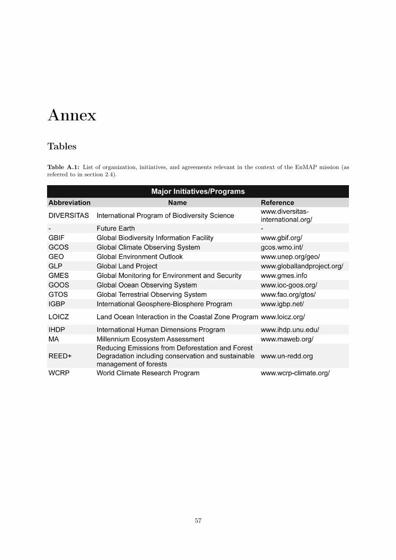
Annex
Tables
Table A.1: List of organization, initiatives, and agreements relevant in the context of the EnMAP mission (asreferred to in section 2.4).
57

Annex
58

List of Figures
1 The EnMAP data processing chain . . . . . . . . . . . . . . . . . . . . . . . . . . . . . . . 11
2 Solar radiation spectrum . . . . . . . . . . . . . . . . . . . . . . . . . . . . . . . . . . . . . 14
3 Reflectance spectra of selected Earth’s surface components . . . . . . . . . . . . . . . . . . 15
4 Spectral and spatial resolution of selected multi- and hyperspectral satellites . . . . . . . . 17
5 Research fields and application areas for imaging spectroscopy . . . . . . . . . . . . . . . . 19
6 Location of study sites investigated with flight campaigns . . . . . . . . . . . . . . . . . . 43
59

List of Tables
1 EnMAP satellite parameters . . . . . . . . . . . . . . . . . . . . . . . . . . . . . . . . . . . 9
2 Key documents of the EnMAP mission . . . . . . . . . . . . . . . . . . . . . . . . . . . . . 41
A.1 List of organization, initiatives, and agreements . . . . . . . . . . . . . . . . . . . . . . . . 57
60