Satellite Networking Introductory Lecture
53
Satellite Networking Introductory Lecture http://web.uettaxila.edu.pk/CMS/SP2015/ http://web.uettaxila.edu.pk/CMS/SP2015/ teSNms/ teSNms/
-
Upload
rodney-gallagher -
Category
Documents
-
view
223 -
download
3
Transcript of Satellite Networking Introductory Lecture

Satellite Networking
Introductory Lecture
http://web.uettaxila.edu.pk/CMS/SP2015/teSNms/http://web.uettaxila.edu.pk/CMS/SP2015/teSNms/

Overview
Satellite technology has progressed tremendously over the last 50 years since Arthur C. Clarke first proposed its idea in 1945 in his article in Wireless World.
Today, satellite systems can provide a variety of services including broadband communications, audio/video distribution networks, maritime navigation, worldwide customer service and support as well as military command and control.
Satellite systems are also expected to play an important role in the emerging 4G global infrastructure providing the wide area coverage necessary for the realization of the “Optimally Connected Anywhere, Anytime” vision that drives the growth of modern telecom industry.

Course Objectives
This course aims to: Provide a broad overview of the status of digital
satellite communications. Discuss main physical, architectural and
networking issues of satellite systems. Provide in-depth understanding of modern
modulation, coding and multiple access schemes. Review the state of the art in open research areas
such as satellite networking, internet over satellite and satellite personal communications.
Highlight trends and future directions of satellite communication.

Section 1: The SATCOM Industry – System Design Issues /Basics of Satellite Communication
An Overview of Satellite Communications Examples of current military and commercial systems. Satellite orbits and transponder characteristics (LEO, MEO,
GEO) Traffic Connectivity: Mesh, Hub-Spoke, Point-to-Point, Broadcast
Basic satellite transmission theory Impairments of the Satellite Channel: Weather and Doppler
effects, Channel models. Communications Link Calculations: Definition of EIRP, Noise
temperature etc. Transponder gain and SFD. Link Budget Calculations. Down-link requirements. Design of satellite links to achieve a specified performance.
Earth Station Antenna types: Pointing/Tracking. Small antennas at Ku band. FCC-Intelsat-ITU antenna requirements and EIRP density limitations.
Brief introduction to implementation issues: LNA, Up/down converters etc.

Section 2: Elements of Transponder Design – The Baseband / Fixed Satellite System
Physical Layer of the Transponder – The Baseband System
Introduction to the theory of Digital Communications: Modulation, Equalization and FEC
Digital Modulation Techniques: BPSK, QPSK, Nyquist signal shaping.
Overview of Bandwidth Efficient Modulation (BEM) Techniques: M-ary PSK, Trellis Coded 8PSK, QAM.
PSK Receiver Implementation issues: Carrier recovery, phase slips, differential coding.
Overview of Forward Error Correction (FEC): Standard FEC types (Block and Convolution Coding schemes, Viterbi Decoding), Coding Gain, Concatenated coding, Turbo coding.

Section 3: Multiple Access Issues / Satellite Communication Services
Spread Spectrum Techniques: Military and commercial use of spread-spectrum. Direct-Sequence, Frequency-Hop and CDMA systems.
Principles of Multiple Access Communications Multiplexing & Multiple Access FDD/TDD, FDMA, TDMA
Concepts of Random Access: ALOHA, CSMA
Multiple Access Techniques: FDMA, TDMA, CDMA. Demand Assigned Multiple Access (DAMA) and Bandwidth-on-Demand (BoD).
TDMA Networks: Time Slots, Preambles, Suitability for DAMA and BoD.

Section 4: SATCOM Networks and Services / Foundation in Space Marketing Satellite Communication Systems
& Networks Characteristics of IP and TCP/UDP over
satellite: Unicast and Multicast. Need for Performance
Performance Enhancing Proxy (PEP) techniques. VSAT Networks and their system
characteristics. DVB standards and MultiFreq-TDMA
The Future of SATCOM SATCOM’s role in the emerging 4G
Information and Communications (ICT) infrastructure.

Section 5: Space Remote Sensing / Space Remote Sensing Systems
A survey of historical and current remote sensing systems will be presented, covering all major governmental and private systems.
The business of remote sensing, including system development, launch, and operational costs will be presented, along with remote sensing market trends and user communities.

Text Book
Title: The Satellite Communication Applications Handbook
Author: Bruce R. Elbert ISBN: 1580534902 EAN: 9781580534901 Publisher:
Artech House Publishers

Reference Books
Title: Satellite Communications Author: Dennis Roddy ISBN: 0071371761 EAN: 9780071371766 Publisher:
McGraw-Hill Professional

Reference Books
Title: Satellite Communication Engineering Author: Michael O. Kolawole ISBN: 082470777X EAN: 9780071371766 Publisher:
Marcel Dekker, Inc.

Pioneers in Satellite Communication Konstantin Tsiolkovsky (1857 - 1935)
Russian visionary of space flight First described the multi-stage rocket as means of achieving orbit. Link:
The life of Konstantin Eduardovitch Tsiolkovsky Hermann Noordung (1892 - 1929)
Postulated the geostationary orbit. Link:
The Problem of Space Travel: The Rocket Motor
Arthur C. Clarke (1917 – 19 March 2008)Postulated the entire concept of international satellite telecommunications from geostationary satellite orbit including coverage, power, services, solar eclipse. Link: "Wireless World" (1945)

Satellite History Calendar 1957
October 4, 1957: - First satellite - the Russian Sputnik 01
First living creature in space: Sputnik 02
1958
First American satellite: Explorer 01
First telecommunication satellite: This satellite broadcast a taped message: Score
1959
First meteorology satellite: Explorer 07
1960
First successful passive satellite: Echo 1
First successful active satellite: Courier 1B
First NASA satellite: Explorer 08
April 12, 1961: - First man in space
1962
First telephone communication & TV broadcast via satellite: Echo 1
First telecommunication satellite, first real-time active, AT&T: Telstar 1
First Canadian satellite: Alouette 1
On 7th June 1962 at 7:53p the two-stage rocket; Rehbar-I was successfully launched from Sonmiani Rocket Range. It carried a payload of 80 pounds of sodium and soared to about 130 km into the atmosphere. With the launching of Rehbar-I, Pakistan had the honour of becoming the third country in Asia and the tenth in the world to conduct such a launching after USA, USSR, UK, France, Sweden, Italy, Canada, Japan and Israel.
Rehbar-II followed a successful launch on 9th June 1962

Satellite History Calendar 1963
Real-time active: Telstar 2 1964
Creation of Intelsat First geostationary satellite, second satellite in stationary orbit: Syncom 3 First Italian satellite: San Marco 1
1965 Intelsat 1 becomes first commercial comsat: Early Bird First real-time active for USSR: Molniya 1A
1967 First geostationary meteorology payload: ATS 3
1968 First European satellite: ESRO 2B
July 21, 1969: - First man on the moon

Satellite History Calendar 1970
First Japanese satellite: Ohsumi First Chinese satellite: Dong Fang Hong 01
1971 First UK launched satellite: Prospero ITU-WARC for Space Telecommunications INTELSAT IV Launched INTERSPUTNIK - Soviet Union equivalent of INTELSAT formed
1974 First direct broadcasting satellite: ATS 6
1976 MARISAT - First civil maritime communications satellite service
started 1977
EUTELSAT - European regional satellite ITU-WARC for Space Telecommunications in the Satellite Service
1979 Creation of Inmarsat (International Marine Satellite)

Satellite History Calendar 1980
INTELSAT V launched - 3 axis stabilized satellite built by Ford Aerospace
1983
ECS (EUTELSAT 1) launched - built by European consortium supervised by ESA
1984
UK's UNISAT TV DBS satellite project abandoned
First satellite repaired in orbit by the shuttle: SMM
1985
First Brazilian satellite: Brazilsat A1
First Mexican satellite: Morelos 1
1988
First Luxemburg satellite: Astra 1A
1989
INTELSAT VI - one of the last big "spinners" built by Hughes
Creation of Panamsat - Begins Service
1990
IRIDIUM, TRITIUM, ODYSSEY and GLOBALSTAR S-PCN projects proposed - CDMA designs more popular
EUTELSAT II
On 16 July 1990, Pakistan launched its first experimental satellite, BADR-I from China

Satellite History Calendar 1992
OLYMPUS finally launched - large European development satellite with Ka-band, DBTV and Ku-band SS/TDMA payloads - fails within 3 years
1993
INMARSAT II - 39 dBW EIRP global beam mobile satellite - built by Hughes/British Aerospace
1994
INTELSAT VIII launched - first INTELSAT satellite built to a contractor's design
Hughes describe SPACEWAY design
DirecTV begins Direct Broadcast to Home
1995
Panamsat - First private company to provide global satellite services.
1996
INMARSAT III launched - first of the multibeam mobile satellites (built by GE/Marconi)
Echostar begins Diresct Broadcast Service
1997
IRIDIUM launches first test satellites
ITU-WRC'97
1999
AceS launch first of the L-band MSS Super-GSOs - built by Lockheed Martin
Iridium Bankruptcy - the first major failure?

Satellite History Calendar 2000
Globalstar begins service Thuraya launch L-band MSS Super-GSO
2001 XM Satellite Radio begins service Pakistan’s 2nd Satellite, BADR-B was launched on 10 Dec 2001 at 9:15a from Baikonour
Cosmodrome, Kazakistan 2002
Sirius Satellite Radio begins service Paksat-1, was deployed at 38 degrees E orbital slot in December 2002
2004 Teledesic network planned to start operation
2005 Intelsat and Panamsat Merge VUSat OSCAR-52 (HAMSAT) Launched
2006 CubeSat-OSCAR 56 (Cute-1.7) Launched
K7RR-Sat launched by California Politechnic University
2007 Prism was launched by University of Tokyo
2008 COMPASS-1; a project of Aachen University was launched from Satish Dawan Space Center,
India. It failed to achieve orbit.

Intelsat INTELSAT is the original "International
Telecommunications Satellite Organization". It once owned and operated most of the World's satellites used for international communications, and still maintains a substantial fleet of satellites.
INTELSAT is moving towards "privatization", with increasing competition from commercial operators
(e.g. Panamsat, Loral Skynet, etc.).
INTELSAT Timeline: Interim organization formed in 1964 by 11
countries
Permanent structure formed in 1973
Commercial "spin-off", New Skies Satellites in 1998
Full "privatization" by April 2001 INTELSAT has 143 members and signatories listed
here.

Intelsat Structure

Eutelsat
Permanent General Secretariat opened September 1978
Intergovernmental Conference adopted definitive statutes with 26 members on 14 May 1982
Definitive organization entered into force on 1 September 1985
General Secretariat -> Executive Organ
Executive Council -> EUTELSAT Board of Signatories
Secretary General -> Director General
Current DG is Michel de Rosen
Currently almost 50 members
Moving towards "privatization"
Limited company owning and controlling of all assets and activities
Also a "residual" intergovernmental organization which will ensure that basic principles of pan-European coverage, universal service, non-discrimination and fair competition are observed by the company

Eutelsat Structure

Communication Satellites
A Communication Satellite can be looked upon as a large microwave repeater
It contains several transponders which listens to some portion of spectrum, amplifies the incoming signal and broadcasts it in another frequency to avoid interference with incoming signals.

Motivation to use Satellites
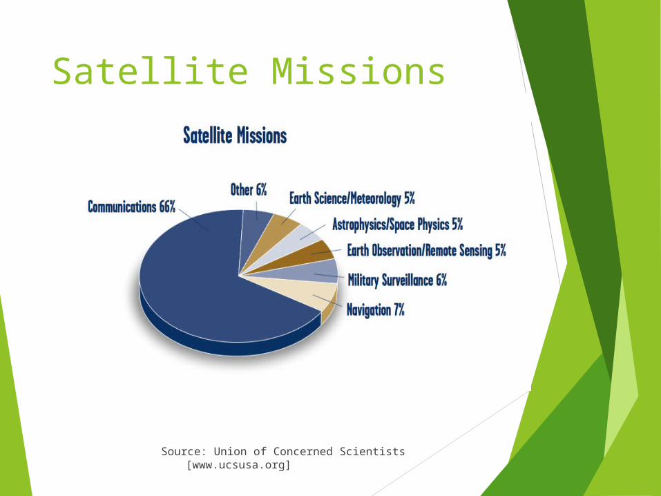
Satellite Missions
Source: Union of Concerned Scientists [www.ucsusa.org]

Satellite Microwave Transmission Satellites can relay signals over a long distance
Geostationary Satellites
Remain above the equator at a height of about 22300 miles (geosynchronous orbits)
Travel around the earth in exactly the same time, the earth takes to rotate

Satellite System Elements

Space Segment
Satellite Launching Phase Transfer Orbit Phase Deployment Operation
TT&C - Tracking Telemetry and Command Station
SSC - Satellite Control Center, a.k.a.: OCC - Operations Control Center
SCF - Satellite Control Facility
Retirement Phase

Ground Segment Collection of facilities, Users and Applications
Earth Station = Satellite Communication Station (Fixed or Mobile)

Satellite Uplink and Downlink
Downlink The link from a satellite down to one or
more ground stations or receivers Uplink
The link from a ground station up to a satellite.
Some companies sell uplink and downlink services to television stations, corporations, and to
other telecommunication carriers. A company can specialize in providing
uplinks, downlinks, or both.

Satellite Uplink and Downlink

Satellite Communication
Source: Cryptome [Cryptome.org]
When using a satellite for long When using a satellite for long distance communications, the distance communications, the satellite acts as a repeater.satellite acts as a repeater.
An earth station transmits the An earth station transmits the signal up to the satellite signal up to the satellite (uplink), which in turn (uplink), which in turn retransmits it to the receiving retransmits it to the receiving earth station (downlink).earth station (downlink).
Different frequencies are used Different frequencies are used for uplink/downlink.for uplink/downlink.

Satellite Transmission Links
Earth stations Communicate by sending signals to the satellite on an uplink
The satellite then repeats those signals on a downlink
The broadcast nature of downlink makes it attractive for services such as the distribution of TV programs

Direct to User Services
One way Service (Broadcasting)One way Service (Broadcasting) Two way Service (Communication)Two way Service (Communication)

Satellite Signals
Used to transmit signals and data over long distances
Weather forecasting
Television broadcasting
Internet communication
Global Positioning Systems

Satellite Transmission Bands
Frequency Band Downlink Uplink
C 3,700-4,200 MHz 5,925-6,425 MHz
Ku 11.7-12.2 GHz 14.0-14.5 GHz
Ka 17.7-21.2 GHz 27.5-31.0 GHz
The C band is the most frequently used. The Ka and Ku bands are reserved exclusively for satellite communication but are subject to rain attenuation

Types of Satellite Orbits
Based on the inclination, i, over the equatorial plane: Equatorial Orbits above Earth’s equator (i=0°) Polar Orbits pass over both poles (i=90°) Other orbits called inclined orbits (0°<i<90°)
Based on Eccentricity Circular with centre at the earth’s centre Elliptical with one foci at earth’s centre

Types of Satellite based Networks
Based on the Satellite Altitude GEO – Geostationary Orbits
36000 Km = 22300 Miles, equatorial, High latency
MEO – Medium Earth Orbits High bandwidth, High power, High latency
LEO – Low Earth Orbits Low power, Low latency, More Satellites, Small
Footprint
VSAT Very Small Aperture Satellites
Private WANs

Satellite Orbits
Source: Federation of American Scientists [www.fas.org]
Geosynchronous Orbit (GEO): Geosynchronous Orbit (GEO): 36,000 km above Earth, 36,000 km above Earth, includes commercial and includes commercial and military communications military communications satellites, satellites providing satellites, satellites providing early warning of ballistic early warning of ballistic missile launch.missile launch.
Medium Earth Orbit (MEO): Medium Earth Orbit (MEO): from 5000 to 15000 km, they from 5000 to 15000 km, they include navigation satellites include navigation satellites (GPS, Galileo, Glonass).(GPS, Galileo, Glonass).
Low Earth Orbit (LEO): from Low Earth Orbit (LEO): from 500 to 1000 km above Earth, 500 to 1000 km above Earth, includes military intelligence includes military intelligence satellites, weather satellites.satellites, weather satellites.

Satellite Orbits

GEO - Geostationary Orbit
In the equatorial plane
Orbital Period = 23 h 56 m 4.091 s = 1 sidereal day*
Satellite appears to be stationary over any point on equator: Earth Rotates at same speed as Satellite Radius of Orbit r = Orbital Height + Radius of
Earth Avg. Radius of Earth = 6378.14 Km
3 Satellites can cover the earth (120° apart)

NGSO - Non Geostationary Orbits
Orbit should avoid Van Allen radiation belts: Region of charged
particles that can cause damage to satellite
Occur at ~2000-4000 km and ~13000-25000 km

LEO - Low Earth Orbits
Circular or inclined orbit with < 1400 km altitude Satellite travels across sky from horizon to
horizon in 5 - 15 minutes => needs handoff Earth stations must track satellite or have
Omni directional antennas Large constellation of satellites is needed for
continuous communication (66 satellites needed to cover earth)
Requires complex architecture Requires tracking at ground

HEO - Highly Elliptical Orbits
HEOs (i = 63.4°) are suitable to provide coverage at high latitudes (including North Pole in the northern hemisphere)
Depending on selected orbit (e.g. Molniya, Tundra, etc.) two or three satellites are sufficient for continuous time coverage of the service area.
All traffic must be periodically transferred from the “setting” satellite to the “rising” satellite (Satellite Handover)

Satellite Orbits
Source: Union of Concerned Scientists [www.ucsusa.org]
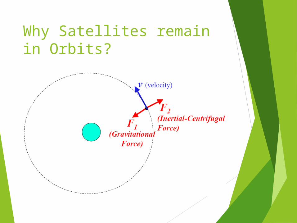
Why Satellites remain in Orbits?

Advantages of Satellite Communication Can reach over large geographical area Flexible (if transparent transponders) Easy to install new circuits Circuit costs independent of distance Broadcast possibilities Temporary applications (restoration) Niche applications Mobile applications (especially "fill-in") Terrestrial network "by-pass" Provision of service to remote or
underdeveloped areas User has control over own network 1-for-N multipoint standby possibilities

Disadvantages of Satellite Communication Large up front capital costs (space segment and
launch)
Terrestrial break even distance expanding (now approx. size of Europe)
Interference and propagation delay
Congestion of frequencies and orbits

When to use Satellites
When the unique features of satellite communications make it attractive
When the costs are lower than terrestrial routing
When it is the only solution Examples:
Communications to ships and aircraft (especially safety communications)
TV services - contribution links, direct to cable head, direct to home
Data services - private networks Overload traffic Delaying terrestrial investments 1 for N diversity Special events

When to use Terrestrial
PSTN - satellite is becoming increasingly uneconomic for most trunk telephony routes
but, there are still good reasons to use satellites for telephony such as: thin routes, diversity, very long distance traffic and remote locations.
Land mobile/personal communications - in urban areas of developed countries new terrestrial infrastructure is likely to dominate (e.g. GSM, etc.)
but, satellite can provide fill-in as terrestrial networks are implemented, also provide similar services in rural areas and underdeveloped countries

Frequency Bands Allocated to the FSS Frequency bands are allocated to different
services at World Radio-communication Conferences (WRCs).
Allocations are set out in Article S5 of the ITU Radio Regulations.
It is important to note that (with a few exceptions) bands are generally allocated to more than one radio services.
CONSTRAINTS Bands have traditionally been divided into
“commercial" and "government/military" bands, although this is not reflected in the Radio Regulations and is becoming less clear-cut as "commercial" operators move to utilize "government" bands.

Earth’s atmosphere
Source: All about GPS [www.kowoma.de]

Q&A
????