SASEG Swiss Association of Energy Geoscientists Annual ... · SASEG Swiss Association of Energy...
26
SASEG Swiss Association of Energy Geoscientists Annual Convention 2015 Baden Excursion field guide: Stratigraphy and tectonics of Jurassic Formations of the Eastern Jura Mountains Sunday 21 st June 2015 Guidance: Dr. W. Heckendorn, Dr. H. Madritsch, Dr. B. Meier & Dr. M.Schnellmann
Transcript of SASEG Swiss Association of Energy Geoscientists Annual ... · SASEG Swiss Association of Energy...

SASEG Swiss Association of Energy Geoscientists
Annual Convention 2015 Baden
Excursion field guide:
Stratigraphy and tectonics of Jurassic Formations of the Eastern Jura Mountains
Sunday 21st June 2015
Guidance: Dr. W. Heckendorn, Dr. H. Madritsch, Dr. B. Meier & Dr. M.Schnellmann

STOP 1: Habsburg: Geological Introduction (ca. Coo.: 656’100/257’200)
Fig. 1.1: Large scale geological frame (Nagra 2014)

Fig. 1.2: Regional geological setting: Tectonic map of central northern Switzerland and cross section across the eastern Jura Mountains (modified from Madritsch, 2015 submitted, see also Nagra 2014)

Fig. 1.3: Geological Map with location of excursion stops (modified from Nagra 2014)
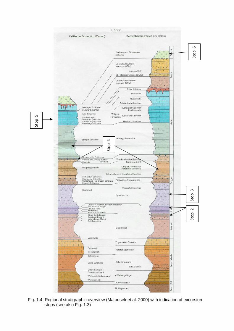
Fig. 1.4: Regional stratigraphic overview (Matousek et al. 2000) with indication of excursion stops (see also Fig. 1.3)
Stop
5
Stop
4
Stop
2
Stop
3
Stop
6

Fig. 1.5: Seismic section across the thrust fault underneath the Habsburg (Profile 11-NS-06 in Fig. 1-3; Madritsch et al. 2013).

STOP 2: Clay quarry Frick (ca. Coo.: 643’000/261’900)
Fig. 2.1: Triassic section outcrop in the clay quarry Frick
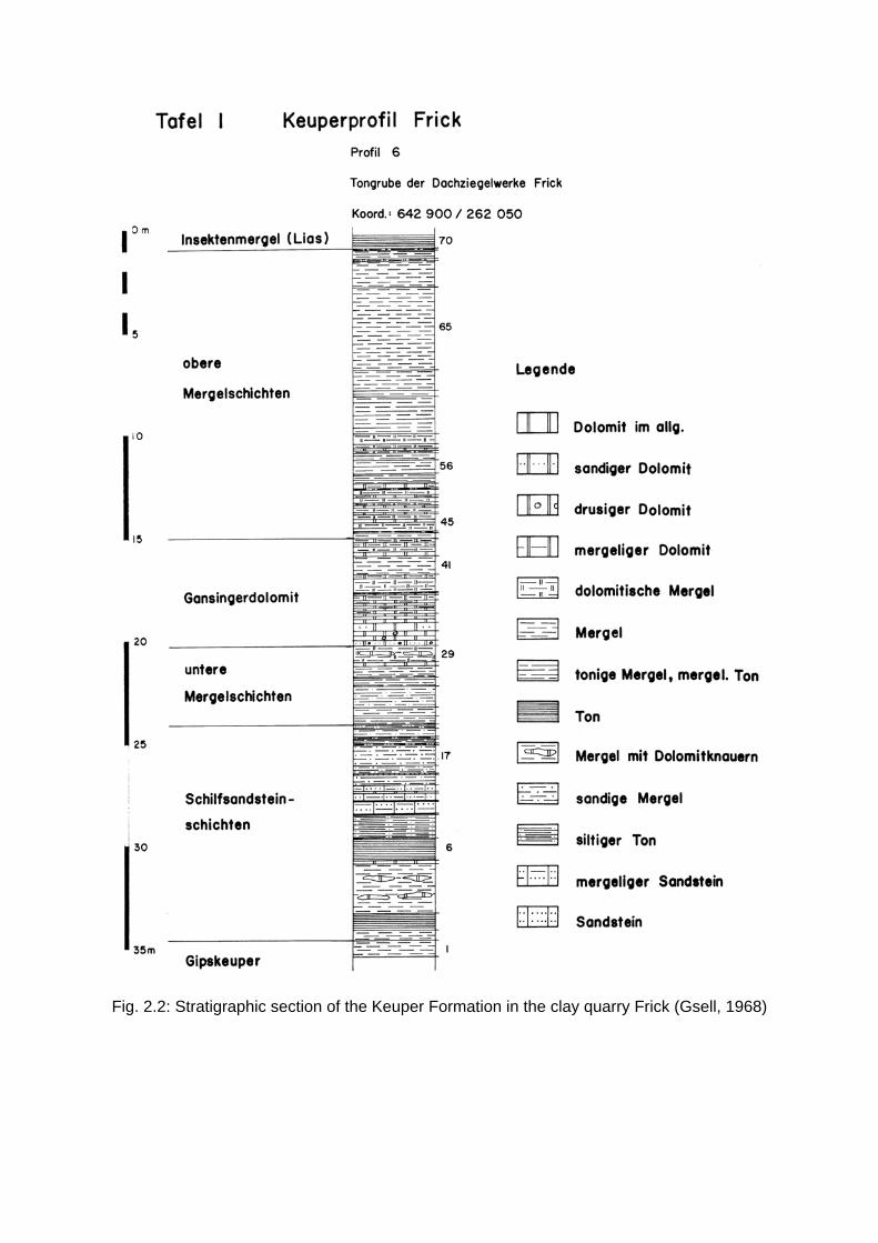
Fig. 2.2: Stratigraphic section of the Keuper Formation in the clay quarry Frick (Gsell, 1968)

Fig. 2.3: The Staffelegg Formation as exposed in the clay quarry Frick.

Fig. 2.4: Stratigraphic section of the Staffelegg Formation as exposed in the clay quarry Frick (from Reisdorf et al. 2011)

Fig. 2.4: Schematic illustration of potentially water conducting features within a clay rich succession intercalated by “hard beds” (lime- and sandstones) characterized by a significantly lower clay content and hence comparable poor self sealing properties. Within such hard beds small scale faults can potentially favor lateral fluid transport (Nagra 2014).

Fig. 2.5: Regional facies map of the Staffelegg Formation showing more systematically more calcareous and sandy facies variation to the south of the Folded Jura (Kiefer et al. 2015).

STOP 3: Opalinus Clay quarry Holderbank (ca. Coo.: 654’900/254’000)
Fig. 3.1: Opalinus Clay thrusted unto overturned younger Jurassic rocks within the Chestenberg thrust zone (compare Fig. 1.3 and 1.5). Close up image of a fault zone in Opalinus Clay as previously exposed in this quarry (Nagra 2014).

STOP 4: Marl quarry Holderbank (Schümmel; ca. Coo.: 655’200/253’200)
Fig. 4.1: Outcrop situation in the Schümmel outrcrop (note the white info board for reference and scale). View to the East, Klingnau-Formation and Spatkalk dipping to the South, horizontal bedding on topmost bench marks roof of the Chestenberg-Anticline (see also Fig. 1.4).

Fig. 4.2: Stratigraphic units of the Dogger units above the Opalinus Clay (Nagra 2014).

Fig. 4.3: Litho-stratigraphic & facies correlation of the “Brauner Dogger” succession across key outcrops and deep well in central northern Switzerland (from Bläsi et al. 2013).

Fig. 4.4: Overview of Oxfordian Formation in Switzerland including the Wildegg Formation: W-E section through the formaions of the Oxfordian following Gygi (2000) and paleogeographic situation at the deposition time of the Effingen Beds following Gygi 1990 (compiled and redrawn Figure from Deplazes et al. 2013).

Fig. 4.5: Overview of the nearby quarry Jakobsberg showing the Upper Effingen Beds with characteristic succession of limestone beds and the underlying limestone rich Gerstenhübel Schichten (from Deplazes et al. 2013).

Fig. 4.6: Geological and geophysical logs of the Wildegg Formation south of the Folded Jura indicating a good regional correlation of limestone rich hard beds expressed by a lower clay content in the geophysical logs (Nagra 2014).

Fig. 4.7: Outcrop-scale fracture systems in the Effingen beds with kinematic slip indicator.
Fig. 4.8: Kinematic analysis and tectonic implications of similar observations from within the eastern Jura Mountains (from Madritsch 2015).

STOP 5: Upper Malm section close by Villigen (ca. Coo: 658’000/264’000)
For stratigraphic overview refer to Fig. 1.4
Fig. 5.2: 2D-seismic sections along the lower Aare Valley (11-NS-10 in Fig. 1.3) showing the eastern continuation of the Lägern Anticline in the south, Siggenthal Anticline in the center and the Mandach Thrust in the north (Madritsch et al. 2013).

Fig. 5.3: 2D-seismic sections along the lower Aare Valley (11-NS-12 in Fig. 1.3) showing the eastern continuation of the Lägern Anticline in the south, Siggenthal Anticline in the center and the Mandach Thrust in the north (Madritsch et al. 2013).

STOP 6: Mandach Thrust near the Beznau Isle (ca. Coo. 659’400/266’700)
Fig. 6.1: Geological situation around the Beznau Isle (taken from Nagra 2014)

Fig. 6.2: High resolution digital terrain model of the Beznau based on airborne LiDAR data with topographic profiles across the projected trace of the Mandach Thrust fault trace (taken from Nagra 2014).

Fig. 6.3: Digital Terrain Model of the Lower Aare Valley with simplified traces of major regional fault traces and key Quaternary terrace deposits (see inset). The latter allow reconstructing the Quaternary landscape evolution and can potentially be used as geomorphic markers for neotectonic investigations.

References:
Bläsi, H.R., Deplazes, G., Schnellmann, M. & Traber, D. (2013): Sedimentologie und Strati-graphie des 'Braunen Doggers' und seiner westlichen Äquivalente. Nagra Arbeitsber. NAB 12-51.
Deplazes, G., Bläsi, H.R., Schnellmann, M. & Traber, D. (2013): Sedimentologie und Strati-graphie der Effinger Schichten. Nagra Arbeitsber. NAB 13-16.
Gsell, F. (1968): Geologie des Falten- und Tafeljura zwischen Aare und Wittnau und Betrachtungen zur Tektonik des Ostjura zwischen dem Unteren Hauenstein im W und der Aare im E. Universität Zürich.
Gygi, R.A. (1990): Die Paläogeographie im Oxfordium und frühesten Kimmeridgium in der Nordschweiz. Jahreshefte des Geologischen Landesamtes Baden-Württemberg 32, 207-222.
Gygi, R.A. (2000b): Integrated stratigraphy of the Oxfordian and Kimmeridgian (Late Jurassic) in northern Switzerland and adjacent southern Germany. Denkschriften der Schweizerischen Akademie der Naturwissenschaften 104. Birkhäuser, Basel.
Kiefer, L., Deplazes, G., Bläsi, H.R. (2015): Sedimentologie und Stratigraphie des frühen Juras in der Nordschweiz: Staffelegg-Formation und sich nach Osten anschliessende Vorkommen. Nagra Arbeitsber. NAB 14-95.
Madritsch, H. (2015): Outcrop-scale fracture systems in northern central Switzerland: Kinematics and tectonic context. Swiss Journal of Geosciences Submitted.
Madritsch, H., Meier, B., Kuhn, P., Roth, P., Zingg, O., Heuberger, S., Naef, H. & Birkhäuser, P. (2013): Regionale strukturgeologische Zeitinterpretation der Nagra 2D-Seismik 2011/12. Nagra Arbeitsber. NAB 13-10.
Matousek, F., Wanner, M., Baumann, A., Graf, H.R., Nüesch, R. & Bitterli, T. (2000). Geo-logischer Atlas der Schweiz 1:25'000, Blatt 1050 Zurzach mit Erläuterungen. Bundesamt für Landestopografie swisstopo, Wabern (Bern).
Nagra (2014): SGT Etappe 2: Vorschlag weiter zu untersuchender geologischer Standort-gebiete mit zugehörigen Standortarealen für die Oberflächenanlage: Geologische Grundlagen Dossier II Sedimentologische und tektonische Verhältnisse: Nagra Tech. Ber. NTB 14-02
Reisdorf, A.G., Wetzel, A., Schlatter, R., Jordan, P. (2011): The Staffelegg Formation: a new stratigraphic scheme for the Early Jurassic of northern Switzerland. Swiss Journal of Geosciences 104/1, 97-146.