
Saracen Mineral Holdings Limited Strong start to FY20 ... · results include 21.9m @ 5.6g/t, 16.5m...
53
Saracen Mineral Holdings Limited Strong start to FY20 exploration campaign paves way for further inventory growth Latest drilling results highlight the potential to continue increasing production and mine life at Carosue Dam and Thunderbox Registered Office: Level 11/40 The Esplanade Perth WA 6000 ASX:SAR 18 th February 2020 HIGHLIGHTS Carosue Dam At Karari - Dervish, thick high-grade drill results included 22m @ 5.6g/t, 17m @ 6.9g/t, 14m @ 8.0g/t, 10m @ 10.7g/t, 14m @ 5.1g/t and 16m @ 4.5g/t At the Carosue Dam Seismic Project, data has been received and interpretation has commenced At the Atbara discovery (just 4km from the Carosue Dam mill), infill drill results included (aggregated): 86m @ 1.8g/t (including 45m @ 1.8g/t, 9m @ 5.7g/t and 32m @ 0.8g/t) 51m @ 1.5g/t (including 37m @ 1.4g/t and 14m @ 1.7g/t) 359m @ 0.5g/t At Safari Bore, open pit-able drill results included 4m @ 19.3g/t, 26m @ 2.4g/t, 45m @ 1.5g/t and 36m @ 2.1g/t At Mt Celia regional, air core drilling has defined the Okavango prospect, with results up to 1050ppb, RC drilling has commenced Thunderbox At Otto Bore, open pit-able drill results included 15m @ 11.2g/t, 16m @ 5.7g/t and 7m @ 5.3g/t At Wonder North, Resource definition drilling has commenced (focused on the high grade shoot) Super Pit acquisition Saracen and its equal KCGM JV partner Northern Star Resources (ASX: NST) have established an “exploration and growth” sub-committee and initiated a strategic review / optimisation that includes exploration and growth Pending the outcome of the review, 5 surface and 2 underground rigs continue to drill under the plan approved by former owners Saracen Managing Director Raleigh Finlayson said: “These results show that Saracen continues to enjoy a strong growth outlook driven by both organic sources and prudent acquisitions. They are consistent with our goal to keep expanding our production and mine life for what are low discovery costs. At the same time, our Carosue Dam mill expansion is on track for commissioning in the December quarter, further underpinning our growth profile.” For personal use only
Transcript of Saracen Mineral Holdings Limited Strong start to FY20 ... · results include 21.9m @ 5.6g/t, 16.5m...

Saracen Mineral Holdings Limited
Strong start to FY20 exploration campaign
paves way for further inventory growth
Latest drilling results highlight the potential to continue increasing
production and mine life at Carosue Dam and Thunderbox
Registered Office:
Level 11/40 The Esplanade
Perth WA 6000 ASX:SAR
18th February 2020
HIGHLIGHTS
Carosue Dam
At Karari - Dervish, thick high-grade drill results included 22m @ 5.6g/t, 17m @ 6.9g/t, 14m @ 8.0g/t, 10m @ 10.7g/t, 14m
@ 5.1g/t and 16m @ 4.5g/t
At the Carosue Dam Seismic Project, data has been received and interpretation has commenced
At the Atbara discovery (just 4km from the Carosue Dam mill), infill drill results included (aggregated):
86m @ 1.8g/t (including 45m @ 1.8g/t, 9m @ 5.7g/t and 32m @ 0.8g/t)
51m @ 1.5g/t (including 37m @ 1.4g/t and 14m @ 1.7g/t)
359m @ 0.5g/t
At Safari Bore, open pit-able drill results included 4m @ 19.3g/t, 26m @ 2.4g/t, 45m @ 1.5g/t and 36m @ 2.1g/t
At Mt Celia regional, air core drilling has defined the Okavango prospect, with results up to 1050ppb, RC drilling has
commenced
Thunderbox
At Otto Bore, open pit-able drill results included 15m @ 11.2g/t, 16m @ 5.7g/t and 7m @ 5.3g/t
At Wonder North, Resource definition drilling has commenced (focused on the high grade shoot)
Super Pit acquisition
Saracen and its equal KCGM JV partner Northern Star Resources (ASX: NST) have established an “exploration and
growth” sub-committee and initiated a strategic review / optimisation that includes exploration and growth
Pending the outcome of the review, 5 surface and 2 underground rigs continue to drill under the plan approved by former
owners
Saracen Managing Director Raleigh Finlayson said: “These results show that Saracen continues to enjoy a strong growth outlook
driven by both organic sources and prudent acquisitions. They are consistent with our goal to keep expanding our production and
mine life for what are low discovery costs. At the same time, our Carosue Dam mill expansion is on track for commissioning in the
December quarter, further underpinning our growth profile.”
For
per
sona
l use
onl
y

Page 2 of 53
Carosue Dam update
Karari - Dervish underground
Karari drilling has continued to focus on infill grade control following a solid increase in Ore Reserves to 1.2Moz at 30 June 2019.
This drilling was the final program from the 1940 drill drive, with the new drill drive on the 1805 level now established.
Recent drilling has returned thick high grade results further demonstrating the increasing grade profile with depth. Significant
results include 21.9m @ 5.6g/t, 16.5m @ 6.9g/t and 14.0m @ 8.0g/t. The high grade shoots remain open at depth and will be tested
further during FY20.
Figure 1 - Karari Long Section, New Drill Results (Karari-Dervish mine)
The new 1805 drill platform is located 135m below the existing drill platform and will facilitate the next phase of Reserve growth,
weighted to FY21. This will be counterbalanced by enhanced contributions in FY20 from other areas within the portfolio. Resource
extension drilling has commenced and will continue to test the strong high grade mineralisation down plunge.
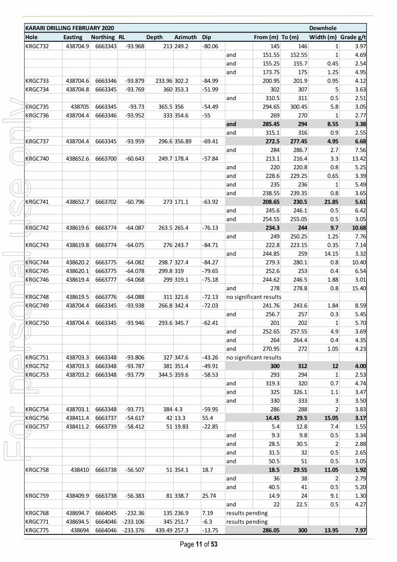
Below is a table of significant Karari infill intercepts:
Significant drill results include:
KRGC741 21.9m @ 5.6g/t
KRGC712 16.5m @ 6.9g/t
KRGC775 14.0m @ 8.0g/t
KRGC742 9.7m @ 10.7g/t
KRGC715 14.4m @ 5.1g/t
KRGC723 15.7m @ 4.5g/t
For
per
sona
l use
onl
y

Page 3 of 53
Carosue Dam Seismic Project
Data processing of the 3D seismic survey is now complete, with interpretation underway.
The high-resolution fully nodal acquisition recorded 263 million traces of seismic data over 50km2 including Karari, Dervish and
Atbara. This is the highest resolution hard rock survey in Australia and the second largest by area to date. The significant size
of the dataset slowed progress, but was overcome by increased processing capacity.
Interpretation of the high resolution survey has commenced with a significant number of previously unknown structural and
geological features beginning to be resolved.
The interpretation phase is an iterative process as new mapping and drilling information is integrated into the cube.
Figure 2 - Carosue Dam, 3D Seismic data
Once the detailed geological framework is established, drill targets can be determined.
Atbara (Carosue Dam Corridor)
The Atbara discovery, 4km north of the Carosue Dam mill, continues to evolve with further drilling.
The initial broad 160m x 160m framework drilling identified a large system with a strike length of 860m between two major post
mineralisation Proterozoic Dykes. Initial follow up drilling to the discovery hole (40m @ 3.8g/t) suggested that the mineralisation
is highly variable.
Recently a close spaced 20m x 20m program was completed to assist in understanding the short range variability.
Significant new Atbara results include 45m @ 1.8g/t, 54m @ 1.4g/t and 359m @ 0.5g/t.
For
per
sona
l use
onl
y

Page 4 of 53
Figure 3 - Atbara Long Section, New Drill Results, (dotted outline 20m x 20m focus area)
The geological factors that explain the variability are still being determined.
During the December quarter 2019 over 15,000 pulp samples were sent off for Copper and Molybdenum analysis. The results
indicate that while copper and molybdenum are present, the quantities are too low to be considered currently economic.
The variable grade distribution across the project allows for flexibility in any future approach. Current drilling has shown the
presence of large lower grade domains as well as more discrete higher grade zones, both of which will be followed up and
investigated further.
Below is a table of significant Atbara exploration intercepts:
Significant drill results include:
Aggregated Primary (or including)
ATEX108 86.0m @ 1.8g/t 45.0m @ 1.8g/t
9.0m @ 5.7g/t
32.0m @ 0.8g/t
ATEX0110 51.0m @ 1.5g/t 37.0m @ 1.4g/t 14.0m @ 1.7g/t
ATEX114 54.3m @ 1.4g/t 54.3m @ 1.4g/t
ATEX111 56.0m @ 0.9g/t 9.0m @ 2.5g/t 47.0m @ 0.7g/t
ATEX118 13.0m @ 1.8/t 13.0m @ 1.8g/t
For
per
sona
l use
onl
y

Page 5 of 53
Safari Bore
The Safari Bore project is located 70km north-northeast of the Carosue Dam mill, and 5km west of the Deep South underground
mine. Mineral Resources of 2.9Mt at 2.1g/t for 200,000 ounces were reported at 30 June 2019.
The project was previously mined between 2003 and 2005, producing 210,000 ounces at an impressive open pit grade of
2.9g/t. The last drilling at Safari Bore was completed by Saracen in 2010.
Significant open pit-able results from recent Resource definition drilling include 4m @ 19.3g/t, 21m @ 2.5g/t and 26m @ 2.4g/t.
Figure 4 - Safari Bore Long Section, New Drill Results
The high grade shoots remain open down plunge with further drilling to be planned.
Safari Bore sits adjacent to the large regional Pinjin Fault. The steeply west south-westerly dipping stratigraphy is highly deformed
with mylonitic fabrics commonly observed. High grade mineralisation is commonly associated with intense sericite-albite
alteration proximal to quartz-carbonate veining and local brecciation.
Below is a table of significant Safari Bore intercepts:
Significant drill results include:
SBRD007 4.0m @ 19.3g/t
SBRD027 26.0m @ 2.4g/t
SBRD015 45.0m @ 1.5g/t
SBRD005 21.0m @ 2.5g/t
SBRD003 36.0m @ 2.1g/t
For
per
sona
l use
onl
y

Page 6 of 53
Mt Celia regional
Aircore drilling has successfully identified a large gold anomaly (Okavango) to the west of Safari Bore, now defined over a
strike length of 6.0km and up to 1.2km wide. The prospect is a strong basement anomaly that is coincident with albite-sericite
alteration and key pathfinder elements including; As, Bi, Mo, Sb, Te and Ce.
The infill aircore drilling program across the Okavango prospect has now been completed. This program has reduced the drill spacing
down to 200m x 100m. The program has further refined and delineated the core of the anomaly.
Significant new Okavango results include 1050ppb, 964ppb and 879ppb.
Figure 5 - Mt Celia, Aircore drilling results
RC drilling has commenced at Okavango to test the bedrock for primary mineralisation responsible for the large anomalous
footprint defined in the aircore drilling.
No further aircore drilling is planned at the broader Mt Celia area for the remainder of FY20. Additional drilling is planned for FY21 to
follow up on other areas of significant anomalism defined in the broad 900m x 100m programs completed in FY19 and FY20.
For
per
sona
l use
onl
y

Page 7 of 53
Thunderbox update
Otto Bore
Drilling has continued at the Otto Bore project, 8km north of the Thunderbox Plant. A maiden Ore Reserve of 950kt at 2.0g/t for
60,000 ounces was reported at 30 June 2019.
Recent activity has focused on extending the drilling coverage north of the current Ore Reserve. This drilling has further
demonstrated the growth potential of the project with some impressive open pit-able results being returned including 15m @
11.2g/t, 16m @ 5.7g/t and 7m @ 5.3 g/t.
Figure 6 - Otto Bore, New Drill Results
The high grade mineralisation appears confined to shallow south plunging ore shoots.
The strike length of the mineralised structure has now been tested over 1.5km.
Below is a table of significant Otto Bore intercepts:
Significant drill results include:
OBRC0189 15.0m @ 11.2g/t
OBRC0192 16.0m @ 5.7g/t
OBRC0149 7.0m @ 5.3g/t
OBRC0165 6.0m @ 4.8g/t
OBRC0184 11.0m @ 1.9g/t
For
per
sona
l use
onl
y

Page 8 of 53
Wonder North
In the September quarter 2019, Saracen acquired Bligh Resources (ASX: BGH) including the Bundarra Project. The project comprises
5 deposits with a total Mineral Resource of 9.6Mt @ 2.1g/t for 660,000 ounces.
Wonder North is the largest deposit and will be the focus of drilling in the June half 2020. The drilling will be focused on:
Infilling the Resource to improve geological confidence
Confirming previous high grade drilling results
The well-developed high grade shoot which plunges to the south will be the primary focus of the initial program. Step out exploration
programs will be planned for FY21.
Previous drilling results at Wonder North include 22m @ 6.0g/t, 24m @ 5.5g/t and 22m @ 4.3g/t.
Figure 7 - Wonder North, Planned drilling
The Bundurra project is characterised by large volumes of tonalities with assimilated rafts of mafic xenoliths from the greenstone in
which the tonalite has intruded. The tonalities have been later intruded by porphyries, fractionated intrusions and lamprophyres.
Wonder North is hosted within a package of coarse grained tonalite-granodiorite with diorite porphyry, aplite and lamprophyre dykes
and sills. Mineralisation is associated with a west northwest trending Wonder Shear zone with quartz veining containing pyrite.
For
per
sona
l use
onl
y

Page 9 of 53
Corporate structure:
Ordinary shares on issue: 1,102.9m
Unvested employee performance rights: 17.2m
Market Capitalisation: A$4.6b (share price A$4.21)
Cash, bullion and investments (31 December): A$283.8m
Debt (31 December): A$385.0m
Substantial Shareholders: Van Eck Global 12.0%
BlackRock Group 9.8%
For further information please contact:
Investors: Media Enquiries:
Troy Irvin Read Corporate
Corporate Development Officer Paul Armstrong / Nicholas Read
Email: [email protected] Email: [email protected]
Contact (08) 6229 9100 Contact: (08) 9388 1474
Competent Person Statements
The information in the report to which this statement is attached that relates to Exploration Results and Mineral Resources related to Gold is based upon information compiled
by Mr Daniel Howe, a Competent Person who is a member of The Australasian Institute of Mining and Metallurgy and the Australian Institute of Geoscientists. Daniel Howe is a
full-time employee of the company. Daniel Howe has sufficient experience that is relevant to the style of mineralisation and type of deposit under consideration and to the activity
being undertaken to qualify as a Competent Person as defined in the 2012 Edition of the ‘Australasian Code for Reporting of Exploration Results, Mineral Resources and Ore
Reserves’. Daniel Howe consents to the inclusion in the report of matters based on his information in the form and context in which it appears.
For
per
sona
l use
onl
y

Page 10 of 53
Table 1 – Karari Drill Results
KARARI DRILLING FEBRUARY 2020 Downhole
Hole Easting Northing RL Depth Azimuth Dip From (m) To (m) Width (m) Grade g/t
KREX060 438697 6664049 -233.106 640.6 322.5 -57.59 no significant results
KRGC703 438619.7 6663777 -63.586 141 301 -51.76 hole not sampled
KRGC708 438619.6 6663777 -63.771 72 304.7 -45.95 hole not sampled
KRGC708A 438619.5 6663777 -62.584 309.6 308.2 -46.43 285.5 285.9 0.4 3.64
KRGC709 438619.6 6663777 -62.584 330 304.7 -34.56 289 305.2 16.2 2.88
KRGC710 438619.8 6663777 -62.594 342 306.3 -37.46 284.45 296 11.55 2.06
KRGC711 438619.8 6663777 -63.78 153 308.2 -40.34 hole not sampled
KRGC712 438620.4 6663778 -63.785 384 312.4 -39.4 337 353.5 16.5 6.87
and 360.9 361.95 1.05 12.90
KRGC712A 438620.3 6663778 -63.848 365.9 311.3 -37.26 296 312 16 1.85
KRGC713 438704.2 6663345 -93.857 219 306.3 -63.93 140.8 142.55 1.75 3.23
and 147.05 147.65 0.6 5.18
and 150 150.55 0.55 3.45
and 175.5 175.8 0.3 3.35
and 186.6 187 0.4 3.03
KRGC714 438704.3 6663345 -93.861 240 319.6 -71.97 157.2 158.2 1 2.99
and 160.85 161.4 0.55 2.83
and 175.5 176.35 0.85 9.57
and 189.25 189.7 0.45 3.74
KRGC715 438704.3 6663345 -93.884 282 336.7 -65 207 207.4 0.4 2.64
and 231.5 245.94 14.44 5.07
KRGC716 438704.1 6663345 -93.895 141 341.8 -53.96 hole not sampled
KRGC716A 438704.3 6663345 -93.866 294.2 339.6 -55.14 217 217.75 0.75 2.50
and 238.5 239.7 1.2 4.84
KRGC717 438704.3 6663345 -93.861 314.4 341.9 -51.97 238.75 239.65 0.9 5.35
and 248.5 261 12.5 1.64
KRGC718 438704 6663345 -93.934 232.8 322.6 -75.55 185 185.75 0.75 8.14
and 192.15 193.34 1.19 4.61
and 231 232 1 2.64
KRGC719 438704.3 6663345 -93.902 302.7 350.8 -61.56 269.9 272.75 2.85 4.69
KRGC720 438704.3 6663345 -93.863 282 9.7 -79.84 209 210.13 1.13 5.92
KRGC721 438704.3 6663345 -93.857 273 353 -76.41 232.6 233.1 0.5 3.26
and 240.82 241.4 0.58 3.07
KRGC722 438705.1 6663344 -93.889 294 350.6 -72.5 246.3 247.5 1.2 3.69
and 257 259 2 2.98
and 279 280 1 3.58
KRGC723 438619.8 6663777 -63.906 356.7 307.4 -34.18 328 343.7 15.7 4.49
KRGC724 438619.8 6663778 -63.843 120 309.5 -35.48 hole not sampled
KRGC724A 438619.8 6663778 -63.765 387 308.6 -32.55 318 330.1 12.1 1.72
KRGC725 438620.2 6663778 -64.036 176.9 311.1 -37.97 hole not sampled
KRGC725A 438619.9 6663777 -63.782 90 312.4 -34.37 hole not sampled
KRGC726 438620 6663778 -63.857 420 314.2 -36.65 375 375.7 0.7 12.40
and 377 385.95 8.95 6.24
KRGC730 438620.2 6663778 -63.94 297 302.9 -52.1 202.37 202.87 0.5 6.32
and 256 265 9 5.97
KRGC731 438702.4 6663347 -92.557 227.35 310 -48.16 160.9 161.75 0.85 14.60
and 166 171 5 3.65
and 175 178 3 2.90
and 183.25 184.55 1.3 2.54
and 192.8 194.8 2 3.63
and 198 199 1 3.30
For
per
sona
l use
onl
y
Page 11 of 53
KARARI DRILLING FEBRUARY 2020 Downhole
Hole Easting Northing RL Depth Azimuth Dip From (m) To (m) Width (m) Grade g/t
KRGC732 438704.9 6663343 -93.968 213 249.2 -80.06 145 146 1 3.97
and 151.55 152.55 1 4.69
and 155.25 155.7 0.45 2.54
and 173.75 175 1.25 4.95
KRGC733 438704.6 6663346 -93.879 233.96 302.2 -84.99 200.95 201.9 0.95 4.12
KRGC734 438704.8 6663345 -93.769 360 353.3 -51.99 302 307 5 3.63
and 310.5 311 0.5 2.51
KRGC735 438705 6663345 -93.73 365.5 356 -54.49 294.65 300.45 5.8 3.05
KRGC736 438704.4 6663346 -93.952 333 354.6 -55 269 270 1 2.77
and 285.45 294 8.55 3.38
and 315.1 316 0.9 2.55
KRGC737 438704.4 6663345 -93.959 296.6 356.89 -69.41 272.5 277.45 4.95 6.68
and 284 286.7 2.7 7.56
KRGC740 438652.6 6663700 -60.643 249.7 178.4 -57.84 213.1 216.4 3.3 13.42
and 220 220.8 0.8 5.25
and 228.6 229.25 0.65 3.39
and 235 236 1 5.49
and 238.55 239.35 0.8 3.65
KRGC741 438652.7 6663702 -60.796 273 171.1 -63.92 208.65 230.5 21.85 5.61
and 245.6 246.1 0.5 6.42
and 254.55 255.05 0.5 3.05
KRGC742 438619.6 6663774 -64.087 263.5 265.4 -76.13 234.3 244 9.7 10.68
and 249 250.25 1.25 7.76
KRGC743 438619.8 6663774 -64.075 276 243.7 -84.71 222.8 223.15 0.35 7.14
and 244.85 259 14.15 3.32
KRGC744 438620.2 6663775 -64.082 298.7 327.4 -84.27 279.3 280.1 0.8 10.40
KRGC745 438620.1 6663775 -64.078 299.8 319 -79.65 252.6 253 0.4 6.54
KRGC746 438619.4 6663777 -64.068 299 319.1 -75.18 244.62 246.5 1.88 3.01
and 278 278.8 0.8 15.40
KRGC748 438619.5 6663776 -64.088 311 321.6 -72.13 no significant results
KRGC749 438704.4 6663345 -93.938 266.8 342.4 -72.03 241.76 243.6 1.84 8.59
and 256.7 257 0.3 5.45
KRGC750 438704.4 6663345 -93.946 293.6 345.7 -62.41 201 202 1 5.70
and 252.65 257.55 4.9 3.69
and 264 264.4 0.4 4.35
and 270.95 272 1.05 4.23
KRGC751 438703.3 6663348 -93.806 327 347.6 -43.26 no significant results
KRGC752 438703.3 6663348 -93.787 381 351.4 -49.91 300 312 12 4.00
KRGC753 438703.2 6663348 -93.779 344.5 359.6 -58.53 293 294 1 2.53
and 319.3 320 0.7 4.74
and 325 326.1 1.1 3.47
and 330 333 3 3.50
KRGC754 438703.1 6663348 -93.771 384 4.3 -59.95 286 288 2 3.83
KRGC756 438411.4 6663737 -54.617 42 13.3 55.4 14.45 29.5 15.05 3.17
KRGC757 438411.2 6663739 -58.412 51 19.83 -22.85 5.4 12.8 7.4 1.55
and 9.3 9.8 0.5 3.34
and 28.5 30.5 2 2.88
and 31.5 32 0.5 2.65
and 50.5 51 0.5 3.05
KRGC758 438410 6663738 -56.507 51 354.1 18.7 18.5 29.55 11.05 1.92
and 36 38 2 2.79
and 40.5 41 0.5 5.20
KRGC759 438409.9 6663738 -56.383 81 338.7 25.74 14.9 24 9.1 1.30
and 22 22.5 0.5 4.27
KRGC768 438694.7 6664045 -232.36 135 236.9 7.19 results pending
KRGC771 438694.5 6664046 -233.106 345 251.7 -6.3 results pending
KRGC775 438694 6664046 -233.376 439.49 257.3 -13.75 286.05 300 13.95 7.97
For
per
sona
l use
onl
y

Page 12 of 53
Table 2 – Safari Bore Drill Results
KARARI DRILLING FEBRUARY 2020 Downhole
Hole Easting Northing RL Depth Azimuth Dip From (m) To (m) Width (m) Grade g/t
KRGC778 438702.9 6663342 -92.484 218.7 290.6 -81.68 158 160 2 2.81
and 162.55 163.46 0.91 4.69
and 171 172 1 6.23
and 187 188 1 12.40
KRGC779 438711.2 6663338 -94.25 279 5.4 -81.37 no significant results
KRGC780 438702.9 6663342 -92.444 254.7 151.9 -87.1 186.83 187.3 0.47 6.49
223 229.1 6.1 2.79
232 233 1 3.01
235 236 1 5.50
KRGC781 438711.2 6663338 -94.25 306 102.6 -82.73 results pending
KRGC782 438732 6663304 -93.986 198 211 -71.79 119.45 120 0.55 35.40
and 176 176.4 0.4 7.16
SAFARI BORE DRILLING FEBRUARY 2020 Downhole
Hole Easting Northing RL Depth Azimuth Dip From (m) To (m) Width (m) Grade g/t
SBRD002A 450844 6731912 376.4 210.7 92.62 -55.25 125.5 143.5 18 0.59
and 150.8 157.9 7.1 1.84
and 163.4 164.65 1.25 2.85
and 178 179 1 1.05
and 195.55 208 12.45 1.91
SBRD003 450894.1 6731868 376.75 180.6 90.53 -54.49 90.69 94.5 3.81 1.16
and 100.39 101.49 1.1 0.90
and 113.35 134 20.65 1.50
and 142.12 149.22 7.1 2.99
and 164 165 1 0.54
and 178 179 1 1.04
SBRD004 450909.8 6731828 377.042 180.7 91.67 -55 86 87.95 1.95 0.99
and 107.9 110 2.1 2.43
and 113.35 149.6 36.1 2.09
and 161 162 1 1.46
SBRD005 450911.3 6731788 376.718 180.65 91.67 -55 31.55 33.16 1.61 1.37
and 92.65 95.2 2.55 0.86
and 130 151.25 21.25 2.52
and 168.4 169.4 1 0.55
SBRD006 450824.1 6731910 376.265 256 89.6 -54.62 124 126 2 1.18
and 149 150 1 2.79
and 156 160 4 1.60
and 170 171 1 4.17
and 181 182 1 1.48
and 187 189 2 3.20
and 197 200 3 0.88
and 206 216 10 0.78
and 219 221 2 5.27
and 232 233 1 0.69
and 234 240 6 1.28
and 244 245 1 1.09
For
per
sona
l use
onl
y

Page 13 of 53
SAFARI BORE DRILLING FEBRUARY 2020 Downhole
Hole Easting Northing RL Depth Azimuth Dip From (m) To (m) Width (m) Grade g/t
SBRD007 450865 6731910 376.598 238 88.88 -54.91 103 106 3 1.96
and 113 127 14 2.35
and 136 150 14 1.14
and 185 189 4 19.26
and 209 217 8 0.57
and 232 233 1 0.52
SBRD008 450885 6731910 376.801 184 83.13 -55.39 56 62 6 0.78
and 69 72 3 0.64
and 99 100 1 2.11
and 113 132 19 0.75
and 142 143 1 0.55
SBRD009 450905.8 6731910 376.947 178 83.76 -55.78 24 25 1 0.78
and 29 34 5 0.60
and 39 41 2 0.58
and 93 94 1 0.66
and 98 99 1 0.72
and 112 113 1 4.29
and 127 129 2 0.77
and 137 139 2 0.94
and 146 172 26 1.18
SBRD010 450925 6731910 377.135 140 84.91 -55.25 56 58 2 4.38
and 102 113 11 1.46
SBRD011 450945 6731910 377.564 118 88.45 -54.98 35 36 1 15.90
and 62 64 2 0.69
and 66 67 1 0.58
SBRD012 450865 6731890 376.773 210 88 -55 92 93 1 0.94
and 120 122 2 1.93
and 127 151 24 1.90
and 158 159 1 1.06
and 177 179 2 1.92
and 183 185 2 0.91
SBRD013 450905 6731890 376.894 180 88.3 -55.56 26 30 4 1.30
and 49 50 1 0.74
and 86 87 1 1.14
and 101 104 3 0.74
and 108 110 2 0.99
and 114 116 2 3.56
and 128 129 1 0.73
and 136 139 3 2.99
and 143 146 3 0.93
and 161 164 3 1.37
SBRD014 450925 6731890 377.098 144 88.68 -55.7 9 10 1 0.68
and 18 19 1 0.82
and 63 64 1 0.85
and 85 86 1 4.42
and 97 98 1 0.81
and 106 109 3 5.97
and 115 123 8 2.53
SBRD015 450844.4 6731870 376.283 190 88.71 -55.43 40 41 1 0.74
and 129 132 3 0.80
and 145 190 45 1.46
For
per
sona
l use
onl
y

Page 14 of 53
SAFARI BORE DRILLING FEBRUARY 2020 Downhole
Hole Easting Northing RL Depth Azimuth Dip From (m) To (m) Width (m) Grade g/t
SBRD016 450865 6731870 376.472 210 88.26 -55.22 108 109 1 1.03
and 129 130 1 10.30
and 141 149 8 1.33
and 153 162 9 1.73
and 166 173 7 1.43
and 177 184 7 2.30
SBRD017 450925 6731870 377.062 168 88 -55 29 30 1 1.07
and 67 73 6 4.64
and 80 81 1 0.91
and 93 106 13 1.50
and 110 111 1 3.53
and 115 127 12 1.17
and 136 144 8 3.42
SBRD018 450845 6731850 376.544 162 88 -55 37 39 2 5.62
and 131 132 1 0.61
and 144 145 1 2.06
and 154 159 5 1.62
SBRD019 450865 6731850 376.544 222 88 -55 25 27 2 0.51
and 121 122 1 1.74
and 141 145 4 0.62
and 150 152 2 0.80
and 163 173 10 1.56
and 181 182 1 1.21
and 186 190 4 0.63
and 198 203 5 0.67
and 211 213 2 1.12
SBRD020 450885 6731850 376.492 196 88 -55 results pending
SBRD021 450925 6731850 376.656 150 89.23 -55.01 59 60 1 1.02
and 78 90 12 1.69
and 95 96 1 1.11
and 101 106 5 1.03
and 116 121 5 1.64
and 125 126 1 0.53
and 138 139 1 0.76
SBRD022 450945 6731850 377.219 138 89.03 -55.02 62 72 10 1.24
and 77 78 1 0.57
and 99 100 1 1.88
and 108 109 1 1.13
and 124 125 1 0.93
SBRD023 450885 6731830 377.194 200 88 -55 81 82 1 0.69
and 93 94 1 0.57
and 113 114 1 0.64
and 123 124 1 1.31
and 132 156 24 0.92
and 161 162 1 0.53
and 182 184 2 3.39
SBRD024 450925 6731830 376.589 160 88 -55 12 15 3 2.77
and 52 54 2 8.13
and 58 59 1 0.58
and 94 114 20 0.82
and 118 138 20 1.96
and 144 148 4 1.61
For
per
sona
l use
onl
y

Page 15 of 53
SAFARI BORE DRILLING FEBRUARY 2020 Downhole
Hole Easting Northing RL Depth Azimuth Dip From (m) To (m) Width (m) Grade g/t
SBRD025 450945 6731830 377.151 144 90 -54.81 31 32 1 0.78
and 45 46 1 0.88
and 64 65 1 0.96
and 71 73 2 1.44
and 78 79 1 2.53
and 94 99 5 1.05
and 101 102 1 1.03
and 107 113 6 2.59
and 136 137 1 0.79
SBRD026 450965 6731830 377.155 120 87.98 -55.4 41 48 7 1.74
and 56 57 1 1.94
and 62 63 1 0.62
and 93 94 1 0.53
and 98 99 1 1.00
SBRD027 450925 6731810 377.278 160 88.04 -55.53 62 63 1 0.51
and 78 79 1 0.58
and 93 95 2 5.60
and 99 108 9 0.71
and 113 114 1 0.59
and 122 148 26 2.43
SBRD028A 450891.6 6731790 376.919 210 90.29 -55.81 37 38 1 0.79
and 48 49 1 2.24
and 91 92 1 4.14
and 97 98 1 20.70
and 144 150 6 3.74
and 167 168 1 0.78
and 182 184 2 0.77
and 197 198 1 0.59
and 203 204 1 0.90
SBRD029 450965 6731790 376.428 130 87.96 -60.9 20 24 4 0.56
and 34 37 3 0.59
and 45 46 1 0.83
and 52 53 1 0.56
and 81 86 5 2.98
and 96 108 12 0.89
and 112 113 1 0.85
SBRD030 450905 6731770 377.047 204 88 -55 38 40 2 0.73
and 67 69 2 0.83
and 81 82 1 2.07
and 118 119 1 2.12
and 143 154 11 0.80
and 159 161 2 0.85
and 181 182 1 0.51
and 201 202 1 0.50
SBRD031 450925 6731770 376.611 180 87.61 -55.5 8 12 4 2.01
and 36 37 1 1.07
and 56 60 4 4.20
and 121 126 5 0.67
and 135 138 3 1.52
and 148 149 1 0.71
and 168 169 1 2.30
For
per
sona
l use
onl
y

Page 16 of 53
Table 3 – Otto Bore Drill Results
SAFARI BORE DRILLING FEBRUARY 2020 Downhole
Hole Easting Northing RL Depth Azimuth Dip From (m) To (m) Width (m) Grade g/t
SBRD032 450945 6731770 376.713 150 89.45 -55.51 4 8 4 0.75
and 14 15 1 8.99
and 19 20 1 3.08
and 28 29 1 3.01
and 52 53 1 0.86
and 62 68 6 0.62
and 73 79 6 1.04
and 84 85 1 9.98
and 102 103 1 0.57
and 107 108 1 0.52
and 111 117 6 0.94
and 136 137 1 1.20
SBRD033 450965 6731770 376.805 126 88.88 -55.13 8 12 4 2.65
and 45 46 1 0.83
and 68 69 1 1.70
and 94 95 1 0.88
and 99 104 5 1.44
and 112 113 1 0.76
SBRD034 450925 6731750 377.003 126 86.28 -50.93 8 12 4 0.82
and 35 36 1 0.55
and 70 71 1 0.84
SBRD034A 450925 6731750 377.003 192 89.07 -55.21 50 51 1 6.44
and 71 76 5 0.66
and 95 96 1 1.38
and 130 133 3 11.37
and 141 145 4 1.84
and 184 186 2 0.95
SBRD035 450945 6731750 376.663 162 85.82 -55.93 16 20 4 1.44
and 65 71 6 0.51
and 119 121 2 1.49
OTTO BORE DRILLING FEBRUARY 2020 Downhole
Hole Easting Northing RL Depth Azimuth Dip From (m) To (m) Width (m) Grade g/t
OBRC0077 304726 6889811 486.6 310 90 -60 85 96 11 5.06
and 107 108 1 0.85
and 121 122 1 1.98
and 153 155 2 3.41
OBRC0080 304805 6889732 486.5 226 90 -60 127 128 1 0.53
and 130 131 1 0.97
OBRC0081 304861 6889732 486.3 150 90 -60 1 2 1 1.16
and 92 94 2 7.25
OBRC0082 304853 6889651 486.8 226 103.82 -60.85 71 77 6 1.84
and 117 118 1 0.52
OBRC0083 304910 6889651 486.578 148 90 -60 43 45 2 2.09
OBRC0132 305010.6 6888845 488.303 118 89.56 -71.48 55 56 1 1.30
and 60 65 5 0.94
and 77 78 1 0.56
OBRC0138 305017.1 6888789 488.368 106 92.02 -61.23 32 34 2 1.04
and 52 56 4 1.06
and 90 91 1 3.91
OBRC0139 304929.9 6888758 488.786 214 93.82 -60.85 148 152 4 1.24
and 157 158 1 0.88
and 163 172 9 2.02
For
per
sona
l use
onl
y

Page 17 of 53
OTTO BORE DRILLING FEBRUARY 2020 Downhole
Hole Easting Northing RL Depth Azimuth Dip From (m) To (m) Width (m) Grade g/t
OBRC0140 305025.4 6888761 488.229 124 94.1 -61.25 37 38 1 0.75
and 48 52 4 1.04
and 84 85 1 0.72
OBRC0142 304961.4 6888720 488.447 190 90.59 -61.25 100 101 1 6.12
and 121 126 5 1.92
and 133 134 1 1.25
OBRC0144 305078.1 6888669 487.982 106 90 -60 36 38 2 1.06
OBRC0145 305042.6 6888640 488.299 154 90 -60 64 76 12 0.83
and 98 99 1 2.37
OBRC0146 305083.5 6888640 487.972 100 91.17 -61.2 38 39 1 3.24
OBRC0147 304820 6889353 492 280 90 -60 153 160 7 0.90
and 165 171 6 0.96
OBRC0148 304910 6889360 489 142 90 -60 76 79 3 0.52
and 83 86 3 2.14
and 91 93 2 1.26
and 105 106 1 3.91
and 110 114 4 1.47
OBRC0149 304910 6889380 490 112 90 -60 70 77 7 5.30
and 109 111 2 1.06
OBRC0150 304995 6889380 490 64 90 -60 2 3 1 0.85
and 29 30 1 1.26
OBRC0151 304850 6889430 489 184 90.02 -61.64 19 20 1 3.17
and 133 134 1 0.65
and 138 147 9 0.56
and 176 177 1 0.57
OBRC0152 304910 6889420 490 112 90 -60 71 74 3 5.44
OBRC0153 304950 6889420 490 82 92.12 -61.36 12 13 1 2.04
and 26 28 2 0.73
and 56 57 1 0.70
OBRC0154 304990 6889420 490 64 88.34 -61.33 8 10 2 1.21
OBRC0155 304890 6889460 490 142 92.12 -61.36 76 89 13 1.53
and 110 112 2 0.71
OBRC0156 304930 6889460 490 100 92.12 -61.36 36 43 7 1.30
and 62 64 2 2.27
and 79 80 1 0.56
OBRC0157 304970 6889460 490 70 88.97 -61.29 21 22 1 3.24
and 45 46 1 0.61
OBRC0158 304840 6889500 490 214 88.27 -60.86 104 109 5 0.68
132 134 2 0.97
138 139 1 1.01
151 152 1 1.79
OBRC0159 304890 6889500 490 150 87.09 -60.72 48 50 2 0.73
and 71 74 3 1.31
and 80 81 1 0.74
and 103 104 1 0.60
OBRC0160 304930 6889500 490 100 91.77 -61.47 19 25 6 0.60
and 49 60 11 0.76
OBRC0161 304950 6889500 490 70 91.48 -61.26 38 39 1 0.80
and 42 43 1 0.55
and 63 66 3 3.91
OBRC0162 304970 6889500 490 100 96.97 -61.75 42 43 1 0.83
and 51 52 1 2.26
OBRC0163 304990 6889500 490 118 90.93 -61.27 no significant results
For
per
sona
l use
onl
y

Page 18 of 53
OTTO BORE DRILLING FEBRUARY 2020 Downhole
Hole Easting Northing RL Depth Azimuth Dip From (m) To (m) Width (m) Grade g/t
OBRC0164 304785 6889535 494 280 87.85 -61.54 58 59 1 0.64
and 62 63 1 0.63
and 139 140 1 1.48
and 175 177 2 1.60
OBRC0165 304840 6889540 493 208 87.32 -60.79 95 101 6 4.85
and 106 107 1 1.02
and 126 128 2 1.23
OBRC0166 304890 6889540 490 142 91.74 -61.13 41 42 1 2.36
and 67 68 1 0.87
and 71 73 2 0.78
and 96 97 1 1.94
OBRC0167 304930 6889540 490 100 91.23 -60.85 41 45 4 0.59
and 67 68 1 1.17
OBRC0168 304970 6889540 490 52 87.39 -61.15 35 36 1 0.51
OBRC0169 304795 6889600 490 280 90 -60 124 129 5 1.84
and 134 135 1 1.27
and 139 141 2 0.93
OBRC0170 304850 6889600 490 234 95.14 -61.16 111 113 2 3.18
and 124 126 2 1.21
and 204 205 1 11.10
OBRC0171 304890 6889600 490 202 90 -60 26 27 1 0.88
and 53 54 1 0.51
and 58 60 2 2.53
and 73 74 1 1.00
OBRC0172 304930 6889600 490 148 93.39 -61.07 34 35 1 0.51
and 57 58 1 0.57
OBRC0173 304780 6889690 492 270 90.99 -59 130 131 1 4.18
OBRC0174 304855 6889695 492 184 88.92 -59.7 110 111 1 0.77
OBRC0175 304915 6889695 490 100 92.45 -60.41 no significant results
OBRC0176 304915 6889730 487 100 90 -60 no significant results
OBRC0177 304755 6889775 492 280 90 -60 147 149 2 0.58
OBRC0179 304855 6889777 490 142 92.13 -60.99 50 51 1 0.63
and 90 91 1 10.20
OBRC0180 304895 6889777 490 100 88.3 -59.83 29 37 8 2.46
and 64 65 1 0.80
and 88 89 1 0.81
OBRC0182 304846 6889811 485 154 90 -60 41 42 1 2.68
and 69 70 1 1.32
and 99 100 1 0.98
OBRC0183 304700 6889840 485 280 89.6 -60.51 no significant results
OBRC0184 304740 6889840 485 244 90 -60 83 94 11 1.94
and 135 136 1 7.42
OBRC0185 304860 6889840 485 160 91.3 -71.35 76 77 1 0.82
and 149 150 1 0.55
OBRC0186 304790 6889890 485 183 90.07 -61.06 28 29 1 1.35
and 33 34 1 0.64
and 136 138 2 2.52
and 145 147 2 1.47
OBRC0187 304850 6889890 485 142 89.64 -60.79 no significant results
OBRC0188 304690 6889930 485 244 90 -60 161 172 11 1.14
OBRC0189 304770 6889930 485 201 90 -60 67 70 3 1.06
and 140 141 1 2.41
and 150 165 15 11.18
and 171 173 2 2.47
For
per
sona
l use
onl
y

Page 19 of 53
Table 4 – Atbara Drill Results
OTTO BORE DRILLING FEBRUARY 2020 Downhole
Hole Easting Northing RL Depth Azimuth Dip From (m) To (m) Width (m) Grade g/t
OBRC0190 304820 6889930 490 142 90 -60 44 45 1 0.62
and 47 48 1 0.52
and 54 55 1 0.61
and 61 62 1 1.59
and 64 72 8 0.89
OBRC0191 304890 6889930 489 82 90 -60 39 44 5 3.46
and 58 59 1 0.82
OBRC0192 304660 6889970 489 280 89.52 -61.37 67 68 1 0.76
and 134 135 1 1.22
and 168 184 16 5.69
OBRC0193 304860 6889970 489 100 90 -60 26 29 3 0.73
and 35 36 1 0.55
OBRC0194 304770 6890050 489 142 90 -60 no significant results
OBRC0195 304820 6890050 489 100 91.84 -60.19 45 50 5 1.63
and 77 79 2 1.30
ATBARA DRILLING FEBRUARY 2020 Downhole
Hole Easting Northing RL Depth Azimuth Dip From (m) To (m) Width (m) Grade g/t
ATEX008 436747 6668049 345 338 248.17 -64.72 results pending
ATEX036 437009.5 6668169 345 545.8 235 -60 363 364 1 1.16
and 414.3 417.08 2.78 1.17
and 444 445 1 0.69
ATEX037 437408 6668407 345 805 235 -65 255 256 1 1.40
and 273 631.5 358.5 0.50
incl 273 333 60 0.83
incl 347 353 6 0.55
incl 359 364.6 5.6 0.76
incl 378 395 17 0.80
incl 409 433 24 0.76
incl 447 451.25 4.25 1.24
incl 474 480 6 1.41
incl 507 630 123 0.53
and 716 717 1 0.61
ATEX042 437233 6668910 350 712 235 -65 54 63 9 0.72
and 159.9 186 26.1 1.20
and 350 376 26 0.67
and 389 390 1 0.75
and 392 393 1 0.91
ATEX107 437314.145 6668310 347.67 330 239.66 -66.09 72 73 1 1.60
and 100 108 8 0.65
and 113 114 1 0.95
and 125 126 1 0.89
and 131 134 3 0.71
and 188 213 25 0.73
and 324.96 327 2.04 0.86
ATEX108 437241.287 6668356 348.0165 280 234.67 -60.5 56 101 45 1.84
and 125 134 9 5.73
and 182 183 1 0.50
and 239 271 32 0.82
For
per
sona
l use
onl
y

Page 20 of 53
ATBARA DRILLING FEBRUARY 2020 Downhole
Hole Easting Northing RL Depth Azimuth Dip From (m) To (m) Width (m) Grade g/t
ATEX109 437283.452 6668336 347.752 316 236.14 -65.66 68 76 8 1.56
and 95 102 7 0.56
and 105 106 1 0.66
and 111 113 2 0.71
and 128 129 1 1.33
and 151 166 15 0.75
and 194 197 3 1.33
and 211 212 1 0.63
and 217 218 1 0.54
and 227 229 2 0.54
and 231 232 1 0.58
and 258 259.77 1.77 3.24
and 297.5 302 4.5 1.36
ATEX110 437225.313 6668372 347.9917 346 234.67 -60 56 93 37 1.43
and 199 208 9 0.51
and 215 216 1 0.55
and 242 243 1 0.90
and 247 248 1 1.14
and 258 259 1 0.78
and 276 290 14 1.65
and 302 305 3 1.11
and 316 317 1 0.67
and 323 326 3 1.21
and 344 345 1 0.67
ATEX111 437299.087 6668322 347.708 364 239.33 -65.53 73 74 1 0.78
and 107 112 5 0.54
and 117 118 1 0.57
and 125 128 3 0.88
and 143 144 1 1.41
and 148 149 1 0.60
and 184 231 47 0.65
and 254 257 3 0.69
and 310 319 9 2.25
ATEX112 437276.661 6668302 347.8 214 0 -65 65 100 35 0.73
and 113 114 1 0.54
and 116 117 1 1.08
and 145 148 3 0.93
and 207 208 1 0.85
ATEX113 437238.561 6668322 348.121 190 241.78 -64.88 57 58 1 1.74
and 70 71 1 1.47
and 112 121 9 0.59
and 141 142 1 1.01
and 148 149 1 1.36
and 159 160 1 0.59
and 171 172 1 1.12
ATEX114 437267.494 6668291 347.799 340 234.37 -65.4 63 67 4 0.54
and 90 93 3 0.88
and 130 134 4 1.40
and 145 146 1 0.53
and 256.7 311 54.3 1.44
For
per
sona
l use
onl
y

Page 21 of 53
ATBARA DRILLING FEBRUARY 2020 Downhole
Hole Easting Northing RL Depth Azimuth Dip From (m) To (m) Width (m) Grade g/t
ATEX115 437213.085 6668352 348.496 260 238.57 -59.7 59 60 1 1.12
and 73 81 8 0.66
and 123 142 19 1.19
and 153 154 1 3.04
and 181 197 16 2.08
and 210.35 212.1 1.75 1.10
and 222 223 1 0.62
and 227.48 232 4.52 0.53
and 235 236 1 0.85
ATEX116 437253.533 6668307 347.959 279 239.55 -60.49 60 61 1 0.70
and 78 80 2 0.80
and 85 86 1 1.29
and 114 116 2 3.27
and 138 144 6 2.09
and 170 207.9 37.9 0.45
and 215 222 7 0.52
and 239.3 240.5 1.2 2.20
ATEX117 437224.529 6668339 348.335 276 237.3 -60.64 61 62 1 0.62
and 75 76 1 1.91
and 132 139 7 1.10
and 185 186 1 3.56
and 200 216.07 16.07 0.55
and 240 241 1 0.68
and 265 272 7 0.60
ATEX118 437251.61 6668277 347.685 176 235.37 -61 64 65 1 0.68
and 77 79 2 0.73
and 87 89 2 0.69
and 96 97 1 0.87
and 103 131 28 0.51
and 163 176 13 1.84
ATEX119 437221.301 6668309 348.086 320 239.07 -65.5 48 59 11 0.58
and 66 77 11 0.55
and 85 86 1 1.00
and 111 119 8 0.65
and 126 127 1 1.71
and 139 140 1 1.07
and 147 148 1 0.58
and 154 155 1 0.77
and 176 177 1 0.92
and 238 239 1 0.63
and 271 272 1 3.06
and 281 282 1 0.57
ATEX120 437237.31 6668263 347.528 270 234.17 -60.5 61 72 11 1.30
and 136 147 11 0.80
and 191 192 1 0.61
and 210 236 26 0.50
and 265 268 3 1.42
ATEX121 437194.285 6668338 348.882 319.85 234.57 -60 50 71 21 0.69
and 118 119 1 0.56
and 121 122 1 0.55
and 172 174 2 1.09
and 188 189 1 1.62
and 204 210 6 1.35
and 230.6 240.85 10.25 3.53
and 256 273 17 0.51
and 282.8 284 1.2 0.54
and 308.52 310 1.48 0.55
For
per
sona
l use
onl
y

Page 22 of 53
Table 5 – Mt Celia Drill Results
ATBARA DRILLING FEBRUARY 2020 Downhole
Hole Easting Northing RL Depth Azimuth Dip From (m) To (m) Width (m) Grade g/t
ATEX122 437222.881 6668280 347.7 260 237.67 -60.1 51 58 7 0.66
and 66 67 1 0.89
and 81 101 20 0.51
and 107 111 4 0.54
and 180 187 7 0.79
and 196 197 1 0.95
ATEX123 437207.146 6668326 348.466 250 237.19 -60.51 51 59 8 0.84
and 75 76 1 1.44
and 108 124 16 0.51
and 157 170.17 13.17 1.06
and 215 216 1 0.62
ATEX124 437313 6668309 347 331 243.59 -66.65 results pending
ATEX125 437220.4 6668309 348 139 241.09 -64.01 52.7 70 17.3 0.64
and 82 83 1 0.58
and 126 127 1 0.52
ATEX125A 437221.2 6668308 348 320 240.24 -63.48 52.1 60 7.9 0.56
and 66 68 2 0.54
and 82 83.2 1.2 0.68
and 110 111 1 0.54
and 140 144 4 0.58
and 146 147.08 1.08 0.57
and 153 154 1 0.52
and 181.18 182.2 1.02 2.22
and 210.14 211.35 1.21 0.59
and 248.14 250.18 2.04 0.72
and 292 297.3 5.3 0.54
and 316 318 2 1.15
MT CELIA DRILLING FEBRUARY 2020
Hole Easting Northing RL Depth Azimuth Dip Max Au in hole (ppb)
MCAC1200 456269 6713892 370 80 0 -90 2.8
MCAC1201 456379 6713915 370 84 0 -90 8
MCAC1202 456495 6713945 370 80 0 -90 3.4
MCAC1203 456605 6713996 370 77 0 -90 63
MCAC1204 456707 6713932 370 91 0 -90 19.8
MCAC1205 456795 6713958 370 98 0 -90 21
MCAC1206 456906 6713938 370 91 0 -90 15.3
MCAC1207 457000 6713927 370 54 0 -90 1.4
MCAC1208 457090 6713957 370 51 0 -90 1.3
MCAC1209 457211 6713950 370 75 0 -90 -5
MCAC1210 457300 6713965 370 84 0 -90 -5
MCAC1211 457395 6713948 370 81 0 -90 -5
MCAC1212 457506 6713939 370 90 0 -90 -5
MCAC1213 457592 6713948 370 113 0 -90 -5
MCAC1214 457694 6713947 370 105 0 -90 -5
MCAC1215 457798 6713934 370 90 0 -90 74.8
MCAC1216 457892 6713947 370 79 0 -90 1.2
MCAC1217 457895 6713074 370 61 0 -90 -5
MCAC1218 457794 6713082 370 102 0 -90 -5
MCAC1219 457704 6713049 370 109 0 -90 -0.5
MCAC1220 457603 6713064 370 77 0 -90 -5
MCAC1614 456999 6710343 360 102 0 -90 92.9
MCAC1615 456896 6710352 349 103 0 -90 109
MCAC1616 456800 6710352 355 109 0 -90 328
MCAC1617 456709 6710349 353 113 0 -90 251
MCAC1618 457060 6709453 354 92 0 -90 6.5
MCAC1619 457100 6709450 362 96 0 -90 18.8
MCAC1620 457199 6709449 357 93 0 -90 3.2
MCAC1621 457297 6709452 351 92 0 -90 31.2
For
per
sona
l use
onl
y

Page 23 of 53
MT CELIA DRILLING FEBRUARY 2020
Hole Easting Northing RL Depth Azimuth Dip Max Au in hole (ppb)
MCAC1622 457400 6709453 352 95 0 -90 6.1
MCAC1623 457498 6709456 361 105 0 -90 96.4
MCAC1624 457598 6709459 359 102 0 -90 15.4
MCAC1625 457699 6709461 354 119 0 -90 8.1
MCAC1626 457797 6709460 360 96 0 -90 7.2
MCAC1627 457900 6709456 304 110 0 -90 701
MCAC1628 457995 6709451 353 127 0 -90 8
MCAC1629 458098 6709446 360 101 0 -90 15
MCAC1630 458197 6709465 369 94 0 -90 16.9
MCAC1631 458294 6709470 360 101 0 -90 7
MCAC1632 458394 6709458 360 96 0 -90 32.8
MCAC1633 458501 6709461 360 100 0 -90 188
MCAC1634 458596 6709447 360 89 0 -90 275
MCAC1635 458693 6709453 360 112 0 -90 276
MCAC1636 458792 6709462 360 94 0 -90 37.3
MCAC1637 458898 6709469 360 81 0 -90 2.1
MCAC1638 458993 6709460 360 73 0 -90 2.8
MCAC1639 459095 6709459 360 88 0 -90 8.4
MCAC1640 459197 6709450 360 83 0 -90 6
MCAC1641 459297 6709459 360 100 0 -90 16.3
MCAC1642 459396 6709462 360 106 0 -90 3
MCAC1643 459494 6709442 360 104 0 -90 9.2
MCAC1644 459594 6709445 360 78 0 -90 16.6
MCAC1645 459091 6706309 360 105 0 -90 44.4
MCAC1646 459195 6706305 360 105 0 -90 97.5
MCAC1647 459298 6706301 360 101 0 -90 21.3
MCAC1648 459396 6706300 360 100 0 -90 32.2
MCAC1649 459496 6706320 370 96 0 -90 15.8
MCAC1650 459596 6706305 367 107 0 -90 7
MCAC1651 459198 6707194 356 73 0 -90 3.6
MCAC1652 459296 6707201 351 74 0 -90 2.8
MCAC1653 459399 6707196 356 93 0 -90 5
MCAC1654 459494 6707208 365 64 0 -90 1.9
MCAC1655 459597 6707202 364 83 0 -90 10.4
MCAC1656 459508 6708539 366 77 0 -90 2.5
MCAC1657 459403 6708541 364 75 0 -90 3.6
MCAC1658 459302 6708540 373 90 0 -90 2.6
MCAC1659 459199 6708542 378 100 0 -90 4.7
MCAC1660 459102 6708556 349 66 0 -90 8
MCAC1661 459002 6708550 359 75 0 -90 2.6
MCAC1662 458903 6708543 360 78 0 -90 2.7
MCAC1663 458804 6708552 354 85 0 -90 10.6
MCAC1664 458702 6708535 356 79 0 -90 13.1
MCAC1665 458600 6708549 369 89 0 -90 10
MCAC1666 458504 6708543 358 98 0 -90 3.6
MCAC1667 458401 6708544 358 105 0 -90 334
MCAC1668 458302 6708556 360 109 0 -90 1030
MCAC1669 458203 6708553 357 116 0 -90 107
MCAC1670 458106 6708547 360 117 0 -90 502
MCAC1671 458003 6708544 357 102 0 -90 4.7
MCAC1672 457908 6708552 359 87 0 -90 2.7
MCAC1673 457805 6708550 359 76 0 -90 4.6
MCAC1674 457705 6708546 357 67 0 -90 3
MCAC1675 457607 6708553 356 84 0 -90 12.5
MCAC1676 457509 6708551 355 90 0 -90 1.3
MCAC1677 457404 6708554 356 76 0 -90 2.3
MCAC1678 457309 6708542 359 53 0 -90 7.5
MCAC1679 457206 6708532 357 73 0 -90 9.6
MCAC1680 457107 6708540 358 85 0 -90 39.2
For
per
sona
l use
onl
y

Page 24 of 53
MT CELIA DRILLING FEBRUARY 2020
Hole Easting Northing RL Depth Azimuth Dip Max Au in hole (ppb)
MCAC1681 457002 6708544 365 60 0 -90 1.8
MCAC1682 457496 6713052 365 85 0 -90 3.2
MCAC1683 457408 6713047 364 94 0 -90 6.3
MCAC1684 457305 6713059 366 101 0 -90 16
MCAC1685 457188 6713067 365 72 0 -90 5.1
MCAC1686 457101 6713057 365 95 0 -90 54.9
MCAC1687 457009 6713052 366 95 0 -90 226
MCAC1688 456903 6713042 364 85 0 -90 40.9
MCAC1689 456805 6713046 358 85 0 -90 214
MCAC1690 456703 6713031 349 81 0 -90 17.1
MCAC1691 456604 6713055 349 81 0 -90 3.4
MCAC1692 456508 6713044 366 85 0 -90 23
MCAC1693 456399 6713053 356 79 0 -90 18.4
MCAC1694 456311 6713032 349 96 0 -90 25
MCAC1695 456196 6713033 340 112 0 -90 4.3
MCAC1696 456085 6713067 346 102 0 -90 17.9
MCAC1697 455999 6713073 346 106 0 -90 96.9
MCAC1698 455893 6713057 347 98 0 -90 393
MCAC1699 455802 6713050 356 104 0 -90 19
MCAC1700 455690 6713055 293 98 0 -90 7.8
MCAC1701 455601 6713061 352 108 0 -90 9.8
MCAC1702 455498 6713052 347 94 0 -90 9.6
MCAC1703 455402 6713063 349 89 0 -90 16.5
MCAC1704 455301 6713034 333 92 0 -90 10.7
MCAC1705 455206 6713052 344 89 0 -90 10.1
MCAC1706 455107 6713052 354 86 0 -90 3.4
OKAC001 447300 6734866 365.5 85 0 -90 201
OKAC002 447196 6734861 365 56 0 -90 8
OKAC003 447106 6734875 364.5 26 0 -90 2.9
OKAC004 446986 6734863 364 37 0 -90 3.6
OKAC005 446892 6734837 363.5 36 0 -90 17.6
OKAC006 446796 6734898 363 51 0 -90 8
OKAC007 446692 6734861 363 101 0 -90 20.1
OKAC008 447397 6734451 365.4 73 0 -90 6.4
OKAC009 447301 6734454 386 42 0 -90 57.1
OKAC010 447197 6734446 364.6 36 0 -90 5
OKAC011 447102 6734453 364.3 51 0 -90 4.3
OKAC012 446996 6734449 364 101 0 -90 3.3
OKAC013 446901 6734461 363.5 84 0 -90 4.6
OKAC014 446803 6734461 363.3 95 0 -90 6.7
OKAC015 447406 6733979 364 54 0 -90 10
OKAC016 447296 6733968 363.8 102 0 -90 71.9
OKAC017 447202 6733969 363.6 71 0 -90 6.7
OKAC018 447100 6733985 363.3 69 0 -90 10.2
OKAC019 446992 6733972 363 84 0 -90 102
OKAC020 446893 6733975 362.5 85 0 -90 11.3
For
per
sona
l use
onl
y

Page 25 of 53
MT CELIA DRILLING FEBRUARY 2020
Hole Easting Northing RL Depth Azimuth Dip Max Au in hole (ppb)
OKAC021 447505 6733529 364.7 64 0 -90 8
OKAC022 447400 6733528 364 36 0 -90 12
OKAC023 447297 6733520 364 77 0 -90 6.7
OKAC024 447196 6733528 363.5 97 0 -90 17
OKAC025 447101 6733523 363 97 0 -90 33.1
OKAC026 446998 6733533 362.6 87 0 -90 6.7
OKAC027 446897 6733527 362 93 0 -90 31
OKAC028 446807 6733515 362 94 0 -90 51.5
OKAC029 446705 6733529 370 95 0 -90 106
OKAC030 446614 6733515 361 102 0 -90 101
OKAC031 447695 6733114 364 84 0 -90 8.1
OKAC032 447596 6733109 363.8 101 0 -90 632
OKAC033 447495 6733119 363.5 85 0 -90 165
OKAC034 447406 6733137 363.5 85 0 -90 13.2
OKAC035 447325 6733114 363 85 0 -90 18
OKAC036 447202 6733116 363 116 0 -90 1050
OKAC037 447102 6733116 362.6 97 0 -90 194
OKAC038 447003 6733108 362.2 90 0 -90 32.2
OKAC039 446894 6733115 370 85 0 -90 7.8
OKAC040 446800 6733120 361.4 89 0 -90 13.3
OKAC041 446694 6733120 361 92 0 -90 80.7
OKAC042 447798 6732747 363 77 0 -90 7.8
OKAC043 447699 6732746 362 76 0 -90 6.5
OKAC044 447591 6732741 362 98 0 -90 115
OKAC045 447503 6732742 362 96 0 -90 523
OKAC046 447397 6732756 362 88 0 -90 25.2
OKAC047 447297 6732738 361 102 0 -90 644
OKAC048 447200 6732750 361 7 0 -90
OKAC048A 447183 6732751 361 102 0 -90 480
OKAC049 447102 6732744 366 114 0 -90 479
OKAC050 447003 6732748 361 81 0 -90 13.3
OKAC051 446896 6732748 361 100 0 -90 226
OKAC052 446791 6732752 361 103 0 -90 108
OKAC053 446698 6732749 360.5 90 0 -90 19.5
OKAC054 446905 6732396 359 94 0 -90 242
OKAC055 446999 6732390 359 95 0 -90 284
OKAC056 447097 6732394 360 84 0 -90 8.1
OKAC057 447194 6732408 360 85 0 -90 4.8
OKAC058 447297 6732395 360.5 108 0 -90 66.4
OKAC059 447395 6732398 371 102 0 -90 964
OKAC060 447505 6732404 361 89 0 -90 23.1
OKAC061 447612 6732403 361.5 85 0 -90 14.9
OKAC062 447697 6732391 362 86 0 -90 4.9
OKAC063 447808 6732394 362 91 0 -90 6
OKAC064 447905 6732396 362 81 0 -90 18.1
OKAC065 447900 6732052 362 77 0 -90 5.6
OKAC066 447804 6732059 361.5 84 0 -90 5
OKAC067 447702 6732066 361.5 83 0 -90 4.5
OKAC068 447599 6732058 361 110 0 -90 152
OKAC069 447504 6732050 364 114 0 -90 38.1
OKAC070 447403 6732062 363 150 0 -90 394
OKAC071 447304 6732059 360.4 117 0 -90 97.2
OKAC072 447198 6732046 360 116 0 -90 106
OKAC073 447103 6732058 359.8 97 0 -90 51.2
OKAC074 447001 6732054 359.6 100 0 -90 24.2
OKAC075 446898 6732052 359.3 122 0 -90 36.8
OKAC076 446898 6731672 358.6 118 0 -90 6.6
For
per
sona
l use
onl
y

Page 26 of 53
MT CELIA DRILLING FEBRUARY 2020
Hole Easting Northing RL Depth Azimuth Dip Max Au in hole (ppb)
OKAC077 446999 6731676 358.9 120 0 -90 176
OKAC078 447101 6731663 359.2 126 0 -90 103
OKAC079 447212 6731675 331 144 0 -90 263
OKAC080 447293 6731671 359.7 148 0 -90 26.3
OKAC081 447402 6731670 360 61 0 -90 4.3
OKAC082 447498 6731674 360.4 111 0 -90 85.5
OKAC083 447599 6731667 360.7 150 0 -90 529
OKAC084 447704 6731668 361.2 93 0 -90 4.7
OKAC085 447792 6731666 361.5 80 0 -90 4.9
OKAC086 447901 6731667 362 80 0 -90 6.7
OKAC087 447994 6731663 362.4 97 0 -90 6.4
OKAC088 445398 6731054 354.5 101 0 -90 34.4
OKAC089 445495 6731060 361 84 0 -90 87.4
OKAC090 445593 6731054 355.06 111 0 -90 16.7
OKAC091 445697 6731055 355.35 104 0 -90 34.2
OKAC092 445797 6731053 355.63 101 0 -90 8.4
OKAC093 445896 6731059 355.9 101 0 -90 7.2
OKAC094 446004 6731056 356.2 91 0 -90 3.8
OKAC095 446102 6731048 356.5 104 0 -90 12
OKAC096 446208 6731054 356.7 82 0 -90 4
OKAC097 446295 6731062 356.9 81 0 -90 2.7
OKAC098 446411 6731053 357.1 81 0 -90 3.2
OKAC099 446513 6731059 363 81 0 -90 6.7
OKAC100 446598 6731055 357.4 90 0 -90 3.7
OKAC101 446701 6731065 357.6 98 0 -90 5.1
OKAC102 446796 6731051 358 142 0 -90 107
OKAC103 448197 6731048 362.8 80 0 -90 12.5
OKAC104 448102 6731038 362.5 89 0 -90 12.7
OKAC105 447989 6731055 362.25 93 0 -90 7.5
OKAC106 447896 6731061 361.8 97 0 -90 23.3
OKAC107 447798 6731060 361.5 111 0 -90 22.5
OKAC108 447692 6731053 361 117 0 -90 162
OKAC109 447596 6731045 360.7 133 0 -90 13.3
OKAC110 447512 6731064 360.5 129 0 -90 24
OKAC111 447397 6731050 360 136 0 -90 396
OKAC112 447299 6731062 359.7 125 0 -90 234
OKAC113 447205 6731054 359.4 126 0 -90 730
OKAC114 447094 6731044 359 135 0 -90 879
OKAC115 446998 6731044 358.7 136 0 -90 23.8
OKAC116 446900 6731046 358.3 156 0 -90 126
OKAC117 445811 6730152 354.7 112 0 -90 36.6
OKAC118 445897 6730146 354.9 102 0 -90 2.5
OKAC119 446005 6730157 355.2 99 0 -90 45.7
OKAC120 446095 6730148 355.4 108 0 -90 99.6
OKAC121 446208 6730160 355.7 108 0 -90 7.5
For
per
sona
l use
onl
y
Page 27 of 53
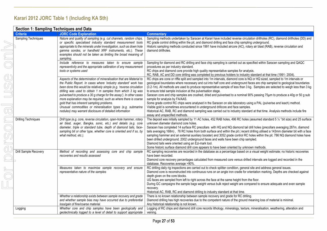
Karari 2012 JORC Table 1 (Including KA Sth)
Section 1: Sampling Techniques and Data Criteria JORC Code Explanation Commentary Sampling Techniques Nature and quality of sampling (e.g. cut channels, random chips,
or specific specialised industry standard measurement tools appropriate to the minerals under investigation, such as down hole gamma sondes, or handheld XRF instruments, etc.). These examples should not be taken as limiting the broad meaning of sampling.
Sampling methods undertaken by Saracen at Karari have included reverse circulation drillholes (RC), diamond drillholes (DD) and RC grade control drilling within the pit, and diamond drilling and face chip sampling underground. Historic sampling methods conducted since 1991 have included aircore (AC), rotary air blast (RAB), reverse circulation and diamond drillholes.
Include reference to measures taken to ensure sample representivity and the appropriate calibration of any measurement tools or systems used
Sampling for diamond and RC drilling and face chip sampling is carried out as specified within Saracen sampling and QAQC procedures as per industry standard. RC chips and diamond core provide high quality representative samples for analysis. RC, RAB, AC and DD core drilling was completed by previous holders to industry standard at that time (1991- 2004).
Aspects of the determination of mineralisation that are Material to the Public Report. In cases where ‘industry standard’ work has been done this would be relatively simple (e.g. ‘reverse circulation drilling was used to obtain 1 m samples from which 3 kg was pulverised to produce a 30 g charge for fire assay’). In other cases more explanation may be required, such as where there is coarse gold that has inherent sampling problems. Unusual commodities or mineralisation types (e.g. submarine nodules) may warrant disclosure of detailed information
RC chips are cone or riffle split and sampled into 1m intervals, diamond core is NQ or HQ sized, sampled to 1m intervals or geological boundaries where necessary and cut into half core and underground faces are chip sampled to geological boundaries (0.2-1m). All methods are used to produce representative sample of less than 3 kg. Samples are selected to weigh less than 3 kg to ensure total sample inclusion at the pulverisation stage. Saracen core and chip samples are crushed, dried and pulverised to a nominal 90% passing 75µm to produce a 40g or 50 g sub sample for analysis by FA/AAS. Some grade control RC chips were analysed in the Saracen on site laboratory using a PAL (pulverise and leach) method. Visible gold is sometimes encountered in underground drillcore and face samples. Historical AC, RAB, RC and diamond sampling was carried out to industry standard at that time. Analysis methods include fire assay and unspecified methods.
Drilling Techniques Drill type (e.g. core, reverse circulation, open-hole hammer, rotary air blast, auger, Bangka, sonic, etc.) and details (e.g. core diameter, triple or standard tube, depth of diamond tails, face-sampling bit or other type, whether core is oriented and if so, by what method, etc.).
The deposit was initially sampled by 11 AC holes, 452 RAB holes, 496 RC holes (assumed standard 5 ¼ ‘’bit size) and 25 surface unknown diameter diamond core holes. Saracen has completed 14 surface RC precollars with HQ and NQ diamond tail drill holes (precollars averaging 287m, diamond tails averaging 168m) , 76 RC holes from both surface and within the pit ( recent drilling utilised a 143mm diameter bit with a face sampling hammer and an external auxiliary booster) and 3052 grade control RC holes within the pit. 786 NQ diamond holes have been drilled underground. 2002 underground faces and walls have been chip sampled. Diamond tails were oriented using an Ezi-mark tool. Some historic surface diamond drill core appears to have been oriented by unknown methods.
Drill Sample Recovery Method of recording and assessing core and chip sample recoveries and results assessed
RC sampling recoveries are recorded in the database as a percentage based on a visual weight estimate; no historic recoveries have been recorded. Diamond core recovery percentages calculated from measured core versus drilled intervals are logged and recorded in the database. Recoveries average >90%.
Measures taken to maximise sample recovery and ensure representative nature of the samples
RC drilling daily rig inspections are carried out to check splitter condition, general site and address general issues. Diamond core is reconstructed into continuous runs on an angle iron cradle for orientation marking. Depths are checked against depth given on the core blocks. UG faces are sampled from left to right across the face at the same height from the floor. During GC campaigns the sample bags weight versus bulk reject weight are compared to ensure adequate and even sample recovery. Historical AC, RAB, RC and diamond drilling to industry standard at that time.
Whether a relationship exists between sample recovery and grade and whether sample bias may have occurred due to preferential loss/gain of fine/coarse material.
There is no known relationship between sample recovery and grade for RC drilling. Diamond drilling has high recoveries due to the competent nature of the ground meaning loss of material is minimal. Any historical relationship is not known.
Logging Whether core and chip samples have been geologically and geotechnically logged to a level of detail to support appropriate
Logging of RC chips and diamond drill core records lithology, mineralogy, texture, mineralisation, weathering, alteration and veining.
For
per
sona
l use
onl
y

Page 28 of 53
Section 1: Sampling Techniques and Data Criteria JORC Code Explanation Commentary
Mineral Resource estimation, mining studies and metallurgical studies. Whether logging is qualitative or quantitative in nature. Core (or costean, channel, etc) photography.
Geotechnical and structural logging is carried out on all diamond holes to record recovery, RQD, defect number, type, fill material, shape and roughness and alpha and beta angles. All faces are photographed and mapped. Chips from all RC holes (exploration and GC) are stored in chip trays for future reference while remaining core is stored in core trays and archived on site. Core is photographed in both dry and wet state. Qualitative and quantitative logging of historic data varies in its completeness.
The total length and percentage of the relevant intersections logged
All RC and diamond drillholes holes are logged in full and all faces are mapped. Every second drill line is logged in grade control programs with infill logging carried out as deemed necessary. Historical logging is approximately 95% complete.
Sub-sampling techniques and sample preparation
If core, whether cut or sawn and whether quarter, half or all core taken.
All drill core is cut in half onsite using an automatic core saw. Samples are always collected from the same side.
If non-core, whether riffled, tube sampled, rotary split, etc and whether sampled wet or dry.
All exploration and grade control RC samples are cone or riffle split. Occasional wet samples are encountered. Underground faces are chip sampled using a hammer. AC, RAB and RC drilling has been sampled using riffle and unknown methods.
For all sample types, the nature, quality and appropriateness of the sample preparation technique.
The sample preparation of diamond core and RC and underground face chips adhere to industry best practice. It is conducted by a commercial laboratory and involves oven drying, coarse crushing then total grinding to a size of 90% passing 75 microns. Best practice is assumed at the time of historic sampling.
Quality control procedures adopted for all sub-sampling stages to maximise representivity of samples.
All subsampling activities are carried out by commercial laboratory and are considered to be satisfactory. Sampling by previous holders assumed to be industry standard at the time.
Measures taken to ensure that the sampling is representative of the in situ material collected, including for instance results for field duplicate/second half sampling.
RC field duplicate samples are carried out at a rate of 1:20 and are sampled directly from the on-board splitter on the rig. These are submitted for the same assay process as the original samples and the laboratory are unaware of such submissions. No duplicates have been taken of underground core or face samples. Sampling by previous holders assumed to be industry standard at the time.
Whether sample sizes are appropriate to the grain size of the material being sampled.
Sample sizes of 3kg are considered to be appropriate given the grain size (90% passing 75 microns) of the material sampled.
Quality of assay data and laboratory tests
The nature, quality and appropriateness of the assaying and laboratory procedures used and whether the technique is considered partial or total.
RC chip samples, grade control chip samples, underground face chip samples and diamond core are analysed by external laboratories using a 40g or 50g fire assay with AAS finish. These methods are considered suitable for determining gold concentrations in rock and are total digest methods. Some GC samples were analysed in the Saracen onsite laboratory using pulverise and leach method. This method is a partial digest. Historic sampling includes fire assay and unknown methods.
For geophysical tools, spectrometers, handheld XRF instruments, etc, the parameters used in determining the analysis including instrument make and model, reading times, calibrations factors applied and their derivation, etc.
No geophysical tools have been utilised for reporting gold mineralisation.
Nature of quality control procedures adopted (e.g. standards, blanks, duplicates, external laboratory checks) and whether acceptable levels of accuracy (i.e. lack of bias) and precision have been established.
Certified reference material (standards and blanks) with a wide range of values are inserted into every drillhole at a rate of 1:25 for exploration RC and DD, and 1:40 for GC drilling. These are not identifiable to the laboratory. QAQC data returned are checked against pass/fail limits with the SQL database and are passed or failed on import. A report is generated and reviewed by the geologist as necessary upon failure to determine further action. QAQC data is reported monthly. Sample preparation checks for fineness are carried out to ensure a grindsize of 90% passing 75 microns. The laboratory performs a number of internal processes including standards, blanks, repeats and checks. QAQC data analysis demonstrates sufficient accuracy and precision. Industry best practice is assumed for previous holders.
Verification of sampling and assaying
The verification of significant intersections by either independent or alternative company personnel.
Significant intercepts are verified by the Geology Manager and corporate personnel.
For
per
sona
l use
onl
y

Page 29 of 53
Section 1: Sampling Techniques and Data Criteria JORC Code Explanation Commentary
The use of twinned holes. No specific twinned holes have been drilled at Karari but grade control drilling and underground diamond drilling has confirmed the width and grade of previous exploration drilling.
Documentation of primary data, data entry procedures, data verification, data storage (physical and electronic) protocols
Primary data is collated in a set of excel templates utilising lookup codes. This data is forwarded to the Database Administrator for entry into a secure acQuire database with inbuilt validation functions. Data from previous owners was taken from a database compilation and validated as much as practicable before entry into the Saracen acQuire database.
Discuss any adjustment to assay data. No adjustments have been made to assay data. First gold assay is utilised for resource estimation.
Location of data points Accuracy and quality of surveys used to locate drillholes (collar and down-hole surveys), trenches, mine workings and other locations used in Mineral Resource estimation.
Exploration drillholes are located using a Leica 1200 GPS with an accuracy of +/- 10mm. Drillhole collars within the pit and immediate surrounds are picked up by company surveyors using a Trimble R8 GNSS (GPS) with an expected accuracy of +/-8mm. All underground drillhole collars are picked up by company surveyors using a Leica TS15i (total station) with an expected accuracy of +/-2mm. Underground faces are located using a Leica D5 disto with and accuracy of +/- 1mm from a known survey point. Downhole surveys are carried out using the DeviFlex RAPID continuous inrod survey instrument taking readings every 5 seconds, In and Out runs and reported in 3m intervals, survey accuracy +-3:1000. A number of drillholes have also been gyroscopically surveyed. Previous holders’ survey accuracy and quality is unknown
Specification of the grid system used. A local grid system (Karari) is used. The two point conversion to MGA_GDA94 zone 51 is KAREast KARNorth RL MGAEast MGANorth RL Point 1 4000 8000 0 439359.94 6663787.79 0 Point 2 3000 7400 0 438359.84 6663187.72 0 Historic data is converted to the Karari local grid upon export from the database.
Quality and adequacy of topographic control. Topographic control originally used site based survey pickups in addition to Kevron aerial photogrammetric surveys with +/- 5m resolution. Pre mining, new and more detailed topography has since been captured and will be used in future updates and for subsequent planning purposes.
Data spacing and distribution Data spacing for reporting of Exploration Results. The nominal spacing for drilling is 25m x 25m.
Whether the data spacing and distribution is sufficient to establish the degree of geological and grade continuity appropriate for the Mineral Resource and Ore Reserve estimation procedure(s) and classifications applied.
Data spacing and distribution are sufficient to establish the degree of geological and grade continuity appropriate for JORC classifications applied.
Orientation of data in relation to geological structure
Whether sample compositing has been applied. Sample compositing is not applied until the estimation stage. Some historic RAB and RC sampling was composited into 3-4m samples with areas of interest re-sampled to 1m intervals. It is unknown at what threshold this occurred.
Whether the orientation of sampling achieves unbiased sampling of possible structures and the extent to which this is known, considering the deposit type.
The majority of drillholes are positioned to achieve optimum intersection angles to the ore zone as are practicable. Underground diamond drilling is designed to intersect the orebody in the best possible orientation given the constraints of underground drill locations. UG faces are sampled left to right across the face allowing a representative sample to be taken.
If the relationship between the drilling orientation and the orientation of key mineralised structures is considered to have introduced a sampling bias, this should be assessed and reported if material.
No significant sampling bias has been recognised due to orientation of drilling in regards to mineralised structures.
Sample security The measures taken to ensure sample security. Samples are prepared on site under supervision of Saracen geological staff. Samples are selected, bagged into tied numbered calico bags then grouped into secured cages and collected by the laboratory personnel. Sample submissions are documented via laboratory tracking systems and assays are returned via email
For
per
sona
l use
onl
y

Page 30 of 53
Section 1: Sampling Techniques and Data Criteria JORC Code Explanation Commentary Audits or reviews The results of any audits or reviews of sampling techniques and
data. An internal review of companywide sampling methodologies was conducted to create the current sampling and QAQC procedures. No external audits or reviews have been conducted.
Section 2: Reporting of Exploration Results Criteria JORC Code Explanation Commentary Mineral tenement and land tenure status
Type, reference name/number, location and ownership including agreements or material issues with third parties such as joint ventures, partnerships, overriding royalties, native title interests, historical sites, wilderness or national park and environmental settings.
The Karari pit is located on M28/166 and M28/167 Mining Leases M28/166 and M28/167 are held 100% by Saracen Gold Mines Pty Ltd a wholly owned subsidiary of Saracen Mineral Holdings Limited. Mining Leases M28/166 and M28/167 have a 21 year life (held until 2020) and are renewable for a further 21 years on a continuing basis. There are no registered Aboriginal Heritage sites within Mining Leases M28/166 and M28/167. M28/166 and M28/167 are the subject of the Maduwongga native title claim (WC2017/001). Mining Leases M28/166 and M28/167 are subject to two third party royalties payable on the tenements, a bank mortgage (Mortgage 499142) and two caveats (Caveat 51H/067 and 52H/067, respectively). All production is subject to a Western Australian state government NSR royalty of 2.5%. The tenements are subject to the Pinjin Pastoral Compensation Agreement. The Mining Rehabilitation Fund applies to the tenements.
The security of the tenure held at the time of reporting along with any known impediments to obtaining a licence to operate in the area.
The tenements are in good standing and the licence to operate already exists
Exploration done by other parties
Acknowledgment and appraisal of exploration by other parties. The Carosue Dam project area in which the Karari deposit is located has been subjected to extensive gold exploration by numerous companies since 1991. Karari was highlighted as an area of interest following an aeromagnetic survey conducted by CRA Exploration. Auger sampling of the target defined a widespread gold anomaly with follow up RAB drilling intersecting significant gold mineralisation. RC and DD drilling further defined the mineralisation before Aberfoyle entered into a joint venture agreement with CRA. Further drilling by Aberfoyle defined mineralisation over a 600m strike length. Aberfoyle were subject to a hostile takeover by Western Metals with PacMin then purchasing the Carosue Dam project. An intensive resource definition program consisting of both RC and DD drilling was carried out before mining of Karari commenced in 2000.
Geology Deposit type, geological setting and style of mineralisation.
The Karari deposit sits along the regional NNW-trending Keith-Kilkenny fault zone within the eastern edge of the Norseman-Wiluna greenstone belt. The deposit itself is lithologically and structurally controlled and sits within an altered volcaniclastic sandstone unit that has been offset along a series of major faults running NE-SW and NW-SE, as well as intruded by large lamprophyre units post mineralization. Mineralization is dominated by pyrite and hosted in broad hematite altered sandstone units with a central high grade siliceous core light-moderately dipping to the North.
For
per
sona
l use
onl
y

Page 31 of 53
Section 2: Reporting of Exploration Results Criteria JORC Code Explanation Commentary Drillhole information A summary of all information material to the
understanding of the exploration results including a tabulation of the following information for all Material drill holes:
easting and northing of the drill hole collar
elevation or RL (Reduced Level – elevation
above sea level in metres) of the drill hole collar
dip and azimuth of the hole
down hole length and interception depth
hole length.
If the exclusion of this information is justified on the basis that the information is not Material and this exclusion does not detract from the understanding of the report, the Competent Person should clearly explain why this is the case.
All material data is periodically released on the ASX: 31/07/2018, 01/05/2018,15/02/2018, 27/11/2017, 26/09/2017, 13/07/2017, 01/05/2017, 21/02/2017, 13/04/2016, 23/02/2016, 10/12/2015, 03/07/2015, 25/05/2015, 05/05/2015, 11/03/2015, 16/01/2014, 14/10/2013, 25/01/2013, 28/07/2011, 03/06/2011, 21/04/2011, 09/02/2011, 03/11/2008
Data aggregation methods In reporting Exploration Results, weighting averaging techniques, maximum and/or minimum grade truncations (e.g. cutting of high grades) and cut-off grades are usually Material and should be stated.
All underground diamond drillhole significant intercepts have been length weighted with a minimum Au grade of 2.5ppm. No high grade cut off has been applied.
Where aggregate intercepts incorporate short lengths of high grade results and longer lengths of low grade results, the procedure used for such aggregation should be stated and some typical examples of such aggregations should be shown in detail.
Intercepts are aggregated with minimum width of 0.5m and maximum width of 3m for internal dilution. Where stand out higher grade zone exist with in the broader mineralised zone, the higher grade interval is reported also.
The assumptions used for any reporting of metal equivalent values should be clearly stated.
There are no metal equivalents reported in this release.
Relationship between mineralisation widths and intercept lengths
These relationships are particularly important in the reporting of Exploration Results If the geometry of the mineralisation with respect to the drill hole angle is known, its nature should be reported. If it is not known and only the down hole lengths are reported, there should be a clear statement to this effect (e.g. ‘down hole length, true width not known’).
Previous announcements included sufficient detail to clearly illustrate the geometry of the mineralisation and the recent drilling. All results are reported as downhole lengths.
Diagrams Appropriate maps and sections (with scales) and tabulations of intercepts should be included for any significant discovery being reported These should include, but not be limited to a plan view of drill hole collar locations and appropriate sectional views.
No Diagrams are referenced in this release.
Balanced Reporting Where comprehensive reporting of all Exploration Results are not practicable, representative reporting of both low and high grades and/or widths should be practiced to avoid misleading reporting of Exploration Results.
All results from previous campaigns have been reported, irrespective of success or not.
For
per
sona
l use
onl
y

Page 32 of 53
Section 2: Reporting of Exploration Results Criteria JORC Code Explanation Commentary Other substantive exploration data
Other exploration data, if meaningful and material, should be reported including (but not limited to): geological observations; geophysical survey results; geochemical survey results; bulk samples – size and method of treatment; metallurgical test results; bulk density, groundwater, geotechnical and rock characteristics; potential deleterious or contaminating substances.
No substantive data acquisition has been completed in recent times.
Further work The nature and scale of planned further work (e.g. tests for lateral extensions or depth extensions or large-scale step-out drilling). Diagrams clearly highlighting the areas of possible extensions, including the main geological interpretations and future drilling areas, provided this information is not commercially sensitive
Further infill drilling may be carried out inside the reserve UG design to improve confidence. The drilling is getting to the depth where exploration is expensive and the approach needs to be carefully considered. Underground drilling continues and surface drilling is being evaluated. A seismic project is also being assessed.
Safari Bore JORC Table 1
Section 1: Sampling Techniques and Data Criteria JORC Code Explanation Commentary Sampling Techniques Nature and quality of sampling (e.g. cut channels,
random chips, or specific specialised industry standard measurement tools appropriate to the minerals under investigation, such as down hole gamma sondes, or handheld XRF instruments, etc.). These examples should not be taken as limiting the broad meaning of sampling.
Saracen has undertaken reverse circulation drilling (RC) at Safari Bore. Historic methods conducted since 1968 have included aircore (AC), rotary air blast (RAB), reverse circulation and diamond drillholes.
Include reference to measures taken to ensure sample representivity and the appropriate calibration of any measurement tools or systems used
Sampling for RC drilling is carried out as specified within Saracen sampling and QAQC procedures as per industry standard. RC chips provide high quality representative samples for analysis. RC, RAB, AC and DD core drilling was completed by previous holders to industry standard at that time (1968- 2004).
Aspects of the determination of mineralisation that are Material to the Public Report. In cases where ‘industry standard’ work has been done this would be relatively simple (e.g. ‘reverse circulation drilling was used to obtain 1 m samples from which 3 kg was pulverised to produce a 30 g charge for fire assay’). In other cases more explanation may be required, such as where there is coarse gold that has inherent sampling problems. Unusual commodities or mineralisation types (e.g. submarine nodules) may warrant disclosure of detailed information
RC chips are cone split and sampled into 1m intervals with total sample weights less than 3 kg. Samples are selected to weigh less than 3 kg to ensure total sample inclusion at the pulverisation stage. Saracen chip samples are crushed, dried and pulverised to a nominal 90% passing 75µm to produce a 50g sub sample for analysis by FA/AAS. Historical AC, RAB, RC and diamond sampling was carried out to industry standard at that time. Analysis methods include fire assay, aqua regia, atomic absorption spectroscopy and unspecified methods. F
or p
erso
nal u
se o
nly
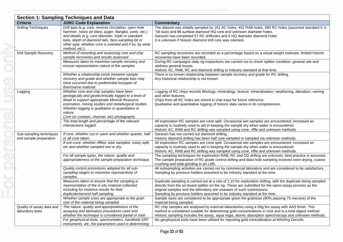
Page 33 of 53
Section 1: Sampling Techniques and Data Criteria JORC Code Explanation Commentary Drilling Techniques Drill type (e.g. core, reverse circulation, open-hole
hammer, rotary air blast, auger, Bangka, sonic, etc.) and details (e.g. core diameter, triple or standard tube, depth of diamond tails, face-sampling bit or other type, whether core is oriented and if so, by what method, etc.).
The deposit was initially sampled by 161 AC holes, 452 RAB holes, 690 RC holes (assumed standard 5 ¼ ‘’bit size) and 66 surface diamond HQ core and unknown diameter holes. Saracen has completed 57 RC drillholes and 5 HQ diameter diamond holes It is unknown if historic diamond drill core was oriented.
Drill Sample Recovery Method of recording and assessing core and chip sample recoveries and results assessed
RC sampling recoveries are recorded as a percentage based on a visual weight estimate; limited historic recoveries have been recorded.
Measures taken to maximise sample recovery and ensure representative nature of the samples
During RC campaigns daily rig inspections are carried out to check splitter condition, general site and address general issues. Historic AC, RAB, RC and diamond drilling to industry standard at that time.
Whether a relationship exists between sample recovery and grade and whether sample bias may have occurred due to preferential loss/gain of fine/coarse material.
There is no known relationship between sample recovery and grade for RC drilling. Any historical relationship is not known.
Logging Whether core and chip samples have been geologically and geotechnically logged to a level of detail to support appropriate Mineral Resource estimation, mining studies and metallurgical studies. Whether logging is qualitative or quantitative in nature. Core (or costean, channel, etc) photography.
Logging of RC chips records lithology, mineralogy, texture, mineralisation, weathering, alteration, veining and other features. Chips from all RC holes are stored in chip trays for future reference. Qualitative and quantitative logging of historic data varies in its completeness.
The total length and percentage of the relevant intersections logged
All exploration RC samples are cone split. Occasional wet samples are encountered; increased air capacity is routinely used to aid in keeping the sample dry when water is encountered. Historic AC, RAB and RC drilling was sampled using cone, riffle and unknown methods.
Sub-sampling techniques and sample preparation
If core, whether cut or sawn and whether quarter, half or all core taken.
Saracen has not carried out diamond drilling. Historic diamond drilling has been half core sampled or sampled via unknown methods.
If non-core, whether riffled, tube sampled, rotary split, etc and whether sampled wet or dry.
All exploration RC samples are cone split. Occasional wet samples are encountered; increased air capacity is routinely used to aid in keeping the sample dry when water is encountered. Historic AC, RAB and RC drilling was sampled using cone, riffle and unknown methods.
For all sample types, the nature, quality and appropriateness of the sample preparation technique.
The sampling techniques for exploration RAB, RC and DD drilling are unknown, best practice is assumed. The sample preparation of RC grade control drilling and blast hole sampling involved oven drying, coarse crushing and total grinding in an LM5.
Quality control procedures adopted for all sub-sampling stages to maximise representivity of samples.
All subsampling activities are carried out by commercial laboratory and are considered to be satisfactory. Sampling by previous holders assumed to be industry standard at the time.
Measures taken to ensure that the sampling is representative of the in situ material collected, including for instance results for field duplicate/second half sampling.
Duplicate sampling is carried out at a rate of 1:10 for exploration drilling, with the duplicate being sampled directly from the on-board splitter on the rig. These are submitted for the same assay process as the original samples and the laboratory are unaware of such submissions. Sampling by previous holders assumed to be industry standard at the time.
Whether sample sizes are appropriate to the grain size of the material being sampled.
Sample sizes are considered to be appropriate given the grainsize (90% passing 75 microns) of the material being sampled.
Quality of assay data and laboratory tests
The nature, quality and appropriateness of the assaying and laboratory procedures used and whether the technique is considered partial or total.
RC chip samples are analysed by external laboratories using a 50g fire assay with AAS finish. This method is considered suitable for determining gold concentrations in rock and is a total digest method. Historic sampling includes fire assay, aqua regia, atomic absorption spectroscopy and unknown methods.
For geophysical tools, spectrometers, handheld XRF instruments, etc, the parameters used in determining
No geophysical tools have been utilised for reporting gold mineralisation at Whirling Dervish.
For
per
sona
l use
onl
y

Page 34 of 53
Section 1: Sampling Techniques and Data Criteria JORC Code Explanation Commentary
the analysis including instrument make and model, reading times, calibrations factors applied and their derivation, etc.
Nature of quality control procedures adopted (e.g. standards, blanks, duplicates, external laboratory checks) and whether acceptable levels of accuracy (i.e. lack of bias) and precision have been established.
Certified reference material (standards and blanks) with a wide range of values are inserted into every drillhole at a rate of 1:25 for exploration RC drilling. These are not identifiable to the laboratory. QAQC data returned are checked against pass/fail limits with the SQL database and are passed or failed on import. A report is generated and reviewed by the geologist as necessary upon failure to determine further action. QAQC data is reported monthly. Sample preparation checks for fineness are carried out to ensure a grindsize of 90% passing 75 microns. The laboratory performs a number of internal processes including standards, blanks, repeats and checks. QAQC data analysis demonstrates sufficient accuracy and precision. Industry best practice is assumed for previous holders.
Verification of sampling and assaying
The verification of significant intersections by either independent or alternative company personnel.
Significant intercepts are verified by the Geology Manager and corporate personnel.
The use of twinned holes. No specific twinned holes have been drilled at Safari Bore.
Documentation of primary data, data entry procedures, data verification, data storage (physical and electronic) protocols
Primary data is collated in a set of excel templates utilising lookup codes. This data is forwarded to the Database Administrator for entry into a secure acQuire database with inbuilt validation functions. Data from previous owners was taken from a database compilation and validated as much as practicable before entry into the Saracen acQuire database.
Discuss any adjustment to assay data. No adjustments have been made to assay data. First gold assay is utilised for resource estimation.
Location of data points Accuracy and quality of surveys used to locate drillholes (collar and down-hole surveys), trenches, mine workings and other locations used in Mineral Resource estimation.
Exploration drillholes are located using a Leica 1200 GPS with an accuracy of +/- 10mm. Downhole surveys are carried out using an Eastman single shot camera at regular intervals (usually 30m). Previous holders’ survey accuracy and quality is unknown
Specification of the grid system used. A local grid system (Safari Bore) is used. The two point conversion to MGA_GDA94 zone 51 is SBEast SBNorth RL MGAEast MGANorth RL Point 1 51000 34000 0 451137.753 6734157.921 0 Point 2 51000 30000 0 451137.890 6730157.896 0 Historic data is converted to the Safari Bore local grid upon export from the database.
Quality and adequacy of topographic control. Topographic control originally used site based survey pickups in addition to Kevron aerial photogrammetric surveys with +/- 5m resolution. Pre mining, new and more detailed topography has since been captured and will be used in future updates and for subsequent planning purposes.
Data spacing and distribution
Data spacing for reporting of Exploration Results. The nominal spacing for exploration drilling ranges from 20 m x 20 m
Whether the data spacing and distribution is sufficient to establish the degree of geological and grade continuity appropriate for the Mineral Resource and Ore Reserve estimation procedure(s) and classifications applied.
Data spacing and distribution are sufficient to establish the degree of geological and grade continuity appropriate for JORC classifications applied.
Orientation of data in relation to geological structure
Whether sample compositing has been applied.
Sample compositing is not applied until the estimation stage. Some historic RAB and RC sampling was composited into 3-4m samples with areas of interest re-sampled to 1m intervals. It is unknown at what threshold this occurred.
For
per
sona
l use
onl
y

Page 35 of 53
Section 1: Sampling Techniques and Data Criteria JORC Code Explanation Commentary
Whether the orientation of sampling achieves unbiased sampling of possible structures and the extent to which this is known, considering the deposit type.
The majority of drillholes are positioned to achieve optimum intersection angles to the ore zone as are practicable.
If the relationship between the drilling orientation and the orientation of key mineralised structures is considered to have introduced a sampling bias, this should be assessed and reported if material.
No significant sampling bias is thought to occur due to orientation of drilling in regards to mineralised structures.
Sample security The measures taken to ensure sample security. Samples are prepared on site under supervision of Saracen geological staff. Samples are selected, bagged into tied numbered calico bags then grouped into secured cages and collected by the laboratory personnel. Sample submissions are documented via laboratory tracking systems and assays are returned via email
Audits or reviews The results of any audits or reviews of sampling techniques and data.
An internal review of companywide sampling methodologies was conducted to create the current sampling and QAQC procedures.
Section 2: Reporting of Exploration Results Criteria JORC Code Explanation Commentary Mineral tenement and land tenure status
Type, reference name/number, location and ownership including agreements or material issues with third parties such as joint ventures, partnerships, overriding royalties, native title interests, historical sites, wilderness or national park and environmental settings.
The Safari Bore resource is located on M39/307. Near mine exploration extends onto M39/639. The tenements are held 100% by Saracen Gold Mines Pty Ltd, a wholly owned subsidiary of Saracen Mineral Holdings Limited. Mining Leases M39/307 have a 21 year life (held until 2015 and 2024, respectively). The tenements are renewable for a further 21 years on a continuing basis. Mining Leases M39/307 and M39/639 are each subject to one royalty agreement and one associated caveat (144H/067 and 150H/067, respectively). M39/307 is subject to a bank mortgage (415495). All production is subject to a Western Australian state government NSR royalty of 2.5%. Mining Leases M39/307 and M39/639 are subject to the Edjudina Pastoral Compensation Agreement. M39/307 is subject to the Yundamindera Pastoral Compensation Agreement. There are no registered Aboriginal Heritage sites within M39/307 and M39/639.
The security of the tenure held at the time of reporting along with any known impediments to obtaining a licence to operate in the area.
The tenements are in good standing and there are no known impediments to obtaining a licence to operate.
Exploration done by other parties
Acknowledgment and appraisal of exploration by other parties.
Unsuccessful nickel exploration was carried out in the Mount Celia project area in which Safari Bore is located in the 1960’s and 1970’s. Pancontinental Mining pegged the ground in 1988 and began gold exploration beginning with a soil geochemistry survey (deemed ineffective due to depth of cover) followed by regional RAB then targeted RC drilling of anomalous areas. Further RC and diamond drilling was carried out to define the Safari Bore resource. PanCon entered into a joint venture with Goldfields in 1995. Extensive regional RAB and RC drilling were carried out along with RC and diamond resource infill drilling. Sons of Gwalia purchased the project from Goldfields in 2001 and completed further regional RAB and RC drilling along with resource definition RC and diamond drilling before mining commenced in 2003. St Barbara acquired the project following the collapse of Sons of Gwalia. No further exploration activities took place and mining operations were suspended in 2005.
Geology Deposit type, geological setting and style of mineralisation.
The Safari Bore deposit is located within the eastern part of the Norseman-Wiluna greenstone belt in the Eastern Goldfields province of the Archaean Yilgarn Craton.
For
per
sona
l use
onl
y

Page 36 of 53
Section 2: Reporting of Exploration Results Criteria JORC Code Explanation Commentary
The deposit sits within the Pinjin fault, a major NNW trending regional lineament and comprises a sub vertically WSW dipping NNW striking package of intensely deformed and altered intermediate to mafic intrusive and extrusive rocks and sediments intruded by felsic porphyry. Mineralisation within this sequence occurs in multiple structural and lithological settings, in four discreet lodes (red, green, purple and Serengeti), all associated with quartz-carbonate-albite hydraulic breccia veins. Serengeti and red lodes lie within the margins of gently southerly plunging felsic porphyry. Green and purple lodes are sub vertical sheets oriented sub-parallel to foliation.
Drillhole information A summary of all information material to the understanding of the exploration results including a tabulation of the following information for all Material drill holes:
easting and northing of the drill hole collar
elevation or RL (Reduced Level – elevation
above sea level in metres) of the drill hole collar
dip and azimuth of the hole
down hole length and interception depth
hole length.
If the exclusion of this information is justified on the basis that the information is not Material and this exclusion does not detract from the understanding of the report, the Competent Person should clearly explain why this is the case.
All significant exploration results released by Saracen are documented in ASX statements.
Data aggregation methods
In reporting Exploration Results, weighting averaging techniques, maximum and/or minimum grade truncations (e.g. cutting of high grades) and cut-off grades are usually Material and should be stated.
All significant intercepts have been length weighted with a minimum Au grade of 1ppm. No high grade cut off has been applied.
Where aggregate intercepts incorporate short lengths of high grade results and longer lengths of low grade results, the procedure used for such aggregation should be stated and some typical examples of such aggregations should be shown in detail.
Intercepts are aggregated with minimum width of 1m and maximum width of 3m for internal dilution. Where stand out higher grade zone exist with in the broader mineralised zone, the higher grade interval is reported also.
The assumptions used for any reporting of metal equivalent values should be clearly stated.
Metal equivalent values are not reported
Relationship between mineralisation widths and intercept lengths
These relationships are particularly important in the reporting of Exploration Results. If the geometry of the mineralisation with respect to the drill hole angle is known, its nature should be reported. If it is not known and only the down hole lengths are reported, there should be a clear statement to this effect (eg ‘down hole length, true width not known’).
There are no exploration results to report with this document.
Diagrams Appropriate maps and sections (with scales) and tabulations of intercepts should be included for any significant discovery being reported These should
All significant exploration results released by Saracen are accompanied by the appropriate diagrams and maps at the time of the release.
For
per
sona
l use
onl
y

Page 37 of 53
Section 2: Reporting of Exploration Results Criteria JORC Code Explanation Commentary
include, but not be limited to a plan view of drill hole collar locations and appropriate sectional views.
Balanced Reporting Where comprehensive reporting of all Exploration Results are not practicable, representative reporting of both low and high grades and/or widths should be practiced to avoid misleading reporting of Exploration Results.
All results from the recent campaign have been reported, irrespective of success or not
Other substantive exploration data
Other exploration data, if meaningful and material, should be reported including (but not limited to): geological observations; geophysical survey results; geochemical survey results; bulk samples – size and method of treatment; metallurgical test results; bulk density, groundwater, geotechnical and rock characteristics; potential deleterious or contaminating substances.
No substantive data acquisition has been completed in recent times.
Further work The nature and scale of planned further work (eg tests for lateral extensions or depth extensions or large-scale step-out drilling). Diagrams clearly highlighting the areas of possible extensions, including the main geological interpretations and future drilling areas, provided this information is not commercially sensitive
Safari Bore is currently under review and exploration targeting will focus on areas with economic gain.
Otto Bore JORC Table 1
Section 1: Sampling Techniques and Data
Criteria JORC Code Explanation Commentary
Sampling Techniques Nature and quality of sampling (e.g. cut channels, random chips, or specific specialised industry standard measurement tools appropriate to the minerals under investigation, such as down hole gamma sondes, or handheld XRF instruments, etc.). These examples should not be taken as limiting the broad meaning of sampling.
Sampling methods undertaken by Saracen at Otto Bore include reverse circulation (RC) and diamond (DD) drillholes Sampling methods undertaken at Otto Bore by previous owners have included aircore (AC), rotary air blast (RAB), RC and diamond drillholes (DD).
Include reference to measures taken to ensure sample representivity and the appropriate calibration of any measurement tools or systems used
Sampling for diamond and RC drilling is carried out as specified within Saracen sampling and QAQC procedures as per industry standard. AC, RC, RAB, and DD core drilling is assumed to have been completed by previous holders to industry standard at that time (1988- 2012).
Aspects of the determination of mineralisation that are Material to the Public Report. In cases where ‘industry standard’ work has been done this would be relatively simple (e.g. ‘reverse circulation drilling was used to obtain
RC chips are cone split and sampled into 1m intervals with total sample weights under 3kg. Diamond core is HQ sized, sampled to 1m intervals or geological boundaries where necessary and cut into half core to give sample weights under 3 kg. Samples are selected to weigh less than 3 kg to ensure total sample inclusion at the pulverisation stage.
For
per
sona
l use
onl
y

Page 38 of 53
Section 1: Sampling Techniques and Data
Criteria JORC Code Explanation Commentary
1 m samples from which 3 kg was pulverised to produce a 30 g charge for fire assay’). In other cases more explanation may be required, such as where there is coarse gold that has inherent sampling problems. Unusual commodities or mineralisation types (e.g. submarine nodules) may warrant disclosure of detailed information
Saracen core and chip samples are crushed, dried and pulverised to a nominal 90% passing 75µm to produce a 40g sub sample for analysis by FA/AAS. Limited information has been found for historic drilling so it is assumed all AC, RAB, RC and DD and sampling was carried out to industry standard at that time. More recent RAB and RC drilling has involved a total preparation sample protocol involving 4m composite or 1m samples from which a 50g charge is produced for aqua regia or fire assay digest and flame AAS finish.
Drilling Techniques Drill type (e.g. core, reverse circulation, open-hole hammer, rotary air blast, auger, Bangka, sonic, etc.) and details (e.g. core diameter, triple or standard tube, depth of diamond tails, face-sampling bit or other type, whether core is oriented and if so, by what method, etc.).
Drilling activities at Otto Bore have included 31 AC holes, 748 RAB holes, 141 RC holes (assumed standard 5 ¼’’ bit size) and 4 DD holes (HQ and unknown diameter). Limited historic diamond core hole was oriented by unknown methods. Saracen completed 96 RC holes and 6 geotechnical DD holes. The RC drilling was completed with a 5.5 inch diameter bit with a face sampling hammer. The rig was equipped with an external auxiliary booster. Diamond drilling was HQ sized and orientated using an ACT 11 core orientation tool. Historical drilling is assumed completed to industry standard at that time
Drill Sample Recovery Method of recording and assessing core and chip sample recoveries and results assessed
Recoveries for RC drillholes and precollars are recorded as a percentage based on a visual weight estimate.
Measures taken to maximise sample recovery and ensure representative nature of the samples
During RC drilling daily rig inspections are carried out to check splitter condition, general site and address general issues. Measures were taken to supress groundwater.
Whether a relationship exists between sample recovery and grade and whether sample bias may have occurred due to preferential loss/gain of fine/coarse material.
There is no known relationship between sample recovery and grade for RC drilling. Diamond drilling has high recoveries meaning loss of material is minimal. Any historical relationship is not known.
Logging Whether core and chip samples have been geologically and geotechnically logged to a level of detail to support appropriate Mineral Resource estimation, mining studies and metallurgical studies. Whether logging is qualitative or quantitative in nature. Core (or costean, channel, etc) photography.
Logging of RC chips and DD core records lithology, mineralogy, texture, mineralisation, weathering, alteration and veining. Geotechnical and structural logging is carried out on all diamond holes to record recovery, RQD, defect number, type, fill material, shape and roughness and alpha and beta angles. Chips from all RC holes are stored in chip trays for future reference while remaining core is stored in core trays and archived on site. Some historic diamond drilling has had limited geotechnical logging carried out. Core has been photographed in both dry and wet state. It is unknown if historic diamond core was photographed. It is unknown if any historic diamond core was photographed.
The total length and percentage of the relevant intersections logged
All drillholes completed by Saracen have been logged in full.
Sub-sampling techniques and sample preparation
If core, whether cut or sawn and whether quarter, half or all core taken.
All drill core is cut in half onsite using an automatic core saw. Samples are always collected from the same side. The sampling method for most historic drill core is unknown, a small amount is recorded as half core sampled.
If non-core, whether riffled, tube sampled, rotary split, etc and whether sampled wet or dry.
All exploration RC samples are cone split. Occasional wet samples are encountered. The sampling methods for much of the historic AC, RC and RAB drilling are unknown. More recent RC and RAB drilling has been riffle split or spear sampled. It is unknown if wet samples were encountered.
For all sample types, the nature, quality and appropriateness of the sample preparation technique.
The sample preparation of RC chips and DD core adhere to industry best practice. It is conducted by a commercial laboratory and involves oven drying, coarse crushing then total grinding to a size of 90% passing 75 microns. The sampling techniques for much of the historic AC, RAB, RC and DD drilling are unknown, best practice is assumed.
For
per
sona
l use
onl
y

Page 39 of 53
Section 1: Sampling Techniques and Data
Criteria JORC Code Explanation Commentary
Quality control procedures adopted for all sub-sampling stages to maximise representivity of samples.
All subsampling activities are carried out by commercial laboratory and are considered to be satisfactory Best practice is assumed at the time of historic AC, RAB, DD and RC sampling.
Measures taken to ensure that the sampling is representative of the in situ material collected, including for instance results for field duplicate/second half sampling.
RC field duplicate samples are carried out at a rate of 1:20 and are sampled directly from the on-board splitter on the rig. These are submitted for the same assay process as the original samples and the laboratory are unaware of such submissions. It is unknown if duplicate sampling was performed on the majority of historic AC, RAB, RC and DD drilling. There is evidence of field duplicate sampling being conducted in more recent campaigns.
Whether sample sizes are appropriate to the grain size of the material being sampled.
Analysis of data determined sample sizes were considered to be appropriate.
Quality of assay data and laboratory tests
The nature, quality and appropriateness of the assaying and laboratory procedures used and whether the technique is considered partial or total.
RC chip and DD core samples are analysed by an external laboratory using a 40g fire assay with AAS finish. This method is considered suitable for determining gold concentrations in rock and is a total digest method. Numerous assay techniques have been used in the history of the deposit, most commonly fire assay, fire assay with flame finish and aqua regia. These methods are considered suitable for determining gold concentrations in rock and are total digest methods. Other assay methods utilised for gold determination include BETA, atomic absorption spectrometry and unknown methods.
For geophysical tools, spectrometers, handheld XRF instruments, etc, the parameters used in determining the analysis including instrument make and model, reading times, calibrations factors applied and their derivation, etc.
It is unknown if any instruments of this nature have been used at Otto Bore.
Nature of quality control procedures adopted (e.g. standards, blanks, duplicates, external laboratory checks) and whether acceptable levels of accuracy (i.e. lack of bias) and precision have been established.
Certified reference material (standards and blanks) with a wide range of values are inserted into every drillhole at a rate of 1:25 for exploration RC and DD. These are not identifiable to the laboratory. QAQC data returned are checked against pass/fail limits with the SQL database and are passed or failed on import. A report is generated and reviewed by the geologist as necessary upon failure to determine further action. QAQC data is reported monthly. Sample preparation checks for fineness are carried out to ensure a grindsize of 90% passing 75 microns. The laboratory performs a number of internal processes including standards, blanks, repeats and checks. QAQC data analysis demonstrates sufficient accuracy and precision. Industry best practice is assumed for previous holders.
Verification of sampling and assaying
The verification of significant intersections by either independent or alternative company personnel.
Significant intercepts are verified by the Geology Manager and corporate personnel
The use of twinned holes. Specific drilling programs consisting of twinned holes are not apparent.
Documentation of primary data, data entry procedures, data verification, data storage (physical and electronic) protocols
Primary data is collated in a set of excel templates utilising lookup codes. This data is forwarded to the Database Administrator for entry into a secure acQuire database with inbuilt validation functions. Data from previous owners was taken from a database compilation and validated as much as practicable before entry into the Saracen acQuire database
Discuss any adjustment to assay data. No adjustment to assay data appears to have been made
Location of data points Accuracy and quality of surveys used to locate drillholes (collar and down-hole surveys), trenches, mine workings and other locations used in Mineral Resource estimation.
Exploration drillholes are located using a Leica 1200 GPS with an accuracy of +/- 10mm. Downhole surveys are carried out using a hired Reflex EZ-gyro by the respective drilling companies on a regular basis, between 10-30m. The survey quality and control is unknown for the majority of historic drilling. More recent drilling has collar locations surveyed by unspecified GPS and DGPS equipment.
For
per
sona
l use
onl
y

Page 40 of 53
Section 1: Sampling Techniques and Data
Criteria JORC Code Explanation Commentary
Downhole survey methods recorded include Eastman single and multishot, gyro, inferred and unknown methods.
Specification of the grid system used. MGA Zone 51 grid coordinate system is used. Some historic data drilled on local grid systems has been converted to this grid system
Quality and adequacy of topographic control. Digital ortho-imagery of the area from Kevron Aerial Surveys was used in the early 2000s to establish topographic control.
Data spacing and distribution
Data spacing for reporting of Exploration Results. No exploration results reported in this release. The nominal drillhole spacing is 20 m (northing) by 20 m (easting) in the core of the deposit, and increases to the margins of the deposit.
Whether the data spacing and distribution is sufficient to establish the degree of geological and grade continuity appropriate for the Mineral Resource and Ore Reserve estimation procedure(s) and classifications applied.
The mineralised domains at Otto Bore have demonstrated sufficient continuity in both geological and grade continuity to support the definition of Mineral Resources, and the classifications applied under the 2012 JORC Code.
Orientation of data in relation to geological structure
Whether sample compositing has been applied.
No sample composting has been carried out Historic 1990s RAB and RC drilling was generally sampled on 3 - 4m composites with significant gold results being resampled in 1m intervals Some more recent RAB and RC drilling was composited into 4m samples with any assay >250ppb, or >500ppb in resource definition programs, resampled to 1m.
Whether the orientation of sampling achieves unbiased sampling of possible structures and the extent to which this is known, considering the deposit type.
The deposit is drilled towards grid east at angles varying from -600 and -900 to intersect the mineralised zones at a close to perpendicular relationship for the bulk of the deposit.
If the relationship between the drilling orientation and the orientation of key mineralised structures is considered to have introduced a sampling bias, this should be assessed and reported if material.
All drilling from surface has been drilled as close to perpendicular as possible. This has reduced the risk of introducing a sampling bias as far as possible. No orientation based sampling bias has been identified at Otto Bore in the data at this point.
Sample security The measures taken to ensure sample security. Samples are prepared on site under supervision of Saracen geological staff. Samples are selected, bagged into tied numbered calico bags then grouped into secured cages and collected by the laboratory personnel. Sample submissions are documented via laboratory tracking systems and assays are returned via email
Audits or reviews The results of any audits or reviews of sampling techniques and data.
An internal review of companywide sampling methodologies was conducted to create the current sampling and QAQC procedures. No external audits or reviews have been conducted
Section 2: Reporting of Exploration Results
Criteria JORC Code Explanation Commentary
Mineral tenement and land tenure status
Type, reference name/number, location and ownership including agreements or material issues with third parties such as joint ventures, partnerships, overriding royalties, native title interests, historical sites, wilderness or national park and environmental settings.
The Otto Bore resource is located on M36/421, M36/462, and M36/177. The mining leases have a 21 year life: M36/462 is held until 2022, M36/421 is held until 2023, and Mining Lease M36/177 is held until 2032. All are renewable for a further 21 years on a continuing basis. Mining Leases M36/421 and M36/462 are currently held by Saracen Metals Pty Limited (90%) and Black Mountain Gold NL (10%). The tenements are the subject of a purchase agreement with Saracen Metals Pty Limited whereby Saracen purchased a 90% share of the tenements from Norilsk Nickel Wildara Pty Ltd and Dalrymple Resources Pty Ltd. Mining Lease M36/462 is subject to a joint venture agreement (Agreement 127H/012 (129675)) between Oresearch NL, Dalrymple Resources NL, and Black Mountain Gold NL, as assigned to Saracen Metals Pty Limited at the time of purchase.
For
per
sona
l use
onl
y

Page 41 of 53
Section 2: Reporting of Exploration Results
Criteria JORC Code Explanation Commentary
Mining Lease M36/177 is held by Saracen Metals Pty Limited (67.8%) and Agnew Gold Mining Company Pty Ltd (32.2%). The tenement is the subject of a purchase agreement between Norilsk Nickel Wildara Pty Ltd and Saracen Metals Pty Limited whereby Saracen has purchased the 67.8% share from Norilsk. Mining Lease M36/177 is the subject of a joint venture agreement (Agreement 163H/945 (104991)) between Plutonic Operations Ltd and Black Mountain Gold NL, as assigned to Saracen Metals Pty Limited at the time of purchase. There are no caveats relating to the tenements. All production is subject to a Western Australian state government NSR royalty of 2.5%. Tenement M36/462 is subject to a Westpac Mortgage (499141). All tenements are subject to a pastoral compensation agreement between Saracen Metals Pty Ltd and Weebo Station. There are no native title claims over the tenements. There is a newly identified Aboriginal Heritage on M36/462 that is yet to be confirmed and registered by an Anthropologist.
The security of the tenure held at the time of reporting along with any known impediments to obtaining a licence to operate in the area.
No known impediment to obtaining a licence to operate exists and the remainder of the tenements are in good standing.
Exploration done by other parties
Acknowledgment and appraisal of exploration by other parties.
Gold exploration was conducted near Otto Bore in the 1950s following the discovery of the nearby Goanna Patch mineralisation. Nippon picked up the ground to the north of Otto Bore in the late 1980s and intersected anomalous zones at the Otto Bore prospect, but mineralisation was not deemed extensive enough. Otto Bore was discovered by Kismet in 1990 after they followed up regional RAB traverses at Goanna Patch and encountered mineralisation. It was deemed not large enough for consideration. Leader Resources picked up the area and completed RAB drilling before also deeming the area not worthy of follow up. They did however mine the nearby Double A open cut between March 1990 and May 1991 and concentrated much of the exploration in this area. Forrestania and LionOre entered into a JV on the area in the early 2000s. RAB drilling following up anomalous values from historic drilling intersected mineralisation and was followed up with RC and DD drilling and the Otto Bore resource was defined. Norilsk acquired the deposit but conducted no further exploration in the Otto Bore region.
Geology Deposit type, geological setting and style of mineralisation.
The Otto Bore mineralised deposit is situated within a complex sequence of sheared basalts and felsic volcaniclastics. To north ultramafics occur as part of the stratigraphy. At depth mineralisation is typically associated with quartz veining and is more strongly developed at the rheological boundary between the sheared complex and the hangingwall and footwall units. The shear zone strikes roughly north-south and dips moderately (50-60degrees) to the west. NW trending structures cross cut the main shear and interplay positively with gold mineralisation. It is hypothesised that it’s the interaction of these cross cutting structures and/or the folded network within the shear zone that defines the well delineated southerly plunging shoots. Mineralisation has been well tested along a strike length of 650m.
Drillhole information A summary of all information material to the understanding of the exploration results including a tabulation of the following information for all Material drill holes:
easting and northing of the drill hole collar
elevation or RL (Reduced Level – elevation
A total 253 holes have been used in the mineral resource and are deemed to be material. It is not practical to summarise all of the holes here in this release. All material data is periodically released on the ASX: 18/02/2019, 01/05/2018 Exclusion of the drilling information will not detract from the reader’s view of the report.
For
per
sona
l use
onl
y

Page 42 of 53
Section 2: Reporting of Exploration Results
Criteria JORC Code Explanation Commentary
above sea level in metres) of the drill hole collar
dip and azimuth of the hole
down hole length and interception depth
hole length.
If the exclusion of this information is justified on the basis that the information is not Material and this exclusion does not detract from the understanding of the report, the Competent Person should clearly explain why this is the case.
Data aggregation methods In reporting Exploration Results, weighting averaging techniques, maximum and/or minimum grade truncations (e.g. cutting of high grades) and cut-off grades are usually Material and should be stated.
All significant intercepts have been length weighted with a minimum Au grade of 0.5ppm. No high grade cut off has been applied.
Where aggregate intercepts incorporate short lengths of high grade results and longer lengths of low grade results, the procedure used for such aggregation should be stated and some typical examples of such aggregations should be shown in detail.
Intercepts are aggregated with minimum width of 1m and maximum width of 3m for internal dilution.
The assumptions used for any reporting of metal equivalent values should be clearly stated.
There are no metal equivalents reported in this release.
Relationship between mineralisation widths and intercept lengths
These relationships are particularly important in the reporting of Exploration Results. If the geometry of the mineralisation with respect to the drill hole angle is known, its nature should be reported. If it is not known and only the down hole lengths are reported, there should be a clear statement to this effect (e.g. ‘down hole length, true width not known’).
Previous announcements included sufficient detail to clearly illustrate the geometry of the mineralisation and the recent drilling. All results are reported as downhole lengths.
Diagrams Appropriate maps and sections (with scales) and tabulations of intercepts should be included for any significant discovery being reported These should include, but not be limited to a plan view of drill hole collar locations and appropriate sectional views.
No diagrams are referenced in this release.
Balanced Reporting Where comprehensive reporting of all Exploration Results are not practicable, representative reporting of both low and high grades and/or widths should be practiced to avoid misleading reporting of Exploration Results.
All results from the recent campaign have been reported, irrespective of success or not.
Other substantive exploration data
Other exploration data, if meaningful and material,should be reported including (but not limited to): geological observations; geophysical survey results geochemical survey results; bulk samples – size and method of treatment; metallurgical test results; bulk density,
Geophysical surveys including aeromagnetics and gravity have been carried out by previous owners to highlight and interpret prospective structures in the project area.
For
per
sona
l use
onl
y

Page 43 of 53
Section 2: Reporting of Exploration Results
Criteria JORC Code Explanation Commentary
groundwater, geotechnical and rock characteristics; potential deleterious or contaminating substances.
Further work The nature and scale of planned further work (e.g. tests for lateral extensions or depth extensions or large-scale step-out drilling). Diagrams clearly highlighting the areas of possible extensions, including the main geological interpretations and future drilling areas, provided this information is not commercially sensitive
Saracen is currently exploring proximal to the Otto Bore deposit and is working on an exploration program which will test the lateral and down dip extents of the Otto Bore mineral resource.
Atbara (Greater Luvironza) JORC Table 1
Section 1: Sampling Techniques and Data Criteria JORC Code Explanation Commentary Sampling Techniques Nature and quality of sampling (e.g. cut channels, random chips,
or specific specialised industry standard measurement tools appropriate to the minerals under investigation, such as down hole gamma sondes, or handheld XRF instruments, etc.). These examples should not be taken as limiting the broad meaning of sampling.
Sampling methods undertaken by Saracen at Greater Luvironza has consisted of reverse circulation (RC) drilling. Historic methods conducted since 1993 have included aircore (AC), rotary air blast (RAB), reverse circulation and diamond drillholes.
Include reference to measures taken to ensure sample representivity and the appropriate calibration of any measurement tools or systems used
Sampling for RC drilling is carried out as specified within Saracen sampling and QAQC procedures as per industry standard. RC chips provide high quality representative samples for analysis. RC, RAB, AC and DD core drilling was completed by previous holders to industry standard at that time (1993- 2002).
Aspects of the determination of mineralisation that are Material to the Public Report. In cases where ‘industry standard’ work has been done this would be relatively simple (e.g. ‘reverse circulation drilling was used to obtain 1 m samples from which 3 kg was pulverised to produce a 30 g charge for fire assay’). In other cases more explanation may be required, such as where there is coarse gold that has inherent sampling problems. Unusual commodities or mineralisation types (e.g. submarine nodules) may warrant disclosure of detailed information
RC chips are cone split and sampled into 4m composite intervals and 1m intervals with total sample weights under 3kg Saracen core and chip samples are crushed, dried and pulverised to a nominal 90% passing 75µm to produce a 40g or 50 g sub sample for analysis by FA/AAS. Historical AC, RAB, RC and diamond sampling was carried out to industry standard at that time. Analysis methods include fire assay, aqua regia, B/ETA and unspecified methods.
Drilling Techniques Drill type (e.g. core, reverse circulation, open-hole hammer, rotary air blast, auger, Bangka, sonic, etc.) and details (e.g. core diameter, triple or standard tube, depth of diamond tails, face-sampling bit or other type, whether core is oriented and if so, by what method, etc.).
The Greater Luvironza area was initially sampled by 85 AC holes, 170 RAB holes, 224 RC holes (assumed standard 5 ¼ ‘’bit size) and 22 surface diamond HQ core and unknown diameter holes. Saracen has completed 10 surface RC drill holes, 5 surface diamond holes Diamond holes were oriented using an Ezy-mark tool. Some historic surface diamond drill core appears to have been oriented by unknown methods.
Drill Sample Recovery Method of recording and assessing core and chip sample recoveries and results assessed
Diamond core recovery percentages calculated from measured core versus drilled intervals are logged and recorded in the database. Recoveries average >90%. RC sampling recoveries are recorded as a percentage based on a visual weight estimate; no historic recoveries have been recorded.
For
per
sona
l use
onl
y

Page 44 of 53
Section 1: Sampling Techniques and Data Criteria JORC Code Explanation Commentary
Measures taken to maximise sample recovery and ensure representative nature of the samples
Diamond core is reconstructed into continuous runs on an angle iron cradle for orientation marking. Depths are checked against depth given on the core blocks. Daily rig inspections are carried out to check splitter condition, general site and address general issues. The sample bags weight versus bulk reject weight is compared to ensure adequate and even sample recovery. Historical AC, RAB, RC and diamond drilling to industry standard at that time.
Whether a relationship exists between sample recovery and grade and whether sample bias may have occurred due to preferential loss/gain of fine/coarse material.
Diamond drilling has high recoveries meaning loss of material is minimal. There is no known relationship between sample recovery and grade for RC drilling. Any historical relationship is not known.
Logging Whether core and chip samples have been geologically and geotechnically logged to a level of detail to support appropriate Mineral Resource estimation, mining studies and metallurgical studies. Whether logging is qualitative or quantitative in nature. Core (or costean, channel, etc.) photography.
Logging of diamond drill core and RC chips records lithology, mineralogy, texture, mineralisation, weathering, alteration, veining and other features. Geotechnical and structural logging is carried out on all diamond holes to record recovery, RQD, defect number, type, fill material, shape and roughness and alpha and beta angles. Chips from all RC holes (exploration and GC) are stored in chip trays for future reference. Core is photographed in both dry and wet state. Qualitative and quantitative logging of historic data varies in its completeness.
The total length and percentage of the relevant intersections logged
All diamond drillholes and exploration RC holes are logged in full. Every drill line is logged in grade control programs. Historical logging is approximately 95% complete.
Sub-sampling techniques and sample preparation
If core, whether cut or sawn and whether quarter, half or all core taken.
All drill core is cut in half onsite using an automatic core saw. Samples are always collected from the same side. Historic diamond drilling has been half core sampled.
If non-core, whether riffled, tube sampled, rotary split, etc. and whether sampled wet or dry.
All exploration and GC RC samples are cone or riffle split. Occasional wet samples are encountered; increased air capacity is routinely used to aid in keeping the sample dry when water is encountered. Historic AC, RAB and RC drilling was sampled using spear, grab, riffle and unknown methods.
For all sample types, the nature, quality and appropriateness of the sample preparation technique.
The sample preparation of diamond core and RC chips adhere to industry best practice. It is conducted by a commercial laboratory and involves oven drying, coarse crushing then total grinding to a size of 90% passing 75 microns. Best practice is assumed at the time of historic sampling.
Quality control procedures adopted for all sub-sampling stages to maximise representivity of samples.
All subsampling activities are carried out by commercial laboratory and are considered to be satisfactory. Sampling by previous holders assumed to be industry standard at the time.
Measures taken to ensure that the sampling is representative of the in situ material collected, including for instance results for field duplicate/second half sampling.
Duplicate sampling is carried out at a rate of 1:10 for exploration drilling and 1:20 for GC drilling and is sampled directly from the on-board splitter on the rig. These are submitted for the same assay process as the original samples and the laboratory are unaware of such submissions. Sampling by previous holders assumed to be industry standard at the time.
Whether sample sizes are appropriate to the grain size of the material being sampled.
Sample sizes are considered to be appropriate.
Quality of assay data and laboratory tests
The nature, quality and appropriateness of the assaying and laboratory procedures used and whether the technique is considered partial or total.
RC chip samples, grade control chip samples and diamond core are analysed by external laboratories using a 40g or 50g fire assay with AAS finish. These methods are considered suitable for determining gold concentrations in rock and are total digest methods. Historic sampling includes fire assay, aqua regia, B/ETA and unknown methods.
For geophysical tools, spectrometers, handheld XRF instruments, etc., the parameters used in determining the analysis including instrument make and model, reading times, calibrations factors applied and their derivation, etc.
No geophysical tools have been utilised for reporting gold mineralisation at Whirling Dervish.
For
per
sona
l use
onl
y

Page 45 of 53
Section 1: Sampling Techniques and Data Criteria JORC Code Explanation Commentary
Nature of quality control procedures adopted (e.g. standards, blanks, duplicates, external laboratory checks) and whether acceptable levels of accuracy (i.e. lack of bias) and precision have been established.
Certified reference material (standards and blanks) with a wide range of values are inserted into every drillhole at a rate of 1:25 for exploration RC and DD, and 1:40 for GC drilling. These are not identifiable to the laboratory. QAQC data returned are checked against pass/fail limits with the SQL database and are passed or failed on import. A report is generated and reviewed by the geologist as necessary upon failure to determine further action. QAQC data is reported monthly. Sample preparation checks for fineness are carried out to ensure a grindsize of 90% passing 75 microns. The laboratory performs a number of internal processes including standards, blanks, repeats and checks. QAQC data analysis demonstrates sufficient accuracy and precision. Industry best practice is assumed for previous holders.
Verification of sampling and assaying
The verification of significant intersections by either independent or alternative company personnel.
Significant intercepts are verified by the Geology Manager and corporate personnel.
The use of twinned holes. No specific twinned holes have been drilled at Greater Luvironza
Documentation of primary data, data entry procedures, data verification, data storage (physical and electronic) protocols
Primary data is collated in a set of excel templates utilising lookup codes. This data is forwarded to the Database Administrator for entry into a secure acQuire database with inbuilt validation functions. Data from previous owners was taken from a database compilation and validated as much as practicable before entry into the Saracen acQuire database.
Discuss any adjustment to assay data. No adjustments have been made to assay data. First gold assay is utilised for resource estimation.
Location of data points Accuracy and quality of surveys used to locate drillholes (collar and down-hole surveys), trenches, mine workings and other locations used in Mineral Resource estimation.
Exploration drillholes are located using a Leica 1200 GPS with an accuracy of +/- 10mm. Downhole surveys are carried out using the Axis Champ north seeking Gyroscopic continuous inrod survey instrument taking readings every 18m (diamond drilling) or 30m (RC drilling) down hole as drilling progresses, with a continuous survey conducted at the end of the hole taking a reading every 1m metre. Previous holders’ survey accuracy and quality is unknown
Specification of the grid system used. MGA_GDA94 zone 51 is used
Quality and adequacy of topographic control. Topographic control originally used site based survey pickups in addition to Kevron aerial photogrammetric surveys with +/- 5m resolution.
Data spacing and distribution Data spacing for reporting of Exploration Results. The nominal spacing for early stage exploration drilling is 80m x 80m. Later stage exploration drilling is 40m x 40m
Whether the data spacing and distribution is sufficient to establish the degree of geological and grade continuity appropriate for the Mineral Resource and Ore Reserve estimation procedure(s) and classifications applied.
Data spacing and distribution are sufficient to establish the degree of geological and grade continuity appropriate for JORC classifications applied.
Orientation of data in relation to geological structure
Whether sample compositing has been applied.
RC drillholes were composited into 4m samples, with mineralised areas being resampled to 1m intervals. Some historic RAB and RC sampling was composited into 3-4m samples with areas of interest re-sampled to 1m intervals. It is unknown at what threshold this occurred.
Whether the orientation of sampling achieves unbiased sampling of possible structures and the extent to which this is known, considering the deposit type.
The majority of drillholes are positioned to achieve optimum intersection angles to the ore zone as are practicable.
If the relationship between the drilling orientation and the orientation of key mineralised structures is considered to have introduced a sampling bias, this should be assessed and reported if material.
No significant sampling bias is thought to occur due to orientation of drilling in regards to mineralised structures.
Sample security The measures taken to ensure sample security. Samples are prepared on site under supervision of Saracen geological staff. Samples are selected, bagged into tied numbered calico bags then grouped into secured cages and collected by the laboratory personnel. Sample submissions are documented via laboratory tracking systems and assays are returned via email.
For
per
sona
l use
onl
y
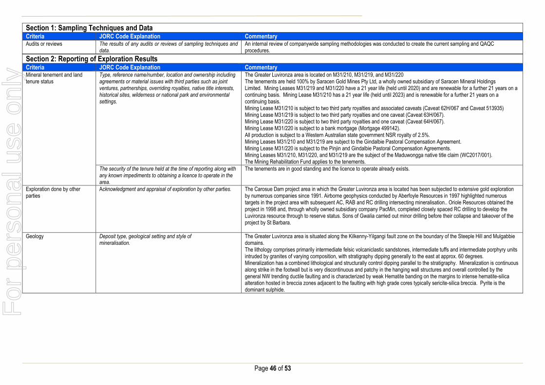
Page 46 of 53
Section 1: Sampling Techniques and Data Criteria JORC Code Explanation Commentary Audits or reviews The results of any audits or reviews of sampling techniques and
data. An internal review of companywide sampling methodologies was conducted to create the current sampling and QAQC procedures.
Section 2: Reporting of Exploration Results Criteria JORC Code Explanation Commentary Mineral tenement and land tenure status
Type, reference name/number, location and ownership including agreements or material issues with third parties such as joint ventures, partnerships, overriding royalties, native title interests, historical sites, wilderness or national park and environmental settings.
The Greater Luvironza area is located on M31/210, M31/219, and M31/220 The tenements are held 100% by Saracen Gold Mines Pty Ltd, a wholly owned subsidiary of Saracen Mineral Holdings Limited. Mining Leases M31/219 and M31/220 have a 21 year life (held until 2020) and are renewable for a further 21 years on a continuing basis. Mining Lease M31/210 has a 21 year life (held until 2023) and is renewable for a further 21 years on a continuing basis. Mining Lease M31/210 is subject to two third party royalties and associated caveats (Caveat 62H/067 and Caveat 513935) Mining Lease M31/219 is subject to two third party royalties and one caveat (Caveat 63H/067). Mining Lease M31/220 is subject to two third party royalties and one caveat (Caveat 64H/067). Mining Lease M31/220 is subject to a bank mortgage (Mortgage 499142). All production is subject to a Western Australian state government NSR royalty of 2.5%. Mining Leases M31/210 and M31/219 are subject to the Gindalbie Pastoral Compensation Agreement. Mining Lease M31/220 is subject to the Pinjin and Gindalbie Pastoral Compensation Agreements. Mining Leases M31/210, M31/220, and M31/219 are the subject of the Maduwongga native title claim (WC2017/001). The Mining Rehabilitation Fund applies to the tenements.
The security of the tenure held at the time of reporting along with any known impediments to obtaining a licence to operate in the area.
The tenements are in good standing and the licence to operate already exists.
Exploration done by other parties
Acknowledgment and appraisal of exploration by other parties. The Carosue Dam project area in which the Greater Luvironza area is located has been subjected to extensive gold exploration by numerous companies since 1991. Airborne geophysics conducted by Aberfoyle Resources in 1997 highlighted numerous targets in the project area with subsequent AC, RAB and RC drilling intersecting mineralisation.. Oriole Resources obtained the project in 1998 and, through wholly owned subsidiary company PacMin, completed closely spaced RC drilling to develop the Luvironza resource through to reserve status. Sons of Gwalia carried out minor drilling before their collapse and takeover of the project by St Barbara.
Geology Deposit type, geological setting and style of mineralisation.
The Greater Luvironza area is situated along the Kilkenny-Yilgangi fault zone on the boundary of the Steeple Hill and Mulgabbie domains. The lithology comprises primarily intermediate felsic volcaniclastic sandstones, intermediate tuffs and intermediate porphyry units intruded by granites of varying composition, with stratigraphy dipping generally to the east at approx. 60 degrees. Mineralization has a combined lithological and structurally control dipping parallel to the stratigraphy. Mineralization is continuous along strike in the footwall but is very discontinuous and patchy in the hanging wall structures and overall controlled by the general NW trending ductile faulting and is characterized by weak Hematite banding on the margins to intense hematite-silica alteration hosted in breccia zones adjacent to the faulting with high grade cores typically sericite-silica breccia. Pyrite is the dominant sulphide.
For
per
sona
l use
onl
y

Page 47 of 53
Section 2: Reporting of Exploration Results Criteria JORC Code Explanation Commentary Drillhole information A summary of all information material to the
understanding of the exploration results including a tabulation of the following information for all Material drill holes:
easting and northing of the drill hole collar
elevation or RL (Reduced Level – elevation
above sea level in metres) of the drill hole collar
dip and azimuth of the hole
down hole length and interception depth
hole length.
If the exclusion of this information is justified on the basis that the information is not Material and this exclusion does not detract from the understanding of the report, the Competent Person should clearly explain why this is the case.
A total of 868 holes have been used in the mineral resource and are deemed to be material. It is not practical to summarise all of the holes here in this release. Future drill hole data will be periodically released or when a results materially change the economic value of the project. Exclusion of the drilling information will not detract from the reader’s view of the report.
Data aggregation methods In reporting Exploration Results, weighting averaging techniques, maximum and/or minimum grade truncations (e.g. cutting of high grades) and cut-off grades are usually Material and should be stated.
All significant intercepts have been length weighted with a minimum Au grade of 1ppm. No high grade cut off has been applied.
Where aggregate intercepts incorporate short lengths of high grade results and longer lengths of low grade results, the procedure used for such aggregation should be stated and some typical examples of such aggregations should be shown in detail.
Intercepts are aggregated with minimum width of 1m and maximum width of 3m for internal dilution. Where stand out higher grade zone exist with in the broader mineralised zone, the higher grade interval is reported also.
The assumptions used for any reporting of metal equivalent values should be clearly stated.
There are no metal equivalents reported in this release.
Relationship between mineralisation widths and intercept lengths
These relationships are particularly important in the reporting of Exploration Results. If the geometry of the mineralisation with respect to the drill hole angle is known, its nature should be reported. If it is not known and only the down hole lengths are reported, there should be a clear statement to this effect (e.g. ‘down hole length, true width not known’).
Previous announcements included sufficient detail to clearly illustrate the geometry of the mineralisation and the recent drilling. All results are reported as downhole lengths.
Diagrams Appropriate maps and sections (with scales) and tabulations of intercepts should be included for any significant discovery being reported These should include, but not be limited to a plan view of drill hole collar locations and appropriate sectional views.
No Diagrams are referenced in this release.
Balanced Reporting Where comprehensive reporting of all Exploration Results are not practicable, representative reporting of both low and high grades and/or widths should be practiced to avoid misleading reporting of Exploration Results.
All results from previous campaigns have been reported, irrespective of success or not.
Other substantive exploration data
Other exploration data, if meaningful and material, should be reported including (but not limited to): geological observations; geophysical survey results; geochemical survey results; bulk samples – size and method of treatment; metallurgical test results; bulk density, groundwater, geotechnical and rock characteristics; potential deleterious or contaminating substances.
No substantive data acquisition has been completed in recent times. For
per
sona
l use
onl
y

Page 48 of 53
Section 2: Reporting of Exploration Results Criteria JORC Code Explanation Commentary Further work The nature and scale of planned further work (e.g. tests for
lateral extensions or depth extensions or large-scale step-out drilling). Diagrams clearly highlighting the areas of possible extensions, including the main geological interpretations and future drilling areas, provided this information is not commercially sensitive
Extensional exploration for the Greater Luvironza area at this time is under review. Recent results are likely to be followed up with urgency.
Deep South – Mt Celia JORC Table 1
Section 1: Sampling Techniques and Data Criteria JORC Code Explanation Commentary Sampling Techniques Nature and quality of sampling (e.g. cut channels, random chips,
or specific specialised industry standard measurement tools appropriate to the minerals under investigation, such as down hole gamma sondes, or handheld XRF instruments, etc.). These examples should not be taken as limiting the broad meaning of sampling.
Sampling methods undertaken by Saracen at Deep South have included reverse circulation drillholes (RC), aircore drilling (AC), surface and underground diamond drillholes (DD), underground face chip sampling and RC grade control drilling within the pit. Historic sampling methods conducted since 1983 have included rotary air blast (RAB), reverse circulation and diamond drillholes.
Include reference to measures taken to ensure sample representivity and the appropriate calibration of any measurement tools or systems used
Sampling for diamond, face chip and RC drilling is carried out as specified within Saracen sampling and QAQC procedures as per industry standard. RC and UG face chips and diamond core provide high quality representative samples for analysis. RC, RAB and DD core drilling was completed by previous holders to industry standard at that time (1983- 2004).
Aspects of the determination of mineralisation that are Material to the Public Report. In cases where ‘industry standard’ work has been done this would be relatively simple (e.g. ‘reverse circulation drilling was used to obtain 1 m samples from which 3 kg was pulverised to produce a 30 g charge for fire assay’). In other cases more explanation may be required, such as where there is coarse gold that has inherent sampling problems. Unusual commodities or mineralisation types (e.g. submarine nodules) may warrant disclosure of detailed information
RC chips are cone or riffle split and sampled into 1m intervals with total sample weights under 3kg Diamond core is NQ sized, sampled to 1m intervals or geological boundaries where necessary and cut into half core to give sample weights under 3 kg. UG faces are chip sampled to geological intervals (0.2 to 1m). Samples are selected to weigh less than 3 kg to ensure total sample inclusion at the pulverisation stage. Saracen core and chip samples are crushed, dried and pulverised to a nominal 90% passing 75µm to produce a 40g or 50 g sub sample for analysis by FA/AAS. Some grade control RC chips were analysed in the Saracen on site laboratory using a PAL (pulverise and leach) method. Historical RAB, RC and diamond sampling was carried out to industry standard at that time. Analysis methods include fire assay, aqua regia, atomic absorption spectroscopy and unspecified methods.
Drilling Techniques Drill type (e.g. core, reverse circulation, open-hole hammer, rotary air blast, auger, Bangka, sonic, etc.) and details (e.g. core diameter, triple or standard tube, depth of diamond tails, face-sampling bit or other type, whether core is oriented and if so, by what method, etc.).
The deposit was initially sampled by 114 RAB holes, 211 RC holes (assumed standard 5 ¼ ‘’bit size) and 29 surface HQ and unknown diameter diamond core holes. Saracen has completed 15 surface RC precollars with NQ diamond tail drill holes (precollars averaging 185m, diamond tails averaging 140m) , 3 geotechnical surface diamond NQ drillholes, 57 RC holes from surface and 107 grade control RC holes within the pit. Underground sampling activities have included 646 NQ diamond drillholes and 1596 faces. Exploration of the broader Deep South area has included 312AC holes. Diamond tails were oriented using an Ezi-mark tool. A limited amount of historic surface diamond drill core appears to have been oriented by unknown methods.
Drill Sample Recovery Method of recording and assessing core and chip sample recoveries and results assessed
RC sampling recoveries are recorded in the database as a percentage based on a visual weight estimate; limited historic recoveries have been recorded. Diamond core recovery percentages calculated from measured core versus drilled intervals are logged and recorded in the database. Recoveries average >98%. Limited historic diamond recoveries have been recorded.
For
per
sona
l use
onl
y

Page 49 of 53
Section 1: Sampling Techniques and Data Criteria JORC Code Explanation Commentary
Measures taken to maximise sample recovery and ensure representative nature of the samples
During AC and RC drilling daily rig inspections are carried out to check splitter condition, general site and address general issues. Diamond core is reconstructed into continuous runs on an angle iron cradle for orientation marking. Depths are checked against depth given on the core blocks. UG faces are sampled left to right across the face allowing a representative sample to be taken due to the vertical nature of the orebody. During GC campaigns the sample bags weight versus bulk reject weight are compared to ensure adequate and even sample recovery. Historical RAB, RC and diamond drilling to industry standard at that time.
Whether a relationship exists between sample recovery and grade and whether sample bias may have occurred due to preferential loss/gain of fine/coarse material.
There is no known relationship between sample recovery and grade for RC or AC drilling. Diamond drilling has high recoveries meaning loss of material is minimal. Any historical relationship is not known.
Logging Whether core and chip samples have been geologically and geotechnically logged to a level of detail to support appropriate Mineral Resource estimation, mining studies and metallurgical studies. Whether logging is qualitative or quantitative in nature. Core (or costean, channel, etc) photography.
Logging of RC and AC chips and diamond drill core records lithology, mineralogy, texture, mineralisation, weathering, alteration and veining. Geotechnical and structural logging is carried out on all diamond holes to record recovery, RQD, defect number, type, fill material, shape and roughness and alpha and beta angles. Chips from all RC holes (exploration and GC) are stored in chip trays for future reference while remaining core is stored in core trays and archived on site. All faces are photographed and mapped. Core is photographed in both dry and wet state. Qualitative and quantitative logging of historic data varies in its completeness.
The total length and percentage of the relevant intersections logged
All AC, RC and diamond drillholes and grade control holes are logged in full. Historical logging is complete.
Sub-sampling techniques and sample preparation
If core, whether cut or sawn and whether quarter, half or all core taken.
All drill core is cut in half onsite using an automatic core saw. Some grade control diamond holes have been full core sampled. Samples are always collected from the same side. Some historic drillcore was half core sampled, or sampled via unknown methods.
If non-core, whether riffled, tube sampled, rotary split, etc and whether sampled wet or dry.
All exploration and grade control RC samples are cone or riffle split. AC drillholes are spear sampled. Occasional wet samples are encountered; increased air capacity is routinely used to aid in keeping the sample dry when water is encountered. UG faces are chip sampled using a hammer. Historic RAB and RC drilling was sampled using riffle and unknown methods.
For all sample types, the nature, quality and appropriateness of the sample preparation technique.
The sample preparation of diamond core, UG face chips and RC chips adhere to industry best practice. It is conducted by a commercial laboratory or onsite laboratory and involves oven drying, coarse crushing then total grinding to a size of 90% passing 75 microns. Best practice is assumed at the time of historic sampling.
Quality control procedures adopted for all sub-sampling stages to maximise representivity of samples.
All subsampling activities are carried out by commercial laboratory or onsite laboratory and are considered to be satisfactory. Sampling by previous holders assumed to be industry standard at the time.
Measures taken to ensure that the sampling is representative of the in situ material collected, including for instance results for field duplicate/second half sampling.
RC field duplicate samples are carried out at a rate of 1:20 and are sampled directly from the on-board splitter on the rig. These are submitted for the same assay process as the original samples and the laboratory are unaware of such submissions. Sampling by previous holders assumed to be industry standard at the time.
Whether sample sizes are appropriate to the grain size of the material being sampled.
Sample sizes of 3kg are considered to be appropriate given the grain size (90% passing 75 microns) of the material sampled.
Quality of assay data and laboratory tests
The nature, quality and appropriateness of the assaying and laboratory procedures used and whether the technique is considered partial or total.
RC and UG chip samples and diamond core are analysed by external laboratories using a 50g fire assay with AAS finish. AC samples are analysed using a 25g aqua regia digest. These methods are considered suitable for determining gold concentrations in rock and are total digest methods. GC samples were analysed in the Saracen onsite laboratory using a pulverise and leach method. This method is a partial digest. Historic sampling includes fire assay, aqua regia, atomic absorption spectroscopy and unspecified methods.
For
per
sona
l use
onl
y

Page 50 of 53
Section 1: Sampling Techniques and Data Criteria JORC Code Explanation Commentary
For geophysical tools, spectrometers, handheld XRF instruments, etc, the parameters used in determining the analysis including instrument make and model, reading times, calibrations factors applied and their derivation, etc.
No geophysical tools have been utilised for reporting gold mineralisation.
Nature of quality control procedures adopted (e.g. standards, blanks, duplicates, external laboratory checks) and whether acceptable levels of accuracy (i.e. lack of bias) and precision have been established.
Certified reference material (standards and blanks) with a wide range of values are inserted into every drillhole at a rate of 1:25 for exploration AC, RC and DD, and 1:40 for GC drilling. These are not identifiable to the laboratory. QAQC data returned are checked against pass/fail limits with the SQL database and are passed or failed on import. A report is generated and reviewed by the geologist as necessary upon failure to determine further action. QAQC data is reported monthly. Sample preparation checks for fineness are carried out to ensure a grindsize of 90% passing 75 microns. The laboratory performs a number of internal processes including standards, blanks, repeats and checks. QAQC data analysis demonstrates sufficient accuracy and precision. Industry best practice is assumed for previous holders.
Verification of sampling and assaying
The verification of significant intersections by either independent or alternative company personnel.
Significant intercepts are verified by the Geology Manager and corporate personnel.
The use of twinned holes. No specific twinned holes have been drilled at Deep South but grade control drilling has confirmed the width and grade of previous exploration drilling.
Documentation of primary data, data entry procedures, data verification, data storage (physical and electronic) protocols
Primary data is collated in a set of excel templates utilising lookup codes. This data is forwarded to the Database Administrator for entry into a secure acQuire database with inbuilt validation functions. Data from previous owners was taken from a database compilation and validated as much as practicable before entry into the Saracen acQuire database.
Discuss any adjustment to assay data. No adjustments have been made to assay data. First gold assay is utilised for resource estimation.
Location of data points Accuracy and quality of surveys used to locate drillholes (collar and down-hole surveys), trenches, mine workings and other locations used in Mineral Resource estimation.
Exploration drillholes are located using a Leica 1200 GPS with an accuracy of +/- 10mm. Drillhole collars within the pit and immediate surrounds are picked up by company surveyors using a Trimble R8 GNSS (GPS) with an expected accuracy of +/-8mm. All underground drillhole collars are picked up by company surveyors using a Leica TS15i (total station) with an expected accuracy of +/-2mm. Underground faces are located using a Leica D5 disto with and accuracy of +/- 1mm from a known survey point. Downhole surveys are carried out using the DeviFlex RAPID continuous inrod survey instrument taking readings every 5 seconds, In and Out runs and reported in 3m intervals, survey accuracy +-3:1000. A number of drillholes have also been gyroscopically surveyed. Previous holders’ survey accuracy and quality is unknown
Specification of the grid system used. A local grid system (Safari Bore) is used at Deep South. The two point conversion to MGA_GDA94 zone 51 is: SBEast SBNorth RL MGAEast MGANorth RL Point 1 51000 34000 0 451137.753 6734157.921 0 Point 2 51000 30000 0 451137.896 6730157.896 0 Historic data is converted to the Safari Bore local grid upon export from the database.
Quality and adequacy of topographic control. Topographic control originally used site based survey pickups in addition to Kevron aerial photogrammetric surveys with +/- 5m resolution. Pre mining, new and more detailed topography has since been captured and will be used in future updates and for subsequent planning purposes.
Data spacing and distribution Data spacing for reporting of Exploration Results. The nominal spacing for drilling is 20m x 40m and 40m x 40m
Whether the data spacing and distribution is sufficient to establish the degree of geological and grade continuity appropriate for the Mineral Resource and Ore Reserve estimation procedure(s) and classifications applied.
Data spacing and distribution are sufficient to establish the degree of geological and grade continuity appropriate for JORC classifications applied.
For
per
sona
l use
onl
y

Page 51 of 53
Section 1: Sampling Techniques and Data Criteria JORC Code Explanation Commentary Orientation of data in relation to geological structure
Whether sample compositing has been applied.
AC drilling is sampled in 4m composites, no other sample compositing has been utilised Some historic RAB and RC sampling was composited into 3-4m samples with areas of interest re-sampled to 1m intervals. It is unknown at what threshold this occurred.
Whether the orientation of sampling achieves unbiased sampling of possible structures and the extent to which this is known, considering the deposit type.
The majority of drillholes are positioned to achieve optimum intersection angles to the ore zone as are practicable.
If the relationship between the drilling orientation and the orientation of key mineralised structures is considered to have introduced a sampling bias, this should be assessed and reported if material.
No significant sampling bias has been recognised due to orientation of drilling in regards to mineralised structures.
Sample security The measures taken to ensure sample security. Samples are prepared on site under supervision of Saracen geological staff. Samples are selected, bagged into tied numbered calico bags then grouped into secured cages and collected by the laboratory personnel. Sample submissions are documented via laboratory tracking systems and assays are returned via email
Audits or reviews The results of any audits or reviews of sampling techniques and data.
An internal review of companywide sampling methodologies was conducted to create the current sampling and QAQC procedures. No external audits or reviews have been conducted.
Section 2: Reporting of Exploration Results Criteria JORC Code Explanation Commentary Mineral tenement and land tenure status
Type, reference name/number, location and ownership including agreements or material issues with third parties such as joint ventures, partnerships, overriding royalties, native title interests, historical sites, wilderness or national park and environmental settings.
The Deep South pit is located on M39/740. The tenement is held 100% by Saracen Gold Mines Pty Ltd, a wholly owned subsidiary of Saracen Mineral Holdings Limited. Mining Lease M39/740 has a 21 year life (held until 2024) and is renewable for a further 21 years on a continuing basis. Mining Lease M39/740 is subject to one royalty agreement, one caveat (151H/067) and a bank mortgage (499142). All production is subject to a Western Australian state government NSR royalty of 2.5%. Mining Lease M39/740 is subject to the Edjudina Pastoral Compensation Agreement. There are no registered Aboriginal Heritage sites within Mining Lease M39/740. The Mining Rehabilitation Fund applies to Mining Lease 39/740.
The security of the tenure held at the time of reporting along with any known impediments to obtaining a licence to operate in the area.
The tenement is in good standing and the licence to operate already exists
Exploration done by other parties
Acknowledgment and appraisal of exploration by other parties. Exploration in the vicinity of Deep South commenced in the 1980’s with drilling around the historic Deep Well workings 500m north of Deep South, as well as regional RC drilling carried out by Western Mining Corporation. Initial auger sampling carried out over Deep South by Pancontinental Mining in 1994 failed to detect mineralisation due to the transported material overlying the deposit. Wide spaced east angled RAB drilling carried out by Goldfields in 1999 intersected mineralisation, but results were not repeated in further drilling and the project area was sold to Sons of Gwalia. Sons of Gwalia completed extensive RC and diamond drilling to define the Deep South resource, with mining operations undertaken in 2004 before their collapse and takeover by St Barbara.
Geology Deposit type, geological setting and style of mineralisation.
Deep South lies on the eastern margin of the Norseman – Wiluna greenstone belt. This belt is differentiated into numerous structural-stratigraphic domains separated by major regional structures, with Deep South located within the narrow NNW trending Linden Domain. The lithology comprises metasedimentary and felsic volcaniclastic rocks with an ultramafic and high magnesium basalt layer.
For
per
sona
l use
onl
y

Page 52 of 53
Section 2: Reporting of Exploration Results Criteria JORC Code Explanation Commentary
Mineralisation occurs in two loads concordant to geology, the Butler and Scarlett lodes, and is confined between layered metasedimentary and felsic volcaniclastic units on both the hangingwall and footwall. The two lodes are separated by a high magnesium basalt and an ultramafic unit. The Butler lode is located in the hangingwall and is strongly silica and pyrrhotite-pyrite altered, and well laminated (appearing like a BIF within the oxidise portion). The contrasting physical properties of this unit to the surrounding unit have created fluid pathways and traps, as well as the high iron content of the unit providing a chemical trap, for gold deposition The Scarlett lode is strongly weathered in the upper oxide portion to a gossanous material comprising hematite, goethite and quartz fragments. Weathering at Deep South has been preferential along Scarlett lode due to its high carbonate content. Where fresh, the lode is a fine grained banded carbonate unit with variable pyrrhotite, pyrite and magnetite. It is weakly foliated in line with the regional foliation.
Drillhole information A summary of all information material to the understanding of the exploration results including a tabulation of the following information for all Material drill holes:
easting and northing of the drill hole collar
elevation or RL (Reduced Level – elevation
above sea level in metres) of the drill hole collar
dip and azimuth of the hole
down hole length and interception depth
hole length.
If the exclusion of this information is justified on the basis that the information is not Material and this exclusion does not detract from the understanding of the report, the Competent Person should clearly explain why this is the case.
All material data is periodically released on the ASX: 15/02/2018, 27/11/2017, 26/09/2017, 01/05/2017, 21/02/2017, 17/12/2016, 07/09/2016, 11/05/2016, 23/02/2016, 23/07/2013, 10/10/2012, 31/07/2012, 03/06/2011, 29/07/2010 Future drill hole data will be periodically released or when a results materially change the economic value of the project. Exclusion of the drilling information will not detract from the reader’s view of the report.
Data aggregation methods In reporting Exploration Results, weighting averaging techniques, maximum and/or minimum grade truncations (e.g. cutting of high grades) and cut-off grades are usually Material and should be stated.
All significant intercepts have been length weighted with a minimum Au grade of 1ppm, or 20ppb for AC drilling No high grade cut off has been applied.
Where aggregate intercepts incorporate short lengths of high grade results and longer lengths of low grade results, the procedure used for such aggregation should be stated and some typical examples of such aggregations should be shown in detail.
Intercepts are aggregated with minimum width of 1m and maximum width of 3m for internal dilution. Where stand out higher grade zone exist with in the broader mineralised zone, the higher grade interval is reported also.
The assumptions used for any reporting of metal equivalent values should be clearly stated.
There are no metal equivalents reported in this release.
Relationship between mineralisation widths and intercept lengths
These relationships are particularly important in the reporting of Exploration Results. If the geometry of the mineralisation with respect to the drill hole angle is known, its nature should be reported. If it is not known and only the down hole lengths are reported, there should be a clear statement to this effect (eg ‘down hole length, true width not known’).
Previous announcement included sufficient detail to clearly illustrate the geometry of the mineralisation and the recent drilling. All results are reported as downhole lengths. This remains consistent with other announcements.
Diagrams Appropriate maps and sections (with scales) and tabulations of intercepts should be included for any significant discovery being reported These should include, but not be limited to a plan view of drill hole collar locations and appropriate sectional views.
All significant exploration results released by Saracen are accompanied by the appropriate diagrams and maps at the time of the release.
For
per
sona
l use
onl
y
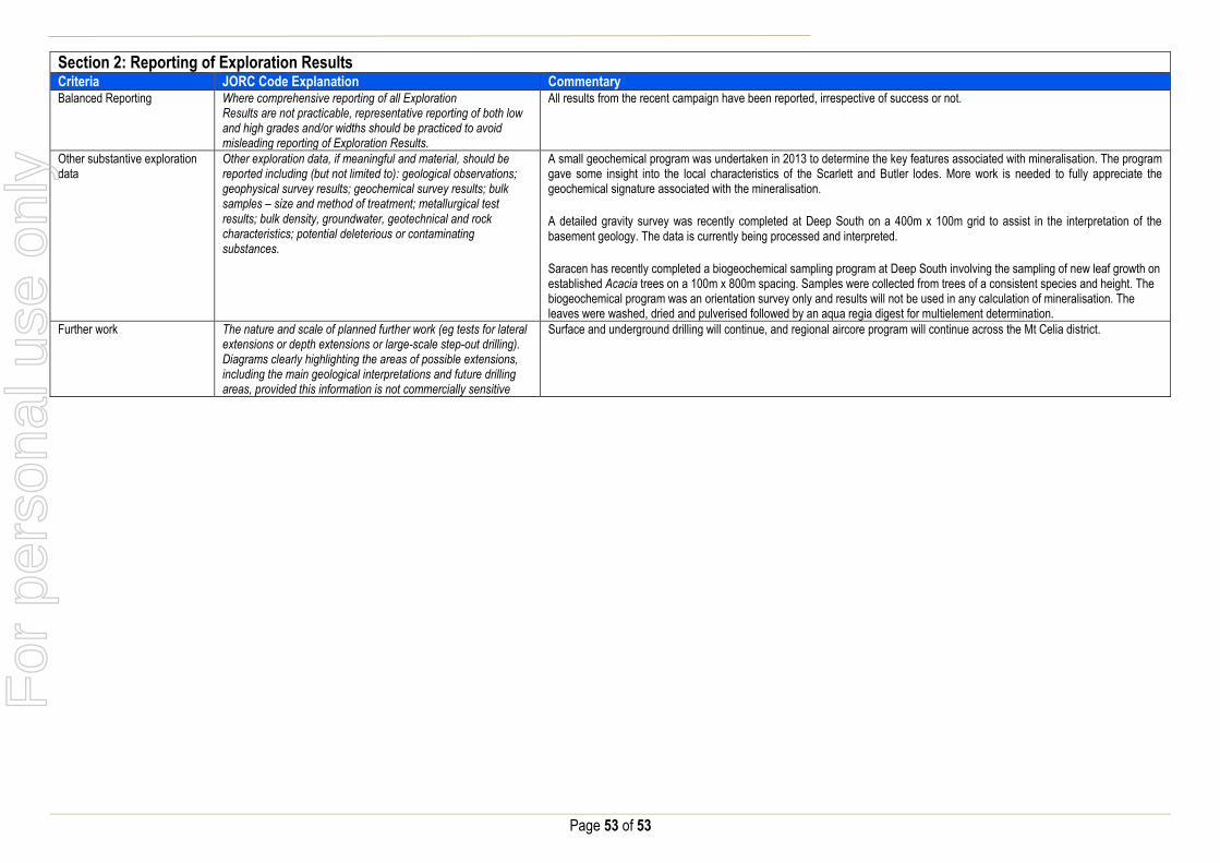
Page 53 of 53
Section 2: Reporting of Exploration Results Criteria JORC Code Explanation Commentary Balanced Reporting Where comprehensive reporting of all Exploration
Results are not practicable, representative reporting of both low and high grades and/or widths should be practiced to avoid misleading reporting of Exploration Results.
All results from the recent campaign have been reported, irrespective of success or not.
Other substantive exploration data
Other exploration data, if meaningful and material, should be reported including (but not limited to): geological observations; geophysical survey results; geochemical survey results; bulk samples – size and method of treatment; metallurgical test results; bulk density, groundwater, geotechnical and rock characteristics; potential deleterious or contaminating substances.
A small geochemical program was undertaken in 2013 to determine the key features associated with mineralisation. The program gave some insight into the local characteristics of the Scarlett and Butler lodes. More work is needed to fully appreciate the geochemical signature associated with the mineralisation.
A detailed gravity survey was recently completed at Deep South on a 400m x 100m grid to assist in the interpretation of the basement geology. The data is currently being processed and interpreted.
Saracen has recently completed a biogeochemical sampling program at Deep South involving the sampling of new leaf growth on established Acacia trees on a 100m x 800m spacing. Samples were collected from trees of a consistent species and height. The biogeochemical program was an orientation survey only and results will not be used in any calculation of mineralisation. The leaves were washed, dried and pulverised followed by an aqua regia digest for multielement determination.
Further work The nature and scale of planned further work (eg tests for lateral extensions or depth extensions or large-scale step-out drilling). Diagrams clearly highlighting the areas of possible extensions, including the main geological interpretations and future drilling areas, provided this information is not commercially sensitive
Surface and underground drilling will continue, and regional aircore program will continue across the Mt Celia district.
For
per
sona
l use
onl
y


![Chemical changes and structure - Lossiemouth …253303]Numeracy... · Web viewe) 8.0g of copper (II) oxide f) 2.2g of carbon dioxide 3. a) The mass of a mole of hydrocarbon was found](https://static.fdocuments.net/doc/165x107/5e8bbb077fa1f307ca25d7be/chemical-changes-and-structure-lossiemouth-253303numeracy-web-view-e-80g.jpg)

