SAOCOM-CS Mission and ESA Airborne Campaign Data
20
SAOCOM-CS Mission and ESA Airborne Campaign Data Malcolm Davidson Head of the EOP Campaign Section [email protected]
Transcript of SAOCOM-CS Mission and ESA Airborne Campaign Data

SAOCOM-CS Mission and ESA Airborne Campaign Data
Malcolm Davidson Head of the EOP Campaign Section

Objectives of presentation
• Introduce a new type of ESA SAR mission with Polarimetrice, Interferometric and Bistatic measurement capabilities
• Present ESA airborne SAR campaigns which provide a useful source of data for SAR training and new science development
Overview
• SAOCOM Companion Satellite Mission (a new type of SAR mission) – Background – Mission Capabilities – Mission Science
• ESA airborne campaigns – Background and objectives of campaigns – Example SAR campaigns – Access to Data

The SAOCOM Mission • The Argentinian Space Agency CONAE - with contributions from ASI
- is developing an L-band SAR mission
• 2 satellites SAOCOM-1A/1B flying in constellation with COSMO-SkyMed (forming toegther the SIASGE L+X-band SAR system) 619.6 km altitude, incidence angle range 17.50 – 500
L-band SAR at 1275 MHz, bandwidth up to 50 MHz peak RF transmit power 3.1 kW antenna dimensions 10 m x 3.5 m fully polarimetric, interferometric capabilities multiple modes (Strip, TOPS)
• In 2013, CONAE offered ESA to launch a small satellite together with SAOCOM 1B
• ESA, together with European experts and CONAE have assessed the feasibility to fly a passive add-on satellite in formation with SAOCOM to enhance the science return (condition for cooperation from CONAE)

• “Companion Satellite” (“SAOCOM-CS”) receive-only, dual-pol L-band SAR satellite (close) formation with SAOCOM SAOCOM as illuminator
• Complement science return of SAOCOM New radar science: tomography, bistatic measurements mapping of biomass and structure of boreal forests by SAR tomography (mission driver) several imaging geometries (baselines and angles) for experimental
applications Detailed studies by POLIMI, DLR and CSL to confirm mission science
program
• Launcher & schedule constraints Falcon-9, available volume: cylinder, 1.5 m diameter x 1.4 m height max. total launch mass: ca. 400 kg tight schedule imposes maximum reuse of existing equipment / high TRL
SAOCOM-CS Description CS SAOCOM

Science snd Observation Geometry
SAOCOM CS (ESA) SAOCOM (CONAE)
Illuminated scene
• Four configurations w.r.t baselines and viewing geometry • Three science mission phases: tomographic, bistatic, specular
“Birds-eye view”
Tomographic phase AT baseline < 6 km XT baseline varies ~1–6 km Science mission driver Duration ~2.5 years
Specular phase Experimental Short duration
Bistatic 1, Bistatic 2 AT baseline < 250 km Small XT baseline (phase
1) Large XT baseline (phase
2) Duration ~2 years

Science objectives • Tomographic Configuration
– Boreal forest structure (mission science driver)
– Tropical forest structure (experiment) – Ice subsurface feature mapping (experiment)
• Bistatic interferometry and radar signatures – Dense persistent scatterers (PS) for urban
environments (demonstration) – Bistatic interferometry for surface motion and land
cover properties (demonstration) – Soil moisture (experiment) – Desert subsurface mapping (experiment)
• Specular configuration
– Soil moisture (experiment)

SAOCOM + SAOCOM-CS - 3 independent types of information depending on geometry & baselines
PolSAR (SAR Polarimetry)
x
y
z
o
PolInSAR (Polarimetric SAR Interferometry)
x
y
z
o
Height
Tomo SAR (SAR Tomography)
x
y
z
o
SAOCOM only SAOCOM+CS (1 pass) SAOCOM+CS (>1 passes)
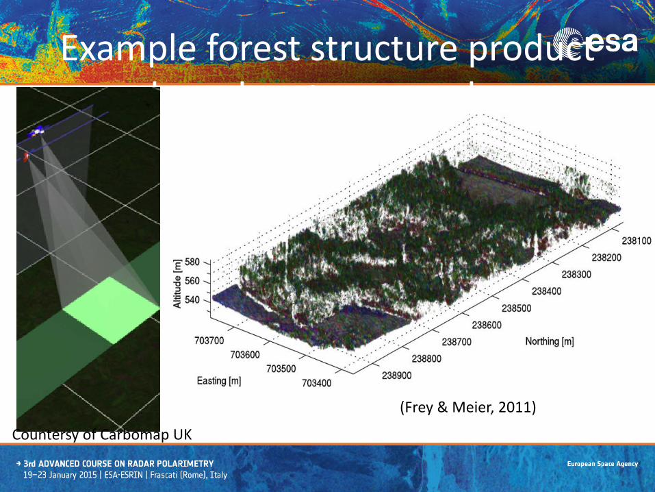
Example forest structure product based on tomography
(Frey & Meier, 2011)
Countersy of Carbomap UK

Example ice subsurface product
Taba
ldin
i (PO
LIM
I) N
agle
r (EN
VEO
)
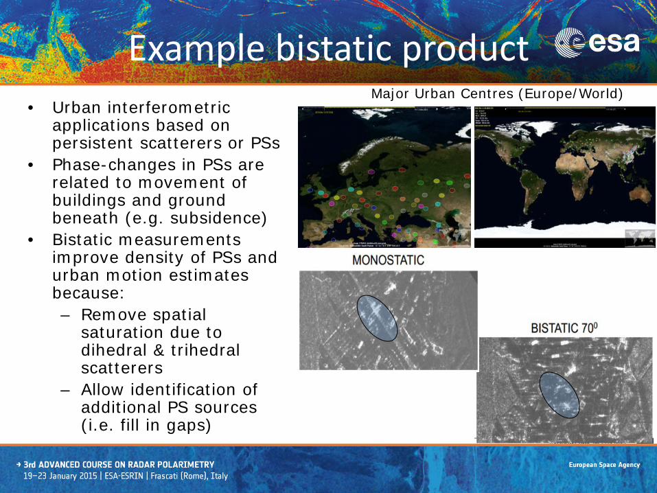
• Urban interferometric applications based on persistent scatterers or PSs
• Phase-changes in PSs are related to movement of buildings and ground beneath (e.g. subsidence)
• Bistatic measurements improve density of PSs and urban motion estimates because: – Remove spatial
saturation due to dihedral & trihedral scatterers
– Allow identification of additional PS sources (i.e. fill in gaps)
Major Urban Centres (Europe/World)
Example bistatic product
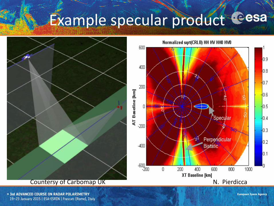
Example specular product
N. Pierdicca Countersy of Carbomap UK

• SAOCOM-CS mission characteristics 5m resolution/6 minutes of operation per orbit 3 x 1m antenna Formation flying with 3 main geometries
(tomographic, bistatic and specular) 400kg wet mass Launch as co-passenger on Falcon-9
• Ground Segment • Mission Control Centre (core of flight operations
segment) • Two X-band ground stations for science data
downlink • A (distributed) PDGS for science data processing
• Short development schedule (ready for launch by 2nd half 2018)
Mission Implementation

ESA Campaigns

Programmatic Background
• Programme started in 1981 – 100+ campaigns as of 2015 – 5-6 campaigns/year
• Strategic objectives: 1) Support to EO programs 2) Improved access to airborne
instrumentation and data in Europe
3) Partnerships with national and international organisation ESA Campaigns Programme addresses all phases of ESA missions
• Campaign activities address three main areas: technology, mission development and calibration/validation
Presenter
Presentation Notes
ESA campaigns strongly linked to EO missions (various phases of development) Dynamic program Partnerships to be as effective as possible

ESA airborne SAR campaigns - overview
1. ESA airborne campaign activities addressing forest biomass generally executed in framework of future mission concepts
a. TerraSAR-L (up to 2004) b. EE7 BIOMASS (2005 to present)
2. In addition we address PolInSAR workshop recommendations where possible
3. Main campaign datasets to date a. Indonesian Radar Experiment (Indrex-2) over
tropical forests in Borneo in 2004 with DLR b. BioSAR-1,-2 and -3 over boreal forests in Sweden
(DLR, ONERA) c. TropiSAR 2009 over tropical forest in French
Guyana (ONERA) d. TropiScat scatterometer measurements in French
Guyana (CESBIO, ONERA, POLIMI) 4. Campaign datasets generally include well-
documented airborne and ancillary data (e.g. lidar, ground biomass estimates, tree height data)
ESA UNCLASSIFIED – For Official Use

ESA UNCLASSIFIED – For Official Use
Example campaign: TropiSAR 2009 (1)
• Aims – Support BIOMASS Phase-A – Collect reference radar at P-
and L-band over tropical forests
– Quantify temporal decorrelation to support mission orbit selection
– Provide basis for forest biomass retrieval algorithm
– Assess product validation methodology
• Experiment details – Collaboration with CNES and
French national programmes (GUYAFOR) in French Guyana
– Airborne acquisitions using SETHI and Falcon-20 (ONERA)
– Coincident ground and laser altimeter measurements

ESA UNCLASSIFIED – For Official Use
Example campaign: TropiSAR 2009 (2)
3. Outcome – Development of airborne SAR
processing chain (capacity building)
– 60 acquisitions processed and delivered in Q1/11
– Data analysis indicates: • moderate temporal
decorrelation at P-band over tropical forests
• Feasibility of forest height retrieval in tropics
• Importance of terrain correction
• Consolidated dataset input to BIOMASS scientific support/End-to-end studies
P-band radar height map Height validation vs lidar
Radar database
Lidar height (m)
Rada
r he
ight
(m
)

ESA UNCLASSIFIED – For Official Use
Access to ESA Campaign Data
• ESA campaign data available to interested PIs
– Formatted and documented datasets
– Data Inventory – Final report with full
description of campaign activity and analyses
• Final report accessible directly through web
• Access to datasets provided through Category 1 mechanism (short proposal incl. identification of desired datasets)
• Currently 56 campaign datasets available
http://eopi.esa.int

Conclusions
• SAOCOM-CS a small satellite SAR mission with highly innovative measurements from space (example of R & D satellite)
• ESA has organised a number of airborne SAR campaigns in past 15 years in support of spaceborne missions (BIOMASS, SAOCOM-CS, TerraSAR-L, Sentinel-1)
• A number of airborne SAR datasets available to the science community via campaign database