Santa Margarita Creek Bank Stabilization - Caltrans Margarita Creek Bank Stabilization ... the Santa...
45
Santa Margarita Creek Bank Stabilization At 0.3 Mile South of Tassajara Creek Road 05-SLO-101-PM 36.5 EA 05-1F5600 Project ID: 0514000009 Initial Study With Proposed Mitigated Negative Declaration Prepared by the State of California Department of Transportation August 2014
Transcript of Santa Margarita Creek Bank Stabilization - Caltrans Margarita Creek Bank Stabilization ... the Santa...

Santa Margarita Creek Bank Stabilization
At 0.3 Mile South of Tassajara Creek Road
05-SLO-101-PM 36.5
EA 05-1F5600 Project ID: 0514000009
Initial Study With Proposed
Mitigated Negative Declaration
Prepared by the
State of California Department of Transportation
August 2014

General Information About This Document
What’s in this document:
The California Department of Transportation (Caltrans) has prepared this Initial Study, which
examines the potential environmental impacts of alternatives being considered for the proposed
project in San Luis Obispo, California. The document describes the project, the existing
environment that could be affected by the project, potential impacts from the project, and
proposed avoidance, minimization, and/or mitigation measures.
What you should do:
Please read this Initial Study. Additional copies of this document as well as the technical studies
are available for review at the Caltrans district office at 50 Higuera Street, San Luis Obispo, CA
93401, the Santa Margarita and San Luis Obispo Public Libraries, and electronically at
http://www.dot.ca.gov/dist05/projects/.
We welcome your comments. If you would like the opportunity for a public hearing or have
comments – please submit any comments or concerns via U.S. mail to Caltrans at the
following address:
Randy LaVack, Senior Environmental Planner
Environmental Stewardship Branch
California Department of Transportation
50 Higuera Street
San Luis Obispo, CA 93401
Or submit comments via email to: [email protected].
Submit comments by the deadline: October 15th
, 2014.
What happens next:
After comments are received from the public and reviewing agencies, Caltrans may
1) give environmental approval to the proposed project, 2) do additional environmental studies,
or 3) abandon the project. If the project is given environmental approval and funding is
appropriated, Caltrans could design and build all or part of the project.
For individuals with sensory disabilities, this document is available in Braille, in large print, on audiocassette, or on
computer disk. To obtain a copy in one of these alternate formats, please call or write to Caltrans, Attn: Randy
LaVack, Environmental Stewardship Branch, 50 Higuera Street, San Luis Obispo, CA. 93401; (805) 549-3182 or
use California Relay Service 1 (800) 735-2929 (TTY), 1 (800) 735-2929 (Voice), or 711.

Santa Margarita Creek Bank Stabilization Project 1
PROJECT DESCRIPTION AND BACKGROUND:
Project Title: Santa Margarita Creek Bank Stabilization Project
Lead Agency Name and
Address:
California Department of Transportation (Caltrans)
50 Higuera Street. San Luis Obispo, CA 93401
Contact Person: Randy LaVack, (805) 549-3182
Project Location: The project site is located along the northbound
shoulder of US 101 at highway postmile 36.5, in San
Luis Obispo County. The site is on the east slope of the
Santa Lucia Range and within the greater Salinas River
Watershed. The global positioning system coordinates
for the location are: 35°21’58.60”N and -
120°38’22.56”W. Work will occur in Santa Margarita
Creek 0.3 mile south of Tassajara Creek Road.
Project Sponsor’s Name
and Address:
California Department of Transportation (Caltrans)
Randy LaVack, Senior Environmental Planner
50 Higuera Street
San Luis Obispo, CA 93401
General Plan Description: The project purpose is to prevent loss of the US 101
roadway. US 101 is the primary north-south corridor
for coastal California and an important transportation
route for commerce and the traveling public. The
project is needed to maintain a safe travelway.
Zoning: US 101 is California’s primary north-south coastal
transportation corridor. Santa Margarita Creek parallels
US 101 on the east side of the Santa Lucia Range in an
area known as Cuesta Pass. The left bank of Santa
Margarita Creek is advancing into the State right-of
way (R/W) toward the right hand, northbound travel
lane.
Description of Project: The bank of Santa Margarita Creek is eroding into the
northbound shoulder of US 101. This was apparently
started by a fallen tree that led to accumulation of
sediment and deflection of the creek channel toward the
highway. The creek has cut under wildlife fencing
installed in the area that was built to limit
vehicle/animal collisions. Continued bank cutting will
eventually threaten the right-hand northbound lane of

Santa Margarita Creek Bank Stabilization Project 2
US 101. The project will reclaim lost shoulder width
and traffic recovery area by restoring the original bank
alignment, removing accumulated material in the
original flow line, and stabilizing the bank against
future erosion. The benefits of this work are the
protection of northbound US 101 travel lanes,
maintaining safety by restoring the integrity of the
wildlife fencing through the area, and reducing
sediment load caused by on-going bank erosion in
Santa Margarita Creek.
This project will restore the original bank and creek
alignment by placing rock and live tree pole plantings
in the eroded area and removing accumulated sediment
in the channel. Staging will occur along the road
shoulder. There are no utilities in the affected area that
require alteration or relocation.
Surrounding Land Uses
and Setting:
The project location and surrounding area is located on
the eastern slope of the Santa Lucia Range and much of
the Santa Lucia Range is within the Los Padres
National Forest. The surrounding land use is rural
residential, rangelands used for grazing, and National
Forest. Within and near the project area Santa
Margarita Creek is paralleled by US 101 on the west
and railroad tracks on the east. The creek is a perennial
tributary to the Salinas River and contains
approximately eight miles of streambed before its
confluence with the Salinas River.
The primary natural habitats in and near the project
area are: Central Coast Cottonwood-Sycamore Riparian
and Riverine along Santa Margarita Creek, and Non-
native Grassland along the roadway shoulder. The US
101 area is also an important wildlife corridor linking
the Los Padres National forest to east with the coast
range to the west.
See attached pictures in Appendix A.
Other Public Agencies
Whose Approval is
Required:
The project location is within the jurisdiction of the
Army Corps of Engineers (ACOE), California Regional
Water Quality Control Board (CRWQCB), the
California Department of Fish and Wildlife (CDFW),
the U.S. Fish and Wildlife Service (USFWS), and the
National Marine Fisheries Service (NMFS).

Santa Margarita Creek Bank Stabilization Project 3
ENVIRONMENTAL FACTORS POTENTIALLY AFFECTED:
The environmental factors checked below would be potentially affected by this project. Please see the
CEQA checklist for additional information. Any boxes not checked represent issues that were
considered as part of the scoping and environmental analysis for the project, but for which no adverse
impacts were identified; therefore, no further discussion of those issues is in this document.
Aesthetics Agriculture and Forestry Air Quality
Biological Resources Cultural Resources Geology/Soils
Greenhouse Gas
Emissions Hazards and Hazardous
Materials Hydrology/Water Quality
Land Use/Planning Mineral Resources Noise
Paleontology Population/Housing Public Services
Recreation Transportation/Traffic Utilities/Service Systems
Mandatory Findings of Significance

Santa Margarita Creek Bank Stabilization Project 4
Mitigated Negative Declaration Pursuant to: Division 13, Public Resources Code
Project Description
The California Department of Transportation (Caltrans) proposes to stabilize the bank
of Santa Margarita Creek located north of the City of San Luis Obispo on U.S. 101 in
San Luis Obispo County. The purpose of the work is to prevent further erosion into
the State right-of-way and eventually the northbound lanes of US 101; the primary
north-south coastal route for California travel and commerce. The project will reclaim
lost shoulder width and traffic recovery area by restoring the original bank alignment,
removing accumulated material in the original flow line, and stabilizing the bank
against future erosion. The benefits of this work are the protection of northbound US
101 travel lanes, maintaining safety by restoring the integrity of the wildlife fencing
through the area, and reducing sediment load caused by on-going bank erosion in
Santa Margarita Creek.
Determination
This proposed Mitigated Negative Declaration is included to give notice to interested
agencies and the public that it is Caltrans’ intent to adopt a Mitigated Negative
Declaration for this project. This does not mean that Caltrans’ decision on the project
is final. This Mitigated Negative Declaration is subject to change based on comments
received by interested agencies and the public.
Caltrans has prepared an Initial Study for this project and, pending public review,
expects to determine from this study that the proposed project would not have a
significant effect on the environment for the following reasons.
The proposed project would have no effect on: Aesthetics, Greenhouse Gas
Emissions, Land Use/Planning, Paleontology, Recreation, Agriculture and Forestry,
Cultural Resources, Hazards and Hazardous Materials, Mineral Resources,
Population/Housing, Transportation/Traffic, Air Quality, Geology/Soils,
Hydrology/Water Quality, Noise, Public Services, and Utilities/Service Systems.
In addition, the proposed project would have no significantly adverse effect on
biological resources because the following mitigation measures would reduce
potential effects to insignificance:
Bio-1. Construction will occur between August and October 15 to avoid the wet
season.

Santa Margarita Creek Bank Stabilization Project
Bio-2. Staging area between creek and road. All equipment will have drip pans to
collect potential leaks.
Bio-3. All fueling in controlled environment outside of creek banks.
Bio-4. Caltrans Construction Site Best Management Practices shall be
implemented to minimize effects to steelhead and all habitats in the project area.
Bio-5. During RSP placement, soil will be incorporated within the RSP to allow
planting of locally obtained willows and cottonwoods at a 3:1 ratio.
Bio-6. Prior to the start of construction a qualified biologist shall monitor the
installation of ESA fencing and/or well marked stakes to delineate the boundaries
of construction limits.
Bio-7. A pumped diversion will be installed around the work area. The diversion
shall consist of an up and down creek cofferdam constructed of hay bales, sand
bags, visqueen, plywood, and/or other silt fee materials. Prior to constructing the
up creek cofferdam, woody debris will be hand removed from the creek channel.
Once material is removed a block-net will be installed up creek of the diversion
and another block net walked down creek to just beyond the anticipated sediment
basin location. Any fish stranded between the cofferdam and the net will be
captured and moved to an appropriate predetermined relocation site (likely the
pool at the Tassajara Creek Road Bridge). The upper cofferdam and sediment
basin will isolate the work area. A pump in a screened basket or bucket (mesh
maximum of 0.2 inch), will pump water to the sediment basin. Screening will
prevent entrainment of fish should they access the pump location. Water trapped
in the work area or dewatered from that area will be pumped into a Baker tank
for settling prior to discharge onto the vegetated creek bank or will be retained in
a settling basin made of haybales, plywood, and plastic sheeting.
Bio-8. Following the completion of the project, sediment collected in the
sediment basin or Baker tank will be removed prior to deconstructing the basin.
Bio-9. Following the completion of construction, disturbed area will be restored
using a combination of the following: jute fiber erosion control blanket, fiber
rolls, use of a seed mix containing locally occurring native species, and willow
and cottonwood cuttings on disturbed banks and in the RSP.
Bio-10. Prior to the start of construction a qualified biologist shall present a
worker awareness training to all construction personnel, and the Resident
Engineer and/or his designee.
Bio-11. A qualified biologist shall be onsite during installation and removal of the
water diversion and all initial ground disturbing activities. A qualified biologist is


Santa Margarita Creek Bank Stabilization Project 7
Figure 1 Project Vicinity Map

Santa Margarita Creek Bank Stabilization Project 8
Figure 2 Project Location Map

Santa Margarita Creek Bank Stabilization Project 9
CEQA Environmental Checklist
05-SLO-101 36.5 05-1F5600/0514000009
Dist.-Co.-Rte. P.M/P.M. Project ID#
This checklist identifies physical, biological, social and economic factors that might be affected by the
proposed project. In many cases, background studies performed in connection with the projects
indicated no impacts. A NO IMPACT answer in the last column reflects this determination. Where a
clarifying discussion is needed, the discussion either follows the applicable section in the checklist or
is placed within the body of the environmental document itself. The words "significant" and
"significance" used throughout the following checklist are related to CEQA—not NEPA—impacts.
The questions in this form are intended to encourage the thoughtful assessment of impacts and do not
represent thresholds of significance.
Potentially
Significant Impact
Less Than
Significant with
Mitigation
Less Than
Significant Impact
No
Impact
I. AESTHETICS: Would the project:
a) Have a substantial adverse effect on a scenic vista?
b) Substantially damage scenic resources, including, but not limited to,
trees, rock outcroppings, and historic buildings within a state scenic
highway?
c) Substantially degrade the existing visual character or quality of the
site and its surroundings?
d) Create a new source of substantial light or glare which would adversely affect day or nighttime views in the area?
II. AGRICULTURE AND FOREST RESOURCES:
Would the project:
a) Convert Prime Farmland, Unique Farmland, or Farmland of
Statewide Importance (Farmland), as shown on the maps prepared
pursuant to the Farmland Mapping and Monitoring Program of the California Resources Agency, to non-agricultural use?
b) Conflict with existing zoning for agricultural use, or a Williamson
Act contract?
c) Conflict with existing zoning for, or cause rezoning of, forest land
(as defined in Public Resources Code section 12220(g)), timberland (as defined by Public Resources Code section 4526), or timberland
zoned Timberland Production (as defined by Government Code
section 51104(g))?

Potentially Significant Impact
Less Than Significant with Mitigation
Less Than Significant Impact
No Impact
Santa Margarita Creek Bank Stabilization Project 10
d) Result in the loss of forest land or conversion of forest land to non-forest use?
e) Involve other changes in the existing environment which, due to
their location or nature, could result in conversion of Farmland, to non-agricultural use or conversion of forest land to non-forest use?
III. AIR QUALITY: Where available, the significance criteria established by the applicable air quality management or air pollution
control district may be relied upon to make the following
determinations. Would the project:
a) Conflict with or obstruct implementation of the applicable air
quality plan?
b) Violate any air quality standard or contribute substantially to an existing or projected air quality violation?
c) Result in a cumulatively considerable net increase of any criteria
pollutant for which the project region is non- attainment under an applicable federal or state ambient air quality standard (including
releasing emissions which exceed quantitative thresholds for ozone
precursors)?
d) Expose sensitive receptors to substantial pollutant concentrations?
e) Create objectionable odors affecting a substantial number of people?
IV. BIOLOGICAL RESOURCES: Would the project:
a) Have a substantial adverse effect, either directly or through habitat
modifications, on any species identified as a candidate, sensitive, or special status species in local or regional plans, policies, or regulations,
or by the California Department of Fish and Wildlife or U.S. Fish and
Wildlife Service?
Explanation: Additional Information found in the Natural
Environment Study
b) Have a substantial adverse effect on any riparian habitat or other sensitive natural community identified in local or regional plans,
policies, regulations or by the California Department of Fish and
Wildlife or U.S. Fish and Wildlife Service?
Explanation: Additional Information found in the Natural
Environment Study
c) Have a substantial adverse effect on federally protected wetlands as defined by Section 404 of the Clean Water Act (including, but not
limited to, marsh, vernal pool, coastal, etc.) through direct removal,
filling, hydrological interruption, or other means?
Explanation: Additional Information found in the Natural
Environment Study

Potentially Significant Impact
Less Than Significant with Mitigation
Less Than Significant Impact
No Impact
Santa Margarita Creek Bank Stabilization Project 11
d) Interfere substantially with the movement of any native resident or migratory fish or wildlife species or with established native resident or
migratory wildlife corridors, or impede the use of native wildlife
nursery sites?
Explanation: Additional Information found in the Natural
Environment Study
e) Conflict with any local policies or ordinances protecting biological resources, such as a tree preservation policy or ordinance?
f) Conflict with the provisions of an adopted Habitat Conservation
Plan, Natural Community Conservation Plan, or other approved local, regional, or state habitat conservation plan?
V. CULTURAL RESOURCES: Would the project:
a) Cause a substantial adverse change in the significance of a historical
resource as defined in §15064.5?
b) Cause a substantial adverse change in the significance of an
archaeological resource pursuant to §15064.5?
c) Directly or indirectly destroy a unique paleontological resource or site or unique geologic feature?
d) Disturb any human remains, including those interred outside of formal cemeteries?
VI. GEOLOGY AND SOILS: Would the project:
a) Expose people or structures to potential substantial adverse effects,
including the risk of loss, injury, or death involving:
i) Rupture of a known earthquake fault, as delineated on the most
recent Alquist-Priolo Earthquake Fault Zoning Map issued by the State
Geologist for the area or based on other substantial evidence of a known fault? Refer to Division of Mines and Geology Special
Publication 42?
ii) Strong seismic ground shaking?
iii) Seismic-related ground failure, including liquefaction?
iv) Landslides?
b) Result in substantial soil erosion or the loss of topsoil?
c) Be located on a geologic unit or soil that is unstable, or that would become unstable as a result of the project, and potentially result in on-
or off-site landslide, lateral spreading, subsidence, liquefaction or
collapse?

Potentially Significant Impact
Less Than Significant with Mitigation
Less Than Significant Impact
No Impact
Santa Margarita Creek Bank Stabilization Project 12
d) Be located on expansive soil, as defined in Table 18-1-B of the Uniform Building Code (1994), creating substantial risks to life or
property?
e) Have soils incapable of adequately supporting the use of septic tanks or alternative waste water disposal systems where sewers are not
available for the disposal of waste water?
VII. GREENHOUSE GAS EMISSIONS: Would the project:
a) Generate greenhouse gas emissions, either directly or indirectly, that may have a significant impact on the environment?
If applicable, an assessment of the greenhouse gas emissions and climate change is included in the body of
environmental document. While Caltrans has included this
good faith effort in order to provide the public and decision-makers as much information as possible about the
project, it is Caltrans determination that in the absence of
further regulatory or scientific information related to greenhouse gas emissions and CEQA significance, it is too
speculative to make a significance determination regarding
the project’s direct and indirect impact with respect to climate change. Caltrans does remain firmly committed to
implementing measures to help reduce the potential effects of the project. Necessary information is located in
Technical Studies Bound Separately.
b) Conflict with an applicable plan, policy or regulation adopted for
the purpose of reducing the emissions of greenhouse gases?
VIII. HAZARDS AND HAZARDOUS MATERIALS: Would the project:
a) Create a significant hazard to the public or the environment through
the routine transport, use, or disposal of hazardous materials?
b) Create a significant hazard to the public or the environment through
reasonably foreseeable upset and accident conditions involving the
release of hazardous materials into the environment?
c) Emit hazardous emissions or handle hazardous or acutely hazardous
materials, substances, or waste within one-quarter mile of an existing
or proposed school?
d) Be located on a site which is included on a list of hazardous
materials sites compiled pursuant to Government Code Section 65962.5 and, as a result, would it create a significant hazard to the
public or the environment?
e) For a project located within an airport land use plan or, where such a plan has not been adopted, within two miles of a public airport or
public use airport, would the project result in a safety hazard for
people residing or working in the project area?
f) For a project within the vicinity of a private airstrip, would the
project result in a safety hazard for people residing or working in the
project area?

Potentially Significant Impact
Less Than Significant with Mitigation
Less Than Significant Impact
No Impact
Santa Margarita Creek Bank Stabilization Project 13
g) Impair implementation of or physically interfere with an adopted emergency response plan or emergency evacuation plan?
h) Expose people or structures to a significant risk of loss, injury or
death involving wildland fires, including where wildlands are adjacent to urbanized areas or where residences are intermixed with wildlands?
IX. HYDROLOGY AND WATER QUALITY: Would the project:
a) Violate any water quality standards or waste discharge
requirements?
b) Substantially deplete groundwater supplies or interfere substantially
with groundwater recharge such that there would be a net deficit in
aquifer volume or a lowering of the local groundwater table level (e.g., the production rate of pre-existing nearby wells would drop to a level
which would not support existing land uses or planned uses for which
permits have been granted)?
c) Substantially alter the existing drainage pattern of the site or area,
including through the alteration of the course of a stream or river, in a
manner which would result in substantial erosion or siltation on- or off-site?
d) Substantially alter the existing drainage pattern of the site or area, including through the alteration of the course of a stream or river, or
substantially increase the rate or amount of surface runoff in a manner
which would result in flooding on- or off-site?
e) Create or contribute runoff water which would exceed the capacity
of existing or planned storm water drainage systems or provide
substantial additional sources of polluted runoff?
f) Otherwise substantially degrade water quality?
g) Place housing within a 100-year flood hazard area as mapped on a
federal Flood Hazard Boundary or Flood Insurance Rate Map or other
flood hazard delineation map?
h) Place within a 100-year flood hazard area structures which would
impede or redirect flood flows?
i) Expose people or structures to a significant risk of loss, injury or death involving flooding, including flooding as a result of the failure
of a levee or dam?
j) Inundation by seiche, tsunami, or mudflow
X. LAND USE AND PLANNING: Would the project:
a) Physically divide an established community?

Potentially Significant Impact
Less Than Significant with Mitigation
Less Than Significant Impact
No Impact
Santa Margarita Creek Bank Stabilization Project 14
b)Conflict with any applicable land use plan, policy, or regulation of an agency with jurisdiction over the project (including, but not limited
to the general plan, specific plan, local coastal program, or zoning
ordinance) adopted for the purpose of avoiding or mitigating an environmental effect?
c) Conflict with any applicable habitat conservation plan or natural
community conservation plan?
XI. MINERAL RESOURCES: Would the project:
a) Result in the loss of availability of a known mineral resource that
would be of value to the region and the residents of the state?
b) Result in the loss of availability of a locally important mineral resource recovery site delineated on a local general plan, specific plan
or other land use plan?
XII. NOISE: Would the project result in:
a) Exposure of persons to or generation of noise levels in excess of standards established in the local general plan or noise ordinance, or
applicable standards of other agencies?
b) Exposure of persons to or generation of excessive groundborne
vibration or groundborne noise levels?
c) A substantial permanent increase in ambient noise levels in the project vicinity above levels existing without the project?
d) A substantial temporary or periodic increase in ambient noise levels
in the project vicinity above levels existing without the project?
e) For a project located within an airport land use plan or, where such a
plan has not been adopted, within two miles of a public airport or
public use airport, would the project expose people residing or working in the project area to excessive noise levels?
) For a project within the vicinity of a private airstrip, would the
project expose people residing or working in the project area to excessive noise levels?
XIII. POPULATION AND HOUSING: Would the project:
a) Induce substantial population growth in an area, either directly (for
example, by proposing new homes and businesses) or indirectly (for example, through extension of roads or other infrastructure)?
b) Displace substantial numbers of existing housing, necessitating the
construction of replacement housing elsewhere?

Potentially Significant Impact
Less Than Significant with Mitigation
Less Than Significant Impact
No Impact
Santa Margarita Creek Bank Stabilization Project 15
c) Displace substantial numbers of people, necessitating the construction of replacement housing elsewhere?
XIV. PUBLIC SERVICES:
a) Would the project result in substantial adverse physical impacts
associated with the provision of new or physically altered governmental facilities, need for new or physically altered
governmental facilities, the construction of which could cause
significant environmental impacts, in order to maintain acceptable service ratios, response times or other performance objectives for any
of the public services:
Fire protection?
Police protection?
Schools?
Parks?
Other public facilities?
XV. RECREATION:
a) Would the project increase the use of existing neighborhood and
regional parks or other recreational facilities such that substantial physical deterioration of the facility would occur or be accelerated?
b) Does the project include recreational facilities or require the
construction or expansion of recreational facilities which might have an adverse physical effect on the environment?
XVI. TRANSPORTATION/TRAFFIC: Would the project:
a) Conflict with an applicable plan, ordinance or policy establishing
measures of effectiveness for the performance of the circulation system, taking into account all modes of transportation including mass
transit and non-motorized travel and relevant components of the
circulation system, including but not limited to intersections, streets, highways and freeways, pedestrian and bicycle paths, and mass
transit?
b) Conflict with an applicable congestion management program, including, but not limited to level of service standards and travel
demand measures, or other standards established by the county
congestion management agency for designated roads or highways?

Potentially Significant Impact
Less Than Significant with Mitigation
Less Than Significant Impact
No Impact
Santa Margarita Creek Bank Stabilization Project 16
c) Result in a change in air traffic patterns, including either an increase in traffic levels or a change in location that results in substantial safety
risks?
d) Substantially increase hazards due to a design feature (e.g., sharp curves or dangerous intersections) or incompatible uses (e.g., farm
equipment)?
e) Result in inadequate emergency access?
f) Conflict with adopted policies, plans or programs regarding public transit, bicycle, or pedestrian facilities, or otherwise decrease the
performance or safety of such facilities?
XVII. UTILITIES AND SERVICE SYSTEMS: Would the project:
a) Exceed wastewater treatment requirements of the applicable Regional Water Quality Control Board?
b) Require or result in the construction of new water or wastewater
treatment facilities or expansion of existing facilities, the construction of which could cause significant environmental effects?
c) Require or result in the construction of new storm water drainage
facilities or expansion of existing facilities, the construction of which could cause significant environmental effects?
d) Have sufficient water supplies available to serve the project from existing entitlements and resources, or are new or expanded
entitlements needed?
e) Result in a determination by the wastewater treatment provider which serves or may serve the project that it has adequate capacity to
serve the project’s projected demand in addition to the provider’s
existing commitments?
f) Be served by a landfill with sufficient permitted capacity to
accommodate the project’s solid waste disposal needs?
g) Comply with federal, state, and local statutes and regulations related to solid waste?
XVIII. MANDATORY FINDINGS OF SIGNIFICANCE
a) Does the project have the potential to degrade the quality of the
environment, substantially reduce the habitat of a fish or wildlife species, cause a fish or wildlife population to drop below self-
sustaining levels, threaten to eliminate a plant or animal community,
substantially reduce the number or restrict the range of a rare or endangered plant or animal or eliminate important examples of the
major periods of California history or prehistory?
Explanation: Additional Information found in the Natural Environment Study

Potentially Significant Impact
Less Than Significant with Mitigation
Less Than Significant Impact
No Impact
Santa Margarita Creek Bank Stabilization Project 17
b) Does the project have impacts that are individually limited, but cumulatively considerable? ("Cumulatively considerable" means that
the incremental effects of a project are considerable when viewed in
connection with the effects of past projects, the effects of other current projects, and the effects of probable future projects)?
c) Does the project have environmental effects which will cause
substantial adverse effects on human beings, either directly or indirectly?

Santa Margarita Creek Bank Stabilization Project 18
Additional Explanations for Questions in the Impacts Checklist
IV. Biological Resources (checklist questions a and c)
Wetlands and Other Waters of the U.S.
Affected Environment:
The project impact area contains approximately .003 acre of aquatic habitat within the
ordinary plane of highwater. This habitat is within the jurisdiction of the ACOE and the
California Water Quality Control Board jurisdiction. Realigning the creek channel to its
historic path will remove the existing meander and lead to a minor temporary impact to
waters of the US. All of the riparian and riverine impact area is within the bed and bank of
Santa Margarita Creek and therefore within the jurisdiction of the CDFW.
Environmental Consequences
The project will result in a small temporary spatial loss of creek shading. Riparian trees
surrounding the project site provide most of the shade at the work location and the crest of
the Santa Lucia Range to the west shades this area during the late afternoon. One 12-inch
diameter at breast height (dbh) Fremont’s cottonwood and five approximately 12 inch dbh
multi-trunk red willows will be removed for this work. Willow and cottonwood root wads
and pole plantings will offset lost riparian trees. Therefore, short and long term shade loss
will be minimal.
A low flow channel along the reconstructed channel will maintain connectivity for aquatic
organisms. A bench on each side of the channel will provide a small flood terrace and allow
growth of herbaceous streamside vegetation. Although no wetland conditions were identified
on-site, the bench will provide suitable conditions for passive development of fringe wetland
vegetation.
At the finish of this work, the channel will be more stable than the existing meander that is
cutting into the creek bank and depositing sediment into down creek waters. Rebuilding the
bank will eliminate this source of sediment. The entire 0.078 acre of Riparian and Riverine
impacts are within the bed and bank of Santa Margarita Creek and are therefore within the
jurisdiction of the CDFW. The 0.003 acre of temporary impact to Riverine habitat is within
Waters of the US and therefore falls under the jurisdiction of the ACOE and the California
Regional Water Quality Control Board.
Excavation and fill within the stream banks is necessary to return the creek to its original
flowline. Approximately 60 cubic yards of material will be excavated from the channel to
eliminate the accumulated sediment forcing flow toward the highway shoulder. In addition,
about 150 cubic yards will be excavated for the toe of the RSP. Both RSP and dirt fill are

Santa Margarita Creek Bank Stabilization Project 19
needed to reconstruct the stream bank. A total of 330 cubic yards of RSP is needed to
construct and armor the new creek bank and an estimated 150 cubic yards of fill will be
placed behind the RSP.
Avoidance, Minimization, and/or Mitigation Measures
During project development construction alternatives were considered to limit potential
natural environment impacts. Due to the small size of the impact area, limited access options,
limited options to prevent further bank cutting, and the need to maintain a standard shoulder
width, a limited number of alternatives were available. One rejected alternative included
accessing the site from the east bank. This alternative would have required more tree
removal including slower growing coast live oak (Quercus agrifolia) and California bay
laurel (Umbellularia californica). Other alternatives involved a larger disturbance area that
lead to greater impacts.
The following measures will be implemented for this project:
Bio-1. Construction will occur between August and October 15 to avoid the wet season.
Bio-2. Staging area between creek and road. All equipment will have drip pans to collect
potential leaks.
Bio-3. All fuelling in controlled environment outside of creek banks
Bio-4. Caltrans Construction Site Best Management Practices shall be implemented to
minimize effects to steelhead and all habitats in the project area.
Bio-5. During RSP placement, soil will be incorporated within the RSP to allow planting
of locally obtained willows and cottonwoods at a 3:1 ratio.
Bio-6. Prior to the start of construction a qualified biologist shall monitor the installation
of ESA fencing and/or well marked stakes to delineate the boundaries of construction
limits.
Bio-7. A pumped diversion will be installed around the work area. The diversion shall
consist of an up and down creek cofferdam constructed of hay bales, sand bags,
visqueen, plywood, and/or other silt fee materials. Prior to constructing the up creek
cofferdam, woody debris will be hand removed from the creek channel. Once material is
removed a block-net will be installed up creek of the diversion and another block net
walked down creek to just beyond the anticipated sediment basin location. Any fish
stranded between the cofferdam and the net will be captured and moved to an
appropriate predetermined relocation site (likely the pool at the Tassajara Road Bridge).
The upper cofferdam and sediment basin will isolate the work area. A pump in a
screened basket or bucket (mesh maximum of 0.2 inch), will pump water to the sediment

Santa Margarita Creek Bank Stabilization Project 20
basin. Screening will prevent entrainment of fish should they access the pump location.
Water trapped in the work area or dewatered from that area will be pumped into a Baker
tank for settling prior to discharge onto the vegetated creek bank or will be retained in a
settling basin made of haybales, plywood, and plastic sheeting.
Bio-8. Following the completion of the project, sediment collected in the sediment basin
or Baker tank will be removed prior to deconstructing the basin.
Bio-9. Following the completion of construction, disturbed area will be restored using a
combination of the following: jute fiber erosion control blanket, fiber rolls, use of a seed
mix containing locally occurring native species, and willow and cottonwood cuttings on
disturbed banks and in the RSP.
Threatened and Endangered Species
Affected Environment
Animals are considered to be of special concern based on (1) federal, State, or local
regulation; (2) limited distributions; and/or (3) species at risk. South-Central California
Coast Steelhead (Oncorhynchus mykiss) (Federally Threatened and State Endangered) and
Coast Range newt (Taricha torosa torosa) were found in the Biological Study Area.
California red-legged frog (Rana draytonii) (Federally and State Threatened) and San Luis
Obipso pryg (Pyrgulopsis taylori) presence is inferred based on the presence of suitable
habitat and the species distribution.
SOUTH-CENTRAL CALIFORNIA COAST STEELHEAD
Trout are known to occur in the Salinas River watershed and in Santa Margarita Creek.
Many were captured and relocated during a 2012-2013 widening of the US 101 Santa
Margarita Creek Bridge. Trout present in Santa Margarita Creek are presumed to be
steelhead.
Steelhead present from the Pajaro River south to, but not including, the Santa Maria River
are classified by NMFS as South-Central California Coast steelhead. According to Becker et
al (2010), Santa Margarita Creek is one of the five sub-basins of the Salinas River that
provides rearing habitat. California Department of Fish and Game (Wildlife) records from
the mid-1930’s concluded there was a lack of suitable spawning habitat in Tassajara Creek (a
tributary to Santa Margarita Creek) during the mid-1930’s and that 18,000 trout were planted
in the creek in 1932 and 1933 and another 5,000 in 1938 (Titus el al, 2006).
Two trout were observed during the March 24, 2014 survey. A 12-14 inch trout was in a pool
at the Tassajara Creek Road Santa Margarita Creek Bridge and a 6-8 inch trout was seen in
the creek between the project action area and inlet for the US 101 Santa Margarita Creek box
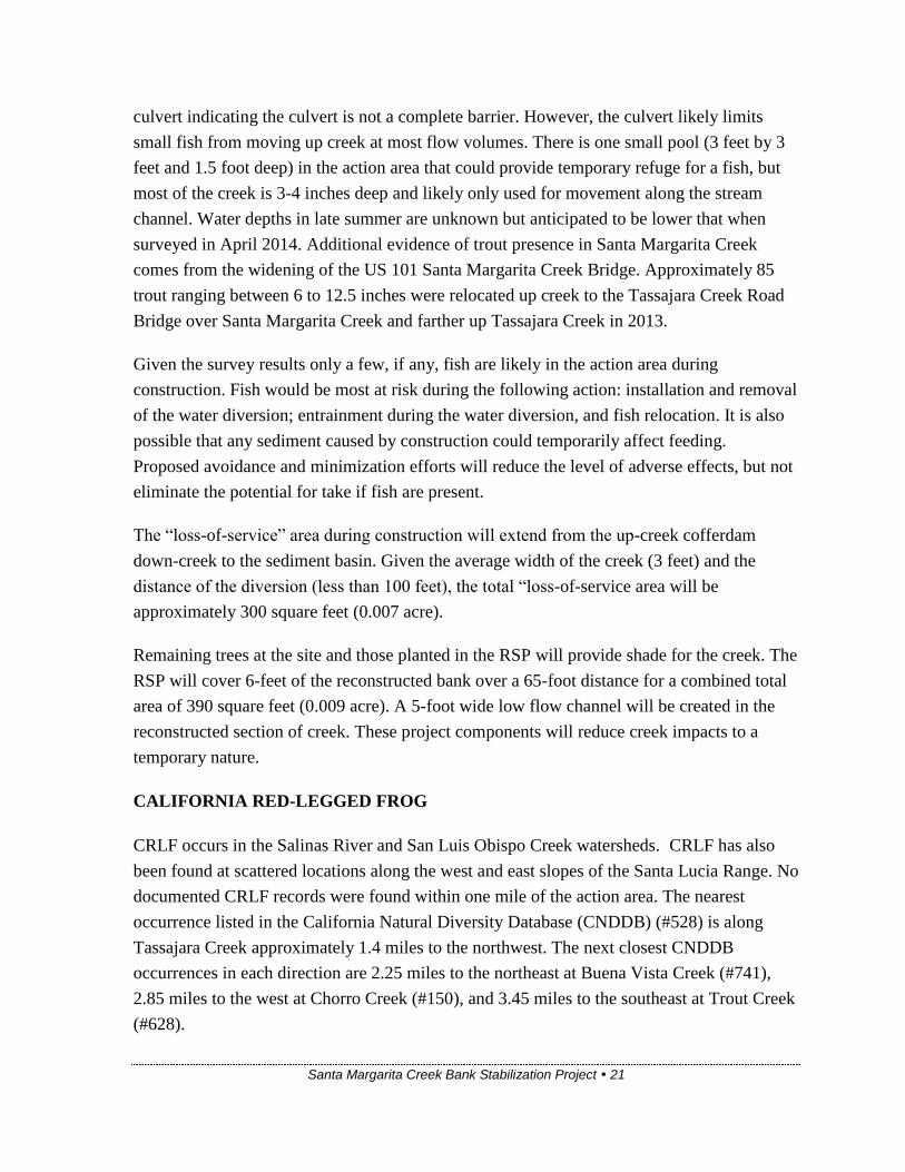
Santa Margarita Creek Bank Stabilization Project 21
culvert indicating the culvert is not a complete barrier. However, the culvert likely limits
small fish from moving up creek at most flow volumes. There is one small pool (3 feet by 3
feet and 1.5 foot deep) in the action area that could provide temporary refuge for a fish, but
most of the creek is 3-4 inches deep and likely only used for movement along the stream
channel. Water depths in late summer are unknown but anticipated to be lower that when
surveyed in April 2014. Additional evidence of trout presence in Santa Margarita Creek
comes from the widening of the US 101 Santa Margarita Creek Bridge. Approximately 85
trout ranging between 6 to 12.5 inches were relocated up creek to the Tassajara Creek Road
Bridge over Santa Margarita Creek and farther up Tassajara Creek in 2013.
Given the survey results only a few, if any, fish are likely in the action area during
construction. Fish would be most at risk during the following action: installation and removal
of the water diversion; entrainment during the water diversion, and fish relocation. It is also
possible that any sediment caused by construction could temporarily affect feeding.
Proposed avoidance and minimization efforts will reduce the level of adverse effects, but not
eliminate the potential for take if fish are present.
The “loss-of-service” area during construction will extend from the up-creek cofferdam
down-creek to the sediment basin. Given the average width of the creek (3 feet) and the
distance of the diversion (less than 100 feet), the total “loss-of-service area will be
approximately 300 square feet (0.007 acre).
Remaining trees at the site and those planted in the RSP will provide shade for the creek. The
RSP will cover 6-feet of the reconstructed bank over a 65-foot distance for a combined total
area of 390 square feet (0.009 acre). A 5-foot wide low flow channel will be created in the
reconstructed section of creek. These project components will reduce creek impacts to a
temporary nature.
CALIFORNIA RED-LEGGED FROG
CRLF occurs in the Salinas River and San Luis Obispo Creek watersheds. CRLF has also
been found at scattered locations along the west and east slopes of the Santa Lucia Range. No
documented CRLF records were found within one mile of the action area. The nearest
occurrence listed in the California Natural Diversity Database (CNDDB) (#528) is along
Tassajara Creek approximately 1.4 miles to the northwest. The next closest CNDDB
occurrences in each direction are 2.25 miles to the northeast at Buena Vista Creek (#741),
2.85 miles to the west at Chorro Creek (#150), and 3.45 miles to the southeast at Trout Creek
(#628).

Santa Margarita Creek Bank Stabilization Project 22
Tassajara Creek is a tributary to Santa Margarita Creek and has several small ponds suitable
for CRLF including one previously mentioned. However, lower in the Santa Margarita
Creek watershed at the US 101 Santa Margarita Creek Bridge bullfrogs (Lithobates
catesbeianus) were abundant during a dewatering action in 2012-2013 and no CRLF were
detected. Based on the CNDDB, the Santa Margarita Ranch appears to have at least a small
population in the upper reaches of the Santa Lucia Range. The species is also known from
numerous locations to the northwest along the Santa Lucia Range and in the Chorro Creek
Valley.
CRLF was not observed during project surveys. These surveys were general in nature and did
not follow USFWS Revised Guidance on Site Assessments and Field Surveys for the CRLF.
Riparian and riverine habitats in the action area provide the physical and biological features
essential to the conservation of the species. It was not observed during project surveys, but is
inferred to be present based on its distribution in the project area.
The project is located in designated critical habitat unit SLO-3. This unit extends from about
Old Creek in Cayucos southwest to Lopez Canyon. Critical habitat is based on the physical
and biological features essential to the conservation of the species, which for CRLF include,
but are not limited to:
(1) Space for individual and population growth and for normal behavior;
(2) Food, water, air, light, minerals, or other nutritional or physiological requirements;
(3) Cover or shelter;
(4) Sites for breeding, reproduction, or rearing (or development) of offspring; and
(5) Habitats that are protected from disturbance or are representative of the historical,
geographical, and ecological distributions of a species.
Based on the species biological needs the primary constituent needs for CRLF are:
(1) Aquatic Breeding Habitat. Standing bodies of fresh water (with salinities less than 4.5
ppt), including natural and manmade (e.g., stock) ponds, slow-moving streams or pools
within streams, and other ephemeral or permanent water bodies that typically become
inundated during winter rains and hold water for a minimum of 20 weeks in all but the driest
of years.
(2) Aquatic Non-Breeding Habitat. Freshwater pond and stream habitats, as described above,
that may not hold water long enough for the species to complete its aquatic life cycle but

Santa Margarita Creek Bank Stabilization Project 23
which provide for shelter, foraging, predator avoidance, and aquatic dispersal of juvenile and
adult CRLFs.
(3) Upland Habitat. Upland areas adjacent to or surrounding breeding and non-breeding
aquatic and riparian habitat up to a distance of 1 mi (1.6 km) in most cases (i.e., depending
on surrounding landscape and dispersal barriers) including various vegetation types such as
grassland, woodland, forest, wetland, or riparian areas that provide shelter, forage, and
predator avoidance for the CRLF.
(4) Dispersal Habitat. Accessible upland or riparian habitat within and between occupied or
previously occupied sites that are located within 1 mi (1.6 km) of each other, and that support
movement between such sites
The project impact area provides physical and biological features essential to the
conservation of the species. It also has the potential to provide three of the four constituent
elements of critical habitat: aquatic non-breeding habitat, upland habitat, and dispersal
habitat. Whether the action area is within or between one-mile of occupied or previously
occupied sites is unknown.
The nearest recorded occurrence in the CNDDB is 1.4 miles to the northwest of the project
site. Based on aerial imagery and topographic maps (Figure 5), the nearest potential breeding
pond (1) is across US 101 approximately 0.3 miles to the northwest. Another pond (2)
associated with the State water project is 0.55 mile to the north. This managed pond is a
concrete structure with no vegetation and appears unlikely to offer breeding habitat. The next
two nearest ponds (3 and 4) are 1.1 and 1.2 miles to the north of the project site.
COAST RANGE NEWT
Like many salamanders, the Coast Range newt (CRN) spends most of its life in terrestrial
habitats such as wet forest, oak forests, chaparral, and rolling grasslands. Adults migrate
from terrestrial habitat to aquatic breeding sites in March and April where they breed.
Typical breeding habitat can include ponds, reservoirs, and sluggish pools in streams.
Transformed juveniles leave the breeding site and travel overland to suitable terrestrial refuge
where they remain for three years before attaining breeding condition.
This species was found during project surveys. Individuals were seen in the project impact
area and just up-creek of the US 101 culvert, and a mass of 25 breeding adults were in a
plunge pool at the outlet of the US 101 culvert. Given these observations this species is
Santa Margarita Creek Bank Stabilization Project 24
clearly present in the action area during the breeding season. US 101 is likely a complete
barrier to overland travel, though animals can move freely up and down creek.
Suitable CRN habitat is present in the action area and site surveys found several animals
including one in the action area. Construction could affect CRN if present; therefore
measures to avoid and minimize adverse affects are being implemented. Primarily the
measures being implemented are those found in the ACOE/USFWS PBO (Appendix E).
The project will have temporary and permanent impacts to CRN habitat. Permanent impacts
will result from the elimination of the creek’s meander toward US 101. Reestablishing the
historic creek bank will move approximately 65 feet of creek away from the highway and
back to its original flow line. This action will require 6 feet of exposed RSP along the
highway-side creek bank. To offset this impact, the base of the RSP will be planted with
native willows and cottonwoods, capped with soil, and seeded with locally occurring natives.
The total area of RSP covered bank will be 390 square feet (0.009 acre). Overall, the toe of
the bank will be moved about 23 feet away from the highway and the total area of fill is
approximately 1,495 square feet (0.034 acre). This reduction in riparian habitat is small
compared to the overall riparian habitat available. It will continue to serve as dispersal
habitat, but will account for at least a temporary reduction in potential summer refugia.
CRN occurs in along the Santa Lucia Range and is known from the Santa Margarita Creek
and San Luis Obispo Creek watersheds. The apparent poor quality breeding habitat in the
action area suggests that if present, only small numbers likely occur there. Implementation of
avoidance and minimization efforts will greatly reduce the potential for take of this species.
SAN LUIS OBISPO PYRG
This small aquatic snail is included on the CNDDB Special Animals List (CDFW 2011).
Little has been published about this invertebrate species which is a member of the largest
genus of freshwater gastropods in North America.
Santa Margarita Creek and the project impact area appear to support suitable habitat for San
Luis Obispo pyrg, however this species was not detected during project surveys.
Environmental Consequences
SOUTH-CENTRAL CALIFORNIA COAST STEELHEAD
Potential adverse affects to steelhead could occur during the following activities:

Santa Margarita Creek Bank Stabilization Project 25
Installation and removal of the water diversion
Entrainment during the water diversion
Fish relocation (if needed)
Sediment released into the creek during construction
CALIFORNIA RED-LEGGED FROG
Potential adverse affects to CRLF could occur during the following activities:
Vegetation clearing
Installation and removal of the water diversion
Entrainment during the water diversion
Sediment removal
Equipment operation
Relocation efforts (if needed)
Sediment released into the creek during construction
COAST RANGE NEWT
Potential adverse affects to CRN could occur during the following activities:
Vegetation clearing
Project construction (excavation)
Installation and removal of the water diversion
Entrainment during the water diversion
Relocation efforts (if needed)
Sediment released into the creek during construction
SAN LUIS OBISPO PYRG
Project construction could result in the injury or mortality of San Luis Obispo pyrg (if
present) during diversion/dewatering to accommodate the slope repair. The potential
need to capture and relocate this species could subject it to stresses (e.g., temporary
removal from aquatic habitat, desiccation, relocation to unfamiliar aquatic habitat)
that could result in adverse effects. Injury or mortality could also occur via accidental
crushing by worker foot-traffic or construction equipment. The potential for these
impacts is anticipated to be low due to no observations of the species within the BSA
during surveys.

Santa Margarita Creek Bank Stabilization Project 26
Avoidance, Minimization, and/or Mitigation Measures
SOUTH-CENTRAL CALIFORNIA COAST STEELHEAD
The project location between US 101 and the railroad limited potential project modifications
and alternatives. Nonetheless, the project has been designed to protect habitat and reduce the
potential for adverse effects to steelhead.
In addition to the avoidance measures Bio-1 to 9 outlined in the Wetlands and Other Waters
of the US (Aquatic) section, the following measures will be employed to avoid and minimize
adverse affects to steelhead:
Bio-10. Prior to the start of construction a qualified biologist shall present a worker
awareness training to all construction personnel, and the Resident Engineer and/or his
designee.
Bio-11. A qualified biologist shall be onsite during installation and removal of the water
diversion and all initial ground disturbing activities. A qualified biologist is one with
previous experience monitoring cofferdam installation and moving steelhead. The
qualified biologist will be responsible for monitoring the diversion.
CALIFORNIA RED-LEGGED FROG
The project location between US 101 and the railroad limited potential project modifications
and alternatives. Nonetheless, the project has been designed to protect habitat and reduce the
potential for adverse effects to CRLF.
The ACOE will be the lead federal agency for Section 7 of the Federal Endangered Species
Act (FESA). It is presumed that the ACOE will utilize the Programmatic Formal Endangered
Species Act Consultation on Issuance of Permits under Section 404 of the Clean Water Act
or Authorization under the Nationwide Permit Program for Projects that May Affect the
California Red-legged Frog (PBO). In addition to the avoidance efforts outlined in the PBO,
Bio-1 through Bio-7 efforts listed in the previous Aquatic section of this report will be
employed to avoid and minimize adverse affects to CRLF.
Bio-12. Avoidance measures found in the ACOE/USFWS CRLF PBO shall be
implemented during construction.

Santa Margarita Creek Bank Stabilization Project 27
Bio-13. Caltrans requests that Tom Edell be approved to carry out the measures listed in
the CRLF PBO.
Tom Edell and/or Nancy Siepel will act as the Service-approved biologists. Both individuals
are currently Service-approved under the Programmatic Biological Opinion for Project
Funded or Approved under the Federal Highway Administration Federal Aid Program (8-8-
10-F-58) and have extensive experience surveying for and handling CRLF.
COAST RANGE NEWT
The project location between US 101 and the railroad limited potential project modifications
and alternatives. Nonetheless, the project has been designed to protect habitat and reduce the
potential for adverse effects to CRN. Efforts outlined in the CRLF PBO and Bio-1 through
Bio-7 efforts listed in the previous Aquatic section of this report will be employed to avoid
and minimize adverse affects to CRN. In particular the projected construction timing will
avoid this species breeding season and occur when animals are anticipated to be in terrestrial
habitat away from the action area.
SAN LUIS OBISPO PYRG
Recommended avoidance and minimization measures for San Luis Obispo pyrg include the
following:
Bio-14. During pre-construction surveys and/or during construction, if biologists observe
any Pyrgulopsis spp., they will be relocated to suitable aquatic habitat outside of the area
of impact.

Santa Margarita Creek – Bank Stabilization
Santa Margarita Creek Bank Stabilization Project 28
Appendix A – Site Photos
Photo 1: Eroded bank, March 2014
Photo 2: Eroded bank, April 2014

Santa Margarita Creek – Bank Stabilization
Santa Margarita Creek Bank Stabilization Project 29
Photo 3. brush pile at up creek end of meander into the State R/W, April 2014
Photo 4. Eroded bank, April 2014

Santa Margarita Creek – Bank Stabilization
Santa Margarita Creek Bank Stabilization Project 30
Photo 5. Looking down creek, April 2014
Photo 6. Looking up creek, April 2014

Santa Margarita Creek – Bank Stabilization
Santa Margarita Creek Bank Stabilization Project 31
Appendix B – Regional Species of Concern
Table 5. Regional Plant Species of Concern
Common Name Scientific Name
Status
Federal /
State / CNPS
Status
General Habitat Description
Habitat
Present/
Absent
Rationale
Brewer’s
spineflower
Chorizanthe
breweri -- / -- / 1B.3
Annual herb; occurs in closed-cone coniferous forest,
chaparral, cismontane woodland, coastal scrub
Soils: serpentinite, rocky or gravely
Blooms March-May
45-800 meters (145-2625 feet)
A
No suitable habitat in BSA.
No serpentinite present
No further studies recommended.
Cambria
Morning Glory
Calystegia
subacaulis ssp.
episcopalis
-- / -- / 4.2
Perennial rhizomatous herb; occurs in chaparral,
cismontane woodland
Blooms April-May
30-500 meters (100-1640 feet)
A No suitable habitat in BSA.
No further studies recommended.
Chorro Creek
bog thistle
Cirsium fontinale
var. obispoense
FE / SE /
1B.2
Perennial herb; occurs in chaparral, cismontane
woodland, coastal scrub, and valley and foothill
grassland; serpentine seeps and drainages
Blooms February-September
35-380 meters (115-1250 feet)
A
No suitable habitat in BSA.
No serpentinite present
No further studies recommended.
Cuesta Pass
checkerbloom
Sidalcea hickmanii
ssp. Anomala -- / -R / 1B.2
Perennial herb; occurs in closed-cone coniferous forest
(serpentinite)
Blooms May-June
600-800 meters (1979-2625 feet)
A
No suitable habitat in BSA.
No serpentinite present
No further studies recommended
Cuesta Ridge
thistle
Cirsium
occidentale var.
lucianum
-- / -- / 1B.2
Perennial herb; occurs in chaparral openings, often on
steep rocky slopes and disturbed roadsides. Serpentinite
Blooms April-June
500-750 meters (1640-2460 feet)
A
No suitable habitat in BSA.
No serpentinite present
No further studies recommended
dwarf soaproot
Chlorogalum
pomeridianum var.
minus
-- / -- / 1B.2
Perennial bulbiferous herb; occurs in chaparral
(serpentinite)
Blooms: May-August
305 - 1000 meters (1000-3280 feet)
A
No suitable habitat in BSA.
No serpentinite present
No further studies recommended
hooked
popcornflower
Plagiobothrys
uncinatus -- / -- / 1B.2
Annual herb; chaparral (sandy), cismontane woodland,
valley and foothill grassland
Blooms: April-May
200-760 meters (985-2495 feet)
No suitable habitat in BSA.
No further studies recommended

Santa Margarita Creek – Bank Stabilization
Santa Margarita Creek Bank Stabilization Project 32
Common Name Scientific Name
Status
Federal /
State / CNPS
Status
General Habitat Description
Habitat
Present/
Absent
Rationale
Gambel's water
cress
Nasturtium
gambelii
FE / ST /
1B.1
Perennial stoloniferous herb; occurs in sandy areas and
openings in freshwater or brackish marshes and swamps
Flowers May-August
3-170 meters (10-560 feet)
A
No suitable habitat in BSA.
No watercress present
No further studies recommended.
mesa horkelia Horkelia cuneata
var. puberula -- / -- / 1B.1
Perennial herb; occurs in chaparral (maritime),
cismontane woodland, coastal scrub.
Blooms: February-September
70-810 meters (230-2660 feet)
A No suitable habitat in BSA.
No further studies recommended.
marsh sandwort Arenaria
paludicola
FE / SE /
1B.1
Perennial stoloniferous herb; occurs in freshwater or
brackish marshes and swamps/sandy areas and openings
Blooms: May-August
3-170 meters (10-560 feet)
A No suitable habitat in the BSA.
No further studies recommended.
Morro Manzanita Arctostaphylos
morroensis FT /
Perennial evergreen shrub; occurs in Baywood fine sand.
Chaparral (maritime), cismontane woodland, coastal
dunes (pre-Flandrian). Coastal scrub
Blooms: December-March
5-205 meters (15-675 feet)
A No suitable habitat in the BSA.
No further studies recommended
Palmer’s
monardella
Monardella
palmeri -- / -- / 1B.2
Perennial rhizomatous herb; occurs in serpentinite;
chaparral, cismontane woodland
Blooms: June-August
200-800 meters (655-2625 feet)
A
No suitable habitat in the BSA.
No serpentinite present
No further studies recommended
San Benito
fritillary Fritillaria viridea -- / -- / 1B.2
Perennial bulbiferous herb; occurs in chaparral
(serpentinite)
Blooms: March-May
200-1525 meters (655-5000 feet)
A
No suitable habitat in the BSA.
No serpentinite present
No further studies recommended
San Luis Obispo
mariposa-lily
Calochortus
obispoensis -- / -- / 1B.2
Perennial bulbiferous herb; often serpentinite; occurs in
chaparral, coastal scrub, valley and foothill grassland
Blooms May-July
50-730 meters (165-2400 feet)
A No suitable habitat in the BSA.
No further studies recommended
San Luis Obispo
sedge Carex obispoensis -- / -- / 1B.2
Perennial rhizomatous herb; closed cone coniferous
forest, chaparral, coastal prairie, coastal scrub, valley
and foothill grassland
Soils: often serpentinite seeps, sometimes gabbro, often
on clay soils
Blooms:April-June
10-820 meters (30-2700 feet)
A
No suitable habitat in the BSA.
No serpentinite present
No further studies recommended

Santa Margarita Creek – Bank Stabilization
Santa Margarita Creek Bank Stabilization Project 33
Common Name Scientific Name
Status
Federal /
State / CNPS
Status
General Habitat Description
Habitat
Present/
Absent
Rationale
Santa Lucia
manzanita
Arctostaphylos
luciana -- / -- / 1B.2
Perennial evergreen shrub; shale; chaparral, cismontane
woodland
Blooms: December-March
350-850 meters (1150-2800 feet)
A No suitable habitat in the BSA.
No further studies recommended
Santa Margarita
Manzanita
Arctostaphylos
pilosula -- / -- / 1B.2
Perennial evergreen shrub; sometimes sandstone;
broadleafed upland forest, closed-cone coniferous forest,
chaparral, cismontane woodland
Blooms: December-May
170-1100 meters (560-3610 feet)
A No suitable habitat in the BSA.
No further studies recommended
Spreading
navarretia Navarretia fossalis FT / -- / 1B.1
Annual herb; chenopod shrub, marshes and swamps
(assorted shallow freshwater), playas, vernal pools
Blooms: April-June
30-655 meters (100-2150 feet)
A No suitable habitat in the BSA.
No further studies recommended
Status Codes:
Federal:
FE = Federal Endangered
FT = Federal Threatened
State:
SE = State Endangered
ST = State Threatened
SR = State Rare
California Native Plant Society (CNPS):
List 1B = rare, threatened, or endangered in California and elsewhere.
List 2 = rare, threatened, or endangered in California, but more common elsewhere.
List 4 = limited distribution (Watch List).
CNPS Threat Code:
.1 = Seriously endangered in CA (over 80% of occurrences threatened / high degree and immediacy of
threat)
.2 = Fairly endangered in CA (20-80% occurrences threatened)
.3 = Not very endangered in CA (<20% of occurrences threatened or no current threats known)
Habitat Present/Absent
Absent [A]-no habitat present and no further work needed. Habitat Present [HP]-habitat is, or may be
present. Present [P]-the species is present. Critical Habitat [CH] – the project footprint is located
within a designated critical habitat unit, but does not necessarily mean that appropriate habitat is
present.

Santa Margarita Creek – Bank Stabilization
Santa Margarita Creek Bank Stabilization Project 34
Table 6. Regional Animal Species of Concern
Common Name Scientific Name
Status
Federal /
State / CDFG
General Habitat Description
Habitat
Present/
Absent
Rationale
Invertebrates
San Luis Obispo
pyrg
Pyrgulopsis
taylori -- / -- / --
Occurs in freshwater habitats including slow moving streams,
seeps and springs. Occurrences along the western side of the
Santa Lucia Range on San Luis Obispo Creek (Cuesta Pass),
Chorro Creek, and Brizziolari Creek..
P
No gastropod mollusks observed
during project surveys.
No further surveys recommended
vernal pool fairy
shrimp (vernal
pool
branchiopods)
Branchinecta
lynchi FT / -- / --
Endemic to the grasslands of the Central Valley, Central
Coast mountains, and South Coast mountains, in astatic rain-
filled pools. Inhabit small, clear-water sandstone-depression
pools and grassed swale, earth slump, or basalt-flow
depression pools.
A No suitable habitat in the BSA.
No further studies recommended.
Mammals
American Badger Taxidea taxus -- / -- / SSC
Typically occurs in open grasslands with sandy loam soils
allowing excavation of dens and pursuit of prey A
No suitable habitat in the BSA.
No suitable burrows noted during
surveys
No further studies recommended.
pallid bat Antrozous pallidus -- / -- / SSC
Roosts in small colonies in rock crevices, caves, mine shafts,
under bridges, in buildings and tree hollows. A
No suitable roost sites in or
adjacent to project impact area.
No further studies required
Fish
steelhead
south/central
California coast
DPS
Oncorhynchus
mykiss irideus FT / -- / SSC
Federal listing refers to runs in coastal basins from the Pajaro
River south to, but not including, the Santa Maria River.
P
Suitable habitat in the BSA.
Action area outside of CH
12-14 inch and 6-8 inch trout
observed down creek of action
area.
Amphibians
California tiger
salamander
Ambstoma
californiense FT / ST / --
Upland habitat: burrows in grassland, oak savannah, edges of
mixed woodland and low elevation coniferous forest.
Breeding habitat: seasonal ponds, occasionally reservoirs or
slow moving portions of creeks.
A
No suitable breed habitat in project
area
Species not known to occur in
surrounding area

Santa Margarita Creek – Bank Stabilization
Santa Margarita Creek Bank Stabilization Project 35
Common Name Scientific Name
Status
Federal /
State / CDFG
General Habitat Description
Habitat
Present/
Absent
Rationale
California red-
legged frog Rana draytonii
FT, CH / -- /
SSC
Aquatic habitats with little or no flow, the presence of surface
water to at least early June, surface water depths to at least
2.3 feet, and fairly sturdy underwater supports such as
cattails. P
No suitable breeding habitat in the
BSA.
Suitable non-breeding habitat
present
Action area within CH
No further studies recommended.
foothill yellow-
legged frog Rana boylii -- / -- / SSC
Rocky streams in with sunny banks in forests, chaparral, and
woodlands. Occurs in isolated pools, vegetated backwaters,
and shaded, spring-fed pools.
370-3660 meters (984-12000 feet) P
No suitable breeding habitat in the
BSA.
Suitable non-breeding habitat
present
No longer occurs south of
Monterey County (Nafis, 2014)
No further studies recommended.
Coast Range newt Taricha torosa -- / -- / SSC
Chaparral, oak woodland, and grasslands. Adults migrate to
ponds, reservoirs, and sluggish pools in streams to breed.
Occurs from sea level to 1280 meters (4200 feet). P
Suitable breeding habitat down
creek
Observed up and down creek of
Hwy 101 culvert
Reptiles
western pond
turtle Emys marmorata -- / -- / SSC
Quiet waters of ponds, lakes, streams, and marshes.
Typically in the deepest parts with an abundance of basking
sites.
A No suitable habitat in the BSA.
No further studies recommended.
Birds
California condor Gymnogyps
californianus
FE / SE, FP /-
-
Nests in association with rocky cliffs. Forages in open
savannah, grasslands, and foothill chaparral with cliffs, trees,
and snags. A
No suitable breeding habitat in the
BSA.
No further studies recommended.
least Bell’s vireo Vireo bellii
pusillus FE / SE /--
(Nesting) summer resident of southern California in low
riparian habitats near water or in dry river bottoms, below
2,000 ft. Nests placed along margins of bushes or on twigs
projecting into pathways, willows, coyote brush, or mesquite. A
Marginal habitat in the project
area
Construction will occur outside
the nesting season
No further studies recommended.
Southwestern
willow flycatcher
Empidonax traillii
extimus FE / SE / --
(Nesting) summer resident of Southwest US in dense
riparian tree and shrub communities associated with rivers,
swamps, and wetlands. Prefers areas of dense vegetation
interspersed with a mosaic of small openings, open water, or
shorter/sparser vegetation.
A
No known breeding records for
San Luis Obispo County.
Construction will occur outside of
the nesting season
Project not within designated
critical habitat

Santa Margarita Creek – Bank Stabilization
Santa Margarita Creek Bank Stabilization Project 36
Common Name Scientific Name
Status
Federal /
State / CDFG
General Habitat Description
Habitat
Present/
Absent
Rationale
other nesting
birds Class Aves
MBTA / -- /
CDFG
Section 3503
Various habitats (nesting).
P
Suitable nesting habitat occurs in
trees and poison oak thickets
within the BSA.
No nesting birds observed during
surveys.
Construction will occur outside of
the nesting season
Status Codes:
Federal:
FE = Federal Endangered
FT = Federal Threatened
FC = Federal Candidate
FD = Federal Delisted
MBTA = Protected by Federal Migratory Bird
Treaty Act
State:
SE = State Endangered
ST = State Threatened
SD = State Delisted
FP = Fully Protected
California Department of Fish and Wildlife:
SSC = California Species of Special Concern
WL = CDFW Watch List species
SA = Included on CNDDB Special Animals List (also protected under CEQA)
FGC Section 3503 = Protected by Fish and Game Code Section 3503
Habitat Present/Absent
Absent [A]-no habitat present and no further work needed. Habitat Present [HP]-habitat is, or may be
present. Present [P]-the species is present. Critical Habitat [CH] – the project footprint is located
within a designated critical habitat unit, but does not necessarily mean that appropriate habitat is
present.

Santa Margarita Creek – Bank Stabilization
Santa Margarita Creek Bank Stabilization Project 37
Appendix C – U.S. Fish and Wildlife Service Species List

Santa Margarita Creek – Bank Stabilization
Santa Margarita Creek Bank Stabilization Project 38

Santa Margarita Creek – Bank Stabilization
Santa Margarita Creek Bank Stabilization Project 39

Santa Margarita Creek – Bank Stabilization
Santa Margarita Creek Bank Stabilization Project 40

Santa Margarita Creek – Bank Stabilization
Santa Margarita Creek Bank Stabilization Project 41

Santa Margarita Creek Bank Stabilization Project 42
Appendix D – California Natural Diversity Database

Santa Margarita Creek Bank Stabilization Project 43